Conservation Planning evaluate land management alternatives to reduce soil erosion to acceptable levels. Resource Inventories estimate current and
|
|
|
- Rosanna Jackson
- 5 years ago
- Views:
Transcription

1
2 Conservation Planning evaluate land management alternatives to reduce soil erosion to acceptable levels. Resource Inventories estimate current and projected erosion levels and their impact on natural resource base. Estimate sediment generation and delivery off-site, and evaluate management strategies to minimize sediment losses and impacts.
3 Process-based Distributed parameter Continuous simulation Erosion prediction model implemented on personal computers User-friendly interfaces & input creation utilities Large databases for U.S.


4 Predict sheet & rill erosion, sediment deposition, and sediment delivery from hillslopes. Estimate erosion & deposition in channels such as ephemeral gullies and grass waterways.

5 Determine impacts of impoundments Predict runoff & sediment delivery from small watersheds
6
7
8

9 Determine erosion and sediment yield rates based upon current land management Evaluate various management strategies, including various Crop rotations Tillage alternatives Strip cropping Waterways etc.

10 Determine impacts of present range management Predict effects of changing management Grazing level Burning Herbicides

11 Forest Planning Impacts of: Timber harvesting Road construction Road maintenance Road traffic Controlled burning Off-site impacts Stream water quality Fish spawning areas
12 Temporal and spatial estimates of soil erosion. Estimates of sediment deposition and delivery from hillslope profiles Estimates of detachment and deposition of sediment in ephemeral gullies and other small channels. Prediction of sediment deposition in impoundments.
13 Models the important physical processes governing erosion (climate, infiltration, runoff, ET, detachment by raindrops, detachment by flowing water, deposition, etc.). Simulation of nonuniform slope, soils, cropping/management. Large U.S. databases for climate, soils, and crops.
14 Use currently limited to hillslope profiles and small watersheds Limited to rainfall/snowmelt/irrigation water inputs that result in overland flow runoff No perennial stream processes No classical gully processes Large number of model inputs are required due to the many model components. Databases must be populated if WEPP is to be easily used by field level conservationists.
15 Climate Simulation Surface & Subsurface Hydrology Water Balance & Percolation Soil Component (Tillage impacts) Plant Growth & Residue Decomposition Overland Flow Hydraulics Hillslope Erosion Component Channel Hydrology & Hydraulics Channel Erosion Surface Impoundment Element
16 Stochastic weather generator (CLIGEN) Daily updating of soil, plant, residue params. Infiltration predicted using a Green-Ampt equation modified for unsteady rainfall. Runoff volume is predicted from rainfall excess adjusted for depressional storage. Peak runoff rates using kinematic wave eqn. Steady-state sediment continuity equation. Detachment function of rain intensity, excess flow shear stress, adj. erodibilities, crit shr. Modified Yalin equation for sed. trans. cap.
17 Natural runoff plots (Zhang et al., 1996) Small watersheds (Liu et al., 1997) Other studies, including natural runoff plots, rainfall simulator studies, small watersheds, both within and outside the United States.
18 WEPP Predicted Soil Loss (kg/m 2 ) Thousands of plot years of data, from USLE repository r 2 = 0.85, Nash-Sutcliffe ME = 0.88 for average annual soil loss : Measured Soil Loss (kg/m 2 )
 Channel parameter file (watershed) Impoundment parameter file")
19 Slope File Soil File Climate File Management File Irrigation File (optional) Watershed structure file (watershed) Channel parameter file (watershed) Impoundment parameter file (watershed)
20 Daily, monthly, annual, and/or average annual runoff, soil loss, sediment yield Spatial distribution of soil loss and graphical depictions on profiles Graphical viewing of daily parameters and model output values (list of 92 variables) Special text output files with info on plant growth, soil, water balance, etc.

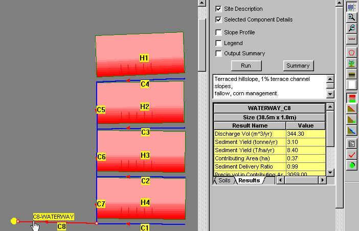
21 Profile depicted graphically in 2-D/3-D. Graphic image hot and allows viewing & editing of underlying parameters. Can copy, cut, paste, & delete soil or mgmt. regions. Erosion & deposition rates shown in shades of red & green in center profile layer.

22 Background image can be used, such as a scanned photo. Project can be scaled to known landmarks on image. Graphic is hot and allows viewing/editing of underlying input parameters. Top view of erosion & deposition in shades of red & green can show trouble areas needing treatment.
23

24 WEPP channels WEPP hillslopes
 and DRG")

25 GeoWEPP Interface showing sub-basins generated. Geospatial interface to WEPP allows easy access to commonly available DEM (digital elevation model) and DRG (digital raster graph) data from the Internet. Users may also access their own data, if better quality from another source. GeoWEPP users TOPAZ and DEM data to outline channel networks in region of interest. Based on user s selection of outlet point, sub-basins are automatically generated.

26 Sediment yield depicted graphically. Soil detachment or deposition depicted graphically. WEPP can be run based on representative profile for each subbasin that is created based upon all flow paths in sub-basin. This quicker approach allows rapid problem identification. Other alternative is to run WEPP hillslope simulations for every flow path more timeconsuming but allows detailed graphical depiction of soil loss and deposition in GIS.

27
Watershed Application of WEPP and Geospatial Interfaces. Dennis C. Flanagan
 Watershed Application of WEPP and Geospatial Interfaces Dennis C. Flanagan Research Agricultural Engineer USDA-Agricultural Research Service Adjunct Professor Purdue Univ., Dept. of Agric. & Biol. Eng.
Chapter 1. OVERVIEW OF THE WEPP EROSION PREDICTION MODEL
 1.1 Chapter 1. OVERVIEW OF THE WEPP EROSION PREDICTION MODEL D.C. Flanagan, J.C. Ascough II, A.D. Nicks, M.A. Nearing and J.M. Laflen 1.1 Introduction The USDA - Water Erosion Prediction Project (WEPP)
Chapter 2. Commonalities in WEPP and WEPS and Efforts Towards a Single Erosion Process Model
 Chapter 2 Commonalities in WEPP and WEPS and Efforts Towards a Single Erosion Process Model D.C. Flanagan 1 & S.M. Visser 2 1 Agricultural Engineer & WEPP Leader USDA - Agricultural Research Service &
WEPP: MODEL USE, CALIBRATION,
 WEPP: MODEL USE, CALIBRATION, AND VALIDATION D. C. Flanagan, J. R. Frankenberger, J. C. Ascough II ABSTRACT. The Water Erosion Prediction Project (WEPP) model is a process-based, continuous simulation,
Development of a GIS Interface for WEPP Model Application to Great Lakes Forested Watersheds
 Development of a GIS Interface for WEPP Model Application to Great Lakes Forested Watersheds J.R. Frankenberger 1, S. Dun 2, D.C. Flanagan 1, J.Q. Wu 2, W.J. Elliot 3 1 USDA-ARS, West Lafayette, IN 2 Washington
Watershed Conservation Management Planning Using the Integrated Field & Channel Technology of AnnAGNPS & CONCEPTS
 Watershed Conservation Management Planning Using the Integrated Field & Channel Technology of AnnAGNPS & CONCEPTS Eddy Langendoen Ron Bingner USDA-ARS National Sedimentation Laboratory, Oxford, Mississippi
Model Integration - How WEPP inputs are calculated from GIS data. ( ArcGIS,TOPAZ, Topwepp)
") Model Integration - How WEPP inputs are calculated from GIS data. ( ArcGIS,TOPAZ, Topwepp) ArcGIS 9.1-9.3 Allows user to locate area of interest, assemble grids, visualize outputs. TOPAZ Performs DEM
Model Integration - How WEPP inputs are calculated from GIS data. ( ArcGIS,TOPAZ, Topwepp) ArcGIS 9.1-9.3 Allows user to locate area of interest, assemble grids, visualize outputs. TOPAZ Performs DEM
USDA-Agricultural Research Service (ARS)
") THE WEPP WATERSHED MODEL: I. HYDROLOGY AND EROSION J. C. Ascough II, C. Baffaut, M. A. Nearing, B. Y. Liu ABSTRACT. The Water Erosion Prediction Project (WEPP) watershed scale model is a continuous simulation
THE WEPP WATERSHED MODEL: I. HYDROLOGY AND EROSION J. C. Ascough II, C. Baffaut, M. A. Nearing, B. Y. Liu ABSTRACT. The Water Erosion Prediction Project (WEPP) watershed scale model is a continuous simulation
12 SWAT USER S MANUAL, VERSION 98.1
 12 SWAT USER S MANUAL, VERSION 98.1 CANOPY STORAGE. Canopy storage is the water intercepted by vegetative surfaces (the canopy) where it is held and made available for evaporation. When using the curve
Adapting WEPP (Water Erosion Prediction Project) for Forest Watershed Erosion Modeling
 for Forest Watershed Erosion Modeling") Adapting WEPP (Water Erosion Prediction Project) for Forest Watershed Erosion Modeling Joan Q. Wu Arthur C. Xu William J. Elliot Department of Biological Systems Engineering Rocky Mountain Research Station
Adapting WEPP (Water Erosion Prediction Project) for Forest Watershed Erosion Modeling Joan Q. Wu Arthur C. Xu William J. Elliot Department of Biological Systems Engineering Rocky Mountain Research Station
GeoWEPP Tutorial Appendix
 GeoWEPP Tutorial Appendix Chris S. Renschler University at Buffalo - The State University of New York Department of Geography, 116 Wilkeson Quad Buffalo, New York 14261, USA Prepared for use at the WEPP/GeoWEPP
Hydrologic Modelling of the Upper Malaprabha Catchment using ArcView SWAT
 Hydrologic Modelling of the Upper Malaprabha Catchment using ArcView SWAT Technical briefs are short summaries of the models used in the project aimed at nontechnical readers. The aim of the PES India
ADAPTING WEPP (WATER EROSION PREDICTION PROJECT) FOR FOREST WATERSHED EROSION MODELING SHUHUI DUN
 FOR FOREST WATERSHED EROSION MODELING SHUHUI DUN") ADAPTING WEPP (WATER EROSION PREDICTION PROJECT) FOR FOREST WATERSHED EROSION MODELING By SHUHUI DUN A thesis submitted in partial fulfillment of the requirements for the degree of MASTER OF SCIENCE IN
ADAPTING WEPP (WATER EROSION PREDICTION PROJECT) FOR FOREST WATERSHED EROSION MODELING By SHUHUI DUN A thesis submitted in partial fulfillment of the requirements for the degree of MASTER OF SCIENCE IN
CHAPTER 2 LITERATURE REVIEW
 7 CHAPTER 2 LITERATURE REVIEW A broad understanding of various topics in environmental science and modeling technology was required to complete the studies presented in this thesis, and it is important
INTRODUCTION TO HEC-HMS
 INTRODUCTION TO HEC-HMS Hydrologic Engineering Center- Hydrologic Modeling System US Army Corps of Engineers Hydrologic Engineering Center HEC-HMS Uses Schematics Enter properties: watershed, rivers (reaches),
KINEROS2/AGWA. Fig. 1. Schematic view (Woolhiser et al., 1990).
.") KINEROS2/AGWA Introduction Kineros2 (KINematic runoff and EROSion) (K2) model was originated at the USDA-ARS in late 1960s and released until 1990 (Smith et al., 1995; Woolhiser et al., 1990). The spatial
KINEROS2/AGWA Introduction Kineros2 (KINematic runoff and EROSion) (K2) model was originated at the USDA-ARS in late 1960s and released until 1990 (Smith et al., 1995; Woolhiser et al., 1990). The spatial
Subject Name: SOIL AND WATER CONSERVATION ENGINEERING 3(2+1) COURSE OUTLINE
 COURSE OUTLINE") Subject Name: SOIL AND WATER CONSERVATION ENGINEERING 3(2+1) COURSE OUTLINE (Name of Course Developer: Prof. Ashok Mishra, AgFE Department, IIT Kharagpur, Kharagpur 721 302) Module 1: Introduction and
Subject Name: SOIL AND WATER CONSERVATION ENGINEERING 3(2+1) COURSE OUTLINE (Name of Course Developer: Prof. Ashok Mishra, AgFE Department, IIT Kharagpur, Kharagpur 721 302) Module 1: Introduction and
Modeling soil erosion by water on agricultural land in Cenei, Timiş County, Romania
 Modeling soil erosion by water on agricultural land in Cenei, Timiş County, Romania GEORGE NARCIS PELEA, IOANA ALINA COSTESCU, ERIKA BEILICCI, TEODOR EUGEN MAN, ROBERT BEILICCI Faculty of Civil Engineering,
REPRESENTATIVE HILLSLOPE METHODS FOR APPLYING
 REPRESENTATIVE HILLSLOPE METHODS FOR APPLYING THE WEPP MODEL WITH DEMS AND GIS T. A. Cochrane, D. C. Flanagan ABSTRACT. In watershed modeling with WEPP, the process of manually identifying hillslopes and
Streams. Anurag Srivastava
 Application and Evaluation of WEPP in a Forested Watershed with Perennial Streams by Anurag Srivastava A thesis submitted to the Graduate Faculty of Auburn University in partial fulfillment of the requirements
Recent findings related to measuring and modeling forest road erosion
 18 th World IMACS / MODSIM Congress, Cairns, Australia 13-17 July 2009 http://mssanz.org.au/modsim09 Recent findings related to measuring and modeling forest road erosion W. J. Elliot 1, R. B. Foltz 1
WEPP USER SUMMARY. USDA- Water Erosion Prediction Project. Hillslope. Watershed. Soil loss. Interrill-Rill Erosion. yield. Deposition.
 B U R E A U O F L A N D M A N A G E M E N T WEPP USER SUMMARY U.S. DEPARTMENT OF THE INTERIOR USDA- Water Erosion Prediction Project Soil loss Hillslope Interrill-Rill Erosion Watershed Sediment yield
Great Lakes Online Watershed Interface W. Elliot, Research Engineer USDA Forest Service Rocky Mountain Research Station, Moscow, ID March, 2016
 Great Lakes Online Watershed Interface W. Elliot, Research Engineer USDA Forest Service Rocky Mountain Research Station, Moscow, ID March, 2016 Guidelines for using the Web WEPP Watershed Tool to Support
The WEPP online GIS interface uses the OpenLayers (http://openlayers.org/) software to assist in setting
 software to assist in setting") WEPP Online GIS OpenLayers/Google Maps Interface February 15,2011 Website: http://milford.nserl.purdue.edu/ol/wepp/ The WEPP online GIS interface uses the OpenLayers (http://openlayers.org/) software to
WEPP Online GIS OpenLayers/Google Maps Interface February 15,2011 Website: http://milford.nserl.purdue.edu/ol/wepp/ The WEPP online GIS interface uses the OpenLayers (http://openlayers.org/) software to
Analysis of Road Sediment Accumulation to Monumental Creek using the GRAIP Method
 Analysis of Road Sediment Accumulation to Monumental Creek using the GRAIP Method Introduction (from http://www.neng.usu.edu/cee/faculty/dtarb/graip/#over): The Geomorphologic Road Analysis and Inventory
Remote Sensing and GIS Applications for Hilly Watersheds SUBASHISA DUTTA DEPARTMENT OF CIVIL ENGINEERING IIT GUWAHATI
 Remote Sensing and GIS Applications for Hilly Watersheds SUBASHISA DUTTA DEPARTMENT OF CIVIL ENGINEERING IIT GUWAHATI Deciding Alternative Land Use Options in a Watershed Using GIS Source: Anita Prakash
Roger Andy Gaines, Research Civil Engineer, PhD, P.E.
 Roger Andy Gaines, Research Civil Engineer, PhD, P.E. Research Civil Engineer/Regional Technical Specialist Memphis District August 24, 2010 Objectives Where we have been (recap of situation and what s
GeoWEPP The Geo-spatial interface for the Water Erosion Prediction Project
 This is not a peer-reviewed article Paper Number: 022171 An ASAE Meeting Presentation GeoWEPP The Geo-spatial interface for the Water Erosion Prediction Project Chris S. Renschler University at Buffalo
Regionalization Methods for Watershed Management - Hydrology and Soil Erosion from Point to Regional Scales
 This paper was peer-reviewed for scientific content. Pages 1062-1067. In: D.E. Stott, R.H. Mohtar and G.C. Steinhardt (eds). 2001. Sustaining the Global Farm. Selected papers from the 10th International
Implementing a process-based decision support tool for natural resource management - the GeoWEPP example
 Implementing a process-based decision support tool for natural resource management - the GeoWEPP example Chris S. Renschler a and Dennis C. Flanagan b a Dept. of Geography, University at Buffalo - The
Chapter 10. HYDRAULICS OF OVERLAND FLOW
 10.1 Chapter 10. HYDRAULICS OF OVERLAND FLOW J.E. Gilley and M.A. Weltz 10.1 Introduction Proper identification of hydraulic parameters is essential for the operation of other WEPP model components. Routing
EXAMPLE WATERSHED CONFIGURATIONS
 APPENDIX B EXAMPLE WATERSHED CONFIGURATIONS The watershed configuration file defines the spatial relationship of objects within the watershed. The three techniques used to subdivide a watershed are the
Application of the WEPP model with digital geographic information GIS/EM4 No. 149
 4th International Conference on Integrating GIS and Environmental Modeling (GIS/EM4): Problems, Prospects and Research Needs. Banff, Alberta, Canada, September 2-8, 2000. Application of the WEPP model
EXECUTIVE SUMMARY MANAGEMENT OF NONPOINT SOURCE POLLUTION AN INTEGRATIVE GIS-ANNAGNPS MODEL SEPTEMBER 2003
 EXECUTIVE SUMMARY MANAGEMENT OF NONPOINT SOURCE POLLUTION AN INTEGRATIVE GIS-ANNAGNPS MODEL SEPTEMBER 2003 CENTRAL PLAINS CENTER FOR BIOASSESSMENT KANSAS BIOLOGICAL SURVEY AND KANSAS GEOLOGICAL SURVEY
PREDICTING BACKGROUND AND RISK-BASED SEDIMENTATION FOR FOREST WATERSHED TMDLS
 This is not a peer-reviewed article. Watershed Management to Meet Water Quality Standards and TMDLS (Total Maximum Daily Load) Proceedings of the Fourth Conference 10-14 March 2007 (San Antonio, Texas
SMALL WATERSHED MODELING WITH WEPP USING GRID-BASED DEMS AND GIS
 Paper No. 993089 An ASAE Meeting Presentation SMALL WATERSHED MODELING WITH WEPP USING GRID-BASED DEMS AND GIS by T. A. Cochrane and D.C. Flanagan Agricultural and Biological Engineering Department and
Each basin is surrounded & defined by a drainage divide (high point from which water flows away) Channel initiation
 Channel initiation") DRAINAGE BASINS A drainage basin or watershed is defined from a downstream point, working upstream, to include all of the hillslope & channel areas which drain to that point Each basin is surrounded &
DRAINAGE BASINS A drainage basin or watershed is defined from a downstream point, working upstream, to include all of the hillslope & channel areas which drain to that point Each basin is surrounded &
Overview of fluvial and geotechnical processes for TMDL assessment
 Overview of fluvial and geotechnical processes for TMDL assessment Christian F Lenhart, Assistant Prof, MSU Research Assoc., U of M Biosystems Engineering Fluvial processes in a glaciated landscape Martin
Application of SWAT Model to Estimate the Runoff and Sediment Load from the Right Bank Valleys of Mosul Dam Reservoir
 Application of SWAT Model to Estimate the Runoff and Sediment Load from the Right Bank Valleys of Mosul Dam Reservoir Dr Mohammad Ezeel Deen Prof. Nadhir Al-Ansari Prof Sven Knutsson Figure 1.Map of Iraq
Assessment of solid load and siltation potential of dams reservoirs in the High Atlas of Marrakech (Moorcco) using SWAT Model
 using SWAT Model") Assessment of solid load and siltation potential of dams reservoirs in the High Atlas of Marrakech (Moorcco) using SWAT Model Amal Markhi: Phd Student Supervisor: Pr :N.Laftrouhi Contextualization Facing
Assessment of solid load and siltation potential of dams reservoirs in the High Atlas of Marrakech (Moorcco) using SWAT Model Amal Markhi: Phd Student Supervisor: Pr :N.Laftrouhi Contextualization Facing
MODULE 8 LECTURE NOTES 2 REMOTE SENSING APPLICATIONS IN RAINFALL-RUNOFF MODELLING
 MODULE 8 LECTURE NOTES 2 REMOTE SENSING APPLICATIONS IN RAINFALL-RUNOFF MODELLING 1. Introduction The most common application of the remote sensing techniques in the rainfall-runoff studies is the estimation
Erosion and Sedimentation Basics
 Erosion and Sedimentation Basics Coastal San Luis Resource Conservation District G.W. Bates, PE, CPESC Outline: 1. Terms & Concepts 2. Causes of Erosion 3. The Erosion/Sedimentation Process 4. Erosion
HYDRAULIC MODELING OF SOIL ERORION
 18-21 August 28, Daejeon, Korea HYDRAULIC MODELING OF SOIL ERORION Liu Qing-quan Institute of Mechanics, Chinese Academy of Sciences, Beijing 18, China. Email: qqliu@imech.ac.cn ABSTRACT: The prediction
Application of an Enhanced, Fine-Scale SWAT Model to Target Land Management Practices for Maximizing Pollutant Reduction and Conservation Benefits
 Application of an Enhanced, Fine-Scale SWAT Model to Target Land Management Practices for Maximizing Pollutant Reduction and Conservation Benefits Amanda Flynn, Todd Redder, Joe DePinto, Derek Schlea Brian
Floodplain modeling. Ovidius University of Constanta (P4) Romania & Technological Educational Institute of Serres, Greece
 Romania & Technological Educational Institute of Serres, Greece") Floodplain modeling Ovidius University of Constanta (P4) Romania & Technological Educational Institute of Serres, Greece Scientific Staff: Dr Carmen Maftei, Professor, Civil Engineering Dept. Dr Konstantinos
Floodplain modeling Ovidius University of Constanta (P4) Romania & Technological Educational Institute of Serres, Greece Scientific Staff: Dr Carmen Maftei, Professor, Civil Engineering Dept. Dr Konstantinos
Updating Slope Topography During Erosion Simulations with the Water Erosion Prediction Project
 This paper was peer-reviewed for scientific content. Pages 882-887. In: D.E. Stott, R.H. Mohtar and G.C. Steinhardt (eds). 2001. Sustaining the Global Farm. Selected papers from the 10th International
 W. Elliot, PE, PhD USDA Forest Service, Rocky Mountain Research Station Moscow, Idaho Version: April, 2017 WEPP PEP The Water Erosion Prediction Project (WEPP) Post Fire Erosion Predictor (PEP) is an online
Modeling of a River Basin Using SWAT Model and SUFI-2
 Modeling of a River Basin Using SWAT Model and SUFI-2 NINA OMANI MASOUD TAJRISHY AHMAD ABRISHAMCHI Sharif University of Technology, Tehran, Iran Karkheh Dam, Iran 1 Area of Gharasu Sub-basin : 5793 km2
Using WEPP Technology to Predict Erosion and Runoff Following Wildfire
 An ASABE Meeting Presentation Paper Number: 068011 Using WEPP Technology to Predict Erosion and Runoff Following Wildfire William J. Elliot, PE, PhD, Project Leader (welliot@fs.fed.us) Ina Sue Miller,
Eagle Creek Post Fire Erosion Hazard Analysis Using the WEPP Model. John Rogers & Lauren McKinney
 Eagle Creek Post Fire Erosion Hazard Analysis Using the WEPP Model John Rogers & Lauren McKinney Columbia River Gorge at Risk: Using LiDAR and GIS-based predictive modeling for regional-scale erosion susceptibility
Chapter 13. WATERSHED MODEL CHANNEL HYDROLOGY AND EROSION PROCESSES
 13.1 Chapter 13. WATERSHED MODEL CHANNEL HYDROLOGY AND EROSION PROCESSES J.C. Ascough II, C. Baffaut, M.A. Nearing and D.C. Flanagan 13.1 Watershed Model Overview The Water Erosion Prediction Project (WEPP)
Modeling Sub-Basin Scale Erosion Using DEMs and Land Use Grids
 TITLE Modeling Sub-Basin Scale Erosion Using DEMs and Land Use Grids Lori H. Schnick ABSTRACT Suspended sediment concentration is an important factor that affects stream ecology and morphology. To determine
IIHR - Hydroscience & Engineering The University of Iowa Iowa City, Iowa
 The Effects of Agriculture Management Practices on Hydrologic Forcing at the Watershed Scale Under Various Hydrologic Conditions by Thanos Papanicolaou IIHR - Hydroscience & Engineering The University
AN ASSESSMENT OF THE IMPACT OF RETENTION PONDS
 AN ASSESSMENT OF THE IMPACT OF RETENTION PONDS FOR SEDIMENT TRAPPING IN THE ADA CREEK AND LONGWOOD COVE USING REMOTELY SENSED DATA AND GIS ANALYSIS Sudhanshu Sekhar Panda Associate Professor, GIS/Env.
What is a watershed or landscape perspective?
 What is a watershed or landscape perspective? -remove sediment -add sediment -add wood, riparian manipulation -alter (engineer) channel/floodplain morphology -restore/abandon roads You are here What is
A probabilistic approach to modeling postfire erosion after the 2009 Australian bushfires
 18 th World IMACS / MODSIM Congress, Cairns, Australia 13-17 July 2009 http://mssanz.org.au/modsim09 A probabilistic approach to modeling postfire erosion after the 2009 Australian bushfires P.R. Robichaud
Title: ArcMap: Calculating Soil Areas for Storm Water Pollution Prevention Plans Authors: Brandy Woodcock, Benjamin Byars
 Title: ArcMap: Calculating Soil Areas for Storm Water Pollution Prevention Plans Authors: Brandy Woodcock, Benjamin Byars Introduction Abstract: The use of ArcMap to calculate soil areas for storm water
4. GIS Implementation of the TxDOT Hydrology Extensions
 4. GIS Implementation of the TxDOT Hydrology Extensions A Geographic Information System (GIS) is a computer-assisted system for the capture, storage, retrieval, analysis and display of spatial data. It
MODULE 7 LECTURE NOTES 5 DRAINAGE PATTERN AND CATCHMENT AREA DELINEATION
 MODULE 7 LECTURE NOTES 5 DRAINAGE PATTERN AND CATCHMENT AREA DELINEATION 1. Introduction Topography of the river basin plays an important role in hydrologic modelling, by providing information on different
Erosion Risk Management Tool (ERMiT) User Manual
 User Manual") United States Department of Agriculture Forest Service Rocky Mountain Research Station General Technical Report RMRS-GTR-188 April 2007 Erosion Risk Management Tool (ERMiT) User Manual (version 2006.01.18)
United States Department of Agriculture Forest Service Rocky Mountain Research Station General Technical Report RMRS-GTR-188 April 2007 Erosion Risk Management Tool (ERMiT) User Manual (version 2006.01.18)
Use of SWAT to Scale Sediment Delivery from Field to Watershed in an Agricultural Landscape with Depressions
 Use of SWAT to Scale Sediment Delivery from Field to Watershed in an Agricultural Landscape with Depressions James E. Almendinger St. Croix Watershed Research Station, Science Museum of Minnesota Marylee
Soil Erosion and Sedimentation
 Soil Erosion and Sedimentation Geologic and accelerated erosion -- Erosion is a natural process : stream development, landscape lowering -- Geologic erosion rates vary with climate, but usually low (
Flood Forecasting Tools for Ungauged Streams in Alberta: Status and Lessons from the Flood of 2013
 Flood Forecasting Tools for Ungauged Streams in Alberta: Status and Lessons from the Flood of 2013 John Pomeroy, Xing Fang, Kevin Shook, Tom Brown Centre for Hydrology, University of Saskatchewan, Saskatoon
F or most landowners, production incentives and the economics of soil loss require
 RANGELAND MONITORING SERIES Publication 8014 Sediment Delivery Inventory and Monitoring A Method for Water Quality Management in Rangeland Watersheds UNIVERSITY OF CALIFORNIA Division of Agriculture and
AREAL MODELING OF EROSION FOR ENVIRONMENTAL NONPOINT APPLICATIONS (AMEENA)
") AREAL MODELING OF EROSION FOR ENVIRONMENTAL NONPOINT APPLICATIONS (AMEENA) Mohammad Ahmed Al-Smadi Dissertation submitted to the Faculty of Virginia Polytechnic Institute and State University in partial
AREAL MODELING OF EROSION FOR ENVIRONMENTAL NONPOINT APPLICATIONS (AMEENA) Mohammad Ahmed Al-Smadi Dissertation submitted to the Faculty of Virginia Polytechnic Institute and State University in partial
Digital Elevation Models. Using elevation data in raster format in a GIS
 Digital Elevation Models Using elevation data in raster format in a GIS What is a Digital Elevation Model (DEM)? Digital representation of topography Model based on scale of original data Commonly a raster
Template for Sediment and Erosion Control Plan General Instructions. Section Instructions
 Template for Sediment and Erosion Control Plan General Instructions Introduction: Soil erosion and sediment deposition from farmlands can contribute to degraded surface water quality. Sediment delivery
Spatio-temporal models
 Spatio-temporal models Involve a least a three dimensional representation of one or more key attribute variation in planar (X-Y) space and through time. (a 4 th dimension could also be use, like Z for
A distributed runoff model for flood prediction in ungauged basins
 Predictions in Ungauged Basins: PUB Kick-off (Proceedings of the PUB Kick-off meeting held in Brasilia, 2 22 November 22). IAHS Publ. 39, 27. 267 A distributed runoff model for flood prediction in ungauged
INTERNATIONAL JOURNAL OF PURE AND APPLIED RESEARCH IN ENGINEERING AND TECHNOLOGY
 INTERNATIONAL JOURNAL OF PURE AND APPLIED RESEARCH IN ENGINEERING AND TECHNOLOGY A PATH FOR HORIZING YOUR INNOVATIVE WORK SPECIAL ISSUE FOR NATIONAL LEVEL CONFERENCE "SUSTAINABLE TECHNOLOGIES IN CIVIL
13 Watershed Delineation & Modeling
 Module 4 (L12 - L18): Watershed Modeling Standard modeling approaches and classifications, system concept for watershed modeling, overall description of different hydrologic processes, modeling of rainfall,
Watershed Processes and Modeling
 Watershed Processes and Modeling Pierre Y. Julien Hyeonsik Kim Department of Civil Engineering Colorado State University Fort Collins, Colorado Kuala Lumpur - May Objectives Brief overview of Watershed
What Is Water Erosion? Aren t they the same thing? What Is Sediment? What Is Sedimentation? How can Sediment Yields be Minimized?
 Jerald S. Fifield, Ph.D. CISEC HydroDynamics Incorporated Parker, CO 303-841-0377 Aren t they the same thing? What Is Sediment? Soil particles deposited or suspended in water or air The process of depositing
SPECIFIC DEGRADATION AND RESERVOIR SEDIMENTATION. By Renee Vandermause & Chun-Yao Yang
 SPECIFIC DEGRADATION AND RESERVOIR SEDIMENTATION By Renee Vandermause & Chun-Yao Yang Outline Sediment Degradation - Erosion vs Sediment Yield - Sediment Yield - Methods for estimation - Defining Sediment
A GIS-based Approach to Watershed Analysis in Texas Author: Allison Guettner
 Texas A&M University Zachry Department of Civil Engineering CVEN 658 Civil Engineering Applications of GIS Instructor: Dr. Francisco Olivera A GIS-based Approach to Watershed Analysis in Texas Author:
Sediment yield estimation from a hydrographic survey: A case study for the Kremasta reservoir, Western Greece
 Sediment yield estimation from a hydrographic survey: A case study for the Kremasta reservoir, Western Greece 5 th International Conference Water Resources Management in the Era of Transition,, Athens,
Appendix D. Model Setup, Calibration, and Validation
 . Model Setup, Calibration, and Validation Lower Grand River Watershed TMDL January 1 1. Model Selection and Setup The Loading Simulation Program in C++ (LSPC) was selected to address the modeling needs
Flood Inundation Mapping
 KU GIS Day 2009 November 18, 2009 Flood Inundation Mapping Wendy L. Pearson NOAA s National Weather Service Central Region Headquarters Kansas City, Missouri Flood Inundation Mapping Objectives: Overview
Forest Hydrology: Lect. 9. Contents. Runoff, soil water and infiltration
 Forest Hydrology: Lect. 9 Contents Runoff, soil water and infiltration Learning objectives:. - Hillslope runoff generation processes; - Dynamics of runoff generation processes; - Hortonian and Dunnian
Gully Erosion Part 1 GULLY EROSION AND ITS CAUSES. Introduction. The mechanics of gully erosion
 Gully Erosion Part 1 GULLY EROSION AND ITS CAUSES Gully erosion A complex of processes whereby the removal of soil is characterised by incised channels in the landscape. NSW Soil Conservation Service,
CAUSES FOR CHANGE IN STREAM-CHANNEL MORPHOLOGY
 CAUSES FOR CHANGE IN STREAM-CHANNEL MORPHOLOGY Chad A. Whaley, Department of Earth Sciences, University of South Alabama, MobileAL, 36688. E-MAIL: caw408@jaguar1.usouthal.edu The ultimate goal of this
Date of Report: EPA agreement number: Center Name and Institution of Ctr. Director: Identifier used by Center for Project: Title of Project:
 Date of Report: March 31, 2003 EPA agreement number: R829515C003 Center Name and Institution of Ctr. Director: Rocky Mountain Regional Hazardous Substance Research Center, Colorado State University, Fort
StreamStats: Delivering Streamflow Information to the Public. By Kernell Ries
 StreamStats: Delivering Streamflow Information to the Public By Kernell Ries U.S. Department of the Interior U.S. Geological Survey MD-DE-DC District 410-238-4317 kries@usgs.gov StreamStats Web Application
Determination of Urban Runoff Using ILLUDAS and GIS
 Texas A&M University Department of Civil Engineering Instructor: Dr. Francisco Olivera CVEN689 Applications of GIS to Civil Engineering Determination of Urban Runoff Using ILLUDAS and GIS Tae Jin Kim 03.
Potential Impacts of Climate Change on Soil Erosion Vulnerability Across the Conterminous U.S.
 Potential Impacts of Climate Change on Soil Erosion Vulnerability Across the Conterminous U.S. Catalina Segura 1, Ge Sun 2, Steve McNulty 2, and Yang Zhang 1 1 2 1 Soil Erosion Natural process by which
Streamflow, Sediment, and Nutrient Simulation of the Bitterroot Watershed using SWAT
 Streamflow, Sediment, and Nutrient Simulation of the Bitterroot Watershed using SWAT by Dr. Michael Van Liew Montana Department of Environmental Quality Helena, Montana, USA Site Map of SWAT Watersheds
Transactions on Information and Communications Technologies vol 18, 1998 WIT Press, ISSN
 STREAM, spatial tools for river basins, environment and analysis of management options Menno Schepel Resource Analysis, Zuiderstraat 110, 2611 SJDelft, the Netherlands; e-mail: menno.schepel@resource.nl
Evaluation of gvsig and SEXTANTE Tools for Hydrological Analysis Schröder Dietrich a, Mudogah Hildah b and Franz David b
 Evaluation of gvsig and SEXTANTE Tools for Hydrological Analysis Schröder Dietrich a, Mudogah Hildah b and Franz David b ab Photogrammetry and Geo-informatics Masters Programme, Stuttgart University of
Extension of the WASA model: Water and sediment routing in the river network
 Extension of the WASA model: Water and sediment routing in the river network Working Report SESAM-Project, University of Potsdam, July 2005 Eva Nora Müller enmue@uni-potsdam.de 1 Introduction to model
Introduction to GIS I
 Introduction to GIS Introduction How to answer geographical questions such as follows: What is the population of a particular city? What are the characteristics of the soils in a particular land parcel?
How to integrate wetland processes in river basin modeling? A West African case study
 How to integrate wetland processes in river basin modeling? A West African case study stefan.liersch@pik-potsdam.de fred.hattermann@pik-potsdam.de June 2011 Outline Why is an inundation module required?
Understanding the effects of roads in upland settings on hydrology, geomorphology and water quality
 Understanding the effects of roads in upland settings on hydrology, geomorphology and water quality Beverley Wemple Department of Geography and Rubenstein School of Environment & Natural Resources The
Classification of Erosion Susceptibility
 GEO327G: GIS & GPS Applications in Earth Sciences Classification of Erosion Susceptibility Denali National Park, Alaska Zehao Xue 12 3 2015 2 TABLE OF CONTENTS 1 Abstract... 3 2 Introduction... 3 2.1 Universal
2 Development of a Physically Based Hydrologic Model of the Upper Cosumnes Basin
 2 Development of a Physically Based Hydrologic Model of the Upper Cosumnes Basin 2.1 Introduction The physically based watershed hydrologic model, WEHY (watershed environmental hydrology) model (Kavvas
1) NetMap Overview. 2) Habitat modeling HIP & Beyond. 3) What do you do with habitat models? 4) NetMap a platform for regional analysis & interactions
 NetMap Overview. 2) Habitat modeling HIP & Beyond. 3) What do you do with habitat models? 4) NetMap a platform for regional analysis & interactions") 1) NetMap Overview 2) Habitat modeling HIP & Beyond 3) What do you do with habitat models? 4) NetMap a platform for regional analysis & interactions Overview Multiple analysis tools Creates universal stream/hillslope
1) NetMap Overview 2) Habitat modeling HIP & Beyond 3) What do you do with habitat models? 4) NetMap a platform for regional analysis & interactions Overview Multiple analysis tools Creates universal stream/hillslope
SWAMP GIS: A spatial decision support system for predicting and treating stormwater runoff. Michael G. Wing 1 * and Derek Godwin
 Journal of Spatial Hydrology Vol. 11, No. 2 Fall 2011 SWAMP GIS: A spatial decision support system for predicting and treating stormwater runoff Michael G. Wing 1 * and Derek Godwin Abstract SWAMP GIS
ENGINEERING HYDROLOGY
 ENGINEERING HYDROLOGY Prof. Rajesh Bhagat Asst. Professor Civil Engineering Department Yeshwantrao Chavan College Of Engineering Nagpur B. E. (Civil Engg.) M. Tech. (Enviro. Engg.) GCOE, Amravati VNIT,
Erosion modelling in the upper Blue Nile basin: The case of Mizewa watershed in Ethiopia
 Erosion modelling in the upper Blue Nile basin: The case of Mizewa watershed in Ethiopia Citation: Assegahegn, M.A. and Zemadim, B. Erosion modelling in the upper Blue Nile basin: The case of Mizewa watershed
Data Collection and GIS Applications
 Data Collection and GIS Applications Governor s s Conference on the Management of the Illinois River System Jeff Jack of all Trades Boeckler, IDNR Introduction Collecting available GIS data sets Creating
Continuing Education Associated with Maintaining CPESC and CESSWI Certification
 Continuing Education Associated with Maintaining CPESC and CESSWI Certification Module 2: Stormwater Management Principles for Earth Disturbing Activities Sponsors: ODOTs Local Technical Assistance Program