Nutrient Delivery from the Mississippi River to the Gulf of Mexico and Effects of Cropland Conservation
|
|
|
- Millicent Newman
- 5 years ago
- Views:
Transcription


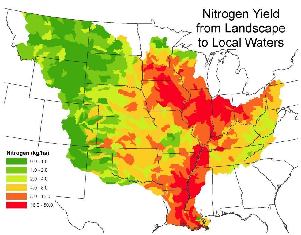
1 Nutrient Delivery from the Mississippi River to the Gulf of Mexico and Effects of Cropland Conservation Mike White, Jeff Arnold, Lee Norfleet, Santhi Chinnasamy, and Mauro DiLuzio USDA-ARS Grassland, Soil and Water Research Laboratory USDA-NRCS Texas AgriLife Blackland Research Center


2 Justify US conservation expenditures (about 2 billion annually) Demonstrate water quality improvements due to conservation Uses SWAT and APEX
 1,300 in MRB Streams/rivers Reservoirs SWAT Routing Delivered Load")
3 Public Data SWAT Model Complete Model Survey Data APEX Crop Field APEX Cultivated fields 18,000 farmer surveys SWAT All other landuses 2,200 Subbasins (8 digit HUC) 1,300 in MRB Streams/rivers Reservoirs SWAT Routing Delivered Load Prediction

")
4 Constituents Flow Sediment Nitrogen (TN, NO 3, NH 3, TKN) Phosphorus (TP, SP) Calibration 38 Sites
5 CEAP uses a custom SWAT Incompatible with existing software and interfaces Using expert knowledge Rules based calibration Automate manual calibration decision process Supports about 30 parameters Hydrology Matches measured data Flow, sediment, nutrients loads at fixed sites Considers other knowledge Sediment losses by landuse type Reach delivery ratios (aggregation/degradation) Reservoir trapping typical Reach sediment delivery low Increase SPCON Upland sediment yield too low Increase HRU slope Surface runoff too high Reduce curve number
6

7 Validation based on multiple indicators that a model represents the system Comparison to monitoring data 17 sites NSE Relative Error Comparison with SPARROW 1,300 locations R 2 >0.95 Comparison based on literature values and expert knowledge Export coefficients SWAT Check Delivery ratio analysis and inspection

8


9 Identical Farms Local Local Load Load 100 kg 100 kg 100 kg Differing Position 50 km 500 km Reservoir 50 km Delivered Load 90 kg Gulf 65 kg 25 kg 9
10 10
11
12


13 No-Practice scenario Without the conservation practices reported by the CEAP survey Not a worst case scenario No landowner conservation ethic
14 Scenario Total Nitrogen (Million Kg/yr) Load From All Sources Delivered to the Gulf Total Phosphorus (Million kg/yr) No Conservation Practices 1, Current Conservation Condition 1, Reduction due to Conservation 18% 20%
15

16 Increase spatial resolution 2,200 Subbasins (HUC 8) to 60,000 (HUC 10-12) 75,000 HRUs to 2 million HRUs Expand calibration data 750 Sites More detailed data SSURGO Soils 15,000+ Weather gages


17 Break the Basin into submodels Build Dependency Tree Some are independent Others depend on flow from upstream Transfer water from one to another via saved hydrographs Execute models individually Asynchronously when dependences are satisfied Run on many processors or computers at once
18 Not Ready Ready Processing Finished Start Gulf
19 Not Ready Ready Processing Finished Cycle #0.5 Identify models without unmet dependencies Gulf

20 Not Ready Ready Processing Finished Cycle #1 Select 4 models to run Gulf
21 Not Ready Ready Processing Finished Cycle #2 Identify models without unmet dependencies and Select another 4 models to run Gulf
22 Not Ready Ready Processing Finished Cycle #3 Identify models without unmet dependencies and Select another 4 models to run Gulf
23 Not Ready Ready Processing Finished Cycle #4 Identify models without unmet dependencies and Select another 4 models to run Gulf
24 Not Ready Ready Processing Finished Cycle #5 Identify models without unmet dependencies and Select another 4 models to run Gulf
25 Not Ready Ready Processing Finished Cycle #6 Identify models without unmet dependencies and Select available models to run Gulf Grassland, Soil and Water Research Laboratory, 25 Temple, TX
26 Not Ready Ready Processing Finished Cycle #7 Identify models without unmet dependencies and Select available models to run Gulf
27 Not Ready Ready Processing Finished Cycle #8 Identify models without unmet dependencies and Select available models to run Gulf

28 Not Ready Ready Processing Finished Finished 23 Subbasins processed in 8 cycles Gain = 23/8 = 280% Gulf


29 Manager Server Node Client Model Repository Network Share SWATHUC

30 Windows Cluster 150 cores GHZ 60,000 HRU model run for 37 Years takes 6 min on 8 nodes

31
MODULE 8 LECTURE NOTES 2 REMOTE SENSING APPLICATIONS IN RAINFALL-RUNOFF MODELLING
 MODULE 8 LECTURE NOTES 2 REMOTE SENSING APPLICATIONS IN RAINFALL-RUNOFF MODELLING 1. Introduction The most common application of the remote sensing techniques in the rainfall-runoff studies is the estimation
Hydrologic and Water Quality Modeling for the Missouri River Basin (MORB)
") 2016 International SWAT Conference in Beijing, China Hydrologic and Water Quality Modeling for the Missouri River Basin (MORB) Zhonglong Zhang, PhD, PE, May Wu, PhD Courtesy of USACE Outline Missouri River
2016 International SWAT Conference in Beijing, China Hydrologic and Water Quality Modeling for the Missouri River Basin (MORB) Zhonglong Zhang, PhD, PE, May Wu, PhD Courtesy of USACE Outline Missouri River
Hydrologic Modelling of the Upper Malaprabha Catchment using ArcView SWAT
 Hydrologic Modelling of the Upper Malaprabha Catchment using ArcView SWAT Technical briefs are short summaries of the models used in the project aimed at nontechnical readers. The aim of the PES India
SWAT2009_LUC: A TOOL TO ACTIVATE LAND USE CHANGE MODULE IN SWAT 2009
 SWAT2009_LUC: A TOOL TO ACTIVATE LAND USE CHANGE MODULE IN SWAT 2009 Naresh Pai Dharmendra Saraswat Department of Biological & Agricultural Engineering Presented at: BACKGROUND Simulate impact of soil,
Assessing Spatial and Temporal Distribution of Sediment, Nitrogen and Phosphorous Loading in the Missouri River Basin (MORB)
") Assessing Spatial and Temporal Distribution of Sediment, Nitrogen and Phosphorous Loading in the Missouri River Basin (MORB) Zhonglong Zhang, PhD, PE, May Wu, PhD LimnoTech, Environmental Laboratory, ERDC,
Assessing Spatial and Temporal Distribution of Sediment, Nitrogen and Phosphorous Loading in the Missouri River Basin (MORB) Zhonglong Zhang, PhD, PE, May Wu, PhD LimnoTech, Environmental Laboratory, ERDC,
Detroit 516 Activities
 Detroit 516 Activities Dam Capacity Study Sediment Workshop in Traverse City START 2.0 Saginaw River Study Dam Capacity Study A progress report Outline Study Objective (Why are we doing this?) Reservoir
Modeling Upland and Channel Sources of Sediment in the Le Sueur River Watershed, Minnesota
 Modeling Upland and Channel Sources of Sediment in the Le Sueur River Watershed, Minnesota Solomon Folle and David Mulla Department of Soil, Water and Climate University of Minnesota August 6, 2009 5 th
EXAMPLE WATERSHED CONFIGURATIONS
 APPENDIX B EXAMPLE WATERSHED CONFIGURATIONS The watershed configuration file defines the spatial relationship of objects within the watershed. The three techniques used to subdivide a watershed are the
Application of an Enhanced, Fine-Scale SWAT Model to Target Land Management Practices for Maximizing Pollutant Reduction and Conservation Benefits
 Application of an Enhanced, Fine-Scale SWAT Model to Target Land Management Practices for Maximizing Pollutant Reduction and Conservation Benefits Amanda Flynn, Todd Redder, Joe DePinto, Derek Schlea Brian
Roger Andy Gaines, Research Civil Engineer, PhD, P.E.
 Roger Andy Gaines, Research Civil Engineer, PhD, P.E. Research Civil Engineer/Regional Technical Specialist Memphis District August 24, 2010 Objectives Where we have been (recap of situation and what s
WaterBase: SWAT in an Open Source GIS
 WaterBase: SWAT in an Open Source GIS C. George 1 and L.F. Leon*,2 The Open Hydrology Journal, 2008, 2, 1-6 1 1 International Institute for Software Technology, United Nations University, Macao, China
Evaluation of the two stage ditch as a best management practice. A. Hodaj, L.C. Bowling, C. Raj, I. Chaubey
 Evaluation of the two stage ditch as a best management practice A. Hodaj, L.C. Bowling, C. Raj, I. Chaubey Two-stage ditch: Stage 1 : main channel Stage 2 : flood plain bench Traditional ditch Twostage
Streamflow, Sediment, and Nutrient Simulation of the Bitterroot Watershed using SWAT
 Streamflow, Sediment, and Nutrient Simulation of the Bitterroot Watershed using SWAT by Dr. Michael Van Liew Montana Department of Environmental Quality Helena, Montana, USA Site Map of SWAT Watersheds
Current and Future Plans. R. Srinivasan
 Current and Future Plans R. Srinivasan Contents 1 The ArcSWAT Interface 2 VizSWAT: Output Visualization 3 User online support 4 MapWindows SWAT interface 5 ArcGIS SWAT/APEX interfaces 6 Radar Rainfall
Nina Omani, Raghavan Srinivasan, and Taesoo Lee. Spatial Sciences Laboratory, Texas A&M University
 Nina Omani, Raghavan Srinivasan, and Taesoo Lee Spatial Sciences Laboratory, Texas A&M University This project was initiated to develop and apply the SWAT model to two Texas estuaries in order to estimate
David Coffman, M.S. & Becky Griffith, Ph.D. July 31, 2013
 David Coffman, M.S. & Becky Griffith, Ph.D. July 31, 2013 Texas River Basins Sulphur River Watershed Sediment Sulphur River Watershed Sediment Sulphur River Watershed Sediment Sulphur River Watershed
Problems and Solutions in Applying SWAT in the Upper Midwest USA
 Problems and Solutions in Applying SWAT in the Upper Midwest USA J.E. Almendinger 1, M.S. Murphy 2 1 Senior Scientist, St. Croix Watershed Research Station, Science Museum of Minnesota, Marine on St. Croix,
CWMS Modeling for Real-Time Water Management
 Hydrologic Engineering Center Training Course on CWMS Modeling for Real-Time Water Management August 2018 Davis, California The Corps Water Management System (CWMS) is a software and hardware system to
International Journal of Scientific & Engineering Research, Volume 6, Issue 8, August ISSN
 International Journal of Scientific & Engineering Research, Volume 6, Issue 8, August-2015 1670 DEM Processing for Watershed Delineation using QSWAT M.V.S.S. Giridhar 1, Ramaraju Anirudh 2, G. Sreenivasa
Liliana Pagliero June, 15 th 2011
 Liliana Pagliero liliana.pagliero@jrc.ec.europa.eu June, 15 th 2011 2/18 SWAT MODELLING AT PAN EUROPEAN SCALE: THE DANUBE BASIN PILOT STUDY Introduction The Danube Model Available databases Model set up
Introduction to the new modular SWAT code: The input file structure explained using the example of the Little River Experimental Watershed, USA
 Introduction to the new modular SWAT code: The input file structure explained using the example of the Little River Experimental Watershed, USA Katrin Bieger and Jeffrey G. Arnold 2014 International SWAT
A Post Processing Tool to Assess Sediment and Nutrient Source Allocations from SWAT Simulations
 A Post Processing Tool to Assess Sediment and Nutrient Source Allocations from SWAT Simulations Michael Van Liew William Puknat Montana Department of Environmental Quality Helena, Montana, USA PROBLEM:
Technical Memorandum FINAL
 Technical Memorandum FINAL To: Project File A previous effort to develop and calibrate a Soil and Water Assessment Tool (SWAT) watershed model for the Cedar River basin included a limited representation
Influence of the Major Drainages to the Mississippi River and Implications for System Level Management
 Influence of the Major Drainages to the Mississippi River and Implications for System Level Management Brian M. Vosburg Geologist Louisiana Coastal Protection and Restoration Authority brian.vosburg@la.gov
Assessment of solid load and siltation potential of dams reservoirs in the High Atlas of Marrakech (Moorcco) using SWAT Model
 using SWAT Model") Assessment of solid load and siltation potential of dams reservoirs in the High Atlas of Marrakech (Moorcco) using SWAT Model Amal Markhi: Phd Student Supervisor: Pr :N.Laftrouhi Contextualization Facing
Assessment of solid load and siltation potential of dams reservoirs in the High Atlas of Marrakech (Moorcco) using SWAT Model Amal Markhi: Phd Student Supervisor: Pr :N.Laftrouhi Contextualization Facing
Use of SWAT to Scale Sediment Delivery from Field to Watershed in an Agricultural Landscape with Depressions
 Use of SWAT to Scale Sediment Delivery from Field to Watershed in an Agricultural Landscape with Depressions James E. Almendinger St. Croix Watershed Research Station, Science Museum of Minnesota Marylee
Simulation of sedimentation rates using the SWAT model A case study of the Tarbela Dam, Upper Indus Basin
 Simulation of sedimentation rates using the SWAT model A case study of the Tarbela Dam, Upper Indus Basin Ahammad, H. I 1., Crosato A 2,3., Maskey, S 2., Masih, I 2,*, McClain, M 2. 1 Punjab Irrigation
Eagle Mountain Watershed: Calibration, Validation, and Best Management
 COLLEGE OF AGRICULTURE AND LIFE SCIENCES TR-408 2011 Eagle Mountain Watershed: Calibration, Validation, and Best Management By Taesoo Lee, Balaji Narasimhan, and Raghavan Srinivasan Spatial Science Laboratory,
StreamStats: Delivering Streamflow Information to the Public. By Kernell Ries
 StreamStats: Delivering Streamflow Information to the Public By Kernell Ries U.S. Department of the Interior U.S. Geological Survey MD-DE-DC District 410-238-4317 kries@usgs.gov StreamStats Web Application
The Effect of Land Use Change to Land Erosion and Sediment Transported on The Cacthment Area of Mrica Reservoir
 The Effect of Land Use Change to Land Erosion and Sediment Transported on The Cacthment Area of Mrica Reservoir Lukman Hidayat 1, Putu Sudira 2, Sahid Susanto 2, and Rachmad Jayadi 3 1 Agricultural Technology
Workshop: Build a Basic HEC-HMS Model from Scratch
 Workshop: Build a Basic HEC-HMS Model from Scratch This workshop is designed to help new users of HEC-HMS learn how to apply the software. Not all the capabilities in HEC-HMS are demonstrated in the workshop
Effect of GIS data quality on small watershed stream flow and sediment simulations
 HYDROLOGICAL PROCESSES Hydrol. Process. 19, 629 650 (2005) Published online in Wiley InterScience (www.interscience.wiley.com). DOI: 10.1002/hyp.5612 Effect of GIS data quality on small watershed stream
Modelling Runoff with Satellite Data. Nyandwaro Gilbert Nyageikaro Patrick Willems Joel Kibiiy
 Modelling Runoff with Satellite Data Nyandwaro Gilbert Nyageikaro Patrick Willems Joel Kibiiy 1 Outline Background information SWAT model development The model sensitivity analysis and calibration Calibration
Towards a process-oriented HRU-concept in SWAT: Catchment-related control on baseflow and storage of landscape units in medium to large river basins.
 Towards a process-oriented HRU-concept in SWAT: Catchment-related control on baseflow and storage of landscape units in medium to large river basins. Martin Volk 1), J.G. Arnold 2), P.M. Allen 3), Pei-Yu
Great Lakes Online Watershed Interface W. Elliot, Research Engineer USDA Forest Service Rocky Mountain Research Station, Moscow, ID March, 2016
 Great Lakes Online Watershed Interface W. Elliot, Research Engineer USDA Forest Service Rocky Mountain Research Station, Moscow, ID March, 2016 Guidelines for using the Web WEPP Watershed Tool to Support
June 2018 WORKSHOP SECTION 2 MANUAL: RUNNING PTMAPP-DESKTOP AN INNOVATIVE SOLUTION BY:
 June 2018 WORKSHOP SECTION 2 MANUAL: RUNNING PTMAPP-DESKTOP AN INNOVATIVE SOLUTION BY: TABLE OF CONTENTS 1 PURPOSE... 3 2 SET UP DATA PATHS... 4 2.1 BASE DATA SETUP... 4 3 INGEST DATA... 6 3.1 CLIP WATERSHED...
Figure 0-18: Dendrogeomorphic analysis of streambank erosion and floodplain deposition (from Noe and others, 2015a)
") Appendix 9A: Stream to River During the development of the Phase 6 Watershed Model, multiple methods for determining coefficients were often attempted. In some cases, the methods are averaged or otherwise
Appendix 9A: Stream to River During the development of the Phase 6 Watershed Model, multiple methods for determining coefficients were often attempted. In some cases, the methods are averaged or otherwise
Chesapeake Bay Remote Sensing Pilot Executive Briefing
 Chesapeake Bay Remote Sensing Pilot Executive Briefing Introduction In his Executive Order 13506 in May 2009, President Obama stated The Chesapeake Bay is a national treasure constituting the largest estuary
Modeling the Effects of Climate and Land Cover Change in the Stoney Brook Subbasin of the St. Louis River Watershed
 Modeling the Effects of Climate and Land Cover Change in the Stoney Brook Subbasin of the St. Louis River Watershed Joe Johnson and Jesse Pruette 214 NASA Research Internship Geospatial Technologies Program
Lecture 3. Data Sources for GIS in Water Resources
 Lecture 3 Data Sources for GIS in Water Resources GIS in Water Resources Spring 2015 http://www.data.gov/ 1 USGS GIS data for Water http://water.usgs.gov/maps.html Watersheds of the US 2-digit water resource
Modeling Vegetative Buffer Performance Considering Topographic Data Accuracy
 University of Nebraska - Lincoln DigitalCommons@University of Nebraska - Lincoln USDA Forest Service / UNL Faculty Publications U.S. Department of Agriculture: Forest Service -- National Agroforestry Center
Reducing Nitrogen Removal Uncertainty for Operation of Mississippi River Sediment Diversions: Nitrate Reduction Rates In Turbulent Flow Conditions
 Reducing Nitrogen Removal Uncertainty for Operation of Mississippi River Sediment Diversions: Nitrate Reduction Rates In Turbulent Flow Conditions Nia R. Hurst, John R. White, Kehui Xu, and MingCheng Ren
Micro Watershed Modeling in India Using GIS Technologies and Agricultural Policy Environmental Extender (APEX) Model. A Case Study
 Model. A Case Study") Micro Watershed Modeling in India Using GIS Technologies and Agricultural Policy Environmental Extender (APEX) Model. A Case Study C.N. Tripathi 1 and A K Gosain 2 1 Department of Environmental Engineering,
Micro Watershed Modeling in India Using GIS Technologies and Agricultural Policy Environmental Extender (APEX) Model. A Case Study C.N. Tripathi 1 and A K Gosain 2 1 Department of Environmental Engineering,
Web (Java, ArcGIS Server [WebADF, flex, silverlight]) Mobile (ArcGIS Mobile, ArcPad, Windows Mobile) Deskt
![Web (Java, ArcGIS Server [WebADF, flex, silverlight]) Mobile (ArcGIS Mobile, ArcPad, Windows Mobile) Deskt](/thumbs/96/129284052.jpg "Web (Java, ArcGIS Server [WebADF, flex, silverlight]) Mobile (ArcGIS Mobile, ArcPad, Windows Mobile) Deskt") GIS Services company in Lincoln, NE Custom GIS database design and build (for local, county, state and private corporations) Custom (ESRI and non-esri) application design and build in Java, C++, C#,.Net
GIS Services company in Lincoln, NE Custom GIS database design and build (for local, county, state and private corporations) Custom (ESRI and non-esri) application design and build in Java, C++, C#,.Net
Measuring Streambank Erosion Bank Profiles to more Robustly Estimate Recession Rates and Calibration of the AnnAGNPS-CEAP Model
 Measuring Streambank Erosion Bank Profiles to more Robustly Estimate Recession Rates and Calibration of the AnnAGNPS-CEAP Model Clare Prestwich, P.E. 1 & W. Barry Southerland, Ph.D. 2 Water Quality and
Hydrologic Response of SWAT to Single Site and Multi- Site Daily Rainfall Generation Models
 Hydrologic Response of SWAT to Single Site and Multi- Site Daily Rainfall Generation Models 1 Watson, B.M., 2 R. Srikanthan, 1 S. Selvalingam, and 1 M. Ghafouri 1 School of Engineering and Technology,
SEDIMENT INFLOW ESTIMATION AND MAPPING ITS SPATIAL DISTRIBUTION AT SUB-BASIN SCALE: THE CASE OF TENDAHO DAM, AFAR REGIONAL STATE, ETHIOPIA
 Ethiopian Journal of Environmental Studies & Management 10(3): 315 339, 2017. ISSN:1998-0507 doi: https://dx.doi.org/10.4314/ejesm.v10i3.4 Submitted: December 10, 2016 Accepted: April 08, 2017 SEDIMENT
Appendix D. Model Setup, Calibration, and Validation
 . Model Setup, Calibration, and Validation Lower Grand River Watershed TMDL January 1 1. Model Selection and Setup The Loading Simulation Program in C++ (LSPC) was selected to address the modeling needs
Lake Tahoe Watershed Model. Lessons Learned through the Model Development Process
 Lake Tahoe Watershed Model Lessons Learned through the Model Development Process Presentation Outline Discussion of Project Objectives Model Configuration/Special Considerations Data and Research Integration
Simulation of hydrologic and water quality processes in watershed systems using linked SWAT-MODFLOW-RT3D model
 Simulation of hydrologic and water quality processes in watershed systems using linked model Ryan Bailey, Assistant Professor Xiaolu Wei, PhD student Rosemary Records, PhD student Mazdak Arabi, Associate
Analyzing spatial and temporal variation of water balance components in La Vi catchment, Binh Dinh province, Vietnam
 Analyzing spatial and temporal variation of water balance components in La Vi catchment, Binh Dinh province, Vietnam Nguyen Duy Liem, Vo Ngoc Quynh Tram, Nguyen Le Tan Dat, Nguyen Kim Loi Nong Lam University-
Little Swan Lake. Dam Inspection & Siltation Study Prepared By: William Klingner, P.E., CFM October 28, 2018
 Little Swan Lake Dam Inspection & Siltation Study Prepared By: William Klingner, P.E., CFM October 28, 2018 Agenda Little Swan Lake Dam Inspection Theoretical Little Swan Lake Siltation Rate Calculations
Development of Webbased. Tool for Tennessee
 Development of Webbased Farm Mapping Tool for Tennessee Southern Region Water Quality Conference, Oct. 24 2005 Forbes Walker and Alan Jolly Biosystems Engineering and SOIL SCIENCE Nutrient Management Planning
Nitrogen and phosphorus dynamics in restored riverine floodplains in intensively managed watersheds
 Nitrogen and phosphorus dynamics in restored riverine floodplains in intensively managed watersheds Sara McMillan 1, Alex Johnson 1, Celena Alford 1, Greg Noe 2, Venkatesh Merwade 1, Sayan Dey, 1 Siddharth
Challenges in Calibrating a Large Watershed Model with Varying Hydrogeologic Conditions
 Challenges in Calibrating a Large Watershed Model with Varying Hydrogeologic Conditions Presented by Johnathan R. Bumgarner, P.G., Celine A.L. Louwers, & Monica P. Suarez, P.E. In cooperation with the
Supplementary Material: A Guide for Using the Coupled SWAT MODSIM (SM) Model
 Model") Supplementary Material: A Guide for Using the Coupled SWAT MODSIM (SM) Model Saeid Ashraf Vaghefi (saeedashrafv@gmail.com) The coupled SWAT MODSIM (SM) is a tool that can be used in integrated watershed
Supplementary Material: A Guide for Using the Coupled SWAT MODSIM (SM) Model Saeid Ashraf Vaghefi (saeedashrafv@gmail.com) The coupled SWAT MODSIM (SM) is a tool that can be used in integrated watershed
KINEROS2/AGWA. Fig. 1. Schematic view (Woolhiser et al., 1990).
.") KINEROS2/AGWA Introduction Kineros2 (KINematic runoff and EROSion) (K2) model was originated at the USDA-ARS in late 1960s and released until 1990 (Smith et al., 1995; Woolhiser et al., 1990). The spatial
KINEROS2/AGWA Introduction Kineros2 (KINematic runoff and EROSion) (K2) model was originated at the USDA-ARS in late 1960s and released until 1990 (Smith et al., 1995; Woolhiser et al., 1990). The spatial
Modelling vulnerability of coastal ecosystems to land-based mining pollution: a case study from Brazil
 Modelling vulnerability of coastal ecosystems to land-based mining pollution: a case study from Brazil By Rafael A. Magris, Natalie C. Ban, Jose Monteiro Mining in Brazil is a significant primary industry
Sediment and nutrient transport and storage along the urban stream corridor
 Sediment and nutrient transport and storage along the urban stream corridor Greg Noe, Cliff Hupp, Ed Schenk, Jackie Batson, Nancy Rybicki, Allen Gellis What is the role of floodplains everywhere? Noe 2013,
Application of SWAT Model to Estimate the Runoff and Sediment Load from the Right Bank Valleys of Mosul Dam Reservoir
 Application of SWAT Model to Estimate the Runoff and Sediment Load from the Right Bank Valleys of Mosul Dam Reservoir Dr Mohammad Ezeel Deen Prof. Nadhir Al-Ansari Prof Sven Knutsson Figure 1.Map of Iraq
Urban Tree Canopy Assessment Purcellville, Virginia
 GLOBAL ECOSYSTEM CENTER www.systemecology.org Urban Tree Canopy Assessment Purcellville, Virginia Table of Contents 1. Project Background 2. Project Goal 3. Assessment Procedure 4. Economic Benefits 5.
INTRODUCTION TO HEC-HMS
 INTRODUCTION TO HEC-HMS Hydrologic Engineering Center- Hydrologic Modeling System US Army Corps of Engineers Hydrologic Engineering Center HEC-HMS Uses Schematics Enter properties: watershed, rivers (reaches),
Changing Hydrology under a Changing Climate for a Coastal Plain Watershed
 Changing Hydrology under a Changing Climate for a Coastal Plain Watershed David Bosch USDA-ARS, Tifton, GA Jeff Arnold ARS Temple, TX and Peter Allen Baylor University, TX SEWRU Objectives 1. Project changes
1/18/2016. Council Study. Model Set Up and Results of Hydrologic Assessment/Modeling Team BACKGROUND
 Council Study Model Set Up and Results of Hydrologic Assessment/Modeling Team BACKGROUND 1 Role of Modeling Team Conduct the hydrologic, hydraulic, sediment transport, and water quality modeling required
GIS BASED HYDROLOGICAL MODELLING FOR CLIMATE CHANGE IMPACT ASSESSMENT. Dr. Amardeep Singh, MoWR Prof. A. K. Gosain, IIT Delhi
 GIS BASED HYDROLOGICAL MODELLING FOR CLIMATE CHANGE IMPACT ASSESSMENT Dr. Amardeep Singh, MoWR Prof. A. K. Gosain, IIT Delhi Model Description SWAT (Soil and Water Assessment Tool) Conceptual, distributed,
Near Real-Time Runoff Estimation Using Spatially Distributed Radar Rainfall Data. Jennifer Hadley 22 April 2003
 Near Real-Time Runoff Estimation Using Spatially Distributed Radar Rainfall Data Jennifer Hadley 22 April 2003 Introduction Water availability has become a major issue in Texas in the last several years,
4.0 WRIGHT PATMAN LAKE YIELD SCENARIOS
 Watershed Overview 4.0 WRIGHT PATMAN LAKE YIELD SCENARIOS As currently operated, Wright Patman Lake provides over 2.5 million acre-feet of storage for floodwaters. Consistent with that mission, water captured
Nitrogen (and phosphorus?) surface water retention in the Baltic Sea drainage basin
 surface water retention in the Baltic Sea drainage basin") Nitrogen (and phosphorus?) surface water retention in the Baltic Sea drainage basin Per Stålnacke Bioforsk per.staalnacke@bioforsk.no Retention processes (Howarth et al. 1996): storage in catchment biomass
Nitrogen (and phosphorus?) surface water retention in the Baltic Sea drainage basin Per Stålnacke Bioforsk per.staalnacke@bioforsk.no Retention processes (Howarth et al. 1996): storage in catchment biomass
Great Lakes Dam Capacity Study
 Great Lakes Dam Capacity Study Project Team: USACE, Detroit District Wayne State University, Detroit, Michigan Great Lakes Environmental Center, Traverse City, Michigan BUILDING STRONG Study Objectives
Assessing the Hydrologic Implications of Land Use Change for the Upper Neuse River Basin. Kelly Conaghan Dr. Dean Urban, Advisor May 2010
 Assessing the Hydrologic Implications of Land Use Change for the Upper Neuse River Basin By Kelly Conaghan Dr. Dean Urban, Advisor May 2010 Masters project submitted in partial fulfillment of the requirements
Spatial representation of evapotranspiration in the Mara basin: results derived from the SWAT model and remote sensing products
 Spatial representation of evapotranspiration in the Mara basin: results derived from the SWAT model and remote sensing products Alemayehu, T 1., van Griensven, A. 1,2, Kilonzo, F. 1,2, and Bauwens, W.
EXECUTIVE SUMMARY MANAGEMENT OF NONPOINT SOURCE POLLUTION AN INTEGRATIVE GIS-ANNAGNPS MODEL SEPTEMBER 2003
 EXECUTIVE SUMMARY MANAGEMENT OF NONPOINT SOURCE POLLUTION AN INTEGRATIVE GIS-ANNAGNPS MODEL SEPTEMBER 2003 CENTRAL PLAINS CENTER FOR BIOASSESSMENT KANSAS BIOLOGICAL SURVEY AND KANSAS GEOLOGICAL SURVEY
Transactions on Information and Communications Technologies vol 18, 1998 WIT Press, ISSN
 STREAM, spatial tools for river basins, environment and analysis of management options Menno Schepel Resource Analysis, Zuiderstraat 110, 2611 SJDelft, the Netherlands; e-mail: menno.schepel@resource.nl
Model Calibration and Forecast Error for NFIE-Hydro
 Corey Van Dyk C E 397 Flood Forecasting 5/8/15 Model Calibration and Forecast Error for NFIE-Hydro Introduction The forecasting component of the National Flood Interoperability Experiment (NFIE), like
Civil Engineering 394K: Topic 3 Geographic Information Systems (GIS) in Water Resources Engineering FALL 2014
 in Water Resources Engineering FALL 2014") Civil Engineering 394K: Topic 3 Geographic Information Systems (GIS) in Water Resources Engineering TERM PROJECT REPORT Reinvestigation of the Halloween Flood and Hydrologic Modeling of the Onion Creek
Civil Engineering 394K: Topic 3 Geographic Information Systems (GIS) in Water Resources Engineering TERM PROJECT REPORT Reinvestigation of the Halloween Flood and Hydrologic Modeling of the Onion Creek
Watershed Conservation Management Planning Using the Integrated Field & Channel Technology of AnnAGNPS & CONCEPTS
 Watershed Conservation Management Planning Using the Integrated Field & Channel Technology of AnnAGNPS & CONCEPTS Eddy Langendoen Ron Bingner USDA-ARS National Sedimentation Laboratory, Oxford, Mississippi
Impact of different types of meteorological data inputs on predicted hydrological and erosive responses to projected land use change
 Impact of different types of meteorological data inputs on predicted hydrological and erosive responses to projected land use change Suman Bhattacharyya 1 & Joy Sanyal * 1 2 1 Department of Geography,
George Mason University Department of Civil, Environmental and Infrastructure Engineering
 George Mason University Department of Civil, Environmental and Infrastructure Engineering Dr. Celso Ferreira Prepared by Lora Baumgartner December 2015 Revised by Brian Ross July 2016 Exercise Topic: Getting
12 SWAT USER S MANUAL, VERSION 98.1
 12 SWAT USER S MANUAL, VERSION 98.1 CANOPY STORAGE. Canopy storage is the water intercepted by vegetative surfaces (the canopy) where it is held and made available for evaporation. When using the curve
Development of the Hydrologic Model
 Kick-off meeting on enhancing hydrological data management and exchange procedures Water and Climate Adaptation Plan (WATCAP) for Sava River Basin Development of the Hydrologic Model David Heywood Team
Technical Memorandum No
 Pajaro River Watershed Study in association with Technical Memorandum No. 1.2.10 Task: Evaluation of Four Watershed Conditions - Sediment To: PRWFPA Staff Working Group Prepared by: Gregory Morris and
Mid-term Operations Probabilistic Model of the Colorado River Basin
 Mid-term Operations Probabilistic Model of the Colorado River Basin Tony Powell Precision Water Resources Engineering Daniel Bunk Reclamation, Lower Colorado Region RiverWare User Group Meeting NCAR/UCAR
February Prioritize, Target, Measure Application (PTMApp) Desktop Toolbar User s Guide
 Desktop Toolbar User s Guide") February 2018 Prioritize, Target, Measure Application (PTMApp) Desktop Toolbar User s Guide 2 1 TABLE OF CONTENTS 2 Introduction... 5 2.1 Overview... 5 2.2 General Information... 5 3 Input Data Requirements...
February 2018 Prioritize, Target, Measure Application (PTMApp) Desktop Toolbar User s Guide 2 1 TABLE OF CONTENTS 2 Introduction... 5 2.1 Overview... 5 2.2 General Information... 5 3 Input Data Requirements...
Investigation of landslide based on high performance and cloud-enabled geocomputation
 Investigation of landslide based on high performance and cloud-enabled geocomputation Jun Liu 1, Shuguang Liu 2,*, Qiming Zhou 3, Jing Qian 1 1 Shenzhen Institutes of Advanced Technology, Chinese Academy
SPECIFIC DEGRADATION AND RESERVOIR SEDIMENTATION. By Renee Vandermause & Chun-Yao Yang
 SPECIFIC DEGRADATION AND RESERVOIR SEDIMENTATION By Renee Vandermause & Chun-Yao Yang Outline Sediment Degradation - Erosion vs Sediment Yield - Sediment Yield - Methods for estimation - Defining Sediment
Introduction to the Agricultural Conservation Planning Framework (ACPF)
") Introduction to the Agricultural Conservation Planning Framework (ACPF) Mark Tomer David James Sarah Porter Jessy Van Horn USDA/ARS National Laboratory for Agriculture and the Environment Ames, Iowa What
Introduction to the Agricultural Conservation Planning Framework (ACPF) Mark Tomer David James Sarah Porter Jessy Van Horn USDA/ARS National Laboratory for Agriculture and the Environment Ames, Iowa What
Application of SWAT Model for Mountainous Catchment
 LARS 2007 Catchment and Lake Research Application of SWAT Model for Mountainous Catchment Birhanu, B.Z, Ndomba, P.M and Mtalo, F.W. University of Dar es Salaam, Water Resources Engineering Abstract A GIS
1. Introduction. 1 Corresponding author,
 Effect of Land Use Changes on Sediment Load in the Zagbo River Catchment in Southern Benin Olanrewaju Lawal 1, Thomas Gaiser, Karl Stahr Institute for Soil Science and Land Evaluation, University of Hohenheim,
CONVERTING A NEXRAD MAP TO A FLOODPLAIN MAP. Oscar Robayo, Tim Whiteaker, and David Maidment*
 CONVERTING A NEXRAD MAP TO A FLOODPLAIN MAP Oscar Robayo, Tim Whiteaker, and David Maidment* ABSTRACT: Using ArcGIS 9.0 ArcObjects and the new ModelBuilder environment, a methodology for converting a NEXRAD
Development of a GIS Interface for WEPP Model Application to Great Lakes Forested Watersheds
 Development of a GIS Interface for WEPP Model Application to Great Lakes Forested Watersheds J.R. Frankenberger 1, S. Dun 2, D.C. Flanagan 1, J.Q. Wu 2, W.J. Elliot 3 1 USDA-ARS, West Lafayette, IN 2 Washington
Geospatial Data, Services, and Products. National Surveying, mapping and geospatial conference
 Geospatial Data, Services, and Products Federal Programs -- USDA NRCS National Surveying, mapping and geospatial conference March 15, 2016 NRCS Applications using Geosaptial Products & Services Field
How to integrate wetland processes in river basin modeling? A West African case study
 How to integrate wetland processes in river basin modeling? A West African case study stefan.liersch@pik-potsdam.de fred.hattermann@pik-potsdam.de June 2011 Outline Why is an inundation module required?
Two-Step Calibration Method for SWAT
 SWAT 2005 Zurich, Switzerland July 14 th, 2005 Two-Step Calibration Method for SWAT Francisco Olivera, Ph.D. Assistant Professor Huidae Cho Graduate Student Department of Civil Engineering Texas A&M University
GLACIER AND SNOWMELT MODELLING USING SWAT: GANGA BASIN CASE STUDY. INRM Consultants Pvt. Ltd.
 GLACIER AND SNOWMELT MODELLING USING SWAT: GANGA BASIN CASE STUDY INRM Consultants Pvt. Ltd. Introduction Snowmelt Runoff contribution in the Himalayan Rivers Estimation of Average contribution of Snowmelt
GEOL 1121 Earth Processes and Environments
 GEOL 1121 Earth Processes and Environments Wondwosen Seyoum Department of Geology University of Georgia e-mail: seyoum@uga.edu G/G Bldg., Rm. No. 122 Seyoum, 2015 Chapter 6 Streams and Flooding Seyoum,
Evaluation of the SWAT Model Setup Process Through A Case Study in Roxo Catchment, Portugal
 Evaluation of the SWAT Model Setup Process Through A Case Study in Roxo Catchment, Portugal Mustafa Gökmen Master Degree in on Geo-information and Earth Observation for Integrated Catchment and Water Resources
Designing a Dam for Blockhouse Ranch. Haley Born
 Designing a Dam for Blockhouse Ranch Haley Born CE 394K GIS in Water Resources Term Paper Fall 2011 Table of Contents Introduction... 1 Data Sources... 2 Precipitation Data... 2 Elevation Data... 3 Geographic
An Overview of Operations at the West Gulf River Forecast Center Gregory Waller Service Coordination Hydrologist NWS - West Gulf River Forecast Center
 National Weather Service West Gulf River Forecast Center An Overview of Operations at the West Gulf River Forecast Center Gregory Waller Service Coordination Hydrologist NWS - West Gulf River Forecast
Uncertainty in the SWAT Model Simulations due to Different Spatial Resolution of Gridded Precipitation Data
 Uncertainty in the SWAT Model Simulations due to Different Spatial Resolution of Gridded Precipitation Data Vamsi Krishna Vema 1, Jobin Thomas 2, Jayaprathiga Mahalingam 1, P. Athira 4, Cicily Kurian 1,
Changes in Texas Ecoregions
 Comment On Lesson Changes in Texas Ecoregions The state of Texas can be divided into 10 distinct areas based on unique combinations of vegetation, topography, landforms, wildlife, soil, rock, climate,