Tylr Naprstek Water Modeling Coordinator
|
|
|
- Meghan Robertson
- 5 years ago
- Views:
Transcription


1 Tylr Naprstek Water Modeling Coordinator
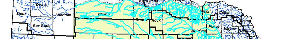


2 Focus development of Regional GW model for 2 basins: Loup, Elkhorn
3 Niobrara R to Platte R Headwaters of Loup/Elkhorn to Columbus/Norfolk
4 NebrGISgeology.asp Encompasses most of the sandhills region Unique to Nebraska Abundant Aquifer (1,200 ft) High recharge potential
5 Elkhorn & Loup originate and end in Nebraska No State Compacts Landlocked NRDs In-Stream Flow Requirement Appropriation A-17331, NGPC 3,700 Louisville, NE. (11/30/1993) Develop a water budget for the region Long-term stream impacts to a basin and the Stream Depletion Factor (10%-50 year line) State determined line for hydrologically connected areas resulting in additional management


6 Model Work, Funding, & Data Funding, Data Input & Management Use Funding & Data Input Technical Data UNL School of Natural Resources Conservation and Survey Division


7 Streamflow measurements Gage Data 2006 Measurements NHD dataset t CSD testholes Groundwater Level Change Measurements Additional testhole & Geophysics work Flowmeter Readings Irrigation Wells & Canal Datasets Historical Precipitation
8 38 Stream Gages with detailed historical data (daily, monthly, annual)
9 Additional measured flow targets Fall 2006
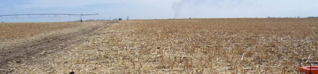
10


11 GIS used to locate Geophysic sites/testholes Data formulates base of aquifer map
12


13
14 Top of Brule or Pierre (and in some cases Niobrara) High electrical conductivity Low hydraulic conductivity Need to see through thick stack of sand + Ogallala
15
16


17 Started diversions in 1895 Canal seepage recharge impacts water levels/stream flows Significant impact to water budget Department of Natural Resources & USGS used NHD shapefile to indicate locations of canals No Laterals indicated Canals meandered wrong
18
19 USGS requested more precise locations Historical & current laterals Wasteways (return flows) Exact Diversion i Points GPS/GIS handhelds used to correct and refine Field time spent with irrigation personnel locating exact locations Substrate identified Cement, lining, soil, etc.


20

21
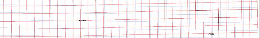
22

23
24
25


26


27 Pre Calibration Predictive Analy sis


28


29 Modflow Grids do not have correction lines Legal Sections do


30 As Model becomes more complex, grid size changes (shrinks, adjusts, etc.)


31 Challenge: Join layers Grid Size and Legal to get usable data per section Solution: Right-click layer, create join, join data based on spatial location Create Summary of data Average, sum, min, max, variance, standard dev. Outcome: Districts have sectional summary of modeling grid
32 LB 483 passed in 2009 Introduced by Senator Langemeier of Schuyler Allows controlled development of 10,000 ground water acres per NRD over 4 year period Designed as a response to initial designation then reversal of Lower Platte Basin being Fully Appropriated
33 LLNRD developed a criteria sheet for all new acre applications Points are assigned based on how an application fits within criteria Applications are redrawn using GIS based on landowner field boundaries on aerial photographs Shapefile for each application created LLNRD staff apply District approved ranking sheets to score applications Unbiased Few ties
34
35
36 Quantile Classification: An equal number of values are assigned in each class. All classes have the same number of features.
37
38 Point totals are assigned based on each criteria 2009: 12,951 applied acres 2,003 approved applications scored > : 11,958 applied acres 2,179 approved applications scored > Each approved site was visited i by NRD staff and shapefiles added to District acre certification
 Rights Transfers SDF Variances to Rules and Regulations SDF LB483 SDF Density of")
39 Current NRD Processes involving the model Irrigated Acre (1.3 Million) Rights Transfers SDF Variances to Rules and Regulations SDF LB483 SDF Density of development SSURGO 6,000 acres to approve 2011,2012
40
41 Internet Search: Elkhorn-Loup Model Phase 1&2 reports published Shapefiles: Base of Aquifer, Stream Depletion Factor Other related publications Contacts: Lower Loup Natural Resources District Tylr Naprstek, Coordinator (308) USGS N b k W S i C USGS Nebraska Water Science Center Jennifer S Stanton, Water modeler (402)


42
LIDAR: Statutory Compliance Benefits for Nebraska Natural Resources
 LIDAR: Statutory Compliance Benefits for Nebraska Natural Resources 2011 Nebraska GIS Symposium La Vista, NE April 21, 2011 Doug Hallum, P.G. Integrated Water Management Coordinator Nebraska Department
Hydrogeology and Simulated Effects of Future Water Use and Drought in the North Fork Red River Alluvial Aquifer: Progress Report
 Hydrogeology and Simulated Effects of Future Water Use and Drought in the North Fork Red River Alluvial Aquifer: Progress Report Developed in partnership with the Oklahoma Water Resources Board S. Jerrod
Programmatic Environmental Impact Statement Technical Appendix. Pallid Sturgeon
 Programmatic Environmental Impact Statement Technical Appendix Pallid Sturgeon Table of Contents Description of Habitat Area... 1 Historic Trends... 2 Current Conditions... 5 Methods of Analysis... 6 Results
C2VSim Fine Grid (C2VSim-FG) Version Development & Applications
 Version Development & Applications") C2VSim Fine Grid (C2VSim-FG) Version Development & Applications 2014 CWEMF Annual Meeting February 24, 2014 Presenters: Ali Taghavi & Mesut Cayar Collaborators: Reza Namvar (RMC), Jim Blanke (RMC), Tariq
C2VSim Fine Grid (C2VSim-FG) Version Development & Applications 2014 CWEMF Annual Meeting February 24, 2014 Presenters: Ali Taghavi & Mesut Cayar Collaborators: Reza Namvar (RMC), Jim Blanke (RMC), Tariq
Napa Valley Groundwater Sustainability: A Basin Analysis Report for the Napa Valley Subbasin
 Napa Valley Groundwater Sustainability: A Basin Analysis Report for the Napa Valley Subbasin A report prepared pursuant to California Water Code Section 10733.6(b)(3) EXECUTIVE SUMMARY (354.4(A)) 1 1.0
IDAWRA: Groundwater-flow model for the Wood River Valley aquifer system, south-central Idaho February 1, 2017, 11:30-1:00
 Idaho Section of the American Water Resources Association IDAWRA: Groundwater-flow model for the Wood River Valley aquifer system, south-central Idaho A three-dimensional numerical model of groundwater
Lecture 3. Data Sources for GIS in Water Resources
 Lecture 3 Data Sources for GIS in Water Resources GIS in Water Resources Spring 2015 http://www.data.gov/ 1 USGS GIS data for Water http://water.usgs.gov/maps.html Watersheds of the US 2-digit water resource
DRAFT. REVISED Draft. Paso Robles Subbasin Groundwater Sustainability Plan Chapter 6
 REVISED Draft Paso Robles Subbasin Groundwater Sustainability Plan Chapter 6 Prepared for the Paso Robles Subbasin Cooperative Committee and the Groundwater Sustainability Agencies February 14, 2019 Paso
Simulation of hydrologic and water quality processes in watershed systems using linked SWAT-MODFLOW-RT3D model
 Simulation of hydrologic and water quality processes in watershed systems using linked model Ryan Bailey, Assistant Professor Xiaolu Wei, PhD student Rosemary Records, PhD student Mazdak Arabi, Associate
MEMORANDUM. Jerry Conrow, Ojai Basin Groundwater Management Agency
 MEMORANDUM TO: FROM: Jerry Conrow, Ojai Basin Groundwater Management Agency Gregory Schnaar, PhD, Stephen J. Cullen, PhD, PG, DATE: August 6, 2014, 2014 SUBJECT: Ojai Basin Groundwater Model - Extended
Executive Summary. Water Quantity
 Executive Summary Stakeholders in the Rock-Glade Watershed have taken the initiative to proceed with watershed planning as provided by the State of Washington under the Watershed Management Act (Chapter
Napa Valley Groundwater Sustainability: A Basin Analysis Report for the Napa Valley Subbasin
 Napa Valley Groundwater Sustainability: A Basin Analysis Report for the Napa Valley Subbasin December 13, 2016 Napa County Board of Supervisors By Vicki Kretsinger Grabert and Reid Bryson Basin Analysis
DST MODEL SUPPORT SPATIAL DATA AND WATER RIGHTS INFORMATION. Tim Minor, Desert Research Institute
 DST MODEL SUPPORT SPATIAL DATA AND WATER RIGHTS INFORMATION Tim Minor, Desert Research Institute THIS PAGE INTENTIONALLY LEFT BLANK ii TABLE OF CONTENTS LIST OF FIGURES... iii INTRODUCTION... 1 PHASE III
Upper Truckee River Restoration Lake Tahoe, California Presented by Brendan Belby Sacramento, California
 Upper Truckee River Restoration Lake Tahoe, California Presented by Brendan Belby Sacramento, California Mike Rudd (Project Manager), Charley Miller & Chad Krofta Declines in Tahoe s Water Clarity The
Lower Tuolumne River Accretion (La Grange to Modesto) Estimated daily flows ( ) for the Operations Model Don Pedro Project Relicensing
 Estimated daily flows ( ) for the Operations Model Don Pedro Project Relicensing") Lower Tuolumne River Accretion (La Grange to Modesto) Estimated daily flows (1970-2010) for the Operations Model Don Pedro Project Relicensing 1.0 Objective Using available data, develop a daily time series
Lower Tuolumne River Accretion (La Grange to Modesto) Estimated daily flows (1970-2010) for the Operations Model Don Pedro Project Relicensing 1.0 Objective Using available data, develop a daily time series
USGS National Hydrography Dataset (NHD) and NHDPlus
 and NHDPlus") + 1 + USGS National Hydrography Dataset (NHD) and NHDPlus Al Rea USGS National Geospatial Program Western States Water Council August 1, 2018 + 2 USGS National Hydrography Datasets Hydrologic networks,
+ 1 + USGS National Hydrography Dataset (NHD) and NHDPlus Al Rea USGS National Geospatial Program Western States Water Council August 1, 2018 + 2 USGS National Hydrography Datasets Hydrologic networks,
Simplified GIS Requirements: New Data Models and Standards for Future WWDC Projects November 15 th, 2017 Technical Training
 Simplified GIS Requirements: New Data Models and Standards for Future WWDC Projects November 15 th, 2017 Technical Training Agenda Project Introduction Data Model and Metadata Framework Plan and Technical
Technical Memorandum. 1 Study Area. Interbasin Groundwater Flow Evaluation
 Technical Memorandum Interbasin Groundwater Flow Evaluation Subject: Prepared For: Butte County Department of Water and Resource Conservation Prepared by: Sara Miller and Craig Altare, P.G. Reviewed by:
WATERSHED SCALE CHARACTERIZATION OF GLACIAL AND BEDROCK AQUIFERS IN EASTERN NEBRASKA
 WATERSHED SCALE CHARACTERIZATION OF GLACIAL AND BEDROCK AQUIFERS IN EASTERN NEBRASKA Lawrence, KS May 21, 2015 Jared D. Abraham, MSc., Senior Research Geophysicist, XRI James C. Cannia, P.G., Senior Geologist,
REDWOOD VALLEY SUBAREA
 Independent Science Review Panel Conceptual Model of Watershed Hydrology, Surface Water and Groundwater Interactions and Stream Ecology for the Russian River Watershed Appendices A-1 APPENDIX A A-2 REDWOOD
Arkansas-Red Basin River Forecast Center Operations. RRVA Conference Durant, OK 8/22/2013 Jeff McMurphy Sr. Hydrologist - ABRFC
 Arkansas-Red Basin River Forecast Center Operations RRVA Conference Durant, OK 8/22/2013 Jeff McMurphy Sr. Hydrologist - ABRFC NWS River Forecast Centers NWS Weather Forecast Offices Operations Staffing
Teresa Santerre Hobby Manager
 Teresa Santerre Hobby Manager Sarita Hedgepeth Assistant Manager Charles Hill GIS Analyst Scott Lindsay Webmaster Work Completed BGS began by collecting historic well data in the Texas Hill Country from
Application of HydroGeoSphere in Impact Analysis of Land Subsidence due to Increased Groundwater Withdrawal along the Delta-Mendota Canal
 Application of HydroGeoSphere in Impact Analysis of Land Subsidence due to Increased Groundwater Withdrawal along the Delta-Mendota Canal Kirk Nelson Nigel Quinn Lisa Rainger George Matanga 03/01/11 1
Hydrogeologic Conceptual Models for Regional Flow Systems
 Hydrogeologic Conceptual Models for Regional Flow Systems R.T. Hanson, U.S. Geological Survey One Water Hydrologic Flow Model USGS MODFLOW-OWHM Session 4 Groundwater Subbasin Baseline Historic and Current
Minimum Standards for Aquatic Resource Delineations
 Minimum Standards for Aquatic Resource Delineations Matt Wilson Senior Project Manager, Nevada-Utah Section Sacramento District Regulatory Program Workshop 31 May 2018 US Army Corps of Engineers Delineation
Influence of Paleochannels on Seepage
 Study 4 Influence of Paleochannels on Seepage Public Draft 2014 Monitoring and Analysis Plan September 2013 August 2012 Influence of Paleochannels on Seepage 1. Statement of Need Historical maps, aerial
Platte River Flow and Sediment Transport Between North Platte and Grand Island, Nebraska ( )
") Platte River Flow and Sediment Transport Between North Platte and Grand Island, Nebraska (1895-1999) U.S. Department of the Interior Bureau of Reclamation TECHNICAL SERVICE CENTER Denver, Colorado October
Platte River Flow and Sediment Transport Between North Platte and Grand Island, Nebraska (1895-1999) U.S. Department of the Interior Bureau of Reclamation TECHNICAL SERVICE CENTER Denver, Colorado October
BSYSE 456/556 Surface Hydrologic Processes and Modeling
 BSYSE 456/556 Surface Hydrologic Processes and Modeling Lab 9 (Prepared by Erin Brooks and Jan Boll, UI, and Joan Wu, WSU) P Introduction One of the most difficult tasks in watershed assessment and management
Rainfall Estimation at S-44 Site
 Technical Note EMA # 389 Rainfall Estimation at S-44 Site (January 2 "d, 3 rd, and 1 7 th, 1999 Events) March 1999 by Alaa Ali & Wossenu Abtew Hydro Information Systems and Assessment Department Environmental
Minimum Standards for Wetland Delineations
 Minimum Standards for Wetland Delineations Jason Gipson Chief, Utah/Nevada Regulatory Branch Sacramento District Regulatory Program Workshop 16 Mar 2016 US Army Corps of Engineers Delineation Report Minimum
Hydrologic Modelling of the Upper Malaprabha Catchment using ArcView SWAT
 Hydrologic Modelling of the Upper Malaprabha Catchment using ArcView SWAT Technical briefs are short summaries of the models used in the project aimed at nontechnical readers. The aim of the PES India
Groundwater. (x 1000 km 3 /y) Reservoirs. Oceans Cover >70% of Surface. Groundwater and the. Hydrologic Cycle
 Reservoirs. Oceans Cover >70% of Surface. Groundwater and the. Hydrologic Cycle") Chapter 13 Oceans Cover >70% of Surface Groundwater and the Hydrologic Cycle Oceans are only 0.025% of Mass Groundwater Groundwater is liquid water that lies in the subsurface in fractures in rocks and
Chapter 13 Oceans Cover >70% of Surface Groundwater and the Hydrologic Cycle Oceans are only 0.025% of Mass Groundwater Groundwater is liquid water that lies in the subsurface in fractures in rocks and
TECHNICAL MEMORANDUM: MADERA SUBBASIN. Sustainable Groundwater Management Act (SGMA) DRAFT PRELIMINARY BASIN BOUNDARY WATER BUDGET.
 DRAFT PRELIMINARY BASIN BOUNDARY WATER BUDGET.") TECHNICAL MEMORANDUM: MADERA SUBBASIN Sustainable Groundwater Management Act (SGMA) DRAFT PRELIMINARY BASIN BOUNDARY WATER BUDGET Prepared by February 2018 DRAFT PRELIMINARY Technical Memorandum: Madera
TECHNICAL MEMORANDUM: MADERA SUBBASIN Sustainable Groundwater Management Act (SGMA) DRAFT PRELIMINARY BASIN BOUNDARY WATER BUDGET Prepared by February 2018 DRAFT PRELIMINARY Technical Memorandum: Madera
The Recent Long Island Drought
 The Recent Long Island Drought David J. Tonjes Department of Technology and Society Stony Brook University david.tonjes@stonybrook.edu Abstract Drought is a qualitatively defined and determined phenomenon.
Water Resources Challenges in Adams County, Pennsylvania
 Water Resources Challenges in Adams County, Pennsylvania Water Availability in the Upper Monocacy River Basin (Marsh, Rock, Alloway, and Toms Creeks) May 13, 2010 Cherie Schultz, Ph.D. Interstate Commission
GAM Run by Ali H. Chowdhury Ph.D., P.G. Texas Water Development Board Groundwater Resources Division (512)
") GAM Run 7-18 by Ali H. Chowdhury Ph.D., P.G. Texas Water Development Board Groundwater Resources Division (512) 936-0834 July 13, 2007 EXECUTIVE SUMMARY The groundwater availability model for the Hill
GAM Run 7-18 by Ali H. Chowdhury Ph.D., P.G. Texas Water Development Board Groundwater Resources Division (512) 936-0834 July 13, 2007 EXECUTIVE SUMMARY The groundwater availability model for the Hill
Technical Memorandum No Sediment Model
 Pajaro River Watershed Study in association with Technical Memorandum No. 1.2.9 Sediment Model Task: Development of Sediment Model To: PRWFPA Staff Working Group Prepared by: Gregory Morris and Elsie Parrilla
A Near Real-time Flood Prediction using Hourly NEXRAD Rainfall for the State of Texas Bakkiyalakshmi Palanisamy
 A Near Real-time Flood Prediction using Hourly NEXRAD for the State of Texas Bakkiyalakshmi Palanisamy Introduction Radar derived precipitation data is becoming the driving force for hydrological modeling.
Hydrogeology of East-Central Union County, Northeastern New Mexico
 Hydrogeology of East-Central Union County, Northeastern New Mexico Geoffrey Rawling April 2013 New Mexico Bureau of Geology & Mineral Resources 1 What are the important hydrogeologic issues in Union County?
IDENTIFYING GROUNDWATER/STREAM INTERACTION IN THE LOWER FLINT RIVER BASIN USING MULTIPLE STREAM PARAMETERS AND REMOTE SENSING DATA SETS
 IDENTIFYING GROUNDWATER/STREAM INTERACTION IN THE LOWER FLINT RIVER BASIN USING MULTIPLE STREAM PARAMETERS AND REMOTE SENSING DATA SETS Kathleen Rugel 1,2, Stephen W. Golladay 2, C. Rhett Jackson 3 AUTHORS:
USING GIS TO MODEL AND ANALYZE HISTORICAL FLOODING OF THE GUADALUPE RIVER NEAR NEW BRAUNFELS, TEXAS
 USING GIS TO MODEL AND ANALYZE HISTORICAL FLOODING OF THE GUADALUPE RIVER NEAR NEW BRAUNFELS, TEXAS ASHLEY EVANS While the state of Texas is well-known for flooding, the Guadalupe River Basin is one of
Groundwater-Surface Water Interactions along the Hangman, California, and Rock Creeks, September 30, 2009
 Groundwater-Surface Water Interactions along the Hangman, California, and Rock Creeks, September 30, 2009 Abstract This data collection effort was required to complete recommendations in the Hangman Creek
Rick Faber CE 513 Building a Base Map Lab #2 6/2/06
 Rick Faber CE 513 Building a Base Map Lab #2 6/2/06 1. Objective & Discussion: By using data for the Guadalupe river basin in Texas, we will get a chance to build a base map of hydrologic features. These
Section 4: Model Development and Application
 Section 4: Model Development and Application The hydrologic model for the Wissahickon Act 167 study was built using GIS layers of land use, hydrologic soil groups, terrain and orthophotography. Within
Nebraska Statewide Groundwater-Level Monitoring Report
 Nebraska Statewide Groundwater-Level Monitoring Report 2015 Aaron R. Young Mark E. Burbach Leslie M. Howard Conservation and Survey Division School of Natural Resources Nebraska Water Survey Paper Number
StreamStats: Delivering Streamflow Information to the Public. By Kernell Ries
 StreamStats: Delivering Streamflow Information to the Public By Kernell Ries U.S. Department of the Interior U.S. Geological Survey MD-DE-DC District 410-238-4317 kries@usgs.gov StreamStats Web Application
Selection and Ranking of Canals in the Gulf Coast Irrigation Division by Expected Seepage and/or Other Types of Losses APPENDIXES
 Selection and Ranking of Canals in the Gulf Coast Irrigation Division by Expected Seepage and/or Other Types of Losses APPENDIXES Final Report Submitted to the Lower Colorado River Authority September
Regional Drought Decision Support System (RDDSS) Project Update and Product Concepts
 Project Update and Product Concepts") Regional Drought Decision Support System (RDDSS) Project Update and Product Concepts Part of the Red River Basin Decision Information Network (RRBDIN) NEXT-GEN RRBDIN Decision Support for the Red River
Regional Drought Decision Support System (RDDSS) Project Update and Product Concepts Part of the Red River Basin Decision Information Network (RRBDIN) NEXT-GEN RRBDIN Decision Support for the Red River
Figure 1 Double-mass plots of precipitation at White Bear Lake from three gridded data sets (Daymet, HIDEN, and PRISM) versus the Minnesota Climate
 versus the Minnesota Climate") Figure 1 Double-mass plots of precipitation at White Bear Lake from three gridded data sets (Daymet, HIDEN, and PRISM) versus the Minnesota Climate Division 6 average. Straight lines through the plots
Figure 1 Double-mass plots of precipitation at White Bear Lake from three gridded data sets (Daymet, HIDEN, and PRISM) versus the Minnesota Climate Division 6 average. Straight lines through the plots
MISSOURI RIVER BASIN WATER MANAGEMENT SPRING 2019 PUBLIC MEETINGS
 MISSOURI RIVER BASIN WATER MANAGEMENT SPRING 2019 PUBLIC MEETINGS April 9 11:00 a.m. Fort Peck, MT April 9 6:00 p.m. Bismarck, ND April 10 10:00 a.m. Pierre, SD April 10 4:00 p.m. Sioux City, IA April
AGRICULTURAL WATER RESOURCES DECISION SUPPORT SYSTEM AND EVAPOTRANSPIRATION TOOLBOX. L. Albert Brower, Curtis L. Hartzell, and Steffen P.
 AGRICULTURAL WATER RESOURCES DECISION SUPPORT SYSTEM AND EVAPOTRANSPIRATION TOOLBOX L. Albert Brower, Curtis L. Hartzell, and Steffen P. Meyer 1 ABSTRACT: There is a critical need for improvement in calculating
APPROVED JURISDICTIONAL DETERMINATION FORM U.S. Army Corps of Engineers
 APPROVED JURISDICTIONAL DETERMINATION FORM U.S. Army Corps of Engineers This form should be completed by following the instructions provided in Section IV of the JD Form Instructional Guidebook. SECTION
Restoration Goals TFG Meeting. Agenda
 San Joaquin River Restoration Program Restoration Goals TFG Meeting Reach 2B Update April 28, 2010 Agenda 1. Introductions 2. Program Restoration Goal Context 3. Program Update a) Interim Flows b) EIS/EIR
CREDENTIALS. HERBERT E. JOHNSTON 185 Manville Hill Rd, Unit 203 Cumberland, Rhode Island (401)
") CREDENTIALS HERBERT E. JOHNSTON 185 Manville Hill Rd, Unit 203 Cumberland, Rhode Island 02864-3617 (401) 658 4747 e-mail: hjohns1931@aol.com OCCUPATION: Hydrogeologist POSITIONS: o Groundwater consultant
CREDENTIALS HERBERT E. JOHNSTON 185 Manville Hill Rd, Unit 203 Cumberland, Rhode Island 02864-3617 (401) 658 4747 e-mail: hjohns1931@aol.com OCCUPATION: Hydrogeologist POSITIONS: o Groundwater consultant
Valenciano Reservoir Safe Yield Study. Prepared by: CSA Architects & Engineers, LLP
 Valenciano Reservoir Safe Yield Study Prepared by: CSA Architects & Engineers, LLP CSA Group Prepared for: Puerto Rico Aqueduct and Sewer Authority Planning TABLE OF CONTENTS 1 Introduction...1 1.1 Safe
APPROVED JURISDICTIONAL DETERMINATION FORM U.S. Army Corps of Engineers
 APPROVED JURISDICTIONAL DETERMINATION FORM U.S. Army Corps of Engineers This form should be completed by following the instructions provided in Section IV of the JD Form Instructional Guidebook. SECTION
v Prerequisite Tutorials GSSHA WMS Basics Watershed Delineation using DEMs and 2D Grid Generation Time minutes
 v. 10.1 WMS 10.1 Tutorial GSSHA WMS Basics Creating Feature Objects and Mapping Attributes to the 2D Grid Populate hydrologic parameters in a GSSHA model using land use and soil data Objectives This tutorial
Use of PRISM Data. for Precipitation Estimates. in ESPAM2 AS BUILT
 Use of PRISM Data for Precipitation Estimates in ESPAM2 AS BUILT Prepared by Idaho Water Resources Research Institute In fulfillment of the Water-Budget Component Precipitation of Contract # CON00803 for
Name of Applicant Mailing Address address Telephone Number
 District Court, Water Division, Colorado Court Address: CONCERNING THE APPLICATION FOR WATER RIGHTS OF Applicant: In the River or its Tributaries In COUNTY Attorney or Party Without Attorney (Name and
COUPLED SURFACE WATER-GROUNDWATER MODEL TO ANALYZE SUSTAINABILITY OF THE ATASCADERO SUBBASIN. A Thesis presented to
 COUPLED SURFACE WATER-GROUNDWATER MODEL TO ANALYZE SUSTAINABILITY OF THE ATASCADERO SUBBASIN A Thesis presented to the Faculty of California Polytechnic State University, San Luis Obispo In Partial Fulfillment
Leveraging new models and data to improve flood stage forecast. Improving Flood Stage Forecasting in the Feather River Watershed. September 11 th 2015
 Leveraging new models and data to improve flood stage forecast Improving Flood Stage Forecasting in the Feather River Watershed September 11 th 2015 Mitch Russo, P.E. (DWR) Ashok Bathulla, P.E., CFM (GEI)
Roger Andy Gaines, Research Civil Engineer, PhD, P.E.
 Roger Andy Gaines, Research Civil Engineer, PhD, P.E. Research Civil Engineer/Regional Technical Specialist Memphis District August 24, 2010 Objectives Where we have been (recap of situation and what s
APPROVED JURISDICTIONAL DETERMINATION FORM U.S. Army Corps of Engineers
 APPROVED JURISDICTIONAL DETERMINATION FORM U.S. Army Corps of Engineers This form should be completed by following the instructions provided in Section IV of the JD Form Instructional Guidebook. SECTION
Regional Groundwater Availability Study of the Edwards-Trinity Aquifer in parts of Pecos, Brewster, Jeff Davis and Reeves Counties, Texas
 Regional Groundwater Availability Study of the Edwards-Trinity Aquifer in parts of Pecos, Brewster, Jeff Davis and Reeves Counties, Texas Johnathan R. Bumgarner, P.G. Task Leads: Greg Stanton (Project
Evaluating Physical, Chemical, and Biological Impacts from the Savannah Harbor Expansion Project Cooperative Agreement Number W912HZ
 Evaluating Physical, Chemical, and Biological Impacts from the Savannah Harbor Expansion Project Cooperative Agreement Number W912HZ-13-2-0013 Annual Report FY 2018 Submitted by Sergio Bernardes and Marguerite
Development of Improved Stream Mapping for NC
 Development of Improved Stream Mapping for NC Presentation for Soil Science Society of North Carolina NC Division of Water Quality January 21, 2009 What are stream maps used for? Riparian buffer rules
APPROVED JURISDICTIONAL DETERMINATION FORM U.S. Army Corps of Engineers
 APPROVED JURISDICTIONAL DETERMINATION FORM U.S. Army Corps of Engineers This form should be completed by following the instructions provided in Section IV of the JD Form Instructional Guidebook. SECTION
Big Wood River. General Information
 General Information The flows out of the southern portion of the Sawtooth National Recreation Area in central Idaho. The study reach is about a,200 ft length of river about.5 miles upstream from the discontinued
Napa County Comprehensive Groundwater Monitoring Program 2015 Annual Report and CASGEM Update
 Napa County Comprehensive Groundwater Monitoring Program 2015 Annual Report and CASGEM Update April 21, 2016 Watershed Information & Conservation Council By Vicki Kretsinger Grabert Overview Evolving groundwater
Weather Modification Activities in the Colorado River Basin. Mohammed Mahmoud
 Weather Modification Activities in the Colorado River Basin Mohammed Mahmoud Historical Information Authorized by 1968 Basin Project Act Substantially completed in 1993 Responsible for repaying reimbursable
The Favorability of Florida s Geology to Sinkhole Formation
 Florida Geological Survey The Favorability of Florida s Geology to Sinkhole Formation Clint Kromhout Alan Baker October 24, 2017 Subsidence Report Database Map of Subsidence Incident Reports taken from
APPROVED JURISDICTIONAL DETERMINATION FORM U.S. Army Corps of Engineers
 APPROVED JURISDICTIONAL DETERMINATION FORM U.S. Army Corps of Engineers This form should be completed by following the instructions provided in Section IV of the JD Form Instructional Guidebook. SECTION
APPLICATION FOR CONDITIONAL ABSOLUTE WATER STORAGE RIGHT
 District Court, Water Division, Colorado Court Address: CONCERNING THE APPLICATION FOR WATER RIGHTS OF Applicant: In the River or its Tributaries In COUNTY Attorney or Party Without Attorney (Name and
WATER RESOURCES AND URBANIZATION Vulnerability and Adaptation in the Context of Climate Variability
 WATER RESOURCES AND URBANIZATION Vulnerability and Adaptation in the Context of Climate Variability Krishna Balakrishnan LA 221: Class Project Problem Statement My PhD research focuses on the vulnerability
George Mason University Department of Civil, Environmental and Infrastructure Engineering. Dr. Celso Ferreira Prepared by Lora Baumgartner
 George Mason University Department of Civil, Environmental and Infrastructure Engineering Dr. Celso Ferreira Prepared by Lora Baumgartner Exercise Topic: Downloading Spatial Data Objectives: a) Become
APPROVED JURISDICTIONAL DETERMINATION FORM U.S. Army Corps of Engineers
 APPROVED JURISDICTIONAL DETERMINATION FORM U.S. Army Corps of Engineers This form should be completed by following the instructions provided in Section IV of the JD Form Instructional Guidebook. SECTION
INDIAN INSTITUTE OF SCIENCE STOCHASTIC HYDROLOGY. Course Instructor : Prof. P. P. MUJUMDAR Department of Civil Engg., IISc.
 INDIAN INSTITUTE OF SCIENCE STOCHASTIC HYDROLOGY Course Instructor : Prof. P. P. MUJUMDAR Department of Civil Engg., IISc. Course Contents Introduction to Random Variables (RVs) Probability Distributions
The Stochastic Event Flood Model Applied to Minidoka Dam on the Snake River, Idaho
 The Stochastic Event Flood Model Applied to Minidoka Dam on the Snake River, Idaho K. L. Bullard 1, M. G. Schaeffer 2, B. A. Barker 3, D. Sutley 4, and V. Leverson 5 1 Bureau of Reclamation, Flood Hydrology
USGS Hydrography Overview. May 9, 2018
 + 1 USGS Hydrography Overview May 9, 2018 + 2 The National Geospatial Program Provides the geospatial baseline of the Nation s topography, natural landscape and built environment through The National Map,
Building a European-wide hydrological model
 Building a European-wide hydrological model 2010 International SWAT Conference, Seoul - South Korea Christine Kuendig Eawag: Swiss Federal Institute of Aquatic Science and Technology Contribution to GENESIS
Soils, Hydrogeology, and Aquifer Properties. Philip B. Bedient 2006 Rice University
 Soils, Hydrogeology, and Aquifer Properties Philip B. Bedient 2006 Rice University Charbeneau, 2000. Basin Hydrologic Cycle Global Water Supply Distribution 3% of earth s water is fresh - 97% oceans 1%
MVP WMS, George Schorr
 APPROVED JURISDICTIONAL DETERMINATION FORM U.S. Army Corps of Engineers This form should be completed by following the instructions provided in Section IV of the JD Form Instructional Guidebook. SECTION
Management of Natural and Environmental Resources for Sustainable Agricultural Development
 World Meteorological Organization (WMO) Management of Natural and Environmental Resources for Sustainable Agricultural Development Use of the Object Modeling System for Operational Water Supply Forecasting
Vermont Stream Geomorphic Assessment. Appendix J. Vermont Regional Hydraulic Geometry Curves
 Vermont Stream Geomorphic Assessment Appendix J Vermont Regional Hydraulic Geometry Curves River Management Program Vermont Water Quality Division November, 2001 Natural Resources - J0 - VT Agency of Background
Water Management and Hydrology of Northeast Shark River Slough from 1940 to 2015
 Water Management and Hydrology of Northeast Shark River Slough from 1940 to 2015 Greater Everglades Ecosystem Restoration Conference April 2015 Kevin Kotun, Hydrologist Physical Resources Branch South
Base Level Engineering FEMA Region 6
 Base Level Engineering Over the past five years, has been evaluating its investment approach and data preparation work flow to establish an efficient and effective change in operation, generating an approach
Simulating the groundwater discharge to wetlands. Mukwonago Basin Example and Potential Application in Dane County
 Simulating the groundwater discharge to wetlands Mukwonago Basin Example and Potential Application in Dane County Conceptual Model Topography is major control on flow to wetlands Land Surface Water Table
Natural Variability in Annual Maximum Water Level and Outflow of Yellowstone Lake
 Natural Variability in Annual Maximum Water Level and Outflow of Yellowstone Lake Phillip E. Farnes Abstract The water level in Yellowstone Lake varies each year in response to differences in the winter
APPROVED JURISDICTIONAL DETERMINATION FORM U.S. Army Corps of Engineers
 APPROVED JURISDICTIONAL DETERMINATION FORM U.S. Army Corps of Engineers This form should be completed by following the instructions provided in Section IV of the JD Form Instructional Guidebook. SECTION
Combining sensor and forecast information to aid decision making: real-time determination of hydrological peat fire risk in Kalimantan
 Combining sensor and forecast information to aid decision making: real-time determination of hydrological peat fire risk in Kalimantan Jaap Schellekens Based on work by: Aljosja Hooijer, Ronald Vernimmen,
Recent Analysis and Improvements of the Statistical Water Supply Forecasts for the Upper Klamath Lake Basin, Oregon and California, USA
 Recent Analysis and Improvements of the Statistical Water Supply Forecasts for the Upper Klamath Lake Basin, Oregon and California, USA Jolyne Lea and David Garen, USDA/NRCS, Adam Kennedy, Portland State
Data Collection and GIS Applications
 Data Collection and GIS Applications Governor s s Conference on the Management of the Illinois River System Jeff Jack of all Trades Boeckler, IDNR Introduction Collecting available GIS data sets Creating
Influence of spatial variation in precipitation on artificial neural network rainfall-runoff model
 Hydrology Days 212 Influence of spatial variation in precipitation on artificial neural network rainfall-runoff model André Dozier 1 Department of Civil and Environmental Engineering, Colorado State University
Development and Land Use Change in the Central Potomac River Watershed. Rebecca Posa. GIS for Water Resources, Fall 2014 University of Texas
 Development and Land Use Change in the Central Potomac River Watershed Rebecca Posa GIS for Water Resources, Fall 2014 University of Texas December 5, 2014 Table of Contents I. Introduction and Motivation..4
An Adaptive Assessment of the Flushing Flow Needs of the Lower Poudre River, Colorado: First Evaluation
 Hydrology Days 29 An Adaptive Assessment of the Flushing Flow Needs of the Lower Poudre River, Colorado: First Evaluation 1 Robert T Milhous Hydrologist. Fort Collins, Colorado 8526 Abstract. Adaptive
Lake Tahoe. Response to Winter Rain Events. Dr. David Maidment University of Texas at Austin. Dr. David Tarboton Utah State University
 CE 394K GIS in Water Resources Fall 2017 University of Texas at Austin PREPARED FOR Dr. David Maidment University of Texas at Austin Dr. David Tarboton Utah State University PREPARED BY Joel Lagade Jr.,
Implementing a Project with 319 Funds: The Spring Brook Meander Project. Leslie A. Berns
 Implementing a Project with 319 Funds: The Spring Brook Meander Project Leslie A. Berns "...to acquire... and hold lands... for the purpose of protecting and preserving the flora, fauna and scenic beauties...
Today I will describe the groundwater/surface water interaction in the CRB in Mosier basin.
 Today I will describe the groundwater/surface water interaction in the CRB in Mosier basin. 1 Ken Lite, studying groundwater resource in Mosier basin since 1980 s (photo by A. Bouchier) 2012 with Jonathan
2 Groundwater Basin Monitoring
 Zone 7 Water Agency 2 Groundwater Basin Monitoring Programs 2.1 Climatological Monitoring 2 Groundwater Basin Monitoring Programs This section describes Zone 7's Climatological Monitoring Program which
Designing a Dam for Blockhouse Ranch. Haley Born
 Designing a Dam for Blockhouse Ranch Haley Born CE 394K GIS in Water Resources Term Paper Fall 2011 Table of Contents Introduction... 1 Data Sources... 2 Precipitation Data... 2 Elevation Data... 3 Geographic