Regional Groundwater Availability Study of the Edwards-Trinity Aquifer in parts of Pecos, Brewster, Jeff Davis and Reeves Counties, Texas
|
|
|
- Lester Lucas
- 5 years ago
- Views:
Transcription
1 Regional Groundwater Availability Study of the Edwards-Trinity Aquifer in parts of Pecos, Brewster, Jeff Davis and Reeves Counties, Texas Johnathan R. Bumgarner, P.G. Task Leads: Greg Stanton (Project Chief), John Bumgarner, Daniel Pearson, Cary Carman, Jon Thomas, Andy Teeple, Natalie Houston, Brian Clark In cooperation with the Middle Pecos Groundwater Conservation District, Pecos County, City of Fort Stockton, Brewster County, and Pecos County Water Control and Improvement District No. 1 March 2012

2 Outline Background Project Overview Study Area Phase I Data Compilation Data Collection Data Management Phase II: Conceptual Model Phase III: Numerical Model
3 Background Study area includes parts of Pecos, Brewster, Jeff Davis, and Reeves Counties Edwards-Trinity is the principal aquifer Resource managers are concerned with future groundwater availability and the potential effects of withdrawal increases and/or redistribution Scale of the existing regional Groundwater Availability Model (GAM) is too coarse to adequately simulate the Edwards-Trinity aquifer in the study area
4 Project Overview Evaluate potential changes in groundwater withdrawals and distribution Evaluation is dependent upon the compilation and interpretation of existing data and new data collection Conceptual and numerical groundwater models will be developed Numerical model will be used to simulate the effects of possible pumping changes on the groundwater system

5 Study Area: Location Fort Stockton Study Area Approx. 2.5M Acres

6 Study Area: Major Aquifers Pecos Alluvium Fort Stockton Edwards-Trinity

7 Study Area: Minor Aquifers Rustler Dockum Fort Stockton Igneous Capitan Reef
8 Phase I: Data Compilation Locate and compile existing scientific literature, analyses, and datasets More than 8,600 data points acquired from 10 sources: USGS, MPGCD, BCGCD, TWDB, TRRC, TCEQ, BEG, and Private firms Acquired information examples: Basemap information Well and spring locations Geophysical and lithologic well logs Aquifer properties Water quality Groundwater levels Data gap analysis
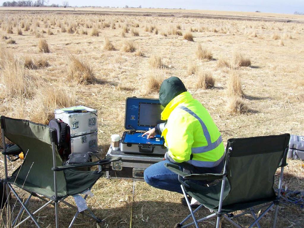
9 Phase I: Data Collection Borehole geophysics Collected at 44 wells to supplement existing data Resistivity, caliper, gamma, fluid resistivity, temperature, flowmeter, borehole imager Surface geophysics Time-Domain Electromagnetics (TDEM) collected at four sites Audiomagnetotelluric (AMT) Soundings collected at 13 sites Geochemical sampling 44 sites: 38 wells, 4 springs, and 2 Pecos River samples All 44 sites: Major ions, nutrients, trace elements, and isotopes Select sites: Pesticides and environmental tracers Water levels

10 Phase I: Geophysics Data Locations H i d e t h i s Historical data location Geophysics data collection locations Geochemical sampling sites
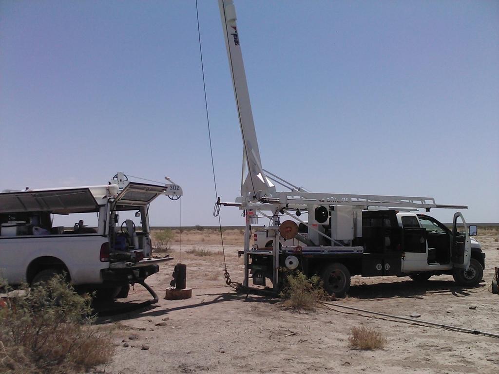
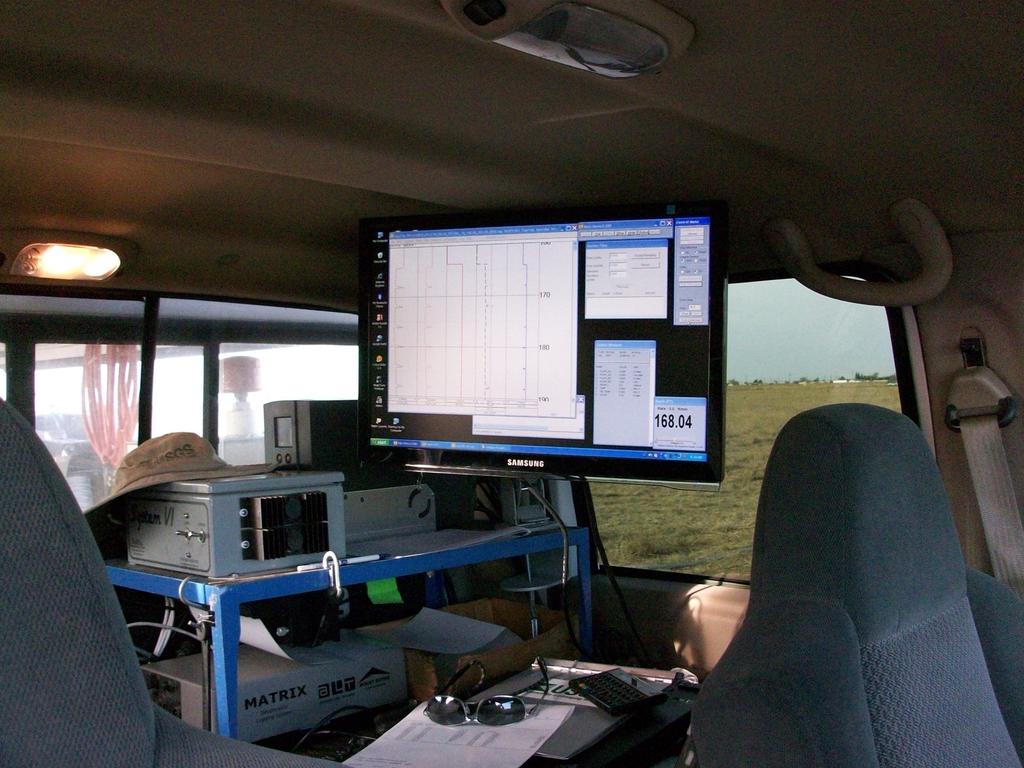
11 Phase I: Geophysics Data Collection
12 Phase I: Geochemical Data Locations Historical data location Geochemical data collection locations

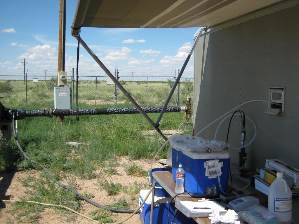
13 Phase I: Geochemical Data Collection
14 Phase I: Data Management Geodatabase development Central data repository Features and tables Query and relate data Stratigraphy Geology Sites Aquifers Geodatabase Results Samples Logs Parameters

15 Phase I: Data Series Report USGS Data Series Report 678 Released 3/20/2012 Describes Data sources Data collection methods Geodatabase development
16 Phase II: Conceptual Model Data synthesis and interpretation Hydrogeologic framework Hydrostratigraphy Structure Aquifer properties Geochemistry Groundwater-flow system Regional trends Recharge Groundwater mixing and discharge USGS Scientific Investigations Report planned for 2012
17 Phase II: Hydrogeologic framework Hydrostratigraphy Geophysical and lithologic logs Determine tops and bases of hydrostratigraphic units Structure Interpolate picks to create surfaces Unit thicknesses Fault zones Aquifer properties Historical pump-test data Aquifer transmissivities


18 Phase II: Hydrogeologic framework Land Surface Base of Edwards-Trinity Top of Edwards-Trinity
19 Phase II: Geochemistry Groundwater quality Distinct chemical characteristics of water from different sources and different aquifers Flow paths Potential recharge sources Mixing pathways Recharge Source Recharge Source Mixing Chemical Reactions Water-Rock Interaction Aquifer Interaction Sample

20 Phase II: Groundwater-Flow System Groundwater-level and geochemical interpretations used in context with the hydrogeologic framework Top of Edwards-Trinity Base of Edwards-Trinity

21 Phase III: Numerical Model Quantitative data analysis and interpretation MODFLOW 3D finite-difference groundwater flow model Model development Sensitivity and uncertainty analyses Calibration Simulations

22 Summary Phase I Complete Data Compilation Data Collection Data Management Phase II: Conceptual Model In Progress Hydrogeologic framework Geochemistry Groundwater-flow system Phase III: Numerical Model In Progress Development Sensitivity and uncertainty Calibration Simulations

23 Contacts: USGS Texas Water Science Center Greg Stanton Groundwater Specialist John Bumgarner Hydrologist Questions?
Groundwater in Bedrock Aquifers: Development Considerations
 Slide 1 Groundwater in Bedrock Aquifers: Development Considerations Pelham, New Hampshire October 3, 2016 Building Trust. Engineering Success. Slide 2 OUTLINE Background on groundwater in bedrock aquifers
Finding Large Capacity Groundwater Supplies for Irrigation
 Finding Large Capacity Groundwater Supplies for Irrigation December 14, 2012 Presented by: Michael L. Chapman, Jr., PG Irrigation Well Site Evaluation Background Investigation Identify Hydrogeologic Conditions
Delineating and Assessing Saline Ground Water Resources
 Delineating and Assessing Saline Ground Water Resources USGS Water Science Centers Arkansas Georgia OklahomA Sulfur water at Chickasaw National Recreation Area Sulphur, Oklahoma Background and Problem
Understanding Water Level Transducers. Texas Groundwater Summit San Antonio, TX 2018
 Understanding Water Level Transducers Texas Groundwater Summit San Antonio, TX 2018 Presented by Raymond L Straub Jr., P.G. Raymond L Straub Jr., P.G. Licensed Professional Geoscientist President of Straub
Geological Survey of Alabama Groundwater Assessment Program
 Geological Survey of Alabama Groundwater Assessment Program Hydrogeologic Characterization and Groundwater Source Development Assessment for Area 2, Southwestern Alabama Gheorghe M. Ponta, Marlon R. Cook,
Challenges in Calibrating a Large Watershed Model with Varying Hydrogeologic Conditions
 Challenges in Calibrating a Large Watershed Model with Varying Hydrogeologic Conditions Presented by Johnathan R. Bumgarner, P.G., Celine A.L. Louwers, & Monica P. Suarez, P.E. In cooperation with the
GAM Run by Ali H. Chowdhury Ph.D., P.G. Texas Water Development Board Groundwater Resources Division (512)
") GAM Run 7-18 by Ali H. Chowdhury Ph.D., P.G. Texas Water Development Board Groundwater Resources Division (512) 936-0834 July 13, 2007 EXECUTIVE SUMMARY The groundwater availability model for the Hill
GAM Run 7-18 by Ali H. Chowdhury Ph.D., P.G. Texas Water Development Board Groundwater Resources Division (512) 936-0834 July 13, 2007 EXECUTIVE SUMMARY The groundwater availability model for the Hill
Pajaro Valley Hydrologic Model Base-Case Scenario
 Pajaro Valley Hydrologic Model Base-Case Scenario Board of Directors Meeting March 23, 2011 Presented by: Brian Lockwood, P.G., Hydrologist Acknowledgements, Base-Case The concept for the Base-Case scenario
IDAWRA: Groundwater-flow model for the Wood River Valley aquifer system, south-central Idaho February 1, 2017, 11:30-1:00
 Idaho Section of the American Water Resources Association IDAWRA: Groundwater-flow model for the Wood River Valley aquifer system, south-central Idaho A three-dimensional numerical model of groundwater
Evolution of the conceptual hydrogeologic and ground-water flow model for Las Vegas Valley, Clark County, Nevada
 Evolution of the conceptual hydrogeologic and ground-water flow model for Las Vegas Valley, Clark County, Nevada Geological Society of America Annual Meeting November 14, 2 David J. Donovan Southern Nevada
Hydrogeology and Simulated Effects of Future Water Use and Drought in the North Fork Red River Alluvial Aquifer: Progress Report
 Hydrogeology and Simulated Effects of Future Water Use and Drought in the North Fork Red River Alluvial Aquifer: Progress Report Developed in partnership with the Oklahoma Water Resources Board S. Jerrod
Case Study: University of Connecticut (UConn) Landfill
 Landfill") Case Study: University of Connecticut (UConn) Landfill Problem Statement:» Locate disposal trenches» Identify geologic features and distinguish them from leachate and locate preferential pathways in fractured
Case Study: University of Connecticut (UConn) Landfill Problem Statement:» Locate disposal trenches» Identify geologic features and distinguish them from leachate and locate preferential pathways in fractured
PRELIMINARY. Select Geophysical Methods and Groundwater Modeling: Examples from USGS studies. Claudia Faunt and a cast of others
 Select Geophysical Methods and Groundwater Modeling: Examples from USGS studies Claudia Faunt and a cast of others Current Preliminary Studies Stanford Water in the West Groundwater Data Workshop Series:
Harvey Thorleifson, Director, Minnesota Geological Survey. Status of geological mapping needed for groundwater protection in Minnesota
 Harvey Thorleifson, Director, Minnesota Geological Survey Status of geological mapping needed for groundwater protection in Minnesota Minnesota is located between the Dakotas and Wisconsin, north of Iowa,
B. T. Brady, M. S. Bedinger, John Mikels, William H. Langer, and Deborah A. Mulvihill
 DEPARTMENT OF THE INTERIOR UNITED STATES GEOLOGICAL SURVEY TO ACCOMPANY WRI REPORT 83-4121-B MAP SHOWING GROUND-WATER LEVELS, SPRINGS. AND DEPTH TO GROUND WATER, BASIN AND RANGE PROVINCE, TEXAS by B. T.
Airborne Geophysics to Map Groundwater. Bill Brown
 Airborne Geophysics to Map Groundwater Bill Brown bb@skytem.com A 6 borehole represents 1 millionth of an acre Aquifer Materials An aquifer is an underground layer of water bearing permeable rock, rock
Hydraulic and Water-Quality Characterization of Fractured-Rock Aquifers Using Borehole Geophysics
 Hydraulic and Water-Quality Characterization of Fractured-Rock Aquifers Using Borehole Geophysics John H. Williams Office of Ground Water Troy, New York Flow in Open Borehole Runkel and others (2003) Ambient
CE 394K.3 Term Project Report. 3-D Underground Representation of Barnett Shale, TX
 CE 394K.3 Term Project Report 3-D Underground Representation of Barnett Shale, TX Prepared by Weili Lin Instructed by: Dr. David Maidment Environmental and Water Resources Engineering University of Texas
Water Volume Calculation of Hill Country Trinity Aquifer Blanco, Hays, and Travis Counties, Central Texas
 Water Volume Calculation of Hill Country Trinity Aquifer Blanco, Hays, and Travis Counties, Central Texas GIS and GPS Applications in Earth Science Saya Ahmed December, 2010 1 Introduction: Trinity Aquifer
AIRBORNE ELECTROMAGNETIC SURVEYS FOR 3D GEOLOGICAL MAPPING
 AIRBORNE ELECTROMAGNETIC SURVEYS FOR 3D GEOLOGICAL MAPPING Jared D. Abraham 1 and James C. Cannia 2 1 United States Geological Survey, Crustal Geophysics and Geochemistry Science Center, United States
First Technical Report Geophysical experiments near Kajiado town
 First Technical Report Geophysical experiments near Kajiado town Synthesis Report of First case study within the ISGEAG VIA Water project By: Michel Groen *), Harry Rolf **), and Ammon Muiti ***) *) Acacia
Dept. of Earth and Environmental Sciences, University of Waterloo, 200 University Ave W, Waterloo, Ontario, Canada, N2L 3G1 2
 A modelling strategy to develop a regional Quaternary geological model across rural and urban areas and administrative borders using existing geological information M. Ross 1, M. Parent 2, A. Taylor 1
APPENDIX 3B OCCURRENCE OF SIGNIFICANT RIVER ALLUVIUM AQUIFERS IN THE PLATEAU REGION
 Plateau Region Water Plan January 2011 APPENDIX 3B OCCURRENCE OF SIGNIFICANT RIVER ALLUVIUM AQUIFERS IN THE PLATEAU REGION Occurrence of Significant River Alluvium Aquifers in the Plateau Region Prepared
CREDENTIALS. HERBERT E. JOHNSTON 185 Manville Hill Rd, Unit 203 Cumberland, Rhode Island (401)
") CREDENTIALS HERBERT E. JOHNSTON 185 Manville Hill Rd, Unit 203 Cumberland, Rhode Island 02864-3617 (401) 658 4747 e-mail: hjohns1931@aol.com OCCUPATION: Hydrogeologist POSITIONS: o Groundwater consultant
CREDENTIALS HERBERT E. JOHNSTON 185 Manville Hill Rd, Unit 203 Cumberland, Rhode Island 02864-3617 (401) 658 4747 e-mail: hjohns1931@aol.com OCCUPATION: Hydrogeologist POSITIONS: o Groundwater consultant
WATERSHED SCALE CHARACTERIZATION OF GLACIAL AND BEDROCK AQUIFERS IN EASTERN NEBRASKA
 WATERSHED SCALE CHARACTERIZATION OF GLACIAL AND BEDROCK AQUIFERS IN EASTERN NEBRASKA Lawrence, KS May 21, 2015 Jared D. Abraham, MSc., Senior Research Geophysicist, XRI James C. Cannia, P.G., Senior Geologist,
The Capitan Aquifer - Ellenburger Production Wells Geothermal Engine Source?
 GEOTHERMAL ENERGY UTILIZATION ASSOCIATED WITH OIL & GAS DEVELOPMENT June 17-18, 2008 Southern Methodist University Dallas, Texas The Capitan Aquifer - Ellenburger Production Wells Geothermal Engine Source?
Minnesota Ground Water Association
 Fall 2006 Conference November 14, 2006 Ground Water Management The Minnesota Model - Data, Tools, Techniques, and Organization Jim Berg, Minnesota DNR Waters Mapping Hydrologic Systems Recent hydrologic/geologic
Ground Water in the Piedmont and Blue Ridge
 engineering earth's development preserving earth's integrity Engineering Earth s Development Preserving Earth s Integrity Ground Water in the Piedmont and Blue Ridge Jim Renner Acknowledgements Contributors:
Interpretation and application of hydrogeological concepts to commercial scale brine extraction projects
 Interpretation and application of hydrogeological concepts to commercial scale brine extraction projects ABSTRACT Terry Braun, Pablo Cortegoso*, Cristian Pereira* and Vladimir Ugorets* 1. SRK Consulting
THE ROLE OF 3-D GEOLOGIC MODELING AND DATABASE SOLUTIONS IN THE VIRTTAANKANGAS ARTIFICIAL RECHARGE PROJECT, SOUTHWESTERN FINLAND
 THE ROLE OF 3-D GEOLOGIC MODELING AND DATABASE SOLUTIONS IN THE VIRTTAANKANGAS ARTIFICIAL RECHARGE PROJECT, SOUTHWESTERN FINLAND Artimo, A. 1, S. Saraperä 2, and I. Ylander 1 1 Turku Region Water Ltd.,
Arc Hydro Groundwater Data Model
 Arc Hydro Groundwater Data Model This is a modified and abridged version of a presentation given by Professor David Maidment at UTexas, Austin. It was part of GIS in Water Resources - Fall 2017. The original
KARST HYDROGEOLOGY SCOPING INVESTIGATION OF THE SAN SOLOMON SPRING AREA: CULBERSON, JEFF DAVIS, AND REEVES COUNTIES, TEXAS
 NCKRI REPORT OF INVESTIGATION 8 KARST HYDROGEOLOGY SCOPING INVESTIGATION OF THE SAN SOLOMON SPRING AREA: CULBERSON, JEFF DAVIS, AND REEVES COUNTIES, TEXAS National Cave and Karst Research Institute www.nckri.org
David de Courcy-Bower and Samuel Mohr
 Applicability and Limitations of LNAPL Transmissivity as a Metric within Bedrock Formations Insert then choose Picture select your picture. Right click your picture and Send to back. David de Courcy-Bower
An investigation of Irish thermal springs: provenance, pathways and potential Sarah Blake
 An investigation of Irish thermal springs: provenance, pathways and potential Sarah Blake IRETHERM Workshop, Dublin 1 st April 2016 Thermal springs in Ireland Thermal springs in Ireland Thermal springs
11/22/2010. Groundwater in Unconsolidated Deposits. Alluvial (fluvial) deposits. - consist of gravel, sand, silt and clay
 deposits. - consist of gravel, sand, silt and clay") Groundwater in Unconsolidated Deposits Alluvial (fluvial) deposits - consist of gravel, sand, silt and clay - laid down by physical processes in rivers and flood plains - major sources for water supplies
Groundwater in Unconsolidated Deposits Alluvial (fluvial) deposits - consist of gravel, sand, silt and clay - laid down by physical processes in rivers and flood plains - major sources for water supplies
Delineation of Zones at Risk from Groundwater Inflows at an Underground Platinum Mine in South Africa
 Delineation of Zones at Risk from Groundwater Inflows at an Underground Platinum Mine in South Africa Mr Andreas Stoll andreas.stoll@erm.com Environmental Resources Management Swiss GmbH (ERM), Switzerland
4.11 Groundwater model
 4.11 Groundwater model 4.11 Groundwater model 4.11.1 Introduction and objectives Groundwater models have the potential to make important contributions in the mapping and characterisation of buried valleys.
INTEGRATION OF BOREHOLE INFORMATION AND RESISTIVITY DATA FOR AQUIFER VULNERABILITY
 INTEGRATION OF BOREHOLE INFORMATION AND RESISTIVITY DATA FOR AQUIFER VULNERABILITY ANDERS V. CHRISTIANSEN 1, ESBEN AUKEN 1 AND KURT SØRENSEN 1 1 HydroGeophysics Group, Aarhus University, Finlandsgade 8,
Site Characterization & Hydrogeophysics
 Site Characterization & Hydrogeophysics (Source: Matthew Becker, California State University) Site Characterization Definition: quantitative description of the hydraulic, geologic, and chemical properties
Executive Summary. Water Quantity
 Executive Summary Stakeholders in the Rock-Glade Watershed have taken the initiative to proceed with watershed planning as provided by the State of Washington under the Watershed Management Act (Chapter
RESISTIVITY IMAGING IN EASTERN NEVADA USING THE AUDIOMAGNETOTELLURIC METHOD FOR HYDROGEOLOGIC FRAMEWORK STUDIES. Abstract.
 RESISTIVITY IMAGING IN EASTERN NEVADA USING THE AUDIOMAGNETOTELLURIC METHOD FOR HYDROGEOLOGIC FRAMEWORK STUDIES Darcy K. McPhee, U.S. Geological Survey, Menlo Park, CA Louise Pellerin, Green Engineering,
Evaluation of Subsurface Formation of Pabna District, Bangladesh
 IOSR Journal of Applied Geology and Geophysics (IOSR-JAGG) e-issn: 2321 0990, p-issn: 2321 0982.Volume 1, Issue 4 (Sep. Oct. 2013), PP 30-36 Evaluation of Subsurface Formation of Pabna District, Bangladesh
Soils, Hydrogeology, and Aquifer Properties. Philip B. Bedient 2006 Rice University
 Soils, Hydrogeology, and Aquifer Properties Philip B. Bedient 2006 Rice University Charbeneau, 2000. Basin Hydrologic Cycle Global Water Supply Distribution 3% of earth s water is fresh - 97% oceans 1%
Metallic Mineral Exploration in Minnesota: Typical Exploration Activities. Division of Lands and Minerals Minnesota Department of Natural Resources
 Metallic Mineral Exploration in Minnesota: Typical Exploration Activities Division of Lands and Minerals Minnesota Department of Natural Resources Metallic minerals can only be mined economically where
Technical Requirements of Geothermal Exploration in the RSM DADI THORBJORNSON, RSM CONSULTANT WORKSHOP SWISS HOTEL IZMIR 5 JULY 2018
 Technical Requirements of Geothermal Exploration in the RSM DADI THORBJORNSON, RSM CONSULTANT WORKSHOP SWISS HOTEL IZMIR 5 JULY 2018 JV Partners Engineering firm with hundred twenty years of experience
Geologic Controls on the Occurrence of Saltwater Intrusion in Heterogeneous and Fractured Island Aquifers, Southwestern British Columbia, Canada
 Second International Conference on Saltwater Intrusion and Coastal Aquifers Monitoring, Modeling, and Management. Mérida, Yucatán, México, March 30 April 2, 2003 Geologic Controls on the Occurrence of
Monitoring of In-Situ Chemical Oxidation (ISCO) with Time Series Geophysical Surveys
 with Time Series Geophysical Surveys") Monitoring of In-Situ Chemical Oxidation (ISCO) with Time Series Geophysical Surveys Philip T. Harte, P.G. U.S. Geological Survey ptharte@usgs.gov 603-226-7813 U.S. Department of the Interior U.S. Geological
Monitoring of In-Situ Chemical Oxidation (ISCO) with Time Series Geophysical Surveys Philip T. Harte, P.G. U.S. Geological Survey ptharte@usgs.gov 603-226-7813 U.S. Department of the Interior U.S. Geological
Hydrogeologic Conceptual Models for Regional Flow Systems
 Hydrogeologic Conceptual Models for Regional Flow Systems R.T. Hanson, U.S. Geological Survey One Water Hydrologic Flow Model USGS MODFLOW-OWHM Session 4 Groundwater Subbasin Baseline Historic and Current
Assessing Impacts to Groundwater from CO2-flooding of SACROC and Claytonville Oil Fields in West Texas
 Assessing Impacts to Groundwater from CO2-flooding of SACROC and Claytonville Oil Fields in West Texas Rebecca C. Smyth 1, Mark H. Holtz 1, and Stephen N. Guillot 2, 1 Bureau of Economic Geology, Jackson
Development of an Aquifer Information System for Assessment and Allocation of Ground-Water in the Atlantic Coastal Plain
 Development of an Aquifer Information System for Assessment and Allocation of Ground-Water in the Atlantic Coastal Plain 2006 State County Ground Water Symposium September 20, 2006 Baltimore, Maryland
Bedrock Characterization Mottolo Pig Farm Superfund Site
 Bedrock Characterization Mottolo Pig Farm Superfund Site Andrew Drew Hoffman, PE NH Department of Environmental Services andrew.hoffman@des.nh.gov 603.271.6778 1 Acknowledgments GZA GeoEnvironmental (lead
Applied Geophysics for Environmental Site Characterization and Remediation
 Applied Geophysics for Environmental Site Characterization and Remediation MSECA Webinar September 24, 2015 John Mundell, P.E., L.P.G. Ryan Brumbaugh, L.P.G. MUNDELL & ASSOCIATES, INC. Webinar Objective
DRAFT. REVISED Draft. Paso Robles Subbasin Groundwater Sustainability Plan Chapter 6
 REVISED Draft Paso Robles Subbasin Groundwater Sustainability Plan Chapter 6 Prepared for the Paso Robles Subbasin Cooperative Committee and the Groundwater Sustainability Agencies February 14, 2019 Paso
KANSAS GEOLOGICAL SURVEY Open File Report LAND SUBSIDENCE KIOWA COUNTY, KANSAS. May 2, 2007
 KANSAS GEOLOGICAL SURVEY Open File Report 2007-22 LAND SUBSIDENCE KIOWA COUNTY, KANSAS Prepared by Michael T. Dealy L.G., Manager, Wichita Operations SITE LOCATION The site was approximately four miles
SASKATCHEWAN STRATIGRAPHY GLACIAL EXAMPLE BOULDERS IN GLACIAL DEPOSITS
 SASKATCHEWAN STRATIGRAPHY GLACIAL EXAMPLE BOULDERS IN GLACIAL DEPOSITS 51 SASKATCHEWAN STRATIGRAPHY GLACIAL SURFICIAL STRATIFIED DEPOSITS 52 SASKATCHEWAN STRATIGRAPHY GLACIAL EXAMPLE OF SEDIMENT DEPOSITION
Initial Investigations for In-situ Gasification of Lignite Seams A Case Study of a Romanian Deposit
 Initial Investigations for In-situ Gasification of Lignite Seams A Case Study of a Romanian Deposit Torsten Gorka & Stephan Peters DMT GmbH & Co. KG, Essen (GER) 01.07.2016 Folie 1 DMT-Präsentation General
Training the Next Generation of Geoscientists to Solve Realworld Environmental Problems using Advanced Techniques: Year Two Report
 Illinois State Geological Survey 615 E. Peabody Dr. Champaign, IL 61820 Training the Next Generation of Geoscientists to Solve Realworld Environmental Problems using Advanced Techniques: Year Two Report
Steve Whittaker, Petroleum Technology Research Centre Stephen Bend, University of Regina Ben Rostron, University of Alberta Gavin Jensen, Ministry of
 Steve Whittaker, Petroleum Technology Research Centre Stephen Bend, University of Regina Ben Rostron, University of Alberta Gavin Jensen, Ministry of Energy & Resources Williston Basin Petroleum Conference
Virginia Walsh, PhD, P.G. Ed Rectenwald, P.G. April 5, 2016
 Miami-Dade Water & Sewer Department Cenozoic and Late Mesozoic Geology and Hydrogeology Of a 10,000 foot Exploratory Well Virginia Key, Florida Virginia Walsh, PhD, P.G. Ed Rectenwald, P.G. April 5, 2016
Urbanczyk CV, page 1
 Kevin Urbanczyk Professor, Department of Biology, Geology, and Physical Sciences Director, Rio Grande Research Center Sul Ross State University 400 N. Harrison, Alpine, TX 79832 432-837-8110 kevinu@sulross.edu
Taller de Geotermica en Mexico Geothermal Energy Current Technologies
 Taller de Geotermica en Mexico Geothermal Energy Current Technologies presented by Paul Brophy, President/CEO EGS Inc. Mexico City October 10 th 2011 Presentation Topics General Geothermal Discussion Exploration
3-D Geological Modelling at the OGS Products and Applications. I made a model!!! Now what?
 3-D Geological ling at the OGS Products and Applications or. I made a model!!! Now what? Abigail Burt Andy Bajc Riley Mulligan Desmond Rainsford John Dodge Meet the team Abigail Burt Andy Bajc Riley Mulligan
MESOZOIC BASINS. North Carolina Geological Survey
 MESOZOIC BASINS North Carolina Geological Survey The 1823 organic act which created the North Carolina Geological Survey (NCGS) tasked us to examine, describe and map the geology, geologic hazards, and
The Geology of the Cypress Creek Watershed, Wimberley Area, Texas
 The Geology of the Cypress Creek Watershed, Wimberley Area, Texas Alex S. Broun 1, Leslie Llado 1, Douglas A. Wierman 1,2, Andrew H. Backus 1 1 Hays Trinity Groundwater Conservation District, 2 Environmental
Seismic Reflection Imaging across the Johnson Ranch, Valley County, Idaho
 Seismic Reflection Imaging across the Johnson Ranch, Valley County, Idaho Report Prepared for the Skyline Corporation Lee M. Liberty Center for Geophysical Investigation of the Shallow Subsurface (CGISS)
Management and Sharing of Hydrologic Information of Cache County
 Geographic Information System in Water Resources CEE6440 Fall Semester 2012 Management and Sharing of Hydrologic Information of Cache County To: Dr. David Tarboton Instructor By: Tian Gan Dec.7, 2012 I.
Springshed Springshed Management Training Curriculum
 Springshed Springshed Management Training Curriculum Management Training Curriculum Draft Version 2 January 2016 The Springs Initiative 2016 The Springs Initiative SESSION TITLE: Section Mapping SECTION:
Parameters for groundwater modelling
 Parameters for groundwater modelling, Arto Pullinen and Antti Pasanen Seminar on management of water balance in mining areas, 28.8.2015, SYKE 28.08.2015 1 Introduction WaterSmart Project GTK s main task
Although most karstic regions
 Urban Geophysics: Geophysical Signature of Mount Bonnell Fault and Its Karstic Features in Austin, TX by Mustafa Saribudak, Environmental Geophysics Associates, Austin, TX Although most karstic regions
Mapping Faults With Lightning, Natural-Sourced Electromagnetics (NSEM) Louis J. Berent Dynamic Measurement, LLC
 Louis J. Berent Dynamic Measurement, LLC") Mapping Faults With Lightning, Natural-Sourced Electromagnetics (NM) Louis J. Berent Dynamic Measurement, LLC 23 June 2015 Validating NM with 2-D Resistivity Imaging Profiling & Ground Penetrating Radar
Mapping Faults With Lightning, Natural-Sourced Electromagnetics (NM) Louis J. Berent Dynamic Measurement, LLC 23 June 2015 Validating NM with 2-D Resistivity Imaging Profiling & Ground Penetrating Radar
the Quarrying Industry Dewatering and the Quarrying Industry the Quarrying Industry
 Dewatering and the Quarrying Industry Dewatering and Dewatering and the Quarrying Industry the Quarrying Industry Les Brown Eugene P. Daly John Kelly Objectives 1) To present a summary of water management
HYBRID DETERMINISTIC AND STOCHASTIC HYDROSTRATIGRAPHIC MODELING OF A COMPLEX GLACIAL AQUIFER SYSTEM
 HYBRID DETERMINISTIC AND STOCHASTIC HYDROSTRATIGRAPHIC MODELING OF A COMPLEX GLACIAL AQUIFER SYSTEM Lawrence D. Lemke, Andrew L. Frahm, Lena K. Pappas Department of Geology, Wayne State University, Detroit,
Groundwater Rebound in the South Yorkshire Coalfield: A review of initial modelling
 Groundwater Rebound in the South Yorkshire Coalfield: A review of initial modelling 1 S. P. Burke, 1 H. A.B. Potter and 2 A. Jarvis 1 Environment Agency: Science Group, Olton Court, Olton,Solihull UK 2
Tylr Naprstek Water Modeling Coordinator
 Tylr Naprstek Water Modeling Coordinator Focus development of Regional GW model for 2 basins: Loup, Elkhorn Niobrara R to Platte R Headwaters of Loup/Elkhorn to Columbus/Norfolk http://snr.unl.edu/data/geographygis/
Applications of the U.S. Geological Survey Produced Waters Geochemical Database for Environmental Oil and Gas Operations
 Applications of the U.S. Geological Survey Produced Waters Geochemical Database for Environmental Oil and Gas Operations Mark A. Engle 1, Kathleen D. Gans 2, MadalynS. Blondes 3, James J. Thordsen 2, Mark
Aquifers, Faults, Subsidence, and Lightning Databases
 Aquifers, Faults, Subsidence, and Lightning Databases K. S. Haggar, L. Denham, H.R. Nelson, Jr. Dynamic Measurement, LLC NOGS 1 OUTLINE 1. Introduction and Theory 2. Geologic Setting in Texas Study Area
SHAWN NAYLOR. Research Hydrogeologist Center for Geospatial Data Analysis, Indiana Geological Survey
 SHAWN NAYLOR Research Hydrogeologist Center for Geospatial Data Analysis, Indiana Geological Survey Project overview Funded by American Recovery and Reinvestment Act Develop distributed network of databases
Teresa Santerre Hobby Manager
 Teresa Santerre Hobby Manager Sarita Hedgepeth Assistant Manager Charles Hill GIS Analyst Scott Lindsay Webmaster Work Completed BGS began by collecting historic well data in the Texas Hill Country from
Integrating potential field data with seismic, geochemistry and structural geology. Prepared for: Finding Petroleum
 Integrating potential field data with seismic, geochemistry and structural geology Prepared for: Finding Petroleum Contents Historical issues Non-integration Present day, integration Seismic planning Mapping
A Standardized Digital Well-Record Database for the Glaciated U.S.
 A Standardized Digital Well-Record Database for the Glaciated U.S. Randy Bayless and Les Arihood U.S. Geological Survey, Indiana Water Science Center, Indianapolis, IN Howard Reeves U.S. Geological Survey,
DATA ACQUISITION METHODS FOR GROUNDWATER INVESTIGATION AND THE SITING OF WATER SUPPLY WELLS
 DATA ACQUISITION METHODS FOR GROUNDWATER INVESTIGATION AND THE SITING OF WATER SUPPLY WELLS M.B.J. Foster Tetra Tech EM Inc., San Francisco, CA, USA Keywords: Groundwater, water wells, drilled wells, geophysical
DESIGN-PHASE GEOLOGIC FRAMEWORK MODELING FOR LARGE CONSTRUCTION PROJECTS
 DESIGN-PHASE GEOLOGIC FRAMEWORK MODELING FOR LARGE CONSTRUCTION PROJECTS Christine Vilardi, P.G., C.G.W.P. (vilardcl@stvinc.com, STV Inc., New York, New York) and Todd Kincaid, Ph.D. (Hazlett-Kincaid,
GEOLOGY (GEOL) Geology (GEOL) 1. GEOL 118 Societal Issues in Earth Science (4 crs)
 Geology (GEOL) 1. GEOL 118 Societal Issues in Earth Science (4 crs)") Geology (GEOL) 1 GEOLOGY (GEOL) GEOL 102 Oceanography (3 crs) Survey of the world oceans with emphasis on geologic processes. Also includes chemical, physical, and biological aspects of the sea. Investigates
Geology (GEOL) 1 GEOLOGY (GEOL) GEOL 102 Oceanography (3 crs) Survey of the world oceans with emphasis on geologic processes. Also includes chemical, physical, and biological aspects of the sea. Investigates
A NOVEL APPROACH TO GROUNDWATER MODEL DEVELOPMENT. Thomas D. Krom 1 and Richard Lane 2
 A NOVEL APPROACH TO GROUNDWATER MODEL DEVELOPMENT Thomas D. Krom 1 and Richard Lane 2 1 Touch Water Ltd., P.O. Box 143, Lincoln, Christchurch, New Zealand; email: touchwater@gmail.com 2 Applied Research
Las Vegas Valley is a fault-bounded basin containing hundreds of metres of Tertiary and Quaternary sediments derived from lacustrine, paludal, and
 Land Subsidence (Proceedings of the Fourth International Symposium on Land Subsidence, May 1991). IAHS Publ. no. 200, 1991. Elevation Changes Associated with Subsidence in Las Vegas Valley, Nevada JOHN
Graduate Student Researcher: Leslie Randolph, Geology Department, Texas A&M University, College Station, TX. (979)
") Spatial and Temporal Characterization of the Radon Distribution in a Region of the Hickory Aquifer in Central Texas: Assessment of Stratigraphy and Groundwater Dynamics on Radon Concentrations Project
Spatial and Temporal Characterization of the Radon Distribution in a Region of the Hickory Aquifer in Central Texas: Assessment of Stratigraphy and Groundwater Dynamics on Radon Concentrations Project
HYDROGEOLOGICAL CONCEPTUAL MODEL OF A COMPLEX AQUIFER SYSTEM CENTRAL KALAHARI BASIN (BOTSWANA) DATE: 27 OCTOBER 2016 VENUE: GICC
 DATE: 27 OCTOBER 2016 VENUE: GICC") HYDROGEOLOGICAL CONCEPTUAL MODEL OF A COMPLEX AQUIFER SYSTEM CENTRAL KALAHARI BASIN (BOTSWANA) DATE: 27 OCTOBER 2016 VENUE: GICC MR. M. LEKULA DR. M.W. LUBCZYNSKI PROF. E.M. SHEMANG PRESENTATION OUTLINE
HYDROGEOLOGICAL CONCEPTUAL MODEL OF A COMPLEX AQUIFER SYSTEM CENTRAL KALAHARI BASIN (BOTSWANA) DATE: 27 OCTOBER 2016 VENUE: GICC MR. M. LEKULA DR. M.W. LUBCZYNSKI PROF. E.M. SHEMANG PRESENTATION OUTLINE
TAMPA BAY TRIBUTARIES BASIN. Hydrogeological Setting
 TAMPA BAY TRIBUTARIES BASIN Hydrogeological Setting Aquifers within the Tampa Bay Tributaries Basins ground water flow system include the Floridan aquifer system, the intermediate aquifer system, and the
What can they teach each other? Geary M. Schindel, P.G. Chief Technical Officer Edwards Aquifer Authority San Antonio, Texas
 Cavers and Geologists What can they teach each other? Geary M. Schindel, P.G. Chief Technical Officer Edwards Aquifer Authority San Antonio, Texas Karst is a landscape where dissolution is the dominant
Geothermal Potential Assessment in Northern Rwanda
 Geothermal Potential Assessment in Northern Rwanda 2 nd African Rift Geothermal Conference Entebbe, Uganda Ngaruye, Jean-Claude 1) Jolie, Egbert 2) 1) Rwanda Geology and Mining Authority, OGMR 2) Federal
Multimethod Geophysical Characterization of Fault Systems for Environmental Planning
 Multimethod Geophysical Characterization of Fault Systems for Environmental Planning John A. Mundell and Ryan P. Brumbaugh, Mundell & Associates, Inc. Brian Ham and Ric Federico, EnSafe Inc. Talk Outline
TEMPERATURE GEOTHERMAL SYSTEM *.BY. Roger F. Harrison Salt Lake City, Utah. C; K. Blair
 - * f c * -6 9 -.I. lcal '. DEVELOPMENT AND TESTSNG OF A SMALL MODERATE TEMPERATURE GEOTHERMAL SYSTEM *.BY Roger F. Harrison Terra Tek, Inc. Salt Lake City, Utah C; K. Blair Terra Tek, Inc. - Salt Lake
FRACTURE TRACES AND PRODUCTIVITY OF MUNICIPAL WELLS IN THE MADISON LIMESTONE, RAPID CITY, SOUTH DAKOTA
 Proceedings of the South Dakota Academy of Science, Vol. 87 (2008) 261 FRACTURE TRACES AND PRODUCTIVITY OF MUNICIPAL WELLS IN THE MADISON LIMESTONE, RAPID CITY, SOUTH DAKOTA Perry H. Rahn Department of
Hydraulic Conductivity Testing in the Edwards and Trinity Aquifers Using Multiport Monitor Well Systems, Hays County, Central Texas
 Hydraulic Conductivity Testing in the Edwards and Trinity Aquifers Using Multiport Monitor Well Systems, Hays County, Central Texas BSEACD Report of Investigations 2016-0831 August 2016 Barton Springs/Edwards
Geophysical Exploration in Water Resources Assessment. John Mundell, P.E., L.P.G., P.G. Ryan Brumbaugh, L.P.G. Mundell & Associates, Inc.
 Geophysical Exploration in Water Resources Assessment John Mundell, P.E., L.P.G., P.G. Ryan Brumbaugh, L.P.G. Mundell & Associates, Inc. Presentation Objective Introduce the use of geophysical survey methods
Enhanced Characterization of the Mississippi River Valley Alluvial Aquifer Using Surface Geophysical Methods
 Photo by Shane Stocks, U.S. Geological Survey Enhanced Characterization of the Mississippi River Valley Alluvial Aquifer Using Surface Geophysical Methods Presented by Ryan F. Adams US Geological Survey
Regional groundwater mapping and model
 Regional groundwater mapping and model Boyd, Dwight 1, Steve Holysh 2, and Jeff Pitcher 1 1 Grand River Conservation Authority, Canada; 2 Regional Municipality of Halton, Canada The Grand River forms one
Ground-Water Exploration in the Worthington Area of Nobles County: Summary of Seismic Data and Recent Test Drilling Results
 Ground-Water Exploration in the Worthington Area of Nobles County: Summary of Seismic Data and Recent Test Drilling Results Jim Berg and Todd Petersen Geophysicists, DNR Waters January 2000 Table of Contents
Geographical, Geological, and Hydrogeological Attributes of Formations in the Footprint of the Eagle Ford Shale
 Appendix D: Eagle Ford Characterization (Task 5.3.1) D.1 Eagle Ford Report - Executive Summary February 2013 Geographical, Geological, and Hydrogeological Attributes of Formations in the Footprint of the
An Introduction to Field Explorations for Foundations
 An Introduction to Field Explorations for Foundations J. Paul Guyer, P.E., R.A. Paul Guyer is a registered mechanical engineer, civil engineer, fire protection engineer and architect with over 35 years