SASKATCHEWAN STRATIGRAPHY GLACIAL EXAMPLE BOULDERS IN GLACIAL DEPOSITS
|
|
|
- Kathleen Oliver
- 5 years ago
- Views:
Transcription


1 SASKATCHEWAN STRATIGRAPHY GLACIAL EXAMPLE BOULDERS IN GLACIAL DEPOSITS 51

2 SASKATCHEWAN STRATIGRAPHY GLACIAL SURFICIAL STRATIFIED DEPOSITS 52
3 SASKATCHEWAN STRATIGRAPHY GLACIAL EXAMPLE OF SEDIMENT DEPOSITION HISTORY 10,000 y 20,000 y 100,000 y 175,000 y 600,000 y 2 MA 70 MA TIME 100+ MA Empress Stratified Judith Group River Surficial Sand Lower Upper Lea Bearpaw Battleford Sand Salt Intertill Dundurn Warman Mennon Park Floral Deposits Collapse and Gravel Shale Sand Silt Till 53
4 HYDROSTRATIGRAPHY HYDROSTRATIGRAPHY Surficial Unconfined Aquifers Till Aquitard Intertill Blanket Aquifer Till Aquitard Intertill Channel Aquifer Bedrock Valley Aquifer Bedrock Aquitard 54
5 HYDROSTRATIGRAPHY HYDRAULIC CONDUCTIVITIES Unconsolidated Max Median Min Deposits (m/s) (m/s) (m/s) Gravel 3 x x x 10-4 Sand 6 x x x 10-7 Silt / Loess 2 x x x 10-9 Fractured Till 2 x x x Unfractured Till 2 x x x Lacustrine Clay 5 x x x Marine Clay 2 x x x Overall range is more than 10 orders of magnitude 55

6 SITE CHARACTERIZATION SESSION 3 EXPLORATION PLAN - Determine Spatial Requirements - Determine Base of Exploration - Determine Sampling Requirements - Geophysics - Laboratory Testing - Insitu Testing - Drill Method - Instrumentation - Survey 56
7 SPATIAL REQUIREMENTS DETERMINE SPATIAL REQUIREMENTS Number of boreholes (or test pits) to adequately define the stratigraphy: - Size of project - Complexity of site - Risks associated with construction of a poor site model - Budgetary constraints (which is an unfortunate reality) - Required depth of investigation 57

8 SPATIAL REQUIREMENTS THREE HOLE SPECIAL 58

9 SPATIAL REQUIREMENTS Significantly Larger Exploration Program 59
10 BASE OF EXPLORATION DETERMINE BASE OF EXPLORATION - Should be known ahead of time - Should be structural marker if possible (very deep and rarely used) - In most cases a stratigraphic marker is used (e.g. bedrock surface) and is usually sufficient 60
11 Stratigraphic Interpretation Marker beds - have significant lateral continuity, must be lithologically recognizable and serves as a reference, datum, or base of exploration Structural Markers - Used in interpretation of structure (spatial arrangement of rock k or soil) resulting from deposition, erosion, faulting, etc. - Must be regionally extensive, flat lying, easily recognizable, and not subjected to erosion. - Bentonite beds, Judith River Formation, White Speckled Shale Stratigraphic Markers - Used for interpretation of stratigraphy - Can be erosional surfaces - Bedrock surface is best, or contact between Sutherland Group and Saskatoon Group 61
12 SURFICIAL STRATIFIED DEPOSITS Stratigraphic Marker SASKATOON GROUP Stratigraphic Marker SUTHERLAND GROUP Stratigraphic Marker BEARPAW FORMATION JUDITH RIVER FORMATION Structural Marker LEA PARK FORMATION 62
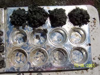
13 SAMPLING REQUIREMENTS DETERMINE SAMPLING REQUIREMENTS - Disturbed samples (cuttings samples) - grainsize - moisture content - lithology for stratigraphic interpretation - etc. - Undisturbed samples (core, shelby tube, etc) - preconsolidation pressures - direct shear - permeability - etc. 63


14 SAMPLING REQUIREMENTS Disturbed Cuttings Collected using sieves, washed and dried on low heat 64

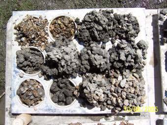

15 SAMPLING REQUIREMENTS Disturbed Cuttings 65

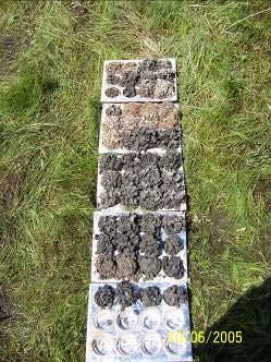
16 SAMPLING REQUIREMENTS Disturbed Cuttings From Auger 66

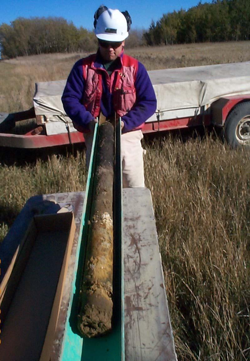
17 SAMPLING REQUIREMENTS Undisturbed Core 67

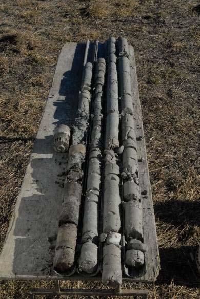
18 SAMPLING REQUIREMENTS Undisturbed Core 68


19 SAMPLING REQUIREMENTS Zone from which water sample was acquired of water sample Undisturbed Core 69

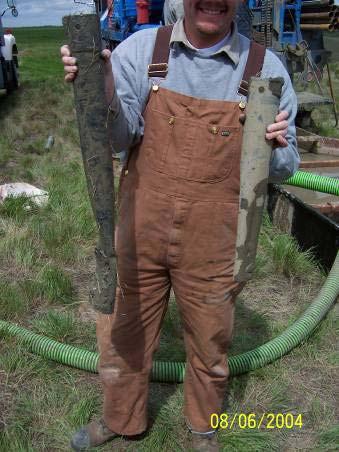
20 SAMPLING REQUIREMENTS Undisturbed Shelby Tube 70


21 GEOPHYSICS Surface geophysics Borehole geophysics 71
22 GEOPHYSICS SURFACE GEOPHYSICS Speed / portability Non intrusive/destructive Near continuous information Relatively simple operation Single or dual person operation 72
23 GEOPHYSICS SURFACE GEOPHYSICS Interference overhead lines, buried lines, any conductors or power sources may mask features of interest Parameter measure of electrical conductivity, NOT of contaminant concentration, geologic material type, fracture spacing, etc. Indirect Measure known benchmarks are required, e.g. outcrops, boreholes, water samples, etc. Need boreholes/piezometers to ground truth data 73
24 GEOPHYSICS SURFACE GEOPHYSICS Factors influencing electrical conductivity: Degree of saturation Degree of compaction Salinity of pore water Soil composition (clay content) 74
25 GEOPHYSICS COMMON SURFACE GEOPHYSICAL METHODS EM 38 EM 31 EM 34 GEM/2 ERT (Electric Resistivity Tomography) 75

26 GEOPHYSICS COMMON SURFACE GEOPHYSICAL METHODS EM 38 For shallow use (about 1.5 m) One person operated Held at approximately ground level 76


27 GEOPHYSICS COMMON SURFACE GEOPHYSICAL METHODS EM 31 Most commonly used Consists of a transmitter coil and a receiver coil with a control unit in the middle 77

28 GEOPHYSICS COMMON SURFACE GEOPHYSICAL METHODS EM 31 Pipeline Location 78

29 GEOPHYSICS COMMON SURFACE GEOPHYSICAL METHODS EM 34 Same principle used as EM31 2-operator system, slower Typically used for mapping groundwater contaminant plumes and for groundwater exploration Measurement depth up to 60 m good to around 20 m 79


30 GEOPHYSICS COMMAN SURFACE GEOPHYSICAL METHODS EM 34 Receiver Transmitter Datalogger 80

31 EM34 Survey E 446,000 E 446,000 E 447,000 E 447,000 E 448,000 E 448, N 5,751,000 N 5,752,000 N 5,753,000 N 5,754,000 N 5,755,000 N 5,751,000 N 5,752,000 N5,753,000 N 5,754,000 N5,755,000 GEOPHYSICS CONDUCTIVITY ms/m
32 GEOPHYSICS COMMON SURFACE GEOPHYSICAL METHODS Electric Resistivity Tomography (ERT) Environmental monitoring and site characterization Detection of groundwater flow and contaminant paths Groundwater exploration Stratigraphic mapping (particularly bedrock topography) 82


33 GEOPHYSICS COMMON SURFACE GEOPHYSICAL METHODS Electric Resistivity Tomography (ERT) 83
34 Electric Resistivity Tomography (ERT) 54 km of ERT line Mapping channel aquifer at industrial site 84
35 GEOPHYSICS Electric Resistivity Tomography (ERT) 420 m Resistivity Slice Industrial Site 85
36 GEOPHYSICS Electric Resistivity Tomography (ERT) 440 m Resistivity Slice Industrial Site 86
37 GEOPHYSICS Electric Resistivity Tomography (ERT) 460 m Resistivity Slice Industrial Site 87
38 GEOPHYSICS Location of Aquifer Electric Resistivity Tomography (ERT) 480 m Resistivity Slice Industrial Site 88

39 Electric Resistivity Tomography (ERT) Able to determine depth to bedrock Great for targeting drill holes Expensive 89
40 GEOPHYSICS BOREHOLE GEOPHYSICS Non biased stratigraphic information Ideal for optimizing placement of instrumentation Help stratigraphic interpretations Provide a continuous record of borehole Certain methods can be completed through installations after hole is drilled 90
41 GEOPHYSICS BOREHOLE GEOPHYSICS Natural Gamma Single Point Resistance Self Potential Caliper Density EM-39 Most Common All sorts of more exotic logging devices for virtually any application 91

42 GEOPHYSICS BOREHOLE GEOPHYSICS EM 39 - Borehole Geophysics 92


43 GEOPHYSICS BOREHOLE GEOPHYSICS NG, SPR, SP 93


44 GEOPHYSICS BOREHOLE GEOPHYSICS NG, SPR, SP 94

45 95
46 LABORATORY TESTING LABORATORY TESTING Used to define material properties in site model There are tests to measure any soil or water property Common laboratory tests used in site characterization include: - Atterberg Limits - Carbonate Content - Compressibility (Preconsolidation( Pressures) - Direct Shear - Triaxial Permeability - Groundwater Chemistry 96
47 LABORATORY TESTING LABORATORY TESTING ATTERBERG LIMITS Are a composite index of clay mineralogy and grainsize distribution in terms of workability of soil under field conditions Provide expected behavior of soils over a range of water contents Most common soil test in the world Can be completed on disturbed samples 97
48 LABORATORY TESTING ATTERBERG LIMITS BRITTLE PLASTIC LIQUID X SHEAR STRESS SHEAR STRESS SHEAR STRESS STRAIN STRAIN STRAIN WATER CONTENT W P I P W L Optimum Water Content For Compaction W P = PLASTIC LIMIT W L = LIQUID LIMIT = SOIL BECOMES LIQUID = NO SHEAR STRENGTH I P = PLASTICITY INDEX THE MORE CLAY THE HIGHER THE NUMBER 98
49 LABORATORY TESTING ATTERBERG LIMITS BRITTLE PLASTIC LIQUID X SHEAR STRESS SHEAR STRESS SHEAR STRESS STRAIN STRAIN STRAIN W n W P W L VERY HARD HARD FIRM SOFT W n = NATURAL WATER CONTENT VERY SOFT LIQUID LIQUIDITY INDEX = W n -W p W n -W L LI = 0 firm near optimum water content = 0.9 is almost a liquid 99
50 LABORATORY TESTING CONSOLIDATION TESTS Determine how a soil will behave to the application of a load Allow prediction of settlement Enable the determination of preconsolidation pressures which can be used to help separate tills Require undisturbed samples 100
ENCE 3610 Soil Mechanics. Site Exploration and Characterisation Field Exploration Methods
 ENCE 3610 Soil Mechanics Site Exploration and Characterisation Field Exploration Methods Geotechnical Involvement in Project Phases Planning Design Alternatives Preparation of Detailed Plans Final Design
Chapter 12 Subsurface Exploration
 Page 12 1 Chapter 12 Subsurface Exploration 1. The process of identifying the layers of deposits that underlie a proposed structure and their physical characteristics is generally referred to as (a) subsurface
Finding Large Capacity Groundwater Supplies for Irrigation
 Finding Large Capacity Groundwater Supplies for Irrigation December 14, 2012 Presented by: Michael L. Chapman, Jr., PG Irrigation Well Site Evaluation Background Investigation Identify Hydrogeologic Conditions
10. GEOTECHNICAL EXPLORATION PROGRAM
 Geotechnical site investigations should be conducted in multiple phases to obtain data for use during the planning and design of the tunnel system. Geotechnical investigations typically are performed in
Gotechnical Investigations and Sampling
 Gotechnical Investigations and Sampling Amit Prashant Indian Institute of Technology Gandhinagar Short Course on Geotechnical Investigations for Structural Engineering 12 14 October, 2017 1 Purpose of
The process of determining the layers of natural soil deposits that will underlie a proposed structure and their physical properties is generally
 The process of determining the layers of natural soil deposits that will underlie a proposed structure and their physical properties is generally referred to as sub surface investigation 2 1 For proper
Connecticut's Aquifers
 Page 1 of 5 DEP Search: Connecticut's Aquifers The technical definition of the word "aquifer" is: any geologic formation capable of yielding significant quantities of water to wells. By that definition,
Geophysics for Environmental and Geotechnical Applications
 Geophysics for Environmental and Geotechnical Applications Dr. Katherine Grote University of Wisconsin Eau Claire Why Use Geophysics? Improve the quality of site characterization (higher resolution and
SCOPE OF INVESTIGATION Simple visual examination of soil at the surface or from shallow test pits. Detailed study of soil and groundwater to a
 Lecture-5 Soil Exploration Dr. Attaullah Shah 1 Today s Lecture Purpose of Soil Exploration Different methods 1. Test trenches and Pits 2. Auger and Wash Boring 3. Rotary Drilling 4. Geophysical Methods
Manual on Subsurface Investigations National Highway Institute Publication No. FHWA NHI Federal Highway Administration Washington, DC
 Manual on Subsurface Investigations National Highway Institute Publication No. FHWA NHI-01-031 Federal Highway Administration Washington, DC Geotechnical Site Characterization July 2001 by Paul W. Mayne,
Module 1 : Site Exploration and Geotechnical Investigation
 Objectives In this section you will learn the following Displacement borings Wash boring Auger boring Rotary drilling Percussion drilling Continuous sampling Boring methods of exploration The boring methods
Boreholes. Implementation. Boring. Boreholes may be excavated by one of these methods: 1. Auger Boring 2. Wash Boring 3.
 Implementation Boreholes 1. Auger Boring 2. Wash Boring 3. Rotary Drilling Boring Boreholes may be excavated by one of these methods: 4. Percussion Drilling The right choice of method depends on: Ground
Geological Mapping using Geophysics
 Geological Mapping using Geophysics Pugin, A.J.M. and T.H. Larson Illinois State Geological Survey, 615 E Peabody Dr., Champaign, IL 61820; E-mail: A.J.M. Pugin at pugin@isgs.uiuc.edu Mapping Techniques.
Site Characterization & Hydrogeophysics
 Site Characterization & Hydrogeophysics (Source: Matthew Becker, California State University) Site Characterization Definition: quantitative description of the hydraulic, geologic, and chemical properties
Table of Contents Chapter 1 Introduction to Geotechnical Engineering 1.1 Geotechnical Engineering 1.2 The Unique Nature of Soil and Rock Materials
 Table of Contents Chapter 1 Introduction to Geotechnical Engineering 1.1 Geotechnical Engineering 1.2 The Unique Nature of Soil and Rock Materials 1.3 Scope of This Book 1.4 Historical Development of Geotechnical
HOW. HOW vehicle mounted units portable units also available. HOW, WHEN & WHY to Geophysically Log in S.I.?
 HOW, WHEN & WHY to Geophysically Log in S.I.? by Kim Beesley HOW HOW vehicle mounted units portable units also available Access to borehole Depth of borehole sump / rat -hole? 1 HOW? - subject to borehole
iii CONTENTS vii ACKNOWLEDGMENTS EXECUTIVE SUMMARY INTRODUCTION Study Area Data Sources Preparation of Geologic Maps
 CONTENTS ACKNOWLEDGMENTS EXECUTIVE SUMMARY INTRODUCTION Study Area Data Sources Preparation of Geologic Maps GEOLOGY Bedrock Geology Succession and Distribution Structural Features Description of Bedrock
Underground Risk Management Course Marina Del Rey, California November, Geotechnical Data Reports. Greg Raines, PE
 Underground Risk Management Course Marina Del Rey, California November, 2018 Geotechnical Data Reports Greg Raines, PE Gregory.Raines@Stantec.com Introduction What is a Geotechnical Data Report? The GDR
patersongroup Design for Earthquakes Consulting Engineers May 19, 2016 File: PG3733-LET.01
 patersongroup May 19, 2016 File: PG3733-LET.01 Hydro Ottawa Limited c/o Cresa Toronto 170 University Avenue, Suite 1 Toronto, Ontario M5H 3B3 Attention: Ms. Barbara Wright Consulting Engineers 154 Colonnade
Introduction to Soil Mechanics Geotechnical Engineering-II
 Introduction to Soil Mechanics Geotechnical Engineering-II ground SIVA Dr. Attaullah Shah 1 Soil Formation Soil derives from Latin word Solum having same meanings as our modern world. From Geologist point
Appendix J. Geological Investigation
 Appendix J Geological Investigation Appendix J Geological Environment Table of Contents Page 1 INTRODUCTION...J-1 1.1 Purpose of the Investigation...J-1 1.2 Scope of the Investigation...J-1 2 METHODO OF
Soil Mechanics Brief Review. Presented by: Gary L. Seider, P.E.
 Soil Mechanics Brief Review Presented by: Gary L. Seider, P.E. 1 BASIC ROCK TYPES Igneous Rock (e.g. granite, basalt) Rock formed in place by cooling from magma Generally very stiff/strong and often abrasive
Geotechnical Properties of Soil
 Geotechnical Properties of Soil 1 Soil Texture Particle size, shape and size distribution Coarse-textured (Gravel, Sand) Fine-textured (Silt, Clay) Visibility by the naked eye (0.05 mm is the approximate
APPENDIX A. Borehole Logs Explanation of Terms and Symbols
 APPENDIX A Borehole Logs Explanation of Terms and Symbols Page 153 of 168 EXPLANATION OF TERMS AND SYMBOLS The terms and symbols used on the borehole logs to summarize the results of field investigation
SHEAR STRENGTH OF SOIL
 Soil Failure Criteria SHEAR STRENGTH OF SOIL Knowledge about the shear strength of soil important for the analysis of: Bearing capacity of foundations, Slope stability, Lateral pressure on retaining structures,
11/22/2010. Groundwater in Unconsolidated Deposits. Alluvial (fluvial) deposits. - consist of gravel, sand, silt and clay
 deposits. - consist of gravel, sand, silt and clay") Groundwater in Unconsolidated Deposits Alluvial (fluvial) deposits - consist of gravel, sand, silt and clay - laid down by physical processes in rivers and flood plains - major sources for water supplies
Groundwater in Unconsolidated Deposits Alluvial (fluvial) deposits - consist of gravel, sand, silt and clay - laid down by physical processes in rivers and flood plains - major sources for water supplies
SITE INVESTIGATION 1
 SITE INVESTIGATION 1 Definition The process of determining the layers of natural soil deposits that will underlie a proposed structure and their physical properties is generally referred to as site investigation.
Geophysical Methods for Screening and Investigating Utility Waste Landfill Sites in Karst Terrain
 Geophysical Methods for Screening and Investigating Utility Waste Landfill Sites in Karst Terrain Gary Pendergrass, PE, RG, F.NSPE Principal Geological Engineer Kansas City Geotechnical Conference 2017
Course Scheme -UCE501: SOIL MECHANICS L T P Cr
 Course Scheme -UCE501: SOIL MECHANICS L T P Cr 3 1 2 4.5 Course Objective: To expose the students about the various index and engineering properties of soil. Introduction: Soil formation, various soil
- Cased-hole geophysical well logs - Airborne geophysics - Seismic data - LiDAR. GeoConvention 2015: New Horizons 1
 Thermal Effects and Quaternary Hydrogeology: Making Good Decisions in a Complex Geologic Setting Timothy Johnsen, Phd, Quaternary Specialist (tjohnsen@matrix-solutions.com) Alex Haluszka, MSc, P.Geol.,
Depth (ft) USCS Soil Description TOPSOIL & FOREST DUFF
 USCS Soil Description TOPSOIL & FOREST DUFF") Test Pit No. TP-6 Location: Latitude 47.543003, Longitude -121.980441 Approximate Ground Surface Elevation: 1,132 feet Depth (ft) USCS Soil Description 0 1.5 1.5 5.0 SM 5.0 8.0 SM Loose to medium dense,
Test Pit No. TP-6 Location: Latitude 47.543003, Longitude -121.980441 Approximate Ground Surface Elevation: 1,132 feet Depth (ft) USCS Soil Description 0 1.5 1.5 5.0 SM 5.0 8.0 SM Loose to medium dense,
Determining In Situ Properties of Claystone Aquitards Using Pore Pressure Responses from Grouted-in Pressure Transducers
 Determining In Situ Properties of Claystone Aquitards Using Pore Pressure Responses from Grouted-in Pressure Transducers Laura A. Smith, S. Lee Barbour, M. Jim Hendry University of Saskatchewan, Saskatoon,
Resistivity & IP methods
 International PhD Course in HYDROGEOPHYSICS Resistivity & IP methods Andrew Binley Lancaster University Overview We have demonstrated links between hydrological and geophysical properties and show the
LECTURE 10. Module 3 : Field Tests in Rock 3.6 GEOPHYSICAL INVESTIGATION
 LECTURE 10 3.6 GEOPHYSICAL INVESTIGATION In geophysical methods of site investigation, the application of the principles of physics are used to the study of the ground. The soil/rock have different characteristics
Azimuthal Resistivity to Characterize Fractures in a Glacial Till. Mark Boris, University of Saskatchewan Jim Merriam, University of Saskatchewan
 Azimuthal Resistivity to Characterize Fractures in a Glacial Till Mark Boris, University of Saskatchewan Jim Merriam, University of Saskatchewan Abstract Azimuthal resistivity was used to characterize
How & Where does infiltration work? Summary of Geologic History Constraints/benefits for different geologic units
 June 26, 2007: Low Impact Development 1 Associated Earth Sciences, Inc. Associated Earth Sciences, Inc. Presented by: Matthew A. Miller, PE April 24, 2012 How & Where does infiltration work? Summary of
Micro Seismic Hazard Analysis
 Micro Seismic Hazard Analysis Mark van der Meijde INTERNATIONAL INSTITUTE FOR GEO-INFORMATION SCIENCE AND EARTH OBSERVATION Overview Site effects Soft ground effect Topographic effect Liquefaction Methods
APPENDIX F CORRELATION EQUATIONS. F 1 In-Situ Tests
 APPENDIX F 1 APPENDIX F CORRELATION EQUATIONS F 1 In-Situ Tests 1. SPT (1) Sand (Hatanaka and Uchida, 1996), = effective vertical stress = effective friction angle = atmosphere pressure (Shmertmann, 1975)
14 Geotechnical Hazards
 Volume 2: Assessment of Environmental Effects 296 14 Geotechnical Hazards Overview This Chapter provides an assessment of the underlying geotechnical conditions to identify: any potential liquefaction
Chapter 5 Shear Strength of Soil
 Page 5 Chapter 5 Shear Strength of Soil. The internal resistance per unit area that the soil mass can offer to resist failure and sliding along any plane inside it is called (a) strength (b) shear strength
(C) Global Journal of Engineering Science and Research Management
 Global Journal of Engineering Science and Research Management") GEOTECHNCIAL ASSESSMENT OF PART OF PORT HARCOURT, NIGER DELTA FOR STRUCTURAL ANALYSIS Warmate Tamunonengiyeofori Geostrat International Services Limited, www.geostratinternational.com. *Correspondence
GEOTECHNCIAL ASSESSMENT OF PART OF PORT HARCOURT, NIGER DELTA FOR STRUCTURAL ANALYSIS Warmate Tamunonengiyeofori Geostrat International Services Limited, www.geostratinternational.com. *Correspondence
Monitoring of In-Situ Chemical Oxidation (ISCO) with Time Series Geophysical Surveys
 with Time Series Geophysical Surveys") Monitoring of In-Situ Chemical Oxidation (ISCO) with Time Series Geophysical Surveys Philip T. Harte, P.G. U.S. Geological Survey ptharte@usgs.gov 603-226-7813 U.S. Department of the Interior U.S. Geological
Monitoring of In-Situ Chemical Oxidation (ISCO) with Time Series Geophysical Surveys Philip T. Harte, P.G. U.S. Geological Survey ptharte@usgs.gov 603-226-7813 U.S. Department of the Interior U.S. Geological
Groundwater Sustainability at Wadi Al Bih Dam, Ras El Khaimah, United Arab Emirates (UAE) using Geophysical methods
 using Geophysical methods") Groundwater Sustainability at Wadi Al Bih Dam, Ras El Khaimah, United Arab Emirates (UAE) using Geophysical methods Ahmed Murad, Amir Gabr, Saber Mahmoud, Hasan Arman & Abdulla Al Dhuhoori Geology Department
Groundwater Sustainability at Wadi Al Bih Dam, Ras El Khaimah, United Arab Emirates (UAE) using Geophysical methods Ahmed Murad, Amir Gabr, Saber Mahmoud, Hasan Arman & Abdulla Al Dhuhoori Geology Department
Soils. Technical English - I 10 th week
 Technical English - I 10 th week Soils Soil Mechanics is defined as the branch of engineering science which enables an engineer to know theoretically or experimentally the behavior of soil under the action
Soil Mechanics. Chapter # 1. Prepared By Mr. Ashok Kumar Lecturer in Civil Engineering Gpes Meham Rohtak INTRODUCTION TO SOIL MECHANICS AND ITS TYPES
 Soil Mechanics Chapter # 1 INTRODUCTION TO SOIL MECHANICS AND ITS TYPES Prepared By Mr. Ashok Kumar Lecturer in Civil Engineering Gpes Meham Rohtak Chapter Outlines Introduction to Soil Mechanics, Soil
Geologic Considerations of Shallow SAGD Caprock; Seal Capacity, Seal Geometry and Seal Integrity, Athabasca Oilsands, Alberta Canada
 Geologic Considerations of Shallow SAGD Caprock; Seal Capacity, Seal Geometry and Seal Integrity, Athabasca Oilsands, Alberta Canada Gordon T. Stabb, Michael Webb Durando Resources Corp, Suncor Energy
Surface Processes Focus on Mass Wasting (Chapter 10)
") Surface Processes Focus on Mass Wasting (Chapter 10) 1. What is the distinction between weathering, mass wasting, and erosion? 2. What is the controlling force in mass wasting? What force provides resistance?
Surface Processes Focus on Mass Wasting (Chapter 10) 1. What is the distinction between weathering, mass wasting, and erosion? 2. What is the controlling force in mass wasting? What force provides resistance?
GPR AS A COST EFFECTIVE BEDROCK MAPPING TOOL FOR LARGE AREAS. Abstract
 GPR AS A COST EFFECTIVE BEDROCK MAPPING TOOL FOR LARGE AREAS Dr. Jutta L. Hager, Hager GeoScience, Inc., Waltham, MA Mario Carnevale, Hager GeoScience, Inc., Waltham, MA Abstract Hager GeoScience, Inc.
Geophysical Exploration in Water Resources Assessment. John Mundell, P.E., L.P.G., P.G. Ryan Brumbaugh, L.P.G. Mundell & Associates, Inc.
 Geophysical Exploration in Water Resources Assessment John Mundell, P.E., L.P.G., P.G. Ryan Brumbaugh, L.P.G. Mundell & Associates, Inc. Presentation Objective Introduce the use of geophysical survey methods
Ground-Water Exploration in the Worthington Area of Nobles County: Summary of Seismic Data and Recent Test Drilling Results
 Ground-Water Exploration in the Worthington Area of Nobles County: Summary of Seismic Data and Recent Test Drilling Results Jim Berg and Todd Petersen Geophysicists, DNR Waters January 2000 Table of Contents
INTRODUCTION TO LOGGING TOOLS
 BY: MUHAMMAD ZAHID INTRODUCTION TO LOGGING TOOLS 1- SPONTANEOUS POTENTIAL (SP) The Spontaneous potential survey, (sp) was one of the first measurements, which was carried out, in a well bore. The SP log
David de Courcy-Bower and Samuel Mohr
 Applicability and Limitations of LNAPL Transmissivity as a Metric within Bedrock Formations Insert then choose Picture select your picture. Right click your picture and Send to back. David de Courcy-Bower
Aquitard Characterization The Legend of Indiana s Magic Clay Layer. Juliet Port, LPG #2214 July 2014
 Aquitard Characterization The Legend of Indiana s Magic Clay Layer Juliet Port, LPG #2214 July 2014 Topics What is an Aquitard? Why do we care? Review of Indiana glacial geology Conceptual Framework Investigation
A. V T = 1 B. Ms = 1 C. Vs = 1 D. Vv = 1
 Geology and Soil Mechanics 55401 /1A (2002-2003) Mark the best answer on the multiple choice answer sheet. 1. Soil mechanics is the application of hydraulics, geology and mechanics to problems relating
Geology and Soil Mechanics /1A ( ) Mark the best answer on the multiple choice answer sheet.
 Mark the best answer on the multiple choice answer sheet.") Geology and Soil Mechanics 55401 /1A (2003-2004) Mark the best answer on the multiple choice answer sheet. 1. Soil mechanics is the application of hydraulics, geology and mechanics to problems relating
Geology and Soil Mechanics 55401 /1A (2003-2004) Mark the best answer on the multiple choice answer sheet. 1. Soil mechanics is the application of hydraulics, geology and mechanics to problems relating
Airborne Geophysics to Map Groundwater. Bill Brown
 Airborne Geophysics to Map Groundwater Bill Brown bb@skytem.com A 6 borehole represents 1 millionth of an acre Aquifer Materials An aquifer is an underground layer of water bearing permeable rock, rock
ambiguity in earth sciences IESO Geophysics Section Eddy hartantyo, Lab Geofisika FMIPA UGM
 ambiguity in earth sciences IESO Geophysics Section Eddy hartantyo, Lab Geofisika FMIPA UGM Pelatihan Tahap II IESO Teknik Geologi UGM Februari 2009 1 Introduction Photos from http://www.eegs.org/whatis/
Prof. Dr.-Ing. Martin Achmus Institute of Soil Mechanics, Foundation Engineering and Waterpower Engineering. Offshore subsoil investigations
 Prof. Dr.-Ing. Martin Achmus Institute of Soil Mechanics, Foundation Engineering and Waterpower Engineering Offshore subsoil investigations Addis Ababa, September 2010 Offshore subsoil investigations Presentation
The Geology and Hydrogeology of the Spyhill Area
 The Geology and Hydrogeology of the Spyhill Area Clare North (WorleyParsons Komex) and Martin Ortiz (The City of Calgary) 2-Jul-08 Outline Background Site Location Existing Information New Work Geology
APPENDIX C Frontier Geoscience Geophysical Survey Report
 Aquifer Mapping Study WL09-1578 Town of Gibsons, British Columbia 13 May 2013 Submitted To The Town of Gibsons APPENDIX C Frontier Geoscience Geophysical Survey Report WATERLINE RESOURCES INC. REPORT ON
1.8 Unconfined Compression Test
 1-49 1.8 Unconfined Compression Test - It gives a quick and simple measurement of the undrained strength of cohesive, undisturbed soil specimens. 1) Testing method i) Trimming a sample. Length-diameter
June 9, R. D. Cook, P.Eng. Soils Engineer Special Services Western Region PUBLIC WORKS CANADA WESTERN REGION REPORT ON
 PUBLIC WORKS CANADA WESTERN REGION REPORT ON GEOTECHNICAL INVESTIGATION PROPOSED MARTIN RIVER BRIDGE MILE 306.7 MACKENZIE HIGHWAY Submitted by : R. D. Cook, P.Eng. Soils Engineer Special Services Western
HYDROGEOLOGICAL PROPERTIES OF THE UG2 PYROXENITE AQUIFERS OF THE BUSHVELD COMPLEX
 R. Gebrekristos, P.Cheshire HYDROGEOLOGICAL PROPERTIES OF THE UG2 PYROXENITE AQUIFERS OF THE BUSHVELD COMPLEX R. Gebrekristos Digby Wells Environmental P. Cheshire Groundwater Monitoring Services Abstract
Chapter 8 Fetter, Applied Hydrology 4 th Edition, Geology of Groundwater Occurrence
 Chapter 8 Fetter, Applied Hydrology 4 th Edition, 2001 Geology of Groundwater Occurrence Figure 8.42. Alluvial Valleys ground-water region. Fetter, Applied Hydrology 4 th Edition, 2001 Fetter, Applied
CONTENTS. 1. GeneralsG Field Investigation WorkG Laboratory Testing Work Surface Soil Description-- 7.
 CONTENTS Page 1. GeneralsG 4 2. Field Investigation WorkG 4 3. Laboratory Testing Work--- 5 4. Surface Soil Description-- 7 Appendix A Borehole Location Plan 11 Soil Profile-- 15 Bore Logs--=---- 18 Appendix
Geology 229 Engineering Geology. Lecture 8. Elementary Soil Mechanics (West, Ch. 7)
") Geology 229 Engineering Geology Lecture 8 Elementary Soil Mechanics (West, Ch. 7) Outline of this Lecture 1. Introduction of soil properties 2. Index properties of soils Soil particles Phase relationship
Geology 229 Engineering Geology Lecture 8 Elementary Soil Mechanics (West, Ch. 7) Outline of this Lecture 1. Introduction of soil properties 2. Index properties of soils Soil particles Phase relationship
GG 454 January 18, SOILS (06)
") GG 454 January 18, 2002 1 SOILS (06) I Main Topics A Pedologic classification schemes B Engineering classification schemes C Behavior of soils and influence of geologic history II Pedologic classification
GG 454 January 18, 2002 1 SOILS (06) I Main Topics A Pedologic classification schemes B Engineering classification schemes C Behavior of soils and influence of geologic history II Pedologic classification
The Ohio Department of Transportation Office of Research & Development Executive Summary Report
 The Ohio Department of Transportation Office of Research & Development Executive Summary Report Shear Strength of Clay and Silt Embankments Start Date: January 1, 2007 Duration: 2 Years- 10 Months Completion
Lower Mainland Surficial Geology From Wisconsin Ice Age to Protocol 21
 Lower Mainland Surficial Geology From Wisconsin Ice Age to Protocol 21 BCEIA BEST Conference 2018 Whistler, BC Kalina Malowany and Virginie Brunetaud Presentation Outline 1. Surficial Geology it s more
Liquefaction Resistance and Internal Erosion Potential of Non-Plastic Silty Sand
 Liquefaction Resistance and Internal Erosion Potential of Non-Plastic Silty Sand Jing-Wen CHEN 1, Wei F. LEE 2, Chun-Chi CHEN 3 1 Professor, Department of Civil Engineering, National Chen-Kung University
BOREHOLE GEOPHYSICAL LOGGING IN UNCONSOLIDATED SEDIMENTS -AN AID TO 3-D 3 D MAPPING. J.A. Hunter Geological Survey of Canada
 BOREHOLE GEOPHYSICAL LOGGING IN UNCONSOLIDATED SEDIMENTS -AN AID TO 3-D 3 D MAPPING J.A. Hunter Geological Survey of Canada QUALITATIVE PARAMETERS - grain size - sediment type - porosity - density - pore-water
The attitude he maintains in his relation to the engineer is very well stated in his own words:
 Su bsurface Soil Exploration, 53: 139 Foundation Engineering Geotechnical companies that have a history of experience in a given region usually have extensive boring logs and maps telling where the borings
Basin Analysis Applied to Modelling Buried Valleys in the Great Lakes Basin
 EARTH SCIENCES SECTOR GENERAL INFORMATION PRODUCT 35 Basin Analysis Applied to Modelling Buried Valleys in the Great Lakes Basin Sharpe, D R; Russell, H A J 2004 Originally released as: Basin Analysis
PHYSICO-MECHANICAL PROPERTIES OF ROCKS LECTURE 2. Contents
 PHYSICO-MECHANICAL PROPERTIES OF ROCKS LECTURE 2 Contents 2.1 Introduction 2.2 Rock coring and logging 2.3 Physico-mechanical properties 2.3.1 Physical Properties 2.3.1.1 Density, unit weight and specific
Case Study: University of Connecticut (UConn) Landfill
 Landfill") Case Study: University of Connecticut (UConn) Landfill Problem Statement:» Locate disposal trenches» Identify geologic features and distinguish them from leachate and locate preferential pathways in fractured
Case Study: University of Connecticut (UConn) Landfill Problem Statement:» Locate disposal trenches» Identify geologic features and distinguish them from leachate and locate preferential pathways in fractured
2-D Resistivity Study: The Horizontal Resolution Improvement by Introducing the Enhancing Horizontal Resolution (EHR) Technique
 Technique") Open Journal of Geology, 213, 3, 1-6 doi:1.4236/ojg.213.32b1 Published Online April 213 (http://www.scirp.org/journal/ojg) 2-D Resistivity Study: The Horizontal Resolution Improvement by Introducing the
Open Journal of Geology, 213, 3, 1-6 doi:1.4236/ojg.213.32b1 Published Online April 213 (http://www.scirp.org/journal/ojg) 2-D Resistivity Study: The Horizontal Resolution Improvement by Introducing the
CCR Rule Compliance: Innovative Use of Geophysics to Certify Landfill Stability and Site Groundwater Monitoring Wells
 CCR Rule Compliance: Innovative Use of Geophysics to Certify Landfill Stability and Site Groundwater Monitoring Wells Gary Pendergrass, PE, RG Principal Geological Engineer Missouri Waste Control Coalition
 QUESTION BANK DEPARTMENT: CIVIL SUBJECT CODE / Name: CE 2251 / SOIL MECHANICS SEMESTER: IV UNIT 1- INTRODUCTION PART - A (2 marks) 1. Distinguish between Residual and Transported soil. (AUC May/June 2012)
Scholars Research Library
 Available online at www.scholarsresearchlibrary.com Scholars Research Library Archives of Physics Research, 2010, 1 (2):37-45 (http://scholarsresearchlibrary.com/archive.html) ISSN 0976-0970 2-D Resistivity
 UNIT I SITE INVESTIGATION AND SELECTION OF FOUNDATION Types of boring 1.Displacement borings It is combined method of sampling & boring operation. Closed bottom sampler, slit cup, or piston type is forced
4. Soil Consistency (Plasticity) (Das, chapter 4)
 (Das, chapter 4)") 4. Soil Consistency (Plasticity) (Das, chapter 4) 1 What is Consistency? Consistency is a term used to describe the degree of firmness of fine-grained soils (silt and clay). The consistency of fine grained
4. Soil Consistency (Plasticity) (Das, chapter 4) 1 What is Consistency? Consistency is a term used to describe the degree of firmness of fine-grained soils (silt and clay). The consistency of fine grained
Engineering Geologic Conditions for Trenchless Application in the Denver Metro Area
 North American Society for Trenchless Technology (NASTT) NASTT s 2015 No-Dig Show Denver, Colorado March 15-19, 2015 Paper WM-T4-03 Engineering Geologic Conditions for Trenchless Application in the Denver
Objectives: Define Relative Age, Absolute Age
 S6E5. Students will investigate the scientific view of how the earth s surface is formed. c. Classify rocks by their process of formation. g. Describe how fossils show evidence of the changing surface
Site Investigations and Geotechnical Risk For Underground Construction Greg Raines, PE
 August 14, 2017 Site Investigations and Geotechnical Risk For Underground Construction Greg Raines, PE Gregory.Raines@Stantec.com Develop Preliminary Geologic / Geotech Conceptual Model for the Project
Influence of Paleochannels on Seepage
 Study 4 Influence of Paleochannels on Seepage Public Draft 2014 Monitoring and Analysis Plan September 2013 August 2012 Influence of Paleochannels on Seepage 1. Statement of Need Historical maps, aerial
Introduction to Soil Mechanics
 Introduction to Soil Mechanics Sela Sode and Colin Jones WILEY Blackwell Contents Preface Dedication and Acknowledgments List of Symbols Soil Structure 1.1 Volume relationships 1.1.1 Voids ratio (e) 1.1.2
SOME OBSERVATIONS RELATED TO LIQUEFACTION SUSCEPTIBILITY OF SILTY SOILS
 SOME OBSERVATIONS RELATED TO LIQUEFACTION SUSCEPTIBILITY OF SILTY SOILS Upul ATUKORALA 1, Dharma WIJEWICKREME 2 And Norman MCCAMMON 3 SUMMARY The liquefaction susceptibility of silty soils has not received
Landslide FE Stability Analysis
 Landslide FE Stability Analysis L. Kellezi Dept. of Geotechnical Engineering, GEO-Danish Geotechnical Institute, Denmark S. Allkja Altea & Geostudio 2000, Albania P. B. Hansen Dept. of Geotechnical Engineering,
H.1 SUMMARY OF SUBSURFACE STRATIGRAPHY AND MATERIAL PROPERTIES (DATA PACKAGE)
") DRAFT ONONDAGA LAKE CAPPING AND DREDGE AREA AND DEPTH INITIAL DESIGN SUBMITTAL H.1 SUMMARY OF SUBSURFACE STRATIGRAPHY AND MATERIAL PROPERTIES (DATA PACKAGE) Parsons P:\Honeywell -SYR\444576 2008 Capping\09
DRAFT ONONDAGA LAKE CAPPING AND DREDGE AREA AND DEPTH INITIAL DESIGN SUBMITTAL H.1 SUMMARY OF SUBSURFACE STRATIGRAPHY AND MATERIAL PROPERTIES (DATA PACKAGE) Parsons P:\Honeywell -SYR\444576 2008 Capping\09
RIVERS, GROUNDWATER, AND GLACIERS
 RIVERS, GROUNDWATER, AND GLACIERS Delta A fan-shaped deposit that forms when a river flows into a quiet or large body of water, such as a lake, an ocean, or an inland sea. Alluvial Fan A sloping triangle
Groundwater Hydrology
 EXERCISE 12 Groundwater Hydrology INTRODUCTION Groundwater is an important component of the hydrologic cycle. It feeds lakes, rivers, wetlands, and reservoirs; it supplies water for domestic, municipal,
KDOT Geotechnical Manual Edition. Table of Contents
 KDOT Geotechnical Manual 2007 Edition The KDOT Geotechnical Manual is available two volumes. Both volumes are very large electronic (pdf) files which may take several minutes to download. The table of
Module 1 GEOTECHNICAL PROPERTIES OF SOIL AND OF REINFORCED SOIL (Lectures 1 to 4)
") Module 1 GEOTECHNICAL PROPERTIES OF SOIL AND OF REINFORCED SOIL (Lectures 1 to 4) Topics 1.1 INTRODUCTION 1.2 GRAIN-SIZE DISTRIBUTION Sieve Analysis Hydrometer Analysis 1.3 SIZE LIMITS FOR SOILS 1.4 WEIGHT-VOLUME
Module 1 GEOTECHNICAL PROPERTIES OF SOIL AND OF REINFORCED SOIL (Lectures 1 to 4) Topics 1.1 INTRODUCTION 1.2 GRAIN-SIZE DISTRIBUTION Sieve Analysis Hydrometer Analysis 1.3 SIZE LIMITS FOR SOILS 1.4 WEIGHT-VOLUME
Name. 4. The diagram below shows a soil profile formed in an area of granite bedrock. Four different soil horizons, A, B, C, and D, are shown.
 Name 1. In the cross section of the hill shown below, which rock units are probably most resistant to weathering? 4. The diagram below shows a soil profile formed in an area of granite bedrock. Four different
J. Paul Guyer, P.E., R.A.
 J. Paul Guyer, P.E., R.A. Paul Guyer is a registered mechanical engineer, civil engineer, fire protection engineer and architect with over 35 years experience in the design of buildings and related infrastructure.
Michigan s Geology and Groundwater
 Michigan s Geology and Groundwater Ralph J. Haefner Deputy Director U.S. Geological Survey Michigan-Ohio Water Science Center Lansing, Michigan Outline About the USGS Geology 101 Michigan s geology Bedrock
 SOIL CLASSIFICATION CHART COARSE-GRAINED SOILS MORE THAN 50% RETAINED ON NO.200 SIEVE FINE-GRAINED SOILS 50% OR MORE PASSES THE NO.200 SIEVE PRIMARY DIVISIONS GRAVELS MORE THAN 50% OF COARSE FRACTION RETAINED
Chapter 14: Groundwater. Fig 14.5b
 Chapter 14: Groundwater Fig 14.5b OBJECTIVES Recognize that groundwater is a vital source of accessible freshwater. Describe how groundwater forms below the water table. Explain the origin of aquifers,
Collapsible Soils Definitions
 Collapsible Soils Definitions Collapsible soils are also known as metastable soils. They are unsaturated soils that undergo a large volume change upon saturation. The sudden and usually large volume change
Geotechnical Investigation and Monitoring Results of a Landslide Failure at Southern Peninsular Malaysia (Part 1: Investigating Causes of Failure)
") Geotechnical Investigation and Monitoring Results of a Landslide Failure at Southern Peninsular Malaysia (Part 1: Investigating Causes of Failure) Liew, S. S., Gue, S. S., Liong, C. H. Director, Gue &
Geotechnical Investigation and Monitoring Results of a Landslide Failure at Southern Peninsular Malaysia (Part 1: Investigating Causes of Failure) Liew, S. S., Gue, S. S., Liong, C. H. Director, Gue &