Geophysics for Environmental and Geotechnical Applications
|
|
|
- Olivia Hart
- 5 years ago
- Views:
Transcription
1 Geophysics for Environmental and Geotechnical Applications Dr. Katherine Grote University of Wisconsin Eau Claire
2 Why Use Geophysics? Improve the quality of site characterization (higher resolution and increased area covered) Reduce the cost of site characterization Non invasive Provides a method to optimally locate exploratory boreholes Cost effective means of establishing control between boreholes
3 Geophysical Techniques: Seismic Electromagnetic Resistivity Ground Penetrating Radar Magnetic Gravity

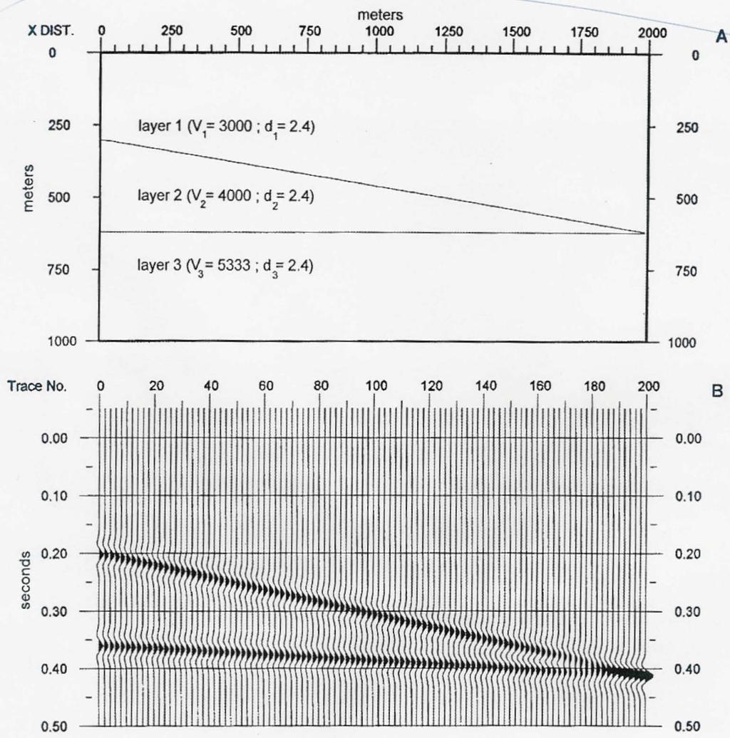
4 Seismic Refraction An acoustic source is discharged at the earth s surface. Energy travels directly to the sensors or is critically refracted from prominent subsurface interfaces and is recorded by sensors placed at multiple locations. The travel times (arrival times) of direct and refracted acoustic energy are plotted as a function of source sensor separation.
5 Seismic Refraction If the subsurface is irregular, sources are discharged at multiple locations (typically five). This multiplicity of travel time data allows depths to be estimated with a higher degree of precision.
6 Seismic Refraction From An Introduction to Applied and Environmental Geophysics, by John Reynolds, 2007.
7 Seismic Refraction Applications: Depth to bedrock Depth to water table Bedrock type Bedrock rippability Mapping bedrock interfaces Mapping bedrock channels Identifying faults and fracture zones


8 Seismic Refraction 2 D refraction data can often be transformed into realistic 2 D geologic models. The accuracy of such models will be increased if external constraints (borehole control) are available. Note that low velocity layers are invisible and never imaged with refraction techniques. From: Handbook of Ripping, 8th Edition, by The Caterpillar Company
9 Seismic Refraction Strengths: Provides accurate 2-D or 3-D subsurface images Provides information on material type Data acquisition is straightforward Data processing and interpretation are straightforward Less expensive Limitations: Depth penetration depends on source used; simplest sources have relatively shallow depth penetration Relatively slow data acquisition, as sensors (geophones) must be coupled to the ground Data are difficult to interpret beyond ~4 interfaces Low velocity layers and thin layers (<3 m) cannot be distinguished Doesn t work well in acoustically noisy areas
10 Seismic Reflection An acoustic pulse is generated by a surface source. Some of this downgoing energy is reflected at each subsurface interface. The two way travel time and magnitude of the reflected pulses are recorded by surface receivers (geophones). Magnitudes and average velocities of the reflected pulses are a function of the density and acoustic velocity of the subsurface layers..
11 Seismic Reflection


12 Seismic Reflection Three dimensional seismic reflection surveys are becoming more common for environmental and engineering applications. The data acquisition and processing are much more complicated than for 2 D reflection or refraction surveying.

13 (b) Seismic Reflection (a) 2 D reflection profiles can be converted into 2 D lithology/structure sections.
14 Seismic Reflection Strengths (compared to refraction): Can provide continuous images of the subsurface structure Can image low-velocity layers Better lateral resolution (used for finding abandoned underground mines) Can provide 3-D image of the subsurface Limitations (compared to refraction): Cannot image shallow layers ( 15 m) Data acquisition is slower Data processing is much more complicated Much more expensive (typically 3 to 5 times more expensive than refraction surveys)
.")
15 Electromagnetic Methods (EM) The electromagnetic induction process is conceptually summarized in figure 1 from Klein and Lajoie (1980).
16 Electromagnetic Methods (EM) 1. When AC current is passed through a coiled wire conductor (transmitter), EM radiation (primary field) of the same frequency is emitted from the coil. 2. When this primary EM radiation passes through a subsurface conductor, a secondary AC current is induced in the conductor. 3. This secondary current causes the conductor to emit secondary EM radiation. 4. This secondary EM radiation is measured and recorded by the receiver coil. The apparent electrical conductivity is determined by comparing the magnitudes of the primary and secondary EM fields.


17 Electromagnetic Methods (EM) Measure the earth s response to EM radiation Map spatial variations in the electrical conductivity of the subsurface Electrical conductivity can be related to soil or rock properties

18 Electromagnetic Methods (EM) Applications: Depth to bedrock Depth to water table Mapping contaminant plumes Landfill delineation Locating USTs Locating buried utilities Mapping clay lenses Mapping faults, fractures, or weathered zones Variations in porosity, saturation, or salinity Mapping salt water intrusion
19 Electromagnetic Methods (EM) Strengths: Do not need to be coupled to earth, so data can be acquired rapidly and inexpensively Data can often be acquired by one person Multiple tools available (simple to sophisticated) Limitations: Vertical resolution diminishes with depth Cultural features can create problems (metal fences, buried pipelines, electric power lines, etc.) Provides 1-D, 2-D or 3-D conductivity images of subsurface, depending on technique used
20 Resistivity A known AC current (I) is input into the ground using a battery or a generator, and potential differences ( V) are measured using a voltmeter. The resistance (R) of the subsurface can be calculated using the wellknown formula: V = IR Current flow in the subsurface is electrolytic (via the movement of cations and anions) rather than electronic. The resistivity (ρ) of the subsurface is calculated by considering the geometric arrangement of electrodes.
21 Resistivity The resistivity of the subsurface at different locations and at different depths can be measured by shifting the array laterally and varying the electrode spacing. ΔV A ΔV B expandable electrode array A B C D E... Location along traverse Depth ρ values

22 Resistivity Resistivity is the inverse of electrical conductivity and is an intrinsic property of a material. Resistivity is mostly a function of lithology, porosity, clay content, permeability, fluid saturation and fluid salinity.

23 Applications: Resistivity Lateral and vertical mapping of contaminant plumes Mapping sand and gravel aquifers Mapping clay layers and lenses Depth to bedrock Depth to water table Mapping faults, fractures, weathered zones Delineating aggregate deposits for quarry operations Mapping lithologic contacts Locate voids, abandoned mines and tunnels Variations in porosity, saturation, or salinity
24 Strengths: Acquisition is relatively straightforward Resistivity Limitations: Relatively slow, as electrodes must be coupled to ground surface Processing is automated Can provide relatively highresolution 2-D or 3-D conductivity images of subsurface Coupling can be a problem (rock or dry sand) Limited depth penetration (typically 30 m); deeper penetration depths require larger horizontal electrode spacing Resolution diminishes with depth Cultural features can create problems (metal fences, buried pipelines, electric power lines, etc.)
25 Ground Penetrating Radar (GPR) Transmitter emits pulses of EM radiation at regular intervals as it is towed across the surface. Some of this pulsed energy is reflected from lithologic interfaces and is returned to the earth s surface. The two way travel time and magnitude of this reflected pulsed radiation is recorded by a surface receiver and plotted on a distance vs. travel time profile.


26 Ground Penetrating Radar (GPR)

27 Ground Penetrating Radar (GPR)
28 Ground Penetrating Radar (GPR) Applications: Mapping lithology or fill boundaries Depth to shallow bedrock Depth to water table Mapping water depths (surface water) Location, depth, and orientation of USTs, pipes, utilities, trenches, and other buried materials Locating cavities beneath pavement Measuring pavement thickness Locating rebar in concrete Bridge deck integrity studies Archeological and forensic investigations Mapping contaminant plumes
29 Ground Penetrating Radar (GPR) Strengths: Limitations: Acquisition is rapid and straightforward Data can be acquired by one person Does not need to be coupled to ground Can provide very high-resolution images of the subsurface Targets do not need to be conductive or metallic Does not work well in clays or conductive soils (low depth penetration) Less effective in rough or cluttered terrain Requires a contrast in dielectric permittivity (primarily controlled by water content) to generate reflections Limited depth penetration ( 30 m)
30 Magnetic North Pole Magnetic Techniques - + The total magnetic field at any observation point on the earth s surface is the sum of the earth s primary magnetic field (caused by circulation of fluid in the outer core) and any proximal secondary magnetic fields (generated by materials that have become slightly magnetized in the presence of the earth s magnetic field (mostly iron bearing or magnetite bearing material)). We are usually only interested in the secondary magnetic field, which can be found by subtracting the contribution of the primary magnetic field from the measured total magnetic field.
31 Magnetic Techniques Secondary magnetic fields (ΔB) associated with man made iron based materials are usually very easy to identify, because they are relatively high magnitude and stand out. ΔB ( B T B E ) Theoretically, we can estimate the size, shape and depth of the causative body based on the width, shape, and magnitude of the residual magnetic curve (ΔB). surface Anomaly with high concentration of iron However, secondary magnetic field anomalies (ΔB) are usually interpreted qualitatively instead of quantitatively in part because they are often very complex.
 Regional geologic mapping Rebar in concrete Archeological investigations Locating underwater ferromagnetic")
32 Magnetic Techniques Applications: Locating buried drums, pipelines and other ferromagnetic objects Locating buried well casings Locating/mapping landfills Locating sand and gravel deposits (that contain heavy minerals) Regional geologic mapping Rebar in concrete Archeological investigations Locating underwater ferromagnetic objects
33 Magnetic Techniques Strengths: Data can be acquired by one person Does not need to be coupled to ground, so data can be acquired quickly and inexpensively Data are usually interpreted qualitatively and therefore require minimal post-acquisition processing Limitations: Cannot locate non-ferrous materials such as plastic or concrete Magnetic signatures are superposed (cannot distinguish nearby targets) Anomalies are generally very complex and may be extremely difficult to interpret quantitatively Utilities, power lines, buildings, and metallic debris can cause interference The size and depth of objects affect detectability
34 Gravity Gravity is not uniform. It is a function of the mass of the earth, the mean radius of the earth, the angular velocity of the earth, the elevation of the observation location, and surface topography in proximity to the observation location. g directed towards center of mass It also varies because of small scale density variations within the earth s crust (variable depth to bedrock, presence of voids, variations in lithology, etc.). Gravimeters are generally used to measure relative variations in the earth s gravitational field. Normally, we re only interested in variations that are caused by subsurface geological
35 Gravity Reduced Gravity Profile Δg ( g m g Φ ) surface isolated anomaly Residual (isolated) gravity anomalies are often interpreted quantitatively Ideally, we can estimate size, shape, depth & density of the causative feature based on the width, shape & amplitude of residual anomaly curve subsurface void To isolate local variations in gravity (the residual gravity anomalies), the measured gravity is corrected to account for changes in latitude, elevation, etc.

36 Gravity Applications: Estimating depth to bedrock Determining in situ rock/soil densities Mapping air filled cavities in karst terrain Mapping abandoned underground mines Estimating tonnage of ore Determining volumes of available fill Measuring changes in water table elevation
37 Strengths: Gravity Limitations: Data can be acquired by one person Only respond to changes in density (not affected by electrical or magnetic noise), so can be acquired in urban areas Data can be interpreted quantitatively - model (depth, shape, size, density) of target can often be generated Relatively slow data acquisition Data interpretation requires control parameters (i.e. background density) Data interpretation can be time consuming Very precise surveying control is required so that elevation and latitude corrections can be applied Gravity signatures are superposed (cannot distinguish nearby targets)
38 Final notes: Geophysical data can greatly improve site characterization and can reduce costs, but Many geophysical techniques provide nonunique results unless they are constrained by borehole or other information. Use geophysical techniques in conjunction with ground truth measurements!
39 Final notes: The success of a geophysical survey depends on planning the survey appropriately for the site share all available information with the geophysicists before they arrive on site! Using multiple geophysical techniques is often the most efficient method for accurate site characterization.
1. Resistivity of rocks
 RESISTIVITY 1) Resistivity of rocks 2) General principles of resistivity surveying 3) Field procedures, interpretation and examples 4) Summary and conclusions INDUCED POLARIZATION 1) General principles
ambiguity in earth sciences IESO Geophysics Section Eddy hartantyo, Lab Geofisika FMIPA UGM
 ambiguity in earth sciences IESO Geophysics Section Eddy hartantyo, Lab Geofisika FMIPA UGM Pelatihan Tahap II IESO Teknik Geologi UGM Februari 2009 1 Introduction Photos from http://www.eegs.org/whatis/
High Resolution Geophysics: A Better View of the Subsurface. By John Jansen, P.G., Ph.D., Aquifer Science and Technology
 High Resolution Geophysics: A Better View of the Subsurface By John Jansen, P.G., Ph.D., Aquifer Science and Technology Geologist Use Only Part of the Information Available To Them Most Geologist rely
Applied Geophysics for Environmental Site Characterization and Remediation
 Applied Geophysics for Environmental Site Characterization and Remediation MSECA Webinar September 24, 2015 John Mundell, P.E., L.P.G. Ryan Brumbaugh, L.P.G. MUNDELL & ASSOCIATES, INC. Webinar Objective
INTRODUCTION TO APPLIED GEOPHYSICS
 INTRODUCTION TO APPLIED GEOPHYSICS EXPLORING THE SHALL0W SUBSURFACE H. Robert Burger Anne F. Sheehan Craig H.Jones VERSITY OF COLORADO VERSITY OF COLORADO W. W. NORTON & COMPANY NEW YORK LONDON Contents
Site Characterization & Hydrogeophysics
 Site Characterization & Hydrogeophysics (Source: Matthew Becker, California State University) Site Characterization Definition: quantitative description of the hydraulic, geologic, and chemical properties
LECTURE 10. Module 3 : Field Tests in Rock 3.6 GEOPHYSICAL INVESTIGATION
 LECTURE 10 3.6 GEOPHYSICAL INVESTIGATION In geophysical methods of site investigation, the application of the principles of physics are used to the study of the ground. The soil/rock have different characteristics
Electrical Surveying (part A)
") Electrical Surveying (part A) Dr. Laurent Marescot Course given at the University of Fribourg (2009) Contact: laurent@tomoquest.com www.tomoquest.com 1 Introduction Electrical surveying Resistivity method
Electrical Surveying (part A) Dr. Laurent Marescot Course given at the University of Fribourg (2009) Contact: laurent@tomoquest.com www.tomoquest.com 1 Introduction Electrical surveying Resistivity method
Major Points in Introduction
 Near- Surface Processes and Resources John Louie - louie@seismo.unr.edu eismo. unr.edu Thomas Pratt tpratt@ocean.washington.edu ashington.edu Here is a Laundry List- With it, we can prioritize Major Points
GEOPHYSICAL SITE CHARACTERIZATION IN SUPPORT OF HIGHWAY EXPANSION PROJECT
 GEOPHYSICAL SITE CHARACTERIZATION IN SUPPORT OF HIGHWAY EXPANSION PROJECT * Shane Hickman, * Todd Lippincott, * Steve Cardimona, * Neil Anderson, and + Tim Newton * The University of Missouri-Rolla Department
Application of Ground Penetrating Radar for hydro-geological study
 Journal of Scientific & Industrial Research Vol. 65, February 2006, pp. 160-164 Application of Ground Penetrating Radar for hydro-geological study K K K Singh* Central Mining Research Institute, Dhanbad
Geophysics for Land Development
 Geophysics for Land Development About Us Whatever your area of interest GBGMAPS can provide advanced subsurface and structural geophysical solutions to add value to your product. Mining and infrastructure
Geophysics Course Introduction to DC Resistivity
 NORAD supported project in MRRD covering Capacity Building and Institutional Cooperation in the field of Hydrogeology for Faryab Province Afghanistan Geophysics Course Introduction to DC Resistivity By
CONTENTS 1. INTRODUCTION. 2. THE D.C. RESISTIVITY METHOD 2.1 Equipment 2.2 Survey Procedure 2.3 Data Reduction
 (i) CONTENTS 1. INTRODUCTION page 1 2. THE D.C. RESISTIVITY METHOD 2.1 Equipment 2.2 Survey Procedure 2.3 Data Reduction 3 3 3 3 3. GEOPHYSICAL RESULTS 3.1 General 3.2 Discussion 4 4 4 4. LIMITATIONS 5
Geoelectricity. ieso 2010
 Geoelectricity ieso 2010 1 RESISTIVITY SURVEY AT VENETO VILLA GRITTI AT THE TOWN OF TREVISO (VENETO REGION) The survey was carried out to verify the underground presence of the fondations of a rustic building.
Instructional Objectives
 GE 6477 DISCONTINUOUS ROCK 8. Fracture Detection Dr. Norbert H. Maerz Missouri University of Science and Technology (573) 341-6714 norbert@mst.edu Instructional Objectives 1. List the advantages and disadvantages
Ground subsidence is a worldwide problem especially
 Ground Engineering: GPR A Case Study on Ground Subsidence Using Ground Penetrating Radar Nur Azwin Ismail and Rosli Saad Geophysics Section, School of Physics, Universiti Sains Malaysia Ground subsidence
EXTREMELY FAST IP USED TO DELINEATE BURIED LANDFILLS. Norman R. Carlson, Cris Mauldin Mayerle, and Kenneth L. Zonge
 EXTREMELY FAST IP USED TO DELINEATE BURIED LANDFILLS Norman R. Carlson, Cris Mauldin Mayerle, and Kenneth L. Zonge Zonge Engineering and Research Organization, Inc. 3322 East Fort Lowell Road Tucson, Arizona,
FINAL REPORT GEOPHYSICAL INVESTIGATION WATER TOWER NO. 6 SITE PLANT CITY, FL
 APPENDIX B FINAL REPORT GEOPHYSICAL INVESTIGATION WATER TOWER NO. 6 SITE PLANT CITY, FL Prepared for Madrid Engineering Group, Inc. Bartow, FL Prepared by GeoView, Inc. St. Petersburg, FL February 28,
An Introduction to Applied and Environmental Geophysics
 An to Applied and Environmental Geophysics 2nd Edition John M. Reynolds Reynolds International Ltd Preface to the 2 na Edition Acknowledgements 1 1.1 1.2 1.3 1.4 1.5 What are 'applied' and 'environmental'
SASKATCHEWAN STRATIGRAPHY GLACIAL EXAMPLE BOULDERS IN GLACIAL DEPOSITS
 SASKATCHEWAN STRATIGRAPHY GLACIAL EXAMPLE BOULDERS IN GLACIAL DEPOSITS 51 SASKATCHEWAN STRATIGRAPHY GLACIAL SURFICIAL STRATIFIED DEPOSITS 52 SASKATCHEWAN STRATIGRAPHY GLACIAL EXAMPLE OF SEDIMENT DEPOSITION
MOUNT POLLEY MINING CORPORATION TECHNICAL REPORT ON MULTI-ELECTRODE RESISTIVITY AND SEISMIC REFRACTION SURVEYS MOUNT POLLEY TAILINGS DAM PROJECT
 MOUNT PLEY MINING CORPORATION TECHNICAL REPORT ON MULTI-ELECTRODE RESISTIVITY AND SEISMIC REFRACTION SURVEYS MOUNT PLEY TAILINGS DAM PROJECT LIKELY, B.C. by Claudia Krumbiegel, M.Sc. Cliff Candy, P.Geo.
Electrical prospecting involves detection of surface effects produced by electrical current flow in the ground.
 Electrical Surveys in Geophysics Electrical prospecting involves detection of surface effects produced by electrical current flow in the ground. Electrical resistivity method Induced polarization (IP)
Electrical Methods. Resistivity Surveying
 Electrical Methods Resistivity Surveying Geologic Resistivity 1101 Resistivity surveying investigates variations of electrical resistance, by causing an electrical current to flow through the subsurface
Geophysical Applications GPR Ground Penetrating Radar
 Overview: Basics of GPR Radar-wave velocity, attenuation and skin depth Modes of acquisition The Radar-range equation Dielectric properties of materials and relation to porosity Case studies [Archeology,
Lima Project: Seismic Refraction and Resistivity Survey. Alten du Plessis Global Geophysical
 Lima Project: Seismic Refraction and Resistivity Survey Alten du Plessis Global Geophysical Report no 0706/2006 18 December 2006 Lima Project: Seismic Refraction and Resistivity Survey by Alten du Plessis
An Introduction to Geophysical Exploration
 An Introduction to Geophysical Exploration Philip Kearey Department of Earth Sciences University of Bristol Michael Brooks Ty Newydd, City Near Cowbridge Vale of Glamorgan Ian Hill Department of Geology
Case Study: University of Connecticut (UConn) Landfill
 Landfill") Case Study: University of Connecticut (UConn) Landfill Problem Statement:» Locate disposal trenches» Identify geologic features and distinguish them from leachate and locate preferential pathways in fractured
Case Study: University of Connecticut (UConn) Landfill Problem Statement:» Locate disposal trenches» Identify geologic features and distinguish them from leachate and locate preferential pathways in fractured
ERDC/GSL TN-14-1 August 2014 Electromagnetic Induction Survey of the Mississippi River in Cleveland, Mississippi
 Electromagnetic Induction Survey of the Mississippi River in Cleveland, Mississippi By Joseph B. Dunbar and Maureen K. Corcoran PURPOSE: This study was conducted in support of Mississippi State University
A Case Study on Ground Subsidence Using Ground Penetrating Radar
 2012 International Conference on Environmental, Biomedical and Biotechnology IPCBEE vol.41 (2012) (2012) IACSIT Press, Singapore A Case Study on Ground Using Ground Penetrating Radar Nur Azwin Ismail +
Global Geophysical. Geophysical Service Solutions
 Geophysical Service Solutions is a geophysical consultancy firm specializing in providing geophysical solutions to appropriate mining, environmental and engineering problems. Site-appropriate geophysical
ENVIRONMENTAL AND ENGINEERING GEOPHYSICS
 ENVIRONMENTAL AND ENGINEERING GEOPHYSICS Environmental Engineering MSc 08/09 nd semester COURSE COMMUNICATION DOCUMENT University of Miskolc Faculty of Earth Science and Engineering Institute of Geophysics
Geophysical Exploration in Water Resources Assessment. John Mundell, P.E., L.P.G., P.G. Ryan Brumbaugh, L.P.G. Mundell & Associates, Inc.
 Geophysical Exploration in Water Resources Assessment John Mundell, P.E., L.P.G., P.G. Ryan Brumbaugh, L.P.G. Mundell & Associates, Inc. Presentation Objective Introduce the use of geophysical survey methods
GPR surveys at Nõmmküla Detection of underground water routes
 GPR surveys at Nõmmküla 2009 Detection of underground water routes Tomi Herronen & Timo Saarenketo 2009 1. Introduction The purpose of this survey was to locate possible underground water routes (rivers)
Groundwater Sustainability at Wadi Al Bih Dam, Ras El Khaimah, United Arab Emirates (UAE) using Geophysical methods
 using Geophysical methods") Groundwater Sustainability at Wadi Al Bih Dam, Ras El Khaimah, United Arab Emirates (UAE) using Geophysical methods Ahmed Murad, Amir Gabr, Saber Mahmoud, Hasan Arman & Abdulla Al Dhuhoori Geology Department
Groundwater Sustainability at Wadi Al Bih Dam, Ras El Khaimah, United Arab Emirates (UAE) using Geophysical methods Ahmed Murad, Amir Gabr, Saber Mahmoud, Hasan Arman & Abdulla Al Dhuhoori Geology Department
TRC1504: Alternative Uses of Ground Penetrating Radar in Highway in Construction and Maintenance. Elisha Wright-Kehner, P.E.
 TRC1504: Alternative Uses of Ground Penetrating Radar in Highway in Construction and Maintenance Elisha Wright-Kehner, P.E. Why GPR? Practicality Non-invasive (Non-destructive Testing - NDT) Real-time
ELECTRICAL RESISTIVITY TOMOGRAPHY
 NOTIO Association Clay Technological Centre C/ Río Cabriel s/n 45007 Toledo Tel.: 925 24 11 62 info@notio.es www.notio.es Page 1 / 7 SUMMARY 1. PHYSICAL FUNDAMENTALS OF THE... 3 1.1. ELECTRICAL BEHAVIOR
KARST MAPPING WITH GEOPHYSICS AT MYSTERY CAVE STATE PARK, MINNESOTA
 KARST MAPPING WITH GEOPHYSICS AT MYSTERY CAVE STATE PARK, MINNESOTA By Todd A. Petersen and James A. Berg Geophysics Program Ground Water and Climatology Section DNR Waters June 2001 1.0 Summary A new
FUNDAMENTALS OF ENGINEERING GEOLOGY
 FUNDAMENTALS OF ENGINEERING GEOLOGY Prof. Dr. HUSSEIN HAMEED KARIM Building and Construction Engineering Department 2012 Preface The impulse to write this book stemmed from a course of geology given by
Module 1 : Site Exploration and Geotechnical Investigation
 Objectives In this section you will learn the following Displacement borings Wash boring Auger boring Rotary drilling Percussion drilling Continuous sampling Boring methods of exploration The boring methods
Geothermal Energy Resources Exploration using Gravity and magnetics. By Mariita, N.O. KenGen
 Geothermal Energy Resources Exploration using Gravity and magnetics By Mariita, N.O. KenGen What is Geothermal Energy? Geothermal Energy = heat from the Earth Transmitted by fluids via fractures and pores
2-D Resistivity Study: The Horizontal Resolution Improvement by Introducing the Enhancing Horizontal Resolution (EHR) Technique
 Technique") Open Journal of Geology, 213, 3, 1-6 doi:1.4236/ojg.213.32b1 Published Online April 213 (http://www.scirp.org/journal/ojg) 2-D Resistivity Study: The Horizontal Resolution Improvement by Introducing the
Open Journal of Geology, 213, 3, 1-6 doi:1.4236/ojg.213.32b1 Published Online April 213 (http://www.scirp.org/journal/ojg) 2-D Resistivity Study: The Horizontal Resolution Improvement by Introducing the
UTC R189 GEOPHYSICAL ASSESSMENT OF KARST ACTIVITY. Neil L. Anderson
 GEOPHYSICAL ASSESSMENT OF KARST ACTIVITY by Neil L. Anderson UTC R189 A University Transportation Center Program at Missouri University of Science & Technology Disclaimer The contents of this report reflect
PART A: Short-answer questions (50%; each worth 2%)
") PART A: Short-answer questions (50%; each worth 2%) Your answers should be brief (just a few words) and may be written on these pages if you wish. Remember to hand these pages in with your other exam pages!
PART A: Short-answer questions (50%; each worth 2%) Your answers should be brief (just a few words) and may be written on these pages if you wish. Remember to hand these pages in with your other exam pages!
Site characterization at the Groundwater Remediation Field Laboratory
 Site characterization at the Groundwater Remediation Field Laboratory WILLIAM P. C LEMENT, STEVE CARDIMONA, ANTHONY L. ENDRES, Boston College, Boston, Massachusetts KATHARINE KADINSKY-CADE, Phillips Laboratory,
POTASH DRAGON CHILE GEOPHYSICAL SURVEY TRANSIENT ELECTROMAGNETIC (TEM) METHOD. LLAMARA and SOLIDA PROJECTS SALAR DE LLAMARA, IQUIQUE, REGION I, CHILE
 METHOD. LLAMARA and SOLIDA PROJECTS SALAR DE LLAMARA, IQUIQUE, REGION I, CHILE") POTASH DRAGON CHILE GEOPHYSICAL SURVEY TRANSIENT ELECTROMAGNETIC (TEM) METHOD LLAMARA and SOLIDA PROJECTS SALAR DE LLAMARA, IQUIQUE, REGION I, CHILE OCTOBER 2012 CONTENT Page I INTRODUCTION 1 II FIELD
POTASH DRAGON CHILE GEOPHYSICAL SURVEY TRANSIENT ELECTROMAGNETIC (TEM) METHOD LLAMARA and SOLIDA PROJECTS SALAR DE LLAMARA, IQUIQUE, REGION I, CHILE OCTOBER 2012 CONTENT Page I INTRODUCTION 1 II FIELD
Geophysical Site Investigation (Seismic methods) Amit Prashant Indian Institute of Technology Gandhinagar
 Amit Prashant Indian Institute of Technology Gandhinagar") Geophysical Site Investigation (Seismic methods) Amit Prashant Indian Institute of Technology Gandhinagar Short Course on Geotechnical Aspects of Earthquake Engineering 04 08 March, 2013 Seismic Waves
Geophysical Site Investigation (Seismic methods) Amit Prashant Indian Institute of Technology Gandhinagar Short Course on Geotechnical Aspects of Earthquake Engineering 04 08 March, 2013 Seismic Waves
Principles of Applied Geophysics
 Principles of Applied Geophysics Fifth edition D.S. Parasnis Professor emeritus of Applied Geophysics Department of Applied Geophysics, University ofluled, Lulea, Sweden Fellow of the Royal Swedish Academy
Hazard Mapping Along the Dead Sea Shoreline
 FIG Working Week in Marrakech, Morocco 18-22 May 2011 Hazard Mapping Along the Dead Sea Shoreline Rami Al-Ruzouq, Abdullah Al-Zuobi, AbdEl-Rahman Abueladas, Emad Akkawi Department of Surveying and Geomatics
Geological Mapping using Geophysics
 Geological Mapping using Geophysics Pugin, A.J.M. and T.H. Larson Illinois State Geological Survey, 615 E Peabody Dr., Champaign, IL 61820; E-mail: A.J.M. Pugin at pugin@isgs.uiuc.edu Mapping Techniques.
Lesson 1 Introduction to geophysical methods Emanuele Forte
 Lesson 1 Introduction to geophysical methods Emanuele Forte 3 rd September 2016 Naxos, Greece 1 Outline - What is Geophysics - Base concepts: (Geo)Physical parameters Sensitivity Resolution - Active and
Marine Geophysical Methods: What Can and Cannot Be Done to Iden8fy Hazards to Dredging & Marine Construc8on
 Marine Geophysical Methods: What Can and Cannot Be Done to Iden8fy Hazards to Dredging & Marine Construc8on Marine Geophysics Sham or Savior? Seen alternatively as the silver bullet or snake oil, marine
Surface and borehole electrical resistivity tomography
 Surface and borehole electrical resistivity tomography Laurent Marescot laurent@tomoquest.com Introduction Surface electrical resistivity surveying is based on the principle that the distribution of electrical
Last Time. Today s s Agenda. Geophysics. Geophysics. Geophysics. MAS 603: Geological Oceanography. Lecture 21: Geophysics 1: Gravity
 UNIVERSITY OF SOUTH ALABAMA Last Time MAS 603: Geological Oceanography Extinctions Lecture 21: 1: http://www.cartoonstock.com/newscartoons/cartoonists/for/lowres/forn441l.jpg Today s s Agenda Introduction
DATA ACQUISITION METHODS FOR GROUNDWATER INVESTIGATION AND THE SITING OF WATER SUPPLY WELLS
 DATA ACQUISITION METHODS FOR GROUNDWATER INVESTIGATION AND THE SITING OF WATER SUPPLY WELLS M.B.J. Foster Tetra Tech EM Inc., San Francisco, CA, USA Keywords: Groundwater, water wells, drilled wells, geophysical
 12 10 8 6 4 2 0 40-50 50-60 60-70 70-80 80-90 90-100 Fresh Water What we will cover The Hydrologic Cycle River systems Floods Groundwater Caves and Karst Topography Hot springs Distribution of water in
Geophysics foundations: Seeing underground: Introduction
 Introduction Outline This five page article was written for those involved in the earth sciences who have no background in geophysics. It is intended to explain very briefly how applied geophysics can
SEISMIC RADAR AND ELECTRICAL TECHNIQUES FOR WASTE DISPOSAL ASSESSMENT. M. Pipan, G. Dal Moro, E. Forte & M. Sugan
 SEISMIC RADAR AND ELECTRICAL TECHNIQUES FOR WASTE DISPOSAL ASSESSMENT M. Pipan, G. Dal Moro, E. Forte & M. Sugan Department of Geological, Environmental and Marine Sciences, University of Trieste Via Weiss,
Introduction. Electrical surveying. Resistivity method Induced polarization method (IP) Self-potential (SP) method
 Self-potential (SP) method") Introduction Electrical surveying Resistivity method Induced polarization method (IP) Self-potential (SP) method Higher frequency methods (electromagnetic surveys): Electromagnetic induction methods Ground
Introduction Electrical surveying Resistivity method Induced polarization method (IP) Self-potential (SP) method Higher frequency methods (electromagnetic surveys): Electromagnetic induction methods Ground
Although most karstic regions
 Urban Geophysics: Geophysical Signature of Mount Bonnell Fault and Its Karstic Features in Austin, TX by Mustafa Saribudak, Environmental Geophysics Associates, Austin, TX Although most karstic regions
B7 Applications of DC resistivity exploration
 B7 Applications of DC resistivity exploration Modern DC resistivity surveys collect data for generating a 2-D or 3-D geoelectric model of the Earth. A simple 1-D analysis does not often yield results that
Available online Journal of Scientific and Engineering Research, 2016, 3(2):1-7. Research Article
:1-7. Research Article") Available online www.jsaer.com, 2016, 3(2):1-7 Research Article ISSN: 2394-2630 CODEN(USA): JSERBR Assessment of the Reliability of Magnetic Method to Delineate Geologic Features in a Basement Complex:
Available online www.jsaer.com, 2016, 3(2):1-7 Research Article ISSN: 2394-2630 CODEN(USA): JSERBR Assessment of the Reliability of Magnetic Method to Delineate Geologic Features in a Basement Complex:
Imaging VTEM Data: Mapping Contamination Plumes In Tarlton, South Africa
 Imaging VTEM Data: Mapping Contamination Plumes In Tarlton, South Africa M. Combrinck Geotech Airborne Limited Summary VTEM data were acquired during a test survey flown over the Tarlton region in South
Geophysics of Exploration for Water. Geoelectric methods III. edited by Peter Vass
 Geophysics of Exploration for Water Geoelectric methods III edited by Peter Vass The phenomenon of induced polarization was already noticed at the early stage of applying direct current electrical methods
Comparison of Two Geophysical Methods to Investigate Sand and Gravel Deposits, a Case Study in Chumphuang District, Nakhornratchasima, Thailand
 Australian Journal of Basic and Applied Sciences, 7(7): 761-767, 2013 ISSN 1991-8178 Comparison of Two Geophysical Methods to Investigate and Gravel Deposits, a Case Study in Chumphuang District, Nakhornratchasima,
LOCATING AND CHARACTERIZING ABANDONED MINES USING MICROGRAVITY by Richard C. Benson 1, Ronald D. Kaufmann 1, Lynn Yuhr 1, Richard Hopkins 2 ABSTRACT
 LOCATING AND CHARACTERIZING ABANDONED MINES USING MICROGRAVITY by Richard C. Benson 1, Ronald D. Kaufmann 1, Lynn Yuhr 1, Richard Hopkins 2 ABSTRACT Surface geophysical methods can be an important part
Magnetotelluric (MT) Method
 Method") Magnetotelluric (MT) Method Dr. Hendra Grandis Graduate Program in Applied Geophysics Faculty of Mining and Petroleum Engineering ITB Geophysical Methods Techniques applying physical laws (or theory) to
Magnetotelluric (MT) Method Dr. Hendra Grandis Graduate Program in Applied Geophysics Faculty of Mining and Petroleum Engineering ITB Geophysical Methods Techniques applying physical laws (or theory) to
Geophysical mapping and imaging of soil structures: basic overview
 Geophysical mapping and imaging of soil structures: basic overview Stéphane Garambois Landslide team, LGIT, Université Joseph Fourier 3D imaging of the water table (seismic) Geophysical methods 1 Plan
Hamed Aber 1 : Islamic Azad University, Science and Research branch, Tehran, Iran. Mir Sattar Meshin chi asl 2 :
 Present a Proper Pattern for Choose Best Electrode Array Based on Geological Structure Investigating in Geoelectrical Tomography, in order to Get the Highest Resolution Image of the Subsurface Hamed Aber
Application of geophysical results to designing bridge. over a large fault
 Application of geophysical results to designing bridge over a large fault Ho-Joon Chung 1, Jung-Ho Kim 2, Keun-Pil Park 2, Hyoung-Seok Kwon 1, Ho-Sik Choi 3, Ki-Seog Kim 4, Jong-Soo Kim 5 1 Manager, HeeSong
Near-Surface Seismic Reflection Applications
 Near-Surface Seismic Reflection Applications Don Steeples, The University of Kansas, Lawrence, KS USA Abstract Nonintrusive methods of gaining knowledge about the Earth s subsurface comprise several of
Geotechnical verification of impact compaction
 PII-73 Geotechnical verification of impact compaction P. J. Waddell1, R. A. Moyle2 & R. J. Whiteley1 1 2 Coffey Geotechnics, Sydney, Australia Coffey Geotechnics, Harrogate, UK Abstract Remediation of
Engineering Geophysical Application to Mine Subsidence Risk Assessment
 Engineering Geophysical Application to Mine Subsidence Risk Assessment By: Kanaan Hanna, Sr. Mining Engineer Steve Hodges, Sr. Geophysicist Jim Pfeiffer, Sr. Geophysicist Dr. Keith Heasley, Professor West
First Field Test of NAPL Detection with High Resolution Borehole Seismic Imaging
 1 First Field Test of NAPL Detection with High Resolution Borehole Seismic Imaging Jil T. Geller, John E. Peterson, Kenneth H. Williams, Jonathan B. Ajo!Franklin*, and Ernest L. Majer Earth Sciences Division,
GRAVITY AND MAGNETIC METHODS
 Presented at Short Course IX on Exploration for Geothermal Resources, organized by UNU-GTP, GDC and KenGen, at Lake Bogoria and Lake Naivasha, Kenya, Nov. 2-24, 2014. Kenya Electricity Generating Co.,
A Study of Uphole to Determine the Shooting Medium for Seismic Reflection Survey at Himalayan Foot Hill Area
 A Study of Uphole to Determine the Shooting Medium for Seismic Reflection Survey at Himalayan Foot Hill Area Summary Binode Chetia Frontier Basins, ONGC, Dehradun E-mail: chetia_binode@ongc.co.in Acquiring
Seismoelectric Ground-flow DC-4500 Locator
 Seismoelectric Ground-flow DC-4500 Locator Introduction The seismoelectric survey is a new technology combined the electro kinetic potential method and geophysical technology. It is applied directly to
Geophysical Investigation of a 19th Century Archeological Site, Boston College K. Corcoran, J. Hager, M. Carnevale
 Geophysical Investigation of a 19th Century Archeological Site, Boston College K. Corcoran, J. Hager, M. Carnevale Hager GeoScience, Inc., Waltham, MA ------------------------------------------------------------------------
GEOL4714 Final Exam Fall 2005, C. H. Jones instructor
 GEOL4714 Final Exam Fall 2005 p. 1 GEOL4714 Final Exam Fall 2005, C. H. Jones instructor Name: Student ID #: Feel free to use the back of the sheets for answers needing more space. (1) (10 pts) For each
Chapter 12 Subsurface Exploration
 Page 12 1 Chapter 12 Subsurface Exploration 1. The process of identifying the layers of deposits that underlie a proposed structure and their physical characteristics is generally referred to as (a) subsurface
3. Magnetic Methods / 62
 Contents Preface to the Second Edition / xv Excerpts from Preface to the FirstEdition / xvii Mathematical Conventions / xix 1. Introduction / 1 Reference / 5 2. Gravity Methods / 6 2. I. Introduction /
5 Further Case Histories
 5 Further Case Histories Chapter outline Cavity/old workings detection Detailed pillar detection Near-surface cavity detection Dyke, sill and fault detection In-seam disruptions (lenses, etc.) Coal thickness
THE 4Gs IN PRACTICE: INVESTIGATING HOW THE 4Gs ARE APPLIED IN THE OIL & GAS INDUSTRY
 THE 4Gs IN PRACTICE: INVESTIGATING HOW THE 4Gs ARE APPLIED IN THE OIL & GAS INDUSTRY Society for Underwater Technology, Evening Technical Meeting 14 AUGUST 2013 GEOPHYSICS & PORT DEVELOPMENTS EXPLORING
INTERGRATED GEOPHYSICAL METHODS USED TO SITE HIGH PRODUCER GEOTHERMAL WELLS
 Presented at Short Course VII on Exploration for Geothermal Resources, organized by UNU-GTP, GDC and KenGen, at Lake Bogoria and Lake Naivasha, Kenya, Oct. 27 Nov. 18, 2012. GEOTHERMAL TRAINING PROGRAMME
Geo-imaging: An Introduction to Engineering Geophysics
 Geo-imaging: An Introduction to Engineering Geophysics Chih-Ping Lin Distinguished Professor, Department of Civil Engineering & Natural Hazard Mitigation Research Center National Chiao Tung University,
Chapter 10 - Geology. Earth s Structure, Geologic Hazards, and Soils
 Chapter 10 - Geology Earth s Structure, Geologic Hazards, and Soils Plate Tectonics Earth crust (or lithosphere) is broken up into plates that shift and slide around Asthenosphere (semi molten layer of
Seismic Surveying. Dr. Laurent Marescot. Course given at the University of Fribourg (2009) Contact:
 Contact:") Seismic Surveying Dr. Laurent Marescot Course given at the University of Fribourg (2009) Contact: laurent@tomoquest.com 1 Introduction Seismic surveying Investigation based on the propagation of man-made
Seismic Surveying Dr. Laurent Marescot Course given at the University of Fribourg (2009) Contact: laurent@tomoquest.com 1 Introduction Seismic surveying Investigation based on the propagation of man-made
The fields of application of the Ground Penetrating Radar (GPR) are: CONSTRUCTION APPLICATIONS
 are: CONSTRUCTION APPLICATIONS") I.Industrial (technical) applications of geophysical methods used by the Archeo-geophysics laboratory in construction, plumbing, geotechnical engineering, engineering geology, mining, electricity power
I.Industrial (technical) applications of geophysical methods used by the Archeo-geophysics laboratory in construction, plumbing, geotechnical engineering, engineering geology, mining, electricity power
Beyond Rippability A Case History Integrating Seismic Refraction, Electrical Resistivity Imaging, and Geotechnical Boring Logs
 Beyond Rippability A Case History Integrating Seismic Refraction, Electrical Resistivity Imaging, and Geotechnical Boring Logs Jonathan B. Shawver 1 (jb@geovision.com), William Dalrymple 1 (will@geovision.com),
Unexploded Ordnance on Auckland s Doorstep. WasteMINZ November 2017
 Unexploded Ordnance on Auckland s Doorstep WasteMINZ November 2017 Scope Site Background. Site Assessment. Geophysical Survey. Investigation. Findings. Challenges. Key Points. Weiti Bay Site Access Road
Development of geophysical investigation for verifying treatment efficiency of underground cavities
 Development of geophysical investigation for verifying treatment efficiency of underground cavities Hasan A. Kamal* Kuwait Institute for Scientific Research, Infrastructure Risk and Reliability Program,
GM 1.4. SEG/Houston 2005 Annual Meeting 639
 storage recovery project in Leyden, Colorado Kristofer Davis *, Yaoguo Li, Michael Batzle, and Bob Raynolds** Center for Gravity, Electrical, and Magnetic Studies, Department of Geophysics, Colorado School
FINAL REPORT GEOPHYSICAL INVESTIGATION VILLAGE ALHAMBRA RETENTION POND SITE THE VILLAGES, FLORIDA
 FINAL REPORT GEOPHYSICAL INVESTIGATION VILLAGE ALHAMBRA RETENTION POND SITE THE VILLAGES, FLORIDA Prepared for Andreyev Engineering, Inc. Oxford, FL Prepared by GeoView, Inc. St. Petersburg, FL August
SEISMIC REFRACTION INVESTIGATION OF THE SUBSURFACE STRUCTURE AT THE SOUTHERN PART OF NIGER STATE COLLEGE OF EDUCATION, MINNA, NIGERIA
 Bayero Journal of Pure and Applied Sciences, 3(2): 56-6 Received: May, 200 Accepted: October, 200 ISSN 2006-6996 SEISMIC REFRACTION INVESTIGATION OF TE SUBSURFACE STRUCTURE AT TE SOUTERN PART OF NIGER
SEISMIC SURVEY METHODS
 SEISMIC SURVEY METHODS Seismic methods Seismic surveys are used in geology and geotechnical engineering to: a) define the depth of the bedrock; b) investigate the landslide areas, c) check the structural
 SHEET TITLE: DRAWN BY: J.M.CLARK FILE NO. CHECKED BY: W.S. JORDAN APPROVED BY: DATE: FIGURE SHEET TITLE: DRAWN BY: J.M.CLARK FILE NO. CHECKED BY: W.S. JORDAN APPROVED BY: DATE: FIGURE SPOTLIGHT Technical
Chapter 1 Introduction
 Chapter 1 Introduction 1.1 Statement of the Problem Engineering properties of geomaterials are very important for civil engineers because almost everything we build - tunnels, bridges, dams and others
Walkaway Seismic Experiments: Stewart Gulch, Boise, Idaho
 Walkaway Seismic Experiments: Stewart Gulch, Boise, Idaho Lee M. Liberty Center for Geophysical Investigation of the Shallow Subsurface Boise State University Boise, Idaho 1. Summary CGISS conducted walkaway
SURVEYING FOR GOLD. Page 1 of 25
 SURVEYING FOR GOLD Page 1 of 25 Page 2 of 25 Contents Introduction to Lozar Radar... 4 The Ground Penetrating Radar (GPR) system and Methodology... 4 Lozar Radar Surveying for Gold... 7 How Lozar Radar
CHARACTERIZATION OF SOIL PROFILE OF DHAKA CITY USING ELECTRICAL RESISTIVITY TOMOGRAPHY (ERT)
") CHARACTERIZATION OF SOIL PROFILE OF DHAKA CITY USING ELECTRICAL RESISTIVITY TOMOGRAPHY (ERT) Mehedi Ahmed ANSARY 1, B.S. Pushpendue BISWAS 2 and Abul KHAIR 3 1 Professor, Department of Civil Engineering
CHARACTERIZATION OF SOIL PROFILE OF DHAKA CITY USING ELECTRICAL RESISTIVITY TOMOGRAPHY (ERT) Mehedi Ahmed ANSARY 1, B.S. Pushpendue BISWAS 2 and Abul KHAIR 3 1 Professor, Department of Civil Engineering