CONTENTS 1. INTRODUCTION. 2. THE D.C. RESISTIVITY METHOD 2.1 Equipment 2.2 Survey Procedure 2.3 Data Reduction
|
|
|
- Dorthy McDonald
- 5 years ago
- Views:
Transcription
1
2
3 (i) CONTENTS 1. INTRODUCTION page 1 2. THE D.C. RESISTIVITY METHOD 2.1 Equipment 2.2 Survey Procedure 2.3 Data Reduction GEOPHYSICAL RESULTS 3.1 General 3.2 Discussion LIMITATIONS 5 TABLES Table 1 Field Resistivity Data location Page 6 ILLUSTRATIONS Figure 1 Figure 2 Figure 3 Figure 4 Survey Location Plan Site Plan Resistivity Traverse RL-I Resistivity Traverse RL-J location Page 2 Appendix Appendix Appendix
4 1 1. INTRODUCTION In the period August 1 to August 4, 2014, a D.C resistivity profiling survey was carried out on behalf of Blackwater Explorations Ltd. on claim in the Cariboo Mining District. The purpose of the investigation was to expand on previous surveying * and provide some evidence for the existence of a potential, southwest-northeast extension of the paleo-channel on the property. This elongate, topographic low feature was identified by inspection of satellite imagery and located by traversing the numerous logging roads in the area. A Survey Location Plan of the area is shown at a scale of 1:200,000 in Figure 1. Direct current resistivity measurements of ground conditions were completed along the linear, channel-like feature for approximately 600 metres (Line I). Line J was surveyed along logging road 11-K and at right angles to the topographic feature and Line J. A Site Pan illustrating the locations of previous and current resistivity traverses is shown at a 1:50,000 scale in Figure 2, in the Appendix. Apparent resistivity measurements were recorded at 18 locations, with the spacing between readings maintained at 50 m intervals. Recorded resistance readings were converted to apparent resistivities for each 50 m station along the traverse. * Blackwater Explorations Ltd., Resistivity Profiling Survey, Placer Gold Exploration, Quesnel, B.C., September, Russell A. Hillman, P.Eng. Project BLK-570/2 * Blackwater Explorations Ltd., Resistivity Profiling Survey, Placer Gold Exploration, Quesnel, B.C., April, Russell A. Hillman, P.Eng. Project Blk-570/3 * Blackwater Explorations Ltd., Resistivity Profiling Survey, Placer Gold Exploration, Quesnel, B.C., August, Russell A. Hillman, P.Eng. Project Blk-570/4 * Blackwater Explorations Ltd., Resistivity Profiling Survey, Placer Gold Exploration, Quesnel, B.C., April, Russell A. Hillman, P. Eng. Project BLK-570/5
5 N SURVEY AREA N N N N N N N E E E E E E E KILOMETRES BLACKWATER EXPLORATIONS BLACKWATER PROJECT ELECTRICAL RESISTIVITY SURVEY SURVEY LOCATION PLAN DATE: AUGUST 2014 SCALE 1:200,000 FIG. 1
6 3 2. THE D.C. RESISTIVITY METHOD 2.1 Equipment The D.C. resistivity survey was carried out using an ABEM SAS-300B electrical resistivity system, with the associated interconnect cables and stainless steel electrodes. The purpose of the electrical surveying was to determine the subsurface resistivity distribution by recording measurements on the ground surface. The ground resistivity is related to various geological parameters such as the clay mineral and fluid content, porosity, and degree of water saturation in overburden layering and the underlying bedrock. Wenner soundings were obtained by applying a direct current or very low frequency synchronous alternating current to the ground through a pair of electrodes and measuring the resulting potential established by this current across a second set of electrodes. Electrical noise originating from industrial currents or natural earth currents are significantly reduced by the use of synchronous detection incorporated in the design of the SAS-300B, in which the transmitter current and receiver polarity are reversed periodically at a frequency of less than one Hertz. Noise, which is asynchronous with the switching frequency, is then averaged out. 2.2 Survey Procedure Field procedure consisted of driving 4 stainless steel metal electrodes into the shallow subsurface at intervals of 50 metres along the ground surface. Electrical current was then applied to the exterior two electrodes with the resulting potential in volts, recorded by the interior pair of electrodes. In the Wenner array, the spacing between the four in-line electrodes is the same. In this investigation, the a spacing between the electrodes was maintained at 50 metres. Resistance readings were recorded over several cycles of the measuring circuit, until a stable, constant value was confirmed for the reading. 2.3 Data Reduction Standard geometric factors exist for common electrode arrays such as Wenner, Schlumberger and Dipole-Dipole. In the Wenner array, the geometric factor is 2 a, where a is the electrode spacing. In this survey, the electrode spacing was maintained at 50 metres. In order to obtain resistivity values at each location, the geometric factor was multiplied by the recorded resistance reading in ohms.
7 4 3. GEOPHYSICAL RESULTS 3.1 General The results of the resistivity traversing of lines RL-I and RL-J are illustrated at 1:1000 horizontal and 1:5000 vertical scales in Figures 3 and 4 in the Appendix. Line RL-I was approximately 600 m in length, with the smaller crossline RL-J only 300 m in length. The data for the two resistivity lines is listed in Table 1 on Page Discussion The resistivity data for line RL-I displays significant variations, from a minimum of approximately 75,400 ohm-m, to a maximum of about 293,740 ohm-m. The significant feature on the section is the broad resistivity low that extends from station I2 to station I5. Calculated resistivities within this zone are quite consistent, and vary from a minimum of 75,398 ohm-m to a maximum of 101,787 ohm-m. The breadth of this low resistivity zone is approximately 150 metres. The lower resistivities within this zone suggest that bedrock is deeper than along the balance of the traverse. If bedrock was shallower and was within the nominal 40 m penetration depth of the survey, the resistivity value would be considerably higher. Apart from station I1 where the bedrock is believed to be shallow, the bedrock surface from station I5 to I10 is believed to rise to the south-southeast. A moderate deepening of the bedrock likely occurs at stations I11 to I12. The relatively short resistivity traverse for line RL-J in Figure 4 shows resistivity values undulating around an average resistivity of about 65,500 ohm-m. All resistivity values however, are well above the I2 to I5 low resistivity zone on line RL-I. The six values recorded along RL-J likely indicate that the bedrock surface is hummocky along this segment of the 11-K logging road.
8 5 4. LIMITATIONS D.C. resistivity surveys are successful providing adequate contrasts exist in the subsurface in electrical resistivity between distinct geological materials. Also affecting resistivity are the degree of saturation of materials and the porosity, the concentration of dissolved electrolytes, the temperature and the amount and composition of colloids. Conductors identified in resistivity surveying are diverse and depending on geological settings, may include mineralization, graphite, argillite, shear or fault zones, clay beds, marl, saturated materials, clay till, mineralized leachate and zones of salt water intrusion. Electrically resistive materials include but are not limited to, sand and gravel, dry soils, underground voids and competent bedrock. The highest resistivities are generally recorded in crystalline rock. With few exceptions, no unique resistivity value defines a specific geological material. Penetration depths may be affected by the presence of highly conductive surficial materials that may partially mask deeper geological layering. In addition, the resolution of the resistivity method decreases exponentially with depth. In this survey, penetration depths are estimated to be of the order of 40 metres. Given the diffuse nature of the method resolution is inherently poorer at a depth greater than one wavelength. The survey results can also be influenced by electrode coupling, presence of noise and man-made infrastructure such as pipes, fences, power lines and buried metallic objects. The resistivity values measured with the ABEM Terrameter are accurate and repeatable. The electronically-isolated transmitter sends out well-defined, regulated signal currents. The receiver discriminates noise and measures voltages correlated with the transmitter signal current. Receiver measurements at discrete time intervals are recorded when eddy currents, IP and cable transients decay. The unique integrator and measurement strategy embodied in the Terrameter allows extraction of the signal from natural occurring telluric currents, electrochemical variations at the potential electrodes and power transmission lines. The information in this report is based upon geophysical measurements and field procedures. The data for each individual reading was combined to obtain apparent resistivity. No interpretations or analysis into layer depths, thicknesses and true resistivities was carried out on the data. The results are technical in nature and are considered to be a reasonably accurate presentation of existing apparent resistivities within the limitations of the D.C. Resistivity method. Russell Hillman, P.Eng.
9 6 Table 1 Field Resistivity Data Station No. I1 I2 I3 I4 I5 I6 I7 I8 I9 I10 I11 I12 Line RL-I Resistance (ohms) Resistivity (ohm -m) 293, ,736 90,432 75,360 75, , , , , , , ,028 Station No. J1 J2 J3 J4 J5 J6 Line RL-J Resistance (ohms) Resistivity (ohm -m) 168, , , , , ,990
10
11 RL-D EXT. RL-H RL-C RL-D RL-G RL-J F R A S E R R I V E R RL-I RL F RL E RL-A RL-B LEGEND AUGUST 2014 RESISTIVITY LINE APRIL 2014 RESISTIVITY LINE AUGUST 2013 RESISTIVITY LINE METRES BLACKWATER EXPLORATIONS BLACKWATER PROJECT ELECTRICAL RESISTIVITY SURVEY APRIL 2013 RESISTIVITY LINE SITE PLAN 2012 RESISTIVITY LINE DATE: AUGUST 2014 SCALE 1:50,000 FIG. 2
12 SSW NNE I I I I RESISTIVITY (ohm-m) I I I I I I METRES I4 I NNE 20NNE 40NNE 60NNE 80NNE 100NNE 120NNE 140NNE 160NNE 180NNE 200NNE 220NNE 240NNE 260NNE 280NNE 300NNE 320NNE 340NNE 360NNE 380NNE 400NNE 420NNE 440NNE 460NNE 480NNE 500NNE 520NNE 540NNE 560NNE 580NNE 600NNE DISTANCE (metres) BLACKWATER EXPLORATIONS BLACKWATER PROJECT ELECTRICAL RESISTIVITY SURVEY RESISTIVITY TRAVERSE RL-I (2014) DATE: AUGUST 2014 VSCALE 1:5,000 HSCALE 1:1,000 FIG. 3
13 E W J RESISTIVITY (ohm-m) J1 J2 J5 J J W 20W 40W 60W 80W 100W 120W 140W 160W 180W 200W 220W 240W 260W 280W 300W DISTANCE (metres) METRES BLACKWATER EXPLORATIONS BLACKWATER PROJECT ELECTRICAL RESISTIVITY SURVEY RESISTIVITY TRAVERSE RL-J (2014) DATE: AUGUST 2014 VSCALE 1:5,000 HSCALE 1:1,000 FIG. 4
14 BLACKWATER EXPLORATIONS LTD. REPORT ON RESISTIVITY PROFILING SURVEY PLACER GOLD EXPLORATION QUESNEL AREA, B.C. Latitude N Longitude W by Russell A. Hillman, P.Eng. April, 2014 PROJECT BLK-570/5
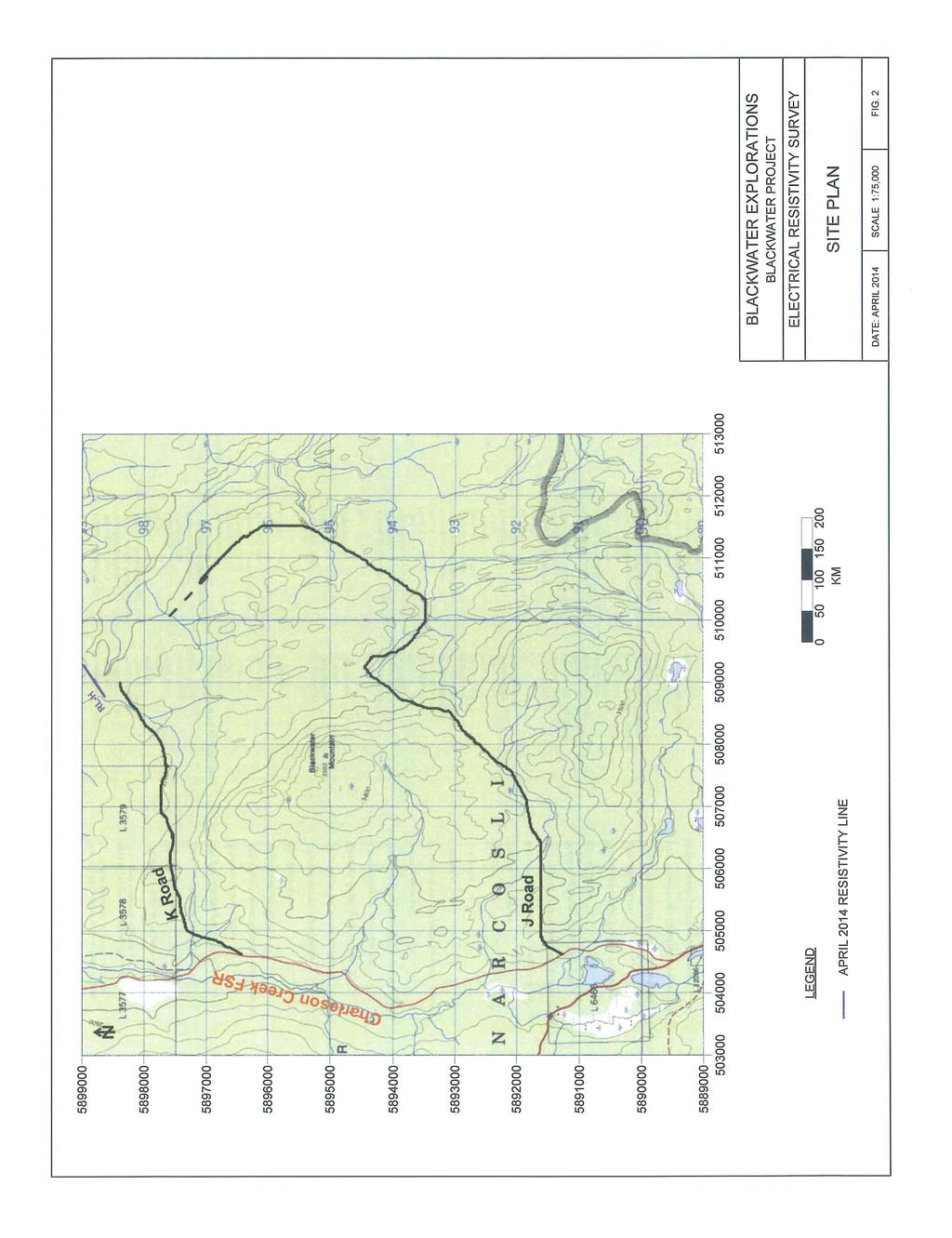
15 (i) CONTENTS 1. INTRODUCTION page 1 2. THE D.C. RESISTIVITY METHOD 2.1 Equipment 2.2 Survey Procedure 2.3 Data Reduction GEOPHYSICAL RESULTS 3.1 General 3.2 Discussion LIMITATIONS 5 TABLES Table 1 Field Resistivity Data location Page 6 ILLUSTRATIONS Figure 1 Figure 2 Figure 3 Survey Location Plan Site Plan Resistivity Traverse RL-H location Page 2 Appendix Appendix
16 1 1. INTRODUCTION In the period April 12 to April 21, 2014, a D.C. resistivity profiling survey was carried out on behalf of Blackwater Explorations Ltd. on claim in the Cariboo Mining District. The purpose of the investigation was to expand on previous surveying* and provide further evidence of a postulated paleo-channel on the property. A Survey Location Plan of the area is shown at a scale of 1:200,000 in Figure 1. Direct current resistivity measurements of ground conditions were completed along a single 700 metre traverse that was situated parallel to and 150m north of, resistivity line RL-C. A Site Plan illustrating the locations of previous and current resistivity traverses is shown at a scale of 1:50,000 in Figure 2, in the Appendix. Apparent resistivity measurements were recorded at 12 locations with the spacing between readings maintained at 50m intervals. Recorded resistance readings were converted to apparent resistivity for each 50m station along the traverse. * Blackwater Explorations Ltd., Resistivity Profiling Survey, Placer Gold Exploration, Quesnel, B.C., September, Russell A. Hillman, P.Eng. Project BLK-570/2 * Blackwater Explorations Ltd., Resistivity Profiling Survey, Placer Gold Exploration, Quesnel, B.C., April, Russell A. Hillman, P.Eng. Project Blk-570/3 * Blackwater Explorations Ltd., Resistivity Profiling Survey, Placer Gold Exploration, Quesnel, B.C., August, Russell A. Hillman, P.Eng. Project Blk-570/4

17 N SURVEY AREA N N N N N N N E E E E E E E KILOMETRES BLACKWATER EXPLORATIONS BLACKWATER PROJECT ELECTRICAL RESISTIVITY SURVEY SURVEY LOCATION PLAN DATE: APRIL 2014 SCALE 1:200,000 FIG. 1
18 3 2. THE D.C. RESISTIVITY METHOD 2.1 Equipment The D.C. resistivity survey was carried out using an ABEM SAS-300B electrical resistivity system, with the associated interconnect cables and stainless steel electrodes. The purpose of the electrical surveying was to determine the subsurface resistivity distribution by recording measurements on the ground surface. The ground resistivity is related to various geological parameters such as the clay mineral and fluid content, porosity, and degree of water saturation in overburden layering and the underlying bedrock. Wenner soundings were obtained by applying a direct current or very low frequency synchronous alternating current to the ground through a pair of electrodes and measuring the resulting potential established by this current across a second set of electrodes. Electrical noise originating from industrial currents or natural earth currents are significantly reduced by the use of synchronous detection incorporated in the design of the SAS-300B, in which the transmitter current and receiver polarity are reversed periodically at a frequency of less than one Hertz. Noise, which is asynchronous with the switching frequency, is then averaged out. 2.2 Survey Procedure Field procedure consisted of driving 4 stainless steel metal electrodes into the shallow subsurface at intervals of 50 metres along the ground surface. Electrical current was then applied to the exterior two electrodes with the resulting potential in volts, recorded by the interior pair of electrodes. In the Wenner array, the spacing between the four in-line electrodes is the same. In this investigation, the a spacing between the electrodes was maintained at 50 metres. Resistance readings were recorded over several cycles of the measuring circuit, until a stable, constant value was confirmed for the reading. 2.3 Data Reduction Standard geometric factors exist for common electrode arrays such as Wenner, Schlumberger and Dipole-Dipole. In the Wenner array, the geometric factor is 2 a, where a is the electrode spacing. In this survey, the electrode spacing was maintained at 50 metres. In order to obtain resistivity values at each location, the geometric factor was multiplied by the recorded resistance reading in ohms.
19 4 3. GEOPHYSICAL RESULTS 3.1 General The results of the 700m long traverse of resistivity line RL-H is illustrated at 1:1000 horizontal and 1:5000 vertical scales in Figure 3 in the Appendix. The data for the twelve resistivity readings recorded along the line are listed in Table 1, on page Discussion The results of resistivity line RL-H indicate a central, high resistivity zone bounded to the southwest and northeast by two, broad, lower resistivity zones. The narrower and less pronounced resistivity low is centred on station H3, with a resistivity value of 97,389 ohm-m. To either side of this station, the resistivities moderately increase to values of the order of 121,000 ohm-m. This limited resistivity low may be due to a moderate thickening of lower resistivity, overburden layering at or near, station H3. This area of moderate resistivities is bounded to the northwest by higher resistivities of 149,225 ohm-m and 146,398 ohm-m at stations H6 and H7. These higher resistivities in the middle of the traverse may indicate the presence of shallower bedrock at this location. The northwest end of line H indicates a broad resistivity low centred at station H10. The resistivity value at station H10 of 84,195 ohm-m may indicate an area of deeper overburden and greater potential for a buried channel at that location. The new grouping of resistivity lines RL-G, RL-D, RL-C and RL-H have broad consistencies with generally higher resistivities to the southwest and lower resistivities to the northeast. The lower resistivities to the northeast are believed to be indicative of progressively deeper bedrock. With the exception of line RL-C which was limited in extent, lines RL-G, RL-D and RL-H all indicate a broad zone of lower resistivities along the northeastern half of the lines. Line RL-C also showed a decrease in resistivities to the northeast of station C4. This consistent pattern of resistivity lows indicates the most probable location for a buried channel is along the northeast half of the grouping of resistivity traverses RL-G, RL-D, RL-C and RL-H.
20 5 4. LIMITATIONS D.C. resistivity surveys are successful providing adequate contrasts exist in the subsurface in electrical resistivity between distinct geological materials. Also affecting resistivity are the degree of saturation of materials and the porosity, the concentration of dissolved electrolytes, the temperature and the amount and composition of colloids. Conductors identified in resistivity surveying are diverse and depending on geological settings, may include mineralization, graphite, argillite, shear or fault zones, clay beds, marl, saturated materials, clay till, mineralised leachate and zones of salt water intrusion. Electrically resistive materials include but are not limited to, sand and gravel, dry soils, underground voids and competent bedrock. The highest resistivities are generally recorded in crystalline rock. With few exceptions, no unique resistivity value defines a specific geological material. Penetration depths may be affected by the presence of highly conductive surficial materials that may partially mask deeper geological layering. In addition, the resolution of the resistivity method decreases exponentially with depth. In this survey, penetration depths are estimated to be of the order of 40 metres. Given the diffuse nature of the method, resolution is inherently poorer at a depth greater than one wavelength. The survey results can also be influenced by electrode coupling, presence of noise and man-made infrastructure such as pipes, fences, power lines and buried metallic objects. The resistivity values measured with the ABEM Terrameter are accurate and repeatable. The electronically-isolated transmitter sends out well-defined, regulated signal currents. The receiver discriminates noise and measures voltages correlated with the transmitter signal current. Receiver measurements at discrete time intervals are recorded when eddy currents, IP and cable transients decay. The unique integrator and measurement strategy embodied in the Terrameter allows extraction of the signal from natural occurring telluric currents, electrochemical variations at the potential electrodes and power transmission lines. The information in this report is based upon geophysical measurements and field procedures. The data for each individual reading was combined to obtain apparent resistivity. No interpretations or analysis into layer depths, thicknesses and true resistivities was carried out on the data. The results are technical in nature and are considered to be a reasonably accurate presentation of existing apparent resistivities within the limitations of the D.C. Resistivity method. Russell Hillman, P.Eng.
21 6 Table 1 Field Resistivity Data Line RL-H Station No Resistance (ohms) Resistivity (ohm-m) 127, ,695 97, , , , , ,836 96,761 84, , ,434

22 RL-D EXT. RL-H RL-C RL-D RL-G F R A S E R R I V E R RL F RL E RL-A RL-B LEGEND APRIL 2014 RESISTIVITY LINE AUGUST 2013 RESISTIVITY LINE METRES BLACKWATER EXPLORATIONS BLACKWATER PROJECT ELECTRICAL RESISTIVITY SURVEY APRIL 2013 RESISTIVITY LINE SITE PLAN 2012 RESISTIVITY LINE DATE: APRIL 2014 SCALE 1:50,000 FIG. 2
23 SW NE H6 H H1 H RESISTIVITY (ohm-m) H2 H4 H5 H8 H H3 H METRES NE 20NE 40NE 60NE 80NE 100NE 120NE 140NE 160NE 180NE 200NE 220NE 240NE 260NE 280NE 300NE 320NE 340NE 360NE 380NE 400NE 420NE 440NE 460NE 480NE 500NE 520NE 540NE 560NE 580NE 600NE 620NE 640NE DISTANCE (metres) H10 BLACKWATER EXPLORATIONS BLACKWATER PROJECT ELECTRICAL RESISTIVITY SURVEY RESISTIVITY TRAVERSE RL-H (2014) DATE: APRIL 2014 VSCALE 1:5,000 HSCALE 1:1,000 FIG. 3
24
25
OWNER OPERATOR: BLACKWATER EXPLORATIONS LTD. REPORT ON RESISTIVITY PROFILING SURVEY PLACER GOLD EXPLORATION
 OWNER OPERATOR: BLACKWATER EXPLORATIONS LTD. REPORT ON RESISTIVITY PROFILING SURVEY PLACER GOLD EXPLORATION CARIBOO MINING DISTRICT NTS 93G CLAIM PC682023 Latitude 53 13 35.64 Longitude 122 49 40.65 by
MOUNT POLLEY MINING CORPORATION TECHNICAL REPORT ON MULTI-ELECTRODE RESISTIVITY AND SEISMIC REFRACTION SURVEYS MOUNT POLLEY TAILINGS DAM PROJECT
 MOUNT PLEY MINING CORPORATION TECHNICAL REPORT ON MULTI-ELECTRODE RESISTIVITY AND SEISMIC REFRACTION SURVEYS MOUNT PLEY TAILINGS DAM PROJECT LIKELY, B.C. by Claudia Krumbiegel, M.Sc. Cliff Candy, P.Geo.
OWNER OPERATOR: BLACKWATER EXPLORATIONS LTD. REPORT ON SEISMIC REFRACTION SURVEY PLACER GOLD EXPLORATION
 OWNER OPERATOR: BLACKWATER EXPLORATIONS LTD. REPORT ON SEISMIC REFRACTION SURVEY PLACER GOLD EXPLORATION CARIBOO MINING DISTRICT NTS 93G CLAIM PC682023 Latitude 53 13 35.64 Longitude 122 49 40.65 by Russell
BLACKWATER EXPLORATIONS LTD. REPORT ON RESISTIVITY PROFILING SURVEY PLACER GOLD EXPLORATION QUESNEL AREA, B.C. Russell A. Hillman, P.Eng.
 BLACKWATER EXPLORATIONS LTD. REPORT ON RESISTIVITY PROFILING SURVEY PLACER GOLD EXPLORATION QUESNEL AREA, B.C. by Russell A. Hillman, P.Eng. September, 2012 PROJECT BLK-570/2 (i) CONTENTS 1. INTRODUCTION
1. Resistivity of rocks
 RESISTIVITY 1) Resistivity of rocks 2) General principles of resistivity surveying 3) Field procedures, interpretation and examples 4) Summary and conclusions INDUCED POLARIZATION 1) General principles
Geophysics Course Introduction to DC Resistivity
 NORAD supported project in MRRD covering Capacity Building and Institutional Cooperation in the field of Hydrogeology for Faryab Province Afghanistan Geophysics Course Introduction to DC Resistivity By
Geoelectricity. ieso 2010
 Geoelectricity ieso 2010 1 RESISTIVITY SURVEY AT VENETO VILLA GRITTI AT THE TOWN OF TREVISO (VENETO REGION) The survey was carried out to verify the underground presence of the fondations of a rustic building.
Electrical Surveying (part A)
") Electrical Surveying (part A) Dr. Laurent Marescot Course given at the University of Fribourg (2009) Contact: laurent@tomoquest.com www.tomoquest.com 1 Introduction Electrical surveying Resistivity method
Electrical Surveying (part A) Dr. Laurent Marescot Course given at the University of Fribourg (2009) Contact: laurent@tomoquest.com www.tomoquest.com 1 Introduction Electrical surveying Resistivity method
Geophysics for Environmental and Geotechnical Applications
 Geophysics for Environmental and Geotechnical Applications Dr. Katherine Grote University of Wisconsin Eau Claire Why Use Geophysics? Improve the quality of site characterization (higher resolution and
A Case Study of High-Resolution Gravity and Wenner-Schlumberger Resistivity for Geotechnical Engineering: An Example from North Jordan
 Research Journal of Applied Sciences, Engineering and Technology 5(4): 1377-1382-, 2013 ISSN: 2040-7459; e-issn: 2040-7467 Maxwell Scientific Organization, 2013 Submitted: July 09, 2012 Accepted: August
GLE 594: An introduction to applied geophysics
 GLE 594: An introduction to applied geophysics Electrical Resistivity Methods Fall 2004 Earth Properties and Basic Theory Reading Today : 207-218 Next Lecture : 218-228 1 Introduction Link resistivity
ELECTRICAL RESISTIVITY TOMOGRAPHY
 NOTIO Association Clay Technological Centre C/ Río Cabriel s/n 45007 Toledo Tel.: 925 24 11 62 info@notio.es www.notio.es Page 1 / 7 SUMMARY 1. PHYSICAL FUNDAMENTALS OF THE... 3 1.1. ELECTRICAL BEHAVIOR
LIST OF FIGURES APPENDICES
 RESISTIVITY / INDUCED POLARIZATION SURVEY EL PORVENIR PROJECT MUNICIPALITY OF REMEDIOS, ANTIOQUIA, COLOMBIA LOGISTICS REPORT M-17427 APRIL 2017 TABLE OF CONTENTS Abstract... 1 1. The Mandate... 2 2. El
ELECTRICAL RESISTIVITY SURVEYS AT THE ANDERSON RESIDENCE SITE, PORT CLYDE, ME. For: St.Germain-Collins
 ELECTRICAL RESISTIVITY SURVEYS AT THE ANDERSON RESIDENCE SITE, PORT CLYDE, ME For: St.Germain-Collins 4 Union Street, Suite 3 Bangor, Maine 441 July, 218 ELECTRICAL RESISTIVITY SURVEYS AT THE ANDERSON
FINAL REPORT GEOPHYSICAL INVESTIGATION VILLAGE ALHAMBRA RETENTION POND SITE THE VILLAGES, FLORIDA
 FINAL REPORT GEOPHYSICAL INVESTIGATION VILLAGE ALHAMBRA RETENTION POND SITE THE VILLAGES, FLORIDA Prepared for Andreyev Engineering, Inc. Oxford, FL Prepared by GeoView, Inc. St. Petersburg, FL August
Geophysics Course Interpreting DC Resistivity Data
 NORAD supported project in MRRD covering Capacity Building and Institutional Cooperation in the field of Hydrogeology for Faryab Province Afghanistan Geophysics Course Interpreting DC Resistivity Data
Lima Project: Seismic Refraction and Resistivity Survey. Alten du Plessis Global Geophysical
 Lima Project: Seismic Refraction and Resistivity Survey Alten du Plessis Global Geophysical Report no 0706/2006 18 December 2006 Lima Project: Seismic Refraction and Resistivity Survey by Alten du Plessis
POTASH DRAGON CHILE GEOPHYSICAL SURVEY TRANSIENT ELECTROMAGNETIC (TEM) METHOD. LLAMARA and SOLIDA PROJECTS SALAR DE LLAMARA, IQUIQUE, REGION I, CHILE
 METHOD. LLAMARA and SOLIDA PROJECTS SALAR DE LLAMARA, IQUIQUE, REGION I, CHILE") POTASH DRAGON CHILE GEOPHYSICAL SURVEY TRANSIENT ELECTROMAGNETIC (TEM) METHOD LLAMARA and SOLIDA PROJECTS SALAR DE LLAMARA, IQUIQUE, REGION I, CHILE OCTOBER 2012 CONTENT Page I INTRODUCTION 1 II FIELD
POTASH DRAGON CHILE GEOPHYSICAL SURVEY TRANSIENT ELECTROMAGNETIC (TEM) METHOD LLAMARA and SOLIDA PROJECTS SALAR DE LLAMARA, IQUIQUE, REGION I, CHILE OCTOBER 2012 CONTENT Page I INTRODUCTION 1 II FIELD
APPENDIX C Frontier Geoscience Geophysical Survey Report
 Aquifer Mapping Study WL09-1578 Town of Gibsons, British Columbia 13 May 2013 Submitted To The Town of Gibsons APPENDIX C Frontier Geoscience Geophysical Survey Report WATERLINE RESOURCES INC. REPORT ON
High Resolution Geophysics: A Better View of the Subsurface. By John Jansen, P.G., Ph.D., Aquifer Science and Technology
 High Resolution Geophysics: A Better View of the Subsurface By John Jansen, P.G., Ph.D., Aquifer Science and Technology Geologist Use Only Part of the Information Available To Them Most Geologist rely
Geophysics of Exploration for Water. Geoelectric methods III. edited by Peter Vass
 Geophysics of Exploration for Water Geoelectric methods III edited by Peter Vass The phenomenon of induced polarization was already noticed at the early stage of applying direct current electrical methods
KARST MAPPING WITH GEOPHYSICS AT MYSTERY CAVE STATE PARK, MINNESOTA
 KARST MAPPING WITH GEOPHYSICS AT MYSTERY CAVE STATE PARK, MINNESOTA By Todd A. Petersen and James A. Berg Geophysics Program Ground Water and Climatology Section DNR Waters June 2001 1.0 Summary A new
Geophysical Investigation: A Case Study of Basement Complex, Nigeria
 Geophysical Investigation: A Case Study of Basement Complex, Nigeria Adiela U.P 1, Ayodele Moses Oyewole 2 and Omoirabor Omoleomo 3 1 Department of Petroleum Engineering, Nigerian Agip Oil Company, Port
'?a October 31, 1990 COMINCO LTD. EXPLORATION NTS: 93 G-6. Cariboo Mining Division. Latitude: 53 deg. 16' N Longitude: 123 deg.
 COMINCO LTD. EXPLORATION NTS: 93 G-6 WESTERN DISTR CT Cariboo Mining Division Latitude: 53 deg. 16' N Longitude: 123 deg. 13' W Work Dates: June 7-8, 1990 '?a October 31, 1990 D.J. Holcombe ....... A ASSESSMENT
Analysis of electrical resistivity data for the determination of aquifer depth at Sapele RD in Benin city
 Available online at www.pelagiaresearchlibrary.com Advances in Applied Science Research, 203, 4(6):268-276 ISSN: 0976-860 CODEN (USA): AASRFC Analysis of electrical resistivity data for the determination
Case Study: University of Connecticut (UConn) Landfill
 Landfill") Case Study: University of Connecticut (UConn) Landfill Problem Statement:» Locate disposal trenches» Identify geologic features and distinguish them from leachate and locate preferential pathways in fractured
Case Study: University of Connecticut (UConn) Landfill Problem Statement:» Locate disposal trenches» Identify geologic features and distinguish them from leachate and locate preferential pathways in fractured
Electrical prospecting involves detection of surface effects produced by electrical current flow in the ground.
 Electrical Surveys in Geophysics Electrical prospecting involves detection of surface effects produced by electrical current flow in the ground. Electrical resistivity method Induced polarization (IP)
Subsurface Characterization using Electrical Resistivity(Dipole-Dipole) method at Lagos State University (LASU) Foundation School, Badagry
 method at Lagos State University (LASU) Foundation School, Badagry") Available online at www.pelagiaresearchlibrary.com Advances in Applied Science Research, 2010, 1 (1): 174-181 Subsurface Characterization using Electrical Resistivity(Dipole-Dipole) method at Lagos State
Available online at www.pelagiaresearchlibrary.com Advances in Applied Science Research, 2010, 1 (1): 174-181 Subsurface Characterization using Electrical Resistivity(Dipole-Dipole) method at Lagos State
P Forsmark site investigation. Electric soundings supporting inversion of helicopterborne EM-data. Hans Thunehed, Timo Pitkänen GeoVista AB
 P-03-44 Forsmark site investigation Electric soundings supporting inversion of helicopterborne EM-data Hans Thunehed, Timo Pitkänen GeoVista AB January 2003 Svensk Kärnbränslehantering AB Swedish Nuclear
ELECTRICAL PROSPECTING METHODS
 Suez Canal University Faculty of Science Department of Geology ELECTRICAL PROSPECTING METHODS Prepared By El-Arabi Hendi Shendi Professor of applied & environmental Geophysics 2008 1 CONTENTS Definitions
Electrical Methods. Resistivity Surveying
 Electrical Methods Resistivity Surveying Geologic Resistivity 1101 Resistivity surveying investigates variations of electrical resistance, by causing an electrical current to flow through the subsurface
GEOPHYSICAL REPORT ON AN INDUCED POLAR.IZATION SURVEY
 GEOPHYSICAL REPORT ON AN INDUCED POLAR.IZATION SURVEY T & V Claim Groups some 12 miles Northwest of Babine Lake, B.C. Latitude 55' 26'N Longitude 126' 35'W AUTHOR: Glen E. White, Chief Geophysicist,a,
The Efficacy of Enhancing Horizontal Resolution (EHR) Technique in Shallow Subsurface Study Using 2D Resistivity Method at Bukit Bunuh
 Technique in Shallow Subsurface Study Using 2D Resistivity Method at Bukit Bunuh") 212 International Conference on Geological and Environmental Sciences IPCBEE vol.3 6(212) (212)IACSIT Press, Singapoore The Efficacy of Enhancing Horizontal Resolution (EHR) Technique in Shallow Subsurface
212 International Conference on Geological and Environmental Sciences IPCBEE vol.3 6(212) (212)IACSIT Press, Singapoore The Efficacy of Enhancing Horizontal Resolution (EHR) Technique in Shallow Subsurface
DEVELOPMENT REPORT. Lone I Mineral Claim Group. Wild Horse River Area Cranbrook, B.C.
 DEVELOPMENT REPORT Lone I Mineral Claim Group Wild Horse River Area Cranbrook, B.C. Fort Steele Mining District NTS 82G/12E 49 38 35 Latitude 115 38 00 Longitude LONE PEAK PLACER LTD. 514-13th Avenue South
The Use of Vertical Electrical Sounding (VES) for Subsurface Geophysical Investigation around Bomo Area, Kaduna State, Nigeria
 for Subsurface Geophysical Investigation around Bomo Area, Kaduna State, Nigeria") IOSR Journal of Engineering (IOSRJEN) e-issn: 2250-3021, p-issn: 2278-8719 Vol. 3, Issue 1 (Jan. 2013), V4 PP 10-15 The Use of Vertical Electrical Sounding (VES) for Subsurface Geophysical Investigation
IOSR Journal of Engineering (IOSRJEN) e-issn: 2250-3021, p-issn: 2278-8719 Vol. 3, Issue 1 (Jan. 2013), V4 PP 10-15 The Use of Vertical Electrical Sounding (VES) for Subsurface Geophysical Investigation
For personal use only
 22 April 2013 Drilling to commence at Majada, Copper-Gold Prospect, Chile. Red Gum Resources Limited (ASX: RGX, Red Gum or the Company ) is pleased to announce that drilling of its Majada Copper-Gold Prospect,
Geophysical Investigation of Foundation Condition of A Site in Ikere- Ekiti, Ekiti State, South-Western Nigeria
 Australian Journal of Basic and Applied Sciences, 5(9): 1852-1857, 2011 ISSN 1991-8178 Geophysical Investigation of Foundation Condition of A Site in Ikere- Ekiti, Ekiti State, South-Western Nigeria 1
Definition. Useful References
 Introduction to Geophysics Short Course Assignments http://www.mines.edu/fs_home/tboyd/gp311/modules/res/main.html Definition Resistivity Method - Observation of electric fields caused by current introduced
Relevance of 2D Electrical Imaging in Subsurface Mapping: Case Study of National Animal Production Research Institute (NAPRI), Zaria.
, Zaria.") Relevance of 2D Electrical Imaging in Subsurface Mapping: Case Study of National Animal Production Research Institute (NAPRI), Zaria. S.I. Fadele, Ph.D. (in view) 1* ; J. Adamu, M.Sc. 2 ; N.O. Patrick,
Relevance of 2D Electrical Imaging in Subsurface Mapping: Case Study of National Animal Production Research Institute (NAPRI), Zaria. S.I. Fadele, Ph.D. (in view) 1* ; J. Adamu, M.Sc. 2 ; N.O. Patrick,
2-D Resistivity Study: The Horizontal Resolution Improvement by Introducing the Enhancing Horizontal Resolution (EHR) Technique
 Technique") Open Journal of Geology, 213, 3, 1-6 doi:1.4236/ojg.213.32b1 Published Online April 213 (http://www.scirp.org/journal/ojg) 2-D Resistivity Study: The Horizontal Resolution Improvement by Introducing the
Open Journal of Geology, 213, 3, 1-6 doi:1.4236/ojg.213.32b1 Published Online April 213 (http://www.scirp.org/journal/ojg) 2-D Resistivity Study: The Horizontal Resolution Improvement by Introducing the
S.I. Fadele, M.Sc. 1 ; P.O. Sule, Ph.D. 1 ; and B.B.M. Dewu, Ph.D * ABSTRACT
 The Use of Vertical Electrical Sounding (VES) for Groundwater Exploration around Nigerian College of Aviation Technology (NCAT), Zaria, Kaduna State, Nigeria. S.I. Fadele, M.Sc. 1 ; P.O. Sule, Ph.D. 1
Case Study: Shallow Subsurface Geology Mapping Using 2-D Resistivity Imaging with EHR Technique
 Available online at www.sciencedirect.com APCBEE Procedia 5 (213 ) 134 14 ICESD 213: January 19-2, Dubai, UAE Case Study: Shallow Subsurface Geology Mapping Using 2-D Resistivity Imaging with EHR Technique
Soil Mechanics and Foundation Engineering, Vol. 53, No. 1, March, 2016 (Russian Original No. 1, January-February, 2016)
") Soil Mechanics and Foundation Engineering, Vol. 53, No. 1, March, 2016 (Russian Original No. 1, January-February, 2016) SLOPE MONITORING STUDY USING SOIL MECHANICS PROPERTIES AND 4-D ELECTRICAL RESISTIVITY
Soil Mechanics and Foundation Engineering, Vol. 53, No. 1, March, 2016 (Russian Original No. 1, January-February, 2016) SLOPE MONITORING STUDY USING SOIL MECHANICS PROPERTIES AND 4-D ELECTRICAL RESISTIVITY
Geology 228/378 Applied and Environmental Geophysics Lecture 6. DC resistivity Surveys
 Geology 228/378 Applied and Environmental Geophysics Lecture 6 DC resistivity Surveys Direct current (DC) Resistivity. Introduction 2. Current flow in the ground 3. Schlumberger, Wenner, dipole-dipole,
Azimuthal Resistivity to Characterize Fractures in a Glacial Till. Mark Boris, University of Saskatchewan Jim Merriam, University of Saskatchewan
 Azimuthal Resistivity to Characterize Fractures in a Glacial Till Mark Boris, University of Saskatchewan Jim Merriam, University of Saskatchewan Abstract Azimuthal resistivity was used to characterize
Geophysical Site Investigation (Seismic methods) Amit Prashant Indian Institute of Technology Gandhinagar
 Amit Prashant Indian Institute of Technology Gandhinagar") Geophysical Site Investigation (Seismic methods) Amit Prashant Indian Institute of Technology Gandhinagar Short Course on Geotechnical Aspects of Earthquake Engineering 04 08 March, 2013 Seismic Waves
Geophysical Site Investigation (Seismic methods) Amit Prashant Indian Institute of Technology Gandhinagar Short Course on Geotechnical Aspects of Earthquake Engineering 04 08 March, 2013 Seismic Waves
COMINCO LTD. HORIZONTAL LOOP EM AND MAGNETIC SURVEYS ON SHA. CLAIMS 1, 2, 7 and 8 NELSON AND FORT STEELE MINING DIVISIONS, B.C.
 COMINCO LTD. EXPLORATION WESTERN DISTRICT NTS: 82-F/1 HORIZONTAL LOOP EM AND MAGNETIC SURVEYS ON SHA CLAIMS 1, 2, 7 and 8 - ASSESSMENT REPORT - NELSON AND FORT STEELE MINING DIVISIONS, B.C. Latitude Longitude
Vertical electrical sounding (VES) for subsurface geophysical investigation in Kanigiri area, Prakasam district, Andhra Pradesh, India
 for subsurface geophysical investigation in Kanigiri area, Prakasam district, Andhra Pradesh, India") Available online at www.pelagiaresearchlibrary.com Advances in Applied Science Research, 2014, 5(5):82-86 ISSN: 0976-8610 CODEN (USA): AASRFC Vertical electrical sounding (VES) for subsurface geophysical
Available online at www.pelagiaresearchlibrary.com Advances in Applied Science Research, 2014, 5(5):82-86 ISSN: 0976-8610 CODEN (USA): AASRFC Vertical electrical sounding (VES) for subsurface geophysical
Geophysical Investigation of the Precambrian Marble Occurrence in Itobe Area, Central Nigeria
 British Journal of Applied Science & Technology 4(13): 1891-1904, 2014 SCIENCEDOMAIN international www.sciencedomain.org Geophysical Investigation of the Precambrian Marble Occurrence in Itobe Area, Central
DC Resistivity Investigation of Anisotropy and Lateral Effect using Azimuthal Offset Wenner Array. a case Study of the University of Calabar, Nigeria
 DC Resistivity Investigation of Anisotropy and Lateral Effect using Azimuthal Offset Wenner Array. a case Study of the University of Calabar, Nigeria George, A. Michael 1,Abong. A. Agwul 2* 1.Department
Hamed Aber 1 : Islamic Azad University, Science and Research branch, Tehran, Iran. Mir Sattar Meshin chi asl 2 :
 Present a Proper Pattern for Choose Best Electrode Array Based on Geological Structure Investigating in Geoelectrical Tomography, in order to Get the Highest Resolution Image of the Subsurface Hamed Aber
MEMORANDUM. Interpretation of Magnetic and Volterra-3DIP survey MC Claims
 11966 95A Avenue, Delta, BC V4C 3W2 Canada Tel +1 (604) 582-1100 www.sjgeophysics.com MEMORANDUM Date: September 13, 2017 From: To: SUBJECT: E. Trent Pezzot Bonanza Mining Corporation Interpretation of
EXTREMELY FAST IP USED TO DELINEATE BURIED LANDFILLS. Norman R. Carlson, Cris Mauldin Mayerle, and Kenneth L. Zonge
 EXTREMELY FAST IP USED TO DELINEATE BURIED LANDFILLS Norman R. Carlson, Cris Mauldin Mayerle, and Kenneth L. Zonge Zonge Engineering and Research Organization, Inc. 3322 East Fort Lowell Road Tucson, Arizona,
GEOPHYSICAL IMAGING TO ENHANCE ANALYSIS, DESIGN AND DRILLING OF LARGE-SCALE GEOTHERMAL SYSTEMS. Abstract
 GEOPHYSICAL IMAGING TO ENHANCE ANALYSIS, DESIGN AND DRILLING OF LARGE-SCALE GEOTHERMAL SYSTEMS John A. Mundell, Mundell & Associates, Inc., Indianapolis, Indiana Gabriel Hebert, Mundell & Associates, Inc.,
LECTURE 10. Module 3 : Field Tests in Rock 3.6 GEOPHYSICAL INVESTIGATION
 LECTURE 10 3.6 GEOPHYSICAL INVESTIGATION In geophysical methods of site investigation, the application of the principles of physics are used to the study of the ground. The soil/rock have different characteristics
CHAPTER 5 GEOPHYSICAL SURVEY. 5.1 Purpose of Survey
 CHAPTE 5 GEOPHYSICAL SUVEY 5.1 Purpose of Survey The objective of the Time Domain Electro- Magnetic (TDEM) survey was to define the electrical structure of the Stampriet Artesian Basin and relate this
Scholars Research Library
 Available online at www.scholarsresearchlibrary.com Scholars Research Library Archives of Physics Research, 2010, 1 (2):37-45 (http://scholarsresearchlibrary.com/archive.html) ISSN 0976-0970 2-D Resistivity
Ground Magnetic and Electrical Resistivity Mapping for Basement Structurs over Charnokitic Terrain in Ado-Ekiti Area, Southwestern Nigeria
 International Journal of Science and Technology Volume 3 No. 10, October, 2014 Ground Magnetic and Electrical Resistivity Mapping for Basement Structurs over Charnokitic Terrain in Ado-Ekiti Area, Southwestern
Received 12 February 2010 Accepted 25 March Abstract. Keywords: sounding resistivity, gem-bearing gravel layer, Wenner, Schlumberger
 One Dimensional Resistivity Sounding for Resolving Gem-bearing Gravel Layer: A Comparison of Schlumberger with Wenner Techniques at Bo Rai, Eastern Thailand Piyaphong Chenrai 1, Punya Charusiri 1* and
ambiguity in earth sciences IESO Geophysics Section Eddy hartantyo, Lab Geofisika FMIPA UGM
 ambiguity in earth sciences IESO Geophysics Section Eddy hartantyo, Lab Geofisika FMIPA UGM Pelatihan Tahap II IESO Teknik Geologi UGM Februari 2009 1 Introduction Photos from http://www.eegs.org/whatis/
Surface and borehole electrical resistivity tomography
 Surface and borehole electrical resistivity tomography Laurent Marescot laurent@tomoquest.com Introduction Surface electrical resistivity surveying is based on the principle that the distribution of electrical
Figure 1: Location of principal shallow conductors at Alpala (anomalies C0-C10; 5 Ohm/m surfaces, red) and shallow zones of electrical chargeability
 and shallow zones of electrical chargeability") Figure 1: Location of principal shallow conductors at Alpala (anomalies C0-C10; 5 Ohm/m surfaces, red) and shallow zones of electrical chargeability (85 msecs, yellow-green) shown on iso-surfaces of MVI
Figure 1: Location of principal shallow conductors at Alpala (anomalies C0-C10; 5 Ohm/m surfaces, red) and shallow zones of electrical chargeability (85 msecs, yellow-green) shown on iso-surfaces of MVI
ERDC/GSL TN-14-1 August 2014 Electromagnetic Induction Survey of the Mississippi River in Cleveland, Mississippi
 Electromagnetic Induction Survey of the Mississippi River in Cleveland, Mississippi By Joseph B. Dunbar and Maureen K. Corcoran PURPOSE: This study was conducted in support of Mississippi State University
SUMMl'l WlLS LIU. GEOPHYSICAL REPORT. W. CT. a~evenson Y I
 SUMMl'l WlLS LIU. GEOPHYSICAL REPORT W. CT. a~evenson Y3 qi@, 1970. I 2-90 9 CONTENTS - PAGE Introduction... 1 Property... 1 Location and Access... 1 Survey Specifications Survey Grid... 1 Induced Polarization
Geophysical Investigation of Ground Water Using Vertical Electrical Sounding and Seismic Refraction Methods
 International Journal of Petroleum and Petrochemical Engineering (IJPPE) Volume 2, Issue 1, 2016, PP 6-11 ISSN 2454-7980 (Online) www.arcjournals.org Geophysical Investigation of Ground Water Using Vertical
Geophysical Study of Limestone Attributes At Abudu Area of Edo State, Nigeria
 Journal of Emerging Trends in Engineering and Applied Sciences (JETEAS) 2 (5): 795-800 Scholarlink Research Institute Journals, 2011 (ISSN: 2141-7016) jeteas.scholarlinkresearch.org Journal of Emerging
DOWN-HOLE SEISMIC SURVEY AND VERTICAL ELECTRIC SOUNDINGS RABASKA PROJECT, LÉVIS, QUÉBEC. Presented to :
 DOWN-HOLE SEISMIC SURVEY AND VERTICAL ELECTRIC SOUNDINGS RABASKA PROJECT, LÉVIS, QUÉBEC Presented to : TERRATECH 455, René-Lévesque Blvd. West Montreal, Québec HZ 1Z3 Presented by : GEOPHYSICS GPR INTERNATIONAL
DC resistivity surveys
 DC resistivity surveys Introduction This resource provides conceptual and theoretical background about DC resistivity surveying. It does not go into interpretation or inversion of data, although a subsequent
Fox 2-Record No. 2524
 F HELICOPTER E.M. AND MAGNETOMETER SURVEY OVER THE FOX CLAIMS, OMINECA MINING DISTRICT BRITISH COLUMBIA ON BEHALF OF OWNER MR. MIKE BOYLE Claims: Fox l-record No. 2523 Fox 2-Record No. 2524 Location 126'
Groundwater Exploration In Parts Of Mangu- Halle North-Central Nigeria.
 International Journal of Scientific and Research Publications, Volume 7, Issue 10, October 2017 440 Groundwater Exploration In Parts Of Mangu- Halle North-Central Nigeria. I. Mamuda *, P.M. Akushai **
Groundwater Assessment in Apapa Coast-Line Area of Lagos Using Electrical Resistivity Method
 Journal of Emerging Trends in Engineering and Applied Sciences (JETEAS) 2 (4): 673-679 Scholarlink Research Institute Journals, 2011 (ISSN: 2141-7016) jeteas.scholarlinkresearch.org Groundwater Assessment
Integration of Seismic Refraction and 2D Electrical Resistivity in Locating Geological Contact
 Open Journal of Geology, 2013, 3, 7-12 doi:10.4236/ojg.2013.32b002 Published Online April 2013 (http://www.scirp.org/journal/ojg) Integration of Seismic Refraction and 2D Electrical Resistivity in Locating
2-D RESISTIVITY IMAGING SURVEY FOR WATER-SUPPLY TUBE WELLS IN A BASEMENT COMPLEX: A CASE STUDY OF OOU CAMPUS, AGO-IWOYE SW NIGERIA
 2-D RESISTIVITY IMAGING SURVEY FOR WATER-SUPPLY TUBE WELLS IN A BASEMENT COMPLEX: A CASE STUDY OF OOU CAMPUS, AGO-IWOYE SW NIGERIA 1 AYOLABI, Elijah Adebowale. 2 FOLORUNSO, Adetayo Femi. and 3 ARIYO, Stephen
International Journal of Basic and Applied Sciences Raibu et. al., Vol. 1 No. 2 ISSN: (A peer reviewed International Journal)
") (A peer reviewed International Journal) Determination of Aquifer Layer by the Application of Electrical Resistivity and Electromagnetic Method of Exploration at Ojoo Town Oyo State Southwestern Nigeria
(A peer reviewed International Journal) Determination of Aquifer Layer by the Application of Electrical Resistivity and Electromagnetic Method of Exploration at Ojoo Town Oyo State Southwestern Nigeria
MT Prospecting. Map Resistivity. Determine Formations. Determine Structure. Targeted Drilling
 MT Prospecting Map Resistivity Determine Formations Determine Structure Targeted Drilling Cross-sectional interpretation before and after an MT survey of a mineral exploration prospect containing volcanic
Applied Geophysics for Environmental Site Characterization and Remediation
 Applied Geophysics for Environmental Site Characterization and Remediation MSECA Webinar September 24, 2015 John Mundell, P.E., L.P.G. Ryan Brumbaugh, L.P.G. MUNDELL & ASSOCIATES, INC. Webinar Objective
Resistivity & IP methods
 International PhD Course in HYDROGEOPHYSICS Resistivity & IP methods Andrew Binley Lancaster University Overview We have demonstrated links between hydrological and geophysical properties and show the
2-D Resistivity Imaging in Taiping, Perak, Malaysia
 2-D Resistivity Imaging in Taiping, Perak, Malaysia A. I. Rosli *,1, M. A. Mohamed Zawawi 1, H. Juahir 2, N. Z. Karim 3 and N. F. Yusof 1 1 Department of Biological and Agricultural Engineering, Faculty
Geophysical technique applied to gemexploration in Chanthaburi, Eastern Thailand
 Australian Journal of Basic and Applied Sciences, 6(9): 459-464, 2012 ISSN 1991-8178 Geophysical technique applied to gemexploration in Chanthaburi, Eastern Thailand 1 Piyaphong Chenrai, 1 Punya Charusiri,
Taseko Prosperity Gold-Copper Project. Appendix 3-6-Q
 Taseko Prosperity Gold-Copper Project Appendix 3-6-Q KNIGHT & PIESOLD LTD. AND TASEKO MINES LIMITED REPORT ON SEISMIC REFRACTION AND REFLECTION INVESTIGATION PROSPERITY PROJECT, FISH LAKE AREA WILLIAMS
FIG. 1 TOPOLOGY MAP SHOWING THE SURVEY AREA.
 SCIENCE WORLD JOURNAL VOL 2 (NO3) 2007 FULL LENGTH RESEARCH ARTICLE A REGIONAL GEOELECTRIC INVESTIGATION FOR GROUNDWATER EXPLORATION IN MINNA AREA, NORTH WEST NIGERIA. MOHAMMED, L. N. 1, *ABOH, H. O. 2
4.6 DC resistivity and IP field systems, data processing and interpretation
 4.6 DC resistivity and P field systems, data processing and interpretation Electrode arrays Response of a layered earth The anisotropic half space Response of simple inhomogeneities Solutions for arbitrary
Electrical imaging techniques for hydrological and risk assessment studies
 Séminaire IPG le 9 mars 2006 Strasbourg Institute of Geophysics ETH Hoenggerberg CH-8093 Zurich Electrical imaging techniques for hydrological and risk assessment studies Laurent Marescot laurent@aug.ig.erdw.ethz.ch
Long section view of the Broken Hill orebody
 Southwest Long section view of the Broken Hill orebody Northeast Kate Godber Geoforce Pty Ltd, Brisbane Current follows the least path of resistance i.e. conductive mineralisation This is called current
TWO DIMENSIONAL ELECTRICAL IMAGING OF THE SUBSURFACE STRUCTURE OF BOMO DAM ZARIA, KADUNA STATE NORTH CENTRAL NIGERIA
 TWO DIMENSIONAL ELECTRICAL IMAGING OF THE SUBSURFACE STRUCTURE OF BOMO DAM ZARIA, KADUNA STATE NORTH CENTRAL NIGERIA Felix O. Ojo, Department of Geology, Ekiti State University, Ado-Ekiti, Nigeria. Oladimeji
ASSESSMENT REPORT TITLE PAGE AND SUMMARY
 ASSESSMENT REPORT TITLE PAGE AND SUMMARY TITLE OF REPORT: 2016 Prospecting Report Sphynx Claim TOTAL COST: $167.56 AUTHOR(S): Giacomo Grassi SIGNATURE(S): NOTICE OF WORK PERMIT NUMBER(S)/DATE(S): STATEMENT
REPORT OF GEOPHYSICAL SURVEY
 REPORT OF GEOPHYSICAL SURVEY KARST IMAGING STUDY CADIZ INDUSTRIAL PARK CADIZ, TRIGG COUNTY, KY MUNDELL PROJECT NO. M NOVEMBER, South Downey Avenue, Indianapolis, Indiana - Telephone --, Facsimile -- www.mundellassociates.com
Groundwater Sustainability at Wadi Al Bih Dam, Ras El Khaimah, United Arab Emirates (UAE) using Geophysical methods
 using Geophysical methods") Groundwater Sustainability at Wadi Al Bih Dam, Ras El Khaimah, United Arab Emirates (UAE) using Geophysical methods Ahmed Murad, Amir Gabr, Saber Mahmoud, Hasan Arman & Abdulla Al Dhuhoori Geology Department
Groundwater Sustainability at Wadi Al Bih Dam, Ras El Khaimah, United Arab Emirates (UAE) using Geophysical methods Ahmed Murad, Amir Gabr, Saber Mahmoud, Hasan Arman & Abdulla Al Dhuhoori Geology Department
Morenikeji P. Anjorin, B.Tech. 1 and Martins O. Olorunfemi, Ph.D. 2*
 A Short Note on Comparative Study of Schlumberger and Half Schlumberger Arrays in Vertical Electrical Sounding in a Basement Complex Terrain of Southwest Nigeria. Morenikeji P. Anjorin, B.Tech. 1 and Martins
DELINEATION OF FRESH-BRACKISH WATER AND BRACKISH-SALINE WATER INTERFACES USING VES SOUNDINGS IN SHANI, BORNO STATE, NIGERIA
 JOURNAL OF ENVIRONMENTAL HYDROLOGY The Electronic Journal of the International Association for Environmental Hydrology On the World Wide Web at http://www.hydroweb.com VOLUME 19 2011 DELINEATION OF FRESH-BRACKISH
C13^COMMONWEALTH OF AUSTRALIA
 tal C13^COMMONWEALTH OF AUSTRALIA DEPARTMENT OF NATIONAL DEVELOPMENT BUREAU OF MINERAL RESOURCES, GEOLOGY AND GEOPHYSICS 44 1 NE/41 RECORD No. 1963/22 l^' it Ril R y#11, 1 zz^g M^ P3 C3 rn 00 GEOPHYSICAL
3,^COMMONWEALTH OF AUSTRALIA DEPARTMENT OF NATIONAL DEVELOPMENT
 6b/n/ 3,^COMMONWEALTH OF AUSTRALIA DEPARTMENT OF NATIONAL DEVELOPMENT S.^BUREAU OF MINERAL RESOURCES, GEOLOGY AND GEOPHYSICS RECORD No. 1966/119 HODDLES CREEK GEOPHYSICAL SURVEY, VICTORIA 1965 by R.J.
t+o...&zz!. ASSESSMENT REPORT Department of Miner and Petroleum Resources MAP.,- INDUCED POLAKIZATION SURVEY OVER THE BROOKS PROSPECT
 5873 INDUCED POLAKIZATION SURVEY OVER THE BROOKS PROSPECT BROOKS PENINSULA AREA VANCOUVER ISLAND, B.C. NANAIMO AND ALBERNI MINING DIVISIONS BY Z. B. DOBORZYNSKI JANUARY, 1976 Department of Miner and Petroleum
P Forsmark site investigation. Ground penetrating radar and resistivity measurements for overburden investigations
 P-03-43 Forsmark site investigation Ground penetrating radar and resistivity measurements for overburden investigations Johan Nissen, Malå Geoscience AB April 2003 Svensk Kärnbränslehantering AB Swedish
CHARACTERIZATION OF SOIL PROFILE OF DHAKA CITY USING ELECTRICAL RESISTIVITY TOMOGRAPHY (ERT)
") CHARACTERIZATION OF SOIL PROFILE OF DHAKA CITY USING ELECTRICAL RESISTIVITY TOMOGRAPHY (ERT) Mehedi Ahmed ANSARY 1, B.S. Pushpendue BISWAS 2 and Abul KHAIR 3 1 Professor, Department of Civil Engineering
CHARACTERIZATION OF SOIL PROFILE OF DHAKA CITY USING ELECTRICAL RESISTIVITY TOMOGRAPHY (ERT) Mehedi Ahmed ANSARY 1, B.S. Pushpendue BISWAS 2 and Abul KHAIR 3 1 Professor, Department of Civil Engineering
Geophysical Survey Interpretation Report
 116 Spadina Ave., Suite 400 Toronto, ON, M5V 2K6 Phone (416) 306 1941 Fax (416) 306 1949 Geophysical Survey Interpretation Report Quantec Titan-24 Distributed Acquisition System DC RESISTIVITY & INDUCED
ASSESSMENT REPORT I.P./RESISTIVITY AND MAGNETICS SURVEY ON THE HAUTETE PROPERTY LATITUDE: 55O 12' N LONGITUDE: 126O 07' W
 NTS: 93W1 ASSESSMENT REPORT I.P./RESISTIVITY AND MAGNETICS SURVEY ON THE HAUTETE PROPERTY LATITUDE: 55O 12' N LONGITUDE: 126O 07' W OMINECA MINING DISTRICI'. B.C. CLAIMS COVERED : TET 1-8 TIME PERIOD:
APPLICATION OF ELECTRICAL RESISTIVITY IMAGING TECHNIQUE IN THE STUDY OF SLOPE STABILITY IN BANDING ISLAND, PERAK
 313 APPLICATION OF ELECTRICAL RESISTIVITY IMAGING TECHNIQUE IN THE STUDY OF SLOPE STABILITY IN BANDING ISLAND, PERAK Siti Aishah Ismail*, Shaharin Ibrahim M.Sc (GS20247) 4 th Semester Introduction Landslides
FINAL REPORT GEOPHYSICAL INVESTIGATION WATER TOWER NO. 6 SITE PLANT CITY, FL
 APPENDIX B FINAL REPORT GEOPHYSICAL INVESTIGATION WATER TOWER NO. 6 SITE PLANT CITY, FL Prepared for Madrid Engineering Group, Inc. Bartow, FL Prepared by GeoView, Inc. St. Petersburg, FL February 28,
Application of Transient Electromagnetics for the Investigation of a Geothermal Site in Tanzania
 Application of Transient Electromagnetics for the Investigation of a Geothermal Site in Tanzania Gerlinde Schaumann, Federal Institute for Geosciences and Natural Resources (BGR), Stilleweg 2, 30655 Hannover,