P Forsmark site investigation. Ground penetrating radar and resistivity measurements for overburden investigations
|
|
|
- Patricia Day
- 5 years ago
- Views:
Transcription
1 P Forsmark site investigation Ground penetrating radar and resistivity measurements for overburden investigations Johan Nissen, Malå Geoscience AB April 2003 Svensk Kärnbränslehantering AB Swedish Nuclear Fuel and Waste Management Co Box 5864 SE Stockholm Sweden Tel Fax
2 ISSN SKB P Forsmark site investigation Ground penetrating radar and resistivity measurements for overburden investigations Johan Nissen, Malå Geoscience AB April 2003 Keywords: Ground penetrating radar, GPS, resistivity measurements, CVES, overburden investigations This report concerns a study which was conducted in part for SKB. The conclusions and viewpoints presented in the report are those of the author(s) and do not necessarily coincide with those of the client. A pdf version of this document can be downloaded from
3 Contents 1 Introduction 5 2 Objective and scope 7 3 Measuring procedure and equipment Resistivity measurements Positioning Radar measurements 11 4 Results and data delivery Resistivity measurements Profile 1 (LFM000568) Profiles 2, 3 and 4 (LFM000569, 570 and 571) Radar measurements Profile 1 (LFM000568) Profiles 2, 3, 4A and 7 (LFM000569, 570, 572 and 575) Profiles 5 and 6 (LFM and 574) Conclusions 25 5 References 27 Appendix 1 Coordinates along the survey profiles 29 3

4 1 Introduction This document reports data gained from ground penetrating radar (GPR) and resistivity (CVES) measurements in the Forsmark site investigation area (Figure 1-1). The first attempt to interpret the data obtained is also presented as well as an evaluation of the methods with respect to their applicability to overburden investigations. The project was carried out according to activity plan AP PF (SKB internal controlling document) Dyviksfjärden Asphällsfjärden Torget Bolundsfjärden Tixelfjärden Profile 6 Bruksdammen Profile1 Profile 5 Forsmark Fiskarfjärden Lotten Lövörsgräset Kallrigafjärden Profile 4 Profile 4A Profile 7 Kallrigafjärden Profile 2 Profile Legend Survey profiles (GPR and/or CVES) Candidate area Boundary of the area for bedrock mapping 0 0, km From GSD-Terrängkartan c Lantmäteriet Gävle 2001, Permission M2001/5268 Swedish Nuclear Fuel & Waste Management Co Figure 1-1. General overview of the Forsmark site investigation area. 5
5 2 Objective and scope The objective of the survey was to perform test measurements with two geophysical methods, which were considered to have a potential for future application to overburden investigations in the Forsmark area. The measurements were carried out during October 2002 January 2003 along eight profiles (Figure 1-1). Three profiles were investigated with both methods, one with CVES only and four with GPR only. 7
6 3 Measuring procedure and equipment The profiles measured have been denoted Profile 1 to Profile 7 and these denotations are consequently used in the raw data files. The corresponding SKB ID-codes are as follows: Profile 1 LFM (CVES, GPR(minor part)) 2 LFM (CVES, GPR) 3 LFM (CVES, GPR) 4 LFM (CVES) 4A LFM (GPR) 5 LFM (GPR) 6 LFM (GPR) 7 LFM (GPR) In this report, the field names (Profile 1 7) are used, frequently complemented by the SKB ID-codes. 3.1 Resistivity measurements Measurements with CVES (Continuous Vertical Electrical Sounding) were conducted with 5 m electrode separations along the Profiles 1 3 and with 2 m electrode separations along Profile 4 (Figure 1-1). The data was collected with the following equipment: Profile 1,2,3 ABEM Terrameter SAS 4000, S/N Cable system, 5 m Profile 4 ABEM Terrameter SAS 1000, S/N Cable system, 2 m For all readings, the equipment was set to perform a maximum of 4 stackings, with the condition that if the deviation between the first two readings was below 1% the stacking procedure was stopped. The error displayed is the deviation in percent between the two readings. If more than two stackings are performed, the resulting error is calculated as the standard deviation. Along all profiles, the data quality was good. In Figure 3-1, the error distribution for all 1809 readings from Profile 1 is demonstrated. As can be seen, the typical error is in the interval 0.1% 0.2%. 95% of all readings has a standard deviation less than 0.3%. 9
7 Error distribution (profile 1) % % Frequency Frequency 50% 25% % Error in % Figure 3-1. Distribution of error in CVES measurements, Profile Positioning A GPS reading was taken at each cable joint (i.e. for each 100 m in Profile 1 3 and each 40 m in Profile 4). The GPS instrument was checked on four local fix points in the area. Table 3-1 comprises the checks. It is seen that the deviation is within a few metres. Table 3-1. GPS readings at four local fix points, and the corresponding reference values from GEOCON /1/. ID Measured position GEOCON
8 3.3 Radar measurements All radar measurements were conducted with the Malå Geoscience RAMAC unshielded 50 MHz antennas and a CUII control unit. The data presented in this report is processed by means of the program REFLEXW, and the following processing steps were made: 1. Adjust time zero. 2. Remove DC shift. 3. Band pass filtering (Butterworth) MHz. 4. Gain adjustment for display. 11

9 4 Results and data delivery The obtained results from the investigation are presented below. The raw and processed/ interpreted data have been delivered on a CD to SKB. Information on the activity has been inserted in the SICADA database, whereas the delivered CD has been archived. It is foreseen that further interpretation, including input data from e.g. drilling, will be made in several steps. These future interpretations will be inserted in SICADA. The SICADA reference to the present activity is Field note Forsmark Resistivity measurements Profile 1 (LFM000568) Profile 1 was measured from east to west along the existing path of a seismic line, see Figure 4-1. At each cable joint (every 100 m) the position corresponding to the existing seismic line was noted. These positions are indicated in the interpretation. The positions of all cable joints are given in Appendix 1. The CVES-data (Figure 4-2 a,b) is presented after an inversion procedure with the program RES2DINV, version 3.4. Topography data from the seismic survey is included in the interpretation. Figure 4-1. Profile 1 (LFM000568). The yellow arrows show the route from the GPS readings. 13


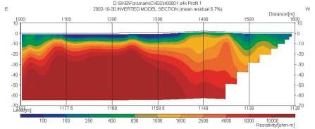
10 Figure 4-2a. Profile 1 (LFM000568). Resistivity sections. 14
: The resistivity of the overburden (soil) is in the range of 100 300 Ohm-m. The resistivity of the metagranitoid rock exceeds 10000 Ohm-m.")
11 Figure 4-2b. Profile 1 (LFM000568). Resistivity section (entire profile). Comments on the interpretation of Profile 1 (LFM000568): The resistivity of the overburden (soil) is in the range of Ohm-m. The resistivity of the metagranitoid rock exceeds Ohm-m. A transition zone with intermediate resistivity values in the upper part of the rock probably exists. However, the border between a low-resistive overburden and a high-resistive rock is difficult to resolve due to inherent limitations in the resistivity method. The overburden thickness is at most approximately 15 m. Between 190 m and 400 m (position 1268 to 1246) the granitoid rock is extending to the ground surface, with only a thin cover. The resistivity values at depth indicated intermediate rock quality. Between 460 m and 500 m (position 1240 to 1236) a possible fracture zone with low resistivity values manifest itself. The zone extends to at least 65 m depth. Between 500 m and 750 m (position 1236 to 1212) intermediate resistivity values in the range Ohm-m are observed. This is probably caused by water filled fractures. Between 750 m and 980 m (position 1212 to 1189) a wide zone with comparatively low resistivity values ( Ohm-m) is observed. This is probably caused by water filled fractures. The borders correspond to lineaments indicated on the geological map. Between 980 m and 1600 m (position 1189 to 1145) the rock resistivity is high, indicating rock of good quality. For all resistivity profiles a build-in bedrock edge detection algorithm (depth corresponding to a certain resistivity value /2/) is applied. In all cases, a resistivity value of 2000 Ohm-m for the detection of the bedrock surface has been used (Figure 4-3). However, this value has to be estimated by use of borehole data. If e.g. a value of 1500 Ohm-m is used, the result will be a shallower estimate of the bedrock surface. 15
12 Bedrock (2000 ohm-m), profile Bedrock (2000 ohm-m), profile Bedrock (2000 ohm-m), profile Figure 4-3. Detected bedrock along Profile 1 (LFM000568). The depth scale is corrected for topography. The line corresponds to a resistivity level of 2000 Ohm-m. 16
 starts at the intersection and follows the northern side of the road westwards. At position 500 m the border of the farmland is passed.")
13 4.1.2 Profiles 2, 3 and 4 (LFM000569, 570 and 571) The Profiles 2, 3 and 4 are located at Storskäret in the south-eastern part of the Forsmark area (Figures 1-1 and 4-4). Profile 2 (Figure 4-4) starts at the intersection and follows the northern side of the road westwards. At position 500 m the border of the farmland is passed. Profile 3 (Figure 4-4) starts at the intersection and follows the eastern side of the road southwards. Profile 4 (Figure 4-4) starts at the road and follows the power line southwards. This profile is measured with 2 m electrode separation, thereby giving a depth penetration down to approximately 25 metres as compared to the other profiles which are measured with 5 m separation, penetrating approximately 60 metres. The results are presented in Figures 4-5 to Profile 4A Profile 4 Profile 2 Profile 3 Figure 4-4. Location of the Profiles 2,3,4 and 4A (LFM ) at Storskäret. 17
. The depth scale is corrected for topography. The line corresponds to a resistivity level of 2000 Ohm-m.")
14 Figure 4-5. Profile 2 (LFM000569). Resistivity section. Bedrock (2000 ohm-m), profile Figure 4-6. Detected bedrock in Profile 2 (LFM000569). The depth scale is corrected for topography. The line corresponds to a resistivity level of 2000 Ohm-m. Comments on the interpretation of Profile 2 (LFM000569): The overburden thickness varies from 2 3 m (at position 130 m) to at least 20 m (at position 350 m). Between 310 m and 450 m a low-resistivity zone, probably a fracture zone, is observed. In general the rock resistivity values are high, indicating rock without fractures or fissures. 18
. The depth scale is corrected for topography. The line corresponds to a resistivity level of 2000 Ohm-m.")
15 Figure 4-7. Profile 3 (LFM000570). Resistivity section. Bedrock (2000 ohm-m), profile Figure 4-8. Detected bedrock in Profile 3 (LFM000570). The depth scale is corrected for topography. The line corresponds to a resistivity level of 2000 Ohm-m. Comments on the interpretation of Profile 3 (LFM000570): An area of low resistivity is observed between 150 m and 250 m. This may indicate a section of fractured bedrock. However, the profile is rather short for making definite conclusions. 19

16 Figure 4-9. Profile 4 (LFM000571). Resistivity section. Bedrock (2000 ohm-m), profile Figure Detected bedrock in Profile 4 (LFM000571). The depth scale is corrected for topography. The line corresponds to a resistivity level of 2000 Ohm-m. Comments on the interpretation of Profile 4 (LFM000571): A zone with low resistivity readings is observed from position 70 m to 120 m. This is probably a fracture zone. In general the overburden thickness is approximately m within the agricultural area. From 220 m to 320 m, the high resistivity readings indicate homogeneous rock of good quality. 20
.")
17 4.2 Radar measurements Profile 1 (LFM000568) In order to conduct radar measurements with the existing equipment, the survey lines need to be cleared from obstacles (spinney, thickets, etc). Due to the actual conditions along Profile 1, it was not possible to carry out measurements according to plan (i.e. along the entire profile). In Figure 4-11 a short section (130 m) of Profile 1 between position 1129 and 1139 (close to KFM01) is presented. The yellow arrows show the bedrock surface. Also a number of boulders on the bedrock surface can be observed. This example indicates that the radar method is suitable for detecting the bedrock surface Profiles 2, 3, 4A and 7 (LFM000569, 570, 572 and 575) For location of the Profiles 2, 3 and 4A, see Figure 4-4. Profile 4A was measured instead of Profile 4 in order to avoid disturbances from the power line along the latter profile. Profile 2 (Figures 4-12 and 4-13) is typical for all measured profiles in the Storskäret area. The penetration is very limited, only a few metres. This is due to conductive soil in the uppermost cm, probably caused by dust binding chemicals on the roads and/or fertilizers. Figures 4-14 and 4-15 show similar results from Profiles 3 and 4A. Repeated measurements of the above profiles were performed in January 2003 with identical results. At the same time, a new profile, Profile 7 (LFM000575, Figures 1-1 and 4-16), was measured at Storskäret along with additional measurements, Profiles 5 and 6, in the vicinity of borehole KFM01A (see section 4.2.3). Figure Part of Profile 1 (LFM000568). Yellow arrows indicate the bedrock surface. 21


18 Figure Radar data from Profile 2 (LFM000569). The hyperbolic signatures are caused by air reflections from trees and a building. Figure Enhanced view of a section of Profile 2 (LFM000569). The end of the agricultural area is at position 500 m. It is seen that there is essentially no penetration. The hyperbolic structures correspond to air-reflections from a fence and from trees. Figure Profile 3 (LFM000570). The hyperbolic signatures are caused by air reflections from trees, power lines and buildings. 22
 at Storskäret, from the barn along a new road to the entrance of the fence at KFM03. The gate is at position 46 m. 4.2.")

19 Figure Profile 4A (LFM000572) from fix point 1107 towards KFM03. The profile ends at a ditch. Figure Profile 7 (LFM000575) at Storskäret, from the barn along a new road to the entrance of the fence at KFM03. The gate is at position 46 m Profiles 5 and 6 (LFM and 574) Figure 4-17 shows the location of the Profiles 5 and 6, see also Figure 1-1. Figures 4-18 a c present the results from Profile 5 along the road, starting at the fence at KFM01, passing the road crossing at 62 m and extending southwards. The red line in the figures corresponds to the interpreted bedrock surface. Figure 4-19 presents the results from Profile 6 (LFM000574) measured along the road nearby KFM01. The profile starts at the power line, passes KFM01 and extends along a small road to SFM0003. It is seen that the filling material on the new road from KFM01 to SFM0003 screens the radar-wave. 23
 from KFM01.")


20 Figure The location of radar Profiles 5 and 6 (LFM000573, 574) Figure 4-18a. First 200 m of Profile 5 (LFM000573) from KFM01. Road crossing at 62 m. Fix point 1102 at position 206 m. The interpreted bedrock surface is indicated by a red line. Figure 4-18b. Profile 5(LFM000573) southwards along the road at KFM01. Fix point 1102 at position 206 m. The interpreted bedrock surface is indicated by a red line. 24
 along road, starting at power line, passing KFM01, extending along small road. Stop at SFM0003. Passing road intersection at 135 m and passing KFM01 at 195 m.")

21 Figure 4-18c. Last part of Profile 5 (LFM000573), ending at the turnaround at position 550 m. The interpreted bedrock surface is indicated by a red line. Figure Profile 6 (LFM000574) along road, starting at power line, passing KFM01, extending along small road. Stop at SFM0003. Passing road intersection at 135 m and passing KFM01 at 195 m. The interpreted bedrock surface is indicated by a red line. 4.3 Conclusions The present study has demonstrated that CVES measurements may give a good picture of the structure of the overburden and the upper part of the bedrock. It was also demonstrated that it is possible to achieve data of very good quality. An inherent disadvantage of the resistivity method is, however, its limited resolution of the depth to a resistive basement. According to the CVES measurements, the overall resistivity of the overburden is around 100 Ohm-m, which indicates that it should be possible to conduct successful radar measurements. This is also clearly demonstrated from the very short radar section of Profile 1 and from the profiles close to KFM01. The radar method is seen to be well suited mainly for mapping the overburden thickness. However, in the arable land around Storskäret many decades of farming have most probably created a zone of low resistivity near the surface, which makes radar measurements more or less impossible. Similarly, the use of dust-binding chemicals causes the conductivity to increase, thus making it difficult to perform radar measurements along the roads. 25
22 5 References /1/ GEOCON, Stomnätsmätning i plan och höjd vid PLU Forsmark. Rapport S1020. /2/ GEOTOMO Software, RES2DINV ver 3.51 Reference Manual. 27
23 Appendix 1 Coordinates along Profile 1 (LFM000568). The distance between each joint is 100 m. ID Easting Northing F F F F F F F F F F F F F F F F F Coordinates along Profile 2 (LFM000569). The distance between each joint is 100 m. ID Easting Northing F F F F F F F F
24 Coordinates along Profile 3 (LFM000570). The distance between each joint is 100 m. ID Easting Northing F F F F F Coordinates along Profile 4 (LFM000671). The distance between each joint is 40 m. ID Easting Northing F F F F F F F F F Coordinates along Profile 4A (LFM000672). ID Easting Northing F4A F4A Coordinates along Profile 5 (LFM000673). ID Easting Northing F F F F F F F F
25 Coordinates along Profile 6 (LFM000674). ID Easting Northing F F F F F F Coordinates along Profile 7 (LFM000675). ID Easting Northing F F F
P Forsmark site investigation. Electric soundings supporting inversion of helicopterborne EM-data. Hans Thunehed, Timo Pitkänen GeoVista AB
 P-03-44 Forsmark site investigation Electric soundings supporting inversion of helicopterborne EM-data Hans Thunehed, Timo Pitkänen GeoVista AB January 2003 Svensk Kärnbränslehantering AB Swedish Nuclear
P Forsmark site investigation. Borehole: KFM01A Results of tilt testing. Panayiotis Chryssanthakis Norwegian Geotechnical Institute, Oslo
 P-03-108 Forsmark site investigation Borehole: KFM01A Results of tilt testing Panayiotis Chryssanthakis Norwegian Geotechnical Institute, Oslo June 2003 Svensk Kärnbränslehantering AB Swedish Nuclear Fuel
P Swedish National Seismic Network (SNSN) A short report on recorded earthquakes during the second quarter of the year 2003
 A short report on recorded earthquakes during the second quarter of the year 2003") P-03-79 Swedish National Seismic Network (SNSN) A short report on recorded earthquakes during the second quarter of the year 2003 Reynir Böðvarsson Uppsala University, Department of Earth Sciences August
P-03-79 Swedish National Seismic Network (SNSN) A short report on recorded earthquakes during the second quarter of the year 2003 Reynir Böðvarsson Uppsala University, Department of Earth Sciences August
P Forsmark site investigation
 P-3-14 Forsmark site investigation A ground geophysical survey prior to the siting of borehole KFM5A and KFM6A and control of the character of two SW-NE oriented lineaments Timo Pitkänen, Hans Thunehed,
P Forsmark site investigation. Soil stratigraphy based on samples and protocols in the Forsmark area
 P-07-0 Forsmark site investigation Soil stratigraphy based on samples and protocols in the Forsmark area Joachim Albrecht, Sveriges Geologiska Undersökning January 007 Svensk Kärnbränslehantering AB Swedish
P Swedish National Seismic Network (SNSN) A short report on recorded earthquakes during the first quarter of the year 2003
 A short report on recorded earthquakes during the first quarter of the year 2003") P-03-37 Swedish National Seismic Network (SNSN) A short report on recorded earthquakes during the first quarter of the year 2003 Reynir Böðvarsson Uppsala University, Department of Earth Sciences May 2003
P-03-37 Swedish National Seismic Network (SNSN) A short report on recorded earthquakes during the first quarter of the year 2003 Reynir Böðvarsson Uppsala University, Department of Earth Sciences May 2003
P Oskarshamn site investigation. Refraction seismic measurements in Laxemar spring Gustaf Lindqvist, MRM Konsult AB.
 P-06-49 Oskarshamn site investigation Refraction seismic measurements in Laxemar spring 2006 Gustaf Lindqvist, MRM Konsult AB June 2006 Svensk Kärnbränslehantering AB Swedish Nuclear Fuel and Waste Management
P Oskarshamn site investigation. Boreholes KLX07A, KLX10, KLX05 and KLX12A
 P-07-63 Oskarshamn site investigation Boreholes KLX07A, KLX10, KLX05 and KLX12A Extensometer measurement of the coefficient of thermal expansion of rock Urban Åkesson SP, Technical Research Institute of
Lima Project: Seismic Refraction and Resistivity Survey. Alten du Plessis Global Geophysical
 Lima Project: Seismic Refraction and Resistivity Survey Alten du Plessis Global Geophysical Report no 0706/2006 18 December 2006 Lima Project: Seismic Refraction and Resistivity Survey by Alten du Plessis
P Oskarshamn site investigation. Borehole KLX04A Determination of P-wave velocity, transverse borehole core
 P-04-266 Oskarshamn site investigation Borehole KLX04A Determination of P-wave velocity, transverse borehole core Panayiotis Chryssanthakis, Lloyd Tunbridge Norwegian Geotechnical Institute October 2004
P Swedish National Seismic Network (SNSN) A short report on recorded earthquakes during the third quarter of the year 2006
 A short report on recorded earthquakes during the third quarter of the year 2006") P-06-235 Swedish National Seismic Network (SNSN) A short report on recorded earthquakes during the third quarter of the year 2006 Reynir Böðvarsson Uppsala University, Department of Earth Sciences October
P-06-235 Swedish National Seismic Network (SNSN) A short report on recorded earthquakes during the third quarter of the year 2006 Reynir Böðvarsson Uppsala University, Department of Earth Sciences October
B029 2D and 3D Resistivity Imaging in an Investigation of Boulder Occurrence and Soil Depth in Glacial Till
 B029 2D and 3D Resistivity Imaging in an Investigation of Boulder Occurrence and Soil Depth in Glacial Till R. Wisen* (Lund University), F. Linders (Lund University) & T. Dahlin (Lund University) SUMMARY
P Forsmark site investigation. Searching for evidence of late- or post-glacial faulting in the Forsmark region.
 P-03-76 Forsmark site investigation Searching for evidence of late- or post-glacial faulting in the Forsmark region Results from 2002 Robert Lagerbäck, Martin Sundh Geological Survey of Sweden (SGU) July
P Oskarshamn site investigation. Drill hole: KSH02. Extensometer measurement of the coefficient of thermal expansion of rock
 P-04-60 Oskarshamn site investigation Drill hole: KSH02 Extensometer measurement of the coefficient of thermal expansion of rock Urban Åkesson Swedish National Testing and Research Institute March 2004
KARST MAPPING WITH GEOPHYSICS AT MYSTERY CAVE STATE PARK, MINNESOTA
 KARST MAPPING WITH GEOPHYSICS AT MYSTERY CAVE STATE PARK, MINNESOTA By Todd A. Petersen and James A. Berg Geophysics Program Ground Water and Climatology Section DNR Waters June 2001 1.0 Summary A new
P Swedish National Seismic Network (SNSN) A short report on recorded earthquakes during the second quarter of the year 2007
 A short report on recorded earthquakes during the second quarter of the year 2007") P-07-163 Swedish National Seismic Network (SNSN) A short report on recorded earthquakes during the second quarter of the year 2007 Reynir Böðvarsson Uppsala University, Department of Earth Sciences July
P-07-163 Swedish National Seismic Network (SNSN) A short report on recorded earthquakes during the second quarter of the year 2007 Reynir Böðvarsson Uppsala University, Department of Earth Sciences July
Comparison of geophysical. techniques to determine depth to. bedrock in complex weathered. environments of the Mount Crawford. region, South Australia
 Comparison of geophysical techniques to determine depth to bedrock in complex weathered environments of the Mount Crawford region, South Australia Thesis submitted in accordance with the requirements of
Case Study: University of Connecticut (UConn) Landfill
 Landfill") Case Study: University of Connecticut (UConn) Landfill Problem Statement:» Locate disposal trenches» Identify geologic features and distinguish them from leachate and locate preferential pathways in fractured
Case Study: University of Connecticut (UConn) Landfill Problem Statement:» Locate disposal trenches» Identify geologic features and distinguish them from leachate and locate preferential pathways in fractured
P Oskarshamn site investigation. Refraction seismic measurements in the water outside Simpevarp and Ävrö and on land on Ävrö
 P-04-201 Oskarshamn site investigation Refraction seismic measurements in the water outside Simpevarp and Ävrö and on land on Ävrö Gustaf Lindqvist, MRM Konsult AB April 2004 Svensk Kärnbränslehantering
P Swedish National Seismic Network (SNSN) A short report on recorded earthquakes during the second quarter of the year 2011
 A short report on recorded earthquakes during the second quarter of the year 2011") P-11-35 Swedish National Seismic Network (SNSN) A short report on recorded earthquakes during the second quarter of the year 2011 Reynir Böðvarsson Uppsala University, Department of Earth Sciences July
P-11-35 Swedish National Seismic Network (SNSN) A short report on recorded earthquakes during the second quarter of the year 2011 Reynir Böðvarsson Uppsala University, Department of Earth Sciences July
GPR AS A COST EFFECTIVE BEDROCK MAPPING TOOL FOR LARGE AREAS. Abstract
 GPR AS A COST EFFECTIVE BEDROCK MAPPING TOOL FOR LARGE AREAS Dr. Jutta L. Hager, Hager GeoScience, Inc., Waltham, MA Mario Carnevale, Hager GeoScience, Inc., Waltham, MA Abstract Hager GeoScience, Inc.
CONTENTS 1. INTRODUCTION. 2. THE D.C. RESISTIVITY METHOD 2.1 Equipment 2.2 Survey Procedure 2.3 Data Reduction
 (i) CONTENTS 1. INTRODUCTION page 1 2. THE D.C. RESISTIVITY METHOD 2.1 Equipment 2.2 Survey Procedure 2.3 Data Reduction 3 3 3 3 3. GEOPHYSICAL RESULTS 3.1 General 3.2 Discussion 4 4 4 4. LIMITATIONS 5
P Oskarshamn site investigation. Drillhole KSH01A. Extensometer measurement of the coefficient of thermal expansion of rock (SINTEF)
") P-05-59 Oskarshamn site investigation Drillhole KSH01A Extensometer measurement of the coefficient of thermal expansion of rock (SINTEF) Lisbeth Alnæs, SINTEF Civil and Environmental Engineering, Rock
P-05-59 Oskarshamn site investigation Drillhole KSH01A Extensometer measurement of the coefficient of thermal expansion of rock (SINTEF) Lisbeth Alnæs, SINTEF Civil and Environmental Engineering, Rock
Relevance of 2D Electrical Imaging in Subsurface Mapping: Case Study of National Animal Production Research Institute (NAPRI), Zaria.
, Zaria.") Relevance of 2D Electrical Imaging in Subsurface Mapping: Case Study of National Animal Production Research Institute (NAPRI), Zaria. S.I. Fadele, Ph.D. (in view) 1* ; J. Adamu, M.Sc. 2 ; N.O. Patrick,
Relevance of 2D Electrical Imaging in Subsurface Mapping: Case Study of National Animal Production Research Institute (NAPRI), Zaria. S.I. Fadele, Ph.D. (in view) 1* ; J. Adamu, M.Sc. 2 ; N.O. Patrick,
The Efficacy of Enhancing Horizontal Resolution (EHR) Technique in Shallow Subsurface Study Using 2D Resistivity Method at Bukit Bunuh
 Technique in Shallow Subsurface Study Using 2D Resistivity Method at Bukit Bunuh") 212 International Conference on Geological and Environmental Sciences IPCBEE vol.3 6(212) (212)IACSIT Press, Singapoore The Efficacy of Enhancing Horizontal Resolution (EHR) Technique in Shallow Subsurface
212 International Conference on Geological and Environmental Sciences IPCBEE vol.3 6(212) (212)IACSIT Press, Singapoore The Efficacy of Enhancing Horizontal Resolution (EHR) Technique in Shallow Subsurface
ELECTRICAL RESISTIVITY SURVEYS AT THE ANDERSON RESIDENCE SITE, PORT CLYDE, ME. For: St.Germain-Collins
 ELECTRICAL RESISTIVITY SURVEYS AT THE ANDERSON RESIDENCE SITE, PORT CLYDE, ME For: St.Germain-Collins 4 Union Street, Suite 3 Bangor, Maine 441 July, 218 ELECTRICAL RESISTIVITY SURVEYS AT THE ANDERSON
GEOPHYSICAL SITE CHARACTERIZATION IN SUPPORT OF HIGHWAY EXPANSION PROJECT
 GEOPHYSICAL SITE CHARACTERIZATION IN SUPPORT OF HIGHWAY EXPANSION PROJECT * Shane Hickman, * Todd Lippincott, * Steve Cardimona, * Neil Anderson, and + Tim Newton * The University of Missouri-Rolla Department
R Bedrock geology Forsmark Modelling stage 2.3
 R-08-64 Bedrock geology Forsmark Modelling stage 2.3 Implications for and verification of the deterministic geological models based on complementary data Michael B Stephens, Geological Survey of Sweden
P Swedish National Seismic Network (SNSN) A short report on recorded earthquakes during the third quarter of the year 2009
 A short report on recorded earthquakes during the third quarter of the year 2009") P-09-61 Swedish National Seismic Network (SNSN) A short report on recorded earthquakes during the third quarter of the year 2009 Reynir Böðvarsson Uppsala University, Department of Earth Sciences October
P-09-61 Swedish National Seismic Network (SNSN) A short report on recorded earthquakes during the third quarter of the year 2009 Reynir Böðvarsson Uppsala University, Department of Earth Sciences October
Geoelectrical and IP Imaging Used for Pre-investigation at a Tunnel Project. Danielsen, Berit Ensted; Arver, Henrik; Karlsson, T; Dahlin, Torleif
 Geoelectrical and IP Imaging Used for Pre-investigation at a Tunnel Project Danielsen, Berit Ensted; Arver, Henrik; Karlsson, T; Dahlin, Torleif 2008 Link to publication Citation for published version
ELECTRICAL RESISTIVITY SURVEY OF INTREPID POTASH INJECTION WELL SITE: EDDY COUNTY, NEW MEXICO
 NCKRI REPORT OF INVESTIGATION 3 ELECTRICAL RESISTIVITY SURVEY OF INTREPID POTASH INJECTION WELL SITE: EDDY COUNTY, NEW MEXICO www.nckri.org NATIONAL CAVE AND KARST RESEARCH INSTITUTE REPORT OF INVESTIGATION
P Oskarshamn site investigation. Drill hole KAV01
 P-04-55 Oskarshamn site investigation Drill hole KAV01 Thermal properties: heat conductivity and heat capacity determined using the TPS method and Mineralogical composition by modal analysis Bijan Adl-Zarrabi
P Forsmark site investigation. Detailed fracture mapping of the outcrops Klubbudden, AFM and Drill Site 4, AFM001097
 P-03-115 Forsmark site investigation Detailed fracture mapping of the outcrops Klubbudden, AFM001098 and Drill Site 4, AFM001097 Jan Hermanson, Lars Hansen, Jon Vestgård, Peter Leiner Golder Associates
Borehole radar measurements aid structure geological interpretations
 Ž. Journal of Applied Geophysics 43 2000 www.elsevier.nlrlocaterjappgeo Borehole radar measurements aid structure geological interpretations S. Wanstedt ), S. Carlsten, S. Tiren GEOSIGMA, Box 894, S-751
TR Technical Report. Modelling of temperature in deep boreholes and evaluation of geothermal heat flow at Forsmark and Laxemar
 Technical Report TR-9-14 Modelling of temperature in deep boreholes and evaluation of geothermal heat flow at Forsmark and Laxemar Jan Sundberg, Pär-Erik Back, Märta Ländell, Anders Sundberg GEO INNOVA
Ronin Placer Ground-penetrating Radar Survey Report
 Ronin Placer Ground-penetrating Radar Survey Report Tenures: 837095, 837097 Mining Division: Greenwood NTS Location: 082E/03 Geographic Center Coordinates: UTM Zone 11, E 345340, N 5438730 Claims Owner:
A GPR ASSESSMENT OF THE PREHISTORIC NAPLES CANAL NAPLES, FLORIDA ARCHAEOLOGICAL AND HISTORICAL CONSERVANCY, INC.
 A GPR ASSESSMENT OF THE PREHISTORIC NAPLES CANAL NAPLES, FLORIDA ARCHAEOLOGICAL AND HISTORICAL CONSERVANCY, INC. AHC TECNICAL REPORT NO. 1004 DECEMBER 2013 A GPR ASSESSMENT OF THE PREHISTORIC NAPLES CANAL
APPENDIX C GEOPHYSICAL REPORT
 APPENDIX C GEOPHYSICAL REPORT GEOPHYSICAL ENGINEERING SURVEY REPORT 700 E 241 st Street NOVA PROJECT NUMBER 15-0522 DATED January 27, 2015 PREPARED FOR: LANGAN Long Warf Maritime Center New Haven, CT 06511
Resistivity survey at Stora Uppåkra, Sweden
 Resistivity survey at Stora Uppåkra, Sweden Dahlin, Torleif Published in: Uppåkra - Centrum i analys och rapport 2001 Link to publication Citation for published version (APA): Dahlin, T. (2001). Resistivity
Ronin and Dayton Placer Ground-penetrating Radar Survey Report
 Ronin and Dayton Placer Ground-penetrating Radar Survey Report Tenures: 837095, 837097, 889865, 890187 Mining Division: Greenwood NTS Location: 082E/03 Geographic Center Coordinates: UTM Zone 11, E 345340,
DOWN-HOLE SEISMIC SURVEY AND VERTICAL ELECTRIC SOUNDINGS RABASKA PROJECT, LÉVIS, QUÉBEC. Presented to :
 DOWN-HOLE SEISMIC SURVEY AND VERTICAL ELECTRIC SOUNDINGS RABASKA PROJECT, LÉVIS, QUÉBEC Presented to : TERRATECH 455, René-Lévesque Blvd. West Montreal, Québec HZ 1Z3 Presented by : GEOPHYSICS GPR INTERNATIONAL
LIST OF FIGURES APPENDICES
 RESISTIVITY / INDUCED POLARIZATION SURVEY EL PORVENIR PROJECT MUNICIPALITY OF REMEDIOS, ANTIOQUIA, COLOMBIA LOGISTICS REPORT M-17427 APRIL 2017 TABLE OF CONTENTS Abstract... 1 1. The Mandate... 2 2. El
geophysical investigations to identify groundwater pathways at a small open-pit copper mine reclaimed by backfilling and sealing
 Aachen, Germany Mine Water Managing the Challenges IMWA 2011 geophysical investigations to identify groundwater pathways at a small open-pit copper mine reclaimed by backfilling and sealing Lucile Villain,
The Use of Vertical Electrical Sounding (VES) for Subsurface Geophysical Investigation around Bomo Area, Kaduna State, Nigeria
 for Subsurface Geophysical Investigation around Bomo Area, Kaduna State, Nigeria") IOSR Journal of Engineering (IOSRJEN) e-issn: 2250-3021, p-issn: 2278-8719 Vol. 3, Issue 1 (Jan. 2013), V4 PP 10-15 The Use of Vertical Electrical Sounding (VES) for Subsurface Geophysical Investigation
IOSR Journal of Engineering (IOSRJEN) e-issn: 2250-3021, p-issn: 2278-8719 Vol. 3, Issue 1 (Jan. 2013), V4 PP 10-15 The Use of Vertical Electrical Sounding (VES) for Subsurface Geophysical Investigation
GPR profiling and electrical resistivity tomography for buried cavity detection: a test site at the Abbaye de l'ouye (France)
") GPR profiling and electrical resistivity tomography for buried cavity detection: a test site at the Abbaye de l'ouye (France) Nerouz BOUBAKI, Albane SAINTENOY, Piotr TUCHOLKA IDES - UMR 8148 CNRS, Université
GPR profiling and electrical resistivity tomography for buried cavity detection: a test site at the Abbaye de l'ouye (France) Nerouz BOUBAKI, Albane SAINTENOY, Piotr TUCHOLKA IDES - UMR 8148 CNRS, Université
Detecting Buried Human Bodies Using Ground-Penetrating Radar
 Earth Science Research; Vol. 5, No. 2; 2016 ISSN 1927-0542 E-ISSN 1927-0550 Published by Canadian Center of Science and Education Detecting Buried Human Bodies Using Ground-Penetrating Radar Widodo 1,
P Forsmark site investigation. Data report from the laboratory investigations of the transport properties of the rock.
 P-06-186 Forsmark site investigation Data report from the laboratory investigations of the transport properties of the rock. Data delivery for data freeze Forsmark 2.2 Eva Gustavsson, Geosigma AB September
Andrew Lee BEng (Hons) CEng MIStructE FGS FPWS
 CEng MIStructE FGS FPWS") Jim Twaddle BSc (Hons) FGS Andrew Lee BEng (Hons) CEng MIStructE FGS FPWS 22 January 2010 ME50231/RE001 !! "# # $ " %! &' ( "# # $ ) # ' %! "# # $ # "# # $ * + # "# # $ "! # "# # $, # "# # $! -( +.!!/
Jim Twaddle BSc (Hons) FGS Andrew Lee BEng (Hons) CEng MIStructE FGS FPWS 22 January 2010 ME50231/RE001 !! "# # $ " %! &' ( "# # $ ) # ' %! "# # $ # "# # $ * + # "# # $ "! # "# # $, # "# # $! -( +.!!/
P Oskarshamn site investigation. Rock matrix permeability measurements on core samples from borehole KLX03
 P-07-204 Oskarshamn site investigation Rock matrix permeability measurements on core samples from borehole KLX03 Peter Vilks, Atomic Energy of Canada Ltd December 2007 Svensk Kärnbränslehantering AB Swedish
LOZAR RADAR INTRODUCTORY PRESENTATION COAL SURVEYING
 LOZAR RADAR INTRODUCTORY PRESENTATION COAL SURVEYING WWW.LOZARRADAR.COM ABOUT LOZAR RADAR Lozar Radar is a ground-scanning device, which verifies and investigates the presence of mineral resources and
P Oskarshamn site investigation. Borehole KLX12A. Determination of P-wave velocity, transverse borehole core
 P-06-70 Oskarshamn site investigation Borehole KLX12A Determination of P-wave velocity, transverse borehole core Panayiotis Chryssanthakis, Lloyd Tunbridge Norwegian Geotechnical Institute, Oslo October
Instructional Objectives
 GE 6477 DISCONTINUOUS ROCK 8. Fracture Detection Dr. Norbert H. Maerz Missouri University of Science and Technology (573) 341-6714 norbert@mst.edu Instructional Objectives 1. List the advantages and disadvantages
POTASH DRAGON CHILE GEOPHYSICAL SURVEY TRANSIENT ELECTROMAGNETIC (TEM) METHOD. LLAMARA and SOLIDA PROJECTS SALAR DE LLAMARA, IQUIQUE, REGION I, CHILE
 METHOD. LLAMARA and SOLIDA PROJECTS SALAR DE LLAMARA, IQUIQUE, REGION I, CHILE") POTASH DRAGON CHILE GEOPHYSICAL SURVEY TRANSIENT ELECTROMAGNETIC (TEM) METHOD LLAMARA and SOLIDA PROJECTS SALAR DE LLAMARA, IQUIQUE, REGION I, CHILE OCTOBER 2012 CONTENT Page I INTRODUCTION 1 II FIELD
POTASH DRAGON CHILE GEOPHYSICAL SURVEY TRANSIENT ELECTROMAGNETIC (TEM) METHOD LLAMARA and SOLIDA PROJECTS SALAR DE LLAMARA, IQUIQUE, REGION I, CHILE OCTOBER 2012 CONTENT Page I INTRODUCTION 1 II FIELD
Available online Journal of Scientific and Engineering Research, 2016, 3(2):1-7. Research Article
:1-7. Research Article") Available online www.jsaer.com, 2016, 3(2):1-7 Research Article ISSN: 2394-2630 CODEN(USA): JSERBR Assessment of the Reliability of Magnetic Method to Delineate Geologic Features in a Basement Complex:
Available online www.jsaer.com, 2016, 3(2):1-7 Research Article ISSN: 2394-2630 CODEN(USA): JSERBR Assessment of the Reliability of Magnetic Method to Delineate Geologic Features in a Basement Complex:
Vergo Placer Claims Ground-penetrating Radar Survey Report
 Vergo Placer Claims Ground-penetrating Radar Survey Report Tenures: 583789, 586819 Mining Division: Greenwood NTS Location: 082E/03 Geographic Center Coordinates: UTM Zone 11, E 346013, N 5440152 Claims
FINAL REPORT GEOPHYSICAL INVESTIGATION WATER TOWER NO. 6 SITE PLANT CITY, FL
 APPENDIX B FINAL REPORT GEOPHYSICAL INVESTIGATION WATER TOWER NO. 6 SITE PLANT CITY, FL Prepared for Madrid Engineering Group, Inc. Bartow, FL Prepared by GeoView, Inc. St. Petersburg, FL February 28,
Tu Olym 01 Quantitative Depth to Bedrock Extraction from AEM Data
 Tu Olym 01 Quantitative Depth to Bedrock Extraction from AEM Data H. Anschütz (NGI), C. Christensen (Queen's University) & A.A. Pfaffhuber* (NGI) SUMMARY A new road segment is being planned northeast of
Ground Penetration Radar Survey at Yallah s Lower Basin, St. Thomas May , and June
 Ground Penetration Radar Survey at Yallah s Lower Basin, St. Thomas May 28-29., and June 01.-03. 2004 Faisal Butt and Nils-Otto Kitterød University of the West Indies, Mona Campus, Kingston, June 2004
Ice Thickness and Subglacial Topography Studies by Ground Penetrating Radar during the XX Indian Antarctic Expedition
 Ice Thickness and Subglacial Topography Studies by Ground Penetrating Radar during the XX Indian Antarctic Expedition J.T. GERGAN and RENOJ J. THAYYEN Wadia Institute of Himalayan Geology, Dehradun, Uttaranchal
Investigation of shallow leakage zones in a small embankment dam using repeated resistivity measurements
 Investigation of shallow leakage zones in a small embankment dam using repeated resistivity measurements Pontus Sjödahl 1, Sam Johansson 2, Torleif Dahlin 3 Resistivity measurements were carried out in
Geotechnical / Geophysical Investigation
 FEATURES TerraDol provides innovative geotechnical and geophysical exploration for civil construction projects including highway, railroad, subway, tunnel, bridge, port, and underground storage projects.
Geoelectrical Monitoring for Mapping of Gas and Water Migration in Landfills
 Geoelectrical Monitoring for Mapping of Gas and Water Migration in Landfills TORLEIF DAHLIN 1, HÅKAN ROSQVIST 2, SARA JOHANSSON 3, CARL-HENRIK MÅNSSON 3, MATS SVENSSON 3, MAGNUS LINDSJÖ 3 and MENG HENG
Site characterization at the Groundwater Remediation Field Laboratory
 Site characterization at the Groundwater Remediation Field Laboratory WILLIAM P. C LEMENT, STEVE CARDIMONA, ANTHONY L. ENDRES, Boston College, Boston, Massachusetts KATHARINE KADINSKY-CADE, Phillips Laboratory,
Natural stone assessment with ground penetrating radar (GPR)
") Natural stone assessment with ground penetrating radar (GPR) The 15th Meeting of the Association of European Geological Societies 16 20 September 2007 Tallinn, Estonia Hannu Luodes 18.9.2007 1 Location
Natural stone assessment with ground penetrating radar (GPR) The 15th Meeting of the Association of European Geological Societies 16 20 September 2007 Tallinn, Estonia Hannu Luodes 18.9.2007 1 Location
Use of Geophysical Software for Interpretation of Ice-Penetrating Radar Data and Mapping of Polar Ice Sheets
 Use of Geophysical Software for Interpretation of Ice-Penetrating Radar Data and Mapping of Polar Ice Sheets Alex O. Martinez University of Kansas 2335 Irving Hill Road Lawrence, KS 66045-7612 http://cresis.ku.edu
Mise-a-la-Masse Measurements at Olkiluoto 2007 and 2008
 Working Report 28-3 Mise-a-la-Masse Measurements at Olkiluoto 27 and 28 Anna-Maria Tarvainen June 28 POSIVA OY Olkiluoto FI-2716 EURAJOKI, FINLAND Tel +358-2-8372 31 Working Report 28-3 Mise-a-la-Masse
MT Prospecting. Map Resistivity. Determine Formations. Determine Structure. Targeted Drilling
 MT Prospecting Map Resistivity Determine Formations Determine Structure Targeted Drilling Cross-sectional interpretation before and after an MT survey of a mineral exploration prospect containing volcanic
Seismoelectric Ground-flow DC-4500 Locator
 Seismoelectric Ground-flow DC-4500 Locator Introduction The seismoelectric survey is a new technology combined the electro kinetic potential method and geophysical technology. It is applied directly to
P Forsmark site investigation. Snow depth, ground frost and ice cover during the winter 2004/2005
 P-05-134 Forsmark site investigation Snow, ground frost and ice cover during the winter 2004/2005 Niklas Heneryd, Svensk Kärnbränslehantering AB June 2005 Svensk Kärnbränslehantering AB Swedish Nuclear
2-D RESISTIVITY IMAGING SURVEY FOR WATER-SUPPLY TUBE WELLS IN A BASEMENT COMPLEX: A CASE STUDY OF OOU CAMPUS, AGO-IWOYE SW NIGERIA
 2-D RESISTIVITY IMAGING SURVEY FOR WATER-SUPPLY TUBE WELLS IN A BASEMENT COMPLEX: A CASE STUDY OF OOU CAMPUS, AGO-IWOYE SW NIGERIA 1 AYOLABI, Elijah Adebowale. 2 FOLORUNSO, Adetayo Femi. and 3 ARIYO, Stephen
Geophysical Investigation of Ground Water Using Vertical Electrical Sounding and Seismic Refraction Methods
 International Journal of Petroleum and Petrochemical Engineering (IJPPE) Volume 2, Issue 1, 2016, PP 6-11 ISSN 2454-7980 (Online) www.arcjournals.org Geophysical Investigation of Ground Water Using Vertical
BUFFALO RIVER COALITION PO Box 101, Jasper, AR (870)
") BUFFALO RIVER COALITION PO Box 101, Jasper, AR 72641 (870) 446-5783 buffalowatershed@gmail.com Presentation before Arkansas Pollution Control and Ecology Commission, April 29, 2016 by Richard Mays on behalf
BUFFALO RIVER COALITION PO Box 101, Jasper, AR 72641 (870) 446-5783 buffalowatershed@gmail.com Presentation before Arkansas Pollution Control and Ecology Commission, April 29, 2016 by Richard Mays on behalf
MOUNT POLLEY MINING CORPORATION TECHNICAL REPORT ON MULTI-ELECTRODE RESISTIVITY AND SEISMIC REFRACTION SURVEYS MOUNT POLLEY TAILINGS DAM PROJECT
 MOUNT PLEY MINING CORPORATION TECHNICAL REPORT ON MULTI-ELECTRODE RESISTIVITY AND SEISMIC REFRACTION SURVEYS MOUNT PLEY TAILINGS DAM PROJECT LIKELY, B.C. by Claudia Krumbiegel, M.Sc. Cliff Candy, P.Geo.
Geophysics Course Introduction to DC Resistivity
 NORAD supported project in MRRD covering Capacity Building and Institutional Cooperation in the field of Hydrogeology for Faryab Province Afghanistan Geophysics Course Introduction to DC Resistivity By
Environmental Geophysics for Coastal Management
 Environmental for Coastal Management Paul Donaldson 1, Dr Douglas Bergersen 2, Dr Matthew Barnes 3, Conor Jones 3 Coast To Coast, Hobart April 2018 1 BMT Newcastle, Australia, 2 Acoustic Imaging, Cooroy,
Geotechnical Deskstudy for Proposed Windfarm NV NORDISK VINDKRAFT AB. Fjällberg. Östersund , rev Fjällberg
 NV NORDISK VINDKRAFT AB Östersund 23-06-2011, rev 06-07-2012 Geotechnical Deskstudy for Proposed Windfarm Date 23-06-2011, rev 06-07-2012 Project number 61811144691000 JONSSON EVA TAJANI KRISTINA TAJANI
Scholars Research Library. Geophysical investigation of effects of topographic complexities on groundwater potential in Ibusa, Delta State Nigeria
 Available online at www.scholarsresearchlibrary.com Scholars Research Library Archives of Physics Research, 010, 1 (3):6-71 (http://scholarsresearchlibrary.com/archive.html) ISSN 0976-0970 CODEN (USA):
SURVEYING FOR GOLD. Page 1 of 25
 SURVEYING FOR GOLD Page 1 of 25 Page 2 of 25 Contents Introduction to Lozar Radar... 4 The Ground Penetrating Radar (GPR) system and Methodology... 4 Lozar Radar Surveying for Gold... 7 How Lozar Radar
SEISMIC RADAR AND ELECTRICAL TECHNIQUES FOR WASTE DISPOSAL ASSESSMENT. M. Pipan, G. Dal Moro, E. Forte & M. Sugan
 SEISMIC RADAR AND ELECTRICAL TECHNIQUES FOR WASTE DISPOSAL ASSESSMENT M. Pipan, G. Dal Moro, E. Forte & M. Sugan Department of Geological, Environmental and Marine Sciences, University of Trieste Via Weiss,
GEOL4714 Final Exam Fall 2005, C. H. Jones instructor
 GEOL4714 Final Exam Fall 2005 p. 1 GEOL4714 Final Exam Fall 2005, C. H. Jones instructor Name: Student ID #: Feel free to use the back of the sheets for answers needing more space. (1) (10 pts) For each
OWNER OPERATOR: BLACKWATER EXPLORATIONS LTD. REPORT ON RESISTIVITY PROFILING SURVEY PLACER GOLD EXPLORATION
 OWNER OPERATOR: BLACKWATER EXPLORATIONS LTD. REPORT ON RESISTIVITY PROFILING SURVEY PLACER GOLD EXPLORATION CARIBOO MINING DISTRICT NTS 93G CLAIM PC682023 Latitude 53 13 35.64 Longitude 122 49 40.65 by
The Preliminary Study of Meteorite Impact Crater at Bukit Bunuh, Lenggong
 2012 International Conference on Geological and Environmental Sciences IPCBEE vol.3 6(2012) (2012)IACSIT Press, Singapoore The Preliminary Study of Meteorite Impact Crater at Bukit Bunuh, Lenggong A. H.
Integration of Seismic Refraction and 2D Electrical Resistivity in Locating Geological Contact
 Open Journal of Geology, 2013, 3, 7-12 doi:10.4236/ojg.2013.32b002 Published Online April 2013 (http://www.scirp.org/journal/ojg) Integration of Seismic Refraction and 2D Electrical Resistivity in Locating
INTEGRATED GEOPHYSICAL CHARACTERIZATION AT A CONTAMINATED SITE. Abstract
 INTEGRATED GEOPHYSICAL CHARACTERIZATION AT A CONTAMINATED SITE Mario Carnevale, Hager GeoScience, Inc., Woburn, MA Jutta Hager, Hager GeoScience, Inc., Woburn, MA Brian R. Jones, Hager GeoScience, Inc.,
DETERMINATION OF ICE THICKNESS AND VOLUME OF HURD GLACIER, HURD PENINSULA, LIVINGSTONE ISLAND, ANTARCTICA
 Universidad de Granada MASTER S DEGREE IN GEOPHYSICS AND METEOROLOGY MASTER S THESIS DETERMINATION OF ICE THICKNESS AND VOLUME OF HURD GLACIER, HURD PENINSULA, LIVINGSTONE ISLAND, ANTARCTICA ÁNGEL RENTERO
An integrated approach to Geotechnics and Geophysics on the Electrification Programme in Denmark
 NGM 2016 Reykjavik Proceedings of the 17 th Nordic Geotechnical Meeting Challenges in Nordic Geotechnic 25 th 28 th of May An integrated approach to Geotechnics and Geophysics on the Electrification Programme
LECTURE 10. Module 3 : Field Tests in Rock 3.6 GEOPHYSICAL INVESTIGATION
 LECTURE 10 3.6 GEOPHYSICAL INVESTIGATION In geophysical methods of site investigation, the application of the principles of physics are used to the study of the ground. The soil/rock have different characteristics
Application of geophysical results to designing bridge. over a large fault
 Application of geophysical results to designing bridge over a large fault Ho-Joon Chung 1, Jung-Ho Kim 2, Keun-Pil Park 2, Hyoung-Seok Kwon 1, Ho-Sik Choi 3, Ki-Seog Kim 4, Jong-Soo Kim 5 1 Manager, HeeSong
The Search for Ancient Helike: a GPR Case Study. Doria L. Kutrubes 1 Radar Solutions International. Steven Soter Smithsonian Institution
 The Search for Ancient Helike: a GPR Case Study Doria L. Kutrubes 1 Radar Solutions International Steven Soter Smithsonian Institution Dora Katsonopoulou American School of Classical Studies at Athens
P Forsmark site investigation. Quantitative mapping of fracture minerals in Forsmark. Stefan Eklund, Karl-Johan Mattsson Geosigma AB
 P-08-47 Forsmark site investigation Quantitative mapping of fracture minerals in Forsmark Stefan Eklund, Karl-Johan Mattsson Geosigma AB December 2009 Svensk Kärnbränslehantering AB Swedish Nuclear Fuel
Groundwater Assessment in Apapa Coast-Line Area of Lagos Using Electrical Resistivity Method
 Journal of Emerging Trends in Engineering and Applied Sciences (JETEAS) 2 (4): 673-679 Scholarlink Research Institute Journals, 2011 (ISSN: 2141-7016) jeteas.scholarlinkresearch.org Groundwater Assessment
Analysis of electrical resistivity data for the determination of aquifer depth at Sapele RD in Benin city
 Available online at www.pelagiaresearchlibrary.com Advances in Applied Science Research, 203, 4(6):268-276 ISSN: 0976-860 CODEN (USA): AASRFC Analysis of electrical resistivity data for the determination
General Editor: Vince Russett
 YCCCART 2014/Y20 North Somerset HER 2015/11 Manual survey using an electronic, hydryostatic level (NIVCOMP) at Wemberham Roman Villa YATTON, CONGRESBURY, CLAVERHAM AND CLEEVE ARCHAEOLOGICAL RESEARCH TEAM
SIXTH SCHEDULE REPUBLIC OF SOUTH SUDAN MINISTRY OF PETROLEUM, MINING THE MINING (MINERAL TITLE) REGULATIONS 2015
 REGULATIONS 2015") SIXTH SCHEDULE REPUBLIC OF SOUTH SUDAN MINISTRY OF PETROLEUM, MINING THE MINING ACT, 2012 THE MINING (MINERAL TITLE) REGULATIONS 2015 Guidelines should be prepared by the Directorate of Mineral Development
SIXTH SCHEDULE REPUBLIC OF SOUTH SUDAN MINISTRY OF PETROLEUM, MINING THE MINING ACT, 2012 THE MINING (MINERAL TITLE) REGULATIONS 2015 Guidelines should be prepared by the Directorate of Mineral Development
Initial Borehole Drilling in the Hornepayne and Manitouwadge Area
 MAY 2017 PRELIMINARY ASSESSMENT OF POTENTIAL SUITABILITY Initial Borehole Drilling in the Hornepayne and Manitouwadge Area In 2010, the Nuclear Waste Management Organization (NWMO) began technical and
We N Geophysical Near-surface Characterization for Static Corrections: Multi-physics Survey in Reggane Field, Algeria
 We N114 01 Geophysical Near-surface Characterization for Static Corrections: Multi-physics Survey in Reggane Field, Algeria A. Pineda* (Repsol), S. Gallo (CGG) & H. Harkas (GRN Sonatrach) SUMMARY We are
Geophysical Survey Report
 Report Lost Mansion of Nydfwch, Penllergare, Swansea for January 2008 J2449 John Cook BSc. (Hons) Document Title: Client: Stratascan Job No: Techniques: Report Lost Mansion of Nydfwch, Penllergare, Swansea
Hazard Mapping Along the Dead Sea Shoreline
 FIG Working Week in Marrakech, Morocco 18-22 May 2011 Hazard Mapping Along the Dead Sea Shoreline Rami Al-Ruzouq, Abdullah Al-Zuobi, AbdEl-Rahman Abueladas, Emad Akkawi Department of Surveying and Geomatics
Common Exploration Methods.
 Common Exploration Methods. The following list contains the most common methods which a company with a mineral prospecting licence in Northern Ireland might use to carry out a mineral prospecting programme.
A Survey of St Michael and All Angels Churchyard Hamstall Ridware
 Project No 6 A Survey of St Michael and All Angels Churchyard by M R Holland Annie Saunders MA March 2003 Table of Contents Introduction Methods Acknowledgements Appendix A Geophysics 3 3 5 6 Table of