Instructional Objectives
|
|
|
- Curtis Hoover
- 5 years ago
- Views:
Transcription
1 GE 6477 DISCONTINUOUS ROCK 8. Fracture Detection Dr. Norbert H. Maerz Missouri University of Science and Technology (573) Instructional Objectives 1. List the advantages and disadvantages of surface mapping of discontinuities. 2. List which characteristics of discontinuities can be obtained from oriented cores. Which cannot? 3. Compare optical, acoustic and electrical imaging of the inside of the borehole. 4. Explain the Terzaghi borehole bias and critique the methods of measuring fracture orientations in terms of that bias. 5. Discuss the effectiveness of the various surface geophysical methods in detecting discontinuities. 6. Determine what advantages there are in borehole tomography. 7. Give the advantages and disadvantages of conventional borehole logging. 1
2 Fracture Detection 7.1 Surface mapping 7.2 Borehole logging 7.3 Geophysical methods 7.4 Other methods Site Investigation 1. Primary 2. Secondary 3. Tertiary 2
3 Primary (research phase) Research of topographic and geological maps and reports Research of regional seismic and ground stress data Walking reconnaissance of the site and of regional outcrops, exposures of the rocks in nearby tunnels and mines Study of nearby water-well records Air photo study using existing photography Discussions with local residents and specialists Preparation of base maps Preliminary report on site conditions: plan next phase Secondary Phase Detailed logging of rock outcrop, statistics on jointing Exploratory test pits and trenches: sampling Index testing in situ and in the laboratory Reconnaissance by helicopter or light airplane Probe hole drilling using auger or air track Seismic or electromagnetic geophysical traverses Special air photography and supplementary interpretation Preliminary, limited core drilling, logging, and testing Definition of soil-rock interface topography Rock mass classification Progress report: plan next phase 3

4 Tertiary Phase Further core drilling, vertical, inclined, or horizontal Jointing information from drillhole television, impression packers, oriented core 1 integral-core sampling Downhole geophysical logging and tomography between holes to define rock mass quality and individual faults, etc. Downhole testing using a dilatometer to measure deformability Packer testing for hydraulic conductivity Installation of piezometers to study the groundwater regime and to monitor piezometric pressures In situ stress determinations Excavation and logging of exploratory trenches, adits, shafts Large-scale in situ strength and deformability tests Full evaluation of soil, rock, groundwater, and stress regimes Final site investigation report 8.1 Surface mapping 4
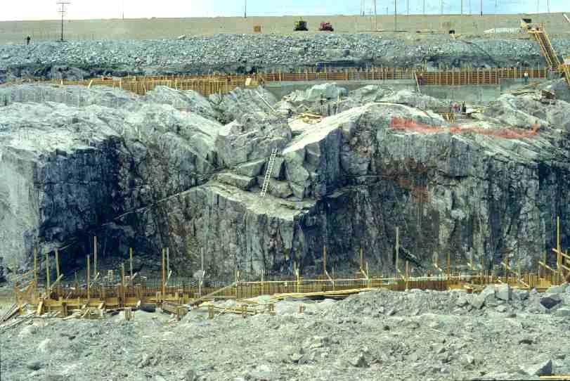
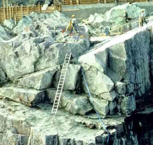
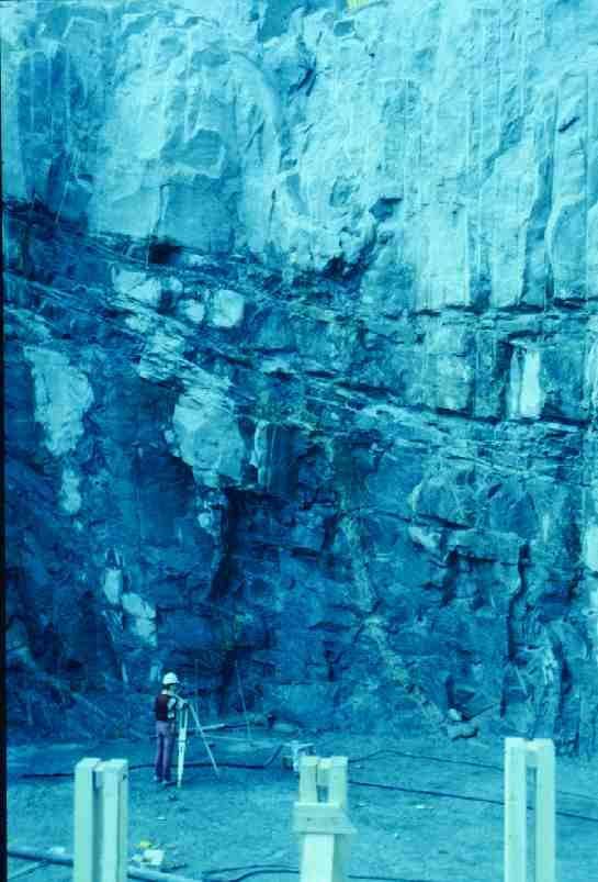
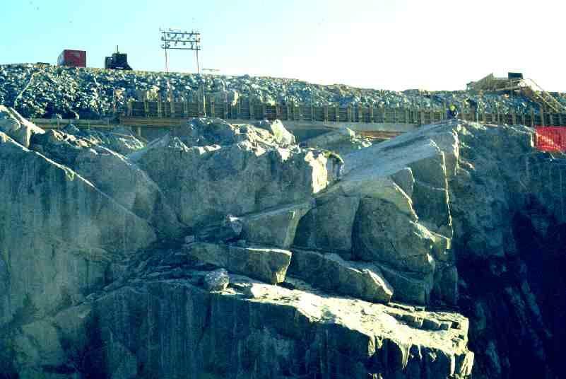
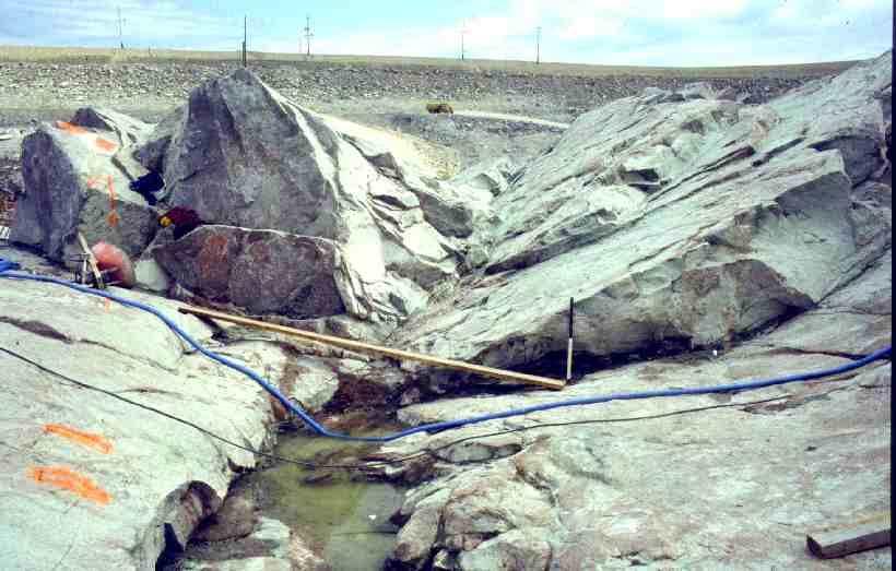
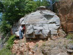
5 Surface mapping features Orientation Spacing Persistence Roughness Wall Strength Aperture Filling Seepage Number of Sets Block Size Surface mapping Advantages: Most comprehensive coverage: can see joints and pattern Least sampling bias Highest resolution Inexpensive for small natural exposures Disadvantages: Natural outcrops rarely in the best location Creating large exposures can be expensive Rock character can be different (weathered, more fractured) 5

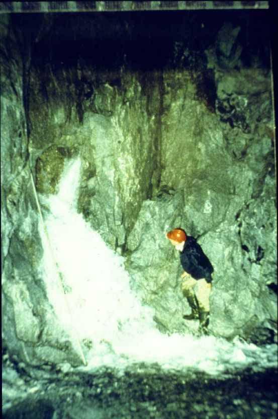
6 6

7 7
8 8
9 9
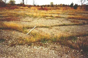
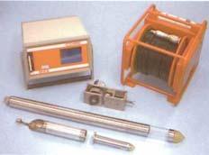
10 Extrapolating Satellite and Air Photography Convenience as a remote sensing tool Small scale only 2-D only 10


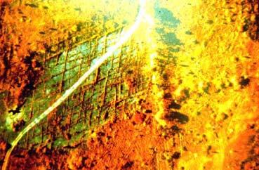
11 Under water lineaments False color infrared of vegetation patterns 11


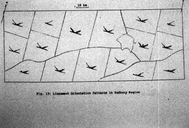
12 Summary Data Sudbury - Lineament Analysis 12


13 8.2 Borehole logging 13
14 14
15 Bore hole logging features Orientation Spacing Persistence Roughness Wall Strength Aperture Filling Seepage Number of Sets Block Size Bore hole logging Advantages: Drilling ubiquitous Pinpoint location Core can be preserved for later analysis Cost effective Natural sampling vehicle for lab tests Disadvantages: Less precise data Borehole orientation bias Small scale structures 15


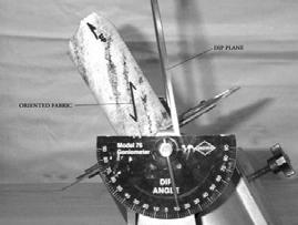
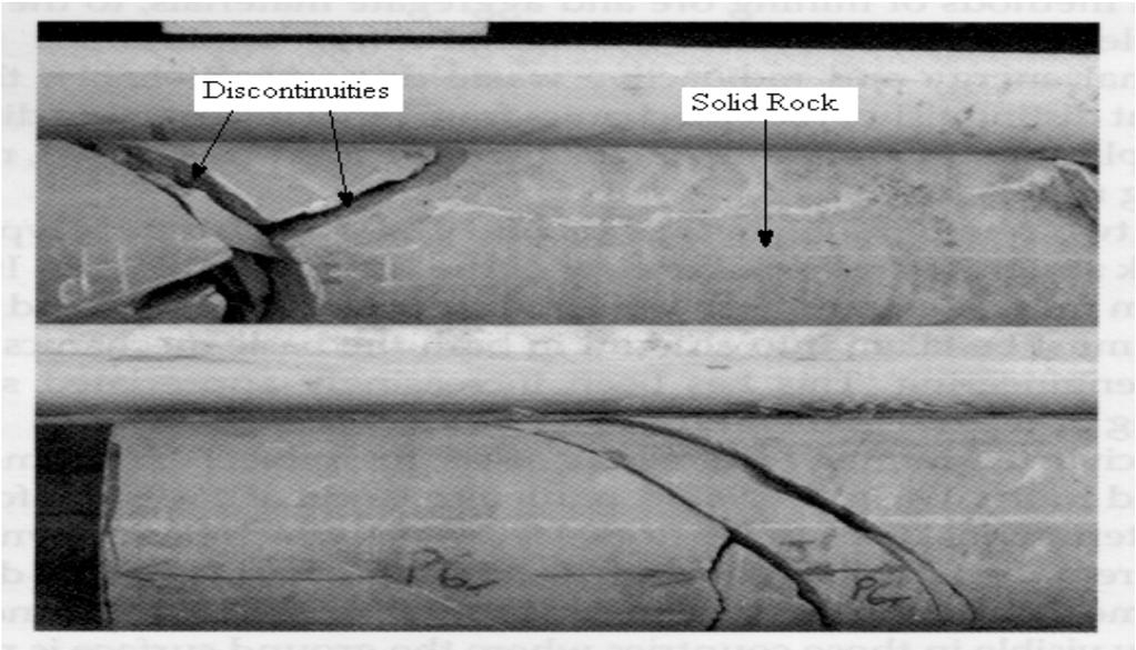
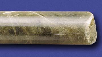
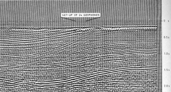
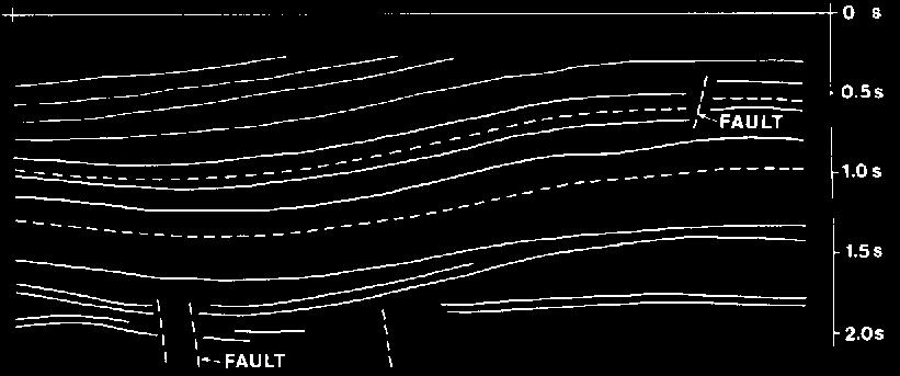
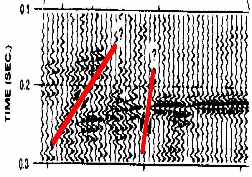
16 Oriented core Reorienting Core Using a Goniometer 16


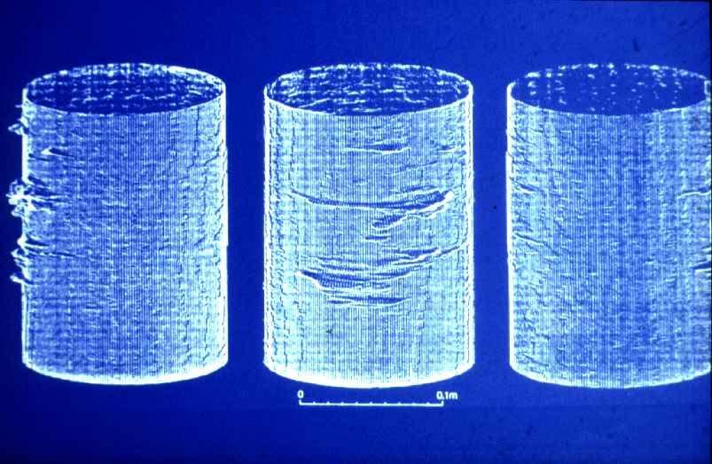
17 Bore hole optical imaging Bore hole acoustic imaging 17


18 Bore hole impression packer Electrical imaging FMS (Formation microscanner) image Electrodes on 4 individual electrode pads of a dipmeter 18
19 Terzaghi bore hole bias N Lsin d N (L/d=1) Terzaghi bore hole bias Values of sin for a borehole inclined at 45 degrees. Great circle blind zone 19
20 Terzaghi bore hole bias Mutually orthogonal boreholes, to eliminate borehole bias 8.3 Geophysical methods 1) Large scale (surface sounding) 2) Intermediate scale (surface to borehole, borehole to borehole) 3) Small scale (rock adjacent to free surface) 20
21 8.3 Geophysical Methods Seismic Ultrasonic Electrical Electromagnetic Radar Bore hole methods Geophysical methods Fractures are thin, thus are two dimensional anomalies Inverse relationship between depth of penetration and resolution Typical scenario: 1 equation, many unknowns Most methods highly dependent on deduction and interpretation 21
22 Geophysical methods 1) Get and reduce measurement data. 2) Invert data to get local rock properties. 3) Deduce fracture properties from rock property data. 4) Interpret fracture geometries using a model Seismic Properties Velocity Attenuation Reflection Refraction 22


23 Surface methods: Seismic refraction Surface methods: Seismic reflection 23
24 Seismic reflection Seismic reflection 24

25 3-D section Microsiemics 25
26 8.3.2 Ultrasonic Low penetration, used generally to determine microscopic fissuring Surface methods: Electrical and Electromagnetic Methods Water filled fractures have higher electrical conductivity in low porosity rock Difficult to identify individual fractures, unless independent evidence is found Best for identifying fractured zones, especially effective if fractures are filled with conductive fluids 26
27 Electrical methods - Relationship to hydraulic properties 27


28 8.3.5 Surface method: Ground penetrating radar Similar to reflection seismics in interpretation Different frequencies = different resolutions and penetration 28
29 29
30 8.3.6 Bore hole methods Eliminate overburden, or part of travel path Look at local rock directly - important for shallow penetrating methods. 30
31 Bore hole method - Vertical seismic profiling Compromise between surface sounding and bore hole logs, by using a surface source, and down-hole geophones. Bore hole methods: Tomography Seismic Radar Electric Electromagnetic 31


32 Bore hole methods - Conventional logging ADVANTAGES Tried and proven technology Consistent profile In situ properties Multiple independent measurements DISADVANTAGES Properties unrelated to fracture Rock disturbed by drilling Average fluid properties Directional bias 32
33 Acoustic waveform logging 33
34 Borehole temperature and flow 8.4 Other methods Movement instrumentation 34


35 Surface methods: Conventional monitoring Inclinometers Extensiometers Tilt meters Settlement gauges Pressure cells 35
36 36
Gotechnical Investigations and Sampling
 Gotechnical Investigations and Sampling Amit Prashant Indian Institute of Technology Gandhinagar Short Course on Geotechnical Investigations for Structural Engineering 12 14 October, 2017 1 Purpose of
ENCE 3610 Soil Mechanics. Site Exploration and Characterisation Field Exploration Methods
 ENCE 3610 Soil Mechanics Site Exploration and Characterisation Field Exploration Methods Geotechnical Involvement in Project Phases Planning Design Alternatives Preparation of Detailed Plans Final Design
Boreholes. Implementation. Boring. Boreholes may be excavated by one of these methods: 1. Auger Boring 2. Wash Boring 3.
 Implementation Boreholes 1. Auger Boring 2. Wash Boring 3. Rotary Drilling Boring Boreholes may be excavated by one of these methods: 4. Percussion Drilling The right choice of method depends on: Ground
Chapter 12 Subsurface Exploration
 Page 12 1 Chapter 12 Subsurface Exploration 1. The process of identifying the layers of deposits that underlie a proposed structure and their physical characteristics is generally referred to as (a) subsurface
10. GEOTECHNICAL EXPLORATION PROGRAM
 Geotechnical site investigations should be conducted in multiple phases to obtain data for use during the planning and design of the tunnel system. Geotechnical investigations typically are performed in
Underground Risk Management Course Marina Del Rey, California November, Geotechnical Data Reports. Greg Raines, PE
 Underground Risk Management Course Marina Del Rey, California November, 2018 Geotechnical Data Reports Greg Raines, PE Gregory.Raines@Stantec.com Introduction What is a Geotechnical Data Report? The GDR
SITE INVESTIGATION 1
 SITE INVESTIGATION 1 Definition The process of determining the layers of natural soil deposits that will underlie a proposed structure and their physical properties is generally referred to as site investigation.
Manual on Subsurface Investigations National Highway Institute Publication No. FHWA NHI Federal Highway Administration Washington, DC
 Manual on Subsurface Investigations National Highway Institute Publication No. FHWA NHI-01-031 Federal Highway Administration Washington, DC Geotechnical Site Characterization July 2001 by Paul W. Mayne,
Geophysics for Environmental and Geotechnical Applications
 Geophysics for Environmental and Geotechnical Applications Dr. Katherine Grote University of Wisconsin Eau Claire Why Use Geophysics? Improve the quality of site characterization (higher resolution and
GEOTECHNICAL ENGINEERING II. Subject Code : 06CV64 Internal Assessment Marks : 25 PART A UNIT 1
 GEOTECHNICAL ENGINEERING II Subject Code : 06CV64 Internal Assessment Marks : 25 PART A UNIT 1 1. SUBSURFACE EXPLORATION 1.1 Importance, Exploration Program 1.2 Methods of exploration, Boring, Sounding
Rotary Drilling Rotary Drilling Bits
 GE 343 SUBSURFACE EXPLORATION CH 8 Rock Drilling, Testing, and Sampling Text Ch. 7. Dr. Norbert H. Maerz Missouri University of Science and Technology (573) 341-6714 norbert@mst.edu Instructional Objectives
Instructional Objectives
 GE 343 SUBSURFACE EXPLORATION CH 8 Rock Drilling, Testing, and Sampling Text Ch. 7. Dr. Norbert H. Maerz Missouri University of Science and Technology (573) 341-6714 norbert@mst.edu Instructional Objectives
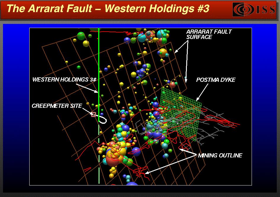
Case study 2: Using seismic reflection to design a mine
 Case study 2: Using seismic reflection to design a mine Rob Knipe, Graham Stuart * and Stephen Freeman Rock Deformation Research & School of Earth and Environment * University of Leeds Seismic Reflection
Case Study: University of Connecticut (UConn) Landfill
 Landfill") Case Study: University of Connecticut (UConn) Landfill Problem Statement:» Locate disposal trenches» Identify geologic features and distinguish them from leachate and locate preferential pathways in fractured
Case Study: University of Connecticut (UConn) Landfill Problem Statement:» Locate disposal trenches» Identify geologic features and distinguish them from leachate and locate preferential pathways in fractured
In situ stress estimation using acoustic televiewer data
 Underground Mining Technology 2017 M Hudyma & Y Potvin (eds) 2017 Australian Centre for Geomechanics, Perth, ISBN 978-0-9924810-7-0 https://papers.acg.uwa.edu.au/p/1710_39_goodfellow/ SD Goodfellow KORE
Site Characterization & Hydrogeophysics
 Site Characterization & Hydrogeophysics (Source: Matthew Becker, California State University) Site Characterization Definition: quantitative description of the hydraulic, geologic, and chemical properties
SCOPE OF INVESTIGATION Simple visual examination of soil at the surface or from shallow test pits. Detailed study of soil and groundwater to a
 Lecture-5 Soil Exploration Dr. Attaullah Shah 1 Today s Lecture Purpose of Soil Exploration Different methods 1. Test trenches and Pits 2. Auger and Wash Boring 3. Rotary Drilling 4. Geophysical Methods
An Introduction to Field Explorations for Foundations
 An Introduction to Field Explorations for Foundations J. Paul Guyer, P.E., R.A. Paul Guyer is a registered mechanical engineer, civil engineer, fire protection engineer and architect with over 35 years
SI Planning & Laboratory Testing for Hill-Site Development
 SI Planning & Laboratory Testing for Hill-Site Development 21 April 2009 IEM Penang Ir. Tan Yean Chin G&P Geotechnics Sdn Bhd Cameron Highlands, 1961 Genting Highland Tower 1993 Bukit Antarabangsa, 1999
GEOTECHNICAL ENGINEERING INVESTIGATION HANDBOOK Second Edition
 GEOTECHNICAL ENGINEERING INVESTIGATION HANDBOOK Second Edition Roy E. Hunt Taylor & Francis Taylor & Francis Croup Boca Raton London New York Singapore A CRC title, part of the Taylor & Francis imprint,
Module 1 : Site Exploration and Geotechnical Investigation
 Objectives In this section you will learn the following Displacement borings Wash boring Auger boring Rotary drilling Percussion drilling Continuous sampling Boring methods of exploration The boring methods
An Introduction to Geophysical Exploration
 An Introduction to Geophysical Exploration Philip Kearey Department of Earth Sciences University of Bristol Michael Brooks Ty Newydd, City Near Cowbridge Vale of Glamorgan Ian Hill Department of Geology
Geologging Imagery, Applications and Geological Interpretation. Shea Altadonna 1, Jim Fulton 2, E.I.T.
 Geologging Imagery, Applications and Geological Interpretation Shea Altadonna 1, Jim Fulton 2, E.I.T. 1 Geologist, Advanced Construction Techniques Inc. 1000 N. West St. Ste 1200, Wilmington, DE 19801;
Guidelines for Site-Specific Seismic Hazard Reports for Essential and Hazardous Facilities and Major and Special-Occupancy Structures in Oregon
 Guidelines for Site-Specific Seismic Hazard Reports for Essential and Hazardous Facilities and Major and Special-Occupancy Structures in Oregon By the Oregon Board of Geologist Examiners and the Oregon
Site Investigations and Geotechnical Risk For Underground Construction Greg Raines, PE
 August 14, 2017 Site Investigations and Geotechnical Risk For Underground Construction Greg Raines, PE Gregory.Raines@Stantec.com Develop Preliminary Geologic / Geotech Conceptual Model for the Project
KDOT Geotechnical Manual Edition. Table of Contents
 KDOT Geotechnical Manual 2007 Edition The KDOT Geotechnical Manual is available two volumes. Both volumes are very large electronic (pdf) files which may take several minutes to download. The table of
Geophysical Exploration in Water Resources Assessment. John Mundell, P.E., L.P.G., P.G. Ryan Brumbaugh, L.P.G. Mundell & Associates, Inc.
 Geophysical Exploration in Water Resources Assessment John Mundell, P.E., L.P.G., P.G. Ryan Brumbaugh, L.P.G. Mundell & Associates, Inc. Presentation Objective Introduce the use of geophysical survey methods
ambiguity in earth sciences IESO Geophysics Section Eddy hartantyo, Lab Geofisika FMIPA UGM
 ambiguity in earth sciences IESO Geophysics Section Eddy hartantyo, Lab Geofisika FMIPA UGM Pelatihan Tahap II IESO Teknik Geologi UGM Februari 2009 1 Introduction Photos from http://www.eegs.org/whatis/
This document downloaded from vulcanhammer.net vulcanhammer.info Chet Aero Marine
 This document downloaded from vulcanhammer.net vulcanhammer.info Chet Aero Marine Don t forget to visit our companion site http://www.vulcanhammer.org Use subject to the terms and conditions of the respective
Instructional Objectives. Why use mass classification? What is rock mass classification? 3 Pillars of empirical design and rock mass classification
 GE 6477 DISCONTINUOUS ROCK 5. Rock Mass Classification and Empirical Design Dr. Norbert H. Maerz Missouri University of Science and Technology (573) 341-6714 norbert@mst.edu Instructional Objectives 1.
Geophysical Site Investigation (Seismic methods) Amit Prashant Indian Institute of Technology Gandhinagar
 Amit Prashant Indian Institute of Technology Gandhinagar") Geophysical Site Investigation (Seismic methods) Amit Prashant Indian Institute of Technology Gandhinagar Short Course on Geotechnical Aspects of Earthquake Engineering 04 08 March, 2013 Seismic Waves
Geophysical Site Investigation (Seismic methods) Amit Prashant Indian Institute of Technology Gandhinagar Short Course on Geotechnical Aspects of Earthquake Engineering 04 08 March, 2013 Seismic Waves
Instructional Objectives
 GE 6477 DISCONTINUOUS ROCK 3. Description of Discontinuities Dr. Norbert H. Maerz Missouri University of Science and Technology (573) 341-6714 norbert@mst.edu Instructional Objectives 1. List the ISRM
Rock slope failure along non persistent joints insights from fracture mechanics approach
 Rock slope failure along non persistent joints insights from fracture mechanics approach Louis N.Y. Wong PhD(MIT), BSc(HKU) Assistant Professor and Assistant Chair (Academic) Nanyang Technological University,
The Mine Geostress Testing Methods and Design
 Open Journal of Geology, 2014, 4, 622-626 Published Online December 2014 in SciRes. http://www.scirp.org/journal/ojg http://dx.doi.org/10.4236/ojg.2014.412046 The Mine Geostress Testing Methods and Design
Seismoelectric Ground-flow DC-4500 Locator
 Seismoelectric Ground-flow DC-4500 Locator Introduction The seismoelectric survey is a new technology combined the electro kinetic potential method and geophysical technology. It is applied directly to
Early Exploration Permit Activity Information
 Early Exploration Permit Activity Information Activities That Require an Early Exploration Permit: Line cutting that is a width greater than 1.5 metres Mechanized stripping of a total surface area of greater
Geotechnical / Geophysical Investigation
 FEATURES TerraDol provides innovative geotechnical and geophysical exploration for civil construction projects including highway, railroad, subway, tunnel, bridge, port, and underground storage projects.
Evaluation of Geological Conditions Ahead of Tunnel Face Using Seismic Tomography between Tunnel and Surface
 Evaluation of Geological Conditions Ahead of Tunnel Face Using Seismic Tomography between Tunnel and Surface Y. Yokota a *, T. Ymamoto a and K. Kurihara a a Kajima Technical Research Institute, 19-1, Tobitakyu
Rogun Hydropower Project
 Rogun Hydropower Project Dam site Geological investigations in the Downstream Right Bank Ascencio Lara Coyne et Bellier Almaty, 11-12 February 2013 Objectives of the presentation As the stability conditions
SEISMIC TOMOGRAPHY MEASUREMENTS IN THE RADIOACTIVE WASTE DISPOSAL SITE IN BÁTAAPÁTI
 Seismic tomography measurements in Bátaapáti SEISMIC TOMOGRAPHY MEASUREMENTS IN THE RADIOACTIVE WASTE DISPOSAL SITE IN BÁTAAPÁTI 1. Introduction PETER TILDY 1, ZSOLT PRONAY 1, ENDRE TÖRÖS 1 As a part of
Rock slope rock wedge stability
 Engineering manual No. 28 Updated: 02/2018 Rock slope rock wedge stability Program: Rock stability File: Demo_manual_28.gsk The aim of the chapter of this engineering manual is to explain a rock slope
BLOCK SIZE AND BLOCK SIZE DISTRIBUTION
 Paper presented at the Workshop on "Reliablity of classification systems" in connection with the GeoEng000 conference, Melbourne, 8 November 000 BLOCK SIZE AND BLOCK SIZE DISTRIBUTION by Arild Palmström,
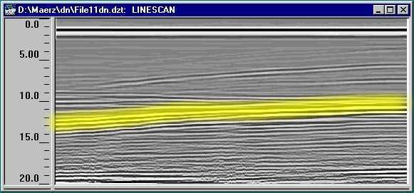
POTENTIAL USE OF GROUND PENETRATING RADAR IN HIGHWAY ROCK CUT STABILITY Norbert H. Maerz* and Wooyoung Kim^ ABSTRACT INTRODUCTION
 Geophysics 2000, Dec. 11-15, 2000, St. Louis, MO, 9 pp. POTENTIAL USE OF GROUND PENETRATING RADAR IN HIGHWAY ROCK CUT STABILITY Norbert H. Maerz* and Wooyoung Kim^ *Rock Mechanics and Explosives Research
Appendix 6 Geotechnical report
 Page 56 Appendix 6 Geotechnical report 1. Introduction The following provides an initial and preliminary description/assessment of the overall geology, the likely ground conditions and preliminary geotechnical
TAKING THE MYSTERY OUT OF USACE S ER DRILLING IN EARTH EMBANKMENT DAMS AND LEVEES
 TAKING THE MYSTERY OUT OF USACE S ER 1110-1-1807 DRILLING IN EARTH EMBANKMENT DAMS AND LEVEES 237 237 237 217 217 217 200 200 200 80 119 27 252 174.59 1 255 255 255 0 0 0 163 163 163 131 132 122 239 65
HOW. HOW vehicle mounted units portable units also available. HOW, WHEN & WHY to Geophysically Log in S.I.?
 HOW, WHEN & WHY to Geophysically Log in S.I.? by Kim Beesley HOW HOW vehicle mounted units portable units also available Access to borehole Depth of borehole sump / rat -hole? 1 HOW? - subject to borehole
The San Andreas Fault Observatory at Depth: Recent Site Characterization Studies and the 2.2-Km-Deep Pilot Hole
 The San Andreas Fault Observatory at Depth: Recent Site Characterization Studies and the 2.2-Km-Deep Pilot Hole Steve Hickman and Bill Ellsworth (USGS) Mark Zoback (Stanford University) and the Pre-EarthScope
MULTIVARIATE ANALYSIS OF BORE HOLE DISCONTINUITY DATA
 Maerz,. H., and Zhou, W., 999. Multivariate analysis of bore hole discontinuity data. Rock Mechanics for Industry, Proceedings of the 37th US Rock Mechanics Symposium, Vail Colorado, June 6-9, 999, v.,
Geological and geotechnical approach for excavation of large unlined rock cavern
 Geological and geotechnical approach for excavation of large unlined rock cavern D. Singh, A. Mandal*, A. Usmani and A. Nanda The degree of uncertainty involved in an underground storage project is relatively
GEOPHYSICAL SITE CHARACTERIZATION IN SUPPORT OF HIGHWAY EXPANSION PROJECT
 GEOPHYSICAL SITE CHARACTERIZATION IN SUPPORT OF HIGHWAY EXPANSION PROJECT * Shane Hickman, * Todd Lippincott, * Steve Cardimona, * Neil Anderson, and + Tim Newton * The University of Missouri-Rolla Department
Final design of Belesar III and Los Peares III Hydropower Projects. (Galicia, Spain).
.") Final design of Belesar III and Los Peares III Hydropower Projects. (Galicia, Spain). J. Baztán and A. Martín Gas Natural Fenosa Engineering, S.L.U, Madrid, Spain. J. M. Galera and D. Santos Subterra Ingeniería
Final design of Belesar III and Los Peares III Hydropower Projects. (Galicia, Spain). J. Baztán and A. Martín Gas Natural Fenosa Engineering, S.L.U, Madrid, Spain. J. M. Galera and D. Santos Subterra Ingeniería
iii CONTENTS vii ACKNOWLEDGMENTS EXECUTIVE SUMMARY INTRODUCTION Study Area Data Sources Preparation of Geologic Maps
 CONTENTS ACKNOWLEDGMENTS EXECUTIVE SUMMARY INTRODUCTION Study Area Data Sources Preparation of Geologic Maps GEOLOGY Bedrock Geology Succession and Distribution Structural Features Description of Bedrock
LECTURE 10. Module 3 : Field Tests in Rock 3.6 GEOPHYSICAL INVESTIGATION
 LECTURE 10 3.6 GEOPHYSICAL INVESTIGATION In geophysical methods of site investigation, the application of the principles of physics are used to the study of the ground. The soil/rock have different characteristics
Understanding the Mechanical Behavior of Drilling-induced Tensile Fractures through Photoelasticity Lab Tests Conducted on Glass Cubes
 Understanding the Mechanical Behavior of Drilling-induced Tensile Fractures through Photoelasticity Lab Tests Conducted on Glass Cubes Qing Jia, Douglas R. Schmitt, Randy Kofman and Xiwei Chen University
Lima Project: Seismic Refraction and Resistivity Survey. Alten du Plessis Global Geophysical
 Lima Project: Seismic Refraction and Resistivity Survey Alten du Plessis Global Geophysical Report no 0706/2006 18 December 2006 Lima Project: Seismic Refraction and Resistivity Survey by Alten du Plessis
Pressure Grouting of Fractured Bedrock to Control Acid Mine Drainage
 WATER RESOURCES AT RISK May 14-18, 1995 Denver American Institute of Hydrology Pressure Grouting of Fractured Bedrock to Control Acid Mine Drainage S. A. Effner, G. D. Vandersluis, and V. Straskraba Hydro-Geo
Geophysical Methods for Screening and Investigating Utility Waste Landfill Sites in Karst Terrain
 Geophysical Methods for Screening and Investigating Utility Waste Landfill Sites in Karst Terrain Gary Pendergrass, PE, RG, F.NSPE Principal Geological Engineer Kansas City Geotechnical Conference 2017
Does the SDCP need inputs from geology?
 The British Geological Survey s Experience and Expertise in Supporting Projects such as the Sirte Depression Connection Project David Ovadia Director of International Kingsley Dunham Centre Keyworth Nottingham
Optical and Acoustic Televiewer Borehole Logging Improved Oriented Core Logging Techniques
 Optical and Acoustic Televiewer Borehole Logging Improved Oriented Core Logging Techniques Tom Eliassen, VTrans; Dorothy Richter, Hager-Richter Geoscience; Heather Crow, Peter Ingraham & Trevor Carter,
7. Foundation and Slope Stability
 The Asian Nuclear Safety Network 7. Foundation and Slope Stability (SER 2.5.4 & 2.5.5) Taek-Mo SHIM k147stm@kins.re.kr Korea Institute of Nuclear Safety Structural Systems and Site Evaluation Department
Geotechnical Monitoring for Safe Excavation of Large Rock Cavern: A Case Study
 The 31st International Symposium on Automation and Robotics in Construction and Mining (ISARC 2014) Geotechnical Monitoring for Safe Excavation of Large Rock Cavern: A Case Study A.Mandal a, C. Kumar b,
Before writing the discipline examinations, candidates must have passed, or have been exempted from, the Basic Studies Examinations.
 INTRODUCTION The Canadian Engineering Qualifications Board of Engineers Canada issues the Examination Syllabus that includes a continually increasing number of engineering disciplines. Each discipline
SLOPE STABILITY EVALUATION AND ACCEPTANCE STANDARDS
 INFORMATION BULLETIN / PUBLIC - BUILDING CODE REFERENCE NO.: LABC 7006.3, 7014.1 Effective: 01-01-2017 DOCUMENT NO.: P/BC 2017-049 Revised: 12-21-2016 Previously Issued As: P/BC 2014-049 SLOPE STABILITY
Effects of depositional and diagenetic heterogeneitites on fluid flow in Plio -- Pleistocene reefal carbonates of the Southern Dominican Republic
 Viviana Díaz was born in Puerto Rico and received her undergraduate degree from the University of Puerto Rico and her Master's at the University of North Carolina. She is currently working on her PhD at
Site investigation in rock
 Site investigation in rock masses Geotechnical Core Drilling & Logging Core Orientation Borehole Surveying Logging g Core Borehole Log Face Mapping Scanline Data Analysis Influence of Joints Orientation
Mechanical Wave Measurements. Electromagnetic Wave Techniques. Geophysical Methods GEOPHYSICAL SITE CHARACTERIZATION. Mechanical Wave Geophysics
 Geophysical Methods GEOPHYSICAL SITE CHARACTERIZATION Mechanical Wave Measurements Electromagnetic Wave Techniques Mechanical Wave Measurements Crosshole Tests (CHT) Downhole Tests (DHT) Spectral Analysis
In-situ Experiments on Excavation Disturbance in JNC s Geoscientific Research Programme
 In-situ Experiments on Excavation Disturbance in JNC s Geoscientific Research Programme H. Matsui, K. Sugihara and T. Sato Japan Nuclear Cycle Development Institute, Japan Summary The HLW disposal program
Multiscale Seismic Signature of a Small Fault Zone in a Carbonate Reservoir: Relationships Between V P Imaging, Fault Zone Architecture and Cohesion*
 Multiscale Seismic Signature of a Small Fault Zone in a Carbonate Reservoir: Relationships Between V P Imaging, Fault Zone Architecture and Cohesion* Pierre Jeanne 1,2, Yves Guglielmi 2, and Frédéric Cappa
GPR AS A COST EFFECTIVE BEDROCK MAPPING TOOL FOR LARGE AREAS. Abstract
 GPR AS A COST EFFECTIVE BEDROCK MAPPING TOOL FOR LARGE AREAS Dr. Jutta L. Hager, Hager GeoScience, Inc., Waltham, MA Mario Carnevale, Hager GeoScience, Inc., Waltham, MA Abstract Hager GeoScience, Inc.
Principles of Applied Geophysics
 Principles of Applied Geophysics Fifth edition D.S. Parasnis Professor emeritus of Applied Geophysics Department of Applied Geophysics, University ofluled, Lulea, Sweden Fellow of the Royal Swedish Academy
GEOTECHNICAL POLICIES AND PROCEDURES MANUAL CHAPTER 5 GEOTECHNICAL INVESTIGATION PLANNING GUIDELINES
 GEOTECHNICAL POLICIES AND PROCEDURES MANUAL CHAPTER 5 GEOTECHNICAL INVESTIGATION PLANNING GUIDELINES GEOTECHNICAL INVESTIGATION PLANNING GUIDELINES 5-i TABLE OF CONTENTS 1. PURPOSE... 1 2. INTRODUCTION...
An Hypothesis Concerning a Confined Groundwater Zone in Slopes of Weathered Igneous Rocks
 Symposium on Slope Hazards and Their Prevention: 8-10 May, 2000, Hong Kong, PRC An Hypothesis Concerning a Confined Groundwater Zone in Slopes of Weathered Igneous Rocks J. J. Jiao and A. W. Malone Department
Downhole Seismic Velocity Logging Test
 Objective Downhole Seismic Velocity Logging Test In this experiment, Velocity Logging Test (Downhole method) is done to find the physical properties of the soil ground from site investigation. Velocity
ontribution of Geotechnical and Rock echanics design to vertical shaft nking and design
 ontribution of Geotechnical and Rock echanics design to vertical shaft nking and design CONTENTS Geological and Geotechnical investigations Pre-sink Examples of Pre-sinking in soft soils Ancillary excavations
1. Resistivity of rocks
 RESISTIVITY 1) Resistivity of rocks 2) General principles of resistivity surveying 3) Field procedures, interpretation and examples 4) Summary and conclusions INDUCED POLARIZATION 1) General principles
Microseismic Aids In Fracturing Shale By Adam Baig, Sheri Bowman and Katie Jeziorski
 AUGUST 2014 The Better Business Publication Serving the Exploration / Drilling / Production Industry Microseismic Aids In Fracturing Shale By Adam Baig, Sheri Bowman and Katie Jeziorski KINGSTON, ONTARIO
Predicting rock conditions ahead of the face
 Predicting rock conditions ahead of the face Dr Thomas Dickmann, Product Manager Geophysics, Amberg Technologies AG Seismic methods of predicting rock conditions ahead of the tunnel face have developed
Geophysics and Mapping. presented by: Stephen Brown
 Geophysics and Mapping presented by: Stephen Brown Recommended book for INIGEMM Geophysics for the mineral exploration geoscientist, by Michael Dentith and Stephen Mudge, Cambridge University Press, 2014.
 UNIT I SITE INVESTIGATION AND SELECTION OF FOUNDATION Types of boring 1.Displacement borings It is combined method of sampling & boring operation. Closed bottom sampler, slit cup, or piston type is forced
Application of Geophysical Methods in Tunnel Exploration
 5th International Conference on Civil, Architectural and Hydraulic Engineering (ICCAHE 2016) Application of Geophysical Methods in Tunnel Exploration Ding Hai-hong1,a, Jiang Wei-wei2,b 1. East China Mineral
GEOLOGICAL FRACTURE MAPPING USING ELECTROMAGNETIC GEOTOMOGRAPHY. A.L. Ramirez, F.J. Deadrick and R.J. Lytle
 GEOLOGICAL FRACTURE MAPPING USING ELECTROMAGNETIC GEOTOMOGRAPHY A.L. Ramirez, F.J. Deadrick and R.J. Lytle Lawrence Livermore National Laboratory Livermore, California 94550 ABSTRACT This article describes
Monitoring and Characterization of the Meadowview Lane Landslide: Boyd County, KY
 Monitoring and Characterization of the Meadowview Lane Landslide: Boyd County, KY Matt Crawford Appalachian Coalition for Geologic Hazards in Transportation 13 th Annual Technical Forum Harrisonburg, VA
FRACTURE REORIENTATION IN HORIZONTAL WELL WITH MULTISTAGE HYDRAULIC FRACTURING
 SPE Workshop OILFIELD GEOMECHANICS Slide 1 FRACTURE REORIENTATION IN HORIZONTAL WELL WITH MULTISTAGE HYDRAULIC FRACTURING A. Pimenov, R. Kanevskaya Ltd. BashNIPIneft March 27-28, 2017 Moscow, Russia Slide
Applied Geophysics for Environmental Site Characterization and Remediation
 Applied Geophysics for Environmental Site Characterization and Remediation MSECA Webinar September 24, 2015 John Mundell, P.E., L.P.G. Ryan Brumbaugh, L.P.G. MUNDELL & ASSOCIATES, INC. Webinar Objective
The process of determining the layers of natural soil deposits that will underlie a proposed structure and their physical properties is generally
 The process of determining the layers of natural soil deposits that will underlie a proposed structure and their physical properties is generally referred to as sub surface investigation 2 1 For proper
Early Exploration Plan Activity Information
 Early Exploration Plan Activity Information Activities That Require an Early Exploration Plan: Line cutting that is a width of 1.5 metres or less; Geophysical surveys on the ground requiring the use of
Geological Mapping using Geophysics
 Geological Mapping using Geophysics Pugin, A.J.M. and T.H. Larson Illinois State Geological Survey, 615 E Peabody Dr., Champaign, IL 61820; E-mail: A.J.M. Pugin at pugin@isgs.uiuc.edu Mapping Techniques.
Stress Damage in Borehole and Rock Cores; Developing New Tools to Update the Stress Map of Alberta
 Stress Damage in Borehole and Rock Cores; Developing New Tools to Update the Stress Map of Alberta Qing Jia, University of Alberta, Edmonton qjia@ualberta.ca and Randy Kofman, University of Alberta, Edmonton
DESIGN AND CONSTRUCTION OF LARGE
 DESIGN AND CONSTRUCTION OF LARGE TUNNELS IN SOIL AND FAULTED ROCK SENTVID TUNNEL MOTORWAY BYPASS OF LJUBLJANA Josef Daller, ic consulenten, Vienna - Austria International NATM Workshop Singapore 2010 LAYOUT
Geotechnical data from optical and acoustic televiewer surveys
 Geotechnical data from optical and acoustic televiewer surveys by Farrin De Fredrick MAusIMM, Senior Geotechnical Engineer; Ta Nguyen AIG, Geotechnical Engineer; Clive Seymour MAusIMM, Principal; and Gary
ENGINEERING GEOLOGY AND ROCK ENGINEERING
 1 ENGINEERING GEOLOGY AND ROCK ENGINEERING HANDBOOK NO. 2 Norwegian Group for Rock Mechanics (NBG) www.bergmekanikk.com Prepared in co-operation with Norwegian Tunnelling Society (NFF) Issued in 2000 SECRETARIAT:
Session - Road Building Fundamentals
 Session - Road Building Fundamentals Topic Foundation Conditions Materials & Performance of Facility Soil/Rock Properties Dave Peterson, P.G., SVP, Principal Geologist November 14, 2013 2013 Arizona Pavements/Materials
GUIDELINES FOR OPEN PIT SLOPE DESIGN EDITORS: JOHN READ, PETER STACEY # & CSIRO. J x PUBLISHING
 GUIDELINES FOR OPEN PIT SLOPE DESIGN EDITORS: JOHN READ, PETER STACEY # & CSIRO J x PUBLISHING S Contents Preface and acknowledgments xiii 1 Fundamentals of slope design 1 Peter Stacey 1.1 Introduction
A new design approach for highway rock slope cuts based on ecological environment protection
 A new design approach for highway rock slope cuts based on ecological environment protection T. Lian-jin, Z. Li, W. Yunjie, W. Guang-yuan & Z. Yin-tao College of Architecture and Civil Engineering, Beijing
MAPPING BEDROCK: Verifying Depth to Bedrock in Calumet County using Seismic Refraction
 MAPPING BEDROCK: Verifying Depth to Bedrock in Calumet County using Seismic Refraction Revised December 13, 2011 Dave Hart Wisconsin Geological and Natural History Survey INTRODUCTION Seismic refraction
Engineering Geophysical Application to Mine Subsidence Risk Assessment
 Engineering Geophysical Application to Mine Subsidence Risk Assessment By: Kanaan Hanna, Sr. Mining Engineer Steve Hodges, Sr. Geophysicist Jim Pfeiffer, Sr. Geophysicist Dr. Keith Heasley, Professor West
Rock Suitability Classification for POPLU
 The research leading to these results has received funding from the European Union's European Atomic Energy Community's (Euratom) Seventh Framework Programme FP7/2011-2013, 2013, under Grant Agreement
A. Baiocchi 1, W. Dragoni 2, F. Lotti 1, S.M. Piacentini 2, V. Piscopo 1
 A. Baiocchi 1, W. Dragoni 2, F. Lotti 1, S.M. Piacentini 2, V. Piscopo 1 (1) Department of Ecological and Biological Sciences, University of Tuscia, Viterbo, Italy (2) Department of Physics and Geology,
A25 Very High Resolution Hard Rock Seismic Imaging for Excavation Damage Zone Characterisation
 A25 Very High Resolution Hard Rock Seismic Imaging for Excavation Damage Zone Characterisation C. Cosma* (Vibrometric Oy), N. Enescu (Vibrometric Oy) & E. Heikkinen (Pöyry Finland Oy) SUMMARY Seismic and
OWNER OPERATOR: BLACKWATER EXPLORATIONS LTD. REPORT ON SEISMIC REFRACTION SURVEY PLACER GOLD EXPLORATION
 OWNER OPERATOR: BLACKWATER EXPLORATIONS LTD. REPORT ON SEISMIC REFRACTION SURVEY PLACER GOLD EXPLORATION CARIBOO MINING DISTRICT NTS 93G CLAIM PC682023 Latitude 53 13 35.64 Longitude 122 49 40.65 by Russell