Session - Road Building Fundamentals
|
|
|
- Julian Chapman
- 5 years ago
- Views:
Transcription


1 Session - Road Building Fundamentals Topic Foundation Conditions Materials & Performance of Facility Soil/Rock Properties Dave Peterson, P.G., SVP, Principal Geologist November 14, Arizona Pavements/Materials Conference


 Key soil")
2 Outline of Presentation Define need for understanding soil/rock properties Typical problems of soils- resulting in failures Geo-hazards Characterization methods (example project) Key soil parameters associated with design
3 Need for Determining Foundation Materials Properties Certain soils/rocks can contribute to: Poor roadway performance, Foundation failures, Geologic hazards and An elevated risk of safety to the travelling public 2

4 Common Problematic Conditions Low density, high porosity soils can result in collapsible conditions Common in sheet flow conditions on alluvial fan/flats Variable lithologies and associated change in densities/cementation/plasticity/firmness, hardess over short distances can result in differential settlement Common in a lenticular deposits in alluvial/fluvial settings or spanning different geologic units High plasticity deposits exposed to variable water conditions can result in heaving conditions Commonly associated with weathered basalts, and lakebed/fluvial clays derived from volcanic ash. Exotic colored clays are typically ash derived. Loose finer grained deposits over more open graded deposits can produce piping failures Natural environment Embankment fills 3

5 Collapsible Conditions Collapse/piping feature associated with a low gradient alluvial fan surface where material typically was deposited quickly in a flash flood sheet flood event 4
 and 130 of fill, with a MSE embankment at")
6 Differential Settlement Potential Sugarloaf Mountain Bridge Arizona Approach, Hoover Dam Bypass Founded on combination of rock (rhyolite & dacite) and 130 of fill, with a MSE embankment at Abutment 2


7 Sugarloaf Mountain Bridge Arizona Approach Multiple-point borehole rod extensometers Abutment 2 to monitor settlement


8 Heaving Conditions Wavy asphalt caused by high plasticity basin-fill claystone subgrade 7


9 Piping Fine grained fill over granular alluvium 8
10 Geo-Hazards Other geologic conditions that pose a risk to roadway performance and risk to travelling public if unaddressed or not recognized: Slope stability Fill slopes Rock slopes including rock fall Landslides Scour Sinkholes Ground subsidence and earth fissures 9

11 Bedrock Volcanic Tuff Slopes/Foundations Goal: Produce a stable cut slope for Arizona Skewback on Hoover Dam Bypass In-situ testing: downhole seismic, goodman jack, RQD & optical televiewer Lab: Unconfined compression, point load, density, splitting tensile strength, dynamic & static Young s modulus, creep in unconfined compression Important properties include rock strength of ash tuff to both support the slope and the foundation along the canyon wall. Based on lab and in-situ testing, bearing capacities of the rock was established to be 2000psi for all footings except the Az Skewback which was determined to be 1200psi Slope stability also dependant upon fractures and faults in and near the walls of the excavation 10

12 Geo-Hazards Rockfall Containment & Slope Geometry Considerations Rock slope on SR 77, near Winkelman, Az Stable slope but rockfall can be launched off inclined surfaces sloping toward the roadway 11

13 Geo-Hazard SR 87 slide Soil nail wall built on ancient landslide 12

14 Scour US 93 Loose fine grained deposits below CMP subject to scour 13

15 Geo-Hazards Sinkholes Sinkholes near Snowflake, Az Features result from surface propagation of roof collapse or piping into open solution cavity at depth. Gypsum beds in Supai Fm in this case More common in areas underlain by sedimentary deposits, including limestone, gypsum, salt. Smaller sinkholes can also form from piping into narrower open fissures. Sinkholes in Phoenix Valley? 14

16 Geo-Hazard Sinkholes Sink hole in New Mexico The upper, smaller sinkhole appeared in 1980, the larger lower sinkhole appeared in 2002, and activity for a future sinkhole is apparent in the InSAR image to the east of the lower sinkhole. 15
17 Geo-Hazard Earth Fissures Occurs in basin fill settings with history of groundwater pumping InSAR imagery can aid in assessing ground subsidence areas 16
18 Steps in Characterizing Soil/Rock Parameters for Design Purposes Understand the geologic setting to anticipate general material types and types of deposits Area imagery Topographic relief Geomorpholgy Geologic maps Perform a geologic reconnaissance Establish a field investigation plan suited for the project and the variability of the geologic units Drill holes, auger, core, rotary, percussion Backhoe pits/trenches grain size & density testing at grade sections forming subgrade Geologic mapping correlation of units, predictability (variable methods) Seismic surveys, refraction, ReMi Down hole televiewers Down hole seismic 17
19 Steps in Characterizing Soil/Rock Parameters for Design Purposes Establish a laboratory testing program to further characterize material properties Typical tests Sieve Analysis Plasticity Index (Atterberg Limits) Moisture Content Density Rings samples - soils, Bulk Density - rock Moisture Density Relations (Proctor) R-value Direct Shear Point Load Unconfined compression ph & Resistivity Chlorides & Sulfates ADOT Nutrient Group Suite 18
20 Example - Hoover Dam Bypass Elements of Investigation Laser scanning Geologic mapping Conventional surface mapping, where practical with canyon wall photo review Helicopter reconnaissance Canyon wall mapping during rappels in steep near vertical terrain Point cloud image review (structural features) Canyon wall drilling Oriented Optical Televiewer borehole logging In-situ testing NX borehole (Goodman) jack Downhole seismic surveys
21 Geotechnical Investigation Challenges Hoover Dam Bypass Difficult Access Rugged terrain with high relief and near vertical canyon walls Overhead transmission lines Site Related Design Features Steep cuts (towers, U.S. 83, existing topography) Rockfall containment Structure foundations Other Factors Variable geologic conditions Rock types Strengths Discontinuities Safety during field operations Field crews Public access Security associated with Hoover Dam operations Post-9/11 restrictions Restricted air space Daily coordination w/ authorities

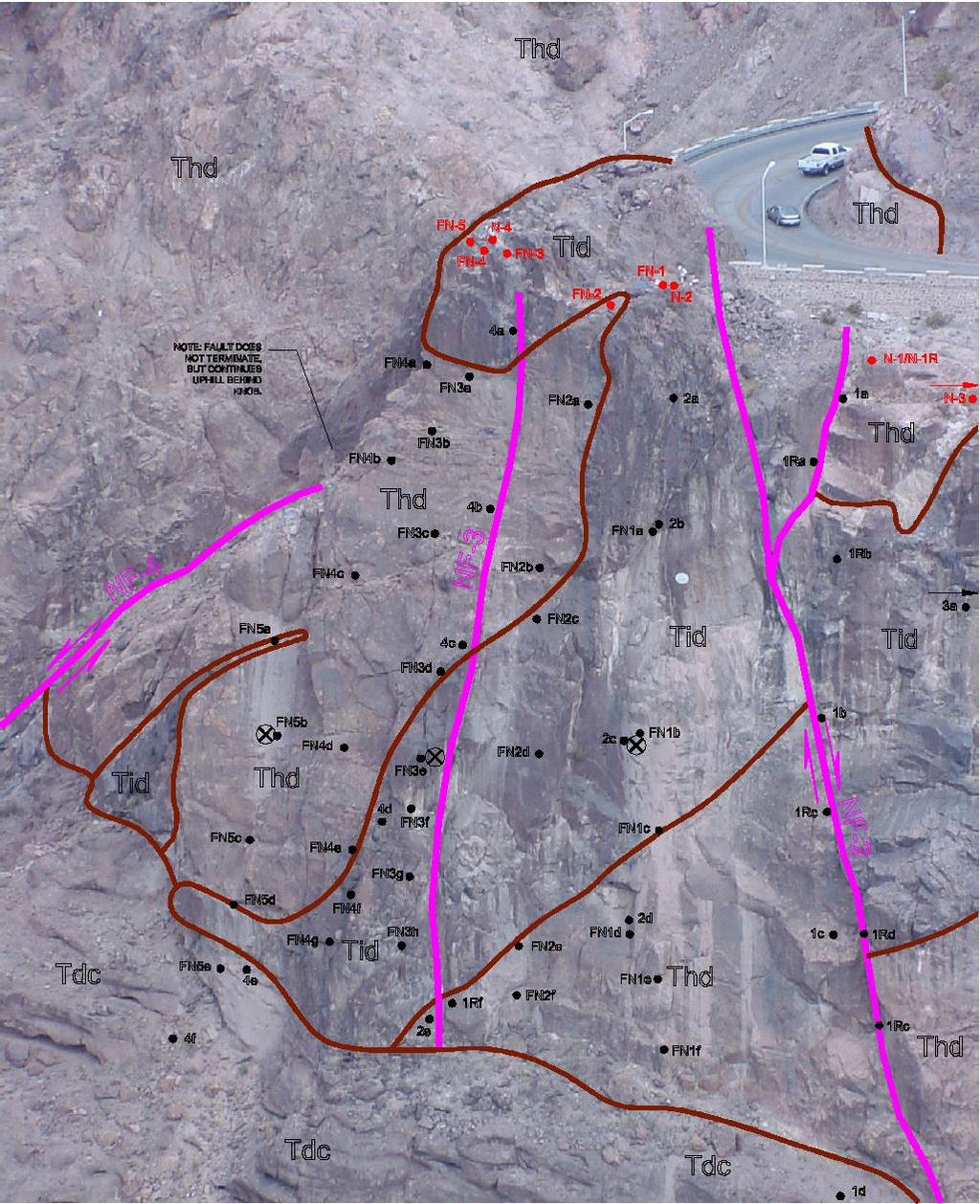
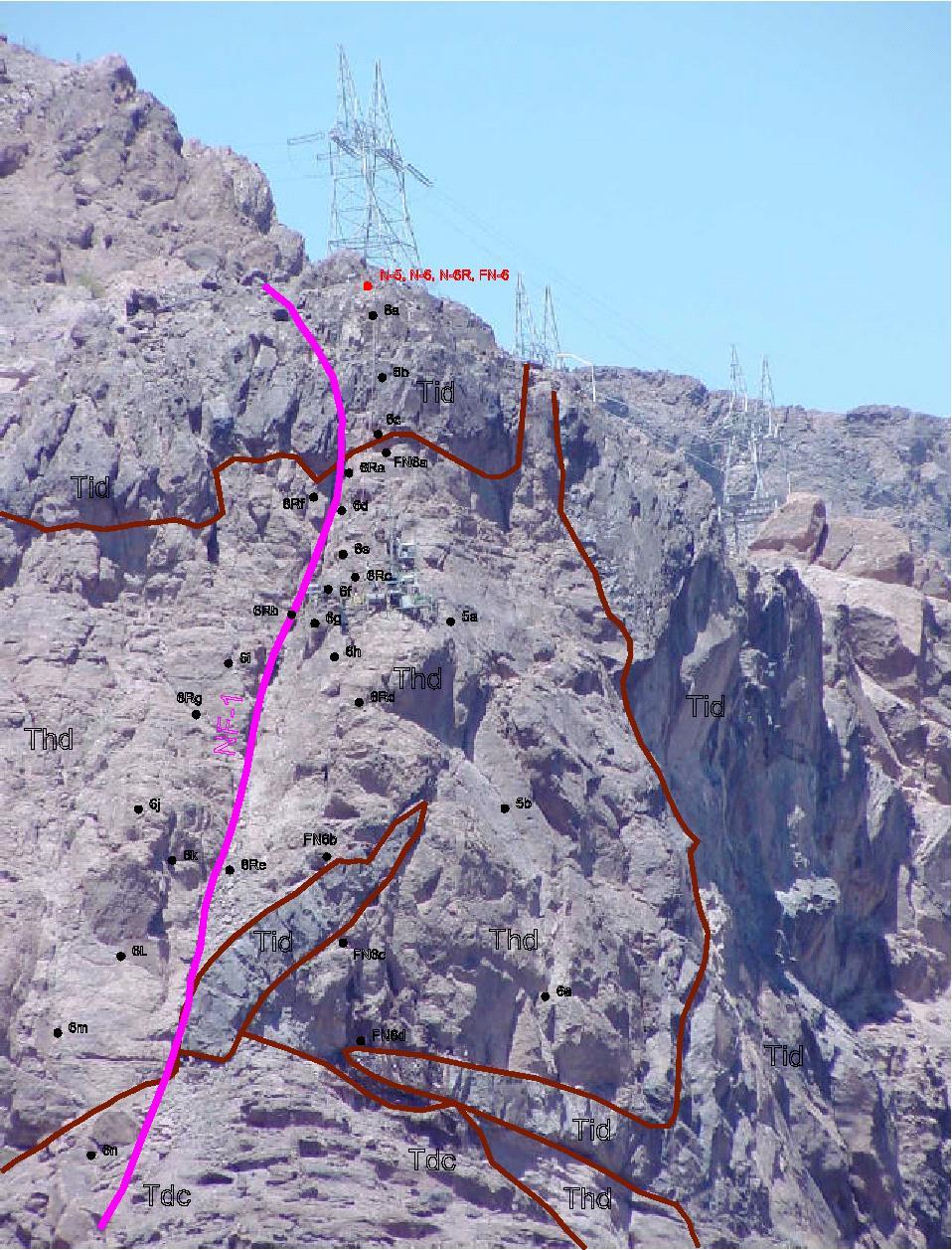
22 Laser Point Cloud-Nevada Survey Target Fault Photo-Lineament Evaluation Fault Identification


23 Rappel Mapping Skewback Location Technical skills Geologic Inspections Rock Quality Fracture orientations Fracture conditions Rope skills/training Safety and security

24 Helicopter Recon Nevada Skewback Alignment
 Limited access required variably inclined boreholes to reach foundation depths")
25 Canyon Wall Drilling Steep terrain with overhead power lines required portable rigs with access assisted by: Helicopter Crane Track Articulated backhoe (Spyder) Limited access required variably inclined boreholes to reach foundation depths


26 In-Situ Testing Downhole Seismic Borehole Jack Means of estimating rock mass modulus from field data


27 Downhole Seismic Testing Arizona Skewback Nevada Skewback
28 Depth, feet Seismic Results - Hoover Dam Bypass Boring R-13 Downhole Seismic Results Time, milliseconds f/s Tuff of Hoover Dam Thd 22,500 f/s 7000 f/s open fracture 40 Dike Tid 26,670 f/s 60 Thd 5000 f/s 10,000 f/s 5000 f/s 1st arrivals interpretations Geologic contacts 80? 5000 f/s 100 Dike Tid Dam conglomerate Tdc 11,000 f/s 120 Note: 1st arrival signals were consistent throughout borehole
29 Dry density (unit weight), pounds per cubic foot (pcf) Porosity, % SUBSURFACE INVESTIGATION Surface Seismic Investigations Relationship between Seismic Velocity and Dry Density Seismic Velocity as a Function of Unit Weight P-wave Velocity, f/s (Poisson's ratio of 0.33 assumed) Physical gel geomaterials: including granular deposits and fractured, weathered rock masses Specific gravity of 2.65 g/cc assumed S-wave velocity, f/s (Poisson's ratio of 0.33 assumed) physical gel trend chemical gel trend Hoover Dam Bypass Tuff streambed materials inner log scale porosity scale P-wave scale Chemical gel geomaterials; such as intact, unfractured limestone,
30 Rock Mass Strength Hoover Dam Bypass
31 Geology-Nevada Skewback


32 Nevada Skewback Excavation 3-D rendering with projected geology Borehole projections

33 GEOLOGIC SETTING - REGIONAL Regional Setting Basin and Range Hieroglyphic Mtns. Quarternary Alluvium Local Setting Western Alignment Agua Fria River Channel Eastern Alignment
34 Key Parameters Required for Roadway/Pavement projects Subgrade conditions and performance factors Continuity of deposits and suitable geologic units Gradation Plasticity Moisture content & groundwater Density of in-situ soils R-values, tested & correlated to establish a minimum construction value Proctor values establish compaction requirement for embankment fill forming the new subgrade Seismic wave velocities existing profile characterization earthwork factors fro using material as embankment fill Corrosivity of soils ph & resistivity to establish type of metal piping required including thickness, type of metal or coating types Sulfate & Chloride content of soils evaluate reaction with concrete type of cement to resist gypsiferous soils require type V cement 33

35 Unified Soil Classification System 34
KDOT Geotechnical Manual Edition. Table of Contents
 KDOT Geotechnical Manual 2007 Edition The KDOT Geotechnical Manual is available two volumes. Both volumes are very large electronic (pdf) files which may take several minutes to download. The table of
Module 9 : Foundation on rocks. Content
 FOUNDATION ON ROCKS Content 9.1 INTRODUCTION 9.2 FOUNDATION TYPES ON ROCKS 9.3 BEARING CAPCITY- SHALLOW FOUNDATION 9.3.1 Ultimate bearing capacity 9.3.2 Safe bearing pressure 9.3.3 Estimation of bearing
Underground Risk Management Course Marina Del Rey, California November, Geotechnical Data Reports. Greg Raines, PE
 Underground Risk Management Course Marina Del Rey, California November, 2018 Geotechnical Data Reports Greg Raines, PE Gregory.Raines@Stantec.com Introduction What is a Geotechnical Data Report? The GDR
Chapter 12 Subsurface Exploration
 Page 12 1 Chapter 12 Subsurface Exploration 1. The process of identifying the layers of deposits that underlie a proposed structure and their physical characteristics is generally referred to as (a) subsurface
Impact : Changes to Existing Topography (Less than Significant)
") 4.2 Land Resources 4.2.1 Alternative A Proposed Action Impact 4.2.1-1: Changes to Existing Topography (Less than Significant) Development of the project site would involve grading and other earthwork as
4.2 Land Resources 4.2.1 Alternative A Proposed Action Impact 4.2.1-1: Changes to Existing Topography (Less than Significant) Development of the project site would involve grading and other earthwork as
GEOTECHNICAL ENGINEERING INVESTIGATION HANDBOOK Second Edition
 GEOTECHNICAL ENGINEERING INVESTIGATION HANDBOOK Second Edition Roy E. Hunt Taylor & Francis Taylor & Francis Croup Boca Raton London New York Singapore A CRC title, part of the Taylor & Francis imprint,
The process of determining the layers of natural soil deposits that will underlie a proposed structure and their physical properties is generally
 The process of determining the layers of natural soil deposits that will underlie a proposed structure and their physical properties is generally referred to as sub surface investigation 2 1 For proper
ENCE 3610 Soil Mechanics. Site Exploration and Characterisation Field Exploration Methods
 ENCE 3610 Soil Mechanics Site Exploration and Characterisation Field Exploration Methods Geotechnical Involvement in Project Phases Planning Design Alternatives Preparation of Detailed Plans Final Design
10. GEOTECHNICAL EXPLORATION PROGRAM
 Geotechnical site investigations should be conducted in multiple phases to obtain data for use during the planning and design of the tunnel system. Geotechnical investigations typically are performed in
3.18 GEOLOGY AND SOILS
 3.18 GEOLOGY AND SOILS This section discusses geologic resource concerns as they relate to the environment, public safety, and project design both during construction and after completion of the project.
Engineer. Engineering. Engineering. (in-ja-neer ) A person trained and skilled in any of the various branches of engineering: a civil engineer
 A person trained and skilled in any of the various branches of engineering: a civil engineer") Engineer (in-ja-neer ) A person trained and skilled in any of the various branches of engineering: a civil engineer (Random House Webster s College Dictionary, 1991) CE100 Introduction to Civil Geotechnical
Engineer (in-ja-neer ) A person trained and skilled in any of the various branches of engineering: a civil engineer (Random House Webster s College Dictionary, 1991) CE100 Introduction to Civil Geotechnical
3.12 Geology and Topography Affected Environment
 3 Affected Environment and Environmental Consequences 3.12 Geology and Topography 3.12.1 Affected Environment 3.12.1.1 Earthquakes Sterling Highway MP 45 60 Project Draft SEIS The Kenai Peninsula is predisposed
Geotechnical Investigation
 2015 Cal Poly Pomona, Portland State University, and others. See full permissions statement at end of document. Civil Engineering Writing Project - Genre Unit 3 Geotechnical Site Investigation Report What
GEOTECHNICAL POLICIES AND PROCEDURES MANUAL CHAPTER 5 GEOTECHNICAL INVESTIGATION PLANNING GUIDELINES
 GEOTECHNICAL POLICIES AND PROCEDURES MANUAL CHAPTER 5 GEOTECHNICAL INVESTIGATION PLANNING GUIDELINES GEOTECHNICAL INVESTIGATION PLANNING GUIDELINES 5-i TABLE OF CONTENTS 1. PURPOSE... 1 2. INTRODUCTION...
Boreholes. Implementation. Boring. Boreholes may be excavated by one of these methods: 1. Auger Boring 2. Wash Boring 3.
 Implementation Boreholes 1. Auger Boring 2. Wash Boring 3. Rotary Drilling Boring Boreholes may be excavated by one of these methods: 4. Percussion Drilling The right choice of method depends on: Ground
IAEA SAFETY STANDARDS Geotechnical Aspects of Site Evaluation and Foundations in NPPs, NS-G-3.6
 IAEA SAFETY STANDARDS Geotechnical Aspects of Site Evaluation and Foundations in NPPs, NS-G-3.6 Regional Workshop on Volcanic, Seismic, and Tsunami Hazard Assessment Related to NPP Siting Activities and
Introduction to Soil Mechanics Geotechnical Engineering
 Introduction to Soil Mechanics Geotechnical Engineering Dr. Attaullah Shah ground SIVA 1 Soil Mechanics= Soil+Mechanics Branch of Science dealing with the structure, Engineering properties and reactions
B-1 BORE LOCATION PLAN. EXHIBIT Drawn By: 115G BROOKS VETERINARY CLINIC CITY BASE LANDING AND GOLIAD ROAD SAN ANTONIO, TEXAS.
 N B-1 SYMBOLS: Exploratory Boring Location Project Mngr: BORE LOCATION PLAN Project No. GK EXHIBIT Drawn By: 115G1063.02 GK Scale: Checked By: 1045 Central Parkway North, Suite 103 San Antonio, Texas 78232
An Introduction to Field Explorations for Foundations
 An Introduction to Field Explorations for Foundations J. Paul Guyer, P.E., R.A. Paul Guyer is a registered mechanical engineer, civil engineer, fire protection engineer and architect with over 35 years
Geology 229 Engineering Geology. Lecture 7. Rocks and Concrete as Engineering Material (West, Ch. 6)
") Geology 229 Engineering Geology Lecture 7 Rocks and Concrete as Engineering Material (West, Ch. 6) Outline of this Lecture 1. Rock mass properties Weakness planes control rock mass strength; Rock textures;
Geology 229 Engineering Geology Lecture 7 Rocks and Concrete as Engineering Material (West, Ch. 6) Outline of this Lecture 1. Rock mass properties Weakness planes control rock mass strength; Rock textures;
Gotechnical Investigations and Sampling
 Gotechnical Investigations and Sampling Amit Prashant Indian Institute of Technology Gandhinagar Short Course on Geotechnical Investigations for Structural Engineering 12 14 October, 2017 1 Purpose of
GEOL 314 Engineering Geology
 GEOL 314 Engineering Geology Dr. Robert Mitchell ES234 Winter 2013 650-3591 robert.mitchell@wwu.edu http://kula.geol.wwu.edu/rjmitch/ Office Hours: MWF 2-3:00 pm or by arrangement Text: Geotechnical Engineering
GEOTECHNICAL INVESTIGATION REPORT INFRASTRUCTURE PVT LTD
 GEOTECHNICAL INVESTIGATION REPORT Client : TAEIN CONSTRUCTION & INFRASTRUCTURE PVT LTD Office address : Flat No.104, A -Wing,1st floor,gloria Park, Paranjape Scheme, Bavdhan Khurd, Chandni Chowk, Pune
Amistad Dam Investigation and Oversight: Karst- Founded Dam on the USA-Mexico Border
 Amistad Dam Investigation and Oversight: Karst- Founded Dam on the USA-Mexico Border Brook Brosi, CPG, PG USACE Lisa Nowicki Perks, PG USACE Kimberly Heenan, PE AECOM US Army Corps of Engineers BUILDING
FUNDAMENTALS OF ENGINEERING GEOLOGY
 FUNDAMENTALS OF ENGINEERING GEOLOGY Prof. Dr. HUSSEIN HAMEED KARIM Building and Construction Engineering Department 2012 Preface The impulse to write this book stemmed from a course of geology given by
SITE INVESTIGATION 1
 SITE INVESTIGATION 1 Definition The process of determining the layers of natural soil deposits that will underlie a proposed structure and their physical properties is generally referred to as site investigation.
IV. ENVIRONMENTAL IMPACT ANALYSIS G. GEOLOGY AND SOILS
 IV. ENVIRONMENTAL IMPACT ANALYSIS G. GEOLOGY AND SOILS The following section is a summary of the geotechnical report conducted for the proposed project. The Report of Geotechnical Investigation Proposed
Geotechnical Investigation Juneau Seawalk - Taku Fisheries to Miner s Wharf Juneau, Alaska DM&A Job No
 Duane Miller & Associates 5821 Arctic Boulevard, Suite A Anchorage, AK 99518-1654 (907) 644-3200 Fax 644-0507 Arctic & Geotechnical Engineering May 4, 2006 Tetra Tech/KCM, Inc. 1971 First Avenue Seattle,
7. Foundation and Slope Stability
 The Asian Nuclear Safety Network 7. Foundation and Slope Stability (SER 2.5.4 & 2.5.5) Taek-Mo SHIM k147stm@kins.re.kr Korea Institute of Nuclear Safety Structural Systems and Site Evaluation Department
US82 ROCKFALL MITIGATION PROJECT May, BY Mohammed Ghweir Engineering Geologist Geotechnical Design Section New Mexico DOT
 US82 ROCKFALL MITIGATION PROJECT May, 2009 BY Mohammed Ghweir Engineering Geologist Geotechnical Design Section New Mexico DOT SACRAMENTO MTS Rock Fall Signs Back Ground US82 Connects the Town of Alamogordo,
Association of Environmental & Engineering Geologists (AEG) To join AEG: Student membership is Free! Ask about our scholarships.
 To join AEG: Student membership is Free! Ask about our scholarships.") Association of Environmental & Engineering Geologists (AEG) To join AEG: www.aegweb.org/join Student membership is Free! Ask about our scholarships. What is the Association of Environmental & Engineering
Association of Environmental & Engineering Geologists (AEG) To join AEG: www.aegweb.org/join Student membership is Free! Ask about our scholarships. What is the Association of Environmental & Engineering
GEOTECHNICAL ENGINEERING II. Subject Code : 06CV64 Internal Assessment Marks : 25 PART A UNIT 1
 GEOTECHNICAL ENGINEERING II Subject Code : 06CV64 Internal Assessment Marks : 25 PART A UNIT 1 1. SUBSURFACE EXPLORATION 1.1 Importance, Exploration Program 1.2 Methods of exploration, Boring, Sounding
Sacramento Modesto Roseville Pleasanton September 19, 2013 Marcia Medina GHD Inc. 417 Montgomery Street, Suite 700 San Francisco, CA Subject: GE
 Sacramento Modesto Roseville Pleasanton September 19, 2013 Marcia Medina GHD Inc. 417 Montgomery Street, Suite 700 San Francisco, CA 94104 Subject: GEOTECHNICAL REPORT AMENDMENT Stonybrook Creek Crossings
Wells Truck Climbing Lane Elko County
 Wells Truck Climbing Lane Elko County August 23, 2018 STATE OF NEVADA DEPARTMENT OF TRANSPORTATION MATERIALS DIVISION GEOTECHNICAL SECTION GEOTECHNICAL REPORT WELLS TRUCK CLIMBING LANE ELKO COUNTY August
SOIL INVESTIGATION REPORT. PROPOSED HOUSING DEVELOPMENT PROJECT Coral Spring, Trelawny, Jamaica.
 SOIL INVESTIGATION REPORT PROPOSED HOUSING DEVELOPMENT PROJECT Coral Spring, Trelawny, Jamaica. Prepared for: FCS Consultants 7a Barbados Avenue Kingston 5, Jamaica Prepared by: NHL Engineering Limited
Geotechnical Engineering Study, Conifer Senior High School Football Field Improvements, Conifer, Colorado
 2390 South Lipan Street Denver, CO 80223 phone: (303) 742-9700 fax: (303) 742-9666 email: kadenver@kumarusa.com www.kumarusa.com Office Locations: Denver (HQ), Colorado Springs, Fort Collins, and Frisco,
June 9, R. D. Cook, P.Eng. Soils Engineer Special Services Western Region PUBLIC WORKS CANADA WESTERN REGION REPORT ON
 PUBLIC WORKS CANADA WESTERN REGION REPORT ON GEOTECHNICAL INVESTIGATION PROPOSED MARTIN RIVER BRIDGE MILE 306.7 MACKENZIE HIGHWAY Submitted by : R. D. Cook, P.Eng. Soils Engineer Special Services Western
SASKATCHEWAN STRATIGRAPHY GLACIAL EXAMPLE BOULDERS IN GLACIAL DEPOSITS
 SASKATCHEWAN STRATIGRAPHY GLACIAL EXAMPLE BOULDERS IN GLACIAL DEPOSITS 51 SASKATCHEWAN STRATIGRAPHY GLACIAL SURFICIAL STRATIFIED DEPOSITS 52 SASKATCHEWAN STRATIGRAPHY GLACIAL EXAMPLE OF SEDIMENT DEPOSITION
Geophysical Site Investigation (Seismic methods) Amit Prashant Indian Institute of Technology Gandhinagar
 Amit Prashant Indian Institute of Technology Gandhinagar") Geophysical Site Investigation (Seismic methods) Amit Prashant Indian Institute of Technology Gandhinagar Short Course on Geotechnical Aspects of Earthquake Engineering 04 08 March, 2013 Seismic Waves
Geophysical Site Investigation (Seismic methods) Amit Prashant Indian Institute of Technology Gandhinagar Short Course on Geotechnical Aspects of Earthquake Engineering 04 08 March, 2013 Seismic Waves
SI Planning & Laboratory Testing for Hill-Site Development
 SI Planning & Laboratory Testing for Hill-Site Development 21 April 2009 IEM Penang Ir. Tan Yean Chin G&P Geotechnics Sdn Bhd Cameron Highlands, 1961 Genting Highland Tower 1993 Bukit Antarabangsa, 1999
Safe bearing capacity evaluation of the bridge site along Syafrubesi-Rasuwagadhi road, Central Nepal
 Bulletin of the Department of Geology Bulletin of the Department of Geology, Tribhuvan University, Kathmandu, Nepal, Vol. 12, 2009, pp. 95 100 Safe bearing capacity evaluation of the bridge site along
SOIL AND AGGREGATE FUNDAMENTALS STUDENT GUIDE AMRC April, 2006 AREA MANAGER ROADS CERTIFICATION PROGRAM FOR EDUCATIONAL PURPOSES ONLY
 AREA MANAGER ROADS CERTIFICATION PROGRAM AMRC 2011 SOIL AND AGGREGATE FUNDAMENTALS STUDENT GUIDE FOR EDUCATIONAL PURPOSES ONLY April, 2006 WPC #28013 07/09 2009 by British Columbia Institute of Technology
Instructional Objectives
 GE 6477 DISCONTINUOUS ROCK 8. Fracture Detection Dr. Norbert H. Maerz Missouri University of Science and Technology (573) 341-6714 norbert@mst.edu Instructional Objectives 1. List the advantages and disadvantages
MAY 23, Copyright 2016 Kleinfelder All Rights Reserved
 GEOTECHNICAL EXPLORATION REPORT US95 / KYLE CANYON ROAD (SR157) INTERCHANGE LAS VEGAS, NEVADA KLEINFELDER PROJECT NO. 20162633 MAY 23, 2016 Copyright 2016 Kleinfelder All Rights Reserved ONLY THE CLIENT
 SOIL CLASSIFICATION CHART COARSE-GRAINED SOILS MORE THAN 50% RETAINED ON NO.200 SIEVE FINE-GRAINED SOILS 50% OR MORE PASSES THE NO.200 SIEVE PRIMARY DIVISIONS GRAVELS MORE THAN 50% OF COARSE FRACTION RETAINED
Manual on Subsurface Investigations National Highway Institute Publication No. FHWA NHI Federal Highway Administration Washington, DC
 Manual on Subsurface Investigations National Highway Institute Publication No. FHWA NHI-01-031 Federal Highway Administration Washington, DC Geotechnical Site Characterization July 2001 by Paul W. Mayne,
Geotechnical issues in seismic assessments: When do I need a geotechnical specialist?
 Geotechnical issues in seismic assessments: When do I need a geotechnical specialist? B.H. Rama & S.J. Palmer Tonkin & Taylor Ltd (T+T), Wellington, New Zealand. 2016 NZSEE Conference ABSTRACT: The Canterbury
Rogun Hydropower Project
 Rogun Hydropower Project Dam site Geological investigations in the Downstream Right Bank Ascencio Lara Coyne et Bellier Almaty, 11-12 February 2013 Objectives of the presentation As the stability conditions
CHARACTERIZING POTENTIAL BRIDGING GROUND CONDITIONS USING THE REFRACTION MICROTREMOR (ReMi) SURFACE SEISMIC TECHNIQUE
 SURFACE SEISMIC TECHNIQUE") CHARACTERIZING POTENTIAL BRIDGING GROUND CONDITIONS USING THE REFRACTION MICROTREMOR (ReMi) SURFACE SEISMIC TECHNIQUE ABSTRACT Michael L. Rucker AMEC Earth & Environmental, Inc. Phoenix, Arizona 85009;
CHARACTERIZING POTENTIAL BRIDGING GROUND CONDITIONS USING THE REFRACTION MICROTREMOR (ReMi) SURFACE SEISMIC TECHNIQUE ABSTRACT Michael L. Rucker AMEC Earth & Environmental, Inc. Phoenix, Arizona 85009;
Rotary Drilling Rotary Drilling Bits
 GE 343 SUBSURFACE EXPLORATION CH 8 Rock Drilling, Testing, and Sampling Text Ch. 7. Dr. Norbert H. Maerz Missouri University of Science and Technology (573) 341-6714 norbert@mst.edu Instructional Objectives
Introduction to Soil Mechanics Geotechnical Engineering-II
 Introduction to Soil Mechanics Geotechnical Engineering-II ground SIVA Dr. Attaullah Shah 1 Soil Formation Soil derives from Latin word Solum having same meanings as our modern world. From Geologist point
Surface Processes Focus on Mass Wasting (Chapter 10)
") Surface Processes Focus on Mass Wasting (Chapter 10) 1. What is the distinction between weathering, mass wasting, and erosion? 2. What is the controlling force in mass wasting? What force provides resistance?
Surface Processes Focus on Mass Wasting (Chapter 10) 1. What is the distinction between weathering, mass wasting, and erosion? 2. What is the controlling force in mass wasting? What force provides resistance?
b Blackwell Science Environmental Geology PRINCIPLES AND PRACTICE
 Environmental Geology PRINCIPLES AND PRACTICE Fred G. Bell Department of Geology and Applied Geology University of Natal, Durban, South Africa b Blackwell Science Preface, ix 1 Introduction, 1 1.1 Planning
APPENDIX E SOILS TEST REPORTS
 Otsego County, NY Site Work Specifications APPENDIX E SOILS TEST REPORTS Blue Wing Services, Inc. July 1, 2010 Blue Wing Services May 20, 2010 Page 2 the site, was not made available to Empire at this
Civil Engineering, Surveying and Environmental Consulting WASP0059.ltr.JLS.Mich Ave Bridge Geotech.docx
 2365 Haggerty Road South * Canton, Michigan 48188 P: 734-397-3100 * F: 734-397-3131 * www.manniksmithgroup.com August 29, 2012 Mr. Richard Kent Washtenaw County Parks and Recreation Commission 2330 Platt
Module 1 : Site Exploration and Geotechnical Investigation
 Objectives In this section you will learn the following Displacement borings Wash boring Auger boring Rotary drilling Percussion drilling Continuous sampling Boring methods of exploration The boring methods
Instructional Objectives
 GE 343 SUBSURFACE EXPLORATION CH 8 Rock Drilling, Testing, and Sampling Text Ch. 7. Dr. Norbert H. Maerz Missouri University of Science and Technology (573) 341-6714 norbert@mst.edu Instructional Objectives
ENGINEERING EVALUATION OF THE STANLEY MINE ADVENTURE PARK AREA CLEAR CREEK COUNTY, COLORADO. Prepared for:
 braun Braun Consulting Engineers ENGINEERING EVALUATION OF THE STANLEY MINE ADVENTURE PARK AREA CLEAR CREEK COUNTY, COLORADO Prepared for: STANLEY MINES ADENTURE PARK 3375 W. POWERS CIRCLE LITTLETON, COLORADO
LECTURE 10. Module 3 : Field Tests in Rock 3.6 GEOPHYSICAL INVESTIGATION
 LECTURE 10 3.6 GEOPHYSICAL INVESTIGATION In geophysical methods of site investigation, the application of the principles of physics are used to the study of the ground. The soil/rock have different characteristics
Slope Stability Evaluation Ground Anchor Construction Area White Point Landslide San Pedro District Los Angeles, California.
 Slope Stability Evaluation Ground Anchor Construction Area White Point Landslide San Pedro District Los Angeles, California Submitted To: Mr. Gene Edwards City of Los Angeles Department of Public Works
Seismic Reflection Imaging across the Johnson Ranch, Valley County, Idaho
 Seismic Reflection Imaging across the Johnson Ranch, Valley County, Idaho Report Prepared for the Skyline Corporation Lee M. Liberty Center for Geophysical Investigation of the Shallow Subsurface (CGISS)
3.8 Geology/Soils. Environmental Setting. Topography. Geology and Soils
 3.8 Geology/Soils This section examines whether implementation of the 2004 Land Use Mobility Elements, Zoning Code Revisions, and Central District Specific Plan the will expose people or structures to
Engineering Geophysical Application to Mine Subsidence Risk Assessment
 Engineering Geophysical Application to Mine Subsidence Risk Assessment By: Kanaan Hanna, Sr. Mining Engineer Steve Hodges, Sr. Geophysicist Jim Pfeiffer, Sr. Geophysicist Dr. Keith Heasley, Professor West
6.2 Geotechnical Investigation and Construction Material Survey
 6.2 Geotechnical Investigation and Construction Material Survey Geological surveys and investigations were conducted to obtain information on the subsurface geological condition required for the preliminary
 R-1 Conveyor Relocation Project Legend 0 500 1000 1500 ft. This map is a user generated static output from an Internet mapping site and is for general reference only. Data layers that appear on this map
APPENDIX B SUBSURFACE EXPLORATIONS
 APPENDIX B SUBSURFACE EXPLORATIONS 51-1-10079-028 APPENDIX B SUBSURFACE EXPLORATIONS TABLE OF CONTENTS Page B.1. B.2. B.3. B.4. B.5. B.6. B.7. GENERAL...B-1 HEALTH AND SAFETY PLAN...B-1 DRILLING PROCEDURES...B-1
Micro Seismic Hazard Analysis
 Micro Seismic Hazard Analysis Mark van der Meijde INTERNATIONAL INSTITUTE FOR GEO-INFORMATION SCIENCE AND EARTH OBSERVATION Overview Site effects Soft ground effect Topographic effect Liquefaction Methods
International Journal of Modern Trends in Engineering and Research e-issn No.: , Date: April, 2016
 International Journal of Modern Trends in Engineering and Research www.ijmter.com e-issn No.:2349-9745, Date: 28-30 April, 2016 Landslide Hazard Management Maps for Settlements in Yelwandi River Basin,
Site Investigations and Geotechnical Risk For Underground Construction Greg Raines, PE
 August 14, 2017 Site Investigations and Geotechnical Risk For Underground Construction Greg Raines, PE Gregory.Raines@Stantec.com Develop Preliminary Geologic / Geotech Conceptual Model for the Project
9/23/2013. Introduction CHAPTER 7 SLOPE PROCESSES, LANDSLIDES, AND SUBSIDENCE. Case History: La Conchita Landslide
 Introduction CHAPTER 7 SLOPE PROCESSES, LANDSLIDES, AND SUBSIDENCE Landslide and other ground failures posting substantial damage and loss of life In U.S., average 25 50 deaths; damage more than $3.5 billion
Lecture 15: Subsidence
 Lecture 15: Subsidence Key Questions 1. How does removal of groundwater cause subsidence on a regional scale? 2. Under what conditions does a building sink into sediment? 3. Why do clays consolidate more
Geotechnical Data Report
 Geotechnical Data Report Downtown Greenville Future Conveyance Study December 1, 2015 Terracon Project No. 86155032 Prepared for: Prepared by: Terracon Consultants, Inc. December 1, 2015 561 Mauldin Road
 Project: ITHACA-TOMPKINS REGIONAL AIRPORT EXPANSION Project Location: ITHACA, NY Project Number: 218-34 Key to Soil Symbols and Terms TERMS DESCRIBING CONSISTENCY OR CONDITION COARSE-GRAINED SOILS (major
Downloaded from Downloaded from
 IV SEMESTER BACK-PAPER EXAMINATION-2004 Q. [1] [a] Describe internal structure of the earth with a neat sketch. Write down the major land forms and their characteristics on the earth surface. [8] [b] What
CHAPTER 6, PRELIMINARY SITE INVESTIGATION CONTENTS
 CHAPTER 6, PRELIMINARY SITE INVESTIGATION CONTENTS - Page Purpose... 6-1 Assembly of data... 6-1 Use of aerial photographs... 6-2 Field study... 6-3 Mappix... 6-4 Repcrt of preliminary investigation...
2. Initial Summary of Preliminary Expert Opinion of Converse and Psomas Reports
 UNITED WALNUT TAXPAYERS PRELIMINARY REVIEW OF NEGATIVE GEOTECHNICAL AND GEOLOGICAL ASPECTS OF CONSTRUCTING EARTHFILL PAD FOR A SOLAR FARM ON THE WEST PARCEL - DRAFT 1. Introduction A licensed Engineering
Chapter 2: Landslides and Debris Flows
 Chapter 2: Landslides and Debris Flows Chapter 2: Landslides and Debris Flows Landslides and debris flows are among the major causes of flash floods in the Himalayan region as the rock, earth, debris,
Appendix J. Geological Investigation
 Appendix J Geological Investigation Appendix J Geological Environment Table of Contents Page 1 INTRODUCTION...J-1 1.1 Purpose of the Investigation...J-1 1.2 Scope of the Investigation...J-1 2 METHODO OF
Problems with Landslide Stabilization of Dukat in the Road Vlora Saranda
 Procedia Engineering Volume 14, 2016, Pages 145 1442 Advances in Transportation Geotechnics. The rd International Conference on Transportation Geotechnics (ICTG 2016) Problems with Landslide Stabilization
Geology 229 Engineering Geology. Lecture 6. Basic Rock Classification and Engineering Considerations (West, Chs. 2, 3, 4, 5)
") Geology 229 Engineering Geology Lecture 6 Basic Rock Classification and Engineering Considerations (West, Chs. 2, 3, 4, 5) Outline of this Lecture 1. Rock types and rock cycle 2. Geological and engineering
Geology 229 Engineering Geology Lecture 6 Basic Rock Classification and Engineering Considerations (West, Chs. 2, 3, 4, 5) Outline of this Lecture 1. Rock types and rock cycle 2. Geological and engineering
Week 3 : (3HL) Coverage : Typical geotechnical problems and usual application of SI methods
 Coverage : Typical geotechnical problems and usual application of SI methods") LEARNING OUTCOMES Week 3 : (3HL) Coverage : Typical geotechnical problems and usual application of SI methods Learning Outcomes : At the end of this lecture/week, the students will be able to : 1. Discuss
LEARNING OUTCOMES Week 3 : (3HL) Coverage : Typical geotechnical problems and usual application of SI methods Learning Outcomes : At the end of this lecture/week, the students will be able to : 1. Discuss
IV. ENVIRONMENTAL IMPACT ANALYSIS E. GEOLOGY AND SOILS
 IV. ENVIRONMENTAL IMPACT ANALYSIS E. GEOLOGY AND SOILS INTRODUCTION This section evaluates potential impacts related to geology, including seismicity, and soils associated with development of the proposed
CHAPTER 5 EVIDENCES AND PARAMETERS AFFECTING DEBRIS FLOW-FLOOD PROCESSES IN NAM KO YAI SUB-CATCHMENT
 CHAPTER 5 EVIDENCES AND PARAMETERS AFFECTING DEBRIS FLOW-FLOOD PROCESSES IN NAM KO YAI SUB-CATCHMENT In this chapter, evidences of geotechnical properties of rocks and soils, as well as evidence of the
PHYSICO-MECHANICAL PROPERTIES OF ROCKS LECTURE 2. Contents
 PHYSICO-MECHANICAL PROPERTIES OF ROCKS LECTURE 2 Contents 2.1 Introduction 2.2 Rock coring and logging 2.3 Physico-mechanical properties 2.3.1 Physical Properties 2.3.1.1 Density, unit weight and specific
FINAL GEOTECHNICAL INVESTIGATION BURNS BRIDGE REPLACEMENT COLORADO RIVER ROAD BURNS, COLORADO. December 12, 2012
 FINAL GEOTECHNICAL INVESTIGATION BURNS BRIDGE REPLACEMENT COLORADO RIVER ROAD BURNS, COLORADO December 12, 2012 Prepared For: AMEC Environment & Infrastructure 2000 South Colorado Boulevard, Suite 21000
Mass Wasting. Requirements for Mass Wasting. Slope Stability. Geol 104: mass wasting
 Mass Wasting Movement of earth materials downslope, driven by Gravitational Forces. Landslides - general term for rock or soil movement. In U.S., on average, mass wasting causes 1 to 2 billion dollars
Preliminary Investigation to Eliminate Soft Spots + (Remediation of Soft Subgrade)
") Preliminary Investigation to Eliminate Soft Spots + (Remediation of Soft Subgrade) By Jim Coffin, P.G. Chief Engineering Geologist Wyoming Department of Transportation WYDOT Geology Crew: 24 Total- 1 Admin.
Preliminary Investigation to Eliminate Soft Spots + (Remediation of Soft Subgrade) By Jim Coffin, P.G. Chief Engineering Geologist Wyoming Department of Transportation WYDOT Geology Crew: 24 Total- 1 Admin.
Depth (ft) USCS Soil Description TOPSOIL & FOREST DUFF
 USCS Soil Description TOPSOIL & FOREST DUFF") Test Pit No. TP-6 Location: Latitude 47.543003, Longitude -121.980441 Approximate Ground Surface Elevation: 1,132 feet Depth (ft) USCS Soil Description 0 1.5 1.5 5.0 SM 5.0 8.0 SM Loose to medium dense,
Test Pit No. TP-6 Location: Latitude 47.543003, Longitude -121.980441 Approximate Ground Surface Elevation: 1,132 feet Depth (ft) USCS Soil Description 0 1.5 1.5 5.0 SM 5.0 8.0 SM Loose to medium dense,
Background. Valley fills Sites in the Area. Construction over Mine Spoil Fills
 Construction over Mine Spoil Fills Wayne A. Karem, PhD, PE, PG, D.GE 2014 KSPE Annual Conference Background Strip mining; mountaintop and contour mining Creates huge quantities of mine spoil The mine spoil
The last three sections of the main body of this report consist of:
 Threatened and Endangered Species Geological Hazards Floodplains Cultural Resources Hazardous Materials A Cost Analysis section that provides comparative conceptual-level costs follows the Environmental
A STUDY ON THE BLASTING VIBRATION CONTROL OF CREEP MASS HIGH SLOPE
 A STUDY ON THE BLASTING VIBRATION CONTROL OF CREEP MASS HIGH SLOPE CEN Li, JIANG Cang-ru School of Civil Engineering & Architecture, Wuhan University of Technology, Wuhan 430070, P.R.China Email: myfqp@tom.com
Introduction to Geotechnical Engineering. ground
 Introduction to Geotechnical Engineering ground 1 Typical Geotechnical Project Geo-Laboratory ~ for testing soil properties Design Office ~ for design & analysis construction site 2 Shallow Foundations
Geotechnical Engineering Report
 Geotechnical Engineering Report Turner Turnpike Widening Bridge D Bridge Crossing: South 209 th West Avenue Creek County, Oklahoma June 1, 2016 Terracon Project No. 04155197 Prepared for: Garver, LLC Tulsa,
Regional Workshop on Essential Knowledge of Site Evaluation Report for Nuclear Power Plants. IAEA Safety Guide on Geotechnical Aspects, NS-G-3.
 Regional Workshop on Essential Knowledge of Site Evaluation Report for Nuclear Power Plants Kuala Lumpur, Malaysia, 26-30 August 2013 IAEA Safety Guide on Geotechnical Aspects, NS-G-3.6 Hamid Mahmood International
SCOPE OF INVESTIGATION Simple visual examination of soil at the surface or from shallow test pits. Detailed study of soil and groundwater to a
 Lecture-5 Soil Exploration Dr. Attaullah Shah 1 Today s Lecture Purpose of Soil Exploration Different methods 1. Test trenches and Pits 2. Auger and Wash Boring 3. Rotary Drilling 4. Geophysical Methods
APPALACHIAN COLLUVIAL
 LANDSLIDE PROBLEMS ON APPALACHIAN COLLUVIAL SLOPES Geohazards in Transportation in the Appalachian Region Charleston, WV August 5 7, 2008 RICHARD E. GRAY DIGIOIA, GRAY & ASSOCIATES, LLC. 570 BEATTY ROAD
R.M.HARW & ASSOCIATES LTD. GEOTECHNICAL INVESTIGATION PROPOSED BRIDGE SITE. HELAVA CREEKl MILE MACKENZIE HIGHWAY E-2510 OCTOBER 16, 1973
 El R.M.HARW & ASSOCIATES LTD. GEOTECHNICAL INVESTIGATION PROPOSED BRIDGE SITE HELAVA CREEKl MILE 616.4 MACKENZIE HIGHWAY E-2510 OCTOBER 16, 1973 R,M,HARDV & ASSOCIATES LTD. CONSULTING ENGINEERING & TESTING
Soils. Technical English - I 10 th week
 Technical English - I 10 th week Soils Soil Mechanics is defined as the branch of engineering science which enables an engineer to know theoretically or experimentally the behavior of soil under the action
HOOVER DAM: Grout Curtain Failure and Lessons Learned in Site Characterization
 HOOVER DAM: Grout Curtain Failure and Lessons Learned in Site Characterization J. David Rogers Dams Symposium Association of Engineering Geologists Annual Meeting Las Vegas, Nevada September 22, 2005 The
SEISMIC SURVEY METHODS
 SEISMIC SURVEY METHODS Seismic methods Seismic surveys are used in geology and geotechnical engineering to: a) define the depth of the bedrock; b) investigate the landslide areas, c) check the structural