APPENDIX B SUBSURFACE EXPLORATIONS
|
|
|
- Gillian Spencer
- 6 years ago
- Views:
Transcription
1 APPENDIX B SUBSURFACE EXPLORATIONS
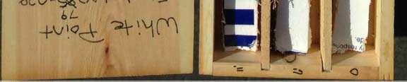
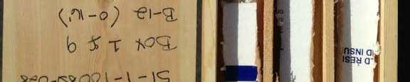
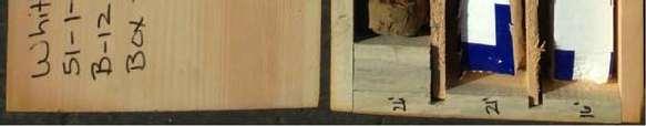
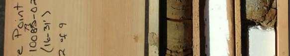
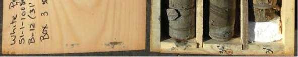
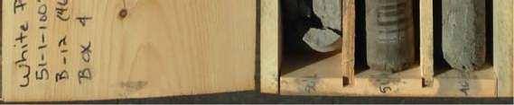
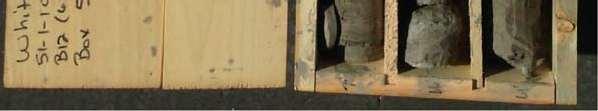
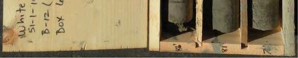
2 APPENDIX B SUBSURFACE EXPLORATIONS TABLE OF CONTENTS Page B.1. B.2. B.3. B.4. B.5. B.6. B.7. GENERAL...B-1 HEALTH AND SAFETY PLAN...B-1 DRILLING PROCEDURES...B-1 SAMPLING PROCEDURES...B-2 ENVIRONMENTAL FIELD SCREENING FOR VOLITILE ORGANIC COMPOUNDS (VOCS)...B-2 REVIEW AND CLASSIFICATION OF SAMPLES...B-3 B.6.1. Field Observations...B-3 B.6.2. Soil Classification System...B-3 B.6.3. Geologic Units and Descriptions...B-3 B.6.4. Boring Log...B-3 REFFERENCES...B-4 FIGURES B-1 Soil Classification and Log Key (3 sheets) B-2 Log of Boring B-12 (9 sheets) B-3 Core Photographs Boring B-12 (9 sheets) AB/wp/ADY B-i
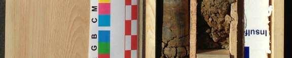
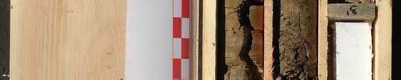
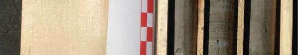
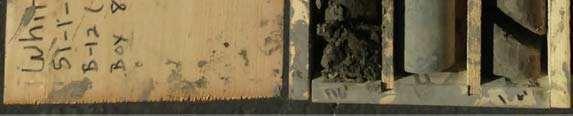
3 APPENDIX B SUBSURFACE EXPLORATIONS B.1. GENERAL Shannon & Wilson drilled one new boring (B-12) at the intersection of Paseo Del Mar and Weymouth Avenue at the location shown on Plate 1. The boring was drilled to a depth of approximately 131 feet below the existing ground surface. A description of the drilling methods and other field procedures used to perform the subsurface exploration is included in this appendix. The Soil and Rock Classification and Log Key is provided as Figure B-1. The boring log for B-12 is included as Figure B-2. Photographs of the rotary core samples are included as Figure B-3. B.2. HEALTH AND SAFETY PLAN The Health and Safety Plan used as a part of boring B-12 activities was prepared during previous fieldwork at the site, and provided in Appendix B of the Addendum Report (2012b). The plan identified known hazards at the site and possible hazards related to subsurface structures and utilities. The plan was previously submitted to City representatives for their review and approval. The field program for B-12 was completed with no reportable injuries to Shannon & Wilson personnel or subcontractors. B.3. DRILLING PROCEDURES Gregg Drilling & Testing, Inc. (Gregg) of Signal Hill, California provided and operated a trackmounted Fraste MD/XL drill rig to complete boring B-12 between April 11 and April 16, A California Certified Engineering Geologist from Shannon & Wilson supervised the field exploration program, including locating the boring, observing the exploratory drilling, collecting samples, and logging the boring. Our Field Activity Reports during the drilling are included in Appendix A. The triple-tube core barrel used in the rotary core drilling method by Gregg Drilling consists of inner and outer barrels and a split inner core tube. The outer barrel rotates while the inner barrel and the inner split tube remain stationary. This system helps protect the core from the drilling fluid (mixture of soil/rock cuttings and water) and reduces the torsional forces transmitted to the core. In addition, the split inner tube allows for detailed visual analysis of the relatively AB/wp/ADY B-1
4 undisturbed core. The system used by Gregg Drilling for this project was a HQ-3 system, where the core diameter is 2.5 inches and the borehole diameter is 3.75 inches. Following geophysical logging the hole was then reamed to a 6-inch-diameter using a tri-cone bit. During the mud-rotary drilling, bentonite drilling mud was pumped out of a mud tank at the ground surface, down the N-size (2.8-inch OD) drill rods, out through the bit at the bottom of the borehole, up the annulus of the hole between the drill rods and the borehole, and back into the mud tank. The circulating drilling mud removed the cuttings generated by the drilling process from the hole, carrying them to the surface where they were screened and removed from the circulating drilling mud. B.4. SAMPLING PROCEDURES Continuous HQ3 coring was used in boring B-12 to sample and advance through rock. The boring log is provided in this appendix. Core samples were visually described and classified in the field, then boxed for transport to our laboratory and storage facility for further examination. Our field representative observed the coring process, logged the core, and noted the bedding, Designation (RQD), which is defined as the sum of the length of core pieces in a given core run that are greater than 4 inches in length divided by the total core run length. The percent recovery and RQD are represented on the boring logs. The samples obtained from the rotary core method are assumed to be relatively undisturbed. Rock type, relative orientations of any bedding or discontinuities, and any other pertinent features were measured, recorded and noted on the log of each boring. B.5. ENVIRONMENTAL FIELD SCREENING FOR VOLITILE ORGANIC COMPOUNDS (VOCS) Soil samples were field screened by the Shannon & Wilson field representative for contamination in accordance with Guidelines. Fieldscreening methods consist of (a) visual observations, (b) photoionization detector (PID) measurements, (c) and/or olfactory observations. The PID was used to screen for the presence VOCs. Field screening did not indicate potential soil contamination. The intent of PID monitoring is to evaluate the potential presence of contamination of soil and potential exposure to VOC in the breathing zone during drilling operations. Chemical testing on samples of the drill cutting and mud was performed, prior to disposal AB/wp/ADY B-2
5 B.6. REVIEW AND CLASSIFICATION OF SAMPLES B.6.1. Field Observations The boring was observed by a Shannon & Wilson California Certified Engineering Geologist, who collected, classified, stored, and transported soil and rock samples; performed field screening; and prepared a detailed log of the exploration. In addition to examining and collecting soil samples, the field representatives also noted drill action, problems during drilling (e.g., heave, hole collapse, etc.), and other issues. B.6.2. Soil Classification System Soil classification for this project was based on ASTM D 2487, Standard Test Method for Classification of Soil for Engineering Purposes, and ASTM D 2488, Standard Recommended Practice for Description of Soils (Visual-Manual Procedure). The system is called the Unified Soil Classification System (USCS) and is summarized in Figure B-1. Rock classification was done in accordance with International Society of Rock Mechanics (Ulusay et al., 2007) methods. Figure B-1 presents a summary of the ISRM rock classification system. B.6.3. Geologic Units and Descriptions The geologic units as described in the report are used to maintain consistency when defining geology encountered in the borings throughout the project area. These geologic units are interpretive and are based on our review of existing geologic literature for the project area. The geologic unit designations for each soil layer are shown in the descriptions in the boring logs included in this appendix. B.6.4. Boring Log A boring log is a written record of the subsurface conditions encountered in the exploration. It shows the soil or rock layers (bedding) and fractures or discontinuities encountered in the exploration and the rock or USCS symbol of each layer. Other information shown in the boring logs includes groundwater level measurements, horizontal coordinates, surface elevation, and types and depths of sampling. Because a down-hole televiewer was performed, measured bedding and discontinuity attitudes are also shown on the boring log. The review and completion of the final boring logs were performed by following a Quality Assurance/Quality Control (QA/QC) process developed by Shannon & Wilson. This program includes review of the samples by an experienced geologist after initial field observations are made, cross-checks with laboratory test results, and further cross-checks with AB/wp/ADY B-3
6 developed geologic profiles. This detailed procedure is followed to assure consistency of the data presentation and to provide adequate QC for each exploration. B.7. REFERENCES ASTM International (ASTM), 2006, Annual Book of Standards-Construction, v. 4.08, soil and rock, (I): D 420 D 5611: West Conshohocken, Pa Ulusay, Resat and Hudson, J. A., eds., 2007, The complete ISRM suggested methods for rock characterization, testing and monitoring: : Ankara, Commission on Testing Methods, International Society of Rock Mechanics, 628 p. Shannon & Wilson, Inc., 2012b, Final Addendum Geotechnical Report No. 1, White Point Landslide: Report prepared by Shannon & Wilson, Inc., Glendale, Calif., W. O. E , for City of Los Angeles Geotechnical Engineering Group, Los Angeles, Calif., August, 500 p AB/wp/ADY B-4
7
8
9
10
11
12
13
14
15
16
17
18


19
20
21
22
23
24
25
26
27
Data Report for White Point Landslide Boring B-12 W.O. E Task Order Solicitation San Pedro District Los Angeles, California
 Data Report for White Point Landslide Boring B-12 W.O. E1907483 Task Order Solicitation 11-087 San Pedro District Los Angeles, California Submitted To: Mr. Christopher F. Johnson, P.E., G.E. City of Los
APPENDIX C SUBSURFACE EXPLORATIONS
 APPENDIX C SUBSURFACE EXPLORATIONS 51-1-52-021 APPENDIX C SUBSURFACE EXPLORATIONS TABLE OF CONTENTS Page C.1. C.2. C.3. C.4. C.5. C.6. GENERAL...C-1 DRILLING PROCEDURES...C-1 SAMPLING PROCEDURES...C-2
ENCE 3610 Soil Mechanics. Site Exploration and Characterisation Field Exploration Methods
 ENCE 3610 Soil Mechanics Site Exploration and Characterisation Field Exploration Methods Geotechnical Involvement in Project Phases Planning Design Alternatives Preparation of Detailed Plans Final Design
Rotary Drilling Rotary Drilling Bits
 GE 343 SUBSURFACE EXPLORATION CH 8 Rock Drilling, Testing, and Sampling Text Ch. 7. Dr. Norbert H. Maerz Missouri University of Science and Technology (573) 341-6714 norbert@mst.edu Instructional Objectives
Slope Stability Evaluation Ground Anchor Construction Area White Point Landslide San Pedro District Los Angeles, California.
 Slope Stability Evaluation Ground Anchor Construction Area White Point Landslide San Pedro District Los Angeles, California Submitted To: Mr. Gene Edwards City of Los Angeles Department of Public Works
Core Barrels. Core Barrels
 Core Barrels To collect the core of the rock drilled, a device known as the core barrel is used. Core barrel retains rock core samples from drilling operations Its length varies from 0.5 to 3 m. There
Instructional Objectives
 GE 343 SUBSURFACE EXPLORATION CH 8 Rock Drilling, Testing, and Sampling Text Ch. 7. Dr. Norbert H. Maerz Missouri University of Science and Technology (573) 341-6714 norbert@mst.edu Instructional Objectives
10. GEOTECHNICAL EXPLORATION PROGRAM
 Geotechnical site investigations should be conducted in multiple phases to obtain data for use during the planning and design of the tunnel system. Geotechnical investigations typically are performed in
TAKING THE MYSTERY OUT OF USACE S ER DRILLING IN EARTH EMBANKMENT DAMS AND LEVEES
 TAKING THE MYSTERY OUT OF USACE S ER 1110-1-1807 DRILLING IN EARTH EMBANKMENT DAMS AND LEVEES 237 237 237 217 217 217 200 200 200 80 119 27 252 174.59 1 255 255 255 0 0 0 163 163 163 131 132 122 239 65
Site investigation in rock
 Site investigation in rock masses Geotechnical Core Drilling & Logging Core Orientation Borehole Surveying Logging g Core Borehole Log Face Mapping Scanline Data Analysis Influence of Joints Orientation
B-1 BORE LOCATION PLAN. EXHIBIT Drawn By: 115G BROOKS VETERINARY CLINIC CITY BASE LANDING AND GOLIAD ROAD SAN ANTONIO, TEXAS.
 N B-1 SYMBOLS: Exploratory Boring Location Project Mngr: BORE LOCATION PLAN Project No. GK EXHIBIT Drawn By: 115G1063.02 GK Scale: Checked By: 1045 Central Parkway North, Suite 103 San Antonio, Texas 78232
SITE INVESTIGATION 1
 SITE INVESTIGATION 1 Definition The process of determining the layers of natural soil deposits that will underlie a proposed structure and their physical properties is generally referred to as site investigation.
Boreholes. Implementation. Boring. Boreholes may be excavated by one of these methods: 1. Auger Boring 2. Wash Boring 3.
 Implementation Boreholes 1. Auger Boring 2. Wash Boring 3. Rotary Drilling Boring Boreholes may be excavated by one of these methods: 4. Percussion Drilling The right choice of method depends on: Ground
The process of determining the layers of natural soil deposits that will underlie a proposed structure and their physical properties is generally
 The process of determining the layers of natural soil deposits that will underlie a proposed structure and their physical properties is generally referred to as sub surface investigation 2 1 For proper
Manual on Subsurface Investigations National Highway Institute Publication No. FHWA NHI Federal Highway Administration Washington, DC
 Manual on Subsurface Investigations National Highway Institute Publication No. FHWA NHI-01-031 Federal Highway Administration Washington, DC Geotechnical Site Characterization July 2001 by Paul W. Mayne,
Gotechnical Investigations and Sampling
 Gotechnical Investigations and Sampling Amit Prashant Indian Institute of Technology Gandhinagar Short Course on Geotechnical Investigations for Structural Engineering 12 14 October, 2017 1 Purpose of
WHITE POINT LANDSLIDE GEOTECHNICAL INVESTIGATION November 29, 2012 Status Report
 Gary Lee Moore, P.E., City Engineer Vince Jones, P.E., Deputy City Engineer WHITE POINT LANDSLIDE GEOTECHNICAL INVESTIGATION November 29, 2012 Status Report White Point Landslide Geotechnical Investigation
B-1 SURFACE ELEVATION
 5A 5B LOGGED BY El. S. Bhangoo DRILLING CONTRACTOR Pitcher Drilling DRILLING METHOD Rotary Wash BEGIN DATE 12-14-12 SAMPLER TYPE(S) AND SIZE(S) (ID) SPT, MC BOREHOLE BACKFILL AND COMPLETION COMPLETION
Underground Risk Management Course Marina Del Rey, California November, Geotechnical Data Reports. Greg Raines, PE
 Underground Risk Management Course Marina Del Rey, California November, 2018 Geotechnical Data Reports Greg Raines, PE Gregory.Raines@Stantec.com Introduction What is a Geotechnical Data Report? The GDR
Preliminary Geotechnical and Environmental Report
 ` Preliminary Geotechnical and Environmental Report (Volume 2) December 2011 THIS PAGE INTENTIONALLY LEFT BLANK VOLUME 2 Summary As part of PE phase, the following investigations were performed: Geotechnical
SLOPE STABILITY EVALUATION AND ACCEPTANCE STANDARDS
 INFORMATION BULLETIN / PUBLIC - BUILDING CODE REFERENCE NO.: LABC 7006.3, 7014.1 Effective: 01-01-2017 DOCUMENT NO.: P/BC 2017-049 Revised: 12-21-2016 Previously Issued As: P/BC 2014-049 SLOPE STABILITY
Chapter 12 Subsurface Exploration
 Page 12 1 Chapter 12 Subsurface Exploration 1. The process of identifying the layers of deposits that underlie a proposed structure and their physical characteristics is generally referred to as (a) subsurface
Attachment 3. Draft Preliminary Geotechnical Report. City of Los Angeles, Bureau of Engineering
 Attachment 3 Draft Preliminary Geotechnical Report City of Los Angeles, Bureau of Engineering Preliminary Geotechnical Report White Point Landslide San Pedro District Los Angeles, California W.O. E1907483
M E M O R A N D U M. Mr. Jonathan K. Thrasher, P.E., Mr. Ian Kinnear, P.E. (FL) PSI
 PSI") M E M O R A N D U M TO: FROM: Mr. Mark Schilling Gulf Interstate Engineering Mr. Jonathan K. Thrasher, P.E., Mr. Ian Kinnear, P.E. (FL) PSI DATE: November 11, 2014 RE: Summary of Findings Geotechnical
M E M O R A N D U M TO: FROM: Mr. Mark Schilling Gulf Interstate Engineering Mr. Jonathan K. Thrasher, P.E., Mr. Ian Kinnear, P.E. (FL) PSI DATE: November 11, 2014 RE: Summary of Findings Geotechnical
2 OVERVIEW OF SHALLOW BOREHOLE INVESTIGATIONS
 2 OVERVIEW OF SHALLOW BOREHOLE INVESTIGATIONS Preparation for MSB-2 started in April 2002. Drilling and planned field work in both MSB-2 and 4 were carried out at the same time. After completion of the
SLOPE STABILITY EVALUATION AND ACCEPTANCE STANDARDS
 INFORMATION BULLETIN / PUBLIC - BUILDING CODE REFERENCE NO.: LAMC 98.0508 Effective: 1-26-84 DOCUMENT NO. P/BC 2002-049 Revised: 11-1-02 Previously Issued As: RGA #1-84 SLOPE STABILITY EVALUATION AND ACCEPTANCE
Guidelines for Site-Specific Seismic Hazard Reports for Essential and Hazardous Facilities and Major and Special-Occupancy Structures in Oregon
 Guidelines for Site-Specific Seismic Hazard Reports for Essential and Hazardous Facilities and Major and Special-Occupancy Structures in Oregon By the Oregon Board of Geologist Examiners and the Oregon
IAEA SAFETY STANDARDS Geotechnical Aspects of Site Evaluation and Foundations in NPPs, NS-G-3.6
 IAEA SAFETY STANDARDS Geotechnical Aspects of Site Evaluation and Foundations in NPPs, NS-G-3.6 Regional Workshop on Volcanic, Seismic, and Tsunami Hazard Assessment Related to NPP Siting Activities and
Exploration Drilling Techniques
 Exploration Techniques Why do we need natural resources? average increase in demand: 5 % per year How do we find new resources? How do we find new resources? Fun! Geological methods: In my view the greatest
Ardaman & Associates, Inc. Geotechnical, Environmental and Materials Consultants
 SUBSURFACE SOIL EXPLORATION 42-INCH FORCE MAIN REPLACEMENT CHIQUITA BOULEVARD S AND SW 34 TH STREET CAPE CORAL, LEE COUNTY, FLORIDA Ardaman & Associates, Inc. Geotechnical, Environmental and Materials
Geotechnical Data Report
 Geotechnical Data Report Downtown Greenville Future Conveyance Study December 1, 2015 Terracon Project No. 86155032 Prepared for: Prepared by: Terracon Consultants, Inc. December 1, 2015 561 Mauldin Road
Pierce County Department of Planning and Land Services Development Engineering Section
 Page 1 of 7 Pierce County Department of Planning and Land Services Development Engineering Section PROJECT NAME: DATE: APPLICATION NO.: PCDE NO.: LANDSLIDE HAZARD AREA (LHA) GEOLOGICAL ASSESSMENT REPORT
IV. ENVIRONMENTAL IMPACT ANALYSIS G. GEOLOGY AND SOILS
 IV. ENVIRONMENTAL IMPACT ANALYSIS G. GEOLOGY AND SOILS The following section is a summary of the geotechnical report conducted for the proposed project. The Report of Geotechnical Investigation Proposed
Module 1 : Site Exploration and Geotechnical Investigation
 Objectives In this section you will learn the following Displacement borings Wash boring Auger boring Rotary drilling Percussion drilling Continuous sampling Boring methods of exploration The boring methods
DATA REPORT GEOTECHNICAL INVESTIGATION GALVESTON CRUISE TERMINAL 2 GALVESTON, TEXAS
 DATA REPORT GEOTECHNICAL INVESTIGATION GALVESTON CRUISE TERMINAL 2 GALVESTON, TEXAS SUBMITTED TO PORT OF GALVESTON 123 ROSENBERG AVENUE, 8TH FLOOR GALVESTON, TEXAS 77553 BY HVJ ASSOCIATES, INC. HOUSTON,
INNOVATIVE TECHNIQUES TO INVESTIGATE CONTAMINATION IN FRACTURED BEDROCK
 INNOVATIVE TECHNIQUES TO INVESTIGATE CONTAMINATION IN FRACTURED BEDROCK Abstract Christopher Gaule 1, Kenneth Goldstein 2, Grant Anderson 3 Watervliet Arsenal, located in Watervliet, New York, is the oldest
Civil Engineering, Surveying and Environmental Consulting WASP0059.ltr.JLS.Mich Ave Bridge Geotech.docx
 2365 Haggerty Road South * Canton, Michigan 48188 P: 734-397-3100 * F: 734-397-3131 * www.manniksmithgroup.com August 29, 2012 Mr. Richard Kent Washtenaw County Parks and Recreation Commission 2330 Platt
IV. ENVIRONMENTAL IMPACT ANALYSIS E. GEOLOGY/SOILS
 IV. ENVIRONMENTAL IMPACT ANALYSIS E. GEOLOGY/SOILS Except where otherwise noted, the following Section is based on the Preliminary Geotechnical Investigation, Proposed Medical Office Buildings and Mixed-Use
 Project: ITHACA-TOMPKINS REGIONAL AIRPORT EXPANSION Project Location: ITHACA, NY Project Number: 218-34 Key to Soil Symbols and Terms TERMS DESCRIBING CONSISTENCY OR CONDITION COARSE-GRAINED SOILS (major
OVERVIEW OF ER DRILLING IN EARTH EMBANKMENT DAMS AND
 OVERVIEW OF ER 1110-1-1807 DRILLING IN EARTH EMBANKMENT DAMS AND 255 255 255 237 237 237 0 0 0 217 217 217 LEVEES 163 163 163 200 200 200 131 132 122 239 65 53 80 119 27 110 135 120 Requirements and Processes
Guideline Petroleum Drilling Regulations (CNR 1150/96)
") Government of Newfoundland and Labrador Department of Natural Resources Guideline Petroleum Drilling Regulations (CNR 1150/96) Topic: Final Well Report Onshore Petroleum Exploratory Wells Ref: Section
Government of Newfoundland and Labrador Department of Natural Resources Guideline Petroleum Drilling Regulations (CNR 1150/96) Topic: Final Well Report Onshore Petroleum Exploratory Wells Ref: Section
Geotechnical Investigation Juneau Seawalk - Taku Fisheries to Miner s Wharf Juneau, Alaska DM&A Job No
 Duane Miller & Associates 5821 Arctic Boulevard, Suite A Anchorage, AK 99518-1654 (907) 644-3200 Fax 644-0507 Arctic & Geotechnical Engineering May 4, 2006 Tetra Tech/KCM, Inc. 1971 First Avenue Seattle,
Soil Sampling Results Former Truck Maintenance Garage
 Soil Sampling Results Former Truck Maintenance Garage Maine Yankee Decommissioning Project Corrective Measures Study May 2004 Prepared for: Maine Yankee 321 Old Ferry Road, Bailey Point Wiscasset, ME 04578
GEOTECHNICAL REPORT. Matanuska-Susitna Borough. Parks Highway Connections Museum Drive. Matanuska-Susitna Borough, Alaska.
 Matanuska-Susitna Borough GEOTECHNICAL REPORT Parks Highway Connections Museum Drive Matanuska-Susitna Borough, Alaska March 2, 20 Prepared By: John Thornley, PE Geotechnical Engineer 333 Arctic Blvd.,
SI Planning & Laboratory Testing for Hill-Site Development
 SI Planning & Laboratory Testing for Hill-Site Development 21 April 2009 IEM Penang Ir. Tan Yean Chin G&P Geotechnics Sdn Bhd Cameron Highlands, 1961 Genting Highland Tower 1993 Bukit Antarabangsa, 1999
Standard Test Method for Determination of the Point Load Strength Index of Rock 1
 Designation: D 5731 95 AMERICAN SOCIETY FOR TESTING AND MATERIALS 100 Barr Harbor Dr., West Conshohocken, PA 19428 Reprinted from the Annual Book of ASTM Standards. Copyright ASTM Standard Test Method
Geotechnical Engineering Report
 Geotechnical Engineering Report Turner Turnpike Widening Bridge D Bridge Crossing: South 209 th West Avenue Creek County, Oklahoma June 1, 2016 Terracon Project No. 04155197 Prepared for: Garver, LLC Tulsa,
Guideline REGULATORY REQUIREMENTS FOR FINAL WELL REPORTS ONSHORE TO OFFSHORE WELLS
 Guideline REGULATORY REQUIREMENTS FOR FINAL WELL REPORTS ONSHORE TO OFFSHORE WELLS 1. Introduction The requirement to prepare and submit a Final Well Report is specified by subsection 201(1) of the Newfoundland
DESIGN-PHASE GEOLOGIC FRAMEWORK MODELING FOR LARGE CONSTRUCTION PROJECTS
 DESIGN-PHASE GEOLOGIC FRAMEWORK MODELING FOR LARGE CONSTRUCTION PROJECTS Christine Vilardi, P.G., C.G.W.P. (vilardcl@stvinc.com, STV Inc., New York, New York) and Todd Kincaid, Ph.D. (Hazlett-Kincaid,
APPENDIX E SOILS TEST REPORTS
 Otsego County, NY Site Work Specifications APPENDIX E SOILS TEST REPORTS Blue Wing Services, Inc. July 1, 2010 Blue Wing Services May 20, 2010 Page 2 the site, was not made available to Empire at this
COMMUNITY DEVELOPMENT DEPARTMENT POLICY & PROCEDURE
 COMMUNITY DEVELOPMENT DEPARTMENT POLICY & PROCEDURE Policy No: DSP-OO3 Release Date: January 1, 2014 Effective Date: January 1, 2014 Revision Date: March 1, 2018 TITLE: The City Policy for Site Specific
Parsons APPENDIX A BORING LOGS AND DEVELOPMENT LOG
 Parsons APPENDIX A BORING LOGS AND DEVELOPMENT LOG GEOLOGIC LOG DATE STARTED: DATE COMPLETED: 08-Sep-09 08-Sep-09 LOGGER: Quin Kinnebrew WEATHER: Clear & Warm PAGE 1 OF 2 WELL NO. GMW-66 COMPANY NAME:
TECHNICAL MEMORANDUM
 TECHNICAL MEMORANDUM Geotechnical Investigation Guidelines TM 2.9.1 Prepared by: Signed document on file 14 May 09_ Brian O Neill, PE, GE Date Program Geotechnical Engineer Checked by: Signed document
Geotechnical Geotechnical Assessment
 Site Investigation Site Investigation Pile Probing Pile Probing Geotechnical Logging Geotechnical and Sampling Logging and Sampling Streetworks and Utilities Streetworks Avoidance and Utilities Avoidance
GEOLOGY AND SOILS. This chapter summarizes geologic and geotechnical aspects of the site as they relate to the Project.
 9 GEOLOGY AND SOILS INTRODUCTION This chapter summarizes geologic and geotechnical aspects of the site as they relate to the Project. This chapter utilizes information from the following reports prepared
Geotechnical Engineering Report
 Geotechnical Engineering Report Turner Turnpike Widening Bridge B Bridge Crossing: South 257 th West Avenue Creek County, Oklahoma June 1, 2016 Terracon Project No. 04155197 Prepared for: Garver, LLC Tulsa,
Converse Consultants Geotechnical Engineering, Environmental & Groundwater Science, Inspection & Testing Services
 Converse Consultants Geotechnical Engineering, Environmental & Groundwater Science, Inspection & Testing Services Ms. Rebecca Mitchell Mt. San Antonio College Facilities Planning & Management 1100 North
SUPPLEMENTARY INVESTIGATION AND LABORATORY TESTING Aggregate Resource Evaluation Proposed Bernand Quarry San Diego County, California
 October 3, 2 Mr. Mark San Agustin Project No. 28-- Home Land Investments Document No. -92 2239 Curlew Street San Diego, CA 92 SUBJECT: SUPPLEMENTARY INVESTIGATION AND LABORATORY TESTING Aggregate Resource
Prepared for: U.S. Army Corps of Engineers, Mobile District 109 St. Joseph Street, Mobile, Alabama Prepared by:
 Final Site-Specific Unexploded Ordnance Safety Plan Attachment Site Investigation at Artillery and Mortar Impact Areas South of Bains Gap Road, Parcels 138Q-X, 139Q-X, 140Q-X, 141Q-X, and 142Q-X Fort McClellan,
TABLE 1 SSFL CHEMICAL SOIL BACKGROUND STUDY DATA QUALITY OBJECTIVES
 Problem Statement: Soil chemical concentration data for selected constituents are needed from off-site chemical background reference areas (CBRAs) to establish a regulatory-compliant, publicly-reviewed,
Should you have any questions regarding this clarification, please contact the undersigned at or (925)
") October 8, 2015 Revised October 13, 2015 Contra Costa Community College District 500 Court Street Martinez, CA 94553 Attention: Ron Johnson Subject: Clarification of Grading Requirements Diablo Valley
October 8, 2015 Revised October 13, 2015 Contra Costa Community College District 500 Court Street Martinez, CA 94553 Attention: Ron Johnson Subject: Clarification of Grading Requirements Diablo Valley
Finding Large Capacity Groundwater Supplies for Irrigation
 Finding Large Capacity Groundwater Supplies for Irrigation December 14, 2012 Presented by: Michael L. Chapman, Jr., PG Irrigation Well Site Evaluation Background Investigation Identify Hydrogeologic Conditions
Bridging Subsurface Geologic Databases with Cross-Sections in GIS
 Bridging Subsurface Geologic Databases with Cross-Sections in GIS Eva E. von Thury ESRI International User Conference Padre Associates, Inc. Project Geologist / GIS Analyst June 29, 2016 Outline Introduction
Safe bearing capacity evaluation of the bridge site along Syafrubesi-Rasuwagadhi road, Central Nepal
 Bulletin of the Department of Geology Bulletin of the Department of Geology, Tribhuvan University, Kathmandu, Nepal, Vol. 12, 2009, pp. 95 100 Safe bearing capacity evaluation of the bridge site along
Amistad Dam Investigation and Oversight: Karst- Founded Dam on the USA-Mexico Border
 Amistad Dam Investigation and Oversight: Karst- Founded Dam on the USA-Mexico Border Brook Brosi, CPG, PG USACE Lisa Nowicki Perks, PG USACE Kimberly Heenan, PE AECOM US Army Corps of Engineers BUILDING
IV. ENVIRONMENTAL IMPACT ANALYSIS E. GEOLOGY AND SOILS
 IV. ENVIRONMENTAL IMPACT ANALYSIS E. GEOLOGY AND SOILS The following section is a summary of the geotechnical report conducted for the Proposed Project. The Geotechnical Engineering Investigation (the
REPORT OF SUBSURFACE EXPLORATION
 REPORT OF SUBSURFACE EXPLORATION GRAND RIVER DAM AUTHORITY HULBERT 69 KV SWITCHING STATION S. 440 Road Hulbert, Cherokee County, Oklahoma ENERCON PROJECT NO. GRDA006 MARCH 7, 2012 PREPARED FOR: C/O ENERCON
TECHNICAL MEMORANDUM
 TECHNICAL MEMORANDUM Geotechnical Investigation Guidelines TM 2.9.1 Prepared by: Signed document on file 14 May 09_ Brian O Neill, PE, GE Date Program Geotechnical Engineer Checked by: Signed document
2. Initial Summary of Preliminary Expert Opinion of Converse and Psomas Reports
 UNITED WALNUT TAXPAYERS PRELIMINARY REVIEW OF NEGATIVE GEOTECHNICAL AND GEOLOGICAL ASPECTS OF CONSTRUCTING EARTHFILL PAD FOR A SOLAR FARM ON THE WEST PARCEL - DRAFT 1. Introduction A licensed Engineering
PRELIMINARY GEOTECHNICAL REPORT. State College Redevelopment State College Borough, Centre County, Pennsylvania. CMT Laboratories File No.
 PRELIMINARY GEOTECHNICAL REPORT State College Redevelopment State College Borough, Centre County, Pennsylvania CMT Laboratories File No. 1638700 Prepared for: National Development Council One Battery Park
Ardaman & Associates, Inc. Geotechnical, Environmental and Materials Consultants
 SUBSURFACE SOIL EXPLORATION DRAINAGE IMPROVEMENTS TO THE HENDRY COUNTY, FLORIDA Ardaman & Associates, Inc. Geotechnical, Environmental and Materials Consultants OFFICES Orlando, 88 S. Orange Avenue, Orlando,
KDOT Geotechnical Manual Edition. Table of Contents
 KDOT Geotechnical Manual 2007 Edition The KDOT Geotechnical Manual is available two volumes. Both volumes are very large electronic (pdf) files which may take several minutes to download. The table of
Introduction to Oil&Gas Well Drilling
 Introduction to Oil&Gas Well Drilling Drilling Introduction to Oil&Gas Well Drilling The term drilling indicates the whole complex of operations necessary to construct wells of circular section applying
Site Investigations and Geotechnical Risk For Underground Construction Greg Raines, PE
 August 14, 2017 Site Investigations and Geotechnical Risk For Underground Construction Greg Raines, PE Gregory.Raines@Stantec.com Develop Preliminary Geologic / Geotech Conceptual Model for the Project
GEOTECHNICAL INVESTIGATION REPORT
 GEOTECHNICAL INVESTIGATION REPORT SOIL INVESTIGATION REPORT FOR STATIC TEST FACILITY FOR PROPELLANTS AT BDL, IBRAHIMPATNAM. Graphics Designers, M/s Architecture & Engineering 859, Banjara Avenue, Consultancy
The attitude he maintains in his relation to the engineer is very well stated in his own words:
 Su bsurface Soil Exploration, 53: 139 Foundation Engineering Geotechnical companies that have a history of experience in a given region usually have extensive boring logs and maps telling where the borings
Ideas to Design an in situ Diamond Drilling Core Splitter within Soft Rocks*
 Ideas to Design an in situ Diamond Drilling Core Splitter within Soft Rocks* G. M. Tetteh, J. A. Aluah, J. Ahmed and S. Alornyo Tetteh, G. M., Aluah, J. A., Ahmed, J. and Alornyo, S. (2015), Ideas to Design
Week 3 : (3HL) Coverage : Typical geotechnical problems and usual application of SI methods
 Coverage : Typical geotechnical problems and usual application of SI methods") LEARNING OUTCOMES Week 3 : (3HL) Coverage : Typical geotechnical problems and usual application of SI methods Learning Outcomes : At the end of this lecture/week, the students will be able to : 1. Discuss
LEARNING OUTCOMES Week 3 : (3HL) Coverage : Typical geotechnical problems and usual application of SI methods Learning Outcomes : At the end of this lecture/week, the students will be able to : 1. Discuss
Limited Geotechnical Engineering Evaluation Classroom Additions Albany County Campus Laramie, Wyoming
 Limited Geotechnical Engineering Evaluation Classroom Additions Albany County Campus 2300 Missile Drive, Cheyenne, Wyoming 82001 Phone 307-635-0222 www.stratageotech.com Limited Geotechnical Engineering
3.0 SUMMARY OF FINDINGS
 AECOM 500 W Jefferson St. Suite 1600 Louisville, KY 40202 www.aecom.com 502-569-2301 tel 502-569-2304 fax October 17, 2018 Big Rivers Electric Corporation Sebree Generating Station 9000 Highway 2096 Robards,
 GEOLOGY Local Geology Local geologic mapping shows the site underlain by Goble Volcanics consisting of basalt and andesite, with basalt breccia, volcanic conglomerate, and interbedded siltstone and pyroclastics
GEOTECHNICAL TESTING OF SEDIMENT
 ApPENDIX El. GEOTECHNICAL TESTING OF SEDIMENT (Modified from Exponent, 20Q1c) E.I Introduction This appendix presents information regarding geotechnical testing performed in 2000 on sediments in Onondaga
Preliminary Geotechnical Investigation Cadiz / Trigg County I-24 Business Park. Cadiz, Kentucky
 Environmental & Geoscience, LLC 834 Madisonville Road Hopkinsville, KY 440 70.44.000 FAX 70.44.8300 www.wedrill.com A member of Trinity Energy & Infrastructure Group, LLC Preliminary Geotechnical Investigation
GZA GeoEnvironmental, Inc.
 GZA BORING NO.: GZ-1 SHEET: 1 of 1 PROJECT NO: 9.223. Drilling Co.: Geologic Type of Rig: Skid Boring Location: See Plan H. Datum: See Plan Rig Model: Mudline : Foreman: Ray Eastwood CME -.8 Final Boring
GEOTECHNICAL ENGINEERING II. Subject Code : 06CV64 Internal Assessment Marks : 25 PART A UNIT 1
 GEOTECHNICAL ENGINEERING II Subject Code : 06CV64 Internal Assessment Marks : 25 PART A UNIT 1 1. SUBSURFACE EXPLORATION 1.1 Importance, Exploration Program 1.2 Methods of exploration, Boring, Sounding
Exploration, Drilling & Production
 Nontechnical Guide to PETMOLEUM Geology, Exploration, Drilling & Production Third Edition Norman J. Hyne, Ph.D. Contents Preface *i Introduction 1 The Nature of Gas and Oil 1 Petroleum 1 The Chemistry
APPENDIX C. Borehole Data
 APPENDIX C Borehole Data MAJOR DIVISIONS SOIL CLASSIFICATION CHART SYMBOLS GRAPH LETTER TYPICAL DESCRIPTIONS ADDITIONAL MATERIAL
Field Geologists' Manual. AuslfTlfT) Monograph 9 FIFTH EDITION THG MINERALS INSTITUTE. Published by:
 Monograph 9 FIFTH EDITION THG MINERALS INSTITUTE. Published by:") Field Geologists' Manual FIFTH EDITION Monograph 9 AuslfTlfT) THG MINERALS INSTITUTE Published by: THE AUSTRALASIAN INSTITUTE OF MINING AND METALLURGY Ground Floor, 204 Lygon Street, Carlton Victoria 3053
Field Geologists' Manual FIFTH EDITION Monograph 9 AuslfTlfT) THG MINERALS INSTITUTE Published by: THE AUSTRALASIAN INSTITUTE OF MINING AND METALLURGY Ground Floor, 204 Lygon Street, Carlton Victoria 3053
SCOPE OF INVESTIGATION Simple visual examination of soil at the surface or from shallow test pits. Detailed study of soil and groundwater to a
 Lecture-5 Soil Exploration Dr. Attaullah Shah 1 Today s Lecture Purpose of Soil Exploration Different methods 1. Test trenches and Pits 2. Auger and Wash Boring 3. Rotary Drilling 4. Geophysical Methods
Report of Preliminary Geotechnical Exploration. CSO-012 Sewer Separation Cincinnati, Hamilton County, Ohio. February, 2011
 11242843_GeoTech_Preliminary - Feburary 2011_1/40 Report of Preliminary Geotechnical Exploration CSO-012 Sewer Separation Cincinnati, Hamilton County, Ohio February, 2011 11242843_GeoTech_Preliminary -
SIXTH SCHEDULE REPUBLIC OF SOUTH SUDAN MINISTRY OF PETROLEUM, MINING THE MINING (MINERAL TITLE) REGULATIONS 2015
 REGULATIONS 2015") SIXTH SCHEDULE REPUBLIC OF SOUTH SUDAN MINISTRY OF PETROLEUM, MINING THE MINING ACT, 2012 THE MINING (MINERAL TITLE) REGULATIONS 2015 Guidelines should be prepared by the Directorate of Mineral Development
SIXTH SCHEDULE REPUBLIC OF SOUTH SUDAN MINISTRY OF PETROLEUM, MINING THE MINING ACT, 2012 THE MINING (MINERAL TITLE) REGULATIONS 2015 Guidelines should be prepared by the Directorate of Mineral Development
Geologging Imagery, Applications and Geological Interpretation. Shea Altadonna 1, Jim Fulton 2, E.I.T.
 Geologging Imagery, Applications and Geological Interpretation Shea Altadonna 1, Jim Fulton 2, E.I.T. 1 Geologist, Advanced Construction Techniques Inc. 1000 N. West St. Ste 1200, Wilmington, DE 19801;
Report of Preliminary Geotechnical Investigation for Ponds
 Florida Department of TRANSPORTATION Report of Preliminary Geotechnical Investigation for Ponds Malabar Road (SR 514) PD&E Study From East of Babcock Street (SR 507) to US 1 Brevard County, Florida FPID:
AVON DAM MONITORING BOREHOLES REPORT
 AVON DAM MONITORING BOREHOLES REPORT September 2015 Melinda Smart Supervisor Brownfields Exploration Energy and Engineering S2313 AND S2314 MONITORING BOREHOLES Avon Dam Hole 1 (S2313) and Avon Dam Hole
Drillworks. DecisionSpace Geomechanics DATA SHEET
 DATA SHEET Drillworks overview DecisionSpace Geomechanics Key features Pre-drill, real-time, and post-drill analyses are all easily performed in one application using the latest data from across the field
SITE CHARACTERIZATION
 SITE CHARACTERIZATION Part 2. Intrusive Investigation Technologies Tyler E. Gass, CPG Tetra Tech, Inc. Louisville, CO SITE CHARACTERIZATION INTRUSIVE TECHNOLOGIES Defining the Objectives of the Investigation
 Photo 1 - Southerly view across 2700 parking lot toward existing building. Multi-residential building borders western side of property in upper right of view. Photo 2 - Southerly view across 2750 parking
Optical and Acoustic Televiewer Borehole Logging Improved Oriented Core Logging Techniques
 Optical and Acoustic Televiewer Borehole Logging Improved Oriented Core Logging Techniques Tom Eliassen, VTrans; Dorothy Richter, Hager-Richter Geoscience; Heather Crow, Peter Ingraham & Trevor Carter,
An Introduction to Field Explorations for Foundations
 An Introduction to Field Explorations for Foundations J. Paul Guyer, P.E., R.A. Paul Guyer is a registered mechanical engineer, civil engineer, fire protection engineer and architect with over 35 years
GEOTECHNICAL INVESTIGATION REPORT INFRASTRUCTURE PVT LTD
 GEOTECHNICAL INVESTIGATION REPORT Client : TAEIN CONSTRUCTION & INFRASTRUCTURE PVT LTD Office address : Flat No.104, A -Wing,1st floor,gloria Park, Paranjape Scheme, Bavdhan Khurd, Chandni Chowk, Pune