2 OVERVIEW OF SHALLOW BOREHOLE INVESTIGATIONS
|
|
|
- Melina Hodges
- 5 years ago
- Views:
Transcription
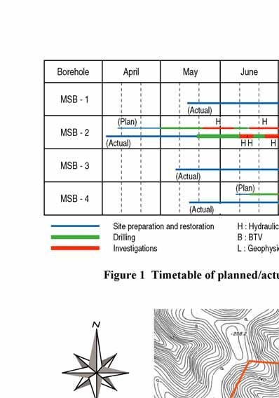
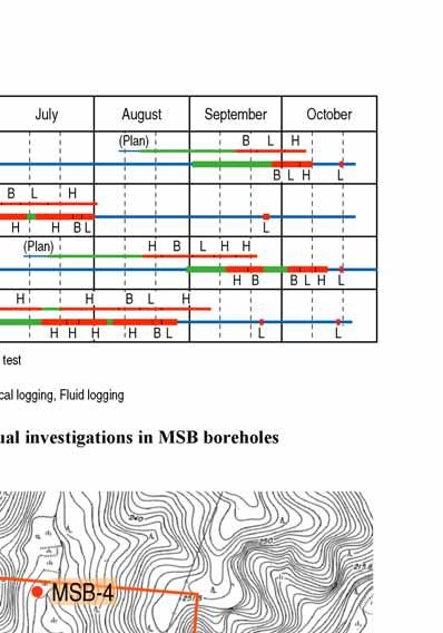
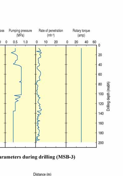
1 2 OVERVIEW OF SHALLOW BOREHOLE INVESTIGATIONS Preparation for MSB-2 started in April Drilling and planned field work in both MSB-2 and 4 were carried out at the same time. After completion of the field work in MSB-2 and 4, drilling and planned field work in both MSB-1 and 3 were carried out. All field work and site restorations were finished on schedule by the end of October Four sets of the MP System TM were installed in all boreholes by December In each borehole, the entire drilled sections include the sedimentary rocks of the Mizunami Group and the upper part of the Toki Granite. Geological, hydrogeological and geochemical investigations were carried out according to the Working Programme [2], as shown in Figures 1 to 6. The following subsections (2.1 to 2.7) provide an overview of the Shallow Borehole Investigations in each field. 3


2


3
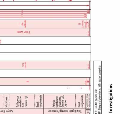
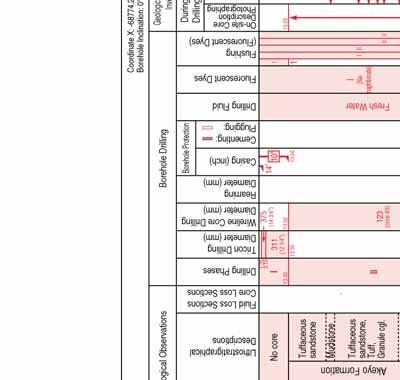
4 I I 6 Borehole Drilling no1:dpp no2:dpp no3:dpp/ws no4:spp/ws no5:dpp/ws Mizunami Group Akeyo Formation Toki Lignite-bearing Formation Toki Granite II III Stratigraphical Units Lithostratigraphical Column Drilling Phases Wireline Core Drilling Diameter (mm) Reaming Diameter (mm) Overview of MSB-2 Investigations 123 (core 83) Coordinate X: , Y: , Z: Borehole Inclination: 0 from vertical 13 August 2003 / N.Kumazaki Geological / Geophysical Investigations During Drilling After Drilling Geophysical Logging BTV Hydrogeological / Hydrochemical Investigations Hydraulic Tests, Water Sampling* Drilling During Drilling After Fresh Water (14") 10" " (12 1/4") I (Nanaphtionate) II (Uranine) 1 I II 23 II II 45 Fluid Loss Sections Core Loss Sections Casing Drilling Diameter (mm) Casing (inch) Cementing: Plugging: Drilling Fluid Fluorescent Dyes Flushing (Fluorescent Dyes) On-site Core Description Photographing Core Sampling Fluid Logging Borehole Protection *Hydraulic Tests / Water Sampling = s: Single packer test, d: Double packer test PP: Pumping Test, SP: Slug and pulse tests, WS: Water sampling Figure 4 Overview of MSB-2 Investigations Toki Granite Drilling Depth (mabh) Lithostratigraphical Column Elevation (masl) Geological Predictions Geological Observations Tuffaceous sandstone Basal conglomerate Arkosic sandsotne, Mudstone, Granule cgl., Lignite Basal conglomerate Toki Lignite-bearing Formation Akeyo Formation No core Mudstone Tuffaceous sandstone, Tuff weathered zone medium-grained biotite granite Lithostratigraphical Descriptions


5


6
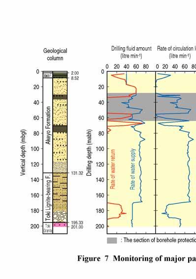
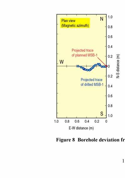
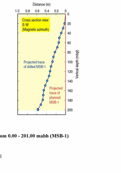
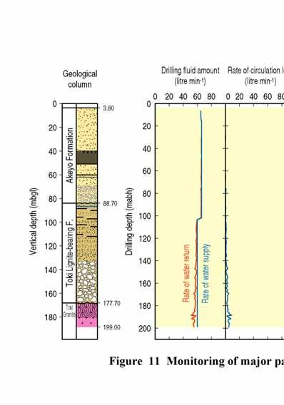
7 2.1 Borehole Drilling Aims - Full core recovery for geological, hydrogeological, hydrochemical and geochemical investigations. - To provide suitable locations for downhole investigations such as hydraulic tests, groundwater sampling and borehole logging Work performed The four MSB boreholes were drilled with two rigs. Initially, MSB-2 and 4 were drilled simultaneously, and then MSB-1 and 3 were drilled. As planned the original working programme, each borehole was drilled in three phases, phase I from surficial material to bedrock, phase II to above or immediately below the unconformity between sedimentary rocks and granite, and phase III to below the bottom of the weathered granite (Figures 3, 4, 5 and 6). Casing and cementing: After the soil and friable top of the Mizunami Group were drilled with either tricone bit or casing drilling from the surface to depths ranging from 2.00 to 8.15 mabh (metres along borehole), 14 inch (355 mm) casing pipes were installed and fixed by full hole cementing. PQ wireline core drilling was then performed from the bottom of the 14 inch casing to a depth of to mabh. In MSB-4, tricone bit drilling was used because the need for core was low. After the boreholes were reamed to a diameter of 12 1/4 inch (311 mm), 10 inch (254 mm) casing pipes were installed and fixed by full hole cementing. Summary of drilling and casing installations in each borehole is shown in Table 1. Table 1 Summary of drilling and casing installations Borehole MSB-1 MSB-2 MSB-3 MSB m m m m Coordinates* m m m m m m m m Drilling length m m m 99.0 m Core recovery 98.6 % 96.8 % 97.3 % 99.4 % 14 -STPG** 2.00 mabh 8.15 mabh 3.41 mabh 3.10 mabh Casing 10 -SUS*** mabh mabh mabh mabh Temporary 5 -SUS*** mabh - Water level after drilling mabh mabh 14.8 mabh 8.1 mabh *Coordinates: World Geodetic System **STPG: carbon-steel casing ***SUS: stainless-steel casing Coring: PQ wireline core drilling was performed from the bottom of the 14 inch casing to the final depth in each borehole. A triple-barrel corer with an acrylic innermost tube was employed to ensure full core recovery. For all PQ drilling, the borehole diameter was 123 mm and the core diameter was 83 mm. MSB-1, 2 and 4 are vertical, while MSB-3 is an inclined hole, about 20 degrees from vertical, oriented to intersect the NNW fault in the sedimentary rocks. 9
8 Drilling/flushing fluid: Fresh water was used for all drilling and flushing operations. The fresh water was tagged with different fluorescent dyes, depending on the rock being drilled, to allow identification of drilling fluid during the hydrochemical investigations. Drilling fluid (I), fresh water tagged with Na-naphtionate, was used only in the sedimentary rocks and drilling fluid (II), fresh water tagged with uranine, was used in the final drilling phase into the upper part of the granite. The concentration of fluorescent dyes was kept as constant as possible during drilling. Monitoring: Drilling data such as drilling rate, bit revolution, bit load, torque, pumping pressure, rate of water supply and return and any fluid volumes lost or gained were continuously monitored to complement the geological and hydrogeological investigations. A single shot hole deviation survey and calliper logging were performed after every 30 m of drilling and/or at geological boundaries because borehole enlargement due to circulation fluid erosion was expected in the sedimentary rocks based on prior experience in drilling other boreholes. The principal drilling parameters monitored and the result of borehole deviation in each borehole are presented in Figures 7 to 14. Borehole protection: The occurrence of fluid loss and/or borehole collapse and the remedial action taken in each borehole is presented in Table 2. In MSB-1, 100 % drilling fluid loss occurred in the interval from 28 to 64 mabh. It was decided that plugging by cementing as well as with cellulose (LCM) was needed in this interval because hydraulic testing and long term monitoring would be difficult to perform because of the low hydraulic head. Although 100 % fluid loss occurred again below 67 mabh in MSB-1, drilling continued without borehole protection because there was insufficient time to identify the outflow point(s) and perform hydraulic tests. In MSB-3, borehole collapse occurred at the bottom of the basal conglomerate of the Akeyo Formation and at the NNW fault. Dredging and flushing by reverse circulation (from outside to inside of PQ rods) during drilling was performed often to prevent sludge accumulation and borehole collapse. Table 2 Occurrence of fluid loss and borehole collapse and the remedial action in each borehole Borehole MSB-1 MSB-2 MSB-3 MSB-4 Several percent loss i) 100 % loss (between top Several percent Loss of drilling (28~64 mabh) of basal loss fluid ii) 100 % loss conglomerate layer (in granite) (67~199 mabh) in Akeyo F. and None. bottom of borehole) Remedial action for loss of drilling fluid Borehole collapse Remedial action for borehole collapse Fluid loss section filled with LCM and cemented. Drilling continued. Drilling and investigation continued. Drilling and investigation continued. None. None. None. 91~102 mabh None. None. None. Dredging and flushing carried out. None. 10

9

10

11
12
13 2.1.3 Results - Drilling was successfully performed through the weathered granite in all boreholes, as planned in the original working programme. - In MSB-1, 100 % drilling fluid loss occurred in the interval from 28 to 64 mabh. Plugging with both cellulose (LCM) and cementing was carried out seven times in the interval. Although 100 % fluid loss occurred below 67 mabh, drilling continued to the bottom of the weathered granite without any plugging work. - The average rates of core recovery through the sedimentary rocks and the granite were 98.6 %, 96.8 %, 97.3 % and 99.4 % in MSB-1, 2, 3 and 4, respectively. Also, 100 % core recovery was achieved in the fault zone (87.7 to 92.2 mabh) in MSB-3. However, some cases of reduced core recovery occurred. For example, in the two intervals a few meters thick in the basal conglomerate layer of the Toki Lignite-bearing Formation in MSB-1 and 3, core recovery dropped to 55.3 % and 54.0 %, respectively. This is presumed to be because drilling fluid flushed out unconsolidated matrix in the conglomerate Evaluations - The use of a triple-barrel coring technique with an acrylic innermost tube as in the previous MIU-4 investigation resulted in both excellent core recovery and high quality core for geological, hydrogeological, hydrochemical and geochemical investigations. - The monitoring of drilling data, keeping fluorescent dye concentrations constant in the drilling fluid, periodic calliper logging during drilling and the appropriate borehole protection measures provided suitable locations for both installation of long term monitoring equipment and the downhole investigations such as hydraulic testing, and groundwater sampling Lessons learned - Periodic calliper logging during drilling should be carried out in soft sedimentary rocks such as the Mizunami Group, because fluid circulation may easily enlarge borehole diameter; this knowledge is important for follow up testing and surveys. - If necessary, PQ rods can be used as casing to the depth of significant borehole collapse in order to continue with a downsized drilling specification using, for example, HQ drilling. This will allow completion of any downhole investigations such as BTV and hydraulic tests. - Employment of a solids control system should be considered in future investigations to prevent sludge formation on borehole walls and its accumulation at the bottom of a borehole. - Further modification of drilling methods, such as using a percussion coring method without drilling fluid, to achieve full core recovery in the conglomerate layers and the weathered granite, in which lower core recovery occurred. 15
Working Program for MIZ-1 Borehole Investigations
 Working Program for MIZ-1 Borehole Investigations Katsushi Nakano, Kenji Amano, Shinji Takeuchi, Koki Ikeda, Hiromitsu Saegusa, Katsuhiro Hama, Naoki Kumazaki, Teruki Iwatsuki, Satoshi Yabuuchi and Toshinori
Rotary Drilling Rotary Drilling Bits
 GE 343 SUBSURFACE EXPLORATION CH 8 Rock Drilling, Testing, and Sampling Text Ch. 7. Dr. Norbert H. Maerz Missouri University of Science and Technology (573) 341-6714 norbert@mst.edu Instructional Objectives
Instructional Objectives
 GE 343 SUBSURFACE EXPLORATION CH 8 Rock Drilling, Testing, and Sampling Text Ch. 7. Dr. Norbert H. Maerz Missouri University of Science and Technology (573) 341-6714 norbert@mst.edu Instructional Objectives
PART I Hot Dry Rock Geothermal Energy: History and Potential of the Newest and Largest Renewable Energy Resource
 Contents PART I Hot Dry Rock Geothermal Energy: History and Potential of the Newest and Largest Renewable Energy Resource Chapter 1 Serendipity A Brief History of Events Leading to the Hot Dry Rock Geothermal
10. GEOTECHNICAL EXPLORATION PROGRAM
 Geotechnical site investigations should be conducted in multiple phases to obtain data for use during the planning and design of the tunnel system. Geotechnical investigations typically are performed in
Site investigation in rock
 Site investigation in rock masses Geotechnical Core Drilling & Logging Core Orientation Borehole Surveying Logging g Core Borehole Log Face Mapping Scanline Data Analysis Influence of Joints Orientation
Gotechnical Investigations and Sampling
 Gotechnical Investigations and Sampling Amit Prashant Indian Institute of Technology Gandhinagar Short Course on Geotechnical Investigations for Structural Engineering 12 14 October, 2017 1 Purpose of
Kentucky Geological Survey Marvin Blan #1 Hancock County, Kentucky Geologic Review. J. Richard Bowersox David A. Williams Kentucky Geological Survey
 Kentucky Geological Survey Marvin Blan #1 Hancock County, Kentucky Geologic Review J. Richard Bowersox David A. Williams Kentucky Geological Survey KYCCS Western Kentucky Project Review Lexington, Kentucky
Exploration Drilling Techniques
 Exploration Techniques Why do we need natural resources? average increase in demand: 5 % per year How do we find new resources? How do we find new resources? Fun! Geological methods: In my view the greatest
APPENDIX B SUBSURFACE EXPLORATIONS
 APPENDIX B SUBSURFACE EXPLORATIONS 51-1-10079-028 APPENDIX B SUBSURFACE EXPLORATIONS TABLE OF CONTENTS Page B.1. B.2. B.3. B.4. B.5. B.6. B.7. GENERAL...B-1 HEALTH AND SAFETY PLAN...B-1 DRILLING PROCEDURES...B-1
Core Barrels. Core Barrels
 Core Barrels To collect the core of the rock drilled, a device known as the core barrel is used. Core barrel retains rock core samples from drilling operations Its length varies from 0.5 to 3 m. There
The Geology and Hydrogeology of the Spyhill Area
 The Geology and Hydrogeology of the Spyhill Area Clare North (WorleyParsons Komex) and Martin Ortiz (The City of Calgary) 2-Jul-08 Outline Background Site Location Existing Information New Work Geology
WM2016 Conference, March 6 10, 2016, Phoenix, Arizona, USA
 Directional Drilling Technology for HLW Disposal - Outline of System and its Application 16078 Kenzo KIHO 1, Kimio MIYAKAWA 1, Takayuki SUNAGA 2 and Kazunori HASE 2 1 Central Research Institute of Electric
How to Interpret Mining Company Drill Reports & Announcements
 How to Interpret Mining Company Drill Reports & Announcements A Simple Guide amscot Stockbroking Pty Ltd A division of State One Stockbroking Ltd (AFSL 247 100) Disclaimer: All information in this document
Western Kentucky CO 2 Storage Test
 Western Kentucky CO 2 Storage Test Principal Investigators: Rick Bowersox - Lexington Dave Williams - Henderson KGS First Friday Seminar Lexington, Kentucky March 4, 2011 The project proceeded in two phases:
Exploration, Drilling & Production
 Nontechnical Guide to PETMOLEUM Geology, Exploration, Drilling & Production Third Edition Norman J. Hyne, Ph.D. Contents Preface *i Introduction 1 The Nature of Gas and Oil 1 Petroleum 1 The Chemistry
Finding Large Capacity Groundwater Supplies for Irrigation
 Finding Large Capacity Groundwater Supplies for Irrigation December 14, 2012 Presented by: Michael L. Chapman, Jr., PG Irrigation Well Site Evaluation Background Investigation Identify Hydrogeologic Conditions
Sellafield (Nirex), Wellengerg (Nagra), Äspö HRL (SKB) and Yucca Mountain (USGS, USDOE) (18).
, Wellengerg (Nagra), Äspö HRL (SKB) and Yucca Mountain (USGS, USDOE) (18).") Sellafield (irex), Wellengerg (agra), Äspö HRL (SKB) and Yucca Mountain (USGS, USDOE) (18). Minimum tension theory based on spline interpolation is one of the functions of EarthVision. It is applied to
Sellafield (irex), Wellengerg (agra), Äspö HRL (SKB) and Yucca Mountain (USGS, USDOE) (18). Minimum tension theory based on spline interpolation is one of the functions of EarthVision. It is applied to
Module 1 : Site Exploration and Geotechnical Investigation
 Objectives In this section you will learn the following Displacement borings Wash boring Auger boring Rotary drilling Percussion drilling Continuous sampling Boring methods of exploration The boring methods
Chapter 12 Subsurface Exploration
 Page 12 1 Chapter 12 Subsurface Exploration 1. The process of identifying the layers of deposits that underlie a proposed structure and their physical characteristics is generally referred to as (a) subsurface
David de Courcy-Bower and Samuel Mohr
 Applicability and Limitations of LNAPL Transmissivity as a Metric within Bedrock Formations Insert then choose Picture select your picture. Right click your picture and Send to back. David de Courcy-Bower
Lima Project: Seismic Refraction and Resistivity Survey. Alten du Plessis Global Geophysical
 Lima Project: Seismic Refraction and Resistivity Survey Alten du Plessis Global Geophysical Report no 0706/2006 18 December 2006 Lima Project: Seismic Refraction and Resistivity Survey by Alten du Plessis
Deep Exploration Technologies Coiled Tubing Drilling
 Deep Exploration Technologies Coiled Tubing Drilling Program 1 Leader: Soren Soe Drilling DEEPCORE DRILLING PLUS WORKSHOP IP and Role of Service Providers c er m IP Utilization m Co ise ial R&D Providers
Horizontal Directional Drilling: An Approach to Design and Construction. Presenter: John Briand, PE Co-Author: Danielle Neamtu, PE
 Horizontal Directional Drilling: An Approach to Design and Construction Presenter: John Briand, PE Co-Author: Danielle Neamtu, PE Presentation Outline General HDD overview Conceptual-level evaluation Detailed
Mizunami Underground Research Laboratory Project - Achievment during Phase I/II and Important Issues for Phase III - Katsuhiro Hama Tono Geoscience Ce
 Mizunami Underground Research Laboratory Project - Achievment during Phase I/II and Important Issues for Phase III - Katsuhiro Hama Tono Geoscience Center Japan Atomic Energy Agency 1-64, Yamanouchi, Akiyo-cho,
Introduction to Oil&Gas Well Drilling
 Introduction to Oil&Gas Well Drilling Drilling Introduction to Oil&Gas Well Drilling The term drilling indicates the whole complex of operations necessary to construct wells of circular section applying
SITE INVESTIGATION 1
 SITE INVESTIGATION 1 Definition The process of determining the layers of natural soil deposits that will underlie a proposed structure and their physical properties is generally referred to as site investigation.
Bedrock Characterization Mottolo Pig Farm Superfund Site
 Bedrock Characterization Mottolo Pig Farm Superfund Site Andrew Drew Hoffman, PE NH Department of Environmental Services andrew.hoffman@des.nh.gov 603.271.6778 1 Acknowledgments GZA GeoEnvironmental (lead
Pressure Grouting of Fractured Bedrock to Control Acid Mine Drainage
 WATER RESOURCES AT RISK May 14-18, 1995 Denver American Institute of Hydrology Pressure Grouting of Fractured Bedrock to Control Acid Mine Drainage S. A. Effner, G. D. Vandersluis, and V. Straskraba Hydro-Geo
Underground Risk Management Course Marina Del Rey, California November, Geotechnical Data Reports. Greg Raines, PE
 Underground Risk Management Course Marina Del Rey, California November, 2018 Geotechnical Data Reports Greg Raines, PE Gregory.Raines@Stantec.com Introduction What is a Geotechnical Data Report? The GDR
The process of determining the layers of natural soil deposits that will underlie a proposed structure and their physical properties is generally
 The process of determining the layers of natural soil deposits that will underlie a proposed structure and their physical properties is generally referred to as sub surface investigation 2 1 For proper
Geotechnical Geotechnical Assessment
 Site Investigation Site Investigation Pile Probing Pile Probing Geotechnical Logging Geotechnical and Sampling Logging and Sampling Streetworks and Utilities Streetworks Avoidance and Utilities Avoidance
Drilling a geothermal well into a deep sedimentary geothermal reservoir conclusions from case study Gross Schoenebeck
 Drilling a geothermal well into a deep sedimentary geothermal reservoir conclusions from case study Gross Schoenebeck Wulf Brandt & Geothermics Group GeoForschungsZentrum Potsdam In situ Geothermal Laboratory
Guideline REGULATORY REQUIREMENTS FOR FINAL WELL REPORTS ONSHORE TO OFFSHORE WELLS
 Guideline REGULATORY REQUIREMENTS FOR FINAL WELL REPORTS ONSHORE TO OFFSHORE WELLS 1. Introduction The requirement to prepare and submit a Final Well Report is specified by subsection 201(1) of the Newfoundland
Hydraulic and Water-Quality Characterization of Fractured-Rock Aquifers Using Borehole Geophysics
 Hydraulic and Water-Quality Characterization of Fractured-Rock Aquifers Using Borehole Geophysics John H. Williams Office of Ground Water Troy, New York Flow in Open Borehole Runkel and others (2003) Ambient
ENCE 3610 Soil Mechanics. Site Exploration and Characterisation Field Exploration Methods
 ENCE 3610 Soil Mechanics Site Exploration and Characterisation Field Exploration Methods Geotechnical Involvement in Project Phases Planning Design Alternatives Preparation of Detailed Plans Final Design
Appendix J. Geological Investigation
 Appendix J Geological Investigation Appendix J Geological Environment Table of Contents Page 1 INTRODUCTION...J-1 1.1 Purpose of the Investigation...J-1 1.2 Scope of the Investigation...J-1 2 METHODO OF
2 Overview of the geoscientific research in the MIU Project
 2 Overview of the geoscientific research in the MIU Project The MIU Project is located at the Shobasama Site in Akeyo-cho, Mizunami City, Gifu Prefecture. The geoscientific research carried out for the
Assessing the Tier 2 Trigger for Fractured Sedimentary Bedrock Sites
 Assessing the Tier 2 Trigger for Fractured Sedimentary Bedrock Sites Ken Lyon, Jennifer Arnold, Louise Burden Advisian WorleyParsons Group RemTech 2015, October 16, Banff, AB INTRODUCTION High level look
Petrophysical Data Acquisition Basics. Coring Operations Basics
 Petrophysical Data Acquisition Basics Coring Operations Basics Learning Objectives By the end of this lesson, you will be able to: Understand why cores are justified and who needs core data Identify which
Amistad Dam Investigation and Oversight: Karst- Founded Dam on the USA-Mexico Border
 Amistad Dam Investigation and Oversight: Karst- Founded Dam on the USA-Mexico Border Brook Brosi, CPG, PG USACE Lisa Nowicki Perks, PG USACE Kimberly Heenan, PE AECOM US Army Corps of Engineers BUILDING
Coating Requirements for Pipelines Installed by Horizontal Directional Drilling John D. Hair, P.E.*
 Coating Requirements for Pipelines Installed by Horizontal Directional Drilling John D. Hair, P.E.* *President, J. D. Hair & Associates, Inc., 2121 South Columbia Avenue, Suite 101, Tulsa, OK 74114-3502;
Fundamentals Of Petroleum Engineering FORMATION EVALUATION
 Fundamentals Of Petroleum Engineering FORMATION EVALUATION Mohd Fauzi Hamid Wan Rosli Wan Sulaiman Department of Petroleum Engineering Faculty of Petroleum & Renewable Engineering Universiti Technologi
Boreholes. Implementation. Boring. Boreholes may be excavated by one of these methods: 1. Auger Boring 2. Wash Boring 3.
 Implementation Boreholes 1. Auger Boring 2. Wash Boring 3. Rotary Drilling Boring Boreholes may be excavated by one of these methods: 4. Percussion Drilling The right choice of method depends on: Ground
HISTORY OF DRILLING OPERATIONS IN THE KIRISHIMA GEOTHERMAL FIELD
 HISTORY OF DRILLING OPERATIONS IN THE KIRISHIMA GEOTHERMAL FIELD Ken Soda Nittetsu Kagoshima Geothermal 1468-10 Manzen-area-aza-Ginyu, Makizono-cho, Aira-Gun, Kagoshima 899-66 Japan Key Words: geothermal
IAEA SAFETY STANDARDS Geotechnical Aspects of Site Evaluation and Foundations in NPPs, NS-G-3.6
 IAEA SAFETY STANDARDS Geotechnical Aspects of Site Evaluation and Foundations in NPPs, NS-G-3.6 Regional Workshop on Volcanic, Seismic, and Tsunami Hazard Assessment Related to NPP Siting Activities and
Well Construction and Cementing Practices in Shale and Salt Water Disposal Wells
 Well Construction and Cementing Practices in Shale and Salt Water Disposal Wells 2017 Shale Network Workshop Roger Myers, President RRM Completions, LLC 1 Agenda Well Construction Importance and Examples
The San Andreas Fault Observatory at Depth: Recent Site Characterization Studies and the 2.2-Km-Deep Pilot Hole
 The San Andreas Fault Observatory at Depth: Recent Site Characterization Studies and the 2.2-Km-Deep Pilot Hole Steve Hickman and Bill Ellsworth (USGS) Mark Zoback (Stanford University) and the Pre-EarthScope
Engineering in Support of Transformative Science
 Engineering in Support of Transformative Science Scientific Ocean Drilling of Mid-Ocean Ridge and Ridge-Flank Setting Workshop August 27, 2009 Austin, Texas Greg Myers IODP-MI Outline o Main engineering
FACTSHEET. Types of drilling in mining
 FACTSHEET Types of drilling in mining Drilling activities to raw materials achievement Scope (conceptual model & main characteristics) Drilling activities at mine sites are very diverse and are used for
Practical Application of Directional Drilling at Takigami Geothermal Field
 Proceedings World Geothermal Congress 2005 Antalya, Turkey, 24-29 April 2005 Practical Application of Directional Drilling at Takigami Geothermal Field Hisashi Jotaki 1 and Keisuke Ushijima 2 1 Idemitsu
HOW. HOW vehicle mounted units portable units also available. HOW, WHEN & WHY to Geophysically Log in S.I.?
 HOW, WHEN & WHY to Geophysically Log in S.I.? by Kim Beesley HOW HOW vehicle mounted units portable units also available Access to borehole Depth of borehole sump / rat -hole? 1 HOW? - subject to borehole
SI Planning & Laboratory Testing for Hill-Site Development
 SI Planning & Laboratory Testing for Hill-Site Development 21 April 2009 IEM Penang Ir. Tan Yean Chin G&P Geotechnics Sdn Bhd Cameron Highlands, 1961 Genting Highland Tower 1993 Bukit Antarabangsa, 1999
Initial Borehole Drilling and Testing in or Near Ignace
 JUNE 2016 PRELIMINARY ASSESSMENT OF POTENTIAL SUITABILITY Initial Borehole Drilling and Testing in or Near Ignace DRAFT FOR DISCUSSION WITH COMMUNITIES In 2010, the Nuclear Waste Management Organization
Horizontal Drilling Pilot In a Shallow Heavy Oil Reservoir in Northwestern Romania. Authors: John Lavelle, Amin Yaghoobi
 Horizontal Drilling Pilot In a Shallow Heavy Oil Reservoir in Northwestern Romania Authors: John Lavelle, Amin Yaghoobi About Suplac Oil Field Discovered 1958 Oil Density 960 kg/m3 (16 API) Viscosity 2300
Initial Borehole Drilling in the Hornepayne and Manitouwadge Area
 MAY 2017 PRELIMINARY ASSESSMENT OF POTENTIAL SUITABILITY Initial Borehole Drilling in the Hornepayne and Manitouwadge Area In 2010, the Nuclear Waste Management Organization (NWMO) began technical and
Early Exploration Permit Activity Information
 Early Exploration Permit Activity Information Activities That Require an Early Exploration Permit: Line cutting that is a width greater than 1.5 metres Mechanized stripping of a total surface area of greater
GIBE II TUNNEL PROJECT - ETHIOPIA - 40 BARS OF MUD ACTING ON THE TBM
 GIBE II TUNNEL PROJECT - ETHIOPIA - 40 BARS OF MUD ACTING ON THE TBM IL FUTURO DI SELI SPECIAL DESIGNS AND MEASURES IMPLEMENTED TO FACE ONE OF THE MOST DIFFICULT EVENT IN THE HISTORY OF TUNNELING Condivisione
BAUER MeBo Sea Bed Drill Rig
 BAUER MeBo Sea Bed Drill Rig Spotlights BAUER Maritime Experiences 1993 Diamond deposit exploration with a BC cutter in water depth of 160 m (South Africa) Atlantic Ocean 2005 Drilling inside of a monopile
SCOPE OF INVESTIGATION Simple visual examination of soil at the surface or from shallow test pits. Detailed study of soil and groundwater to a
 Lecture-5 Soil Exploration Dr. Attaullah Shah 1 Today s Lecture Purpose of Soil Exploration Different methods 1. Test trenches and Pits 2. Auger and Wash Boring 3. Rotary Drilling 4. Geophysical Methods
The UK GeoEnergy Test Bed Ceri J Vincent British Geological Survey
 The UK GeoEnergy Test Bed Ceri J Vincent British Geological Survey Thanks to Matthew Hall (GTB Theme Lead for G ERA), Phil Meldrum, Russell Swift, Oliver Kuras, Richard Luckett, Andrew Butcher, Jonathan
Rock Suitability Classification for POPLU
 The research leading to these results has received funding from the European Union's European Atomic Energy Community's (Euratom) Seventh Framework Programme FP7/2011-2013, 2013, under Grant Agreement
ractical Geomechanics for Oil & Gas Industry
 P ractical Geomechanics for Oil & Gas Industry Practical Geomechanics for Oil and Gas Industry The integrity of the wellbore plays an important role in petroleum operations including drilling, completion
SASKATCHEWAN STRATIGRAPHY GLACIAL EXAMPLE BOULDERS IN GLACIAL DEPOSITS
 SASKATCHEWAN STRATIGRAPHY GLACIAL EXAMPLE BOULDERS IN GLACIAL DEPOSITS 51 SASKATCHEWAN STRATIGRAPHY GLACIAL SURFICIAL STRATIFIED DEPOSITS 52 SASKATCHEWAN STRATIGRAPHY GLACIAL EXAMPLE OF SEDIMENT DEPOSITION
Hydrogeology of Deep Borehole Disposal for High-Level Radioactive Waste
 SAND2014-18615C Hydrogeology of Deep Borehole Disposal for High-Level Radioactive Waste Geological Society of America Annual Meeting October 20, 2014 Bill W. Arnold, W. Payton Gardner, and Patrick V. Brady
Initial Investigations for In-situ Gasification of Lignite Seams A Case Study of a Romanian Deposit
 Initial Investigations for In-situ Gasification of Lignite Seams A Case Study of a Romanian Deposit Torsten Gorka & Stephan Peters DMT GmbH & Co. KG, Essen (GER) 01.07.2016 Folie 1 DMT-Präsentation General
REPORT ON ESTIMATES OF GROUNDWATER INFLOW INTO AND DRAWDOWN AROUND THE PROPOSED OPEN PIT SOUTHDOWN IRON ORE PROJECT. Submitted to:
 Pty Ltd A.B.N. 64 6 17 87 1 Havelock Street, West Perth, WA 6 Australia (PO Box 19, West Perth, WA 6872 Australia) Telephone (8) 92 76 Fax (8) 92 7611 http://www.golder.com REPORT ON ESTIMATES OF GROUNDWATER
GPR AS A COST EFFECTIVE BEDROCK MAPPING TOOL FOR LARGE AREAS. Abstract
 GPR AS A COST EFFECTIVE BEDROCK MAPPING TOOL FOR LARGE AREAS Dr. Jutta L. Hager, Hager GeoScience, Inc., Waltham, MA Mario Carnevale, Hager GeoScience, Inc., Waltham, MA Abstract Hager GeoScience, Inc.
MUDLOGGING, CORING, AND CASED HOLE LOGGING BASICS COPYRIGHT. Coring Operations Basics. By the end of this lesson, you will be able to:
 LEARNING OBJECTIVES MUDLOGGING, CORING, AND CASED HOLE LOGGING BASICS Coring Operations Basics By the end of this lesson, you will be able to: Understand why cores are justified and who needs core data
Alamitos Barrier Improvement Project - UPDATE
 Alamitos Barrier Improvement Project - UPDATE Seal Beach Leisure World Community Meeting Clubhouse 2 August 31, 2016 Orange County Water District Meeting Objectives Overview of OCWD Overview of the Alamitos
6.1.6 Sampling, Measurement and Testing. 1) Sampling
 Sampling") 6.1.6 Sampling, Measurement and Testing 1) Sampling In the course of drilling at each borehole, the data of all formations encountered was logged while drilling and a record was made of all variations
6.1.6 Sampling, Measurement and Testing 1) Sampling In the course of drilling at each borehole, the data of all formations encountered was logged while drilling and a record was made of all variations
APPLICATION FOR AUTHORITY TO DRILL A WELL (ADW)
") APPLICATION FOR AUTHORITY TO DRILL A WELL (ADW) Operator: Pursuant to section 8 and 9 of the Petroleum and Natural Gas Act (R.S.N.L. 1990, c. P-10) and in compliance with section 29 of the Petroleum Drilling
APPLICATION FOR AUTHORITY TO DRILL A WELL (ADW) Operator: Pursuant to section 8 and 9 of the Petroleum and Natural Gas Act (R.S.N.L. 1990, c. P-10) and in compliance with section 29 of the Petroleum Drilling
Multi-target wells: a new concept to improve well economics
 Multi-target wells: a new concept to improve well economics OMV AG, Vienna, Austria ABSTRACT: The Vienna Basin is a sedimentary basin more than 10 km in thickness and composed of more than a dozen hydrocarbon
Geodynamics. Measuring stress and strain Lecture How is stress measured? Lecturer: David Whipp
 Geodynamics Measuring stress and strain Lecture 4.2 - How is stress measured? Lecturer: David Whipp david.whipp@helsinki.fi Geodynamics www.helsinki.fi/yliopisto 1 Goals of this lecture Introduce several
ontribution of Geotechnical and Rock echanics design to vertical shaft nking and design
 ontribution of Geotechnical and Rock echanics design to vertical shaft nking and design CONTENTS Geological and Geotechnical investigations Pre-sink Examples of Pre-sinking in soft soils Ancillary excavations
Slope Stability Evaluation Ground Anchor Construction Area White Point Landslide San Pedro District Los Angeles, California.
 Slope Stability Evaluation Ground Anchor Construction Area White Point Landslide San Pedro District Los Angeles, California Submitted To: Mr. Gene Edwards City of Los Angeles Department of Public Works
Sedimentary Rocks. Rocks made of bits & pieces of other rocks.
 Sedimentary Rocks Rocks made of bits & pieces of other rocks. Sedimentary Rocks Igneous rocks are the most common rocks on Earth, but because most of them exist below the surface you might not have seen
THE ROLE OF 3-D GEOLOGIC MODELING AND DATABASE SOLUTIONS IN THE VIRTTAANKANGAS ARTIFICIAL RECHARGE PROJECT, SOUTHWESTERN FINLAND
 THE ROLE OF 3-D GEOLOGIC MODELING AND DATABASE SOLUTIONS IN THE VIRTTAANKANGAS ARTIFICIAL RECHARGE PROJECT, SOUTHWESTERN FINLAND Artimo, A. 1, S. Saraperä 2, and I. Ylander 1 1 Turku Region Water Ltd.,
KANSAS GEOLOGICAL SURVEY Open File Report LAND SUBSIDENCE KIOWA COUNTY, KANSAS. May 2, 2007
 KANSAS GEOLOGICAL SURVEY Open File Report 2007-22 LAND SUBSIDENCE KIOWA COUNTY, KANSAS Prepared by Michael T. Dealy L.G., Manager, Wichita Operations SITE LOCATION The site was approximately four miles
BIBLIOGRAPHIC REFERENCE
 BIBLIOGRAPHIC REFERENCE Atkinson, F.; Seward, A. 2014. Borehole Temperature Array Installation at the Ruakura Climate Station Site GNS Science Report 2014/01. 18 p. F. Atkinson, GNS Science, Wairakei Research
Practice Test Rocks and Minerals. Name. Page 1
 Name Practice Test Rocks and Minerals 1. Which rock would be the best source of the mineral garnet? A) basalt B) limestone C) schist D) slate 2. Which mineral is mined for its iron content? A) hematite
An approach for the host rock assessment methodology. based on URLs site investigation data
 1 An approach for the host rock assessment methodology development tin JAEA, based on URLs site investigation data Workshop on Assessing the suitability of host rock Yokohama Minato Mirai, Landmark Tower
Initial Borehole Drilling and Testing in Central Huron,
 JULY 2016 PRELIMINARY ASSESSMENT OF POTENTIAL SUITABILITY Initial Borehole Drilling and Testing in Central Huron, Huron-Kinloss and South Bruce DRAFT FOR DISCUSSION WITH COMMUNITIES In 2012, at the request
DESIGN-PHASE GEOLOGIC FRAMEWORK MODELING FOR LARGE CONSTRUCTION PROJECTS
 DESIGN-PHASE GEOLOGIC FRAMEWORK MODELING FOR LARGE CONSTRUCTION PROJECTS Christine Vilardi, P.G., C.G.W.P. (vilardcl@stvinc.com, STV Inc., New York, New York) and Todd Kincaid, Ph.D. (Hazlett-Kincaid,
Ensuring integrity of shale gas wells in Europe
 M4Shale Gas Final Conference, Krakow, Poland 19.10.2017 Ensuring integrity of shale gas wells in Europe M. Torsæter, K. Gawel, J. Todorovic, A. Stroisz, R. Skorpa and A. Lavrov SINTEF Petroleum Research,
Optical and Acoustic Televiewer Borehole Logging Improved Oriented Core Logging Techniques
 Optical and Acoustic Televiewer Borehole Logging Improved Oriented Core Logging Techniques Tom Eliassen, VTrans; Dorothy Richter, Hager-Richter Geoscience; Heather Crow, Peter Ingraham & Trevor Carter,
Field Geologists' Manual. AuslfTlfT) Monograph 9 FIFTH EDITION THG MINERALS INSTITUTE. Published by:
 Monograph 9 FIFTH EDITION THG MINERALS INSTITUTE. Published by:") Field Geologists' Manual FIFTH EDITION Monograph 9 AuslfTlfT) THG MINERALS INSTITUTE Published by: THE AUSTRALASIAN INSTITUTE OF MINING AND METALLURGY Ground Floor, 204 Lygon Street, Carlton Victoria 3053
Field Geologists' Manual FIFTH EDITION Monograph 9 AuslfTlfT) THG MINERALS INSTITUTE Published by: THE AUSTRALASIAN INSTITUTE OF MINING AND METALLURGY Ground Floor, 204 Lygon Street, Carlton Victoria 3053
Module 9 : Foundation on rocks. Content
 FOUNDATION ON ROCKS Content 9.1 INTRODUCTION 9.2 FOUNDATION TYPES ON ROCKS 9.3 BEARING CAPCITY- SHALLOW FOUNDATION 9.3.1 Ultimate bearing capacity 9.3.2 Safe bearing pressure 9.3.3 Estimation of bearing
Shale Development and Hydraulic Fracturing or Frac ing (Fracking) What is it?
 What is it?") P E T R O L E U M E N G I N E E R I N G D E P A R T M E N T Shale Development and Hydraulic Fracturing or Frac ing (Fracking) What is it? Dr. Will Fleckenstein, PE Colorado School of Mines 1 Who is involved
P E T R O L E U M E N G I N E E R I N G D E P A R T M E N T Shale Development and Hydraulic Fracturing or Frac ing (Fracking) What is it? Dr. Will Fleckenstein, PE Colorado School of Mines 1 Who is involved
Exploring and Drilling for Oil and Gas. Prepared by Tom Sheeran
 Exploring and Drilling for Oil and Gas What are Oil and Gas? Oil and Gas are substances found within the earth s crust. They are thought to come from decomposed plant and animal matter. Scientists believe
GZA GeoEnvironmental, Inc.
 GZA BORING NO.: GZ-1 SHEET: 1 of 1 PROJECT NO: 9.223. Drilling Co.: Geologic Type of Rig: Skid Boring Location: See Plan H. Datum: See Plan Rig Model: Mudline : Foreman: Ray Eastwood CME -.8 Final Boring
AVON DAM MONITORING BOREHOLES REPORT
 AVON DAM MONITORING BOREHOLES REPORT September 2015 Melinda Smart Supervisor Brownfields Exploration Energy and Engineering S2313 AND S2314 MONITORING BOREHOLES Avon Dam Hole 1 (S2313) and Avon Dam Hole
Electrical Resistivity Survey for Delineating Seawater Intrusion in a Coastal Aquifer
 Electrical Resistivity Survey for Delineating Seawater Intrusion in a Coastal Aquifer Sung-Ho Song*, Gyu-Sang Lee*, Jin-Sung Kim*, Baekuk Seong*, Young-gyu Kim*, Myung-Ha Woo* and Namsik Park** Abstract
MICRO TO MACRO ARE UK LINEAR INFRASTRUCTURE GI S SUITABLE FOR INVESTIGATING MASS SOIL PROPERTY CHARACTERISTICS?
 MICRO TO MACRO ARE UK LINEAR INFRASTRUCTURE GI S SUITABLE FOR INVESTIGATING MASS SOIL PROPERTY CHARACTERISTICS? Ben Gilson - Arup 1 OUTLINE 1. Context why linear infrastructure? 2. Geotechnical challenges
UNITED NATIONS HIGH COMMISSIONER FOR REFUGEES (UNHCR)
") 1 UNITED NATIONS HIGH COMMISSIONER FOR REFUGEES (UNHCR) PROGRESS REPORT ON CURRENT GROUNDWATER EXPLORATION AND BOREHOLE DRILLING PROJECTS AT REFUGEE CAMPS IN THE YUMBE (BIDIBIDI) AND RHINO CAMP AREAS OF
1 UNITED NATIONS HIGH COMMISSIONER FOR REFUGEES (UNHCR) PROGRESS REPORT ON CURRENT GROUNDWATER EXPLORATION AND BOREHOLE DRILLING PROJECTS AT REFUGEE CAMPS IN THE YUMBE (BIDIBIDI) AND RHINO CAMP AREAS OF
The Geochemistry Tool Kit (GTK) & Hydrogeochemistry for Prospectivity project. Joseph Tang Geological Survey of Queensland, DNRME
 & Hydrogeochemistry for Prospectivity project. Joseph Tang Geological Survey of Queensland, DNRME") The Geochemistry Tool Kit (GTK) & Hydrogeochemistry for Prospectivity project Queensland Government s New Discovery Program in NW Queensland, University of Queensland 24 September 2018 Joseph Tang Geological
The Geochemistry Tool Kit (GTK) & Hydrogeochemistry for Prospectivity project Queensland Government s New Discovery Program in NW Queensland, University of Queensland 24 September 2018 Joseph Tang Geological
Produce arrays of semi-permanent deep access holes for a variety of investigations (climatological, geological, glaciological, biological)
") CTDI Coiled Tubing Drill for Ice An Exploration Tool for Polar Sciences The CTDI drilling system uses a high-pressure pump and coiled tubing to deliver fluid to a steerable downhole hydraulic motor that
CTDI Coiled Tubing Drill for Ice An Exploration Tool for Polar Sciences The CTDI drilling system uses a high-pressure pump and coiled tubing to deliver fluid to a steerable downhole hydraulic motor that
Guideline Petroleum Drilling Regulations (CNR 1150/96)
") Government of Newfoundland and Labrador Department of Natural Resources Guideline Petroleum Drilling Regulations (CNR 1150/96) Topic: Final Well Report Onshore Petroleum Exploratory Wells Ref: Section
Government of Newfoundland and Labrador Department of Natural Resources Guideline Petroleum Drilling Regulations (CNR 1150/96) Topic: Final Well Report Onshore Petroleum Exploratory Wells Ref: Section
Oil Company Company et al Foothills W6
 800, 555 4 th Avenue SW, Calgary, AB T2P 3E7 Off: 403-234-7625, www.wellsitegeologists.com Cell: 660-9883, Dennis@WellsiteGeologists.com Geological Report for Oil Company Company et al Foothills 06-06-060-06W6
Review of Geotechnical and Archaeological Conditions at the Money Pit ( ) Oak Island, Nova Scotia
 Oak Island, Nova Scotia") Review of Geotechnical and Archaeological Conditions at the Money Pit (1967 2005) Oak Island, Nova Scotia Money Pit Presentation By Les MacPhie August 13, 2005 Geotechnical and Archaeological Conditions
Review of Geotechnical and Archaeological Conditions at the Money Pit (1967 2005) Oak Island, Nova Scotia Money Pit Presentation By Les MacPhie August 13, 2005 Geotechnical and Archaeological Conditions