Amistad Dam Investigation and Oversight: Karst- Founded Dam on the USA-Mexico Border
|
|
|
- Rafe Crawford
- 5 years ago
- Views:
Transcription


1 Amistad Dam Investigation and Oversight: Karst- Founded Dam on the USA-Mexico Border Brook Brosi, CPG, PG USACE Lisa Nowicki Perks, PG USACE Kimberly Heenan, PE AECOM US Army Corps of Engineers BUILDING STRONG
2 Outline Background Seepage History Recent Investigation Database/GIS Construction Next Steps
3 Background Seepage History Recent Investigation Database/GIS Construction Next Steps


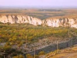
4 Location of Dam
 Comisión Internacional de Limites y Agua (CILA)")
5 Project Description Constructed between 1963 and 1969 by the United States and Mexico Total length of the dam = 6 miles Maximum Height of the Concrete Section = 254 ft Maximum Height of Embankments =122 ft 16 Tainter Gates Zoned Embankment Dam Ownership is shared by US and Mexico United States International Boundary and Water Commission (USIBWC) Comisión Internacional de Limites y Agua (CILA)

6 Plan and Profile of Dam

7 Stratigraphic Column
8 Background Seepage History Recent Investigation Database/GIS Construction Next Steps


9 Purpose and Objectives of the Investigation Geology and Foundation Treatment

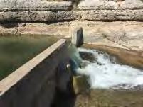


10 Purpose and Objectives of the Investigation Sinkholes, Springs, and Past Remediation Methods Play Videos 1 and 2


11 Foundation Treatment Single row grout curtain at base of core No foundation filters or widespread surface treatment Exposed solution features were cleaned out and filled with concrete
12 Performance Reviews 2005/6 Periodic Inspection prompted report to IBWC Commissioners IBWC (Dam Owners) hired USACE as their technical advisors Amistad Dam was rated a DSAC 2 Quantitative Risk Analysis performed Dam Safety Modification Study nearly complete
13 Background Seepage History Recent Investigation Database/GIS Construction Next Steps
14 Investigation Components Dye Tracing Surface Geophysics Exploratory Boreholes Downhole Geophysics Laboratory testing of Rock and Soil Observation Well Installation and Automation Detention Basin Construction & Instrumentation Contracted out to AECOM, Overseen by USACE Performed in


15 Subsurface Investigation US Side Borings and Wells Boring locations and drilling methods selected to: Determine filter compatibility between core and shell materials Investigate phreatic surface level across selected cross sections Six Vertical Borings Drilled in Dam Core Zone Sonic drilling method, continuous core sample recovered 35 m (115 ft) target depth Bore holes either tremie backfilled with bentonite cement grout or a PVC open stand-pipe well installed Truck Sonic Drill Rig and Support Truck Sonic Core Samples - Core of Dam
 Four Inclined Borings Drilled in Downstream Shell Zone Sonic drilling")


16 Subsurface Investigation US Side Borings and Piezometers (Cont.) Four Inclined Borings Drilled in Downstream Shell Zone Sonic drilling method, continuous core sample recovered 124 ft to 141 ft target depth PVC open stand-pipe piezometers installed in each boring Water encountered at the base of the shell in E-CI-1B and W-CI-2 Deviation surveys performed on all borings Sonic Core Samples from Downstream Shell of Dam Track Sonic Drill Rig Page 16


17 Mexico Side Dye Tracer Study


18 Mexico Side Dye Trace Study

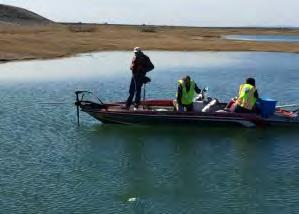
19 Mexico Side Surface Geophysical Survey
 Multi-Channel")
")
 Resistivity Equipment Striking Plate with")
20 Surface Geophysical Survey Methods Microgravity Electrical Resistivity Imaging (ERI) Multi-Channel Analysis of Surface Waves (MASW) Performed Work Upstream toe, downstream toe, and centerline (4,734 m) 4 Upstream area lines (945 m) 4 Downstream area lines (1206 m) Resistivity Equipment Striking Plate with Hammer Microgravity Equipment

21 Mexico Side Drilling and Testing


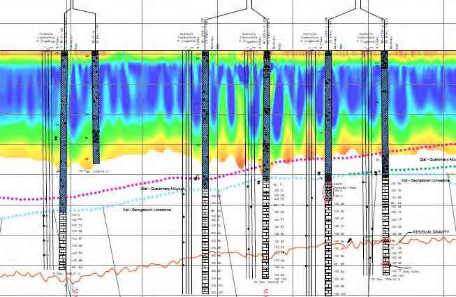
22 Mexico Side Drilling and Testing 7 Geophysics Calibration Borings: 2 upstream, 1 crest, and 4 downstream Confirmed anomalies include: intensely fractured rock close to ground surface, cavities, thicker layer of Del Rio Clay, fault, higher water table, etc. Typically, a cavity was confirmed when there was a large dip in the microgravity and a large area of low resistivity.

23 Mexico Side Drilling and Testing 3 Vertical and 12 Inclined Crest Borings 1 Vertical and 4 Inclined Upstream Borings 3 Vertical and 22 Inclined Downstream Borings 4 Inclined Side Slope Borings Sonic Drilling through Soil and Marl HQ Coring through Rock Downhole geophysics in all borings
24 Mexico Side Findings 36 Cavities Total, between 2 inches and 45 feet long
25 Page 25 Mexico Side Findings Water Pressure Testing


26 Mexico Side Findings Cavity in Vertical BoringW-U-4 Cavity at W-D-14 Page 26


27 Mexico Side Findings W-U-5


28 Mexico Side Findings


29 Mexico Side Findings Fault Under Dam at W-D-11 7-foot Cavity at W-D-14

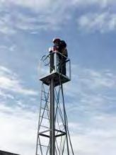
30 Automated Piezometer System Some exploratory holes were converted to observation wells and automated
31 Background Seepage History Current Investigation Database/GIS Construction Next Steps


32 Database Construction Historical Information 3D Elements Investigation Data Database & GIS Cross- Sections and Profiles Aerials and Contour Mapping

33 2D Components of the 3D GIS
34 3D GIS
35 3D GIS
36 3D GIS

37 3D GIS
38 3D GIS

39 3D GIS

40 3D GIS Zoomed View
41 Background Seepage History Recent Investigation Database/GIS Construction Next Steps
42 Next Steps USACE finishes Dam Safety Modification Study and Report Take chosen repair to 100-percent design Construct repair on dam
43 Special Thanks Go To International Boundary and Water Commission Comisión de Aqua y Límites ConAgua US Bureau of Reclamation

44 Questions?
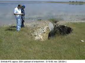
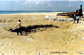
45 For Official Use Only Upstream Sinkholes


46 Downstream Springs
 Three Vertical Borings in Downstream Area PVC open stand-pipe")

47 Subsurface Investigation US Side Borings and Piezometers (Cont.) Three Vertical Borings in Downstream Area PVC open stand-pipe piezometer installed in each boring Sonic drilling method, continuous core sample recovered Depth varies from 13 to 22 feet bgs


48 Test Pits Subsurface Investigation US Side Borings, Test Pits, and Piezometers Three test pits completed on the downstream side ramp Boulders encountered in all of the test pits.

49 Subsurface Investigation US Side Filter Compatibility Preliminary Analysis

 Design and Construction of Settling Tanks Create a 3-Dimensional Geologic Model")
50 Summary of Investigation Tasks Phase I: Dye Tracer Testing Surface Geophysics: Gravity, Resistivity, Seismic Phase II: Drill on US Side and Install Wells US Side Laboratory Testing Use Phase I information to select the proposed boring locations for Mexico side Phase III: Drill borings on Mexico Side and Install Wells Mexico Side Laboratory Testing Excavate Test Pits at Potential Borrow Area Phase IV: Plan and Install the automatic data acquisition system (ADAS) Design and Construction of Settling Tanks Create a 3-Dimensional Geologic Model Page 51
TAKING THE MYSTERY OUT OF USACE S ER DRILLING IN EARTH EMBANKMENT DAMS AND LEVEES
 TAKING THE MYSTERY OUT OF USACE S ER 1110-1-1807 DRILLING IN EARTH EMBANKMENT DAMS AND LEVEES 237 237 237 217 217 217 200 200 200 80 119 27 252 174.59 1 255 255 255 0 0 0 163 163 163 131 132 122 239 65
10. GEOTECHNICAL EXPLORATION PROGRAM
 Geotechnical site investigations should be conducted in multiple phases to obtain data for use during the planning and design of the tunnel system. Geotechnical investigations typically are performed in
November 20, 2003 Project
 November 20, 2003 Project 032810 1021 Main Street Winchester, MA 01890-1970 781.721.4000 781.721.4073 fax Mr. Bobby Van Cleave Geotechnical Engineer Little Rock District Federal Building, 7th Floor 700
Gotechnical Investigations and Sampling
 Gotechnical Investigations and Sampling Amit Prashant Indian Institute of Technology Gandhinagar Short Course on Geotechnical Investigations for Structural Engineering 12 14 October, 2017 1 Purpose of
OVERVIEW OF ER DRILLING IN EARTH EMBANKMENT DAMS AND
 OVERVIEW OF ER 1110-1-1807 DRILLING IN EARTH EMBANKMENT DAMS AND 255 255 255 237 237 237 0 0 0 217 217 217 LEVEES 163 163 163 200 200 200 131 132 122 239 65 53 80 119 27 110 135 120 Requirements and Processes
ENCE 3610 Soil Mechanics. Site Exploration and Characterisation Field Exploration Methods
 ENCE 3610 Soil Mechanics Site Exploration and Characterisation Field Exploration Methods Geotechnical Involvement in Project Phases Planning Design Alternatives Preparation of Detailed Plans Final Design
HOOVER DAM: Grout Curtain Failure and Lessons Learned in Site Characterization
 HOOVER DAM: Grout Curtain Failure and Lessons Learned in Site Characterization J. David Rogers Dams Symposium Association of Engineering Geologists Annual Meeting Las Vegas, Nevada September 22, 2005 The
Geosynthetics Applications and Performance Reviews Select Case Histories
 Geosynthetics Applications and Performance Reviews Select Case Histories Debora J. Miller, Ph.D., P.E.; Dean B. Durkee,, Ph.D., P.E.; Michael A. Morrison, P.E., David B. Wilson, P.E., and Kevin Smith,
Appendix F. Geotechnical Analyses
 Appendix F Geotechnical Analyses US Army Corps Of Engineers Little Rock District CLEARWATER DAM BLACK RIVER, MISSOURI MAJOR REHABILITATION PROGRAM SEEPAGE EVALUATION GEOTECHNICAL ANALYSES CESWL-EC-DG February2004
Applied Geophysics for Environmental Site Characterization and Remediation
 Applied Geophysics for Environmental Site Characterization and Remediation MSECA Webinar September 24, 2015 John Mundell, P.E., L.P.G. Ryan Brumbaugh, L.P.G. MUNDELL & ASSOCIATES, INC. Webinar Objective
Slope Stability Evaluation Ground Anchor Construction Area White Point Landslide San Pedro District Los Angeles, California.
 Slope Stability Evaluation Ground Anchor Construction Area White Point Landslide San Pedro District Los Angeles, California Submitted To: Mr. Gene Edwards City of Los Angeles Department of Public Works
High Resolution Geophysics: A Better View of the Subsurface. By John Jansen, P.G., Ph.D., Aquifer Science and Technology
 High Resolution Geophysics: A Better View of the Subsurface By John Jansen, P.G., Ph.D., Aquifer Science and Technology Geologist Use Only Part of the Information Available To Them Most Geologist rely
Managing Our Water Retention Systems
 Managing Our Water Retention Systems 29th Annual USSD Conference Nashville, Tennessee, April 20-24, 2009 Hosted by Corps of Engineers On the Cover Wolf Creek Dam is on the Cumberland River in South Central
CONCEPTUAL DAM DESIGN
 II. CONCEPTUAL DAM DESIGN The geologic assessment resulted in moving the dam site several thousand feet upstream from the original proposed location. The most favorable of the sites considered, from a
Qualitative Foundation Rock Block Stability Evaluation Performed for Green Peter Dam
 Qualitative Foundation Rock Block Stability Evaluation Performed for Green Peter Dam Todd N. Loar, CEG Senior Geological Engineer USACE Risk Management Center AAARRR!!!... Peck, Peck, Terzaghi, Goodman,
FRED BURR DAM FEASIBILITY STUDY
 FRED BURR DAM FEASIBILITY STUDY Fred Burr Dam Feasibility Study Purpose: Develop pre-feasibility risk reduction alternatives and recommendations for short-term operations and long-term rehabilitation.
BOLIVAR DAM GROUT CURTAIN CONSTRUCTION Muskingum River Basin, OH
 BOLIVAR DAM GROUT CURTAIN CONSTRUCTION Muskingum River Basin, OH AEG Annual Meeting September 2016 Mike Nield, Geologist U.S. Army Corps of Engineers, Huntington WV LRD Dam Safety Production Center Dam
UNCONVENTIONAL DEEP-WATER GPR INVESTIGATION OF DRILLING OBSTRUCTIONS. Abstract
 UNCONVENTIONAL DEEP-WATER GPR INVESTIGATION OF DRILLING OBSTRUCTIONS Jutta Hager, Hager GeoScience, Inc., Woburn, MA Mario Carnevale, Hager GeoScience, Inc., Woburn, MA Brian R. Jones, Hager GeoScience,
Rogun Hydropower Project
 Rogun Hydropower Project Dam site Geological investigations in the Downstream Right Bank Ascencio Lara Coyne et Bellier Almaty, 11-12 February 2013 Objectives of the presentation As the stability conditions
VOLUME 13 ISSUE ISSN Association of State
 VOLUME 13 ISSUE 1 2015 ISSN 1944-9836 Association of State Dam Safety Officials The Importance of Integrating Historical Data in Preventing a Failure of the Lake Manatee Dam Glen R. Andersen Mark R. Simpson
Geophysical Exploration in Water Resources Assessment. John Mundell, P.E., L.P.G., P.G. Ryan Brumbaugh, L.P.G. Mundell & Associates, Inc.
 Geophysical Exploration in Water Resources Assessment John Mundell, P.E., L.P.G., P.G. Ryan Brumbaugh, L.P.G. Mundell & Associates, Inc. Presentation Objective Introduce the use of geophysical survey methods
CONSTRUCTION DEWATERING AT SALUDA DAM
 CONSTRUCTION DEWATERING AT SALUDA DAM Paul C. Rizzo, P.E., Ph.D., Jeffrey M. Bair. P.E., John P. Osterle, P.E., Howard W. Gault, P.G. Saluda Dam, owned and operated by South Carolina Electric & Gas Company
Underground Risk Management Course Marina Del Rey, California November, Geotechnical Data Reports. Greg Raines, PE
 Underground Risk Management Course Marina Del Rey, California November, 2018 Geotechnical Data Reports Greg Raines, PE Gregory.Raines@Stantec.com Introduction What is a Geotechnical Data Report? The GDR
Geophysical Case studies From Texas
 Geophysical Case studies From Texas 1 PRESENTATION OUTLINE Active Growth Faults in Metropolitan Houston 1. Hockley 2. Tomball 3. Long Point 4. Pearland Foundation Case Studies Karst Geophysics in Austin:
Sonic Drilling Offers Quality Control and Non-destructive Advantages to Geotechnical and Construction Drilling on Sensitive Infrastructure Sites
 Sonic Drilling Offers Quality Control and Non-destructive Advantages to Geotechnical and Construction Drilling on Sensitive Infrastructure Sites John P. Davis Manager, Construction Drilling Services Boart
Evaluation of Public Safety at Run-of-River Dams
 Evaluation of Public Safety at Run-of-River Dams - An Illinois Statewide Program By G. Nicholas Textor, PE, CFM Daniel W. Tornil Lee Von Gynz-Guethle, CFM Authority Section 23a of the Rivers, Lakes and
Geophysical Methods for Screening and Investigating Utility Waste Landfill Sites in Karst Terrain
 Geophysical Methods for Screening and Investigating Utility Waste Landfill Sites in Karst Terrain Gary Pendergrass, PE, RG, F.NSPE Principal Geological Engineer Kansas City Geotechnical Conference 2017
Hydraulic Impacts of Limestone Quarries and Gravel Pits. Jeff Green Minnesota DNR-Division of Ecological & Water Resources
 Hydraulic Impacts of Limestone Quarries and Gravel Pits Jeff Green Minnesota DNR-Division of Ecological & Water Resources The Hydraulic Impacts of Limestone Quarries and Gravel Pits Study was funded by
Pressure Grouting of Fractured Bedrock to Control Acid Mine Drainage
 WATER RESOURCES AT RISK May 14-18, 1995 Denver American Institute of Hydrology Pressure Grouting of Fractured Bedrock to Control Acid Mine Drainage S. A. Effner, G. D. Vandersluis, and V. Straskraba Hydro-Geo
CCR Rule Annual Inspection Report (cont.) 2
 2") The inspection findings consisted of maintenance items and items that were not observed to be signs or potential signs of significant structural weakness. No deficiencies or disrupting conditions that
The inspection findings consisted of maintenance items and items that were not observed to be signs or potential signs of significant structural weakness. No deficiencies or disrupting conditions that
NEEDLES S STREET LEVEE SYSTEM SAN BERNARDINO COUNTY, CALIFORNIA NLD SYSTEM ID #
 SAN BERNARDINO COUNTY, CALIFORNIA NLD SYSTEM ID # 3805030008 PERIODIC INSPECTION REPORT NO. 1 GENERALIZED EXECUTIVE SUMMARY FINAL SYSTEM RATING: MINIMALLY ACCEPTABLE FINAL RATING DATE: AUGUST 2014 PERIODIC
An Introduction to Field Explorations for Foundations
 An Introduction to Field Explorations for Foundations J. Paul Guyer, P.E., R.A. Paul Guyer is a registered mechanical engineer, civil engineer, fire protection engineer and architect with over 35 years
IAEA SAFETY STANDARDS Geotechnical Aspects of Site Evaluation and Foundations in NPPs, NS-G-3.6
 IAEA SAFETY STANDARDS Geotechnical Aspects of Site Evaluation and Foundations in NPPs, NS-G-3.6 Regional Workshop on Volcanic, Seismic, and Tsunami Hazard Assessment Related to NPP Siting Activities and
3.0 SUMMARY OF FINDINGS
 AECOM 500 W Jefferson St. Suite 1600 Louisville, KY 40202 www.aecom.com 502-569-2301 tel 502-569-2304 fax October 17, 2018 Big Rivers Electric Corporation Sebree Generating Station 9000 Highway 2096 Robards,
Engineer. Engineering. Engineering. (in-ja-neer ) A person trained and skilled in any of the various branches of engineering: a civil engineer
 A person trained and skilled in any of the various branches of engineering: a civil engineer") Engineer (in-ja-neer ) A person trained and skilled in any of the various branches of engineering: a civil engineer (Random House Webster s College Dictionary, 1991) CE100 Introduction to Civil Geotechnical
Engineer (in-ja-neer ) A person trained and skilled in any of the various branches of engineering: a civil engineer (Random House Webster s College Dictionary, 1991) CE100 Introduction to Civil Geotechnical
KARST MAPPING WITH GEOPHYSICS AT MYSTERY CAVE STATE PARK, MINNESOTA
 KARST MAPPING WITH GEOPHYSICS AT MYSTERY CAVE STATE PARK, MINNESOTA By Todd A. Petersen and James A. Berg Geophysics Program Ground Water and Climatology Section DNR Waters June 2001 1.0 Summary A new
Engineering Geophysical Application to Mine Subsidence Risk Assessment
 Engineering Geophysical Application to Mine Subsidence Risk Assessment By: Kanaan Hanna, Sr. Mining Engineer Steve Hodges, Sr. Geophysicist Jim Pfeiffer, Sr. Geophysicist Dr. Keith Heasley, Professor West
Background. Valley fills Sites in the Area. Construction over Mine Spoil Fills
 Construction over Mine Spoil Fills Wayne A. Karem, PhD, PE, PG, D.GE 2014 KSPE Annual Conference Background Strip mining; mountaintop and contour mining Creates huge quantities of mine spoil The mine spoil
APPENDIX C HYDROGEOLOGIC INVESTIGATION
 Figure B-5.7 Figure B-5.8 Preliminary Geotechnical and Environmental Report Appendix C Hydrogeologic Investigation APPENDIX C HYDROGEOLOGIC INVESTIGATION December 21, 2011 WESTSIDE SUBWAY EXTENSION PROJECT
HISTORY OF CONSTRUCTION FOR EXISTING CCR SURFACE IMPOUNDMENT PLANT GASTON ASH POND 40 CFR (c)(1)(i) (xii)
(1)(i) (xii)") HISTORY OF CONSTRUCTION FOR EXISTING CCR SURFACE IMPOUNDMENT PLANT GASTON ASH POND 40 CFR 257.73(c)(1)(i) (xii) (i) Site Name and Ownership Information: Site Name: E.C. Gaston Steam Plant Site Location:
HISTORY OF CONSTRUCTION FOR EXISTING CCR SURFACE IMPOUNDMENT PLANT GASTON ASH POND 40 CFR 257.73(c)(1)(i) (xii) (i) Site Name and Ownership Information: Site Name: E.C. Gaston Steam Plant Site Location:
Horizontal Directional Drilling: An Approach to Design and Construction. Presenter: John Briand, PE Co-Author: Danielle Neamtu, PE
 Horizontal Directional Drilling: An Approach to Design and Construction Presenter: John Briand, PE Co-Author: Danielle Neamtu, PE Presentation Outline General HDD overview Conceptual-level evaluation Detailed
Todd N. Loar, PG, CEG
 1 USACE DAM RISK ASSESSMENT PROGRAM OVERVIEW AND HOW ENGINEERING GEOLOGY CONTRIBUTES TO THE LEVEL OF CONFIDENCE AND RESULTS 255 255 255 237 237 237 217 217 217 200 200 200 0 0 0 163 163 163 131 132 122
Geotechnical Investigation Juneau Seawalk - Taku Fisheries to Miner s Wharf Juneau, Alaska DM&A Job No
 Duane Miller & Associates 5821 Arctic Boulevard, Suite A Anchorage, AK 99518-1654 (907) 644-3200 Fax 644-0507 Arctic & Geotechnical Engineering May 4, 2006 Tetra Tech/KCM, Inc. 1971 First Avenue Seattle,
THE NEED FOR AN ADDITIONAL SPILLWAY AT THE SANFORD DAM BOILING SPRING LAKES, NC. Presentation for The Brunswick County Commissioners April 20, 2015
 THE NEED FOR AN ADDITIONAL SPILLWAY AT THE SANFORD DAM BOILING SPRING LAKES, NC Presentation for The Brunswick County Commissioners April 20, 2015 The Sanford Dam Earth Dam constructed in 1961 Drainage
Finding Large Capacity Groundwater Supplies for Irrigation
 Finding Large Capacity Groundwater Supplies for Irrigation December 14, 2012 Presented by: Michael L. Chapman, Jr., PG Irrigation Well Site Evaluation Background Investigation Identify Hydrogeologic Conditions
KDOT Geotechnical Manual Edition. Table of Contents
 KDOT Geotechnical Manual 2007 Edition The KDOT Geotechnical Manual is available two volumes. Both volumes are very large electronic (pdf) files which may take several minutes to download. The table of
Bedrock Dewatering for Construction of Marmet and Soo Lock Projects
 Bedrock Dewatering for Construction of Marmet and Soo Lock Projects Michael Nield Engineering Geologist Dam Safety Production Center, Huntington, WV August 2012 US Army Corps of Engineers BEDROCK DEWATERING
CHAPTER 6, PRELIMINARY SITE INVESTIGATION CONTENTS
 CHAPTER 6, PRELIMINARY SITE INVESTIGATION CONTENTS - Page Purpose... 6-1 Assembly of data... 6-1 Use of aerial photographs... 6-2 Field study... 6-3 Mappix... 6-4 Repcrt of preliminary investigation...
Sediment Trap. A temporary runoff containment area, which promotes sedimentation prior to discharge of the runoff through a stabilized spillway.
 Sediment Trap SC-15 Source: Caltrans Construction Site Best Management Practices Manual, 2003. Description A temporary runoff containment area, which promotes sedimentation prior to discharge of the runoff
A. Refer to Appendix F in back of lab manual for list of commonly used geologic map symbols
 Structural Geology Lab 2: Outcrop Patterns and Structure Contours I. Geologic Map Symbols A. Refer to Appendix F in back of lab manual for list of commonly used geologic map symbols 1. Emphasis: a. strike
CCR Rule Compliance: Innovative Use of Geophysics to Certify Landfill Stability and Site Groundwater Monitoring Wells
 CCR Rule Compliance: Innovative Use of Geophysics to Certify Landfill Stability and Site Groundwater Monitoring Wells Gary Pendergrass, PE, RG Principal Geological Engineer Missouri Waste Control Coalition
Session - Road Building Fundamentals
 Session - Road Building Fundamentals Topic Foundation Conditions Materials & Performance of Facility Soil/Rock Properties Dave Peterson, P.G., SVP, Principal Geologist November 14, 2013 2013 Arizona Pavements/Materials
REPEATABILITY OBSERVATIONS FROM A 2D TIME-LAPSE SEISMIC SURVEY. Abstract
 REPEATABILITY OBSERVATIONS FROM A 2D TIME-LAPSE SEISMIC SURVEY Downloaded 07/03/14 to 129.237.143.21. Redistribution subject to SEG license or copyright; see Terms of Use at http://library.seg.org/ Shelby
HOW. HOW vehicle mounted units portable units also available. HOW, WHEN & WHY to Geophysically Log in S.I.?
 HOW, WHEN & WHY to Geophysically Log in S.I.? by Kim Beesley HOW HOW vehicle mounted units portable units also available Access to borehole Depth of borehole sump / rat -hole? 1 HOW? - subject to borehole
June 9, R. D. Cook, P.Eng. Soils Engineer Special Services Western Region PUBLIC WORKS CANADA WESTERN REGION REPORT ON
 PUBLIC WORKS CANADA WESTERN REGION REPORT ON GEOTECHNICAL INVESTIGATION PROPOSED MARTIN RIVER BRIDGE MILE 306.7 MACKENZIE HIGHWAY Submitted by : R. D. Cook, P.Eng. Soils Engineer Special Services Western
Calibration of Seepage and Stability Models for analysis of Dams and Levees. Francke C Walberg Consulting Geotechnical Engineer, AECOM
 Calibration of Seepage and Stability Models for analysis of Dams and Levees Francke C Walberg Consulting Geotechnical Engineer, AECOM Focus Use of models for; Evaluation of existing dams and levees Rehabilitation
Limited Visual Dam Safety Inspections OA Oahu Reservoir No Oahu, Hawaii
 Limited Visual Dam Safety Inspections OA00137 Oahu Reservoir No. 155 Oahu, Hawaii Prepared by: U.S. ARMY CORPS OF ENGINEERS HONOLULU DISTRICT STATE OF HAWAII DEPARTMENT OF LAND AND NATURAL RESOURCES May
Is It Safe to Frack Beneath Lake Lewisville?
 Is It Safe to Frack Beneath Lake Lewisville? Jerry Bartz, 2016 Data in this presentation are provisional and subject to revision and released on the condition that the author shall not be held liable for
PLATE 6 FEB G r o v e l a n d F l o o d w a l l - B o r e h o l e M a p. Legend. Groveland Floodwall Boreholes. Contour Lines.
 611 6 Defau FALS conto Conto DPLV lt Eurs20 01_to 3po Defau FALS conto Conto DPLV lt Eurs20 01_to 4po 612 Conto DPLV conto Defau FALS 01_to urs20 Elt po 5 Conto DPLV conto Defau FALS 01_to urs15 Elt po
Module 1 : Site Exploration and Geotechnical Investigation
 Objectives In this section you will learn the following Displacement borings Wash boring Auger boring Rotary drilling Percussion drilling Continuous sampling Boring methods of exploration The boring methods
SEISMIC REFRACTION SURVEY RIPPABILITY STUDY
 SEISMIC REFRACTION SURVEY RIPPABILITY STUDY US 95A SILVER SPRINGS to FERNLEY LYON COUNTY August 2008 E.A. 73455 MATERIALS DIVISION SEISMIC REFRACTION SURVEY RIPPABILITY STUDY LYON COUNTY US 95A SILVER
Rotary Drilling Rotary Drilling Bits
 GE 343 SUBSURFACE EXPLORATION CH 8 Rock Drilling, Testing, and Sampling Text Ch. 7. Dr. Norbert H. Maerz Missouri University of Science and Technology (573) 341-6714 norbert@mst.edu Instructional Objectives
Practical methodology for inclusion of uplift and pore pressures in analysis of concrete dams
 Practical methodology for inclusion of uplift and pore pressures in analysis of concrete dams Michael McKay 1 and Francisco Lopez 2 1 Dams Engineer, GHD Pty 2 Principal Dams/Structural Engineer, GHD Pty
GEOTECHNICAL ENGINEERING II. Subject Code : 06CV64 Internal Assessment Marks : 25 PART A UNIT 1
 GEOTECHNICAL ENGINEERING II Subject Code : 06CV64 Internal Assessment Marks : 25 PART A UNIT 1 1. SUBSURFACE EXPLORATION 1.1 Importance, Exploration Program 1.2 Methods of exploration, Boring, Sounding
SEISMIC SURVEY METHODS
 SEISMIC SURVEY METHODS Seismic methods Seismic surveys are used in geology and geotechnical engineering to: a) define the depth of the bedrock; b) investigate the landslide areas, c) check the structural
Association of Environmental & Engineering Geologists (AEG) To join AEG: Student membership is Free! Ask about our scholarships.
 To join AEG: Student membership is Free! Ask about our scholarships.") Association of Environmental & Engineering Geologists (AEG) To join AEG: www.aegweb.org/join Student membership is Free! Ask about our scholarships. What is the Association of Environmental & Engineering
Association of Environmental & Engineering Geologists (AEG) To join AEG: www.aegweb.org/join Student membership is Free! Ask about our scholarships. What is the Association of Environmental & Engineering
EXTREMELY FAST IP USED TO DELINEATE BURIED LANDFILLS. Norman R. Carlson, Cris Mauldin Mayerle, and Kenneth L. Zonge
 EXTREMELY FAST IP USED TO DELINEATE BURIED LANDFILLS Norman R. Carlson, Cris Mauldin Mayerle, and Kenneth L. Zonge Zonge Engineering and Research Organization, Inc. 3322 East Fort Lowell Road Tucson, Arizona,
Instructional Objectives
 GE 6477 DISCONTINUOUS ROCK 8. Fracture Detection Dr. Norbert H. Maerz Missouri University of Science and Technology (573) 341-6714 norbert@mst.edu Instructional Objectives 1. List the advantages and disadvantages
Appendix D Rock Blasting Report
 Appendix D Rock Blasting Report 02-2500-01 May 20, 2005 Frank Arciero Jr. Fallingstar Homes 27231 Burbank Foothill Ranch, California 92610 Subject: ANTICIPATED ROCK EXCAVATION FRAZIER PARK ESTATES DEVELOPMENT
Instructional Objectives
 GE 343 SUBSURFACE EXPLORATION CH 8 Rock Drilling, Testing, and Sampling Text Ch. 7. Dr. Norbert H. Maerz Missouri University of Science and Technology (573) 341-6714 norbert@mst.edu Instructional Objectives
REPORT OF PRELIMINARY SUBSURFACE EXPLORATION SITE DESIGN EVALUATION FOR REHABILITATION OF PINE GROVE LAKE DAM
 REPORT OF PRELIMINARY SUBSURFACE EXPLORATION SITE DESIGN EVALUATION FOR REHABILITATION OF PINE GROVE LAKE DAM VILLAGE OF SLOATSBURG, ROCKLAND COUNTY, NEW YORK SUBMITTED TO: ASSOCIATION OF PROPERTY OWNERS
B-1 BORE LOCATION PLAN. EXHIBIT Drawn By: 115G BROOKS VETERINARY CLINIC CITY BASE LANDING AND GOLIAD ROAD SAN ANTONIO, TEXAS.
 N B-1 SYMBOLS: Exploratory Boring Location Project Mngr: BORE LOCATION PLAN Project No. GK EXHIBIT Drawn By: 115G1063.02 GK Scale: Checked By: 1045 Central Parkway North, Suite 103 San Antonio, Texas 78232
APPENDIX B SUBSURFACE EXPLORATIONS
 APPENDIX B SUBSURFACE EXPLORATIONS 51-1-10079-028 APPENDIX B SUBSURFACE EXPLORATIONS TABLE OF CONTENTS Page B.1. B.2. B.3. B.4. B.5. B.6. B.7. GENERAL...B-1 HEALTH AND SAFETY PLAN...B-1 DRILLING PROCEDURES...B-1
Old Oilfields vs. New Homes, Wells Case Studies, Proposed Solutions
 Old Oilfields vs. New Homes, Wells Case Studies, Proposed Solutions Patricia Billingsley, Brownfields Manager, Oklahoma Corporation Commission John Harrington, Director of Water Resources, Association
PART I A BRIEF SUMMARY OF SIX ROADWAY INVESTIGATIONS IN KARST
 METHODS USED TO CARRY OUT SIX ROADWAY INVESTIGATIONS OF SINKHOLES Richard C. Benson Technos, Inc. 3333 NW 21 st Street, Miami FL 33142 info@technos-inc.com ABSTRACT Karst conditions are a prevalent problem
CURRENT METHODOLOGY AT THE BUREAU OF RECLAMATION FOR THE NONLINEAR ANALYSES OF ARCH DAMS USING EXPLICIT FINITE ELEMENT TECHNIQUES
 CURRENT METHODOLOGY AT THE BUREAU OF RECLAMATION FOR THE NONLINEAR ANALYSES OF ARCH DAMS USING EXPLICIT FINITE ELEMENT TECHNIQUES Barbara Mills-Bria, P.E., 1 Larry Nuss, P.E. 2 and Dr. Anil Chopra 2 1
Teton Dam Failure A Review of the Technical Factors Contributing to the Failure
 Teton Dam Failure A Review of the Technical Factors Contributing to the Failure Outline of Presentation Location, Background and Project Statistics Technical Causes of Failure to be Discussed Geology
This is a digital document from the collections of the Wyoming Water Resources Data System (WRDS) Library.
 Library.") This is a digital document from the collections of the Wyoming Water Resources Data System (WRDS) Library. For additional information about this document and the document conversion process, please contact
This is a digital document from the collections of the Wyoming Water Resources Data System (WRDS) Library. For additional information about this document and the document conversion process, please contact
Mitigation of Gypsum Mine Voids Under SR-2 in Ottawa County, Ohio
 Subsurface Investigation and Conceptual Alternatives Mitigation of Gypsum Mine Voids Under SR-2 in Ottawa County, Ohio Presented By: Ohio Department of Transportation CH2M HILL CTL Engineering Technos,
Georadar Application for Dam Safety Study (Case Study of Selorejo Dam)
") The 2 nd International Seminar on Science and Technology 155 Georadar Application for Dam Safety Study (Case Study of Selorejo Dam) Teguh Winari 1, Kamsiyah Windianita 1, and Fahmi Hidayat 1 Abstract Selorejo
The 2 nd International Seminar on Science and Technology 155 Georadar Application for Dam Safety Study (Case Study of Selorejo Dam) Teguh Winari 1, Kamsiyah Windianita 1, and Fahmi Hidayat 1 Abstract Selorejo
MICRO TO MACRO ARE UK LINEAR INFRASTRUCTURE GI S SUITABLE FOR INVESTIGATING MASS SOIL PROPERTY CHARACTERISTICS?
 MICRO TO MACRO ARE UK LINEAR INFRASTRUCTURE GI S SUITABLE FOR INVESTIGATING MASS SOIL PROPERTY CHARACTERISTICS? Ben Gilson - Arup 1 OUTLINE 1. Context why linear infrastructure? 2. Geotechnical challenges
Boreholes. Implementation. Boring. Boreholes may be excavated by one of these methods: 1. Auger Boring 2. Wash Boring 3.
 Implementation Boreholes 1. Auger Boring 2. Wash Boring 3. Rotary Drilling Boring Boreholes may be excavated by one of these methods: 4. Percussion Drilling The right choice of method depends on: Ground
The Final Phase of San Clemente Dam Removal and Stream Restoration
 The Final Phase of San Clemente Dam Removal and Stream Restoration Godwin, W., Waeber, J., Wade, D, and McGowan, W Annual Meeting, Association of Environmental & Engineering Geologists Kona, Hawaii September
Chapter 12 Subsurface Exploration
 Page 12 1 Chapter 12 Subsurface Exploration 1. The process of identifying the layers of deposits that underlie a proposed structure and their physical characteristics is generally referred to as (a) subsurface
Stormwater Outlet Sediment Traps
 Stormwater Outlet Traps SEDIMENT CONTROL TECHNIQUES Photo 1 Excavated sediment trap just prior to scheduled clean-out (note energy dissipater at end of pipe) Photo 2 A supplementary straw bale barrier
Bridging Subsurface Geologic Databases with Cross-Sections in GIS
 Bridging Subsurface Geologic Databases with Cross-Sections in GIS Eva E. von Thury ESRI International User Conference Padre Associates, Inc. Project Geologist / GIS Analyst June 29, 2016 Outline Introduction
design, construction, operation, and maintenance of the BAP is consistent with recognized and generally accepted good engineering standards.
 design, construction, operation, and maintenance of the BAP is consistent with recognized and generally accepted good engineering standards. In addition to the field inspection, Associated Engineers, Inc.
ENGINEER S CERTIFICATION OF FAULT AREA DEMONSTRATION (40 CFR )
") PLATTE RIVER POWER AUTHORITY RAWHIDE ENERGY STATION BOTTOM ASH TRANSFER (BAT) IMPOUNDMENTS LARIMER COUNTY, CO ENGINEER S CERTIFICATION OF FAULT AREA DEMONSTRATION (40 CFR 257.62) FOR COAL COMBUSTION RESIDUALS
PLATTE RIVER POWER AUTHORITY RAWHIDE ENERGY STATION BOTTOM ASH TRANSFER (BAT) IMPOUNDMENTS LARIMER COUNTY, CO ENGINEER S CERTIFICATION OF FAULT AREA DEMONSTRATION (40 CFR 257.62) FOR COAL COMBUSTION RESIDUALS
Well Logging Importance in Oil and Gas Exploration and Production
 Well Logging Importance in Oil and Gas Exploration and Production Dr. R. Giri Prasad 1 1 Associate Professor, Dept. of Petroleum Engineering, Aditya Engineering College, hod_pt@aec.edu.in I. INTRODUCTION
Development of geophysical investigation for verifying treatment efficiency of underground cavities
 Development of geophysical investigation for verifying treatment efficiency of underground cavities Hasan A. Kamal* Kuwait Institute for Scientific Research, Infrastructure Risk and Reliability Program,
CENTRAL REGION GEOHAZARDS RISK ASSESSMENT SITE INSPECTION FORM
 SITE NUMBER AND NAME C55 H861:02 Slide LEGAL DESCRIPTION NW 14-40-14-W4 CENTRAL REGION GEOHAZARDS RISK ASSESSMENT SITE INSPECTION FORM HIGHWAY & KM NAD 83 COORDINATES N 5811217 E 437291 PREVIOUS INSPECTION
ambiguity in earth sciences IESO Geophysics Section Eddy hartantyo, Lab Geofisika FMIPA UGM
 ambiguity in earth sciences IESO Geophysics Section Eddy hartantyo, Lab Geofisika FMIPA UGM Pelatihan Tahap II IESO Teknik Geologi UGM Februari 2009 1 Introduction Photos from http://www.eegs.org/whatis/
PROBLEMS AND SOLUTIONS THAT MAY EMERGE IN THE FOUNDATION AND BODY OF A HOMOGENEOUS FILL DAM ON A WEAK CLAYEY-SILTY-SANDY FORMATION ÇIKRIKÇI DAM
 PROBLEMS AND SOLUTIONS THAT MAY EMERGE IN THE FOUNDATION AND BODY OF A HOMOGENEOUS FILL DAM ON A WEAK CLAYEY-SILTY-SANDY FORMATION ÇIKRIKÇI DAM Esen Yalım KARADUMAN BAR-SU Eng. & Conc. Inc. Ankara Turkey
Volume 2. Geotechnical Evaluation for FINGER LAKES STORAGE BRINE POND. February 25, Prepared for:
 February 25, 2011 Volume 2 Geotechnical Evaluation for FINGER LAKES STORAGE BRINE POND Prepared for: Mr. Michael LaRose Finger Lakes Storage, LLC 111 North Franklin Street Watkins Glen, New York 14891
GEOTECHNICAL POLICIES AND PROCEDURES MANUAL CHAPTER 5 GEOTECHNICAL INVESTIGATION PLANNING GUIDELINES
 GEOTECHNICAL POLICIES AND PROCEDURES MANUAL CHAPTER 5 GEOTECHNICAL INVESTIGATION PLANNING GUIDELINES GEOTECHNICAL INVESTIGATION PLANNING GUIDELINES 5-i TABLE OF CONTENTS 1. PURPOSE... 1 2. INTRODUCTION...
2 OVERVIEW OF SHALLOW BOREHOLE INVESTIGATIONS
 2 OVERVIEW OF SHALLOW BOREHOLE INVESTIGATIONS Preparation for MSB-2 started in April 2002. Drilling and planned field work in both MSB-2 and 4 were carried out at the same time. After completion of the
IN SITU SPECIFIC GRAVITY VS GRAIN SIZE: A BETTER METHOD TO ESTIMATE NEW WORK DREDGING PRODUCTION
 IN SITU SPECIFIC GRAVITY VS GRAIN SIZE: A BETTER METHOD TO ESTIMATE NEW WORK DREDGING PRODUCTION Nancy Case O Bourke, PE 1, Gregory L. Hartman, PE 2 and Paul Fuglevand, PE 3 ABSTRACT In-situ specific gravity
Early Exploration Plan Activity Information
 Early Exploration Plan Activity Information Activities That Require an Early Exploration Plan: Line cutting that is a width of 1.5 metres or less; Geophysical surveys on the ground requiring the use of
STEVENS CREEK DAM SEISMIC STABILITY EVALUATIONS OF CHESBRO, LENIHAN, STEVENS CREEK, AND UVAS DAMS (SSE2) PHASE A: STEVENS CREEK AND LENIHAN DAMS
 PHASE A: STEVENS CREEK AND LENIHAN DAMS") SEISMIC STABILITY EVALUATIONS OF CHESBRO, LENIHAN, STEVENS CREEK, AND UVAS DAMS (SSE2) PHASE A: STEVENS CREEK AND LENIHAN DAMS STEVENS CREEK DAM COMPILATION REPORT (REPORT No. SSE2A-SC) Prepared for SANTA
SEISMIC STABILITY EVALUATIONS OF CHESBRO, LENIHAN, STEVENS CREEK, AND UVAS DAMS (SSE2) PHASE A: STEVENS CREEK AND LENIHAN DAMS STEVENS CREEK DAM COMPILATION REPORT (REPORT No. SSE2A-SC) Prepared for SANTA
Stone Outlet Sediment Trap
 3.12 Sediment Control Description: A stone outlet sediment trap is a small detention area formed by placing a stone embankment with an integral stone filter outlet across a drainage swale for the purpose