APPENDIX C SUBSURFACE EXPLORATIONS
|
|
|
- Ezra Hutchinson
- 5 years ago
- Views:
Transcription
1 APPENDIX C SUBSURFACE EXPLORATIONS
2 APPENDIX C SUBSURFACE EXPLORATIONS TABLE OF CONTENTS Page C.1. C.2. C.3. C.4. C.5. C.6. GENERAL...C-1 DRILLING PROCEDURES...C-1 SAMPLING PROCEDURES...C-2 C.3.1. Rotary Core...C-2 C.3.2. Grab...C-2 ENVIRONMENTAL FIELD SCREENING FOR VOLITILE ORGANIC COMPOUNDS (VOCS)...C-2 REVIEW AND CLASSIFICATION OF SAMPLES...C-3 C.5.1. Field Observations...C-3 C.5.2. Soil Classification System...C-3 C.5.3. Geologic Units and Descriptions...C-3 C.5.4. Boring Logs...C-3 REFFERENCES...C-4 FIGURES C-1 Soil Classification and Log Key (3 sheets) C-2 Log of Boring B-1 Revised (6 sheets) C-3 Log of Boring B-7 Revised (9 sheets) C-4 Log of Boring B-10 (9 sheets) C-5 Log of Boring B-11 (9 sheets) C-6 Core Photographs Boring B-10 (10 sheets) C-7 Core Photographs Boring B-11 (10 sheets) R1-AC/wp/ADY C-i
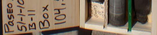
3 APPENDIX C SUBSURFACE EXPLORATIONS C.1. GENERAL Shannon & Wilson drilled two new borings at the locations shown on Plate 1. The borings were both completed to depths of feet below the existing ground surface. In total, approximately 261 feet of drilling was performed for this portion of the project. A description of the drilling methods and other field procedures used to perform the subsurface explorations is included in this appendix. Results of the explorations are included as Figures C-2 and C-3. Photographs of the rotary core samples are included as Figures C-4 and C-5. C.2. DRILLING PROCEDURES Gregg Drilling & Testing, Inc. of Signal Hill, California, provided and operated a truck-mounted CME 75 rotary drill rig to complete borings B-10 and B-11 between July 16, 2012 and July 24, The triple-tube core barrel used in the rotary core drilling method by Gregg Drilling consists of inner and outer barrels and a split inner core tube. The outer barrel rotates while the inner barrel and the inner split tube remain stationary. This system helps protect the core from the drilling fluid (mixture of soil/rock cuttings and water) and reduces the torsional forces transmitted to the core. In addition, the split inner tube allows for detailed visual analysis of the relatively undisturbed core. The system used by Gregg Drilling for this project was a HQ-3 system, where the core diameter is 2.5 inches and the borehole diameter is 3.77 inches. To ream borings B-10 and B-11 for inclinometer installation, mud-rotary drilling was performed by Gregg Drilling using a CME-75 truck-mounted drill rig equipped with a 6-inch-diameter tricone bit. During the mud-rotary drilling, bentonite drilling mud was pumped out of a mud tank at the ground surface, down the N-size (2.8-inch OD) drill rods, out through the bit at the bottom of the borehole, up the annulus of the hole between the drill rods and the borehole, and back into the mud tank. The circulating drilling mud removed the cuttings generated by the drilling process from the hole, carrying them to the surface where they were screened and removed from the circulating drilling mud R1-AC/wp/ADY C-1
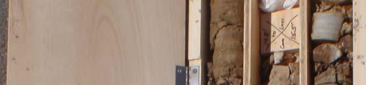
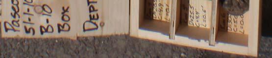
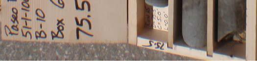
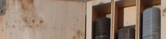
4 C.3. SAMPLING PROCEDURES C.3.1. Rotary Core The 2.5-inch-diameter core samples obtained from the rotary core borings B-10 and B-11 were photographed while in half of the inner split tube, visually examined by our field representative, and placed into core boxes. Our field representative observed the coring process, logged the core, and noted the bedding, fractures and rock quality. Rock quality is typically conveyed in terms of the Rock Quality Designation (RQD), which is defined as the sum of the length of core pieces in a given core run that are greater than 4 inches in length divided by the total core run length. The percent recovery and RQD are represented graphically on the boring logs. The samples obtained from the rotary core method are assumed to be relatively undisturbed. Rock type, relative orientations of any bedding or discontinuities, and any other pertinent features were measured, recorded and noted on the log of each boring. Selected sections of the core were removed for use in laboratory strength testing. The remaining rock core was stored in wood core boxes. The rock core was transported to our office. C.3.2. Grab Grab samples are defined as samples that are grabbed from cuttings generated from the drilling process or directly from the side or bottom of the hole using a hand-operated tool. While other types of sampling (e.g., rock core sampling or penetration test sampling) represent a specific depth in the drilled hole, grab samples often have a less accurate depth because they are compiled from a depth range within a boring. The approximate sample depth was estimated and is noted on the exploration logs. C.4. ENVIRONMENTAL FIELD SCREENING FOR VOLITILE ORGANIC COMPOUNDS (VOCS) Soil samples were field screened by the Shannon & Wilson field representative for contamination in accordance with Shannon & Wilson s Field Inspector s Guidelines. Fieldscreening methods consist of (a) visual observations, (b) photoionization detector (PID) measurements, (c) and/or olfactory observations. The PID was used to screen for the presence VOCs. Field screening did not indicate potential soil contamination. The intent of PID monitoring is to evaluate the potential presence of contamination of soil and potential exposure to VOC in the breathing zone during drilling operations R1-AC/wp/ADY C-2
5 We performed chemical testing on samples of the drill cutting and mud. The results of those tests are presented in Appendix H. C.5. REVIEW AND CLASSIFICATION OF SAMPLES C.5.1. Field Observations The borings were observed by a Shannon & Wilson field representative, who collected, classified, stored, and transported soil and rock samples; performed field screening; and prepared a detailed log of the exploration. In addition to examining and collecting soil samples, the field representatives also noted drill action, problems during drilling (e.g., heave, hole collapse, etc.), and other issues. C.5.2. Soil Classification System Soil classification for this project was based on ASTM D 2487, Standard Test Method for Classification of Soil for Engineering Purposes, and ASTM D 2488, Standard Recommended Practice for Description of Soils (Visual-Manual Procedure). The system is called the Unified Soil Classification System (USCS) and is summarized in Figure C-1. Rock classification was done in accordance with International Society of Rock Mechanics (Ulusay et al., 2007) methods. Figure C-1 presents a summary of the ISRM rock classification system. C.5.3. Geologic Units and Descriptions The geologic units as described in the report are used to maintain consistency when defining geology encountered in the borings throughout the project area. These geologic units are interpretive and are based on our review of existing geologic literature for the project area. The geologic unit designations for each soil layer are shown in the descriptions in the boring logs included in this appendix. C.5.4. Boring Logs A boring log is a written record of the subsurface conditions encountered in the exploration. It shows the soil layers encountered in the exploration and the rock or USCS symbol of each layer. The boring logs presented in this appendix include a numerical representation of the uncorrected blow counts measured in the penetration tests and the results of selected laboratory index tests (see Appendix H). Other information shown in the boring logs includes groundwater level measurements, horizontal coordinates, surface elevation, and types and depths of sampling. In boreholes where downhole televiewer was performed, measured bedding and discontinuity attitudes are shown on the boring logs R1-AC/wp/ADY C-3
6 The review and completion of the final boring logs were performed by following a Quality Assurance/Quality Control (QA/QC) process developed by Shannon & Wilson. This program includes review of the samples by an experienced geologist after initial field observations are made, cross-checks with laboratory test results, and further cross-checks with developed geologic profiles. This detailed procedure is followed to assure consistency of the data presentation and to provide adequate QC for each exploration. Revised boring logs, showing corrected attitudes, are presented for borings B-1 and B-7. C.6. REFFERENCES ASTM International (ASTM), 2006, Annual Book of Standards-Construction, v. 4.08, soil and rock, (I): D 420 D 5611: West Conshohocken, Pa Ulusay, Resat and Hudson, J. A., eds., 2007, The complete ISRM suggested methods for rock characterization, testing and monitoring: : Ankara, Commission on Testing Methods, International Society of Rock Mechanics, 628 p R1-AC/wp/ADY C-4
7
8
9
10 131.2 ft ft. Northing: Easting: Station: Offset: ft ft. HSA/HQ/AR Jet Drilling CME 75 Hammer Type: Asphalt Surface of Paseo Del Mar 3.5 in. AWJ Automatic SOIL DESCRIPTION Asphalt Paving. Stiff to very stiff, brownish-black (5YR 2/1), slightly sandy to sandy, silty CLAY; moist; scattered small ash blebs; (Qt) CH/CL. 1.0 S S Typ: Rev: Log: Disturbed, stiff to very stiff, very pale orange (10YR 8/2) to mottled, pale yellowish-brown (10YR 6/2) and moderate yellowish-brown (10YR 5/4), clayey SILT to silty CLAY, moist; locally slightly fine to medium sandy, scattered to numerous silty clay clasts and ash blebs, scattered silt clasts at about 8.5 feet, disturbed fine sandstone seam at about 6.7 feet; (Qt) CL/ML. SILTSTONE TO CLAYSTONE: Very low strength, very pale orange (10YR 8/2) to moderate yellowish-brown (10YR 5/4), interbedded, locally laminated; scattered highly fractured/disturbed layers, scattered warped layers and clasts, (Tma). CLAYSTONE: Very low strength, mottled, moderate yellowish-brown (10YR 5/4), grayish-orange (10YR 7/4) and dark yellowish-brown (10YR 6/6), interbedded with silicious to clayey siltstone, scattered irregular/discontinous fine-grained sandstone seams or zones, locally irregularly laminated, disturbed bedding; scattered ash beds; iron-oxide stained; highly weathered to completely weathered, (Tma) S-3 S-4 S-5 S-6 S-7 S-8 S BUCKET_AUGER_RQD SAN PEDRO LANDSLIDE.GPJ SAN PEDRO LANDSLIDE.GPJ 11/16/ SILTSTONE to CLAYSTONE: Very low strength, moderate yellowish-brown (10YR 5/4) and dark yellowish-brown (10YR 6/6) to pale yellowish-brown (10YR 6/2), interbedded, scattered fine-grained sandstone seams, bedding horizontal to dipping at about 10 degrees, locally warped laminae; scattered ash blebs; iron-oxide stained; highly weathered to completely weathered, (Tma). SANDSTONE: Very low to low strength, moderate yellowish-brown (10YR 5/4) and pale yellowish-brown (10YR 6/2) to grayish-orange (10YR 7/4), fine-grained, scattered thin siltstone interbeds; locally highly fractured; iron-oxide stained; highly fractured at about 20 to 21.5 feet and 23 to 23.5 feet; moderately weathered to highly weathered (Tma). SILTSTONE: Very low strength, moderate yellowish-brown (10YR 5/4) to yellowish-gray (5Y 7/2), scattered fine to medium-grained sandstone layers, thin-bedded, bedding dipping at about 10 to 15 degrees; very close to closely spaced joints, locally highly fractured; scattered ash * Sample Not Recovered Level ATD Modified California Sampler CONTINUED NEXT SHEET S-10 S-11 S-12 S-13 S-14 S /9" LOG OF BORING B-1 November FIG. C Sheet 1 of 6 REV 3.1
11 131.2 ft ft. Northing: Easting: Station: Offset: ft ft. HSA/HQ/AR Jet Drilling CME 75 Hammer Type: Asphalt Surface of Paseo Del Mar 3.5 in. AWJ Automatic 95 SOIL DESCRIPTION blebs, highly weathered, (Tma). SANDSTONE: Low to high strength, gray-orange (10YR 7/4) to olive black (5Y 2/1), interbedded with silicious siltstone, laminated to thin-bedded; moderately weathered to slightly weathered, (Tma). Note: Description based on poor sample recovery S-16 S-17 S /4" 50/6" S S Typ: 90 SILTSTONE: Very low strength, gray-orange (10YR 7/4) to yellowish-gray (5Y 8/1), scattered clayey siltstone to claystone seams, laminated to thin-bedded, bedding dipping at 20 to 50 degrees; very close to closely spaced low to high angle joints locally infilled with gypsum; moderately weathered to slighlty weathered, (Tma) S Rev: Log: 85 S-22 BUCKET_AUGER_RQD SAN PEDRO LANDSLIDE.GPJ SAN PEDRO LANDSLIDE.GPJ 11/16/ SANDSTONE: Very low to low strength, light olive gray (5Y 6/1), fine to medium-grained; scattered gypsum infilled joints; slightly weathered to fresh, (Tma). SILTSTONE: Low strength, light olive gray (5Y 6/1), silicious, massive; wide-spaced, iron-oxide stained fracture; slightly weathered to fresh, (Tma). CLAYSTONE: Very low strength, light olive gray (5Y 6/1) and olive black (5Y 2/1), very thin-bedded; close spaced, slickensided joints with offset bedding; cross-cut siltstone layers at 46.3 feet, fresh (Tma). SANDSTONE: Very low strength, light olive gray (5Y 6/1), fine to medium-grained, scattered syndepositionally disturbed layers of claystone and siltstone; scattered undulating iron-oxide stained fractures; slightly weathered to fresh, (Tma). SILTSTONE: Very low strength, light olive gray (5Y 6/1) and olive black (5Y 2/1), interbedded clayey siltstone and silicious siltstone, laminated * Sample Not Recovered Level ATD Modified California Sampler CONTINUED NEXT SHEET S-23 S LOG OF BORING B-1 November FIG. C Sheet 2 of 6 REV 3.1
12 131.2 ft ft. Northing: Easting: Station: Offset: ft ft. HSA/HQ/AR Jet Drilling CME 75 Hammer Type: Asphalt Surface of Paseo Del Mar 3.5 in. AWJ Automatic Typ: SOIL DESCRIPTION to thin-bedded, bedding dipping at about 10 degrees; scattered ash blebs; fresh, (Tma). SANDSTONE: Very low strength, light olive gray (5Y 6/1), fine to coarse-grained, locally interbedded with siltstone and claystone layers from 50 to 51 feet, horizontally bedded to locally syndepositionally disturbed with rip up clasts and disturbed bedding, laminated to medium bedded; scattered gypsum filled joints; fresh, (Tma). SILTSTONE: Very low strength, light olive gray (5Y 6/1), and olive black (5Y 2/1), silicious, interbedded with clayey siltstone, laminated to thin-bedded; scattered narrow solution cavities with iron-oxide coatings and gypsum crystals; close spaced, low to high angle joints with gypsum infilling, slightly weathered to fresh, (Tma). SANDSTONE: Very low to low strength, light olive gray (5Y 6/1) and pale yellowish-brown (10YR 6/2), interbedded with irregular siltstone layers; scattered gypsum filled joints; iron-oxide stained, slightly weathered, (Tma) S-25 S Rev: 60 - No core recovery between 60 and 67.3 feet S-27* Log: BUCKET_AUGER_RQD SAN PEDRO LANDSLIDE.GPJ SAN PEDRO LANDSLIDE.GPJ 11/16/ Drilled without sampling from 67.3 to feet CONTINUED NEXT SHEET * Sample Not Recovered Level ATD Modified California Sampler S-28* S-29* LOG OF BORING B-1 November FIG. C Sheet 3 of 6 REV 3.1
13 131.2 ft ft. Northing: Easting: Station: Offset: ft ft. HSA/HQ/AR Jet Drilling CME 75 Hammer Type: Asphalt Surface of Paseo Del Mar 3.5 in. AWJ Automatic SOIL DESCRIPTION - Petroleum odor at approximately 75 feet (tar smell from tar bed) with tar pieces in cuttings Driller noted that tar bed ended at about 80 feet Typ: Rev: Log: BUCKET_AUGER_RQD SAN PEDRO LANDSLIDE.GPJ SAN PEDRO LANDSLIDE.GPJ 11/16/ CONTINUED NEXT SHEET * Sample Not Recovered Level ATD Modified California Sampler LOG OF BORING B-1 November FIG. C Sheet 4 of 6 REV 3.1
14 131.2 ft ft. Northing: Easting: Station: Offset: ft ft. HSA/HQ/AR Jet Drilling CME 75 Hammer Type: Asphalt Surface of Paseo Del Mar 3.5 in. AWJ Automatic SOIL DESCRIPTION Typ: 15 Rev: Cuttings became damp at about 109 feet. 21 During Drilling 110 Log: 10 BUCKET_AUGER_RQD SAN PEDRO LANDSLIDE.GPJ SAN PEDRO LANDSLIDE.GPJ 11/16/ During short drilling delay at about 116 feet, water had accumulated in borehole. CONTINUED NEXT SHEET * Sample Not Recovered Level ATD Modified California Sampler LOG OF BORING B-1 November FIG. C Sheet 5 of 6 REV 3.1
15 131.2 ft ft. Northing: Easting: Station: Offset: ft ft. HSA/HQ/AR Jet Drilling CME 75 Hammer Type: Asphalt Surface of Paseo Del Mar 3.5 in. AWJ Automatic SOIL DESCRIPTION BOTTOM OF BORING COMPLETED 11/29/ Typ: Rev: Log: Notes - 1) Borehole advanced to 67.3 feet deep using continuous Califormia Modified Sampler and HQ rock coring methods. 2) No core recovery at 60 to 67.3 feet deep. 3) Borehole advanced from 67.3 feet to feet deep using air rotary methods. No samples were retrieved. 4) After reaching the bottom of hole, the borehole was flushed by allowing groundwater to accumulate in borehole and then forcing the water out by turing on air supply. The procedure was done 10+ times. After standing for 1 hour, water level in borehole was measured at about 63.5 feet deep. The waterlevel in the borehole could not be maintained above a depth of 44 feet during Acoustic Televiewer logging. 5) Hole was scanned with acoustic televiewer operated by Geovision upon completion of drilling. 135 BUCKET_AUGER_RQD SAN PEDRO LANDSLIDE.GPJ SAN PEDRO LANDSLIDE.GPJ 11/16/ * Sample Not Recovered Level ATD Modified California Sampler LOG OF BORING B-1 November FIG. C Sheet 6 of 6 REV 3.1
16 117 ft ft. Northing: ft. Easting: ft. Station: Offset: Gregg Drilling Mobile B-53 Truck-Mounted Hammer Type: Hole was reamed to in. SOIL/ROCK DESCRIPTION Asphalt Paving Note - Borehole was advanced to about 4.5 feet using mud rotary drilling methods to allow for the insertion of the core barrel. No samples were collected Brownish gray (5YR 4/1) to mottled dark yellowish brown (10YR 4/2) and dark yellowish orange (10YR 6/6), clayey SILT to silty CLAY; moist; scattered clayey silt clasts, scattered to numerous nodules; (Qt) CL/ML. 4.5 R Typ: Rev: CLAYEY SILTSTONE: Very low strength, mottled greenish gray (5GY 6/1) and dark yellowish orange (10YR 6/6), completely weathered, (Tma). SILTSTONE: Very low strength, moderate yellowish brown (10Yr 5/4) and dark yellowish brown (10YR 4/2) to dark yellowish orange (10YR 6/6) and greenish gray (5GY 6/1), laminated to thin-bedded, interbedded with clayey siltstone and fine-grained sandstone, bedding horizontal to dipping to 10 degrees, sandstone locally very low to low strength; medium to wide spaced fractures with iron-oxide coatings, moderately to highly weathered, (Tma) R Log: BUCKET_AUGER_RQD SAN PEDRO LANDSLIDE.GPJ SAN PEDRO LANDSLIDE.GPJ 11/16/ SILICIOUS SILTSTONE: Low to medium high strength, light bluish gray (5B 7/1), interbedded with fine-grained sandstone; very close spaced, low to high angle irregular rough joints; slightly to moderately weathered, (Tma). SILTSTONE: Very low to low strength, moderate yellowish brown (10Yr 5/4), pale yellowish brown (10YR 6/2) and greenish gray (5GY 6/1), laminated to thin-bedded, interbedded with scattered clayey siltstone and sandstone layers, bedding dipping at about 10 to 50 degrees; very close to closely spaced fractures, locally infilled with tar or gypsum; iron-oxide stained, highly weathered to slightly weathered, (Tma). * Sample Not Recovered CONTINUED NEXT SHEET R-3 R-4 R-5 R LOG OF BORING B-7 November FIG. C Sheet 1 of 5 REV 3.1
17 117 ft ft. Northing: ft. Easting: ft. Station: Offset: Gregg Drilling Mobile B-53 Truck-Mounted Hammer Type: Hole was reamed to in. SOIL/ROCK DESCRIPTION Gypsum fracture in fillings between 30 and 41 feet. R Tar infilling in joints between 32 and 32.5 feet Typ: 27 Rev: Log: R BUCKET_AUGER_RQD SAN PEDRO LANDSLIDE.GPJ SAN PEDRO LANDSLIDE.GPJ 11/16/ SANDSTONE: Very low strength, pale yellowish brown (10YR 6/2), fine-grained; highly fractured (closed) with tar infilling; sulfur; moderately weathered, (Tma). SILTSTONE: Very low to low strength, medium gray (N5) and olive black (5Y 2/1), laminated to thin-bedded, interbedded with clayey siltstone, sandstone, and scattered claystone layers, planar bedded to chaotic with clasts of siltstone and sandstone, bedding dipping at about 30 to 60 degrees; very close to medium spaced, low to high angle joints with numerous slickenside, scattered shear zones; iron-oxide staining above about 44 feet; slightly weathered to fresh, (Tma). -Shear at 45.5 feet. -Slickensided shears between 48 and 62 feet. * Sample Not Recovered CONTINUED NEXT SHEET R-9 R-10 R LOG OF BORING B-7 November FIG. C Sheet 2 of 5 REV 3.1
18 117 ft ft. Northing: ft. Easting: ft. Station: Offset: Gregg Drilling Mobile B-53 Truck-Mounted Hammer Type: Hole was reamed to in. SOIL/ROCK DESCRIPTION R Typ: Rev: 60 R Log: 60 -Disturbed zone at 62 to 62.5 feet BUCKET_AUGER_RQD SAN PEDRO LANDSLIDE.GPJ SAN PEDRO LANDSLIDE.GPJ 11/16/ SILICIOUS SILTSTONE: High strength, light brownish gray (5YR 6/1), laminated; bedding dipping at about 80 degrees; close spaced rough fractures; fresh, (Tma). SILTSTONE: Very low to low strength; medium gray (N5) and brownish black (5YR 2/1); chaotic (syndepositional) bedding with clayey siltstone and fine to medium-grained sandstone; very close to medium spaced fractures; fresh, (Tma). -Highly fractured zone at about 68.1 to 68.6 feet. SANDSTONE: Very low to moderate strength, medium gray (N5), fine-grained, chaotic bedded with siltstone and clayey siltstone clasts ; very close to closely spaced fractures, scattered shear zones; fresh, (Tma). -Thin gouge zone at about 70.6 feet. * Sample Not Recovered CONTINUED NEXT SHEET R-14 R-15 R LOG OF BORING B-7 November FIG. C Sheet 3 of 5 REV 3.1
19 117 ft ft. Northing: ft. Easting: ft. Station: Offset: Gregg Drilling Mobile B-53 Truck-Mounted Hammer Type: Hole was reamed to in. 45 SOIL/ROCK DESCRIPTION SILTSTONE: Very low to low strength, brownish gray (5YR 4/1) and medium gray (N5), laminated to thin-bedded, interbedded with clayey siltstone and fine to medium-grained sandstone, planar bedding dipping at about 10 to 20 degrees to chaotic (syndepositional) bedding with flame structures and clasts of sandstone and siltstone; very close to medium spaced fractures locally with slickensides or striations; fresh, (Tma) R Typ: Rev: 85 R Log: 35 -Bentonite seam at 87.7 feet BUCKET_AUGER_RQD SAN PEDRO LANDSLIDE.GPJ SAN PEDRO LANDSLIDE.GPJ 11/16/ SANDSTONE: Very low to low strength, medium gray (N5) and brownish gray (5YR 4/1), fine-grained, interbedded to mixed (chaotic) with siltstone; medium spaced joints; fresh, (Tma). SILTSTONE: Very low to low strength, brownish gray (5YR 4/1) and medium gray (N5), chaotic bedded with clayey siltstone and fine to medium-grained sandstone; close to medium spaced fractures; fresh, (Tma). * Sample Not Recovered CONTINUED NEXT SHEET R-19 R-20 R LOG OF BORING B-7 November FIG. C Sheet 4 of 5 REV 3.1
20 117 ft ft. Northing: ft. Easting: ft. Station: Offset: Gregg Drilling Mobile B-53 Truck-Mounted Hammer Type: Hole was reamed to in SOIL/ROCK DESCRIPTION CLAYEY SILTSTONE: Very low strength, brownish gray (5YR 4/1), laminated to thin-bedded, bedding dipping at about 20 degrees; close spaced fractures; fresh, (Tma). SILICIOUS SILTSTONE: Low to medium high strength, light brownish gray (5YR 6/1), laminated, dipping at about 20 degrees, very closely spaced fractures locally coated with tar; fresh, (Tma). SILTSTONE: Very low to low strength, brownish gray (5YR 4/1) and medium gray (N5), laminated to thin-bedded, bedding dipping at about 20 degrees, bedding locally offset, interbedded with clayey siltstone and fine to medium-grained sandstone; very close to widely spaced fractures locally infilled with tar, locally striated; fresh, (Tma) R Typ: Rev: 110 R Log: BUCKET_AUGER_RQD SAN PEDRO LANDSLIDE.GPJ SAN PEDRO LANDSLIDE.GPJ 11/16/ BOTTOM OF BORING COMPLETED 12/14/2011 Notes: 1)Hole was drilled using HQ3 rotary coring drilling methods to about 117 feet deep. 2)The borehole was inspected using an optical televiewer operated by Geovision. 3)The borehole was then reamed to about 6 inches diameter to 118 feet using mud rotary drilling methods with 2 sizes of tri-cone bits to allow installation of 3.34 inch O.D. inclinometer casing. * Sample Not Recovered R-24 R LOG OF BORING B-7 November FIG. C Sheet 5 of 5 REV 3.1
21 130.5 ft ft. Northing: Easting: Station: Offset: ft ft. HQ3 Gregg Drilling Fraste Hammer Type: See notes on last page of log 6 in. SOIL/ROCK DESCRIPTION - Driller placed HWT casing to 5.5' without sampling to achieve seal for mud Typ: JXM 5 5 Rev: WDN SANDSTONE: Very low strength, medium bluish grey (5B 5/1) and dark yellow-brown (10 YR 4/2),fine to medium sand, clayey, (Tma) Log: WDN Grayish orange return ( 10 YR 7/4). SILTSTONE: Very low strength, medium brown (5YR 4/4) grading to pale yellowish brown, (Tma). - 8 to 9 degree bedding. - Oxidation to about 0.5" away from fractures. 6.8 S-1 BUCKET_AUGER_RQD SAN PEDRO LANDSLIDE.GPJ SAN PEDRO LANDSLIDE.GPJ 11/16/ Light brown (5YR 5/6) bentonite seam from 8.3 to 8.4 feet. SANDSTONE: Very low strength, medium brown (5 YR 4/4) to pale yellow brown (10 YR 6/2), fine to medium sand with siltstone rip ups, (Tma). SILTSTONE: Very low strength, medium brown ( 5 YR 4/4), slightly fine sandy with magnesium-oxide staining on fractures, very closely spaced fractures, thinly bedded to thickly laminated, (Tma). - Grayish orange return ( 10 YR 7/4). - Sandstone seams 11.5' to 11.7' and 11.9'-12.0'; medium brown (5 YR 3/4) with grayish blue grains (5 PB 5/2). - Sandstone seam 13.3'-13.7'. - Highly fractured 14.1' to 14.8'. * Sample Not Recovered Level ATD CONTINUED NEXT SHEET S LOG OF BORING B-10 November FIG. C.4 10 Sheet 1 of 10 REV 3
22 130.5 ft ft. Northing: Easting: Station: Offset: ft ft. HQ3 Gregg Drilling Fraste Hammer Type: See notes on last page of log 6 in. SOIL/ROCK DESCRIPTION - Core loss from 14.8' to 15.5'. - Highly fractured from 15.5' to 16.3' to 13 degree bedding Sandstone seam from 17.2' to 17.3'. 53 S-3 25 Typ: JXM Rev: WDN 20 SANDSTONE: Low strength, dark yellow-brown (10 YR 4/2) to dark yellow-orange (10 YR 6/6) with grayish blue grains of schist (5 PB 5/2), fine to medium grained, (Tma). SILICIOUS SILTSTONE: Medium to high strength, interbedded with fine and fine to medium silicious sandstone seams (light gray, N7, to medium light gray, N6), (Tma). -Bedding increases to 30 to 35 degrees. - Lost circulation between 21' and 22'. Return back at about 22', pale yellowish brown (10 YR 6/2) Log: WDN - Abundant tar fracture infilling to 1/2" wide between 22.2' and 24.5' (Black N1). S BUCKET_AUGER_RQD SAN PEDRO LANDSLIDE.GPJ SAN PEDRO LANDSLIDE.GPJ 11/16/ Sheared from 24.2' to 25.8'. Clayey SILTSTONE to silty CLAYSTONE: Very low strength, dark yellowish orange (10 YR 6/6), abundant gouge-like fragments, becomes clayey at 25.2', abundant slickensides, (Tma). - Driller notes that formation 'drilled like butter' between 24.5' and 25.5'. - Sandstone 25.7' to 26.1'. - 8 to 11 degree bedding. - Siltstone is thickly to thinly laminated. - Calcite (2mm) infillings at 26.5'. - Abundant sulfur infillings between 27.2' and 28.5'. - Sandstone seam, light olive gray (5Y 6/1)., fine sand, sulfur infillings 27.4' to 27.7'. - Sandstone seam, (pale yellow orange (10 YR 8/6), fine sand, sulfur infillings 28.2' to 28.5'. Clayey SILTSTONE to Fine Sandy SILTSTONE: low strength grayish brown (5 YR 3/2), (Tma) CONTINUED NEXT SHEET * Sample Not Recovered Level ATD S LOG OF BORING B-10 November FIG. C.4 25 Sheet 2 of 10 REV 3
23 130.5 ft ft. Northing: Easting: Station: Offset: ft ft. HQ3 Gregg Drilling Fraste Hammer Type: See notes on last page of log 6 in. Typ: JXM Rev: WDN Log: WDN BUCKET_AUGER_RQD SAN PEDRO LANDSLIDE.GPJ SAN PEDRO LANDSLIDE.GPJ 11/16/ SOIL/ROCK DESCRIPTION - at 29.8'. - SILICIOUS SILTSTONE: Moderate strength, dusky brown (5 YR 2/2), slightly fine sandy, (Tma). Clayey SILTSTONE: Low strength, dusky yellowish brown (10 YR 2/2), thin bedded to thickly laminated, scattered fine sandstone seams, (Tma). - Grayish orange return ( 10 YR 7/4). - 9 to 11 degree bedding. - Sandstone seam " calcium carbonate infilling at 33.9'. - Alternating brownish black ( 5 YR 2/1) clayey siltstone and brownish gray (5 YR 4/1) fine sandy siltstone laminations. - Bedding steepens to degrees. - Undulating slickensided fracture at 35.3'. - Fine sandstone seam, medium gray (N4) at 35.7'. -Fine to medium silty sandstone seam. - Bedding change to 5 to 10 degrees below 36.5'. - Fine sandstone seam, medium gray (N4) at 38.5'. Fine to medium SANDSTONE: contorted texture with clayey siltstone rip-ups, (Tma). SANDY SILTSTONE, SILTY SANDSTONE, and CLAYSTONE: Fine grained, medium light gray (N5), and olive black (5 yr 2/1), interbedded, (Tma). - Return color change to dark yellow brown (10 YR 4/2) at 41'. SANDSTONE: Low strength, fine to medium, brownish black ( 5 YR 2/1) with contorted fine sandy siltstone and clayey siltstone seams, (Tma) CONTINUED NEXT SHEET * Sample Not Recovered Level ATD S-6 S-7 S LOG OF BORING B-10 November FIG. C Sheet 3 of 10 REV 3
24 130.5 ft ft. Northing: Easting: Station: Offset: ft ft. HQ3 Gregg Drilling Fraste Hammer Type: See notes on last page of log 6 in. SOIL/ROCK DESCRIPTION. - Siltstone rip-rap clasts below 45.3' Gradational contact. 75 SANDY AND CLAYEY SILTSTONE AND SILTY SANDSTONE : Fine grained, (5 YR 2/1) and (5 B 5/1), interbedded, thin bedded to thickly laminated, (Tma). - 8 to 10 degree bedding S Typ: JXM Rev: WDN 50 SANDSTONE: low strength, brownish black (5 YR 2/1), fine to medium grading to fine (medium bluish gray, 5 B 5/1), (Tma). Clayey SILTSTONE: very low strength, brownish black (5 YR 2/1), (Tma). - Soft silty clay seam. SILTSTONE: Low strength, brownish gray (5 YR 4/1) to olive gray (5 Y 4/1), (Tma) Log: WDN 70 - Gradational contact. SANDSTONE: Low strength, fine to medium with sandy clay coarse grains increasing clay and silt toward bottom, (Tma) S BUCKET_AUGER_RQD SAN PEDRO LANDSLIDE.GPJ SAN PEDRO LANDSLIDE.GPJ 11/16/ Clayey SILTSTONE: very low strength, brownish-gray (5 YR 4/1) to olive gray (5 Y 4/1), bedded to thickly laminated, (Tma). SANDSTONE: Very low strength, intermixed fine to medium sandstone with abundant claystone and siltstone rip-ups, highly fractured with slickensides, (Tma). SILTSTONE: Interbedded brownish black (5 YR 2/1) clayey siltstone and medium light gray (N6) silty fine sandstone, contorted texture, (Tma) CONTINUED NEXT SHEET * Sample Not Recovered Level ATD S LOG OF BORING B-10 November FIG. C.4 55 Sheet 4 of 10 REV 3
25 130.5 ft ft. Northing: Easting: Station: Offset: ft ft. HQ3 Gregg Drilling Fraste Hammer Type: See notes on last page of log 6 in. SOIL/ROCK DESCRIPTION - Sandstone seam, light gray (N7) 59.8'. - Soft silty CLAY seam from 59.8' to 60.8'. - Fine to medium sandstone seam at 60.5' Numerous slickensided fractures from 61.6' to 62.0' S BUCKET_AUGER_RQD SAN PEDRO LANDSLIDE.GPJ SAN PEDRO LANDSLIDE.GPJ 11/16/12 Log: WDN Rev: WDN Typ: JXM Clayey SILTSTONE: Very low strength, brownish black ( 5 YR 2/1), faintly laminated, extremely closely-spaced fractures with slickensides, (Tma). - 5 to 9 degree bedding. SILTSTONE: Low strength, grayish brown (5 YR 3/2) and dusky brown (5 YR 2/2), thinly bedded to thickly laminated, scattered fine sandstone seams, locally clayey, (Tma). - Bedding changes to 18 to 22 degrees. - Sandstone pocket at (medium light gray, N6) 68.2'. - Bedding change to 5 to 9 degrees. - Sandy seam with medium sand schist grains (medium light gray, N6), at 71.5' CONTINUED NEXT SHEET * Sample Not Recovered Level ATD S-13 S LOG OF BORING B-10 November FIG. C Sheet 5 of 10 REV 3
26 130.5 ft ft. Northing: Easting: Station: Offset: ft ft. HQ3 Gregg Drilling Fraste Hammer Type: See notes on last page of log 6 in. SOIL/ROCK DESCRIPTION. - Fine sandstone seam, medium light gray (N7-N6) at 76' Massive with very faint bedding between 77.5' and 79.5'. S Typ: JXM Rev: WDN 80 - Odd rip-up sedimentary texture at 80'. SANDSTONE: low strength, light olive gray (5 Y 6/1), fine sand, abundant brownish gray (5 YR 4/1) silty rip-ups, (Tma) Log: WDN S-16 BUCKET_AUGER_RQD SAN PEDRO LANDSLIDE.GPJ SAN PEDRO LANDSLIDE.GPJ 11/16/ Contorted texture (depositional?) below 83.5'. SILTSTONE: low strength, olive gray (5Y 4/1) to olive black (5 Y 2/1), thickly laminated, scattered sandstone laminae, (Tma). - High angle fractures (80 degrees) extend through core from 86.35' to 88.2'. SICILCIOUS SILTSTONE: Medium strength, brownish-gray (5 YR 4/1) to olive-gray (5 Y 4/1), thickly laminated, scattered pinkish gray (5 YR 8/1) nodules, (Tma). * Sample Not Recovered Level ATD CONTINUED NEXT SHEET S LOG OF BORING B-10 November FIG. C.4 85 Sheet 6 of 10 REV 3
27 130.5 ft ft. Northing: Easting: Station: Offset: ft ft. HQ3 Gregg Drilling Fraste Hammer Type: See notes on last page of log 6 in. SOIL/ROCK DESCRIPTION. SILTSTONE: low strength, olive-gray (5 Y 4/1) to olive black (5 Y 2/1), thickly laminated, scattered light bluish gray (5B 7/1) sandy bentonite seams, scattered pinkish-gray (5 YR 8/1) nodules, (Tma) Sandy bentonite seams, very low strength, at 92.3' Sandy bentonite, very low strength at 92.8'. S Typ: JXM Rev: WDN 95 -Sandy bentonite seam, very low strength, at 94.8'. - Vertical, black, tar stringers between 96.2' and 97.0' During Drilling 95 Log: WDN 25 S Black tar bleb at 98.3'. 53 BUCKET_AUGER_RQD SAN PEDRO LANDSLIDE.GPJ SAN PEDRO LANDSLIDE.GPJ 11/16/ Sandy bentonite seam (medium light gray, N6), from 99.3' to 99.6'. SILICIOUS SILTSTONE: Medium strength, light gray, abundant tar fracture fillings, (Tma). - Bedding changes to 9 to 11 degrees. SILTSTONE: Very low to low strength, olive gray (5 Y 4/1), clayey, thickly laminated, (Tma). - Silty CLAY gouge (tectonic?) from to Lost circulation during drilling at feet. SILICIOUS SILTSTONE: Medium strength, abundant tar infilling, thickly laminated, light gray (N7), (Tma) CONTINUED NEXT SHEET * Sample Not Recovered Level ATD S LOG OF BORING B-10 November FIG. C.4 Sheet 7 of 10 REV 3
28 130.5 ft ft. Northing: Easting: Station: Offset: ft ft. HQ3 Gregg Drilling Fraste Hammer Type: See notes on last page of log 6 in. 15 SOIL/ROCK DESCRIPTION - Black tar nodule. SILTSTONE: Low strength, brownish black (5 YR 2/1) to olive black (5 Y 2/1), (Tma). - Bedding changes to 11 to 15 degrees. SANDSTONE: Low strength, light olive gray (5 Y 6/1) to olive gray (5 Y 4/1), normally graded, scattered rip-ups, (Tma). SILTSTONE: Low strength, dusky brown (5 YR 2/2) to brownish black (5 YR 2/1), thin bedded to thickly laminated, scattered pinkish gray (5 YR 8/1) blebs, (Tma) S-21 S Typ: JXM 110 -Sandstone seam at 109.6' Rev: WDN -Sandstone seam at 111.3', medium gray (N5), fine grained Log: WDN BUCKET_AUGER_RQD SAN PEDRO LANDSLIDE.GPJ SAN PEDRO LANDSLIDE.GPJ 11/16/ Sandstone seams between 112.7' and 113.2'. - Soft sediment deformation below 113.2'. - Sharp contact. SANDSTONE: Low strength, medium light gray (N6). - Sharp contact. SILTSTONE: Low strength, brownish gray (5 YR 4/1), scattered pinkish gray blebs (5 YR 8/1), scattered medium bluish gray (5 B 5/1) fine sandstone thick laminae, (Tma). - 8 to 12 degree bedding. - Contorted bedding (soft sediment deformation) below 119.1' CONTINUED NEXT SHEET * Sample Not Recovered Level ATD S-23 S LOG OF BORING B-10 November FIG. C Sheet 8 of 10 REV 3
29 130.5 ft ft. Northing: Easting: Station: Offset: ft ft. HQ3 Gregg Drilling Fraste Hammer Type: See notes on last page of log 6 in. SOIL/ROCK DESCRIPTION SILICIOUS SILTSTONE: Low to medium strength, (Tma) SILTSTONE: Low trength, brownish gray (5 YR 4/1), (Tma) S Typ: JXM Rev: WDN 125 SILICIOUS SILTSTONE: Low to medium strength brownish gray (5 YR 4/1), (Tma). SILTSTONE: Low strength, brownish gray (5 YR 4/1), (Tma) Log: WDN -5 - Circulation returned while drilling at 127.0'. SANDSTONE: low strength, light bluish gray (5 B 7/1) fine sand, scattered brownish black laminae, scattered 70 to 80 degree healed fractures, (Tma) S BUCKET_AUGER_RQD SAN PEDRO LANDSLIDE.GPJ SAN PEDRO LANDSLIDE.GPJ 11/16/ Soft, medium bluish gray (5 B 5/1) sandy CLAY, bentonite, brownish-black laminae, undeformed with no slickensides; CH (Tma). SILTSTONE: Low strength, brownish gray (5 YR 4/1) 3mm pyrite seam at top. BOTTOM OF BORING COMPLETED 7/18/2012 Notes - 1) Pushed casing to 5.5 feet. No sampling. 2) Borehole advanced from 5.5 to feet deep using HQ3 rock coring methods. 3) Packer testing performed in borehole during drilling at 72-85, 87-, , and feet. 4) Borehole water level, measured at completion of drilling, was 94.5 feet bgs (7/18/12). 5) Refer to groundwater report section for groundwater levels obtained from vibrating wire piezometers. 6) Geovision logged the hole using optical and acoustic televiewer, and induction and gamming surveying upon completion of drilling. 7)The borehole was reamed to about 6 inches diameter to 131 feet using mud rotary drilling methods with 6 inch tri-cone bit to allow * Sample Not Recovered Level ATD CONTINUED NEXT SHEET LOG OF BORING B-10 November FIG. C Sheet 9 of 10 REV 3
30 130.5 ft ft. Northing: Easting: Station: Offset: ft ft. HQ3 Gregg Drilling Fraste Hammer Type: See notes on last page of log 6 in. SOIL/ROCK DESCRIPTION installation of 3.34 inch O.D. inclinometer casing and three vibrating wire piezometers Rev: WDN Typ: JXM Log: WDN -20 BUCKET_AUGER_RQD SAN PEDRO LANDSLIDE.GPJ SAN PEDRO LANDSLIDE.GPJ 11/16/ * Sample Not Recovered Level ATD LOG OF BORING B-10 November FIG. C Sheet 10 of 10 REV 3
31 130.5 ft ft. Northing: Easting: Station: Offset: ft ft. HQ3 Gregg Drilling Fraste Hammer Type: See notes on last page of log 6 in. SOIL/ROCK DESCRIPTION - Driller placed HWT casing to 5.5' without sampling to achieve seal for rotary drilling Typ: JXM 5 5 Rev: WDN Log: WDN 115 SILTSTONE: Very low strength, pale yellowish brown (10 YR 8/6) to dark yellowish brown (10 YR 6/6) thinly bedded to thickly laminated, abundant magnesium oxide staining, fine sandy seams, clayey seams, (Tma). - Core loss from 5.5' to 6.0'. -Return is very pale orange (10 YR 8/2) to grayish orange (10 YR 7/4) S BUCKET_AUGER_RQD SAN PEDRO LANDSLIDE.GPJ SAN PEDRO LANDSLIDE.GPJ 11/16/ Sandstone seams, fine to medium, clayey, light bluish gray (5 B 7/1) to medium bluish gray (5 B 5/1), between 9.5' and 10.1'. - Roots. - Transition to medium yellow-brown (10 YR 5/4) to dark yellowish-brown (10 YR 6/6) at 10.8'. - 8 to 11 degree bedding. -Abundant bedding partings throughout. -Sandstone seams, scattered light bluish gray grains, fine to medium, cross-bedded, at 12.3' and 13.0'. * Sample Not Recovered CONTINUED NEXT SHEET S LOG OF BORING B-11 November FIG. C.5 10 Sheet 1 of 10 REV 3
32 130.5 ft ft. Northing: Easting: Station: Offset: ft ft. HQ3 Gregg Drilling Fraste Hammer Type: See notes on last page of log 6 in. SOIL/ROCK DESCRIPTION. 105 SANDSTONE: Very low strength, dark yellow-orange (10 YR 6/6) and light bluish gray (5 B 7/1), fine to medium, (Tma) Brecciated and gouge zone with undulating slickensided fractures and siltstone breccia fragment, between 16.7' and 17.9'. S-3 SILTSTONE: Very low strength, pale brown (5 YR 5/2) to grayish brown, (5 YR 3/2), (Tma) Typ: JXM Rev: WDN degree fracture with clay gouge at 19.7'. SILICIOUS SILTSTONE: Medium strength, pale yellowish-brown (10 YR 6/2), magnesium oxide staining on fractures, (Tma). - Loosing return fluid into formation at 21.0' Log: WDN SILTSTONE: Very low strength, moderate brown (5 YR 4/4), (Tma). - Return fluid loss stopped at approx. 22.0'. -Clayey gouge zone intermixed with sandstone between 22.6' and 24.5' S BUCKET_AUGER_RQD SAN PEDRO LANDSLIDE.GPJ SAN PEDRO LANDSLIDE.GPJ 11/16/ Sandstone seam at 25.3'. -Shear zone between 25.5' and 25.9'. SANDSTONE: Very low to low strength, dark yellowish orange (10 YR 6/6) to grayish-brown (5 YR 3/2) fine sand, scattered silicious layers, (Tma). -Fine to medium sandstone between 27.2' and 27.6'. -Very soft clayey siltstone, sheared? between 27.7' and 28.7'. SILICIOUS SANDSTONE: Moderate strength, fine grained, (Tma) SANDSTONE: Very low strength, yellowish-gray (5 Y 7/2) to dusky yellow (5 Y 6/4), sulfur stringers and minor tar infillings, fine sand, thinly bedded to thickly laminated, (Tma). CONTINUED NEXT SHEET * Sample Not Recovered S LOG OF BORING B-11 November FIG. C.5 25 Sheet 2 of 10 REV 3
33 130.5 ft ft. Northing: Easting: Station: Offset: ft ft. HQ3 Gregg Drilling Fraste Hammer Type: See notes on last page of log 6 in. SOIL/ROCK DESCRIPTION. 90 -Bentonite Seam at 30.8'. SANDSTONE: Very low strength, brownish-black (5 YR 2/1) to medium dark gray (N 4), fine grained, with siltstone laminae, slight oxidation along joints, (Tma). -Return color change to dusky brown (5 YR 2/2), at 31.5'. SILTSTONE: Low strength, brownish gray (5 YR 4/1), clayey sandy clay silicious zones, sandy clay sandstone seams, (Tma) S SILTSTONE: Very low strength, brownish black (5 YR 2/1), clayey, scattered sandstone seams, (Tma) Typ: JXM Rev: WDN Sandstone seam, medium bluish gray (5 B 5/1), at 34.1'. -Grades to olive black (5 Y 2/1) to brownish black (5 YR 2/1) and clayey at 35.0 feet. SANDSTONE: Low to very low strength, abundant silt rip-ups and thick laminations, clayey, (Tma) Log: WDN -Abundant clayey siltstone laminations between 37' and 37.9'. 21 -Grades to fine to coarse sand between 38.1' and 39.1'. S-7 14 BUCKET_AUGER_RQD SAN PEDRO LANDSLIDE.GPJ SAN PEDRO LANDSLIDE.GPJ 11/16/ Soft sediment deformation of fine sand-silt below 39.3'. SILTSTONE and SANDSTONE: Low strength, brownish black siltstone (5 YR 2/1) and medium bluish gray (5 B 5/1) sandstone, interbedded, thinly bedded to thickly laminated, abundant ripups in sandstone and some contorted texture, (Tma). -Silty CLAY seam from 40.6' to 40.9'. -Fine sandstone seam at 41.5'. -Abundant silt rip-ups between 42.8' and 43.1'. -Fine sandstone seam at 41.5'. * Sample Not Recovered 39.5 CONTINUED NEXT SHEET S LOG OF BORING B-11 November FIG. C.5 40 Sheet 3 of 10 REV 3
34 130.5 ft ft. Northing: Easting: Station: Offset: ft ft. HQ3 Gregg Drilling Fraste Hammer Type: See notes on last page of log 6 in. SOIL/ROCK DESCRIPTION. -Sheared with gouge and breccia between 45.1' and 45.5'. - Sandstone seam from 45.5' to 46.2' Fine to medium sandstone at 47.0'. -Thickly interlaminated clayey siltstone and fine sandstone between 47.6' and 49.5'. S Typ: JXM Rev: WDN 70 -Fine sandstone seam between 50.4' and 50.5' Log: WDN -Sheared tectonic? between 52.8' and 54.7'. S BUCKET_AUGER_RQD SAN PEDRO LANDSLIDE.GPJ SAN PEDRO LANDSLIDE.GPJ 11/16/ Fine sandstone seam between 54.8' and 55.5'. -Sheared clayey siltstone seam at 55.5'. Intermixed, clayey SILTSTONE and silty SANDSTONE: Very low strength siltstone - brownish black (5 YR 2/1) to olive black (5 Y 2/1), sandstone is grayish blue (5 PB 5/2) - contorted texture to sheared texture (Tectonic?), scattered rip-up clasts at top, (Tma). * Sample Not Recovered 56.3 CONTINUED NEXT SHEET S LOG OF BORING B-11 November FIG. C.5 55 Sheet 4 of 10 REV 3
35 130.5 ft ft. Northing: Easting: Station: Offset: ft ft. HQ3 Gregg Drilling Fraste Hammer Type: See notes on last page of log 6 in. SOIL/ROCK DESCRIPTION. 60 SANDSTONE: Low strength, greenish gray (5 GY 6/1), fine sand, no bedding (massive), (Tma) Clayey SILTSTONE: Low strength, brownish black (5 YR 2/1), scattered sandstone seams, (Tma). - Bedding change to 27 to 32 degrees S Typ: JXM 65 -Contorted bedding below 63.8 feet. SANDSTONE: Low strength, greenish gray (5 GY 6/1), fine to medium grained, abundant siltstone rip-ups and some contorted texture, (Tma) Rev: WDN 55 -Siltstone seams between 66.4' and 67.0'. 94 Log: WDN BUCKET_AUGER_RQD SAN PEDRO LANDSLIDE.GPJ SAN PEDRO LANDSLIDE.GPJ 11/16/ Soft, clayey zone at 67.2'. -Fine to coarse sandstone below 67.2'. SILTSTONE: Low strength, brownish-black (5 YR 2/1), thinly bedded to thickly laminated, scattered sandstone seams (grayish blue, 5 PB 5/2), clayey, (Tma). - Bedding change to 9 to 12 degrees. -Abundant fine sandstone laminae (medium bluish gray, 5 B 5/1), between 69.2' and 70.5'. -Sheared, seam at 71.5'. -Sandstone pocket between 72.5' and 73.4'. -Fine sandstone layer between 74.5' and 75.5'. * Sample Not Recovered 67.4 CONTINUED NEXT SHEET S-13 S LOG OF BORING B-11 November FIG. C.5 70 Sheet 5 of 10 REV 3
36 130.5 ft ft. Northing: Easting: Station: Offset: ft ft. HQ3 Gregg Drilling Fraste Hammer Type: See notes on last page of log 6 in. 45 SOIL/ROCK DESCRIPTION -Folded fine to medium sandstone bed between 75.8' and 76.5' Mottled, medium dark gray (N4), bentonite pocket at 77.2' Scattered medium bluish gray (5 B 5/1) fine sandy clay pockets between 78.1' and 79.8'. S Typ: JXM Rev: WDN Slightly silicious between 79.8' and 80.3' Log: WDN - Very faint bedding at 6 to 8 degrees- nearly massive between 81.5' and 84.5'. S-16 BUCKET_AUGER_RQD SAN PEDRO LANDSLIDE.GPJ SAN PEDRO LANDSLIDE.GPJ 11/16/ Increasing fine sand and rip-up clasts below 84.4'. -Core loss from 85.5' to 86.1' (due to spins?). -Trace fine to medium sand below 86.1'. SANDSTONE: Low strength, greenish-gray (5 G 6/1) to light bluish-gray (5 B 7/1) fine to medium, clayey, scattered thin siltstone beds and rip-up clasts, (Tma). Intermixed, SILTSTONE and SANDSTONE: Low strength, olive-gray (5 Y 4/1), scattered sandstone pockets, contorted texture (soft sediment) with rip-ups, scattered dark yellowish-orange (10 YR 6/6) blebs, (Tma). * Sample Not Recovered CONTINUED NEXT SHEET S LOG OF BORING B-11 November FIG. C.5 85 Sheet 6 of 10 REV 3
37 130.5 ft ft. Northing: Easting: Station: Offset: ft ft. HQ3 Gregg Drilling Fraste Hammer Type: See notes on last page of log 6 in. 30 SOIL/ROCK DESCRIPTION -Contorted texture (soft sediment deformation) between 89' and 90.5'. -Several mechanical breaks between 90.5' and 91.3'. -Good return.. 90 Typ: JXM S-18 Rev: WDN Sandstone seam at 93.5'. SILICIOUS SILTSTONE: Medium strength, olive gray (5 Y 4/1), thinly bedded to thickly laminated, (Tma). -Scattered burrows (trace fossils) at 95.2'. SILTSTONE: Low strength, olive-gray (5 Y 4/1), thinly bedded to thickly laminated, clayey, abundant bentonite seams, (Tma). -Soft, bentonitic sandstone seam at 95.5' Log: WDN -Bentonite seam (undeformed) at 96.7'. -Sandy bentonite (undeformed), medium bluish-gray (5 B 5/1), between 97.3' and 97.5'. S BUCKET_AUGER_RQD SAN PEDRO LANDSLIDE.GPJ SAN PEDRO LANDSLIDE.GPJ 11/16/ Bentonitic sandstone seam (medium bluish-gray, 5 B 5/1) between 99' and 99.2'. -Sandy bentonite seam (medium bluish-gray, 5 B 5/1) between.7' and.8'. SILICIOUS SILTSTONE: Medium strength, olive-gray (5 Y 4/1), silicious, scattered tar-filled fractures, bentonite seams, and low strength non-silicified layers up to 12-inches thick, (Tma). -Non-silicious between 101.7' and 102.4'. -Tar filled, high-angle fractures between 102.2' and 103.7'. -Non-silicious between 103.9' and 104.9'. -Sandy bentonite seam (undeformed) between 104.4' and 104.5'. * Sample Not Recovered.8 CONTINUED NEXT SHEET S LOG OF BORING B-11 November FIG. C.5 Sheet 7 of 10 REV 3
38 130.5 ft ft. Northing: Easting: Station: Offset: ft ft. HQ3 Gregg Drilling Fraste Hammer Type: See notes on last page of log 6 in. 15 SOIL/ROCK DESCRIPTION - Non-silicious from 105.0' to 105.8' -Tar-filled fractures and stringers between 105.8' and 108.8' Typ: JXM Rev: WDN S-21 Log: WDN BUCKET_AUGER_RQD SAN PEDRO LANDSLIDE.GPJ SAN PEDRO LANDSLIDE.GPJ 11/16/ to 12 degree bedding below 108.5'. -Sandy bentonite seam between 108.7' and 108.9'. -Silicious with tar-filled fractures/joints between 109.1' and 111.2'. -Fractures healed with tar between 109.4' and 110.5'. SANDSTONE: Low strength, moderate bluish-gray (5 B 5/1), fine to medium grained, scattered rip-up clasts, (Tma). -Contorted texture and rip-ups, sandy with scattered siltstone seams between 111.4' and 112.7'. -Fine to medium sandstone seam, medium bluish gray (5 B 5/1). SILTSTONE: Low strength, brownish black (5 YR 2/1) to olive black (5 Y 2/1), clayey, scattered sand seams, thin-bedded to thickly laminated, (Tma). -Brownish-black (5 YR 2/1) to olive-black (5 Y 2/1). -Light bluish-gray ( 5 B 7/1) fine sandstone seam, between 116.8' and 117.0'. - 8 to 11 degree bedding below feet. -Increasing fine sand seems below 117.0'. SANDSTONE: Low strength, medium light gray (N 6) to light olive-gray (5 Y 6/1), rip-ups, scattered 30-degree inclined bedding/laminae at top, (Tma). * Sample Not Recovered CONTINUED NEXT SHEET S-22 S LOG OF BORING B-11 November FIG. C Sheet 8 of 10 REV 3
39 130.5 ft ft. Northing: Easting: Station: Offset: ft ft. HQ3 Gregg Drilling Fraste Hammer Type: See notes on last page of log 6 in. 0 SOIL/ROCK DESCRIPTION SILTSTONE: Low strength, brownish-black (5 YR 2/1), thin bedded to thickly laminated, scattered fine sandstone seams (light bluish-gray, 5 B 7/1), scattered light brownish-gray (5 YR 6/1) to pinkish gray (5 YR 8/1) nodules/blebs up to 1 cm in diameter, (Tma) S Typ: JXM Rev: WDN -5 -Sandstone seam between 125.8' and 126.1'. 96 Log: WDN -Sandstone seam with rip-ups between 127' and 127.5'. -Fine sandy and thickly laminated between 128.0' and ' S BUCKET_AUGER_RQD SAN PEDRO LANDSLIDE.GPJ SAN PEDRO LANDSLIDE.GPJ 11/16/ Fine sandy below 130.1'. BOTTOM OF BORING COMPLETED 7/24/2012 Notes - 1) Pushed casing to 5.5 feet. No sampling. 2) Borehole advanced from 5.5 to feet deep using HQ3 rock coring methods. 3) Packer testing performed in borehole during drilling at 72-85, 87-, , and feet. 4) Borehole water level, measured at completion of drillling, was at or near the ground surface. 5) Refer to groundwater report section for groundwater levels obtained from vibrating wire piezometers. 6) Geovision logged the hole using optical and acoustic televiewer, and induction and gamming surveying upon completion of drilling. 7)The borehole was reamed to about 6 inches diameter to 131 feet * Sample Not Recovered CONTINUED NEXT SHEET LOG OF BORING B-11 November FIG. C Sheet 9 of 10 REV 3
40 130.5 ft ft. Northing: Easting: Station: Offset: ft ft. HQ3 Gregg Drilling Fraste Hammer Type: See notes on last page of log 6 in. SOIL/ROCK DESCRIPTION using mud rotary drilling methods with 6 inch tri-cone bit to allow installation of 3.34 inch O.D. inclinometer casing and three vibrating wire piezometers Log: WDN Typ: JXM Rev: WDN BUCKET_AUGER_RQD SAN PEDRO LANDSLIDE.GPJ SAN PEDRO LANDSLIDE.GPJ 11/16/ * Sample Not Recovered LOG OF BORING B-11 November FIG. C Sheet 10 of 10 REV 3


41


42


43


44

45


46


47


48


49


50

51


52

53

54


55

56


57

58


59


60
APPENDIX B SUBSURFACE EXPLORATIONS
 APPENDIX B SUBSURFACE EXPLORATIONS 51-1-10079-028 APPENDIX B SUBSURFACE EXPLORATIONS TABLE OF CONTENTS Page B.1. B.2. B.3. B.4. B.5. B.6. B.7. GENERAL...B-1 HEALTH AND SAFETY PLAN...B-1 DRILLING PROCEDURES...B-1
APPENDIX C HYDROGEOLOGIC INVESTIGATION
 Figure B-5.7 Figure B-5.8 Preliminary Geotechnical and Environmental Report Appendix C Hydrogeologic Investigation APPENDIX C HYDROGEOLOGIC INVESTIGATION December 21, 2011 WESTSIDE SUBWAY EXTENSION PROJECT
Parsons APPENDIX A BORING LOGS AND DEVELOPMENT LOG
 Parsons APPENDIX A BORING LOGS AND DEVELOPMENT LOG GEOLOGIC LOG DATE STARTED: DATE COMPLETED: 08-Sep-09 08-Sep-09 LOGGER: Quin Kinnebrew WEATHER: Clear & Warm PAGE 1 OF 2 WELL NO. GMW-66 COMPANY NAME:
B-1 BORE LOCATION PLAN. EXHIBIT Drawn By: 115G BROOKS VETERINARY CLINIC CITY BASE LANDING AND GOLIAD ROAD SAN ANTONIO, TEXAS.
 N B-1 SYMBOLS: Exploratory Boring Location Project Mngr: BORE LOCATION PLAN Project No. GK EXHIBIT Drawn By: 115G1063.02 GK Scale: Checked By: 1045 Central Parkway North, Suite 103 San Antonio, Texas 78232
 SOIL CLASSIFICATION CHART COARSE-GRAINED SOILS MORE THAN 50% RETAINED ON NO.200 SIEVE FINE-GRAINED SOILS 50% OR MORE PASSES THE NO.200 SIEVE PRIMARY DIVISIONS GRAVELS MORE THAN 50% OF COARSE FRACTION RETAINED
APPENDIX C. Borehole Data
 APPENDIX C Borehole Data MAJOR DIVISIONS SOIL CLASSIFICATION CHART SYMBOLS GRAPH LETTER TYPICAL DESCRIPTIONS ADDITIONAL MATERIAL
Data Report for White Point Landslide Boring B-12 W.O. E Task Order Solicitation San Pedro District Los Angeles, California
 Data Report for White Point Landslide Boring B-12 W.O. E1907483 Task Order Solicitation 11-087 San Pedro District Los Angeles, California Submitted To: Mr. Christopher F. Johnson, P.E., G.E. City of Los
Log of Monitoring Well D58B
 Project: Motiva - Monitoring Well and Soil Boring Data Project Location: Delaware City Refinery Project Number: 20240412.W1000 Log of Monitoring Well D58B Sheet 1 of 7 Date(s) Drilled Drilling Method Drill
 Project: ITHACA-TOMPKINS REGIONAL AIRPORT EXPANSION Project Location: ITHACA, NY Project Number: 218-34 Key to Soil Symbols and Terms TERMS DESCRIBING CONSISTENCY OR CONDITION COARSE-GRAINED SOILS (major
 TP-1 N61E 0 DARK BROWN SANDY SILT (ML) stiff, wet with roots (Disturbed Surficial Soil) DEPTH (FEET) 5 REDDISH BROWN SANDSTONE intensely fractured, weak to friable, deeply weathered, tight (Franciscan
APPENDIX A. Borehole Logs Explanation of Terms and Symbols
 APPENDIX A Borehole Logs Explanation of Terms and Symbols Page 153 of 168 EXPLANATION OF TERMS AND SYMBOLS The terms and symbols used on the borehole logs to summarize the results of field investigation
 UNIT DESCRIPTIONS: Artificial Fill, Undocumented (Afu): Locally derived sandy silt and silty sand, locally with clay and varying amounts of gravel and man-made debris. Abundant concrete rubble, in places
 Photo 1 - Southerly view across 2700 parking lot toward existing building. Multi-residential building borders western side of property in upper right of view. Photo 2 - Southerly view across 2750 parking
B-1 SURFACE ELEVATION
 5A 5B LOGGED BY El. S. Bhangoo DRILLING CONTRACTOR Pitcher Drilling DRILLING METHOD Rotary Wash BEGIN DATE 12-14-12 SAMPLER TYPE(S) AND SIZE(S) (ID) SPT, MC BOREHOLE BACKFILL AND COMPLETION COMPLETION
Geotechnical Engineering Report
 Geotechnical Engineering Report Turner Turnpike Widening Bridge D Bridge Crossing: South 209 th West Avenue Creek County, Oklahoma June 1, 2016 Terracon Project No. 04155197 Prepared for: Garver, LLC Tulsa,
ENCE 3610 Soil Mechanics. Site Exploration and Characterisation Field Exploration Methods
 ENCE 3610 Soil Mechanics Site Exploration and Characterisation Field Exploration Methods Geotechnical Involvement in Project Phases Planning Design Alternatives Preparation of Detailed Plans Final Design
Geotechnical Engineering Report
 Geotechnical Engineering Report Turner Turnpike Widening Bridge B Bridge Crossing: South 257 th West Avenue Creek County, Oklahoma June 1, 2016 Terracon Project No. 04155197 Prepared for: Garver, LLC Tulsa,
Project No: 68R3056 Client: City of Frederick Project: RFQ 14-H Future North Side Water Tank City/State: 7516 Hayward Road, Frederick, MD
 Boring: SB-1 (1 of 1) Moist, brown to orange brown CLAY and SILT, trace sand with fine weathered rock fragments. POSSIBLE FILL. Dry, orange brown sandy SILT trace clay (SM-ML). RESIDUAL SOIL : Not Surveyed
Depth (ft) USCS Soil Description TOPSOIL & FOREST DUFF
 USCS Soil Description TOPSOIL & FOREST DUFF") Test Pit No. TP-6 Location: Latitude 47.543003, Longitude -121.980441 Approximate Ground Surface Elevation: 1,132 feet Depth (ft) USCS Soil Description 0 1.5 1.5 5.0 SM 5.0 8.0 SM Loose to medium dense,
Test Pit No. TP-6 Location: Latitude 47.543003, Longitude -121.980441 Approximate Ground Surface Elevation: 1,132 feet Depth (ft) USCS Soil Description 0 1.5 1.5 5.0 SM 5.0 8.0 SM Loose to medium dense,
Hydro One (Sept 2014) Hydro One (Sept 2014) Hydro One (Sept 2014)
 Hydro One (Sept 2014) Hydro One (Sept 2014)") TABLE 1 WELL CONSTRUCTION DETAILS MOE WWR No Well ID Location Installation Date Status Easting Coordinates Northing Source Elevation Screened Interval Screened Material Borehole Well Stick-up Ground Top
TABLE 1 WELL CONSTRUCTION DETAILS MOE WWR No Well ID Location Installation Date Status Easting Coordinates Northing Source Elevation Screened Interval Screened Material Borehole Well Stick-up Ground Top
Geotechnical Data Report
 Geotechnical Data Report Downtown Greenville Future Conveyance Study December 1, 2015 Terracon Project No. 86155032 Prepared for: Prepared by: Terracon Consultants, Inc. December 1, 2015 561 Mauldin Road
GZA GeoEnvironmental, Inc.
 GZA BORING NO.: GZ-1 SHEET: 1 of 1 PROJECT NO: 9.223. Drilling Co.: Geologic Type of Rig: Skid Boring Location: See Plan H. Datum: See Plan Rig Model: Mudline : Foreman: Ray Eastwood CME -.8 Final Boring
SITE INVESTIGATION 1
 SITE INVESTIGATION 1 Definition The process of determining the layers of natural soil deposits that will underlie a proposed structure and their physical properties is generally referred to as site investigation.
Feet CLAY; silty, greenish gray and clayey fine sand; Color: 5Y 3/1
 -. CLAY; silty, greenish gray and clayey fine sand; Color: Y /. -. SAND; fine-medium, clayey, with sandy clay layers; very abundant broken thin, tiny shells; shell hash at several horizons, heavily burrowed;
Geotechnical Engineering Report
 Geotechnical Engineering Report Turner Turnpike Widening Polecat Creek Bridge (Bridge A) June 1, 2016 Terracon Project No. 04155197 Prepared for: Garver, LLC Prepared by: Terracon Consultants, Inc. TABLE
Chapter 12 Subsurface Exploration
 Page 12 1 Chapter 12 Subsurface Exploration 1. The process of identifying the layers of deposits that underlie a proposed structure and their physical characteristics is generally referred to as (a) subsurface
Feet. SAND; clayey, fine grained; shells are common; rounded quartz grains. SHELLS; muddy; almost no sand, shells and fragments common
 SAND; clayey, fine grained; shells are common; rounded quartz grains SHELLS; muddy; almost no sand, shells and fragments common SAND; back to medium to fine; has a mottled appearance and looks burrowed;
Boreholes. Implementation. Boring. Boreholes may be excavated by one of these methods: 1. Auger Boring 2. Wash Boring 3.
 Implementation Boreholes 1. Auger Boring 2. Wash Boring 3. Rotary Drilling Boring Boreholes may be excavated by one of these methods: 4. Percussion Drilling The right choice of method depends on: Ground
Rotary Drilling Rotary Drilling Bits
 GE 343 SUBSURFACE EXPLORATION CH 8 Rock Drilling, Testing, and Sampling Text Ch. 7. Dr. Norbert H. Maerz Missouri University of Science and Technology (573) 341-6714 norbert@mst.edu Instructional Objectives
LEGEND ODOT CLASS. A-4b. A-6a. A-6b TOTAL VISUAL WEATHERED SANDSTONE VISUAL BORING LOCATION - PLAN VIEW
 PROJECT THE PROJECT CONSISTS IN PART OF ACING TWO STRUCTURES, EASTBOUND AND WESTBOUND STRUCTURES, RESPECTIVELY FOR THE PROPOSED SR OVER BLUE ROAD (CR 9). THE TWO STRUCTURES AS ANNED, ARE SINGLE-SPAN STRUCTURES
Instructional Objectives
 GE 343 SUBSURFACE EXPLORATION CH 8 Rock Drilling, Testing, and Sampling Text Ch. 7. Dr. Norbert H. Maerz Missouri University of Science and Technology (573) 341-6714 norbert@mst.edu Instructional Objectives
& $ CORED mbsf SITE 932 HOLE A. Graphic Lith. Section Age. Sample. Disturb. Meter. Color. Description. Structure. CALCAREOUS CLAY and CLAY
 SITE 932 HOLE A Meter 1_ 2_ 3_ 4_ 5_ 6 : 3 α IV.V.V a πt = π 4..-.V. Section Age 1 2 3 4 CC late Pleistocene \ Holocene CORE & & $ Disturb 1H Sample S S S S I M Color 1YR 5/3 2. 4/2 4/1 CORED.-6. mbsf
Ardaman & Associates, Inc. Geotechnical, Environmental and Materials Consultants
 SUBSURFACE SOIL EXPLORATION DRAINAGE IMPROVEMENTS TO THE HENDRY COUNTY, FLORIDA Ardaman & Associates, Inc. Geotechnical, Environmental and Materials Consultants OFFICES Orlando, 88 S. Orange Avenue, Orlando,
DIAMOND DRILLING. CLAIM No, HOLE No, FOOTAGE DATE NOTE. NOTES: (i) # ios- 80 WORK PERFORMED BY: ASARCO EXPLORATION OF CANADA LIMITED
 # ios- 80 WORK PERFORMED BY: ASARCO EXPLORATION OF CANADA LIMITED") DIAMOND DRILLING 52A15NE8006 11 WOLF LAKE 010 AREA! WOLF LAKE REPORT No,: WORK PERFORMED BY: ASARCO EXPLORATION OF CANADA LIMITED CLAIM No, HOLE No, FOOTAGE DATE NOTE TB 49585H TB 495874 WR l WR 2 587.0
DIAMOND DRILLING 52A15NE8006 11 WOLF LAKE 010 AREA! WOLF LAKE REPORT No,: WORK PERFORMED BY: ASARCO EXPLORATION OF CANADA LIMITED CLAIM No, HOLE No, FOOTAGE DATE NOTE TB 49585H TB 495874 WR l WR 2 587.0
Core Photo. CORE DESCRIPTIONS VISUAL CORE DESCRIPTIONS, SITE A-1W message openfile IMAGES/1276A1W.PDF. MUDSTONE interbedded with GRAINSTONE
 VISUAL CORE S, SITE 7 7A-W message openfile IMS/7AW.PDF Site 7 Hole A Core W Cored 7.0-800.0 mbsf 79 78 77 7 7 7 very very ACCEORIES FOILS GY/, GY/ G/, GY/ GY/, GY/ GY/, GY/ MUDSTONE interbedded with GRAINSTONE
GEOTECHNICAL REPORT. Matanuska-Susitna Borough. Parks Highway Connections Museum Drive. Matanuska-Susitna Borough, Alaska.
 Matanuska-Susitna Borough GEOTECHNICAL REPORT Parks Highway Connections Museum Drive Matanuska-Susitna Borough, Alaska March 2, 20 Prepared By: John Thornley, PE Geotechnical Engineer 333 Arctic Blvd.,
Feet. Cape May Core #51 Start depth: 240 ft Stop depth: 245 ft Recovery (ft): 5.1 ft Date: 3/21/94 Described by: JVB, KGM, CL. 5.
: 5.1 ft Date: 3/21/94 Described by: JVB, KGM, CL. 5.") SAND; medium to fine sand with abundant silt, homogenous slightly mottled appearance; mica on outside, mostly quartz; few darks; peat layer.9 - ft; cnv - same as above; the last few cores are all the same;
SAND; medium to fine sand with abundant silt, homogenous slightly mottled appearance; mica on outside, mostly quartz; few darks; peat layer.9 - ft; cnv - same as above; the last few cores are all the same;
PARQUE COLON AGUADILLA (LAND PROPERTY OF MUNICIPIO AGUADA) LOT PROPERTY OF SUNC. ESTEVEZ BW-1 BW-5 BW-2 DB1 BW-3 DB2 BW-4 DB3 GWS-1
 LOT PROPERTY OF SUNC. ESTEVEZ BW-1 BW-5 BW-2 DB1 BW-3 DB2 BW-4 DB3 GWS-1") N 64650 N 64600 N 64550 N 64500 N 64450 N 64400 N 64350 N 64300 N 64250 N 64200 N 64150 N 64100 N 64050 N 64000 N 63950 N 63900 N 63850 N 63800 N 63750 N 63700 N 63650 N 63600 N 63550 N 63500 N 63450 N
N 64650 N 64600 N 64550 N 64500 N 64450 N 64400 N 64350 N 64300 N 64250 N 64200 N 64150 N 64100 N 64050 N 64000 N 63950 N 63900 N 63850 N 63800 N 63750 N 63700 N 63650 N 63600 N 63550 N 63500 N 63450 N
CITY OF VALDEZ Project Title: East Pioneer Reconstruction Project No.: Contract No.: TO: All Recipients Date: April 14, 2014
 CITY OF VALDEZ Project Title: East Pioneer Reconstruction Project No.: 13-3-1.32 Contract No.: 11 TO: All Recipients Date: April 14, 214 SUBJECT: Addendum No.1 This seventeen (17) page Addendum forms a
Gotechnical Investigations and Sampling
 Gotechnical Investigations and Sampling Amit Prashant Indian Institute of Technology Gandhinagar Short Course on Geotechnical Investigations for Structural Engineering 12 14 October, 2017 1 Purpose of
CORED SITE 941 HOLE A. Graphic Lith. Section Age. Disturb. Sample. Meter. Color. Description. Structure. 10YR 5/3 To 2.
 SITE 94 HOLE A eter mm : _ 3_ 4_ = α tv.v.v. a πj IΦ ----- ] Section Age a a a\ :.... 3 Holocene CORE {3 (3 {3 Disturb H Sample I Color 0YR 5/3. 6/ 5/ 4/ 5GY CORED 0.0-5.3 CALCAREOUS CLAY and CLAY mbsf
The process of determining the layers of natural soil deposits that will underlie a proposed structure and their physical properties is generally
 The process of determining the layers of natural soil deposits that will underlie a proposed structure and their physical properties is generally referred to as sub surface investigation 2 1 For proper
rock mass structure characteristics accurate and precise
 Introduction Geotechnical data provides information on rock mass and structure characteristics which will be relied upon for slope and underground design at the Back River deposits. It is important that
Appendix A: Core descriptions
 Appendix A: Core descriptions Core: Tan0706 1 Water Depth: 2550m Gear: Piston Date Collected: 6/5/07 Date Described: 7/12/10 Description and Comments: 0-23 (2.5Y 6/4), light yellowish brown. Sandy silt.
Geotechnical Engineering Report
 Geotechnical Engineering Report SH-9 Bridge over Wewoka Creek Hughes County, Oklahoma Job Piece No. 27059(04) July 16, 2015 Terracon Project No. 04125055 Prepared for: Holloway, Updike, and Bellen, Inc.
_ ë Z= M. SITE 934 HOLE A CORE 1H CORED mbsf 934A-1H 1. Graphic Structure. Description. Lith.m
 SITE 934 HOLE A CORE 1H CORED 0.0-4.3 mbsf 934A-1H 1 1-2 3 m _ ë Z= M 10YR 5/3 5GY 5/1 N1 CALCAREOUS CLAY, CLAY and SILTY CLAY WITH SILT LAMINAE Major Lithologies: The top 87 cm of Section 1 is composed
VOLUME III GEOLOGY, HYDROGEOLOGY & GEOTECHNICAL REPORT CAPITAL REGION RESOURCE RECOVERY CENTRE
 VOLUME III GEOLOGY, HYDROGEOLOGY & GEOTECHNICAL REPT CAPITAL REGION RESOURCE RECOVERY CENTRE APPENDIX A Borehole Records December Report No. //vol III LIST OF ABBREVIATIONS The abbreviations coonly employed
Site investigation in rock
 Site investigation in rock masses Geotechnical Core Drilling & Logging Core Orientation Borehole Surveying Logging g Core Borehole Log Face Mapping Scanline Data Analysis Influence of Joints Orientation
DATA REPORT GEOTECHNICAL INVESTIGATION GALVESTON CRUISE TERMINAL 2 GALVESTON, TEXAS
 DATA REPORT GEOTECHNICAL INVESTIGATION GALVESTON CRUISE TERMINAL 2 GALVESTON, TEXAS SUBMITTED TO PORT OF GALVESTON 123 ROSENBERG AVENUE, 8TH FLOOR GALVESTON, TEXAS 77553 BY HVJ ASSOCIATES, INC. HOUSTON,
Ardaman & Associates, Inc. Geotechnical, Environmental and Materials Consultants
 SUBSURFACE SOIL EXPLORATION 42-INCH FORCE MAIN REPLACEMENT CHIQUITA BOULEVARD S AND SW 34 TH STREET CAPE CORAL, LEE COUNTY, FLORIDA Ardaman & Associates, Inc. Geotechnical, Environmental and Materials
LEGEND BUSINESS ZONE NORTH OF AGRESEARCH BOREHOLE CPT SEISMIC CPT AUGER SCALE. Powells Road TEST PIT AGRESEARCH INNOVATION PARK. Hamilton Ring Road
 LEGEND ra R aku Ru BUSINESS ZONE NORTH OF Powells Road oad AGRESEARCH BOREHOLE CPT SEISMIC CPT AUGER SCALE 3 mm TEST PIT AS121 SCPT12 TP18 BH13 TP15 2 AS125 AS126 TP14 BH12 AGRESEARCH CPT13 TP17 INNOVATION
Existing Bridge Proposed Bridge 66003
 922 335 9 T2 X 924 919 9 T4 923 T3 919 922 9 T1 925 919 Existing Bridge 6842 919 9 Proposed Bridge 66003 Minnesota Department of Transportation Geotechnical Section Boring Log Descriptive Terminology (English
10. GEOTECHNICAL EXPLORATION PROGRAM
 Geotechnical site investigations should be conducted in multiple phases to obtain data for use during the planning and design of the tunnel system. Geotechnical investigations typically are performed in
GEOLOGIC/GEOTECHNICAL INVESTIGATION FOR TENTATIVE MAP LAVENIDA SUBDIVISION (APN # ) ORINDA, CALIFORNIA
 ORINDA, CALIFORNIA") GEOLOGIC/GEOTECHNICAL INVESTIGATION FOR TENTATIVE MAP LAVENIDA SUBDIVISION (APN #271-120-011) ORINDA, CALIFORNIA A 580 Ts 590 HMA-1 600 HMA-2 70 Ts 610 Ts HMA-3 HLA-5 GJA-6 LD-2 23
GEOLOGIC/GEOTECHNICAL INVESTIGATION FOR TENTATIVE MAP LAVENIDA SUBDIVISION (APN #271-120-011) ORINDA, CALIFORNIA A 580 Ts 590 HMA-1 600 HMA-2 70 Ts 610 Ts HMA-3 HLA-5 GJA-6 LD-2 23
DRILL HOLE # BH-BGC13-FN-01
 DILL HOLE # BH-BGC3-FN-0 Drill Method: Mud otary/coring Depth To ock (m): N/A Page of 7 eviewed by: AJB 0 GAVEL (GW) Fine to coarse, sandy, well graded, dense, max particle size = 30 mm, angular to subrounded,
Civil Engineering, Surveying and Environmental Consulting WASP0059.ltr.JLS.Mich Ave Bridge Geotech.docx
 2365 Haggerty Road South * Canton, Michigan 48188 P: 734-397-3100 * F: 734-397-3131 * www.manniksmithgroup.com August 29, 2012 Mr. Richard Kent Washtenaw County Parks and Recreation Commission 2330 Platt
Appendix A Exploratory Borings and Test Pits
 Appendix A Exploratory Borings and Test Pits Appendix A Exploratory Borings and Test Pits This appendix describes the methods used for the field investigations and presents the results of the investigations.
Ardaman & Associates, Inc. Geotechnical, Environmental and Materials Consultants
 SUBSURFACE SOIL EXPLORATION ANALYSIS AND RECOMMENDATIONS LELY AREA STORMWATER IMPROVEMENT PROJECT (LASIP) COUNTY BARN ROAD AND WING SOUTH CHANNELS NAPLES, COLLIER CO., FLORIDA Ardaman & Associates, Inc.
DATE: 5/17/2012. LOGGED BY: Geoff Richards. COMPANY: Tetra Tech EM, Inc. DRILL FOREMAN: Walter
 ATTACHMENT 2 Page 1 of 1 B1 0 1 2 FILL, Dry; brownish red; clayey silt and gravel; ~30% gravel size fragments of dark grey microcrystalline (aphanetic), extrusive, igneous, rock 3 B1-4a 1100 B1-4b-duplicate
REMARKS. NANNOFOSSIL CLAYSTONE, CLAYSTONE, and CALCAREOUS SANDY SILTSTONE
 SITE 069 HOLE A CORE R CORED 78.8-78. mbsf 069A-R ACCEORIES NANNOFOIL CLAYSTONE, CLAYSTONE, and CALEOUS SANDY SILTSTONE CC AGE: middle Eocene Major Lithologies: Greenish gray (G 6/) to moderate yellowish
Report of Preliminary Geotechnical Exploration. CSO-012 Sewer Separation Cincinnati, Hamilton County, Ohio. February, 2011
 11242843_GeoTech_Preliminary - Feburary 2011_1/40 Report of Preliminary Geotechnical Exploration CSO-012 Sewer Separation Cincinnati, Hamilton County, Ohio February, 2011 11242843_GeoTech_Preliminary -
Core Barrels. Core Barrels
 Core Barrels To collect the core of the rock drilled, a device known as the core barrel is used. Core barrel retains rock core samples from drilling operations Its length varies from 0.5 to 3 m. There
PRELIMINARY GEOTECHNICAL REPORT. State College Redevelopment State College Borough, Centre County, Pennsylvania. CMT Laboratories File No.
 PRELIMINARY GEOTECHNICAL REPORT State College Redevelopment State College Borough, Centre County, Pennsylvania CMT Laboratories File No. 1638700 Prepared for: National Development Council One Battery Park
M E M O R A N D U M. Mr. Jonathan K. Thrasher, P.E., Mr. Ian Kinnear, P.E. (FL) PSI
 PSI") M E M O R A N D U M TO: FROM: Mr. Mark Schilling Gulf Interstate Engineering Mr. Jonathan K. Thrasher, P.E., Mr. Ian Kinnear, P.E. (FL) PSI DATE: November 11, 2014 RE: Summary of Findings Geotechnical
M E M O R A N D U M TO: FROM: Mr. Mark Schilling Gulf Interstate Engineering Mr. Jonathan K. Thrasher, P.E., Mr. Ian Kinnear, P.E. (FL) PSI DATE: November 11, 2014 RE: Summary of Findings Geotechnical
REPORT OF SUBSURFACE EXPLORATION
 REPORT OF SUBSURFACE EXPLORATION GRAND RIVER DAM AUTHORITY HULBERT 69 KV SWITCHING STATION S. 440 Road Hulbert, Cherokee County, Oklahoma ENERCON PROJECT NO. GRDA006 MARCH 7, 2012 PREPARED FOR: C/O ENERCON
STATE OF OKLAHOMA DEPARTMENT OF TRANSPORTATION GEOTECHNICAL SPECIFICATIONS FOR ROADWAY DESIGN June 29, 2011
 STATE OF OKLAHOMA DEPARTMENT OF TRANSPORTATION GEOTECHNICAL SPECIFICATIONS FOR ROADWAY DESIGN June 29, 2011 APPENDIX 3. STANDARD GUIDE FOR THE DESCRIPTION OF SURFACE AND SUBSURFACE GEOLOGICAL ROCK FORMATIONS
Appendix G GEOLOGICAL INVESTIGATION
 Appendix G GEOLOGICAL INVESTIGATION JOB NUMBER: 3268.001 DATE: 10-14-13 BY: CC SITE 0 2000 1"=2000' VICINITY MAP CARGILL PARCEL HICKORY STREET AND ENTERPRISE DRIVE NEWARK, CALIFORNIA FOR
GEOLOGICAL PROCESSES AND MATERIALS SGM210
 University of Pretoria GEOLOGICAL PROCESSES AND MATERIALS SGM210 23 April 2014 1 SOIL PROFILING According to Jennings, Brink & Williams (1973) Very important part of a geotechnical site investigation.
Minnesota Department of Transportation Geotechnical Section Cone Penetration Test Index Sheet 1.0 (CPT 1.0)
") This Cone Penetration Test (CPT) Sounding follows ASTM D 5778 and was made by ordinary and conventional methods and with care deemed adequate for the Department's design purposes. Since this sounding was
This Cone Penetration Test (CPT) Sounding follows ASTM D 5778 and was made by ordinary and conventional methods and with care deemed adequate for the Department's design purposes. Since this sounding was
REPORT. Earthquake Commission. Christchurch Earthquake Recovery Geotechnical Factual Report Bryndwr Appendix C: Borehole Logs
 REPORT Earthquake Commission Christchurch Earthquake Recovery Geotechnical Factual Report Bryndwr Appendix C: Borehole Logs REPORT Earthquake Commission Christchurch Earthquake Recovery Geotechnical Factual
71912 From: Dana Derrington Sent: Wednesday, May 31, :02 PM Central Standard Time TO:
 Blue, Karen From: Sent: To: Subject: Attachments: Categories: Hynum, Tammie Wednesday, May 31, 17 6:21 PM Sadler, Bill; Cusher, Annette; Rich, Jay FW: Monitoring Well Installation Report, Entergy White
3.0 SITE COMPARISON GEOLOGY, HYDROGEOLOGY & GEOTECHNICAL 3.1 Comparison of Sites
 APPENDIX TSD#-B COMPARATIVE EVALUATION OF ALTERNATIVE SITES GEOLOGY, HYDROGEOLOGY & GEOTECHNICAL COMPONENT Environmental Component Summary of Site Considerations Interpreted direction of vertical groundwater
Site Investigations and Geotechnical Risk For Underground Construction Greg Raines, PE
 August 14, 2017 Site Investigations and Geotechnical Risk For Underground Construction Greg Raines, PE Gregory.Raines@Stantec.com Develop Preliminary Geologic / Geotech Conceptual Model for the Project
From - To 0,00-4,90 4,90-6,40 6,40-8,60 8,60-9,60 9,60-10,50 10,50-12,00 12,00-14,80 14,80-15,80 15,80-19,30 19, ,00
 Závěrka 12,Praha 6,169 00 Log of Boring BH1 Project ID: 2018_A-017 Annex no.: A.1G Drilling equipment: Hütte 202 TF Location: Prague 12 Overall depth: 2 m Borehole position: Date start: 22.11.2017 Foreman:
REPORT OF FAULT SURFACE RUPTURE HAZARD EVALUATION PROPOSED WALDORF-ASTORIA LUXURY HOTEL AND CONFERENCE CENTER
 REPORT OF FAULT SURFACE RUPTURE HAZARD EVALUATION PROPOSED WALDORF-ASTORIA LUXURY HOTEL AND CONFERENCE CENTER 9876 WILSHIRE BOULEVARD BEVERLY HILLS, CALIFORNIA Prepared for: OASIS WEST REALTY, LLC Beverly
Geology 229 Engineering Geology. Lecture 6. Basic Rock Classification and Engineering Considerations (West, Chs. 2, 3, 4, 5)
") Geology 229 Engineering Geology Lecture 6 Basic Rock Classification and Engineering Considerations (West, Chs. 2, 3, 4, 5) Outline of this Lecture 1. Rock types and rock cycle 2. Geological and engineering
Geology 229 Engineering Geology Lecture 6 Basic Rock Classification and Engineering Considerations (West, Chs. 2, 3, 4, 5) Outline of this Lecture 1. Rock types and rock cycle 2. Geological and engineering
Appendix A. Producer Statement Advisory Note
 Appendix A Producer Statement Advisory Note Ref. No. 17095 26 May 2017 PRODUCER STATEMENT CONSTRUCTION REVIEW (PS4) IMPORTANT ADVISORY NOTE The Building Consent Authority (BCA) frequently requires Producer
APPENDIX A GEOTECHNICAL REPORT
 The City of Winnipeg Bid Opportunity No. 529-2017 Template Version: C420170317 - RW APPENDIX A GEOTECHNICAL REPORT Quality Engineering Valued Relationships KGS Group 2017 Industrial Street Rehabilitation
IN SITU SPECIFIC GRAVITY VS GRAIN SIZE: A BETTER METHOD TO ESTIMATE NEW WORK DREDGING PRODUCTION
 IN SITU SPECIFIC GRAVITY VS GRAIN SIZE: A BETTER METHOD TO ESTIMATE NEW WORK DREDGING PRODUCTION Nancy Case O Bourke, PE 1, Gregory L. Hartman, PE 2 and Paul Fuglevand, PE 3 ABSTRACT In-situ specific gravity
DELPET VINLAND BIG SPRING #1 DIAMOND DRILL CORE LOG
 Location(NTS.): 2 M I 4 UTM Cood: N 5664039 E 572158 Total Depth: 1396.82m Core size:h.q SHEET# l Date: June 8/97 Spud date: May 25, 1997 Completed: Aug. 13, 1997 Logged by: Jamie Meyer I Roland Strickland
APPENDIX E SOILS TEST REPORTS
 Otsego County, NY Site Work Specifications APPENDIX E SOILS TEST REPORTS Blue Wing Services, Inc. July 1, 2010 Blue Wing Services May 20, 2010 Page 2 the site, was not made available to Empire at this
Dundy County Test Hole Logs
 University of Nebraska - Lincoln DigitalCommons@University of Nebraska - Lincoln Conservation and Survey Division Natural Resources, School of 2007 Test Hole Logs Duane A. Eversoll University of Nebraska-Lincoln
3.0 SUMMARY OF FINDINGS
 AECOM 500 W Jefferson St. Suite 1600 Louisville, KY 40202 www.aecom.com 502-569-2301 tel 502-569-2304 fax October 17, 2018 Big Rivers Electric Corporation Sebree Generating Station 9000 Highway 2096 Robards,
Pierce County Department of Planning and Land Services Development Engineering Section
 Page 1 of 7 Pierce County Department of Planning and Land Services Development Engineering Section PROJECT NAME: DATE: APPLICATION NO.: PCDE NO.: LANDSLIDE HAZARD AREA (LHA) GEOLOGICAL ASSESSMENT REPORT
LEGEND ODOT CLASS A-3. A-3a. A-4a. A-6a. A-6b TOTAL VISUAL VISUAL VISUAL BORING LOCATION - PLAN VIEW
 PROJECT THE PROJECT CONSISTS IN PART OF CONSTRUCTING A SINGLE-SPAN BRIDGE ON RELOCATED SHUMWAY HOOW ROAD OVER THE CSXT RAILROAD. THE STRUCTURE AS ANNED, IS A SINGLE-SPAN STRUCTURE WITH MSE WAS AT THE ABUTMENTS.
How to Identify and Properly Classify Drill Cuttings
 How to Identify and Properly Classify Drill Cuttings (Creating Useful Borehole Logs) Dave Larson Hydrogeology and Geophysics Section Accurate information about the borehole location and a careful description
Ch. 4 - Clay Minerals, Rock Classification Page 1. Learning Objectives. Wednesday, January 26, 2011
 Ch. 4 - Clay Minerals, Rock Classification Page 1 Learning Objectives Ch. 4 - Clay Minerals, Rock Classification Page 2 Symbols Ch. 4 - Clay Minerals, Rock Classification Page 3 Clay Minerals and Structure
HOW. HOW vehicle mounted units portable units also available. HOW, WHEN & WHY to Geophysically Log in S.I.?
 HOW, WHEN & WHY to Geophysically Log in S.I.? by Kim Beesley HOW HOW vehicle mounted units portable units also available Access to borehole Depth of borehole sump / rat -hole? 1 HOW? - subject to borehole
Sediment. Weathering: mechanical and chemical decomposition and disintegration of rock and minerals at the surface
 Sediment Some basic terminology Weathering: mechanical and chemical decomposition and disintegration of rock and minerals at the surface Erosion: removal of weathered rock and minerals from one place to
Superficial Geology Map - Slice A. Order Details: Order Number: Customer Reference: National Grid Reference: Slice: Site Area (Ha): Search Buffer (m):
: Search Buffer (m):") Superficial Geology Superficial Deposits are the youngest geological deposits formed during the most recent period of geological time, the Quaternary, which extends back about 1.8 million years from the
Superficial Geology Superficial Deposits are the youngest geological deposits formed during the most recent period of geological time, the Quaternary, which extends back about 1.8 million years from the
Manual on Subsurface Investigations National Highway Institute Publication No. FHWA NHI Federal Highway Administration Washington, DC
 Manual on Subsurface Investigations National Highway Institute Publication No. FHWA NHI-01-031 Federal Highway Administration Washington, DC Geotechnical Site Characterization July 2001 by Paul W. Mayne,
Preliminary Geotechnical Investigation Cadiz / Trigg County I-24 Business Park. Cadiz, Kentucky
 Environmental & Geoscience, LLC 834 Madisonville Road Hopkinsville, KY 440 70.44.000 FAX 70.44.8300 www.wedrill.com A member of Trinity Energy & Infrastructure Group, LLC Preliminary Geotechnical Investigation
SUPPLEMENTARY INVESTIGATION AND LABORATORY TESTING Aggregate Resource Evaluation Proposed Bernand Quarry San Diego County, California
 October 3, 2 Mr. Mark San Agustin Project No. 28-- Home Land Investments Document No. -92 2239 Curlew Street San Diego, CA 92 SUBJECT: SUPPLEMENTARY INVESTIGATION AND LABORATORY TESTING Aggregate Resource
Underground Risk Management Course Marina Del Rey, California November, Geotechnical Data Reports. Greg Raines, PE
 Underground Risk Management Course Marina Del Rey, California November, 2018 Geotechnical Data Reports Greg Raines, PE Gregory.Raines@Stantec.com Introduction What is a Geotechnical Data Report? The GDR
Page 4.1 Overview 4-3
 Chapter 4 Contents Page 4.1 Overview 4-3 4.2 Soil Classification 4-3 4.2.1 Coarse Grained Soils 4-4 4.2.2 Fine-Grained Inorganic Soils 4-7 4.2.3 Organic Fine Grained Soils 4-7 4.2.4 Angularity 4-10 4.2.5
APPENDIX B: BORING LOGS
 New Orleans Levee Systems Independent Levee Hurricane Katrina Investigation Team July, 6 APPENDIX B: BORING S As part of the field investigation 9 borings were performed at the sites of interest, as listed
 GEOLOGY Local Geology Local geologic mapping shows the site underlain by Goble Volcanics consisting of basalt and andesite, with basalt breccia, volcanic conglomerate, and interbedded siltstone and pyroclastics
SOUTH CERRO AZUL STRATIGRAPHIC SECTION. Upper Cerro Azul flow of the Servilleta Basalt (Tsbcau) Lower Sandlin unit (Tsl)
 Lower Sandlin unit (Tsl)") Figure A3-01 cobbles claysilt general grain size sand pebbles vf f m c vc SOUTH CERRO AZUL STRATIGRAPHIC SECTION Top at 18 m. Upper Cerro Azul flow of the Servilleta Basalt (Tsbcau) 15 Basalt: Very dark
Figure A3-01 cobbles claysilt general grain size sand pebbles vf f m c vc SOUTH CERRO AZUL STRATIGRAPHIC SECTION Top at 18 m. Upper Cerro Azul flow of the Servilleta Basalt (Tsbcau) 15 Basalt: Very dark
PRELIMINARY GEOTECHNICAL ENGINEERING REPORT. Proposed Re-Development 44 Old Worcester Road Charlton, Massachusetts. Prepared For:
 PRELIMINARY GEOTECHNICAL ENGINEERING REPORT Proposed Re-Development 44 Old Worcester Road Charlton, Massachusetts Prepared For: Meridian Associates, Inc. 500 Cummings Center, Suite 5950 Beverly, Massachusetts
ENGINEERING ASSOCIATES
 July 16, 211 Vista Design, Inc. 11634 Worcester Highway Showell, Maryland 21862 Attention: Reference: Dear Mr. Polk: Mr. Richard F. Polk, P.E. Geotechnical Engineering Report Charles County RFP No. 11-9