Geotechnical / Geophysical Investigation
|
|
|
- Anne Davidson
- 6 years ago
- Views:
Transcription
1


 Borehole")

 Very low frequency survey")
 Cross borehole test")


2 FEATURES TerraDol provides innovative geotechnical and geophysical exploration for civil construction projects including highway, railroad, subway, tunnel, bridge, port, and underground storage projects. We possess various types of in-situ geotechnical / geophysical testing equipments in house and are able to provide reliable investigative services within reasonable time at a reasonable cost. In-Situ test In-situ load test (LLT, PMT, GMJ) In-situ shear test Cone penetration test Plat load test Field vane test Pumping test In-situ permeability test Water flow test Hydraulic fracturing test Full wave sonic test Borehole image processing survey (OPTV) Borehole televiewer survey (BHTV) Geophysical exploration Refraction, reflection seismic survey Resistivity survey Electro-Magnetic survey (MT, TEM) Very low frequency survey Multi analysis surface wave (MASW) Ground penetrating Radar (GPR) Cross borehole test Tomography survey Resistivity GPR Survey In-situ load Test test Cone penetration test test Regional geological exploration Geological ground survey Aerial and satellite photograph 3D-scanner Plat load test Borehole televiewersurvey Geological ground survey Satellite photograph Experienced Experts Cutting edge Technology Up-to-date Equipments Plentiful Experience Research & Development
 The seismic crosshole test provides dynamic subsurface")


3 BOREHOLE GEOPHYSICAL INVESTIGATION CHT (Cross Hole Test) & DHT (Down Hole Test) The seismic crosshole test provides dynamic subsurface properties by determining wave velocities. Seismic waves are generated in a source borehole and recorded in a receiver borehole (CHT) or at the surface (CHT). The measurements can be performed below and above the groundwater table. These tests are mainly applied for the investigation of construction sites. The test methodology is described in ASTM Borehole Televiewer Borehole televiewer logging is used to obtain oriented images of borehole cores by acoustic signal (Acoustic Televiewer) or high resolution digital image (Optical Televiewer). These methods utilize a built in fluxgate magnetometer to orient the image with respect to magnetic north. The output data provides unique ability to present the core either as a wrapped image, looking out from the center of the borehole. Analysis of the data allows void and joint data to be presented in terms of depth, dip direction, dip angle, and strike. Test results Optical televiewer Acoustic televiewer Suspension PS Logging The Suspension PS logging is used to measure P and S wave velocities that propagate through formation by means of an indirect excitation source and a pair of non-clamping geophones and hydrophones built into one downhole tool suspended in a borehole. This system is best suitable for the exploration in a deep hole or at offshore where the plate hamming method is not effective. CHT diagram DHT diagram Resistivity Logging Resistivity logging is used to characterize rock or sediment in a borehole by measuring electrical resistivity. The electric resistivity is measured using four electrical probes to eliminate the resistance of the contact leads. The log must run in holes containing electrically conductive mud or water. Logging diagram Test results Test results
 survey uses radar pulses to image the subsurface")


 which is")
4 SURFACE GEOPHYSICAL INVESTIGATION Ground Penetrating Radar (GPR) Ground-penetrating radar (GPR) survey uses radar pulses to image the subsurface condition. GPR can be used in a variety of media such as rock, soil, ice, fresh water, pavements and structures. It can detect objects, changes in material, and voids and cracks. Electrical Resistivity Survey Electrical resistivity is a geophysical technique for imaging subsurface structures by measuring electrical resistivity at the surface or by electrodes in one or more boreholes. 3D survey result 2D survey result 3D result sections Seismic Reflection Survey Seismic reflection follows the law of mirror images the angle of reflection from a surface is equal to the angle of incidence. Seismic Refraction Survey Seismic refraction survey is used to determine rock competence for engineering application such as depth to bedrock, groundwater exploration, crustal structure and tectonics. Traveltime curves Test result Interpretation section Seismic tomography Seismic tomography is a technique for imaging subsurface characteristics to identify and understand deep geologic structures. Measurement of ample compression wave (Pwave) and shear wave (S-wave) travel times enable to compile 3D images of subsurface velocity structures. Multi-channel Analysis of Surface Waves (MASW) MASW method is for evaluating the elastic stiffness of the ground by measuring shear-wave velocity (V s ) which is one of the elastic constants and closely related to Young s modulus of the material. The shear-wave velocity (V s ) is a direct indicator of the ground strength (stiffness) and commonly used to derive load-bearing capacity. Raw data & picking Seismic tomography result section Dispersion curves Shear-wave result section
 energy calibration SPT")

 hammer to the SPT rod.")

 The")


5 IN-SITU TESTS Standard Penetration Test (SPT) energy calibration SPT Energy Calibration consists of measuring the energy transferred by the Standard Penetration Test (SPT) hammer to the SPT rod. SPT energy calibration improves the reliability of the standard penetration test. Cone Penetration Test (CPT) The cone penetration test is used to determine geotechnical engineering properties of soils and delineating soil stratigraphy. Test diagram Hydraulic fracturing test Hydraulic fracturing is to determine the maximum principal stress direction and to measure the coefficient of lateral stress by pumping fluid into a borehole at an injection rate and the fluid pressure is to fracture rocks. Application of test result Field vane test The field vane test is the most widely used method for estimation of the in-situ undrained shear strength of soft clays. The test is carried out with a rectangular vane, consisting of four plates, pushed into the soil to the desired depth and rotated. Test diagram Test mimetic diagram Application of test result


 test")

 K(cm/sec)")


6 IN-SITU TESTS Pumping test A pumping test is a controlled field experiment in which a well is pumped at a controlled rate and water-level response is measured in one or more surrounding observation wells and optionally in the pumped well itself. Borehole Packer (Lugeon) test Borehole packer test is widely used to estimate average hydraulic conductivity of rock mass. Depth(m) K(cm/sec) Infiltration test Infiltration test is to measurement horizontal permeability in soft clay layer. Rain intensity(mm/hr) Flowmeter test Field permeability test Field permeability test enables rapid comparisons of rates of moisture infiltration through soil layer or soil horizons. Detected in the four directions of groundwater flow, the flowmeter test determines flow direction and flow velocity. Test diagram Test diagram


7 GEOLOGICAL TESTS Satellite image analysis & DEM analysis Satellite image analysis & DEM analysis characterize the regional terrain and analyze the development state of the macro-structure. They use faults and terrain analysis to investigate the discontinuity attitude. Aero photo analysis Aero photo analysis allows cameras that are installed on the aircraft to shoot surfaces vertically. They can analyze geological features such as mainstream, tributary, valley, permeability of the stream, and erosion resistance. Satellite image analysis DEM analysis Aero photo diagram Aero photo 3D scanner 3D Scanner can determine the slope strike, dip, and direction joint. It measures displacement of the dam and pier slope and secures 3D data in the main facility. Laser/Receiver Time Measurement Strike & dip analysis Length analysis Mirror Object Geological survey A geological survey is a systematic investigation that uses satellite images and DEM to analyze lineament and mechanical properties of the discontinuity. It identifies discontinuity spacing, length and attitude. Survey diagram Joint analysis Modal analysis Geological map Survey result
8 EQUIPMENT & SOFTWARES Item Quantity Manufactured in 1 TERRALOC PRO 2 set ABEM (Sweden) 2 TERRAMETER LS ABEM (Sweden) 3 RAMAC/GPR Mala Geoscience (Sweden) 4 5 Seismic Tomography: P-wave Sparke/SH-wave Sparker Hydrophone 24ch/3C Borehole Geophone 7C Borehole Geophone MT (Imagem / Stratagem) ZHF (High Frequency Electro Magnetic) each 2 set Geotomographie(Germany) Geostuff (USA) Geotomographie(Germany) EMI (USA) 6 Borehole Optical Televiewer RG (UK) 7 Borehole Acoustic Televiewer RG (UK) 8 Suspension PS Logger probe RG (UK) 9 FDGT sonde Small-source density sonde RG (UK) 10 Borehole Shear Tester Handy Instrument (USA) 11 SPT Analyzer PDI (USA) 12 SISSY(Seismic Impulse Source System) RUAG (Germany) 13 Borehole Electrode 2 set Geotomographie (Germany) 14 Geophones - 4.0Hz ~ 100Hz 25 ea GISCO (USA) / Geospace (USA) 15 VLF/WADI ABEM (Sweden) 16 SASLog200 ABEM (Sweden) 17 Hermit SE2000 8channel Hermit (USA) 18 ph Meter Hermit (USA) 19 Conductivity Meter Hermit (USA) 20 SEBA Hydrometric D-8950 SEBA (USA) 21 ReflexW2D/3D Geotomographie (Germany) 22 SeisImager OYO (Japan) 23 Geo CT-II GeoTomo (USA) 24 SurfSeis KGS (USA) 25 Res2DInv Geotomo software (Malaysia) 26 SensInv2D3D Geotomographie (Germany) 27 DiPro KIGAM (Korea) 28 Gradix Interpex (USA) 29 Easy 3D Mala Geoscience (Sweden) 30 Ground Vision Mala Geoscience (Sweden) 31 Ramag VLF ABEM (Sweden) 32 TomTime / Geo TomCG 33 RGLDIP -HIRAT -Doptv GeoTom LLC (USA) 34 Well-CAD - RG (UK)


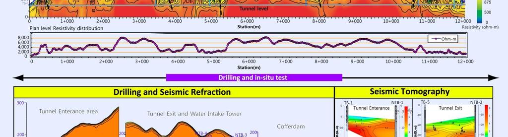
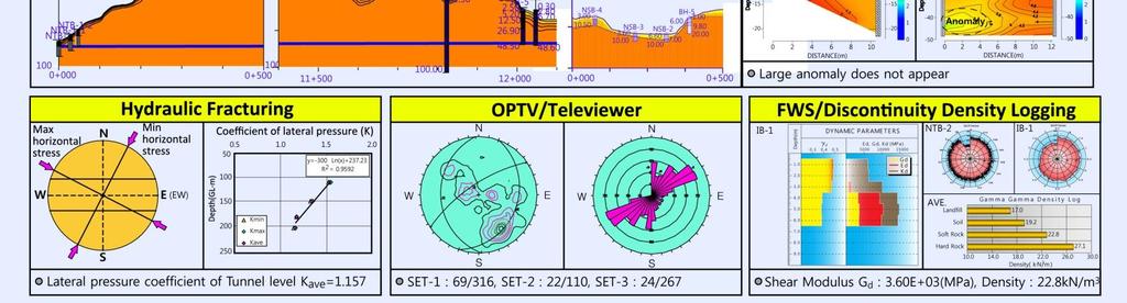
9 WATER TUNNEL PROJECT EXAMPLE


10 CASE HISTORY: DETECTION OF SUBSURFACE OBSTACLES
Chapter 12 Subsurface Exploration
 Page 12 1 Chapter 12 Subsurface Exploration 1. The process of identifying the layers of deposits that underlie a proposed structure and their physical characteristics is generally referred to as (a) subsurface
Site Characterization & Hydrogeophysics
 Site Characterization & Hydrogeophysics (Source: Matthew Becker, California State University) Site Characterization Definition: quantitative description of the hydraulic, geologic, and chemical properties
Mechanical Wave Measurements. Electromagnetic Wave Techniques. Geophysical Methods GEOPHYSICAL SITE CHARACTERIZATION. Mechanical Wave Geophysics
 Geophysical Methods GEOPHYSICAL SITE CHARACTERIZATION Mechanical Wave Measurements Electromagnetic Wave Techniques Mechanical Wave Measurements Crosshole Tests (CHT) Downhole Tests (DHT) Spectral Analysis
LECTURE 10. Module 3 : Field Tests in Rock 3.6 GEOPHYSICAL INVESTIGATION
 LECTURE 10 3.6 GEOPHYSICAL INVESTIGATION In geophysical methods of site investigation, the application of the principles of physics are used to the study of the ground. The soil/rock have different characteristics
Manual on Subsurface Investigations National Highway Institute Publication No. FHWA NHI Federal Highway Administration Washington, DC
 Manual on Subsurface Investigations National Highway Institute Publication No. FHWA NHI-01-031 Federal Highway Administration Washington, DC Geotechnical Site Characterization July 2001 by Paul W. Mayne,
GPR AS A COST EFFECTIVE BEDROCK MAPPING TOOL FOR LARGE AREAS. Abstract
 GPR AS A COST EFFECTIVE BEDROCK MAPPING TOOL FOR LARGE AREAS Dr. Jutta L. Hager, Hager GeoScience, Inc., Waltham, MA Mario Carnevale, Hager GeoScience, Inc., Waltham, MA Abstract Hager GeoScience, Inc.
SITE INVESTIGATION 1
 SITE INVESTIGATION 1 Definition The process of determining the layers of natural soil deposits that will underlie a proposed structure and their physical properties is generally referred to as site investigation.
DOWN-HOLE SEISMIC SURVEY AND VERTICAL ELECTRIC SOUNDINGS RABASKA PROJECT, LÉVIS, QUÉBEC. Presented to :
 DOWN-HOLE SEISMIC SURVEY AND VERTICAL ELECTRIC SOUNDINGS RABASKA PROJECT, LÉVIS, QUÉBEC Presented to : TERRATECH 455, René-Lévesque Blvd. West Montreal, Québec HZ 1Z3 Presented by : GEOPHYSICS GPR INTERNATIONAL
Gotechnical Investigations and Sampling
 Gotechnical Investigations and Sampling Amit Prashant Indian Institute of Technology Gandhinagar Short Course on Geotechnical Investigations for Structural Engineering 12 14 October, 2017 1 Purpose of
Geo-imaging: An Introduction to Engineering Geophysics
 Geo-imaging: An Introduction to Engineering Geophysics Chih-Ping Lin Distinguished Professor, Department of Civil Engineering & Natural Hazard Mitigation Research Center National Chiao Tung University,
Underground Risk Management Course Marina Del Rey, California November, Geotechnical Data Reports. Greg Raines, PE
 Underground Risk Management Course Marina Del Rey, California November, 2018 Geotechnical Data Reports Greg Raines, PE Gregory.Raines@Stantec.com Introduction What is a Geotechnical Data Report? The GDR
SEISMIC SURVEY METHODS
 SEISMIC SURVEY METHODS Seismic methods Seismic surveys are used in geology and geotechnical engineering to: a) define the depth of the bedrock; b) investigate the landslide areas, c) check the structural
Enhanced In-Situ Testing for Geotechnical Site Characterization. Graduate Course CEE 6423
 Enhanced In-Situ Testing for Geotechnical Site Characterization SPT, VST, DMT, PMT, CHT, DHT, CPT Graduate Course CEE 6423 Paul W. Mayne, PhD, P.E. Professor, Geosystems Program Civil & Environmental Engineering
Geophysical Site Investigation (Seismic methods) Amit Prashant Indian Institute of Technology Gandhinagar
 Amit Prashant Indian Institute of Technology Gandhinagar") Geophysical Site Investigation (Seismic methods) Amit Prashant Indian Institute of Technology Gandhinagar Short Course on Geotechnical Aspects of Earthquake Engineering 04 08 March, 2013 Seismic Waves
Geophysical Site Investigation (Seismic methods) Amit Prashant Indian Institute of Technology Gandhinagar Short Course on Geotechnical Aspects of Earthquake Engineering 04 08 March, 2013 Seismic Waves
Instructional Objectives
 GE 6477 DISCONTINUOUS ROCK 8. Fracture Detection Dr. Norbert H. Maerz Missouri University of Science and Technology (573) 341-6714 norbert@mst.edu Instructional Objectives 1. List the advantages and disadvantages
This document downloaded from vulcanhammer.net vulcanhammer.info Chet Aero Marine
 This document downloaded from vulcanhammer.net vulcanhammer.info Chet Aero Marine Don t forget to visit our companion site http://www.vulcanhammer.org Use subject to the terms and conditions of the respective
10. GEOTECHNICAL EXPLORATION PROGRAM
 Geotechnical site investigations should be conducted in multiple phases to obtain data for use during the planning and design of the tunnel system. Geotechnical investigations typically are performed in
Geologging Imagery, Applications and Geological Interpretation. Shea Altadonna 1, Jim Fulton 2, E.I.T.
 Geologging Imagery, Applications and Geological Interpretation Shea Altadonna 1, Jim Fulton 2, E.I.T. 1 Geologist, Advanced Construction Techniques Inc. 1000 N. West St. Ste 1200, Wilmington, DE 19801;
Boreholes. Implementation. Boring. Boreholes may be excavated by one of these methods: 1. Auger Boring 2. Wash Boring 3.
 Implementation Boreholes 1. Auger Boring 2. Wash Boring 3. Rotary Drilling Boring Boreholes may be excavated by one of these methods: 4. Percussion Drilling The right choice of method depends on: Ground
VMS-GeoMil. Background
 Background When using a drilling rig for cone penetration testing, a mechanical clamp can be mounted to the drilling head (by means of a special transition piece). The depth than can be achieved depends
KDOT Geotechnical Manual Edition. Table of Contents
 KDOT Geotechnical Manual 2007 Edition The KDOT Geotechnical Manual is available two volumes. Both volumes are very large electronic (pdf) files which may take several minutes to download. The table of
Lima Project: Seismic Refraction and Resistivity Survey. Alten du Plessis Global Geophysical
 Lima Project: Seismic Refraction and Resistivity Survey Alten du Plessis Global Geophysical Report no 0706/2006 18 December 2006 Lima Project: Seismic Refraction and Resistivity Survey by Alten du Plessis
High Resolution Geophysics: A Better View of the Subsurface. By John Jansen, P.G., Ph.D., Aquifer Science and Technology
 High Resolution Geophysics: A Better View of the Subsurface By John Jansen, P.G., Ph.D., Aquifer Science and Technology Geologist Use Only Part of the Information Available To Them Most Geologist rely
Appendix J. Geological Investigation
 Appendix J Geological Investigation Appendix J Geological Environment Table of Contents Page 1 INTRODUCTION...J-1 1.1 Purpose of the Investigation...J-1 1.2 Scope of the Investigation...J-1 2 METHODO OF
DEVELOPMENT OF EMPIRICAL CORRELATION BETWEEN SHEAR WAVE VELOCITY AND STANDARD PENETRATION RESISTANCE IN SOILS OF CHENNAI CITY
 DEVELOPMENT OF EMPIRICAL CORRELATION BETWEEN SHEAR WAVE VELOCITY AND STANDARD PENETRATION RESISTANCE IN SOILS OF CHENNAI CITY Uma Maheswari R 1, Boominathan A 2 and Dodagoudar G.R 3 1 Research Scholar,
Cone Penetration Testing in Geotechnical Practice
 Cone Penetration Testing in Geotechnical Practice Table Of Contents: LIST OF CONTENTS v (4) PREFACE ix (2) ACKNOWLEDGEMENTS xi (1) SYMBOL LIST xii (4) CONVERSION FACTORS xvi (6) GLOSSARY xxii 1. INTRODUCTION
NEW DOWN-HOLE PENETROMETER (DHP-CIGMAT) FOR CONSTRUCTION APPLICATIONS
 FOR CONSTRUCTION APPLICATIONS") NEW DOWN-HOLE PENETROMETER (DHP-CIGMAT) FOR CONSTRUCTION APPLICATIONS 1 2 C. Vipulanandan 1, Ph.D., M. ASCE and Omer F. Usluogullari 2 Chairman, Professor, Director of Center for Innovative Grouting Materials
NEW DOWN-HOLE PENETROMETER (DHP-CIGMAT) FOR CONSTRUCTION APPLICATIONS 1 2 C. Vipulanandan 1, Ph.D., M. ASCE and Omer F. Usluogullari 2 Chairman, Professor, Director of Center for Innovative Grouting Materials
Applied Geophysics for Environmental Site Characterization and Remediation
 Applied Geophysics for Environmental Site Characterization and Remediation MSECA Webinar September 24, 2015 John Mundell, P.E., L.P.G. Ryan Brumbaugh, L.P.G. MUNDELL & ASSOCIATES, INC. Webinar Objective
GEOTECHNICAL ENGINEERING II. Subject Code : 06CV64 Internal Assessment Marks : 25 PART A UNIT 1
 GEOTECHNICAL ENGINEERING II Subject Code : 06CV64 Internal Assessment Marks : 25 PART A UNIT 1 1. SUBSURFACE EXPLORATION 1.1 Importance, Exploration Program 1.2 Methods of exploration, Boring, Sounding
ambiguity in earth sciences IESO Geophysics Section Eddy hartantyo, Lab Geofisika FMIPA UGM
 ambiguity in earth sciences IESO Geophysics Section Eddy hartantyo, Lab Geofisika FMIPA UGM Pelatihan Tahap II IESO Teknik Geologi UGM Februari 2009 1 Introduction Photos from http://www.eegs.org/whatis/
A Comparison of Four Geophysical Methods for Determining the Shear Wave Velocity of Soils
 A Comparison of Four Geophysical Methods for Determining the Shear Wave Velocity of Soils Neil Anderson 1, Thanop Thitimakorn 1, David Hoffman 2, Richard Stephenson 2, Ronaldo Luna 2 Geological Sciences
7. Foundation and Slope Stability
 The Asian Nuclear Safety Network 7. Foundation and Slope Stability (SER 2.5.4 & 2.5.5) Taek-Mo SHIM k147stm@kins.re.kr Korea Institute of Nuclear Safety Structural Systems and Site Evaluation Department
Source Wave Design for Downhole Seismic Testing
 Source Wave Design for Downhole Seismic Testing Downhole seismic testing (DST) has become a very popular site characterizing tool among geotechnical engineers. DST methods, such as the Seismic Cone Penetration
ENCE 3610 Soil Mechanics. Site Exploration and Characterisation Field Exploration Methods
 ENCE 3610 Soil Mechanics Site Exploration and Characterisation Field Exploration Methods Geotechnical Involvement in Project Phases Planning Design Alternatives Preparation of Detailed Plans Final Design
INNOVATIVE TECHNIQUES TO INVESTIGATE CONTAMINATION IN FRACTURED BEDROCK
 INNOVATIVE TECHNIQUES TO INVESTIGATE CONTAMINATION IN FRACTURED BEDROCK Abstract Christopher Gaule 1, Kenneth Goldstein 2, Grant Anderson 3 Watervliet Arsenal, located in Watervliet, New York, is the oldest
A scale/resolution problem
 Near Surface 2005 September 4-7, 2005, Palermo Italy WORKSHOP on Hydrogeophysics a tool for sustainable use of groundwater resources Integrated Seismic and GPR characterization of fractured rocks Pipan,
The UK GeoEnergy Test Bed Ceri J Vincent British Geological Survey
 The UK GeoEnergy Test Bed Ceri J Vincent British Geological Survey Thanks to Matthew Hall (GTB Theme Lead for G ERA), Phil Meldrum, Russell Swift, Oliver Kuras, Richard Luckett, Andrew Butcher, Jonathan
Module 1 : Site Exploration and Geotechnical Investigation
 Objectives In this section you will learn the following Displacement borings Wash boring Auger boring Rotary drilling Percussion drilling Continuous sampling Boring methods of exploration The boring methods
TABLE OF CONTENTS CHAPTER TITLE PAGE TITLE PAGE DECLARATION DEDIDATION ACKNOWLEDGEMENTS ABSTRACT ABSTRAK
 TABLE OF CONTENTS CHAPTER TITLE PAGE TITLE PAGE DECLARATION DEDIDATION ACKNOWLEDGEMENTS ABSTRACT ABSTRAK TABLE OF CONTENTS LIST OF TABLE LIST OF FIGURES LIST OF SYMBOLS LIST OF APENDICES i ii iii iv v
Site Investigations and Geotechnical Risk For Underground Construction Greg Raines, PE
 August 14, 2017 Site Investigations and Geotechnical Risk For Underground Construction Greg Raines, PE Gregory.Raines@Stantec.com Develop Preliminary Geologic / Geotech Conceptual Model for the Project
Geophysics for Environmental and Geotechnical Applications
 Geophysics for Environmental and Geotechnical Applications Dr. Katherine Grote University of Wisconsin Eau Claire Why Use Geophysics? Improve the quality of site characterization (higher resolution and
An Introduction to Geophysical Exploration
 An Introduction to Geophysical Exploration Philip Kearey Department of Earth Sciences University of Bristol Michael Brooks Ty Newydd, City Near Cowbridge Vale of Glamorgan Ian Hill Department of Geology
IN SITU TESTING IN GEOMECHANICS. Fernando Schnaid Universidade Federal do Rio Grande do Sul
 IN SITU TESTING IN GEOMECHANICS Fernando Schnaid Universidade Federal do Rio Grande do Sul Patologia das Fundações Geotechnical investigation British Practice (Weltman & Head,1981): Sufficient finance
HOW. HOW vehicle mounted units portable units also available. HOW, WHEN & WHY to Geophysically Log in S.I.?
 HOW, WHEN & WHY to Geophysically Log in S.I.? by Kim Beesley HOW HOW vehicle mounted units portable units also available Access to borehole Depth of borehole sump / rat -hole? 1 HOW? - subject to borehole
The process of determining the layers of natural soil deposits that will underlie a proposed structure and their physical properties is generally
 The process of determining the layers of natural soil deposits that will underlie a proposed structure and their physical properties is generally referred to as sub surface investigation 2 1 For proper
Prof. Dr.-Ing. Martin Achmus Institute of Soil Mechanics, Foundation Engineering and Waterpower Engineering. Offshore subsoil investigations
 Prof. Dr.-Ing. Martin Achmus Institute of Soil Mechanics, Foundation Engineering and Waterpower Engineering Offshore subsoil investigations Addis Ababa, September 2010 Offshore subsoil investigations Presentation
NSE 3.7. SEG/Houston 2005 Annual Meeting 1121
 Julian Ivanov,* Richard D. Miller, Kansas Geological Survey, The University of Kansas; Robert F. Ballard, Jr., Joseph B. Dunbar, U.S. Army Engineer Research and Development Center (ERDC) Geotechnical and
International Journal of Advanced and Applied Sciences
 International Journal of Advanced and Applied Sciences, 3(5) 2016, Pages: 65 72 Contents lists available at Science Gate International Journal of Advanced and Applied Sciences Journal homepage: http://www.science
Site investigation results versus tunnelling conditions a study with emphasis on water leakage based on Norwegian cases
 Site investigation results versus tunnelling conditions a study with emphasis on water leakage based on Norwegian cases Kristin H. Holmøy, Bjørn Nilsen Norwegian University of Science and Technology, Department
Soil Behaviour in Earthquake Geotechnics
 Soil Behaviour in Earthquake Geotechnics KENJI ISHIHARA Department of Civil Engineering Science University of Tokyo This publication was supported by a generous donation from the Daido Life Foundation
Geophysical Investigation of Ground Water Using Vertical Electrical Sounding and Seismic Refraction Methods
 International Journal of Petroleum and Petrochemical Engineering (IJPPE) Volume 2, Issue 1, 2016, PP 6-11 ISSN 2454-7980 (Online) www.arcjournals.org Geophysical Investigation of Ground Water Using Vertical
Integration of Seismic Refraction and 2D Electrical Resistivity in Locating Geological Contact
 Open Journal of Geology, 2013, 3, 7-12 doi:10.4236/ojg.2013.32b002 Published Online April 2013 (http://www.scirp.org/journal/ojg) Integration of Seismic Refraction and 2D Electrical Resistivity in Locating
Conventional Field Testing & Issues (SPT, CPT, DCPT, Geophysical methods)
") Conventional Field Testing & Issues (SPT, CPT, DCPT, Geophysical methods) Ajanta Sachan Assistant Professor Civil Engineering IIT Gandhinagar Conventional Field Testing 1 Field Test: In-situ shear strength
Conventional Field Testing & Issues (SPT, CPT, DCPT, Geophysical methods) Ajanta Sachan Assistant Professor Civil Engineering IIT Gandhinagar Conventional Field Testing 1 Field Test: In-situ shear strength
University of Wyoming Near-Surface Geophysical Instrument Center & Wyoming Center for Environmental Hydrology and Geophysics
 University of Wyoming Near-Surface Geophysical Instrument Center & Wyoming Center for Environmental Hydrology and Geophysics UWNSG & WyCEHG Groundwater Studies on the Brule Formation near Pine Bluffs,
Groundwater Sustainability at Wadi Al Bih Dam, Ras El Khaimah, United Arab Emirates (UAE) using Geophysical methods
 using Geophysical methods") Groundwater Sustainability at Wadi Al Bih Dam, Ras El Khaimah, United Arab Emirates (UAE) using Geophysical methods Ahmed Murad, Amir Gabr, Saber Mahmoud, Hasan Arman & Abdulla Al Dhuhoori Geology Department
Groundwater Sustainability at Wadi Al Bih Dam, Ras El Khaimah, United Arab Emirates (UAE) using Geophysical methods Ahmed Murad, Amir Gabr, Saber Mahmoud, Hasan Arman & Abdulla Al Dhuhoori Geology Department
AVON DAM MONITORING BOREHOLES REPORT
 AVON DAM MONITORING BOREHOLES REPORT September 2015 Melinda Smart Supervisor Brownfields Exploration Energy and Engineering S2313 AND S2314 MONITORING BOREHOLES Avon Dam Hole 1 (S2313) and Avon Dam Hole
Geophysical Exploration in Water Resources Assessment. John Mundell, P.E., L.P.G., P.G. Ryan Brumbaugh, L.P.G. Mundell & Associates, Inc.
 Geophysical Exploration in Water Resources Assessment John Mundell, P.E., L.P.G., P.G. Ryan Brumbaugh, L.P.G. Mundell & Associates, Inc. Presentation Objective Introduce the use of geophysical survey methods
Engineering Geophysical Application to Mine Subsidence Risk Assessment
 Engineering Geophysical Application to Mine Subsidence Risk Assessment By: Kanaan Hanna, Sr. Mining Engineer Steve Hodges, Sr. Geophysicist Jim Pfeiffer, Sr. Geophysicist Dr. Keith Heasley, Professor West
MEASUREMENT OF HYDRAULICALLY ACTIVATED SUBSURFACE FRACTURE SYSTEM IN GEOTHERMAL RESERVOIR BY USING ACOUSTIC EMISSION MULTIPLET-CLUSTERING ANALYSIS
 MEASUREMENT OF HYDRAULICALLY ACTIVATED SUBSURFACE FRACTURE SYSTEM IN GEOTHERMAL RESERVOIR BY USING ACOUSTIC EMISSION MULTIPLET-CLUSTERING ANALYSIS HIROKAZU MORIYA 1, HIROAKI NIITSUMA 1 and ROY BARIA 2
GPR surveys at Nõmmküla Detection of underground water routes
 GPR surveys at Nõmmküla 2009 Detection of underground water routes Tomi Herronen & Timo Saarenketo 2009 1. Introduction The purpose of this survey was to locate possible underground water routes (rivers)
IN SITU TESTING TECHNOLOGY FOR FOUNDATION & EARTHQUAKE ENGINEERING. Wesley Spang, Ph.D., P.E. AGRA Earth & Environmental, Inc.
 IN SITU TESTING TECHNOLOGY FOR FOUNDATION & EARTHQUAKE ENGINEERING Wesley Spang, Ph.D., P.E. AGRA Earth & Environmental, Inc. Portland, Oregon In situ testing of soil, which essentially consists of evaluating
Finding Large Capacity Groundwater Supplies for Irrigation
 Finding Large Capacity Groundwater Supplies for Irrigation December 14, 2012 Presented by: Michael L. Chapman, Jr., PG Irrigation Well Site Evaluation Background Investigation Identify Hydrogeologic Conditions
Role of lithological layering on spatial variation of natural and induced fractures in hydraulic fracture stimulation
 Role of lithological layering on spatial variation of natural and induced fractures in hydraulic fracture stimulation Vincent Roche *, Department of Physics, University of Alberta, Edmonton roche@ualberta.ca
GEOTECHNICAL SITE CHARACTERIZATION
 GEOTECHNICAL SITE CHARACTERIZATION Neil Anderson, Ph.D. Professor of Geology and Geophysics Richard W. Stephenson, P.E., Ph.D. Professor of Civil, Architectural and Environmental Engineering University
ERTH2020 Introduction to Geophysics The Seismic Method. 1. Basic Concepts in Seismology. 1.1 Seismic Wave Types
 ERTH2020 Introduction to Geophysics The Seismic Method 1. Basic Concepts in Seismology 1.1 Seismic Wave Types Existence of different wave types The existence of different seismic wave types can be understood
Interpretation of Pile Integrity Test (PIT) Results
 Results") Annual Transactions of IESL, pp. 78-84, 26 The Institution of Engineers, Sri Lanka Interpretation of Pile Integrity Test (PIT) Results H. S. Thilakasiri Abstract: A defect present in a pile will severely
Annual Transactions of IESL, pp. 78-84, 26 The Institution of Engineers, Sri Lanka Interpretation of Pile Integrity Test (PIT) Results H. S. Thilakasiri Abstract: A defect present in a pile will severely
 www.novotechsoftware.com The standard penetration test (SPT) is an in-situ dynamic penetration test designed to provide information on the geotechnical engineering properties of soil. The test procedure
SOIL INVESTIGATION USING MULTICHANNEL ANALYSIS OF SURFACE WAVE (MASW) AND BOREHOLE
 AND BOREHOLE") SOIL INVESTIGATION USING MULTICHANNEL ANALYSIS OF SURFACE WAVE (MASW) AND BOREHOLE Aziman Madun 1,2, Muhammad Ersyad Ahmad Supa at 1, Saiful Azhar Ahmad Tajudin 1,2, Mohd Hazreek Zainalabidin 1,2, Salina
SOIL INVESTIGATION USING MULTICHANNEL ANALYSIS OF SURFACE WAVE (MASW) AND BOREHOLE Aziman Madun 1,2, Muhammad Ersyad Ahmad Supa at 1, Saiful Azhar Ahmad Tajudin 1,2, Mohd Hazreek Zainalabidin 1,2, Salina
Patterns in Geophysical Data and Models
 Patterns in Geophysical Data and Models Jens Tronicke Angewandte Geophysik Institut für Geowissenschaften Universität Potsdam jens@geo.uni-potsdam.de Near-surface geophysics Using geophysical tools to
Geotechnical data from optical and acoustic televiewer surveys
 Geotechnical data from optical and acoustic televiewer surveys by Farrin De Fredrick MAusIMM, Senior Geotechnical Engineer; Ta Nguyen AIG, Geotechnical Engineer; Clive Seymour MAusIMM, Principal; and Gary
Predicting rock conditions ahead of the face
 Predicting rock conditions ahead of the face Dr Thomas Dickmann, Product Manager Geophysics, Amberg Technologies AG Seismic methods of predicting rock conditions ahead of the tunnel face have developed
CENTER FOR INFRASTRUCTURE ENGINEERING STUDIES
 1 CENTER FOR INFRASTRUCTURE ENGINEERING STUDIES Acquisition of an Engineering Seismograph By Dr. Neil Anderson UTC RE116 University Transportation Center Program at The University of Missouri-Rolla 2 Disclaimer
Geophysics for Land Development
 Geophysics for Land Development About Us Whatever your area of interest GBGMAPS can provide advanced subsurface and structural geophysical solutions to add value to your product. Mining and infrastructure
Correlation Between P-wave Velocity and Strength Index for Shale to Predict Uniaxial Compressive Strength Value
 Correlation Between P-wave Velocity and Strength Index for Shale to Predict Uniaxial Compressive Strength Value H. Awang 1, N. R. Ahmad Rashidi 1, M. Yusof 1,*, and K. Mohammad 2 1 Institute for Infrastructure
Hazard Mapping Along the Dead Sea Shoreline
 FIG Working Week in Marrakech, Morocco 18-22 May 2011 Hazard Mapping Along the Dead Sea Shoreline Rami Al-Ruzouq, Abdullah Al-Zuobi, AbdEl-Rahman Abueladas, Emad Akkawi Department of Surveying and Geomatics
Geotechnical & Mining Engineering Services
 Geotechnical & Mining Engineering Services Southwest Research Institute San Antonio, Texas A s an independent, nonprofit research and development organization, Southwest Research Institute (SwRI ) uses
Department of National Defence B-Jetty Reconstruction
 Department of National Defence B-Jetty Reconstruction CFB Esquimalt, BC Presented by: Stantec & Golder Associates February 2, 2016 Agenda 1 B-Jetty Project Background 2 Distinguishing Project Features
STUDY OF ENGINEERING PROPERTIES BY USING DOWNHOLE METHOD FOR SOUTH BAGHDAD AREA IN IRAQ
 International Journal of Civil Engineering and Technology (IJCIET) olume 9, Issue 9, September 0, pp. 0 0, Article ID: IJCIET_09_09_0 Available online at http://www.iaeme.com/ijciet/issues.asp?jtype=ijciet&type=9&itype=9
Geological Mapping using Geophysics
 Geological Mapping using Geophysics Pugin, A.J.M. and T.H. Larson Illinois State Geological Survey, 615 E Peabody Dr., Champaign, IL 61820; E-mail: A.J.M. Pugin at pugin@isgs.uiuc.edu Mapping Techniques.
An Introduction to Field Explorations for Foundations
 An Introduction to Field Explorations for Foundations J. Paul Guyer, P.E., R.A. Paul Guyer is a registered mechanical engineer, civil engineer, fire protection engineer and architect with over 35 years
Seismoelectric Ground-flow DC-4500 Locator
 Seismoelectric Ground-flow DC-4500 Locator Introduction The seismoelectric survey is a new technology combined the electro kinetic potential method and geophysical technology. It is applied directly to
Does the SDCP need inputs from geology?
 The British Geological Survey s Experience and Expertise in Supporting Projects such as the Sirte Depression Connection Project David Ovadia Director of International Kingsley Dunham Centre Keyworth Nottingham
The Mine Geostress Testing Methods and Design
 Open Journal of Geology, 2014, 4, 622-626 Published Online December 2014 in SciRes. http://www.scirp.org/journal/ojg http://dx.doi.org/10.4236/ojg.2014.412046 The Mine Geostress Testing Methods and Design
Project S4: ITALIAN STRONG MOTION DATA BASE. Deliverable # D3. Definition of the standard format to prepare descriptive monographs of ITACA stations
 Agreement INGV-DPC 2007-2009 Project S4: ITALIAN STRONG MOTION DATA BASE Responsibles: Francesca Pacor, INGV Milano Pavia and Roberto Paolucci, Politecnico Milano http://esse4.mi.ingv.it Deliverable #
GEOPHYSICAL INVESTIGATIONS FOR IDENTIFICATION OF SUBSURFACE. Arindam Dey Assistant Professor Department of Civil Engineering IIT Guwahati
 GEOPHYSICAL INVESTIGATIONS FOR IDENTIFICATION OF SUBSURFACE STRATIGRAPHY AT IIT GUWAHATI Arindam Dey Assistant Professor Department of Civil Engineering IIT Guwahati What is MASW NDT Procedures SRS, GPR,
Hybrid Seismic Survey on the Gamanjunni Rockslide Site
 Hybrid Seismic Survey on the Gamanjunni Rockslide Site by Walter Frei; info@geoexpert.ch NVE Workshop / Oslo 30.-31. January 2017 (1) Pictorial Introduction to Hybrid Seismic Profiling (2) Recommended
 UNIT I SITE INVESTIGATION AND SELECTION OF FOUNDATION Types of boring 1.Displacement borings It is combined method of sampling & boring operation. Closed bottom sampler, slit cup, or piston type is forced
IAEA SAFETY STANDARDS Geotechnical Aspects of Site Evaluation and Foundations in NPPs, NS-G-3.6
 IAEA SAFETY STANDARDS Geotechnical Aspects of Site Evaluation and Foundations in NPPs, NS-G-3.6 Regional Workshop on Volcanic, Seismic, and Tsunami Hazard Assessment Related to NPP Siting Activities and
EN Eurocode 7. Section 3 Geotechnical Data Section 6 Spread Foundations. Trevor L.L. Orr Trinity College Dublin Ireland.
 EN 1997 1: Sections 3 and 6 Your logo Brussels, 18-20 February 2008 Dissemination of information workshop 1 EN 1997-1 Eurocode 7 Section 3 Geotechnical Data Section 6 Spread Foundations Trevor L.L. Orr
Chapter 3 SUBSOIL EXPLORATION. Omitted parts: Sections & 3.24, 3.25 Examples 3.3, 3.4,3.5
 Chapter 3 SUBSOIL EXPLORATION Omitted parts: Sections 3.2-3.10 & 3.24, 3.25 Examples 3.3, 3.4,3.5 GENERAL OBSERVATION Soil does not posses a unique or linear stress-strain relationship. Soil behavior depends
Chapter 1 Introduction
 Chapter 1 Introduction 1.1 Statement of the Problem Engineering properties of geomaterials are very important for civil engineers because almost everything we build - tunnels, bridges, dams and others
ontribution of Geotechnical and Rock echanics design to vertical shaft nking and design
 ontribution of Geotechnical and Rock echanics design to vertical shaft nking and design CONTENTS Geological and Geotechnical investigations Pre-sink Examples of Pre-sinking in soft soils Ancillary excavations
Geotechnical Aspects of the Seismic Update to the ODOT Bridge Design Manual. Stuart Edwards, P.E Geotechnical Consultant Workshop
 Geotechnical Aspects of the Seismic Update to the ODOT Bridge Design Manual Stuart Edwards, P.E. 2017 Geotechnical Consultant Workshop Changes Role of Geotechnical Engineer Background Methodology Worked
2-D Resistivity Study: The Horizontal Resolution Improvement by Introducing the Enhancing Horizontal Resolution (EHR) Technique
 Technique") Open Journal of Geology, 213, 3, 1-6 doi:1.4236/ojg.213.32b1 Published Online April 213 (http://www.scirp.org/journal/ojg) 2-D Resistivity Study: The Horizontal Resolution Improvement by Introducing the
Open Journal of Geology, 213, 3, 1-6 doi:1.4236/ojg.213.32b1 Published Online April 213 (http://www.scirp.org/journal/ojg) 2-D Resistivity Study: The Horizontal Resolution Improvement by Introducing the
Applying Seismic Refraction Method in Depicting Geological Contact at Bukit Bunuh, Lenggong, Perak, Malaysia
 2012 International Conference on Geological and Environmental Sciences IPCBEE vol.3 6(2012) (2012)IACSIT Press, Singapoore Applying Seismic Refraction Method in Depicting Geological Contact at Bukit Bunuh,
EVALUATION OF DYNAMIC METHODS FOR EARTHWORK ASSESSMENT
 Vol. 11, Issue 1/, 38-44 DOI:./cee--000 EVALUATION OF DYNAMIC METHODS FOR EARTHWORK ASSESSMENT Jozef VLČEK 1,*, Dominika ĎUREKOVÁ 2, Katarína ZGÚTOVÁ 2 1 Department of Geotechnics, Faculty of Civil Engineering,
Introduction to Formation Evaluation Abiodun Matthew Amao
 Introduction to Formation Evaluation By Abiodun Matthew Amao Monday, September 09, 2013 Well Logging PGE 492 1 Lecture Outline What is formation evaluation? Why do we evaluate formation? What do we evaluate?
Acquisition and preliminary analysis of the Castle Mountain shallow VSP dataset
 Castle Mountain shallow VSP Acquisition and preliminary analysis of the Castle Mountain shallow VSP dataset Joe Wong, Henry C. Bland, Kevin W. Hall and Robert R. Stewart ABSTRACT As part of the 2006 geophysics
Standard Test Method for Determination of the In-Situ Stress in Rock Using the Hydraulic Fracturing Method 1
 Designation: D 4645 04 Standard Test Method for Determination of the In-Situ Stress in Rock Using the Hydraulic Fracturing Method 1 This standard is issued under the fixed designation D 4645; the number