patersongroup Design for Earthquakes Consulting Engineers May 19, 2016 File: PG3733-LET.01
|
|
|
- Annice Stewart
- 5 years ago
- Views:
Transcription
1 patersongroup May 19, 2016 File: PG3733-LET.01 Hydro Ottawa Limited c/o Cresa Toronto 170 University Avenue, Suite 1 Toronto, Ontario M5H 3B3 Attention: Ms. Barbara Wright Consulting Engineers 154 Colonnade Road South Ottawa, Ontario K2E 7J5 Tel: (613) Fax: (613) Geotechnical Engineering Environmental Engineering Archaeological Studies Hydrogeology Geological Engineering Materials Testing Building Science Archaeological Services Subject: Seismic Shear Wave Velocity Testing Results Proposed Hydro Ottawa Facility 201 Dibblee Road - Ottawa Dear Sir, Further to your request, Paterson Group (Paterson) completed a site specific shear wave velocity test to determine the seismic site classification for the proposed building located at the aforementioned site. Design for Earthquakes Shear wave velocity testing was completed for the subject site to accurately determine the applicable seismic site classification for the proposed building from Table A of the Ontario Building Code The shear wave velocity testing was completed by Paterson personnel. The results of the shear wave velocity test are attached to the present report. Field Program The seismic array testing location was placed within the central portion of the subject site in a north to south direction as presented in Drawing PG Seismic Array Plan attached to the present report. Paterson field personnel placed 24 horizontal 4.5 Hz. geophones mounted to the surface by means of two 75 mm ground spikes attached to the geophone land case. The geophones were spaced at 1 m intervals and connected by a geophone spread cable to a Geode 24 Channel seismograph. Ottawa Kingston North Bay
2 Ms. Barbara Wright Page 2 File: PG3733-LET.01 The seismograph was also connected to a computer laptop and a hammer trigger switch attached to a 12 pound dead blow hammer. The hammer trigger switch sends a start signal to the seismograph. The hammer is used to strike an I-Beam seated into the ground surface, which creates a polarized shear wave. The hammer shots are repeated between five to ten times at each shot location to improve signal to noise ratio. The shot locations are also completed in forward and reverse directions (i.e.- striking both sides of the I-Beam seated parallel to the geophone array). The shot locations are located at 15 m, 1.5 m and 1 m away from the first and last geophone and at the centre of the seismic array. The methods of testing completed by Paterson are guided by the standard testing procedures used by the expert seismologists at Carleton University and Geological Survey of Canada (GSC). Data Processing and Interpretation Interpretation for the shear wave velocity results were completed by Paterson personnel. Shear wave velocity measurement was made using reflection/refraction methods. The interpretation is performed by recovering arrival times from direct and refracted waves. The interpretation is repeated at each shot location to provide an average shear wave velocity, Vs 30, of the upper 30 m profile, immediately below the building s foundation. The layer intercept times, velocities from different layers and critical distances are interpreted from the shear wave records to compute the bedrock depth at each location. The bedrock velocity was interpreted using the main refractor wave velocity, which is considered a conservative estimate of the bedrock velocity due to the increasing quality of the bedrock with depth. It should be noted that as bedrock quality increases, the bedrock shear wave velocity also increases. It is anticipated that the proposed building will be founded directly on bedrock. Based on our testing results, the bedrock shear wave velocity is 2,250 m/s. patersongroup
 2012, as presented below.")
3 Ms. Barbara Wright Page 3 File: PG3733-LET.01 The Vs 30 was calculated using the standard equation for average shear wave velocity calculation from the Ontario Building Code (OBC) 2012, as presented below. Conclusion Based on the results of the seismic testing, the average shear wave velocity, Vs 30, for foundations placed on bedrock is 2,250 m/s. Therefore, a Site Class A is applicable for design of the proposed building founded on bedrock, as per Table A of the OBC The soils underlying the subject site are not susceptible to liquefaction. We trust that this information satisfies your requirements. Best Regards, Paterson Group Inc. Richard Groniger, C. Tech. David J. Gilbert, P.Eng. Attachments Soil Profile and Test Data Sheets Figure 1 and Figure 2 - Seismic Shear Wave Velocity Profiles Drawing PG Seismic Array Location Plan Report Distribution Cresa Toronto (1 digital copy) Paterson Group (1 copy) patersongroup
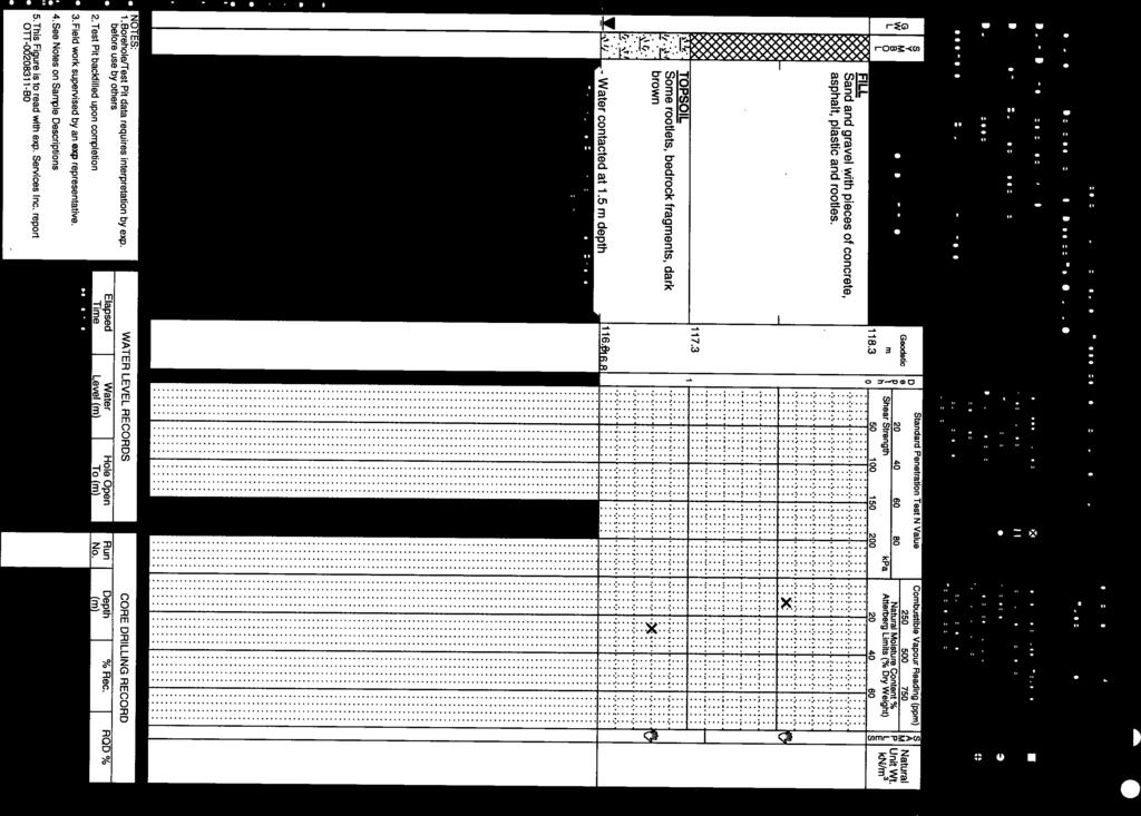
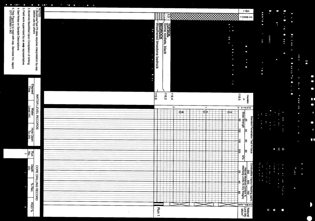
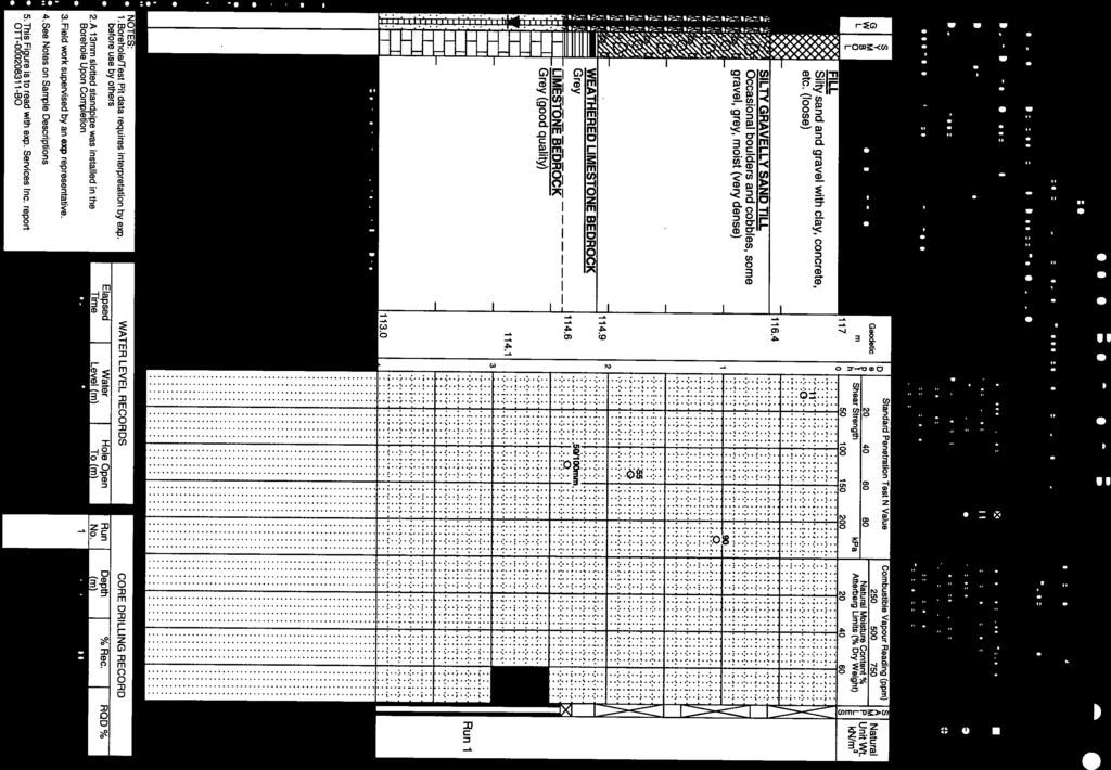
4 patersongroup 154 Colonnade Road South, Ottawa, Ontario K2E 7J5 DATUM REMARKS Consulting Engineers SOIL PROFILE AND TEST DATA Geotechnical Investigation Prop. Hydro Ottawa Facility Dibblee Road Ottawa, Ontario TBM - Ground surface referenced to the top of culvert located at site entrance. A geodetic elevation of 117.9m was interpolated based on available survey plan. FILE NO. HOLE NO. PG3733 BORINGS BY CME 75 Power Auger DATE November 6, 2015 BH 1 SOIL DESCRIPTION GROUND SURFACE FILL: Dark brown silty sand with gravel, some cobbles, trace brick and concrete - roots noted in upper 400mm 1.70 STRATA PLOT TYPE AU SS SS SAMPLE NUMBER % RECOVERY N VALUE or RQD DEPTH (m) ELEV. (m) Pen. Resist. Blows/0.3m 50 mm Dia. Cone Water Content % Monitoring Well Construction GLACIAL TILL: Brown silty sand with some gravel, cobbles and boulders SS SS SS RC BEDROCK: Grey limestone, shale partings throughout RC RC RC End of Borehole m-Nov. 13, 2015) Shear Strength (kpa) Undisturbed Remoulded
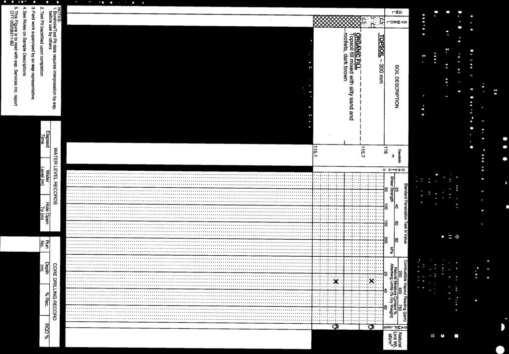
5 patersongroup 154 Colonnade Road South, Ottawa, Ontario K2E 7J5 DATUM TBM - Ground surface referenced to the top of culvert located at site entrance. A geodetic elevation of 117.9m was interpolated based on available survey plan. PG3733 REMARKS HOLE NO. BORINGS BY DATE BH 2 CME 75 Power Auger Consulting Engineers SOIL PROFILE AND TEST DATA Geotechnical Investigation Prop. Hydro Ottawa Facility Dibblee Road Ottawa, Ontario November 6, 2015 FILE NO. SOIL DESCRIPTION GROUND SURFACE TOPSOIL 0.30 STRATA PLOT TYPE AU SAMPLE NUMBER % RECOVERY 1 N VALUE or RQD DEPTH (m) 0 ELEV. (m) Pen. Resist. Blows/0.3m 50 mm Dia. Cone Water Content % Monitoring Well Construction GLACIAL TILL: Brown silty sand, some cobbles and boulders SS SS SS SS RC BEDROCK: Grey limestone, shale partings throughout RC RC RC End of Borehole m-Nov. 13, 2015) Shear Strength (kpa) Undisturbed Remoulded
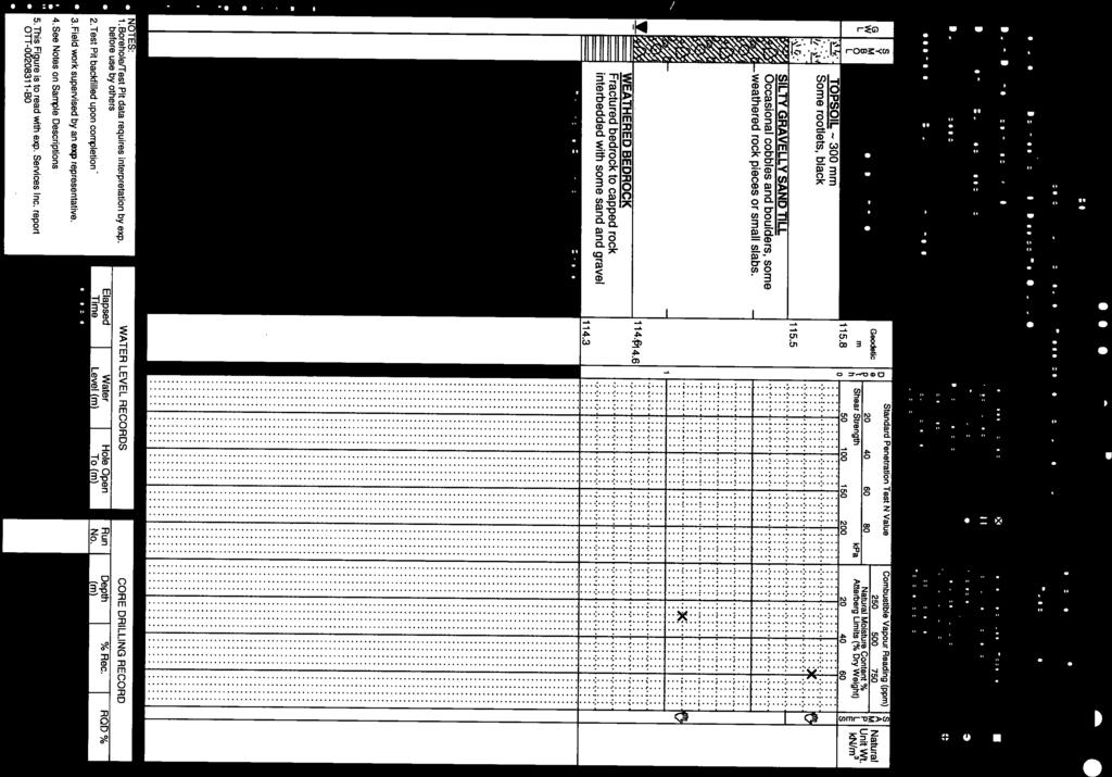
6 patersongroup 154 Colonnade Road South, Ottawa, Ontario K2E 7J5 DATUM REMARKS BORINGS BY TBM - Ground surface referenced to the top of culvert located at site entrance. A geodetic elevation of 117.9m was interpolated based on available survey plan. CME 75 Power Auger Consulting Engineers DATE SOIL PROFILE AND TEST DATA Geotechnical Investigation Prop. Hydro Ottawa Facility Dibblee Road Ottawa, Ontario November 6, 2015 FILE NO. HOLE NO. PG3733 BH 3 GROUND SURFACE TOPSOIL SOIL DESCRIPTION 0.69 STRATA PLOT TYPE AU SS RC SAMPLE NUMBER % RECOVERY N VALUE or RQD DEPTH (m) 0 1 ELEV. (m) Pen. Resist. Blows/0.3m 50 mm Dia. Cone Water Content % Monitoring Well Construction RC RC BEDROCK: Grey limestone, shale partings throughout RC RC End of Borehole m-Nov. 13, 2015) Shear Strength (kpa) Undisturbed Remoulded
7 SYMBOLS AND TERMS SOIL DESCRIPTION Behavioural properties, such as structure and strength, take precedence over particle gradation in describing soils. Terminology describing soil structure are as follows: Desiccated - having visible signs of weathering by oxidation of clay minerals, shrinkage cracks, etc. Fissured - having cracks, and hence a blocky structure. Varved - composed of regular alternating layers of silt and clay. Stratified - composed of alternating layers of different soil types, e.g. silt and sand or silt and clay. Well-Graded - Having wide range in grain sizes and substantial amounts of all intermediate particle sizes (see Grain Size Distribution). Uniformly-Graded - Predominantly of one grain size (see Grain Size Distribution). The standard terminology to describe the strength of cohesionless soils is the relative density, usually inferred from the results of the Standard Penetration Test (SPT) N value. The SPT N value is the number of blows of a 63.5 kg hammer, falling 760 mm, required to drive a 51 mm O.D. split spoon sampler 300 mm into the soil after an initial penetration of 150 mm. Relative Density N Value Relative Density % Very Loose <4 <15 Loose Compact Dense Very Dense >50 >85 The standard terminology to describe the strength of cohesive soils is the consistency, which is based on the undisturbed undrained shear strength as measured by the in situ or laboratory vane tests, penetrometer tests, unconfined compression tests, or occasionally by Standard Penetration Tests. Consistency Undrained Shear Strength (kpa) N Value Very Soft <12 <2 Soft Firm Stiff Very Stiff Hard >200 >30
8 SYMBOLS AND TERMS (continued) SOIL DESCRIPTION (continued) Cohesive soils can also be classified according to their sensitivity. The sensitivity is the ratio between the undisturbed undrained shear strength and the remoulded undrained shear strength of the soil. Terminology used for describing soil strata based upon texture, or the proportion of individual particle sizes present is provided on the Textural Soil Classification Chart at the end of this information package. ROCK DESCRIPTION The structural description of the bedrock mass is based on the Rock Quality Designation (RQD). The RQD classification is based on a modified core recovery percentage in which all pieces of sound core over mm long are counted as recovery. The smaller pieces are considered to be a result of closelyspaced discontinuities (resulting from shearing, jointing, faulting, or weathering) in the rock mass and are not counted. RQD is ideally determined from NXL size core. However, it can be used on smaller core sizes, such as BX, if the bulk of the fractures caused by drilling stresses (called mechanical breaks ) are easily distinguishable from the normal in situ fractures. RQD % ROCK QUALITY 90- Excellent, intact, very sound Good, massive, moderately jointed or sound Fair, blocky and seamy, fractured Poor, shattered and very seamy or blocky, severely fractured 0-25 Very poor, crushed, very severely fractured SAMPLE TYPES SS - Split spoon sample (obtained in conjunction with the performing of the Standard Penetration Test (SPT)) TW - Thin wall tube or Shelby tube PS - Piston sample AU - Auger sample or bulk sample WS - Wash sample RC - Rock core sample (Core bit size AXT, BXL, etc.). Rock core samples are obtained with the use of standard diamond drilling bits.
9 SYMBOLS AND TERMS (continued) GRAIN SIZE DISTRIBUTION MC% - Natural moisture content or water content of sample, % LL - Liquid Limit, % (water content above which soil behaves as a liquid) PL - Plastic limit, % (water content above which soil behaves plastically) PI - Plasticity index, % (difference between LL and PL) Dxx - Grain size which xx% of the soil, by weight, is of finer grain sizes These grain size descriptions are not used below mm grain size D10 - Grain size at which 10% of the soil is finer (effective grain size) D60 - Grain size at which 60% of the soil is finer Cc - Concavity coefficient = (D30) 2 / (D10 x D60) Cu - Uniformity coefficient = D60 / D10 Cc and Cu are used to assess the grading of sands and gravels: Well-graded gravels have: 1 < Cc < 3 and Cu > 4 Well-graded sands have: 1 < Cc < 3 and Cu > 6 Sands and gravels not meeting the above requirements are poorly-graded or uniformly-graded. Cc and Cu are not applicable for the description of soils with more than 10% silt and clay (more than 10% finer than mm or the #200 sieve) CONSOLIDATION TEST p o - Present effective overburden pressure at sample depth p c - Preconsolidation pressure of (maximum past pressure on) sample Ccr - Recompression index (in effect at pressures below p c ) Cc - Compression index (in effect at pressures above p c ) OC Ratio Overconsolidaton ratio = p c / p o Void Ratio Initial sample void ratio = volume of voids / volume of solids Wo - Initial water content (at start of consolidation test) PERMEABILITY TEST k - Coefficient of permeability or hydraulic conductivity is a measure of the ability of water to flow through the sample. The value of k is measured at a specified unit weight for (remoulded) cohesionless soil samples, because its value will vary with the unit weight or density of the sample during the test.
10
11
12
13
14
15


16
17
18
19
20
21
22
23
24
25 Figure 1 Shear Wave Velocity Profile at Shot Location 15.0 m patersongroup

26 Figure 2 Shear Wave Velocity Profile at Shot Location 38 m patersongroup
27
patersongroup 1.0 Geotechnical Desktop Review Consulting Engineers April 18, 2017 PG4080-LET.01
 patersongroup April 18, 2017 PG080-LET.01 2015-2017 RR Ltd 311 Richmond Road, Suite 203 Ottawa, ON K1Z 6X3 Attention: Subject: Mr. Jonah Bonn Geotechnical Desktop Review Proposed Drive-Thru Lanes 2015-2017
patersongroup memorandum 1.0 Field Investigation consulting engineers
 consulting engineers memorandum to: KDSA Development Corporation - Ms. Susan Anglin - susananglin6@gmail.com re: Pavement Structure Recommendations - Shady Maple Road Proposed Braeburn Estates Residential
patersongroup Geotechnical Investigation Proposed Industrial Building 1670 Comstock Road Ottawa, Ontario Prepared For Simluc Contractors Limited
 Geotechnical Engineering Environmental Environmental Engineering Engineering Hydrogeology Hydrogeology Geological Engineering Geological Engineering Materials Testing Materials Testing Building Science
patersongroup memorandum
 patersongroup memorandum consulting engineers to: David Schaeffer Engineering Limited - Ms. Jennifer Ailey - jailey@dsel.ca to: Richcraft Homes - Mr. Phil Castro - PhilC@Richcraft.com re: Limit of Hazard
Chapter 12 Subsurface Exploration
 Page 12 1 Chapter 12 Subsurface Exploration 1. The process of identifying the layers of deposits that underlie a proposed structure and their physical characteristics is generally referred to as (a) subsurface
B-1 BORE LOCATION PLAN. EXHIBIT Drawn By: 115G BROOKS VETERINARY CLINIC CITY BASE LANDING AND GOLIAD ROAD SAN ANTONIO, TEXAS.
 N B-1 SYMBOLS: Exploratory Boring Location Project Mngr: BORE LOCATION PLAN Project No. GK EXHIBIT Drawn By: 115G1063.02 GK Scale: Checked By: 1045 Central Parkway North, Suite 103 San Antonio, Texas 78232
Boreholes. Implementation. Boring. Boreholes may be excavated by one of these methods: 1. Auger Boring 2. Wash Boring 3.
 Implementation Boreholes 1. Auger Boring 2. Wash Boring 3. Rotary Drilling Boring Boreholes may be excavated by one of these methods: 4. Percussion Drilling The right choice of method depends on: Ground
patersongroup 1.0 Field Observations Consulting Engineers January 20, 2014 File: PG3145-LET.01 City View Curling Club 50 Capilano Drive
 January 0, 04 File: P345-LET.0 City View Curling Club 50 Capilano Drive Ottawa, Ontario KE 64 Attention: Ms. Cheryl Carroll Consulting Engineers 54 Colonnade Road South Ottawa, Ontario KE 7J5 Tel: (63)
patersongroup Consulting Engineers April 20, 2010 File: PG1887-LET.01R Novatech Engineering Consultants Suite 200, 240 Michael Cowpland Drive
 patersongroup April 20, 2010 File: PG1887-LET.01R Novatech Engineering Consultants Suite 200, 240 Michael Cowpland Drive Ottawa, Ontario K2M 1P6 Attention: Mr. Adam Thompson Consulting Engineers 28 Concourse
 Project: ITHACA-TOMPKINS REGIONAL AIRPORT EXPANSION Project Location: ITHACA, NY Project Number: 218-34 Key to Soil Symbols and Terms TERMS DESCRIBING CONSISTENCY OR CONDITION COARSE-GRAINED SOILS (major
General. DATE December 10, 2013 PROJECT No TO Mary Jarvis Urbandale/Riverside South Development Corporation
 DATE December 10, 201 PROJECT No. 10-1121-0260- TO Mary Jarvis Urbandale/Riverside South Development Corporation CC Justin Robitaille, Urbandale Jonathan Párraga, J.L. Richards & Associates Limited FROM
patersongroup Geotechnical Investigation Proposed Elementary School 2300 Esprit Drive Ottawa, Ontario Prepared For Ottawa Catholic School Board
 Geotechnical Engineering Environmental Engineering Hydrogeology Geological Engineering Materials Testing Building Science Proposed Elementary School 300 Esprit Drive Archaeological Services Prepared For
 SOIL CLASSIFICATION CHART COARSE-GRAINED SOILS MORE THAN 50% RETAINED ON NO.200 SIEVE FINE-GRAINED SOILS 50% OR MORE PASSES THE NO.200 SIEVE PRIMARY DIVISIONS GRAVELS MORE THAN 50% OF COARSE FRACTION RETAINED
SITE INVESTIGATION 1
 SITE INVESTIGATION 1 Definition The process of determining the layers of natural soil deposits that will underlie a proposed structure and their physical properties is generally referred to as site investigation.
The process of determining the layers of natural soil deposits that will underlie a proposed structure and their physical properties is generally
 The process of determining the layers of natural soil deposits that will underlie a proposed structure and their physical properties is generally referred to as sub surface investigation 2 1 For proper
APPENDIX A. Borehole Logs Explanation of Terms and Symbols
 APPENDIX A Borehole Logs Explanation of Terms and Symbols Page 153 of 168 EXPLANATION OF TERMS AND SYMBOLS The terms and symbols used on the borehole logs to summarize the results of field investigation
VOLUME III GEOLOGY, HYDROGEOLOGY & GEOTECHNICAL REPORT CAPITAL REGION RESOURCE RECOVERY CENTRE
 VOLUME III GEOLOGY, HYDROGEOLOGY & GEOTECHNICAL REPT CAPITAL REGION RESOURCE RECOVERY CENTRE APPENDIX A Borehole Records December Report No. //vol III LIST OF ABBREVIATIONS The abbreviations coonly employed
 Photo 1 - Southerly view across 2700 parking lot toward existing building. Multi-residential building borders western side of property in upper right of view. Photo 2 - Southerly view across 2750 parking
APPENDIX C. Borehole Data
 APPENDIX C Borehole Data MAJOR DIVISIONS SOIL CLASSIFICATION CHART SYMBOLS GRAPH LETTER TYPICAL DESCRIPTIONS ADDITIONAL MATERIAL
APPENDIX A GEOTECHNICAL REPORT
 The City of Winnipeg Bid Opportunity No. 529-2017 Template Version: C420170317 - RW APPENDIX A GEOTECHNICAL REPORT Quality Engineering Valued Relationships KGS Group 2017 Industrial Street Rehabilitation
The attitude he maintains in his relation to the engineer is very well stated in his own words:
 Su bsurface Soil Exploration, 53: 139 Foundation Engineering Geotechnical companies that have a history of experience in a given region usually have extensive boring logs and maps telling where the borings
Depth (ft) USCS Soil Description TOPSOIL & FOREST DUFF
 USCS Soil Description TOPSOIL & FOREST DUFF") Test Pit No. TP-6 Location: Latitude 47.543003, Longitude -121.980441 Approximate Ground Surface Elevation: 1,132 feet Depth (ft) USCS Soil Description 0 1.5 1.5 5.0 SM 5.0 8.0 SM Loose to medium dense,
Test Pit No. TP-6 Location: Latitude 47.543003, Longitude -121.980441 Approximate Ground Surface Elevation: 1,132 feet Depth (ft) USCS Soil Description 0 1.5 1.5 5.0 SM 5.0 8.0 SM Loose to medium dense,
GEOTECHNICAL INVESTIGATION REPORT
 GEOTECHNICAL INVESTIGATION REPORT SOIL INVESTIGATION REPORT FOR STATIC TEST FACILITY FOR PROPELLANTS AT BDL, IBRAHIMPATNAM. Graphics Designers, M/s Architecture & Engineering 859, Banjara Avenue, Consultancy
Terraprobe Consulting Geotechnical & Environmental Engineering Construction Materials Inspection & Testing
 Terraprobe Consulting Geotechnical & Environmental Engineering Construction Materials Inspection & Testing GEOTECHNICAL INVESTIGATION BLOCKS TO PIER HAMILTON, ONTARIO PREPARED FOR: City of Hamilton Waterfront
A. V T = 1 B. Ms = 1 C. Vs = 1 D. Vv = 1
 Geology and Soil Mechanics 55401 /1A (2002-2003) Mark the best answer on the multiple choice answer sheet. 1. Soil mechanics is the application of hydraulics, geology and mechanics to problems relating
Geology and Soil Mechanics /1A ( ) Mark the best answer on the multiple choice answer sheet.
 Mark the best answer on the multiple choice answer sheet.") Geology and Soil Mechanics 55401 /1A (2003-2004) Mark the best answer on the multiple choice answer sheet. 1. Soil mechanics is the application of hydraulics, geology and mechanics to problems relating
Geology and Soil Mechanics 55401 /1A (2003-2004) Mark the best answer on the multiple choice answer sheet. 1. Soil mechanics is the application of hydraulics, geology and mechanics to problems relating
Geology 229 Engineering Geology. Lecture 8. Elementary Soil Mechanics (West, Ch. 7)
") Geology 229 Engineering Geology Lecture 8 Elementary Soil Mechanics (West, Ch. 7) Outline of this Lecture 1. Introduction of soil properties 2. Index properties of soils Soil particles Phase relationship
Geology 229 Engineering Geology Lecture 8 Elementary Soil Mechanics (West, Ch. 7) Outline of this Lecture 1. Introduction of soil properties 2. Index properties of soils Soil particles Phase relationship
Gotechnical Investigations and Sampling
 Gotechnical Investigations and Sampling Amit Prashant Indian Institute of Technology Gandhinagar Short Course on Geotechnical Investigations for Structural Engineering 12 14 October, 2017 1 Purpose of
ENCE 3610 Soil Mechanics. Site Exploration and Characterisation Field Exploration Methods
 ENCE 3610 Soil Mechanics Site Exploration and Characterisation Field Exploration Methods Geotechnical Involvement in Project Phases Planning Design Alternatives Preparation of Detailed Plans Final Design
APPENDIX F CORRELATION EQUATIONS. F 1 In-Situ Tests
 APPENDIX F 1 APPENDIX F CORRELATION EQUATIONS F 1 In-Situ Tests 1. SPT (1) Sand (Hatanaka and Uchida, 1996), = effective vertical stress = effective friction angle = atmosphere pressure (Shmertmann, 1975)
DATA REPORT GEOTECHNICAL INVESTIGATION GALVESTON CRUISE TERMINAL 2 GALVESTON, TEXAS
 DATA REPORT GEOTECHNICAL INVESTIGATION GALVESTON CRUISE TERMINAL 2 GALVESTON, TEXAS SUBMITTED TO PORT OF GALVESTON 123 ROSENBERG AVENUE, 8TH FLOOR GALVESTON, TEXAS 77553 BY HVJ ASSOCIATES, INC. HOUSTON,
Soil Mechanics Brief Review. Presented by: Gary L. Seider, P.E.
 Soil Mechanics Brief Review Presented by: Gary L. Seider, P.E. 1 BASIC ROCK TYPES Igneous Rock (e.g. granite, basalt) Rock formed in place by cooling from magma Generally very stiff/strong and often abrasive
ATTACHMENT A PRELIMINARY GEOTECHNICAL SUMMARY
 ATTACHMENT A PRELIMINARY GEOTECHNICAL SUMMARY Kevin M. Martin, P.E. KMM Geotechnical Consultants, LLC 7 Marshall Road Hampstead, NH 0384 603-489-6 (p)/ 603-489-8 (f)/78-78-4084(m) kevinmartinpe@aol.com
Appendix A. Producer Statement Advisory Note
 Appendix A Producer Statement Advisory Note Ref. No. 17095 26 May 2017 PRODUCER STATEMENT CONSTRUCTION REVIEW (PS4) IMPORTANT ADVISORY NOTE The Building Consent Authority (BCA) frequently requires Producer
Civil Engineering, Surveying and Environmental Consulting WASP0059.ltr.JLS.Mich Ave Bridge Geotech.docx
 2365 Haggerty Road South * Canton, Michigan 48188 P: 734-397-3100 * F: 734-397-3131 * www.manniksmithgroup.com August 29, 2012 Mr. Richard Kent Washtenaw County Parks and Recreation Commission 2330 Platt
(C) Global Journal of Engineering Science and Research Management
 Global Journal of Engineering Science and Research Management") GEOTECHNCIAL ASSESSMENT OF PART OF PORT HARCOURT, NIGER DELTA FOR STRUCTURAL ANALYSIS Warmate Tamunonengiyeofori Geostrat International Services Limited, www.geostratinternational.com. *Correspondence
GEOTECHNCIAL ASSESSMENT OF PART OF PORT HARCOURT, NIGER DELTA FOR STRUCTURAL ANALYSIS Warmate Tamunonengiyeofori Geostrat International Services Limited, www.geostratinternational.com. *Correspondence
SLOPE STABILITY ASSESSMENT PROPOSED RESIDENTIAL SUBDIVISION 161 LAKESHORE ROAD EAST TOWN OF THE BLUE MOUNTAINS, ONTARIO
 SLOPE STABILITY ASSESSMENT PROPOSED RESIDENTIAL SUBDIVISION 161 LAKESHORE ROAD EAST TOWN OF THE BLUE MOUNTAINS, ONTARIO PETO MacCALLUM LTD. 19 CHURCHILL DRIVE BARRIE, ONTARIO L4N 8Z5 PHONE: (705) 734-3900
Geotechnical Engineering Report
 Geotechnical Engineering Report Turner Turnpike Widening Bridge B Bridge Crossing: South 257 th West Avenue Creek County, Oklahoma June 1, 2016 Terracon Project No. 04155197 Prepared for: Garver, LLC Tulsa,
patersongroup Mineral Aggregate Assessment 3119 Carp Road Ottawa, Ontario Prepared For Mr. Greg LeBlanc March 7, 2014 Report: PH2223-REP.
 Geotechnical Engineering Environmental Engineering group Hydrogeology Geological Engineering Archaeological Studies Materials Testing 3119 Carp Road Prepared For Mr. Greg LeBlanc March 7, 2014 Paterson
Geotechnical Investigation
 Geotechnical Investigation Slope Stability Analysis for the Existing Slope Southwest of the Proposed Condo Developments 50 Ann Street, Bolton, Ontario Prepared For: Brookfield Homes (Ontario) Limited GeoPro
M E M O R A N D U M. Mr. Jonathan K. Thrasher, P.E., Mr. Ian Kinnear, P.E. (FL) PSI
 PSI") M E M O R A N D U M TO: FROM: Mr. Mark Schilling Gulf Interstate Engineering Mr. Jonathan K. Thrasher, P.E., Mr. Ian Kinnear, P.E. (FL) PSI DATE: November 11, 2014 RE: Summary of Findings Geotechnical
M E M O R A N D U M TO: FROM: Mr. Mark Schilling Gulf Interstate Engineering Mr. Jonathan K. Thrasher, P.E., Mr. Ian Kinnear, P.E. (FL) PSI DATE: November 11, 2014 RE: Summary of Findings Geotechnical
Table 3. Empirical Coefficients for BS 8002 equation. A (degrees) Rounded Sub-angular. 2 Angular. B (degrees) Uniform Moderate grading.
 Rounded Sub-angular. 2 Angular. B (degrees) Uniform Moderate grading.") Hatanaka and Uchida (1996); ' 20N 20 12N 20 ' 45 A lower bound for the above equation is given as; 12N 15 ' 45 Table 3. Empirical Coefficients for BS 8002 equation A Angularity 1) A (degrees) Rounded 0
Hatanaka and Uchida (1996); ' 20N 20 12N 20 ' 45 A lower bound for the above equation is given as; 12N 15 ' 45 Table 3. Empirical Coefficients for BS 8002 equation A Angularity 1) A (degrees) Rounded 0
Preliminary Geotechnical Investigation Cadiz / Trigg County I-24 Business Park. Cadiz, Kentucky
 Environmental & Geoscience, LLC 834 Madisonville Road Hopkinsville, KY 440 70.44.000 FAX 70.44.8300 www.wedrill.com A member of Trinity Energy & Infrastructure Group, LLC Preliminary Geotechnical Investigation
Appendix J. Geological Investigation
 Appendix J Geological Investigation Appendix J Geological Environment Table of Contents Page 1 INTRODUCTION...J-1 1.1 Purpose of the Investigation...J-1 1.2 Scope of the Investigation...J-1 2 METHODO OF
PRELIMINARY GEOTECHNICAL ENGINEERING REPORT. Proposed Re-Development 44 Old Worcester Road Charlton, Massachusetts. Prepared For:
 PRELIMINARY GEOTECHNICAL ENGINEERING REPORT Proposed Re-Development 44 Old Worcester Road Charlton, Massachusetts Prepared For: Meridian Associates, Inc. 500 Cummings Center, Suite 5950 Beverly, Massachusetts
CONTENTS. 1. GeneralsG Field Investigation WorkG Laboratory Testing Work Surface Soil Description-- 7.
 CONTENTS Page 1. GeneralsG 4 2. Field Investigation WorkG 4 3. Laboratory Testing Work--- 5 4. Surface Soil Description-- 7 Appendix A Borehole Location Plan 11 Soil Profile-- 15 Bore Logs--=---- 18 Appendix
Manual on Subsurface Investigations National Highway Institute Publication No. FHWA NHI Federal Highway Administration Washington, DC
 Manual on Subsurface Investigations National Highway Institute Publication No. FHWA NHI-01-031 Federal Highway Administration Washington, DC Geotechnical Site Characterization July 2001 by Paul W. Mayne,
Module 1 : Site Exploration and Geotechnical Investigation
 Objectives In this section you will learn the following Displacement borings Wash boring Auger boring Rotary drilling Percussion drilling Continuous sampling Boring methods of exploration The boring methods
From - To 0,00-4,90 4,90-6,40 6,40-8,60 8,60-9,60 9,60-10,50 10,50-12,00 12,00-14,80 14,80-15,80 15,80-19,30 19, ,00
 Závěrka 12,Praha 6,169 00 Log of Boring BH1 Project ID: 2018_A-017 Annex no.: A.1G Drilling equipment: Hütte 202 TF Location: Prague 12 Overall depth: 2 m Borehole position: Date start: 22.11.2017 Foreman:
This document downloaded from vulcanhammer.net vulcanhammer.info Chet Aero Marine
 This document downloaded from vulcanhammer.net vulcanhammer.info Chet Aero Marine Don t forget to visit our companion site http://www.vulcanhammer.org Use subject to the terms and conditions of the respective
UAS Student Residence
 General Notes, Abbreviations and Symbols C100 MATCH LINE - SEE SHEET L6 Existing Site Topographic Conditions C101 MATCH LINE - SEE SHEET L5 Existing Site Topographic Conditions C102 DEPTH(FT.) 5 FROZEN
FINAL REPORT, GEOTECHNICAL INVESTIGATION, NORTHWEST RIVER BRIDGE RECONSTRUCTION, TERRA NOVA NATIONAL PARK, NL. File No:
 FINAL REPORT, GEOTECHNICAL INVESTIGATION, NORTHWEST RIVER BRIDGE RECONSTRUCTION, TERRA NOVA NATIONAL PARK, NL File No: 6847 Prepared for: Harbourside Engineering Consultants 9 Waverly Road, Suite Dartmouth
Geotechnical Data Report
 Geotechnical Data Report Downtown Greenville Future Conveyance Study December 1, 2015 Terracon Project No. 86155032 Prepared for: Prepared by: Terracon Consultants, Inc. December 1, 2015 561 Mauldin Road
Appendix F Laboratory test results
 Appendix F Laboratory test results SOIL AND ROCK SAMPLE ANALYSIS LABORATORY TEST REPORT To: Bord Gais Copy: Orla Smyth (kkidd@bge.ie) From: Stephen Watson Laboratory Manager Causeway Geotech Ltd Tel: +44(0)2827666640
Geotechnical Properties of Soil
 Geotechnical Properties of Soil 1 Soil Texture Particle size, shape and size distribution Coarse-textured (Gravel, Sand) Fine-textured (Silt, Clay) Visibility by the naked eye (0.05 mm is the approximate
PRELIMINARY GEOTECHNICAL REPORT. State College Redevelopment State College Borough, Centre County, Pennsylvania. CMT Laboratories File No.
 PRELIMINARY GEOTECHNICAL REPORT State College Redevelopment State College Borough, Centre County, Pennsylvania CMT Laboratories File No. 1638700 Prepared for: National Development Council One Battery Park
Shear Wave Velocity Comparisons; Surface Wave, Downhole and SCPT Measurement Methods - A Case History
 Shear Wave Velocity Comparisons; Surface Wave, Downhole and SCPT Measurement Methods - A Case History M.R. Lewis & J. Clemente Bechtel Corporation, California, USA I.A. Weemees ConeTec, Inc., British Columbia,
 UNIT I SITE INVESTIGATION AND SELECTION OF FOUNDATION Types of boring 1.Displacement borings It is combined method of sampling & boring operation. Closed bottom sampler, slit cup, or piston type is forced
Soils. Technical English - I 10 th week
 Technical English - I 10 th week Soils Soil Mechanics is defined as the branch of engineering science which enables an engineer to know theoretically or experimentally the behavior of soil under the action
B-1 SURFACE ELEVATION
 5A 5B LOGGED BY El. S. Bhangoo DRILLING CONTRACTOR Pitcher Drilling DRILLING METHOD Rotary Wash BEGIN DATE 12-14-12 SAMPLER TYPE(S) AND SIZE(S) (ID) SPT, MC BOREHOLE BACKFILL AND COMPLETION COMPLETION
Integration of Seismic Refraction and 2D Electrical Resistivity in Locating Geological Contact
 Open Journal of Geology, 2013, 3, 7-12 doi:10.4236/ojg.2013.32b002 Published Online April 2013 (http://www.scirp.org/journal/ojg) Integration of Seismic Refraction and 2D Electrical Resistivity in Locating
Geotechnical Engineering Report
 Geotechnical Engineering Report Turner Turnpike Widening Polecat Creek Bridge (Bridge A) June 1, 2016 Terracon Project No. 04155197 Prepared for: Garver, LLC Prepared by: Terracon Consultants, Inc. TABLE
Ardaman & Associates, Inc. Geotechnical, Environmental and Materials Consultants
 SUBSURFACE SOIL EXPLORATION 42-INCH FORCE MAIN REPLACEMENT CHIQUITA BOULEVARD S AND SW 34 TH STREET CAPE CORAL, LEE COUNTY, FLORIDA Ardaman & Associates, Inc. Geotechnical, Environmental and Materials
DOWN-HOLE SEISMIC SURVEY AND VERTICAL ELECTRIC SOUNDINGS RABASKA PROJECT, LÉVIS, QUÉBEC. Presented to :
 DOWN-HOLE SEISMIC SURVEY AND VERTICAL ELECTRIC SOUNDINGS RABASKA PROJECT, LÉVIS, QUÉBEC Presented to : TERRATECH 455, René-Lévesque Blvd. West Montreal, Québec HZ 1Z3 Presented by : GEOPHYSICS GPR INTERNATIONAL
SASKATCHEWAN STRATIGRAPHY GLACIAL EXAMPLE BOULDERS IN GLACIAL DEPOSITS
 SASKATCHEWAN STRATIGRAPHY GLACIAL EXAMPLE BOULDERS IN GLACIAL DEPOSITS 51 SASKATCHEWAN STRATIGRAPHY GLACIAL SURFICIAL STRATIFIED DEPOSITS 52 SASKATCHEWAN STRATIGRAPHY GLACIAL EXAMPLE OF SEDIMENT DEPOSITION
GEOTECHNICAL REPORT. Matanuska-Susitna Borough. Parks Highway Connections Museum Drive. Matanuska-Susitna Borough, Alaska.
 Matanuska-Susitna Borough GEOTECHNICAL REPORT Parks Highway Connections Museum Drive Matanuska-Susitna Borough, Alaska March 2, 20 Prepared By: John Thornley, PE Geotechnical Engineer 333 Arctic Blvd.,
REPORT ON SLOPE STABILITY INVESTIGATION DON MILLS ROAD AND EGLINTON AVENUE EAST TORONTO, ONTARIO. Prepared for:
 REPORT ON SLOPE STABILITY INVESTIGATION DON MILLS ROAD AND EGLINTON AVENUE EAST TORONTO, ONTARIO Prepared for: TORONTO AND REGION CONSERVATION AUTHORITY Prepared By: SIRATI & PARTNERS CONSULTANTS LIMITED
4. Soil Consistency (Plasticity) (Das, chapter 4)
 (Das, chapter 4)") 4. Soil Consistency (Plasticity) (Das, chapter 4) 1 What is Consistency? Consistency is a term used to describe the degree of firmness of fine-grained soils (silt and clay). The consistency of fine grained
4. Soil Consistency (Plasticity) (Das, chapter 4) 1 What is Consistency? Consistency is a term used to describe the degree of firmness of fine-grained soils (silt and clay). The consistency of fine grained
Introduction to Soil Mechanics Geotechnical Engineering-II
 Introduction to Soil Mechanics Geotechnical Engineering-II ground SIVA Dr. Attaullah Shah 1 Soil Formation Soil derives from Latin word Solum having same meanings as our modern world. From Geologist point
Geotechnical Engineering Report
 Geotechnical Engineering Report Turner Turnpike Widening Bridge D Bridge Crossing: South 209 th West Avenue Creek County, Oklahoma June 1, 2016 Terracon Project No. 04155197 Prepared for: Garver, LLC Tulsa,
Site Investigations and Geotechnical Risk For Underground Construction Greg Raines, PE
 August 14, 2017 Site Investigations and Geotechnical Risk For Underground Construction Greg Raines, PE Gregory.Raines@Stantec.com Develop Preliminary Geologic / Geotech Conceptual Model for the Project
February 22, 2016 AG File No
 Ainley Graham & Associates Limited 1-50 Grant Timmins Drive, Kingston, Ontario, K7M 8N2 Tel: (343) 266-0002 Fax: (343) 266-0028 E-mail Kingston@ainleygroup.com February 22, 2016 AG File No. 15062-1 Ministry
APPENDIX C HYDROGEOLOGIC INVESTIGATION
 Figure B-5.7 Figure B-5.8 Preliminary Geotechnical and Environmental Report Appendix C Hydrogeologic Investigation APPENDIX C HYDROGEOLOGIC INVESTIGATION December 21, 2011 WESTSIDE SUBWAY EXTENSION PROJECT
File: Highway 1 Admirals/McKenzie Interchange, Saanich, BC Pavement Drilling / Coring Geotechnical Investigation
 TECHNICAL MEMO To: Mr. Salem Bahamdun, P.Eng. Date: February 2, 2017 c: Memo No.: From: Ms. Susanne Ouellet, E.I.T. Mr. Andrew Walker, P.Eng. File: 704TRN.PAVE0303807 ISSUED FOR USE Subject: Highway 1
Geotechnical Indications Of Eastern Bypass Area In Port Harcourt, Niger Delta
 Geotechnical Indications Of Eastern Bypass Area In Port Harcourt, Niger Delta Warmate Tamunonengiyeofori Geostrat International Services Limited, Rivers State, Nigeria www.geostratinternational.com info@geostratinternational.com,
Safe bearing capacity evaluation of the bridge site along Syafrubesi-Rasuwagadhi road, Central Nepal
 Bulletin of the Department of Geology Bulletin of the Department of Geology, Tribhuvan University, Kathmandu, Nepal, Vol. 12, 2009, pp. 95 100 Safe bearing capacity evaluation of the bridge site along
CONQUEST ENGINEERING LTD.
 CONQUEST ENGINEERING LTD. Geotechnical and Materials Engineers Concrete Technology, Blasting Consultants Construction Quality Assurance / Quality Control 8 Bluewater Road, Bedford, NS BB J6 Phone (9)85-7
GZA GeoEnvironmental, Inc.
 GZA BORING NO.: GZ-1 SHEET: 1 of 1 PROJECT NO: 9.223. Drilling Co.: Geologic Type of Rig: Skid Boring Location: See Plan H. Datum: See Plan Rig Model: Mudline : Foreman: Ray Eastwood CME -.8 Final Boring
3.0 SUMMARY OF FINDINGS
 AECOM 500 W Jefferson St. Suite 1600 Louisville, KY 40202 www.aecom.com 502-569-2301 tel 502-569-2304 fax October 17, 2018 Big Rivers Electric Corporation Sebree Generating Station 9000 Highway 2096 Robards,
THE INSTITUTE OF COST ACCOUNTANTS OF INDIA (ICAI)
") THE INSTITUTE OF COST ACCOUNTANTS OF INDIA (ICAI) GEOTECHNICAL INVESTIGATION REPORT FOR PROPOSED PROJECT INSTITUTIONAL BUILDING FOR ICAI AT CBD BELAPUR, NAVI MUMBAI OCTOBER 2012 1281-2012-073 BY THANE
THE INSTITUTE OF COST ACCOUNTANTS OF INDIA (ICAI) GEOTECHNICAL INVESTIGATION REPORT FOR PROPOSED PROJECT INSTITUTIONAL BUILDING FOR ICAI AT CBD BELAPUR, NAVI MUMBAI OCTOBER 2012 1281-2012-073 BY THANE
Limited Geotechnical Engineering Evaluation Classroom Additions Albany County Campus Laramie, Wyoming
 Limited Geotechnical Engineering Evaluation Classroom Additions Albany County Campus 2300 Missile Drive, Cheyenne, Wyoming 82001 Phone 307-635-0222 www.stratageotech.com Limited Geotechnical Engineering
Geophysical Site Investigation (Seismic methods) Amit Prashant Indian Institute of Technology Gandhinagar
 Amit Prashant Indian Institute of Technology Gandhinagar") Geophysical Site Investigation (Seismic methods) Amit Prashant Indian Institute of Technology Gandhinagar Short Course on Geotechnical Aspects of Earthquake Engineering 04 08 March, 2013 Seismic Waves
Geophysical Site Investigation (Seismic methods) Amit Prashant Indian Institute of Technology Gandhinagar Short Course on Geotechnical Aspects of Earthquake Engineering 04 08 March, 2013 Seismic Waves
Final Geotechnical Report Multi-Level Building at 159, 163 and 167 Parkdale Ave. Ottawa, ON
 Final Geotechnical Report Multi-Level Building at 159, 163 and 167 Parkdale Ave. Ottawa, ON Prepared for: Richcraft Group of Companies 2280 St. Laurent Blvd, Ottawa, ON K1G 4K1 Prepared by: Stantec Consulting
3.0 SITE COMPARISON GEOLOGY, HYDROGEOLOGY & GEOTECHNICAL 3.1 Comparison of Sites
 APPENDIX TSD#-B COMPARATIVE EVALUATION OF ALTERNATIVE SITES GEOLOGY, HYDROGEOLOGY & GEOTECHNICAL COMPONENT Environmental Component Summary of Site Considerations Interpreted direction of vertical groundwater
GEOTECHNICAL SUBSOIL PROPERTIES FOR WASIT GOVERNORATE
 ; www.jead.org Vol. 20, No.02, March 2016 ISSN 1813-7822 EVALUATION OF GEOTECHNICAL SUBSOIL PROPERTIES FOR WASIT GOVERNORATE *Hadeel Majid Hussein Assist Lecturer, Civil Engineering Department, Al-Esra'a
Geotechnical Data Report
 Geotechnical Data Report ReWa Solar Farm at Durbin Creek Fountain Inn, South Carolina September 1, 2017 Terracon Project No. 86165043 Prepared for: Renewable Water Resources Greenville, South Carolina
Tikrit University College of Engineering Civil engineering Department
 Tikrit University SOIL CLASSIFICATION College of Engineering Civil engineering Department Soil Mechanics 3 rd Class Lecture notes Up Copyrights 2016 Classification of soil is the separation of soil into
APÉNDICE F. Evaluación Geotécnica
 APÉNDICE F Evaluación Geotécnica REPORT ON GEOTECHNICAL INVESTIGATION FOR PROPOSED LAGUNA DEL MAR PLAZA PROJECT ASHFORD AVE. SAN JUAN, PUERTO RICO GUTIERREZ - LATIMER - C.S.P. MR. ROBERTO CACHO I LAGUNA
Field Exploration. March 31, J-U-B ENGINEERS, Inc. 115 Northstar Avenue Twin Falls, Idaho Attn: Mr. Tracy Ahrens, P. E. E:
 March 31, 201 11 Northstar Avenue 83301 Attn: Mr. Tracy Ahrens, P. E. E: taa@jub.com Re: Geotechnical Data Report Preliminary Phase 1 Field Exploration Revision No. 1 Proposed Rapid Infiltration Basin
The more common classification systems are enlisted below:
 A number of systems of classification have been evolved for categorizing various types of soil. Some of these have been developed specifically in connection with ascertaining the suitability of soil for
IN SITU SPECIFIC GRAVITY VS GRAIN SIZE: A BETTER METHOD TO ESTIMATE NEW WORK DREDGING PRODUCTION
 IN SITU SPECIFIC GRAVITY VS GRAIN SIZE: A BETTER METHOD TO ESTIMATE NEW WORK DREDGING PRODUCTION Nancy Case O Bourke, PE 1, Gregory L. Hartman, PE 2 and Paul Fuglevand, PE 3 ABSTRACT In-situ specific gravity
Appendix H. Geotechnical Investigation Report. Krosno Creek Flood Reduction Project PROJECT FILE REPORT CITY OF PICKERING
 Krosno Creek Flood Reduction Project PROJECT FILE REPORT CITY OF PICKERING Appendix H Geotechnical Investigation Report TMIG THE MUNICIPAL INFRASTRUCTURE GROUP LTD Report on Geotechnical Investigation
Chapter 1 - Soil Mechanics Review Part A
 Chapter 1 - Soil Mechanics Review Part A 1.1 Introduction Geotechnical Engineer is concerned with predicting / controlling Failure/Stability Deformations Influence of water (Seepage etc.) Soil behavour
EVALUATION OF STRENGTH OF SOILS AGAINST LIQUEFACTION USING PIEZO DRIVE CONE
 4 th International Conference on Earthquake Geotechnical Engineering June 25-28, 2007 Paper No. 1146 EVALUATION OF STRENGTH OF SOILS AGAINST LIQUEFACTION USING PIEZO DRIVE CONE Shun-ichi Sawada 1 ABSTRACT
LECTURE 10. Module 3 : Field Tests in Rock 3.6 GEOPHYSICAL INVESTIGATION
 LECTURE 10 3.6 GEOPHYSICAL INVESTIGATION In geophysical methods of site investigation, the application of the principles of physics are used to the study of the ground. The soil/rock have different characteristics
Prof. B V S Viswanadham, Department of Civil Engineering, IIT Bombay
 06 Index properties Review Clay particle-water interaction Identification of clay minerals Sedimentation analysis Hydrometer analysis 0.995 20-40 Hydrometer is a device which is used to measure the specific
Conventional Field Testing & Issues (SPT, CPT, DCPT, Geophysical methods)
") Conventional Field Testing & Issues (SPT, CPT, DCPT, Geophysical methods) Ajanta Sachan Assistant Professor Civil Engineering IIT Gandhinagar Conventional Field Testing 1 Field Test: In-situ shear strength
Conventional Field Testing & Issues (SPT, CPT, DCPT, Geophysical methods) Ajanta Sachan Assistant Professor Civil Engineering IIT Gandhinagar Conventional Field Testing 1 Field Test: In-situ shear strength
GEOTECHNICAL INVESTIGATION REPORT
 GEOTECHNICAL INVESTIGATION REPORT DH 1404-05 ACCOMODATE SPECIALIZED EQUIPMENT, DWYER HILL TRAINING CENTRE RICHMOND, ONTARIO Prepared for: Defence Construction Canada (DCC) Date: February 2016 Report No.:
ENGINEERING ASSOCIATES
 July 16, 211 Vista Design, Inc. 11634 Worcester Highway Showell, Maryland 21862 Attention: Reference: Dear Mr. Polk: Mr. Richard F. Polk, P.E. Geotechnical Engineering Report Charles County RFP No. 11-9
DYREGROV ROBINSON INC.
 DYREGROV ROBINSON INC. Consulting Geotechnical Engineers 101-1555 St. James Street Winnipeg, MB R3H 1B5 TEL (204) 632-7252 FAX (204) 632-1442 June 14, 2013 File No. 133583 Accutech Engineering Inc. 605-287