Development of Improved Stream Mapping for NC
|
|
|
- Maryann Banks
- 5 years ago
- Views:
Transcription
1 Development of Improved Stream Mapping for NC Presentation for Soil Science Society of North Carolina NC Division of Water Quality January 21, 2009
2 What are stream maps used for? Riparian buffer rules Water supply protection rules Siting of Solid Waste landfills Local buffer protection programs Land use planning Site planning Transportation improvements alternatives selection
3 Which maps are used now? Mainly USGS 1:24,000 topographic maps blue line streams Also streams shown on county soil surveys only rarely digital Web Soil Survey unfortunately does not show all streams on original maps Some counties have separate mapping using computer based models

4 USGS Topographic Map 1:24,000 scale

5 County (SCS or NRCS) Soil Survey Harnett County 1994
6 Problems with Existing Maps Variability between (and within!) maps Not all digital (especially County Soil Surveys) Varying accuracy Some local maps often uncertain how they were derived In general, no known accuracy levels associated with any of these maps
7 Issues in Map Accuracy of Stream Networks Variation among quad sheets in how small streams are depicted Some quad sheets show both intermittent and perennial reaches, some show only perennial streams. Stream networks among quad sheets vary in drainage density (miles of streams/square mile of area) Streams often do not connect across quad sheet boundaries When topographic maps were produced from aerial photos in the 40s, 50s, and 60s, USGS had no firm standards for mapping streams. Individual cartographers used own judgment.
8 Issues in Map Accuracy of Stream Networks USGS topographic maps usually greatly underestimate the number and total lengths of headwaters streams, except in the Coastal Plain where ditches were often mapped as streams. NRCS soil survey maps usually overestimate the number and total lengths of headwaters streams. NRCS has different stream mapping convention than USGS. Most recent NRCS soil surveys only show streams shown on USGS maps.

9 Contiguous USGS Maps Tributaries shown on one map and not the other Headwater stream shown on one map and not the other McDaniel Bald and Marble Quadrangles, Cherokee County, NC

10 Drainage densities different between adjacent maps
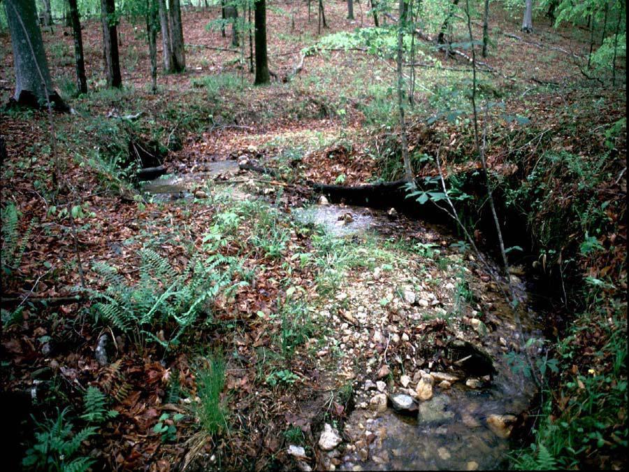
11 Table 2. Percent error in total stream length within the study watersheds as depicted on NCRS and USGS maps compared to onsite determinations. Region NRCS Maps USGS Maps Coastal Plain Piedmont Northern Mountains Central Mountains Southwestern Mountains NCDWQ Teams Mapped streams with GPS in randomly selected study watersheds of about 0.5 mi 2 in area
12 Stream definition Basic Problem One underlying past problem is lack of consistent stream definition Class taught by NCSU (Dr. Jim Gregory) and DWQ staff for past 10 years about 40 times Developed and refined stream identification method so useable across entire state Four day class with field and written exams Method now standard in North Carolina and widely used in southeastern U.S. Identification Methods for the Origins of Intermittent and Perennial streams NC Division of Water Quality Version 3.1 Effective Date: February 28, 2005 Available on website at h2o.enr.state.nc.us/ncwetlands
13 What is the solution? Goal - A GIS-based map of streams in the state based on field data with known levels of accuracy. NC OneMap will be the new state stream map NC Center for Geographic Information and Analysis (CGIA) as main contact DWQ as technical support, field data and modeling

14 Current NC One map Stream data availability currently only in NC mountains Catawba Lower Little Tennessee/Upper Little Tennessee/Tugaloo Nolichucky/Watauga Pigeon Seneca Tuckasegee Upper Broad Upper French Broad Upper New/Upper Yadkin
15 DWQ Headwater Stream Spatial Dataset Will augment NC ONE stream map Accessible through NC ONE stream map Keys to success Continue field data collection GIS support Stream ID spatial database (web-based) Continued coordination with CGIA
16 APPROACH AND OBJECTIVES Use LiDAR data from the NC Floodplain Mapping Program to create new topographic maps at a resolution of 5 meters (16.4 feet) Conduct field identification and mapping of 1st and 2nd order intermittent and perennial headwater stream origins in selected watersheds Build a geodatabase of study watersheds to include field data, DEMs and DEMderived data and other GIS data, e.g., slope, contributing drainage area, curvature, soils, precipitation and Ecoregion Conduct spatial analysis using GIS data and field data Use field data and other GIS data to create predictive, statistical models of streams and origins

17 Existing stream mapping data from Pilot Study
18 Contributing Drainage Areas for Stream Origins (Ephemeral to Intermittent/Perennial) Eastern Blue Ridge Foothills EPA Level IV Ecoregion Northern Carolina Triassic Outer Slatebelt Basins Piedmont Acres Quantiles Acres Acres Acres Min % % Median % % Max Rolling Coastal Plain Acres
19 Crucial question What is map accuracy? Three accuracy measures Presence/absence - percentage of streams occupying the same valley as the field-mapped streams Length - percentage of modeled stream length by stream order that is the same as the fieldmapped stream length by stream order Flow duration - percentage of intermittent and perennial stream cells that are coincident with the same intermittent and perennial stream cells as the field-mapped streams.

20 Headwater Stream Model Stream location accuracy = 84% Stream length accuracy 1 st order = 58% 2 nd order = 96% 3 rd order = 98% Overall = 83% Flow duration ~ 30%
21 Next Steps Refinement of statistical models for Slate Belt Ecoregion Focus on flow duration accuracy Work with CGIA and DOT on a pilot study in Slate Belt Ecoregion Select several permitted projects Develop accuracy assessment based on existing field data Select proposed project Work with regulators and DOT staff on selection of preferred alternative Prepare maps for project Document cost savings with reduced field time to examine alternative alignments
22 Next Steps (cont.) Once document utility of process, then expand statewide Supplement existing data by Ecoregion Mountains determine accuracy of existing enhanced maps Work with local governments and other sources to collect data Lincoln County work underway Permitted projects where DWQ has confirmed stream origins such as PCS Phosphate in Beaufort County Collect field data for remaining Ecoregions Prioritize data collection by DOT, CGIA and DWQ goals Develop predictive models with known levels of accuracy Incorporate results into NC OneMap with CGIA
23 Questions?
Mapping Headwater Streams. Intermittent and Perennial Headwater Stream Model Development and Spatial Application
 Mapping Headwater Streams: Intermittent and Perennial Headwater Stream Model Development and Spatial Application North Carolina Division of Water Quality Final Report for Federal Highway Administration
NC Streambed Mapping Project Issue Paper
 ISSUE 1: The Western North Carolina Drainage Area Requirement Issue Several inquiries and discussions in regard to the determination of the 6-acre drainage area requirement as the upstream limit have been
Issue 44: Phase II & III H&H Issues Date: 07/03/2006 Page 1
 Background Phase I of the NCFMP studies have primarily focused on the coastal plain and sandhills physiographic regions in of the State. Phase II and III study areas will focus on the piedmont, foothills,
ACCURACY ASSESSMENTS FOR HEADWATER STREAM MAPS IN WESTERN NORTH CAROLINA
 ACCURACY ASSESSMENTS FOR HEADWATER STREAM MAPS IN WESTERN NORTH CAROLINA Amanda Marie Johnson Department of Forestry and Environmental Resources North Carolina State University May 2013 Dr. Ted Shear Dr.
COMPARISON OF STREAM EXTRACTION MODELS USING LIDAR DEMS. Thomas P. Colson, James D. Gregory, Helena Mitasova, and Stacy A. C.
 GEOGRAPHIC INFORMATION SYSTEMS AND WATER RESOURCES IV AWRA SPRING SPECIALTY CONFERENCE Houston, Texas May 8-10, 2006 Copyright 2006, AWRA COMPARISON OF STREAM EXTRACTION MODELS USING LIDAR DEMS Thomas
Adam Hogg Inventory Monitoring & Assessment, Ministry of Natural Resources Headwaters Workshop May 20, 2009
 Geomatics Tools for Mapping Headwater Streams Adam Hogg Inventory Monitoring & Assessment, Ministry of Natural Resources Headwaters Workshop May 20, 2009 Outline The Challenge What is a headwater stream?
Remote Sensing and Geospatial Application for Wetlands Mapping, Assessment, and Mitigation
 Remote Sensing and Geospatial Application for Wetlands Mapping, Assessment, and Mitigation Hydrology Soils MSU Seminar Series Remote Sensing and Geospatial Applications September 4, 2002 Vegetation NEPA
MISSOURI LiDAR Stakeholders Meeting
 MISSOURI LiDAR Stakeholders Meeting East-West Gateway June 18, 2010 Tim Haithcoat Missouri GIO Enhanced Elevation Data What s different about it? Business requirements are changing.fast New data collection
Appendix C. Questionnaire Summary of Responses Geographic Information Systems
 Appendix C Questionnaire Summary of Responses Geographic Information Systems 1. Is your agency using or planning use of GIS for: a. general mapping (e.g. highway routes, political boundaries, etc.) b.
Improvement of the National Hydrography Dataset for Parts of the Lower Colorado Region and Additional Areas of Importance to the DLCC
 Improvement of the National Hydrography Dataset for Parts of the Lower Colorado Region and Additional Areas of Importance to the DLCC Carlos Reyes-Andrade California State University, Northridge September
Leveraging LiDAR for Statewide NHD Hydrography Projects. Susan Phelps, CFM, GISP
 Leveraging LiDAR for Statewide NHD Hydrography Projects Susan Phelps, CFM, GISP Mon, July 11 th, 2016 National Hydrography Dataset (NHD) Background Why Local-Res NHD? Drivers Include: Availability of accurate
Summary Description Municipality of Anchorage. Anchorage Coastal Resource Atlas Project
 Summary Description Municipality of Anchorage Anchorage Coastal Resource Atlas Project By: Thede Tobish, MOA Planner; and Charlie Barnwell, MOA GIS Manager Introduction Local governments often struggle
GIS feature extraction tools in diverse landscapes
 CE 394K.3 GIS in Water Resources GIS feature extraction tools in diverse landscapes Final Project Anna G. Kladzyk M.S. Candidate, Expected 2015 Department of Environmental and Water Resources Engineering
Assessing Michigan s Biological diversity. Michigan Natural Features Inventory MSU Extension
 Assessing Michigan s Biological diversity John Paskus,, Amy Derosier,, Edward Schools, and Helen Enander Michigan Natural Features Inventory MSU Extension Goal Provide scientifically based information
MVP WMS, George Schorr
 APPROVED JURISDICTIONAL DETERMINATION FORM U.S. Army Corps of Engineers This form should be completed by following the instructions provided in Section IV of the JD Form Instructional Guidebook. SECTION
Pierce Cedar Creek Institute GIS Development Final Report. Grand Valley State University
 Pierce Cedar Creek Institute GIS Development Final Report Grand Valley State University Major Goals of Project The two primary goals of the project were to provide Matt VanPortfliet, GVSU student, the
A Comparison of Manual and Computer-Assisted Drainage Delineation Methods for Hydrologic-Unit Map Development
 This paper was peer-reviewed for scientific content. Pages 1118-1127. In: D.E. Stott, R.H. Mohtar and G.C. Steinhardt (eds). 2001. Sustaining the Global Farm. Selected papers from the 10th International
Chapter 6. Fundamentals of GIS-Based Data Analysis for Decision Support. Table 6.1. Spatial Data Transformations by Geospatial Data Types
 Chapter 6 Fundamentals of GIS-Based Data Analysis for Decision Support FROM: Points Lines Polygons Fields Table 6.1. Spatial Data Transformations by Geospatial Data Types TO: Points Lines Polygons Fields
Project Leader: Project Partners:
 UTILIZING LIDAR TO MAP HIGH PRIORITY WOODLAND HABITAT IN ARKANSAS DEVELOPING METHODOLOGY AND CONDUCTING A PILOT PROJECT IN THE OZARK HIGHLANDS TO MAP CURRENT EXTENT, SIZE AND CONDITION Project Summary
ENGINEER S CERTIFICATION OF FAULT AREA DEMONSTRATION (40 CFR )
") PLATTE RIVER POWER AUTHORITY RAWHIDE ENERGY STATION BOTTOM ASH TRANSFER (BAT) IMPOUNDMENTS LARIMER COUNTY, CO ENGINEER S CERTIFICATION OF FAULT AREA DEMONSTRATION (40 CFR 257.62) FOR COAL COMBUSTION RESIDUALS
PLATTE RIVER POWER AUTHORITY RAWHIDE ENERGY STATION BOTTOM ASH TRANSFER (BAT) IMPOUNDMENTS LARIMER COUNTY, CO ENGINEER S CERTIFICATION OF FAULT AREA DEMONSTRATION (40 CFR 257.62) FOR COAL COMBUSTION RESIDUALS
Figure 0-18: Dendrogeomorphic analysis of streambank erosion and floodplain deposition (from Noe and others, 2015a)
") Appendix 9A: Stream to River During the development of the Phase 6 Watershed Model, multiple methods for determining coefficients were often attempted. In some cases, the methods are averaged or otherwise
Appendix 9A: Stream to River During the development of the Phase 6 Watershed Model, multiple methods for determining coefficients were often attempted. In some cases, the methods are averaged or otherwise
Waterborne Environmental, Inc., Leesburg, VA, USA 2. Syngenta Crop Protection, LLC, North America 3. Syngenta Crop Protection, Int.
 Application of High Resolution Elevation Data (LiDAR) to Assess Natural and Anthropogenic Agricultural Features Affecting the Transport of Pesticides at Multiple Spatial Scales Josh Amos 1, Chris Holmes
StreamStats: Delivering Streamflow Information to the Public. By Kernell Ries
 StreamStats: Delivering Streamflow Information to the Public By Kernell Ries U.S. Department of the Interior U.S. Geological Survey MD-DE-DC District 410-238-4317 kries@usgs.gov StreamStats Web Application
Chesapeake Bay Remote Sensing Pilot Executive Briefing
 Chesapeake Bay Remote Sensing Pilot Executive Briefing Introduction In his Executive Order 13506 in May 2009, President Obama stated The Chesapeake Bay is a national treasure constituting the largest estuary
Data Collection and GIS Applications
 Data Collection and GIS Applications Governor s s Conference on the Management of the Illinois River System Jeff Jack of all Trades Boeckler, IDNR Introduction Collecting available GIS data sets Creating
Potential Restorable Wetlands (PRWs):
:") ASWM Webinar Sept. 17, 2014 Potential Restorable Wetlands (PRWs): Working definition: wetland hydrology and soils minus presently mapped wetlands for the re-establishment of wetlands Hydric Soil Query
ASWM Webinar Sept. 17, 2014 Potential Restorable Wetlands (PRWs): Working definition: wetland hydrology and soils minus presently mapped wetlands for the re-establishment of wetlands Hydric Soil Query
APPROVED JURISDICTIONAL DETERMINATION FORM U.S. Army Corps of Engineers
 APPROVED JURISDICTIONAL DETERMINATION FORM U.S. Army Corps of Engineers This form should be completed by following the instructions provided in Section IV of the JD Form Instructional Guidebook. SECTION
ROAD SEDIMENT ASSESSMENT & MODELING: KOOTENAI-FISHER TMDL PLANNING AREA ROAD GIS LAYERS & SUMMARY STATISTICS
 ROAD SEDIMENT ASSESSMENT & MODELING: KOOTENAI-FISHER TMDL PLANNING AREA ROAD GIS LAYERS & SUMMARY STATISTICS Prepared by: ATKINS Water Resources Group 820 North Montana Avenue Helena, MT 59601 November
ESRI NONPROFIT/CONSERVATION GRANTS PROGRAM STATUS REPORT JANUARY 2010
 ESRI NONPROFIT/CONSERVATION GRANTS PROGRAM STATUS REPORT JANUARY 2010 Grantee ESRI Client Number 150983 FARMINGTON RIVER WATERSHED ASSOCIATION 749 Hopmeadow Street, Simsbury, Connecticut 06070 Contact:
Lecture 3. Data Sources for GIS in Water Resources
 Lecture 3 Data Sources for GIS in Water Resources GIS in Water Resources Spring 2015 http://www.data.gov/ 1 USGS GIS data for Water http://water.usgs.gov/maps.html Watersheds of the US 2-digit water resource
Floodplain modeling. Ovidius University of Constanta (P4) Romania & Technological Educational Institute of Serres, Greece
 Romania & Technological Educational Institute of Serres, Greece") Floodplain modeling Ovidius University of Constanta (P4) Romania & Technological Educational Institute of Serres, Greece Scientific Staff: Dr Carmen Maftei, Professor, Civil Engineering Dept. Dr Konstantinos
Floodplain modeling Ovidius University of Constanta (P4) Romania & Technological Educational Institute of Serres, Greece Scientific Staff: Dr Carmen Maftei, Professor, Civil Engineering Dept. Dr Konstantinos
Development of Webbased. Tool for Tennessee
 Development of Webbased Farm Mapping Tool for Tennessee Southern Region Water Quality Conference, Oct. 24 2005 Forbes Walker and Alan Jolly Biosystems Engineering and SOIL SCIENCE Nutrient Management Planning
Improvement of the National Hydrography Dataset for US Forest Service Region 3 in Cooperation with the National Forest Service
 Improvement of the National Hydrography Dataset for US Forest Service Region 3 in Cooperation with the National Forest Service Christian L. DeCasas California State University, Northridge November 7 th,
APPROVED JURISDICTIONAL DETERMINATION FORM U.S. Army Corps of Engineers
 APPROVED JURISDICTIONAL DETERMINATION FORM U.S. Army Corps of Engineers This form should be completed by following the instructions provided in Section IV of the JD Form Instructional Guidebook. SECTION
Chapter 3. Description of the Study Area. Karl Taboga, James Stafford and Paul Taucher 3-19
 Chapter 3 Description of the Study Area Karl Taboga, James Stafford and Paul Taucher 3-19 T his study examines groundwater resources that underlie the Bear River drainage basin in Wyoming as well as areas
Chapter 2 - Little Tennessee River Subbasin Includes Fontana Lake and the Tuckasegee River Watershed
 Chapter 2 - Little Tennessee River Subbasin 04-04-02 Includes Fontana Lake and the Tuckasegee River Watershed 2.1 Water Quality Overview Subbasin 04-04-02 at a Glance Land and Water Land area: 1,021 mi
Wetland and Riparian Mapping: An Overview of the Montana Program
 Wetland and Riparian Mapping: An Overview of the Montana Program Meghan Burns, Catherine McIntyre, Karen Newlon Ecology Program Montana Natural Heritage Program Helena, MT Montana Natural Heritage Program
Title: ArcMap: Calculating Soil Areas for Storm Water Pollution Prevention Plans Authors: Brandy Woodcock, Benjamin Byars
 Title: ArcMap: Calculating Soil Areas for Storm Water Pollution Prevention Plans Authors: Brandy Woodcock, Benjamin Byars Introduction Abstract: The use of ArcMap to calculate soil areas for storm water
SAN FRANCISCO DISTRICT INFORMATION REQUESTED FOR VERIFICATION OF CORPS JURISDICTION
 DEPARTMENT OF THE ARMY SAN FRANCISCO DISTRICT, U.S. ARMY CORPS OF ENGINEERS 1455 MARKET STREET SAN FRANCISCO, CALIFORNIA 94103-1398 SAN FRANCISCO DISTRICT INFORMATION REQUESTED FOR VERIFICATION OF CORPS
Web-based Tools for Soil Erosion Assessment/Management
 Web-based Tools for Soil Erosion Assessment/Management Glenn O Neil GIS Specialist Institute of Water Research Michigan State University Managing and Understanding Sediments in Your Watershed Workshop
APPROVED JURISDICTIONAL DETERMINATION FORM U.S. Army Corps of Engineers
 APPROVED JURISDICTIONAL DETERMINATION FORM U.S. Army Corps of Engineers This form should be completed by following the instructions provided in Section IV of the JD Form Instructional Guidebook. SECTION
4. GIS Implementation of the TxDOT Hydrology Extensions
 4. GIS Implementation of the TxDOT Hydrology Extensions A Geographic Information System (GIS) is a computer-assisted system for the capture, storage, retrieval, analysis and display of spatial data. It
Section 4: Model Development and Application
 Section 4: Model Development and Application The hydrologic model for the Wissahickon Act 167 study was built using GIS layers of land use, hydrologic soil groups, terrain and orthophotography. Within
2006 GIS-T T Symposium Columbus Ohio
 2006 GIS-T T Symposium Columbus Ohio Creating a Location Based Response System Using ESRI Technology Brian Stevens, CP Woolpert, Inc. Agenda Introduction What is LBRS? History Specifications Proposed Method
MEMORANDUM FOR SWG
 MEMORANDUM FOR SWG-2007-1623 Subject: Jurisdictional Determination (JD) for SWG-2007-1623 on Interdunal Wetlands Adjacent to Traditional Navigable Waters (TNWs) Summary The U.S. Environmental Protection
Wetlands and Riparian Mapping Framework Technical Meeting
 Wetlands and Riparian Mapping Framework Technical Meeting Meghan Burns Landscape Ecologist Linda Vance Senior Ecologist Why wetland and riparian mapping? Preliminary site assessment for the presence of
Minimum Standards for Wetland Delineations
 Minimum Standards for Wetland Delineations Jason Gipson Chief, Utah/Nevada Regulatory Branch Sacramento District Regulatory Program Workshop 16 Mar 2016 US Army Corps of Engineers Delineation Report Minimum
Overview of fluvial and geotechnical processes for TMDL assessment
 Overview of fluvial and geotechnical processes for TMDL assessment Christian F Lenhart, Assistant Prof, MSU Research Assoc., U of M Biosystems Engineering Fluvial processes in a glaciated landscape Martin
Quick Response Report #126 Hurricane Floyd Flood Mapping Integrating Landsat 7 TM Satellite Imagery and DEM Data
 Quick Response Report #126 Hurricane Floyd Flood Mapping Integrating Landsat 7 TM Satellite Imagery and DEM Data Jeffrey D. Colby Yong Wang Karen Mulcahy Department of Geography East Carolina University
Introducing Iowa StreamStats Version 4, a Redesign of the USGS Application for Estimating Streamflow Stats
 Introducing Iowa StreamStats Version 4, a Redesign of the USGS Application for Estimating Streamflow Stats Presented at the 2016 Iowa Water Conference Ames, IA March 24, 2016 by David Eash U.S. Geological
Basin-scale analysis of long-term sediment-generation rates derived from 10 Be in river sediment:
 Basin-scale analysis of long-term sediment-generation rates derived from 10 Be in river sediment: The Susquehanna River basin and beyond Joanna M. Reuter M.S. Proposal April 30, 2003 Paul Bierman, advisor
Objectives: After completing this assignment, you should be able to:
 Data Analysis Assignment #1 Evaluating the effects of watershed land use on storm runoff Assignment due: 21 February 2013, 5 pm Objectives: After completing this assignment, you should be able to: 1) Calculate
Louisiana Transportation Engineering Conference. Monday, February 12, 2007
 Louisiana Transportation Engineering Conference Monday, February 12, 2007 Agenda Project Background Goal of EIS Why Use GIS? What is GIS? How used on this Project Other site selection tools I-69 Corridor
Chapter 6 Mapping and Online Tools
 Chapter 6 Mapping and Online Tools The stream site you monitor is just part of a much larger system. When analyzing stream health, it is important to take a holistic view by considering the entire watershed.
Custom Soil Resource Report for Forrest County, Mississippi
 United States Department of Agriculture Natural Resources Conservation Service A product of the National Cooperative Soil Survey, a joint effort of the United States Department of Agriculture and other
Base Level Engineering FEMA Region 6
 Base Level Engineering Over the past five years, has been evaluating its investment approach and data preparation work flow to establish an efficient and effective change in operation, generating an approach
GeoWEPP Tutorial Appendix
 GeoWEPP Tutorial Appendix Chris S. Renschler University at Buffalo - The State University of New York Department of Geography, 116 Wilkeson Quad Buffalo, New York 14261, USA Prepared for use at the WEPP/GeoWEPP
Name NRS 509 Exam I. Right Map
 Read every question carefully. You may use a calculator if you wish. Conversion tables are provided at the end of the exam. If you have any questions, raise your hand. Be sure to show your work on computational
Climate. Annual Temperature (Last 30 Years) January Temperature. July Temperature. Average Precipitation (Last 30 Years)
 January Temperature. July Temperature. Average Precipitation (Last 30 Years)") Climate Annual Temperature (Last 30 Years) Average Annual High Temp. (F)70, (C)21 Average Annual Low Temp. (F)43, (C)6 January Temperature Average January High Temp. (F)48, (C)9 Average January Low Temp.
Climate Annual Temperature (Last 30 Years) Average Annual High Temp. (F)70, (C)21 Average Annual Low Temp. (F)43, (C)6 January Temperature Average January High Temp. (F)48, (C)9 Average January Low Temp.
GISHydro2000: A Tool for Automated Hydrologic Analysis in Maryland. G. E. Moglen 1
 GISHydro2000: A Tool for Automated Hydrologic Analysis in Maryland G. E. Moglen 1 1 Department of Civil and Environmental Engineering, University of Maryland, College Park, MD 20742; PH (301) 405-1964;
The 3D Elevation Program: Overview. Jason Stoker USGS National Geospatial Program ESRI 2015 UC
 + The 3D Elevation Program: Overview Jason Stoker USGS National Geospatial Program ESRI 2015 UC + 2 A little history USGS has a long, proud tradition of mapmaking (2009) + 3 The changing times Mapping
Kaskaskia Morphology Study Headwaters to Lake Shelbyville
 Kaskaskia Morphology Study Headwaters to Lake Shelbyville KWA Mini Summit 5 March 2012 1 Kaskaskia Morphology Study Headwaters to Lake Shelbyville Conducted by U.S. Army Corps of Engineers, St. Louis District
2 Georgia: Its Heritage and Its Promise
 TERMS region, erosion, fault, elevation, Fall Line, aquifer, marsh, climate, weather, precipitation, drought, tornado, hurricane, wetland, estuary, barrier island, swamp PLACES Appalachian Mountains, Appalachian
Watershed concepts for community environmental planning
 Purpose and Objectives Watershed concepts for community environmental planning Dale Bruns, Wilkes University USDA Rural GIS Consortium May 2007 Provide background on basic concepts in watershed, stream,
Natural and Human Influences on Flood Zones in Wake County. Georgia Ditmore
 Natural and Human Influences on Flood Zones in Wake County Georgia Ditmore Prepared for GEOG 591 December 5, 2014 2 Table of Contents Introduction.3 Objectives...5 Methods...6 Conclusion.11 References
Appendix J Vegetation Change Analysis Methodology
 Appendix J Vegetation Change Analysis Methodology Regional Groundwater Storage and Recovery Project Draft EIR Appendix-J April 2013 APPENDIX J- LAKE MERCED VEGETATION CHANGE ANALYSIS METHODOLOGY Building
Name NRS 409 Exam I. 1. (24 Points) Consider the following questions concerning standard data for GIS systems.
 Consider the following questions concerning standard data for GIS systems.") Read every question carefully. You may use a calculator if you wish. Conversion tables are provided at the end of the exam. If you have any questions, raise your hand. Be sure to show your work on computational
Read every question carefully. You may use a calculator if you wish. Conversion tables are provided at the end of the exam. If you have any questions, raise your hand. Be sure to show your work on computational
NATIONAL HYDROGRAPHY DATASET (NHD) UPDATE PROJECT FOR US FOREST SERVICE REGION 3
 UPDATE PROJECT FOR US FOREST SERVICE REGION 3") NATIONAL HYDROGRAPHY DATASET (NHD) UPDATE PROJECT FOR US FOREST SERVICE REGION 3 Allison Moncada California State University, Northridge February 2018 July 2018 Advisor: Joel Osuna Center for Geospatial
NATIONAL HYDROGRAPHY DATASET (NHD) UPDATE PROJECT FOR US FOREST SERVICE REGION 3 Allison Moncada California State University, Northridge February 2018 July 2018 Advisor: Joel Osuna Center for Geospatial
Huron Creek Watershed 2005 Land Use Map
 Huron Creek Watershed 2005 Land Use Map Created By: Linda Kersten, 12/20/06 Created For: MTU Introduction to GIS Class (FW 5550) The Huron Creek Watershed Advisory Committee Michigan Technological University,
Vermont Stream Geomorphic Assessment. Appendix E. River Corridor Delineation Process. VT Agency of Natural Resources. April, E0 - April, 2004
 Vermont Stream Geomorphic Assessment Appendix E River Corridor Delineation Process Vermont Agency of Natural Resources - E0 - River Corridor Delineation Process Purpose A stream and river corridor delineation
McHenry County Property Search Sources of Information
 Disclaimer: The information in this system may contain inaccuracies or typographical errors. The information in this system is a digital representation of information derived from original documents; as
WHAT MAKES A GOOD GIS LAB EXERCISE? Robert N. Martin
 WHAT MAKES A GOOD GIS LAB EXERCISE? Robert N. Martin ABSTRACT Having taught GIS for over fifteen years in a lecture/laboratory format, I have developed a series of laboratory exercise that provide a good
Urbanization affects the extent and hydrologic permanence of headwater streams in a midwestern US metropolitan area
 J. N. Am. Benthol. Soc., 2009, 28(4):911 928 2009 by The North American Benthological Society DOI: 10.1899/08-178.1 Published online: 27 October 2009 Urbanization affects the extent and hydrologic permanence
J.H. Campbell Generating Facility Pond A - Location Restriction Certification Report
 J.H. Campbell Generating Facility Pond A - Location Restriction Certification Report Pursuant to: 40 CFR 257.60 40 CFR 257.61 40 CFR 257.62 40 CFR 257.63 40 CFR 257.64 Submitted to: Consumers Energy Company
Follow this and additional works at: Part of the Earth Sciences Commons, and the Environmental Sciences Commons
 University of South Carolina Scholar Commons Theses and Dissertations 2017 A Study of Two Digital Hydrological Networks in South Carolina and an Assessment of Site Reconnaissance Results from the SC Department
Climatic Change Implications for Hydrologic Systems in the Sierra Nevada
 Climatic Change Implications for Hydrologic Systems in the Sierra Nevada Part Two: The HSPF Model: Basis For Watershed Yield Calculator Part two presents an an overview of why the hydrologic yield calculator
DRAFT WATERSHED STRATIFICATION METHODOLOGY FOR TMDL SEDIMENT AND HABITAT INVESTIGATIONS
 DRAFT WATERSHED STRATIFICATION METHODOLOGY FOR TMDL SEDIMENT AND HABITAT INVESTIGATIONS Montana Department of Environmental Quality 1520 East Sixth Avenue Helena, MT 59620 April 2008 1.0 INTRODUCTION 1.1
Wetland Mapping & Functional Assessment Canadian River Watershed New Mexico. Association of State Wetland Managers
 Wetland Mapping & Functional Assessment Canadian River Watershed New Mexico Association of State Wetland Managers November, 2012 Approach for this project based on: EPA 2006 Document: Application of Elements
Appendix D. Sediment Texture and Other Soil Data
 5 6 7 8 Appendix D. Sediment Texture and Other Soil Data This appendix describes the sediment texture of the aquifer system in the Restoration Area. The contents of this appendix describe the: Importance
SITE SUMMARY REPORT Candor Dump NONCD Montgomery County
 SITE SUMMARY REPORT Candor Dump NONCD 0000433 Montgomery County Senate Bill 1492 State of North Carolina State Contract N06009S Schnabel Project No. 06210002.23 February 23, 2010 Prepared for: North Carolina
The subject paper is being submitted for approval for publication in the annual volume entitled Geological Survey Research.
 Water Resources Division 345 Middlefield Road Menlo Park, California January 12, 1965 Memorandum To: Mr. Frank E. Clark, Chief, General Hydrology Branch Thru: Area Hydrologist PCA From: Valmore C. LaMarche
MAPPING POTENTIAL LAND DEGRADATION IN BHUTAN
 MAPPING POTENTIAL LAND DEGRADATION IN BHUTAN Moe Myint, Geoinformatics Consultant Rue du Midi-8, CH-1196, Gland, Switzerland moemyint@bluewin.ch Pema Thinley, GIS Analyst Renewable Natural Resources Research
Presented by: Bryan Bloch GIS Specialist DNREC Division of Watershed Stewardship
 Presented by: Bryan Bloch GIS Specialist DNREC Division of Watershed Stewardship Bryan Hall, AICP Sussex County Circuit Rider Planner, Office of State Planning Coordination, OMB November 19, 2012 UD Sustainable
Welcome to NetMap Portal Tutorial
 Welcome to NetMap Portal Tutorial Potential Applications What Can you do with the Portal? At least 25 things! 1) Locate the best potential fish habitats. 2) Identify biological hotspots. 3) Map floodplain
MEMORANDUM. REVISED Options for Landslide Regulations: Setbacks and Slope Height
 Snohomish County Council Office MS #609 3000 Rockefeller Avenue Everett, WA 98201 (425) 388-3494 MEMORANDUM DATE: May 2, 2014 TO: FROM: RE: Councilmembers Will Hall, Council Staff REVISED Options for Landslide
Watershed Modeling Orange County Hydrology Using GIS Data
 v. 10.0 WMS 10.0 Tutorial Watershed Modeling Orange County Hydrology Using GIS Data Learn how to delineate sub-basins and compute soil losses for Orange County (California) hydrologic modeling Objectives
LIDAR: Statutory Compliance Benefits for Nebraska Natural Resources
 LIDAR: Statutory Compliance Benefits for Nebraska Natural Resources 2011 Nebraska GIS Symposium La Vista, NE April 21, 2011 Doug Hallum, P.G. Integrated Water Management Coordinator Nebraska Department
Drainage Records Modernization Guidelines
 Drainage Records Modernization Guidelines Prepared by: Board of Water and Soil Resources In partnership with: Water Resources Center Minnesota State University, Mankato Drainage Records Modernization Guidelines
GRAPEVINE LAKE MODELING & WATERSHED CHARACTERISTICS
 GRAPEVINE LAKE MODELING & WATERSHED CHARACTERISTICS Photo Credit: Lake Grapevine Boat Ramps Nash Mock GIS in Water Resources Fall 2016 Table of Contents Figures and Tables... 2 Introduction... 3 Objectives...
Estimating Stream Gradient Using NHD Stream Lines and DEM Data
 Estimating Stream Gradient Using NHD Stream Lines and DEM Data David Nagel, John M. Buffington, and Daniel Isaak U.S. Forest Service, Rocky Mountain Research Station Boise Aquatic Sciences Lab Boise, ID
Using EMDS for CLs Mapping and Assessment: SE Demo Project. Keith Reynolds, USDA Forest Service Tim Sullivan, E&S Environmental Tim Lewis, U.S.
 Using EMDS for CLs Mapping and Assessment: SE Demo Project Partners: Keith Reynolds, USDA Forest Service Tim Sullivan, E&S Environmental Tim Lewis, U.S. EPA What is EMDS? The Ecosystem Management Decision
Natural Variability in Annual Maximum Water Level and Outflow of Yellowstone Lake
 Natural Variability in Annual Maximum Water Level and Outflow of Yellowstone Lake Phillip E. Farnes Abstract The water level in Yellowstone Lake varies each year in response to differences in the winter
3.11 Floodplains Existing Conditions
 Other stormwater control practices may be needed to mitigate water quality impacts. In addition to detention facilities, other practices such as vegetated basins/buffers, infiltration basins, and bioswales
The Evolution of NWI Mapping and How It Has Changed Since Inception
 The Evolution of NWI Mapping and How It Has Changed Since Inception Some Basic NWI Facts: Established in 1974 Goal to create database on characteristics and extent of U.S. wetlands Maps & Statistics In
Statewide Topographic Mapping Program
 Statewide Topographic Mapping Program February 28, 2018 www.dotd.la.gov Outline Purpose of the Statewide Topographic Mapping Program History Breakdown of R.S. 48:36 - Topographic Mapping Statewide Topographic
APPROVED JURISDICTIONAL DETERMINATION FORM U.S. Army Corps of Engineers
 APPROVED JURISDICTIONAL DETERMINATION FORM U.S. Army Corps of Engineers This form should be completed by following the instructions provided in Section IV of the JD Form Instructional Guidebook. SECTION
Introduction to Geographic Information Systems (GIS): Environmental Science Focus
: Environmental Science Focus") Introduction to Geographic Information Systems (GIS): Environmental Science Focus September 9, 2013 We will begin at 9:10 AM. Login info: Username:!cnrguest Password: gocal_bears Instructor: Domain: CAMPUS
Introduction to Geographic Information Systems (GIS): Environmental Science Focus September 9, 2013 We will begin at 9:10 AM. Login info: Username:!cnrguest Password: gocal_bears Instructor: Domain: CAMPUS
APPROVED JURISDICTIONAL DETERMINATION FORM U.S. Army Corps of Engineers
 APPROVED JURISDICTIONAL DETERMINATION FORM U.S. Army Corps of Engineers This form should be completed by following the instructions provided in Section IV of the JD Form Instructional Guidebook. SECTION
Using Soils Data to Map
 Using Soils Data to Map The Challenges of Eco Engineering: Making the Connections Natural Between Floodplains Engineering and Ecology Kevin Coulton, P.E., CFM cbec eco engineering Chris Bowles, Ph.D.,
Web (Java, ArcGIS Server [WebADF, flex, silverlight]) Mobile (ArcGIS Mobile, ArcPad, Windows Mobile) Deskt
![Web (Java, ArcGIS Server [WebADF, flex, silverlight]) Mobile (ArcGIS Mobile, ArcPad, Windows Mobile) Deskt](/thumbs/96/129284052.jpg "Web (Java, ArcGIS Server [WebADF, flex, silverlight]) Mobile (ArcGIS Mobile, ArcPad, Windows Mobile) Deskt") GIS Services company in Lincoln, NE Custom GIS database design and build (for local, county, state and private corporations) Custom (ESRI and non-esri) application design and build in Java, C++, C#,.Net
GIS Services company in Lincoln, NE Custom GIS database design and build (for local, county, state and private corporations) Custom (ESRI and non-esri) application design and build in Java, C++, C#,.Net