Wetland Mapping & Functional Assessment Canadian River Watershed New Mexico. Association of State Wetland Managers
|
|
|
- Jodie Cobb
- 6 years ago
- Views:
Transcription


1 Wetland Mapping & Functional Assessment Canadian River Watershed New Mexico Association of State Wetland Managers November, 2012
2 Approach for this project based on: EPA 2006 Document: Application of Elements of a State Water Monitoring and Assessment Program For Wetlands
3 Elements of a State Water Monitoring and Assessment Program For Wetlands Goals of this document: provide guidelines for the implementation of a state wetland monitoring and assessment program align monitoring programs with the requirements of the Clean Water Act generate information necessary to report on condition of state wetland resources prioritize wetland protection, restoration and mitigation promote interstate consistency for wetland reporting

4 Core Indicators And Metrics Conceptual model of state wetland assessment showing: ecological attributes of wetlands response to human disturbance
5 EPA 3 Level Technical Approach Level 1 - Landscape Assessment: Use GIS and remote sensing to gain a landscape view of watershed and wetland condition. Typical assessment indicators include wetland coverage (NWI), land use and land cover Level 2 Rapid Wetland Assessment: Evaluate the general condition of individual wetlands using relatively simple field indicators. Assessment is often based on the characterization of stressors know to limit wetland functions e.g., road crossings, tile drainage, ditching. Level 3 Intensive Site Assessment Produce quantitative data with known certainty of wetland condition within an assessment area, used to refine rapid wetland assessment methods and diagnose the causes of wetland degradation. Assessment is typically accomplished using indices of biological integrity or hydrogeomorphic function. Products/Applications Targeting restoration and monitoring Landscape condition assessment Status and trends Integrated reporting CWA 305(b)/303(d) 401/404 permit decisions Integrated reporting Watershed planning Implementation monitoring of restoration projects, including nonpoint source BMPs, and Farm Bill programs WQS development, including use designation Integrated reporting Compensatory mitigation performance standards Verify levels 1 and 2 methods
6 Level 1 - Landscape Level Wetland Mapping & Assessment Project Objectives: Use remote sensing, image interpretation techniques, collateral GIS data, and best professional judgment to: Map or update the wetland landscape profile of a project study area (soil, hydrology, vegetation) Extend traditional wetland mapping to include interpretable hydrogeomorphic and other metrics Correlate wetland types and characteristics to wetland function on the landscape map and document additional wetland characteristics to provide continuity between Level 1, 2 and 3.
7
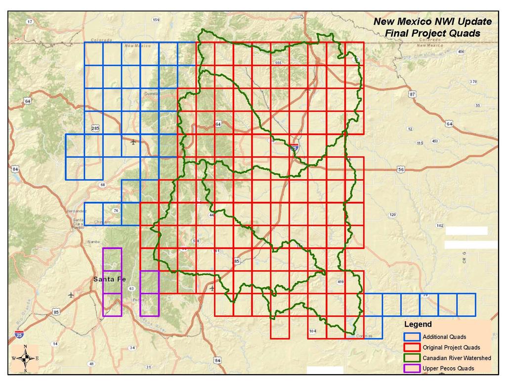
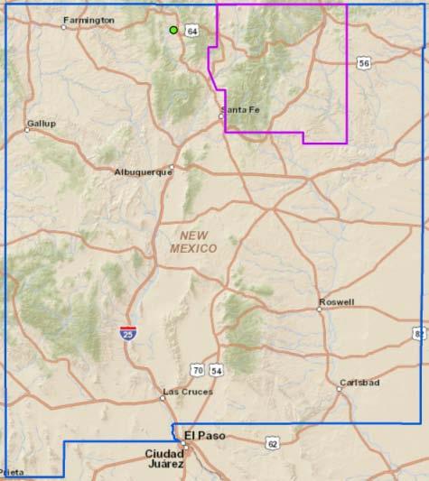
8 Northeastern New Mexico Study Area Description Watersheds (HUC 8): Upper Canadian, Upper Rio Grande, Upper Pecos Rivers Total Area: 9100 sq. miles or 5.7 M acres Counties: Colfax, Mora, San Miguel, Taos, Rio Arriba and Santa Fe Previous Wetland Mapping: None, limited site specific NWI Major Ecoregions: Montane forests, foothill shrub lands, tableland shrub and grasslands, high plains
9 Major Steps of Project Map and classify present-day wetlands: - NWI Cowardin classification - FGDC National Wetland Mapping Std - Map and classify adjacent riparian areas - project imagery 2009 NAIP - numerous collateral data layers Add hydrogeomorphic characteristics to wetlands: - LLWW interpretation and classification Develop functional correlation table: - utilize local wetland professionals bpj - establish wetland functions to be assessed - correlate wetland descriptors to functions Link to Rapid Assessment Methods - collect additional data, tie to HGM
10 Mapping and Classification Systems National Wetland Inventory (NWI) Cowardin (1976) System for Mapping Western Riparian Areas Dick/USFWS (2009) Landscape Position, Landform, Waterbody Type, Water Flow Path (LLWW) Tiner (2011) Potentially Restorable Wetlands Mapping SMUMN (2012)
11 National Wetland Inventory Based on Cowardin (1976) and endorsed by 2009 FGDC Federal Wetland Mapping Standard Dominant Life Forms (e.g. forested, emergent) Subclasses (e.g. Persistent, Non-persistent) Water Regimes (generally, e.g. Wet Soil Palustrine) Special Modifiers (certain, e.g. farmed, beaver, excavated etc.) 11
12 NM Project Imagery and Collateral Data Interpretation Challenges Limited resources for image acquisition Chose to move forward with existing NAIP imagery True color, mid summer, leaf on, drought conditions. Not an ideal image source for wetland interpretation Ideally would have been spring, leaf off, normal precipitation color infra-red Forced reliance on collateral data 12

13 Maxwell Wildlife Refuge 2009 NAIP

14 Maxwell Wildlife Refuge 2005 NAIP


15 Maxwell Wildlife Refuge Imagery

16 Maxwell Wildlife Refuge 2009 NAIP CIR
17 NM Collateral Data Sources USGS 1:24,000 DRG USGS NHD streams and waterbodies NRCS SURRGO Soils Data NAIP Imagery 2001, 2005, 2009 CIR Google Earth imagery time slider tool SWQB Stream Data (cold water, warm water, fish species) USGS 30m and 10m National Elevation Dataset USFS Springs and Seeps database

18 NM Pre and Post Mapping Field Validation Validation of image signatures Confirmation of landscape position and other hydrogeomorphic metrics

19 Final NWI Delineation
20 Riparian Mapping System System is a single unit category - riparian vegetation (Rp). Subsystem defines two categories reflecting the water source for the riparian area - lotic (1) and lentic (2). Class describes the dominant life form of riparian vegetation. Classes are: forested (FO), scrub/shrub (SS), and emergent (EM) Subclass further describes the Class as either dead (5), deciduous (6), evergreen (7), or mixed deciduous/evergreen (8). Dominance Type refers to vegetative species within the mapping unit, e.g. cottonwood (CW). Rp1FO6CW is interpreted as: System: Subsystem: Class: Subclass: Dominance: Rp - Riparian 1 - Lotic FO - Forested 6 - Deciduous CW - Cottonwood
21 LLWW Based on Tiner (2011)* Landscape Position - relationship between a wetland and an adjacent waterbody or not Landform - shape or physical form (island, basin, floodplain, etc.) Water Flow Path - directional flow of water (outflow, inflow, isolated, etc.) Water Body Type lake, pond, river, stream *derived from HGM hydrogeomorphic classification (Brinson 1993)
22 Landscape Position (LLWW continued) Lotic in or along rivers and streams and in floodplains Lentic in or along lakes Terrene completely surrounded by upland or nearly so; not flooded by river or streams 22
")
23 Lentic (LLWW continued) 23
")
24 Lotic (LLWW continued) 24
 25")
25 Terrene (LLWW continued) 25
26 Landforms (LLWW continued) Slope Island Fringe Floodplain (basin, flat) Interfluve (basin, flat) Basin Flat 26

27 Basin (BA)Landform 27

28 Flats (FL) Landform 28

29 Slope (SL) Landform 29
30 Floodplain (FL) Landform 30
31 Water Flow Paths Bidirectional (BI) Inflow (IN) Isolated (IS) Throughflow (TH) Outflow (OU) 31
 Waterflow")
32 Bidirectional (BI) Waterflow Path 32

33 Inflow (IN) Waterflow Path 33

34 Isolated (IS) Waterflow Path 34

35 Outflow (OU) Waterflow Path 35

36 Throughflow (TH) Waterflow Path 36
37 Waterbody Types River (RV) low, middle, high gradient dammed Stream (ST) low, middle, high gradient artificial Lake (RV) natural dammed Pond (PD) natural, dammed, excavated, beaver, other artificial 37
38 LLWW Interpretation and Coding During NWI mapping also consider and add LLWW codes: Example (next slides, highlighted polygon): NWI: PSS5C Paulustrine, scrub shrub - dead, seasonally flooded) LLWW: LS1BATHhw Lotic Stream low gradient, Basin, Through-flow, headwaters

39

40
41 Functional Correlation Exercise Project steering committee (NMED, NM HP, Corps, FWS, stakeholders) identified wetland functions for assessment : Surface Water Detention Streamflow Maintenance Shoreline Stabilization Nutrient Transformation Carbon Sequestration Sediment Retention Groundwater Recharge Wildlife Habitat Fish Habitat Water bird and Waterfowl Habitat 41
42 Functional Correlation What function does each wetland perform and how well? Each wetland polygon ranked high or moderate based on NWI type and LLWW characteristics Correlation tables from a variety of other projects used as a starting point Tiner (2003), Fizzell (2011), Miller et al. (2012), Richtman (2012) Steering committee assessed and modified these tables using Best Professional Judgment and local knowledge 42
43 Functional Correlation Wetland polygons are assigned to functional categories using a series of SQL queries Spatial queries are used to make assignments based on adjacency and proximity Collateral data layers (e.g. cold water streams, bedrock geology) also support function assignments Separate geodatabases are produced for each function Functional assignments and map products are reviewed with Steering Committee and in the field
44 Streamflow Maintenance Highly Functional All headwater wetlands Vegetated wetlands along streams, rivers, lakes Terrene pond wetlands with through or outflow All wetlands with organic soil adjacent to 3 rd order or higher streams Moderately Functional Terrene basin isolated or outflow vegetated wetlands All wetlands with mineral soil adjacent to 3 rd order or higher streams Other wetlands adjacent to lakes not already included in High 44

45
46

47
48 Extending Level 1 Mapping and Characterizations Map or model potentially restorable wetlands use terrain models (basins, flow network, TWI etc.) use hydric soil components from SSURGO subtract existing wetlands and non-compatible land uses orthorectify and classify historic aerial imagery Identify/describe reference wetlands of various types Record adjacent upland land uses and buffers coded to wetland geodatabase database by type and presence infiltration, runoff, erosion, sedimentation, nutrients, pollutants Add vegetation species, soils etc. where interpretable Crosswalk LLWW to regional HGM sub-classes for RAM

49
50 Questions? Andy Robertson Project Manager GeoSpatial Services Saint Mary s University of Minnesota aroberts@smumn.edu
Wetland and Riparian Mapping: An Overview of the Montana Program
 Wetland and Riparian Mapping: An Overview of the Montana Program Meghan Burns, Catherine McIntyre, Karen Newlon Ecology Program Montana Natural Heritage Program Helena, MT Montana Natural Heritage Program
Use of Remote Sensing and GIS for Wetland, Riparian, and Watershed Assessment, Restoration, and Monitoring
 Use of Remote Sensing and GIS for Wetland, Riparian, and Watershed Assessment, Restoration, and Monitoring Ralph Tiner Wetland Ecologist U.S. Fish & Wildlife Service National Wetlands Inventory Program
Wetlands and Riparian Mapping Framework Technical Meeting
 Wetlands and Riparian Mapping Framework Technical Meeting Meghan Burns Landscape Ecologist Linda Vance Senior Ecologist Why wetland and riparian mapping? Preliminary site assessment for the presence of
The Evolution of NWI Mapping and How It Has Changed Since Inception
 The Evolution of NWI Mapping and How It Has Changed Since Inception Some Basic NWI Facts: Established in 1974 Goal to create database on characteristics and extent of U.S. wetlands Maps & Statistics In
Appendix E: Cowardin Classification Coding System
 Appendix E: Cowardin Classification Coding System The following summarizes the Cowardin classification coding system and the letters and numbers used to define the USFWS NWI wetland types and subtypes:
Improvement of the National Hydrography Dataset for Parts of the Lower Colorado Region and Additional Areas of Importance to the DLCC
 Improvement of the National Hydrography Dataset for Parts of the Lower Colorado Region and Additional Areas of Importance to the DLCC Carlos Reyes-Andrade California State University, Northridge September
Summary Description Municipality of Anchorage. Anchorage Coastal Resource Atlas Project
 Summary Description Municipality of Anchorage Anchorage Coastal Resource Atlas Project By: Thede Tobish, MOA Planner; and Charlie Barnwell, MOA GIS Manager Introduction Local governments often struggle
Introduction to the Hydrogeomorphic (HGM) Classification System
 Classification System") Introduction to the Hydrogeomorphic (HGM) Classification System Objectives The Student Will be Able to: Define the 7 HGM Classes List the 3 Parameters That Define HGM Classes List the Major Water Budget
Introduction to the Hydrogeomorphic (HGM) Classification System Objectives The Student Will be Able to: Define the 7 HGM Classes List the 3 Parameters That Define HGM Classes List the Major Water Budget
Atlas of the Upper Gila River Watershed
 Atlas of the Upper Gila River Watershed Katie Banister, David Chan, Jessica M. Driscoll, Christopher Fullerton, Aaron Lien and Kelly Mott Lacroix January 2014 The University of Arizona Water Resources
National Wetlands Inventory Update for New England 2009
 National Wetlands Inventory Update for New England 2009 Ralph Tiner Wetland Ecologist U.S. Fish & Wildlife Service National Wetlands Inventory Program Where we ve been Maps Status and trends investigations
The Refugia Concept: Using Watershed Analysis to Prioritize Salmonid Habitat for Conservation and Restoration
 The Refugia Concept: Using Watershed Analysis to Prioritize Salmonid Habitat for Conservation and Restoration Christopher May Battelle & UW Cumulative Impacts of Urbanization Landscape Alterations Loss
GIS Data and Technology to Support Transportation & MPO Decision-Making & Planning. using an Eco-Logical* Approach within the Kansas City Region
 GIS Data and Technology to Support Transportation & MPO Decision-Making & Planning using an Eco-Logical* Approach within the Kansas City Region Authors (in alphabetical order): Tom Gerend, Tom Jacobs,
3.11 Floodplains Existing Conditions
 Other stormwater control practices may be needed to mitigate water quality impacts. In addition to detention facilities, other practices such as vegetated basins/buffers, infiltration basins, and bioswales
Distinct landscape features with important biologic, hydrologic, geomorphic, and biogeochemical functions.
 1 Distinct landscape features with important biologic, hydrologic, geomorphic, and biogeochemical functions. Have distinguishing characteristics that include low slopes, well drained soils, intermittent
APPROVED JURISDICTIONAL DETERMINATION FORM U.S. Army Corps of Engineers
 APPROVED JURISDICTIONAL DETERMINATION FORM U.S. Army Corps of Engineers This form should be completed by following the instructions provided in Section IV of the JD Form Instructional Guidebook. SECTION
An Integrated Habitat Classification and Map of the Lake Erie Basin: Final Report
 An Integrated Habitat Classification and Map of the Lake Erie Basin: Final Report Dr. Lucinda Johnson Natural Resources Research Institute University of Minnesota 5013 Miller Trunk Highway, Duluth, MN
Southern California Coastal Water Research Project. Sharon De Leon. California State University Northridge. June 19, May 2013
 Southern California Coastal Water Research Project Sharon De Leon California State University Northridge June 19, 2012- May 2013 Shawna Dark, Center of Geographical Studies, California State University
NATIONAL HYDROGRAPHY DATASET (NHD) UPDATE PROJECT FOR US FOREST SERVICE REGION 3
 UPDATE PROJECT FOR US FOREST SERVICE REGION 3") NATIONAL HYDROGRAPHY DATASET (NHD) UPDATE PROJECT FOR US FOREST SERVICE REGION 3 Allison Moncada California State University, Northridge February 2018 July 2018 Advisor: Joel Osuna Center for Geospatial
NATIONAL HYDROGRAPHY DATASET (NHD) UPDATE PROJECT FOR US FOREST SERVICE REGION 3 Allison Moncada California State University, Northridge February 2018 July 2018 Advisor: Joel Osuna Center for Geospatial
A Help Guide for Using gssurgo to Find Potential Wetland Soil Landscapes
 A Help Guide for Using gssurgo to Find Potential Wetland Soil Landscapes Wetland Mapping Consortium Webinar September 17, 2014 Dr. John M. Galbraith Crop & Soil Environmental Sciences Virginia Tech Wetland
Appendix I Feasibility Study for Vernal Pool and Swale Complex Mapping
 Feasibility Study for Vernal Pool and Swale Complex Mapping This page intentionally left blank. 0 0 0 FEASIBILITY STUDY BY GIC AND SAIC FOR MAPPING VERNAL SWALE COMPLEX AND VERNAL POOLS AND THE RESOLUTION
National Wetland Inventory
 Photo Interpretation Guide For Updating The National Wetland Inventory In Minnesota August 2011 National Wetland Inventory Introduction 1.1 Purpose of Photo Interpretation Guide 1 1.2 Contact information
ROAD SEDIMENT ASSESSMENT & MODELING: KOOTENAI-FISHER TMDL PLANNING AREA ROAD GIS LAYERS & SUMMARY STATISTICS
 ROAD SEDIMENT ASSESSMENT & MODELING: KOOTENAI-FISHER TMDL PLANNING AREA ROAD GIS LAYERS & SUMMARY STATISTICS Prepared by: ATKINS Water Resources Group 820 North Montana Avenue Helena, MT 59601 November
APPROVED JURISDICTIONAL DETERMINATION FORM U.S. Army Corps of Engineers
 APPROVED JURISDICTIONAL DETERMINATION FORM U.S. Army Corps of Engineers This form should be completed by following the instructions provided in Section IV of the JD Form Instructional Guidebook. SECTION
Watershed concepts for community environmental planning
 Purpose and Objectives Watershed concepts for community environmental planning Dale Bruns, Wilkes University USDA Rural GIS Consortium May 2007 Provide background on basic concepts in watershed, stream,
Opportunities to Improve Ecological Functions of Floodplains and Reduce Flood Risk along Major Rivers in the Puget Sound Basin
 Opportunities to Improve Ecological Functions of Floodplains and Reduce Flood Risk along Major Rivers in the Puget Sound Basin Christopher Konrad, US Geological Survey Tim Beechie, NOAA Fisheries Managing
Developing a Landscape-Level Reference Standard Wetland Profile for the Prairie Pothole Region, Montana
 Developing a Landscape-Level Reference Standard Wetland Profile for the Prairie Pothole Region, Montana Prepared for: The U.S. Environmental Protection Agency Prepared by: Melissa Hart and Linda Vance
REMOTE SENSING AND GEOSPATIAL APPLICATION FOR WETLAND MAPPING, ASSESSMENT, AND MITIGATION INTRODUCTION
 REMOTE SENSING AND GEOSPATIAL APPLICATION FOR WETLAND MAPPING, ASSESSMENT, AND MITIGATION Charles G. O Hara, Consortium Manager National Consortium on Remote Sensing in Transportation - Environmental Assessment
Ecological Site Descriptions ESDs : NRCS Site-based Approach to Land Classification and Evaluation. Nels Barrett, NRCS Ecologist SSSSNE 20
 Ecological Site Descriptions ESDs : NRCS Site-based Approach to Land Classification and Evaluation Nels Barrett, NRCS Ecologist SSSSNE 20 Overview Definition of Ecological Sites, ES Content of Ecological
GOAL 7 AREAS SUBJECT TO NATURAL DISASTERS AND HAZARDS. To protect life and property from natural disasters and hazards.
 GOAL 7 AREAS SUBJECT TO NATURAL DISASTERS AND HAZARDS A. GOALS: To protect life and property from natural disasters and hazards. B. POLICIES: 1. Floodplains shall be maintained as natural drainage-ways.
APPROVED JURISDICTIONAL DETERMINATION FORM U.S. Army Corps of Engineers
 APPROVED JURISDICTIONAL DETERMINATION FORM U.S. Army Corps of Engineers This form should be completed by following the instructions provided in Section IV of the JD Form Instructional Guidebook. SECTION
APPROVED JURISDICTIONAL DETERMINATION FORM U.S. Army Corps of Engineers
 APPROVED JURISDICTIONAL DETERMINATION FORM U.S. Army Corps of Engineers This form should be completed by following the instructions provided in Section IV of the JD Form Instructional Guidebook. SECTION
APPROVED JURISDICTIONAL DETERMINATION FORM U.S. Army Corps of Engineers
 APPROVED JURISDICTIONAL DETERMINATION FORM U.S. Army Corps of Engineers This form should be completed by following the instructions provided in Section IV of the JD Form Instructional Guidebook. SECTION
Remote Sensing and Geospatial Application for Wetlands Mapping, Assessment, and Mitigation
 Remote Sensing and Geospatial Application for Wetlands Mapping, Assessment, and Mitigation Hydrology Soils MSU Seminar Series Remote Sensing and Geospatial Applications September 4, 2002 Vegetation NEPA
Case Study of Riparian Areas Adjacent to Select Tributaries of the Cimarron River Watershed in Colfax County, New Mexico
 Case Study of Riparian Areas Adjacent to Select Tributaries of the Cimarron River Watershed in Colfax County, New Mexico Bonnie L. Maffitt Department of Resource Analysis, Saint Mary s University of Minnesota,
Chris Lenhart, John Nieber, Ann Lewandowski, Jason Ulrich TOOLS AND STRATEGIES FOR REDUCING CHANNEL EROSION IN MINNESOTA
 Chris Lenhart, John Nieber, Ann Lewandowski, Jason Ulrich TOOLS AND STRATEGIES FOR REDUCING CHANNEL EROSION IN MINNESOTA Background and approach Channel loading major source of sediment in much of MN River
Chapter 6. Fundamentals of GIS-Based Data Analysis for Decision Support. Table 6.1. Spatial Data Transformations by Geospatial Data Types
 Chapter 6 Fundamentals of GIS-Based Data Analysis for Decision Support FROM: Points Lines Polygons Fields Table 6.1. Spatial Data Transformations by Geospatial Data Types TO: Points Lines Polygons Fields
APPROVED JURISDICTIONAL DETERMINATION FORM U.S. Army Corps of Engineers
 APPROVED JURISDICTIONAL DETERMINATION FORM U.S. Army Corps of Engineers This form should be completed by following the instructions provided in Section IV of the JD Form Instructional Guidebook. SECTION
APPROVED JURISDICTIONAL DETERMINATION FORM U.S. Army Corps of Engineers
 APPROVED JURISDICTIONAL DETERMINATION FORM U.S. Army Corps of Engineers This form should be completed by following the instructions provided in Section IV of the JD Form Instructional Guidebook. SECTION
Savannah District s Revised SOP: Moving Towards A Functional Approach. US Army Corps of Engineers BUILDING STRONG
 Savannah District s Revised SOP: Moving Towards A Functional Approach US Army Corps of Engineers Agenda SOP Revision Concept New Aquatic Resource Credit Types New Urban Mitigation Service Area Filter Background
APPROVED JURISDICTIONAL DETERMINATION FORM U.S. Army Corps of Engineers
 APPROVED JURISDICTIONAL DETERMINATION FORM U.S. Army Corps of Engineers This form should be completed by following the instructions provided in Section IV of the JD Form Instructional Guidebook. SECTION
Fig 1. Steps in the EcoValue Project
 Assessing the Social and Economic Value of Ecosystem Services in the Northern Forest Region: A Geographic Information System (GIS) Approach to Landscape Valuation Principal Investigator(s): Dr. Matthew
Stream Geomorphology. Leslie A. Morrissey UVM July 25, 2012
 Stream Geomorphology Leslie A. Morrissey UVM July 25, 2012 What Functions do Healthy Streams Provide? Flood mitigation Water supply Water quality Sediment storage and transport Habitat Recreation Transportation
Keanahalululu Gulch, Hawaiÿi
 DAR Watershed Code: 85021 WATERSHED FEATURES Keanahalululu Gulch watershed occurs on the island of Hawaiÿi. The Hawaiian meaning of the name is unknown. The area of the watershed is 4.1 square mi (10.6
Wetland Mapping. Wetland Mapping in the United States. State Wetland Losses 53% in Lower US. Matthew J. Gray University of Tennessee
 Wetland Mapping Caribbean Matthew J. Gray University of Tennessee Wetland Mapping in the United States Shaw and Fredine (1956) National Wetlands Inventory U.S. Fish and Wildlife Service is the principle
APPROVED JURISDICTIONAL DETERMINATION FORM U.S. Army Corps of Engineers
 APPROVED JURISDICTIONAL DETERMINATION FORM U.S. Army Corps of Engineers This form should be completed by following the instructions provided in Section IV of the JD Form Instructional Guidebook. SECTION
Lower South Fork McKenzie River Floodplain Enhancement Project
 Lower South Fork McKenzie River Floodplain Enhancement Project McKenzie River Ranger District Willamette National Forest Project Location The project is located in the South Fork McKenzie River Watershed,
How Do Human Impacts and Geomorphological Responses Vary with Spatial Scale in the Streams and Rivers of the Illinois Basin?
 How Do Human Impacts and Geomorphological Responses Vary with Spatial Scale in the Streams and Rivers of the Illinois Basin? Bruce Rhoads Department of Geography University of Illinois at Urbana-Champaign
Geospatial Data, Services, and Products. National Surveying, mapping and geospatial conference
 Geospatial Data, Services, and Products Federal Programs -- USDA NRCS National Surveying, mapping and geospatial conference March 15, 2016 NRCS Applications using Geosaptial Products & Services Field
Puakea, Hawaiÿi. Puakea, Hawaiÿi WATERSHED FEATURES
 Puakea, Hawaiÿi DAR Watershed Code: 85046 Puakea, Hawaiÿi WATERSHED FEATURES Puakea watershed occurs on the island of Hawaiÿi. The Hawaiian meaning of the name is white blossom. The area of the watershed
Harrison 1. Identifying Wetlands by GIS Software Submitted July 30, ,470 words By Catherine Harrison University of Virginia
 Harrison 1 Identifying Wetlands by GIS Software Submitted July 30, 2015 4,470 words By Catherine Harrison University of Virginia cch2fy@virginia.edu Harrison 2 ABSTRACT The Virginia Department of Transportation
SAN FRANCISCO DISTRICT INFORMATION REQUESTED FOR VERIFICATION OF CORPS JURISDICTION
 DEPARTMENT OF THE ARMY SAN FRANCISCO DISTRICT, U.S. ARMY CORPS OF ENGINEERS 1455 MARKET STREET SAN FRANCISCO, CALIFORNIA 94103-1398 SAN FRANCISCO DISTRICT INFORMATION REQUESTED FOR VERIFICATION OF CORPS
George Host and Tom Hollenhorst Natural Resources Research Institute University of Minnesota Duluth
 George Host and Tom Hollenhorst Natural Resources Research Institute University of Minnesota Duluth Marc Hershfield Minnesota Pollution Control Agency Duluth, MN St. Louis River watershed Duluth-Superior
Diagnostic Geomorphic Methods for Understanding Future Behavior of Lake Superior Streams What Have We Learned in Two Decades?
 Diagnostic Geomorphic Methods for Understanding Future Behavior of Lake Superior Streams What Have We Learned in Two Decades? Faith Fitzpatrick USGS WI Water Science Center, Middleton, WI fafitzpa@usgs.gov
Development of New Remote Sensing Techniques for Wetland Mapping. Final Report. September Remote Sensing Coordinator. University of Missouri
 Development of New Remote Sensing Techniques for Wetland Mapping Final Report September 2008 MU Contact: Clayton Blodgett Remote Sensing Coordinator Missouri Resource Assessment Partnership University
Natural Shoreline Landscapes on Michigan Inland Lakes
 Natural Shoreline Landscapes on Michigan Inland Lakes Excerpts from Chapters 2 and 3 Photo Photo by Jane by Jane Herbert Herbert Did you know? Twenty-four species of amphibians, 25 species of reptiles,
CR AAO Bridge. Dead River Flood & Natural Channel Design. Mitch Koetje Water Resources Division UP District
 CR AAO Bridge Dead River Flood & Natural Channel Design Mitch Koetje Water Resources Division UP District Old County Road AAO Bridge Map courtesy of Marquette County Silver Lake Basin McClure Basin
USGS Hydrography Overview. May 9, 2018
 + 1 USGS Hydrography Overview May 9, 2018 + 2 The National Geospatial Program Provides the geospatial baseline of the Nation s topography, natural landscape and built environment through The National Map,
APPROVED JURISDICTIONAL DETERMINATION FORM U.S. Army Corps of Engineers
 APPROVED JURISDICTIONAL DETERMINATION FORM U.S. Army Corps of Engineers This form should be completed by following the instructions provided in Section IV of the JD Form Instructional Guidebook. SECTION
Statewide wetland geospatial inventory update
 Statewide wetland geospatial inventory update Factsheet 1: Outcomes from the statewide wetland geospatial inventory update 1 Introduction In 2011 the Victorian Department of Environment and Primary Industries
PILOT PROJECT: Wetland Mapping for the Town of Dryden, New York
 Wetland Mapping and Protection for Tompkins County PILOT PROJECT: Wetland Mapping for the Town of Dryden, New York November 17, 2014 Nicholas Hollingshead Independent Environmental GIS Consultant 152 Crescent
Steve Pye LA /22/16 Final Report: Determining regional locations of reference sites based on slope and soil type. Client: Sonoma Land Trust
 Steve Pye LA 221 04/22/16 Final Report: Determining regional locations of reference sites based on slope and soil type. Client: Sonoma Land Trust Deliverables: Results and working model that determine
Roger Andy Gaines, Research Civil Engineer, PhD, P.E.
 Roger Andy Gaines, Research Civil Engineer, PhD, P.E. Research Civil Engineer/Regional Technical Specialist Memphis District August 24, 2010 Objectives Where we have been (recap of situation and what s
Appendix P San Joaquin Valley Greenprint
 Appendix P San Joaquin Valley Greenprint TCAG 2014 Regional Transportation Plan San Joaquin Valley Greenprint Data Supplement for SCS Planning And Impact Assessment 3/25/2013 This document is intended
What is a watershed or landscape perspective?
 What is a watershed or landscape perspective? -remove sediment -add sediment -add wood, riparian manipulation -alter (engineer) channel/floodplain morphology -restore/abandon roads You are here What is
Development of Improved Stream Mapping for NC
 Development of Improved Stream Mapping for NC Presentation for Soil Science Society of North Carolina NC Division of Water Quality January 21, 2009 What are stream maps used for? Riparian buffer rules
Land Use MTRI Documenting Land Use and Land Cover Conditions Synthesis Report
 Colin Brooks, Rick Powell, Laura Bourgeau-Chavez, and Dr. Robert Shuchman Michigan Tech Research Institute (MTRI) Project Introduction Transportation projects require detailed environmental information
APPROVED JURISDICTIONAL DETERMINATION FORM U.S. Army Corps of Engineers
 APPROVED JURISDICTIONAL DETERMINATION FORM U.S. Army Corps of Engineers This form should be completed by following the instructions provided in Section IV of the JD Form Instructional Guidebook. SECTION
Wetlands in the Context of Road Projects
 September, 2011 Wetlands in the Context of Road Projects Goals of presentation include understanding: 1) need for accurate representation of wetlands and proposed impacts 2) time needed for concurrence
Development and Land Use Change in the Central Potomac River Watershed. Rebecca Posa. GIS for Water Resources, Fall 2014 University of Texas
 Development and Land Use Change in the Central Potomac River Watershed Rebecca Posa GIS for Water Resources, Fall 2014 University of Texas December 5, 2014 Table of Contents I. Introduction and Motivation..4
NAVAJO NATION PROFILE
 NAVAJO NATION PROFILE Largest land based area and federally recognized tribe in the United States Over 27,000 square miles (or 17.2 million acres with a population of over 300,000 people. Covers Arizona,
Technical Procedures for Updating the National Wetlands Inventory of Northwest Minnesota
 Technical Procedures for Updating the National Wetlands Inventory of Northwest Minnesota December 21, 2018 Table of Contents Figures...iii Figures (continued)... iv Figures (continued)... v Tables... vi
WV WATERSHED ASSESSMENT PILOT PROJECT
 WV WATERSHED ASSESSMENT PILOT PROJECT Expert Workshop #1, Round 2 Bridgeport Conference Center, October 10 & 11, 2012 Gauley River Kent Mason Outline Project Background Methodology & Model Structure Relative
The Future of Soil Mapping using LiDAR Technology
 The Future of Soil Mapping using LiDAR Technology Jessica Philippe Soil Scientist/GIS Specialist March 24, 2016 Natural Resources Conservation Service Helping People Help the Land Area 12-STJ covers parts
Image segmentation for wetlands inventory: data considerations and concepts
 Image segmentation for wetlands inventory: data considerations and concepts Intermountain West Joint Venture Presented by : Patrick Donnelly Spatial Ecologist Intermountain West Joint Venture Missoula,
Esri Image & Mapping Forum 9 July 2017 Geiger-Mode for Conservation Planning & Design by USDA NRCS NGCE
 Esri Image & Mapping Forum 9 July 2017 Geiger-Mode for Conservation Planning & Design by USDA NRCS NGCE For over 75 years, the Natural Resources Conservation Service has been a pioneer in conservation,
MVP WMS, George Schorr
 APPROVED JURISDICTIONAL DETERMINATION FORM U.S. Army Corps of Engineers This form should be completed by following the instructions provided in Section IV of the JD Form Instructional Guidebook. SECTION
National Hydrography Dataset (NHD) Update Project for US Forest Service Region 3
 Update Project for US Forest Service Region 3") National Hydrography Dataset (NHD) Update Project for US Forest Service Region 3 Allison Moncada California State University, Northridge February 2017 July 2017 Advisor: Joel Osuna Center for Geographical
National Hydrography Dataset (NHD) Update Project for US Forest Service Region 3 Allison Moncada California State University, Northridge February 2017 July 2017 Advisor: Joel Osuna Center for Geographical
GRAPEVINE LAKE MODELING & WATERSHED CHARACTERISTICS
 GRAPEVINE LAKE MODELING & WATERSHED CHARACTERISTICS Photo Credit: Lake Grapevine Boat Ramps Nash Mock GIS in Water Resources Fall 2016 Table of Contents Figures and Tables... 2 Introduction... 3 Objectives...
MISSOURI LiDAR Stakeholders Meeting
 MISSOURI LiDAR Stakeholders Meeting East-West Gateway June 18, 2010 Tim Haithcoat Missouri GIO Enhanced Elevation Data What s different about it? Business requirements are changing.fast New data collection
Vegetation and Wildlife Habitat Mapping Study in the Upper and Middle Susitna Basin Study Plan Section 11.5
 (FERC No. 14241) Vegetation and Wildlife Habitat Mapping Study in the Upper and Middle Susitna Basin Study Plan Section 11.5 Initial Study Report Part C: Executive Summary and Section 7 Prepared for Prepared
Defining the Limit of Regulated Areas. C.1 Defining the River or Stream Flood Hazard 138. C.2 Defining the River or Stream Erosion Hazard 139
 C.1 Defining the River or Stream Flood Hazard 138 C.2 Defining the River or Stream Erosion Hazard 139 C.3 Defining Watercourses 141 C.4 Defining the Lake Ontario Shoreline Flood, Erosion and Dynamic Beach
APPROVED JURISDICTIONAL DETERMINATION FORM U.S. Army Corps of Engineers
 APPROVED JURISDICTIONAL DETERMINATION FORM U.S. Army Corps of Engineers This form should be completed by following the instructions provided in Section IV of the JD Form Instructional Guidebook. SECTION
Changes in Texas Ecoregions
 Comment On Lesson Changes in Texas Ecoregions The state of Texas can be divided into 10 distinct areas based on unique combinations of vegetation, topography, landforms, wildlife, soil, rock, climate,
EnviroAtlas: An Atlas about Ecosystems and their Connection with People
 EnviroAtlas: An Atlas about Ecosystems and their Connection with People Annie Neale, Megan Mehaffey & Atlas Team ASWM Webinar October, 17 th, 2012 What is it? The Atlas is an online decision support tool
Stream Restoration and Environmental River Mechanics. Objectives. Pierre Y. Julien. 1. Peligre Dam in Haiti (deforestation)
") Stream Restoration and Environmental River Mechanics Pierre Y. Julien Malaysia 2004 Objectives Brief overview of environmental river mechanics and stream restoration: 1. Typical problems in environmental
Stream Restoration and Environmental River Mechanics Pierre Y. Julien Malaysia 2004 Objectives Brief overview of environmental river mechanics and stream restoration: 1. Typical problems in environmental
Assessment. Assessment
 2001 SPRINGBROOK CREEK RESTORATION - THREE YEAR POST-CONSTRUCTION REVIEW - Presented by Bruce Henderson and Andy Harris 2005 River Restoration Northwest Symposium Skamania Lodge, Washington www.hendersonlandservices.com
Native species (Forbes and Graminoids) Less than 5% woody plant species. Inclusions of vernal pools. High plant diversity
 Less than 5% woody plant species. Inclusions of vernal pools. High plant diversity") WILLAMETTE VALLEY WET-PRAIRIE RESTORATION MODEL WHAT IS A WILLAMETTE VALLEY WET-PRAIRIE Hot Spot s Native species (Forbes and Graminoids) Rare plant species Less than 5% woody plant species Often dominated
WILLAMETTE VALLEY WET-PRAIRIE RESTORATION MODEL WHAT IS A WILLAMETTE VALLEY WET-PRAIRIE Hot Spot s Native species (Forbes and Graminoids) Rare plant species Less than 5% woody plant species Often dominated
Figure 0-18: Dendrogeomorphic analysis of streambank erosion and floodplain deposition (from Noe and others, 2015a)
") Appendix 9A: Stream to River During the development of the Phase 6 Watershed Model, multiple methods for determining coefficients were often attempted. In some cases, the methods are averaged or otherwise
Appendix 9A: Stream to River During the development of the Phase 6 Watershed Model, multiple methods for determining coefficients were often attempted. In some cases, the methods are averaged or otherwise
Wetland & Floodplain Functional Assessments and Mapping To Protect and Restore Riverine Systems in Vermont. Mike Kline and Laura Lapierre Vermont DEC
 Wetland & Floodplain Functional Assessments and Mapping To Protect and Restore Riverine Systems in Vermont Mike Kline and Laura Lapierre Vermont DEC NWI+ Hydro-Geomorphic Characterization of Wetlands and
Application of GIS and remote sensing in conservation of vernal pools
 Priyanka Patel NRS 509 12/16/2014 Application of GIS and remote sensing in conservation of vernal pools Vernal pools are small temporary water bodies that contain water for some parts of the year. They
Appendix J Vegetation Change Analysis Methodology
 Appendix J Vegetation Change Analysis Methodology Regional Groundwater Storage and Recovery Project Draft EIR Appendix-J April 2013 APPENDIX J- LAKE MERCED VEGETATION CHANGE ANALYSIS METHODOLOGY Building
CAUSES FOR CHANGE IN STREAM-CHANNEL MORPHOLOGY
 CAUSES FOR CHANGE IN STREAM-CHANNEL MORPHOLOGY Chad A. Whaley, Department of Earth Sciences, University of South Alabama, MobileAL, 36688. E-MAIL: caw408@jaguar1.usouthal.edu The ultimate goal of this
NCTCOG Regional GIS Meeting 6-Years and Going Strong. May 15, 2018 hosted by: Tarrant County
 NCTCOG Regional GIS Meeting 6-Years and Going Strong May 15, 2018 hosted by: Tarrant County Woolpert at a Glance 1911 Founded in Dayton, Ohio 25+ Offices across the nation 800+ Global employees 25+ OFFICES
APPROVED JURISDICTIONAL DETERMINATION FORM U.S. Army Corps of Engineers
 APPROVED JURISDICTIONAL DETERMINATION FORM U.S. Army Corps of Engineers This form should be completed by following the instructions provided in Section IV of the JD Form Instructional Guidebook. SECTION
Utility of National Spatial Data for Conservation Design Projects
 Utility of National Spatial Data for Conservation Design Projects Steve Williams Biodiversity and Spatial Information Center North Carolina State University PIF CDW St. Louis, MO April 11, 2006 Types of
Improvement of the National Hydrography Dataset for US Forest Service Region 3 in Cooperation with the National Forest Service
 Improvement of the National Hydrography Dataset for US Forest Service Region 3 in Cooperation with the National Forest Service Christian L. DeCasas California State University, Northridge November 7 th,
Data Collection and GIS Applications
 Data Collection and GIS Applications Governor s s Conference on the Management of the Illinois River System Jeff Jack of all Trades Boeckler, IDNR Introduction Collecting available GIS data sets Creating
Assessing Michigan s Biological diversity. Michigan Natural Features Inventory MSU Extension
 Assessing Michigan s Biological diversity John Paskus,, Amy Derosier,, Edward Schools, and Helen Enander Michigan Natural Features Inventory MSU Extension Goal Provide scientifically based information
APPROVED JURISDICTIONAL DETERMINATION FORM U.S. Army Corps of Engineers
 APPROVED JURISDICTIONAL DETERMINATION FORM U.S. Army Corps of Engineers SECTION I: BACKGROUND INFORMATION A. REPORT COMPLETION DATE FOR APPROVED JURISDICTIONAL DETERMINATION (JD): November 3, 06 B. DISTRICT
A Comprehensive Inventory of the Number of Modified Stream Channels in the State of Minnesota. Data, Information and Knowledge Management.
 A Comprehensive Inventory of the Number of Modified Stream Channels in the State of Minnesota Data, Information and Knowledge Management Glenn Skuta Environmental Analysis and Outcomes Division Minnesota