Appendix P San Joaquin Valley Greenprint
|
|
|
- Adam Higgins
- 5 years ago
- Views:
Transcription


1 Appendix P San Joaquin Valley Greenprint TCAG 2014 Regional Transportation Plan
2 San Joaquin Valley Greenprint Data Supplement for SCS Planning And Impact Assessment 3/25/2013 This document is intended to provide a series of maps that can be used in combination with SCS plans to evaluate the spatial impact of those plans on some of the natural resources in the San Joaquin Valley region. This document has two parts: first, a description of the recommended way to use each of the datasets provided; and second, a brief description of each dataset and how it was produced. Section 1 Suggested use of San Joaquin Valley Greenprint compiled data for SCS impact assessments These data are already publicly available, and may have been used in the initial SCS planning efforts in your region. However, they are provided here primarily as an opportunity for planners and consultants to determine what the spatial impacts of preferred and alternate development plans might be after the SCS plans have been developed. We suggest that the spatial maps of SCS plans be overlaid with each of these GIS layers in turn, the amount of impact from different growth policies be shown in a table. In this way, a rapid comparison of impacts between scenarios, and for a preferred scenario can be identified. In turn these impacts (in acres) may eventually be able to be tied to carbon accounting, when carbon values for the resources identified are quantified. Each dataset has a field called SJVGreen that contains the categories of interest for summarization. The resulting table can look something like this: Impact Analysis for the SCS plan of County X Layer SubType Acres Prime, Statewide, Unique 120,000 Prime 60,000 Statewide 40,000 Unique 20,000 Grazing 100,000 Groundwater Recharge 75,000 Riparian 25,000 Vernal Pools 50,000 Present 10,000 Present with disturbance 30,000 Former 10,000 Critical Habitats 8,000 Soil Salinity 2,000 Moderately Saline 1,000 Strongly Saline 1,000 P - 1
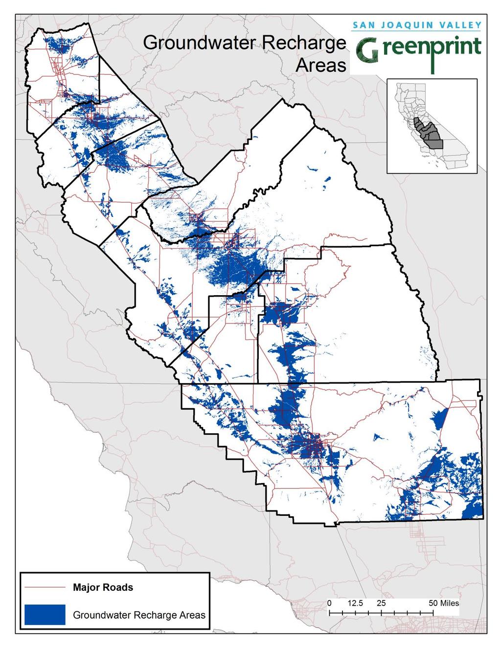
3 Note that the SJV Greenprint project does not endorse the use of these data layers for an authoritative projection of the impacts that cities and counties will be required to mitigate for. This is because the maps provided may be out of date, or may not have captured all the elements that a parcel-level inventory (as typically conducted as part of environmental mitigation) may find. Section 2 Description of the datasets provided This section identifies six GIS layers that are provided for use in the impact assessment, and two additional datasets that are still under evaluation. The data is accessible at: The themes for these datasets are: Currently Available Prime, Statewide, and Unique Importance Farmlands Grazing Lands Groundwater Recharge Areas Hardwoods Vernal Pools Critical Habitats Saline Soils Under Review Riparian For each of the layers, the paragraph below describes where the data to make the map came from, and how it was reviewed and compiled. In each case the data are from recognized national or state publications, and can reasonably be expected to be used in mitigation assessments. This means that the data are also useful in estimating impacts from preferred and alternate plans of urban development and transportation that are the result of the planning process for SCS. However, in many cases we simplified categories within the maps. This is because in some cases several maps were combined to create the layer provided here. Prime, Statewide, and Unique Importance Farmlands AND Grazing Lands Agricultural land, whether high capability crop lands or grazing and ranching lands are a key component to both the San Joaquin Valley s economy and its identity. Protecting space that supports both of these is a priority for the Sustainable Community Strategies across the San Joaquin Valley. These dataset P - 2
4 provide us with a basic outline of the lands that are of high importance for protecting and enhancing the regions agricultural identity and economy. Because grazing lands and farmlands were both identified in the input maps, these two categories are combined into the single GIS layer provided here. These are two independent datasets both derived from the 2010 Farmland Mapping and Monitoring (FMMP) dataset produced by the Division of Land Resource Protection in the California Department of Conservation. These two datasets are the result of merging the FMMP datasets for all 8 San Joaquin Valley Counties into a single dataset, reprojecting it to California Albers NAD83, and then extracting the polygons with polygon_ty (polygon type) in P, S, or U into the dataset called Prime_Statewide_Unique_Farmland.shp and polygon_ty = G into Grazing.shp. The following table lists the landcover types in the GIS layer, which can be analyzed as shown in the table in the first section. Dataset Polygon_type Name Prime_Statewide_Unique_Farmland.shp P Prime Importance Farmland Prime_Statewide_Unique_Farmland.shp S Statewide Importance Farmland Prime_Statewide_Unique_Farmland.shp U Unique Importance Farmland Grazing.shp G Grazing Groundwater Recharge Areas The San Joaquin Valley is a water limited region. Surface water availability can vary widely on an annual basis making ground water an essential component of the region s water supply. Implicit in this is the need to protect areas that contribute to recharging groundwater supplies. This dataset was derived by the California Water Institute from the NRCS SSURGO and STATSGO datasets based primarily on drainage class. Additional criteria based on slope and Storie Index were also used for some soil categories. This dataset is has only a single category indicating that the area is a likely recharge zone. Hardwoods Oak woodlands and other hardwood forests provide rich habitat for a wide range of species, both common and threatened or endangered. These oak woodlands serve as a transition and connectivity space between the valley floor and the higher elevations surrounding the Valley. As such they serve as a critical linkage for species, and are an opportunity area for developing guidance for creating compatibility between multiple uses. Several datasets were compared to aerial imagery to determine which one to use for a hardwood range map. These datasets were: A) the 2002 FRAP (State Department of Forestry and Fire Protection s Fire and Resource Assessment Program) Best available multi-source land cover; B) the 1990 FRAP Hardwood Rangeland Vegetation; C) the 2006 National Land Cover Database (NLCD 2006); and D) the 2010 California Augmented Multisource Land Cover Map (CAML), a UC Davis product. The 2002 FRAP Best P - 3
5 available multi-source land cover dataset was selected because it best matched the patterns seen in aerial imagery for hardwood woodlands and forests. The following California Wildlife Habitat Relationship System (WHR) landcover categories from the FRAP map were combined to create our hardwoods coverage: Blue-Oak-Foothill Pine (BOP), Blue Oak Woodland (BOW), Coastal Oak Woodland (COW), Montane Hardwood-Conifer (MHC), Montane Hardwood (MHW), Montane Riparian (MRI), Ponderosa Pine (PPN), Valley Oak Woodland (VOW), and Valley Foothill Riparian (VRI). Vernal Pool Complexes Vernal pools, gathered into groupings called complexes, are one of the most protected systems in the San Joaquin Valley. They are home to species that are listed under both the State and Federal Endangered Species Acts. Any further degradation to vernal pool habitats will be subject to intense scrutiny and will require costly mitigation. The Great Valley Vernal Pool Distribution GIS shapefile was created by Dr. Robert Holland and the Placer Land Trust. It contains coverage of vernal pool habitats for the baseline period ( ), 1997, and We used the 2005 data since it is the most recent. The original dataset had 9 vernal pool types that we condensed into 3 categories using the following crosswalk. Note that the 2005 map has some polygons that are labled Not Used. These represent areas that were not resurveyed, and we were recommended to use the 1997 attribute for those locations. Vernal Pool Type Description Category Cut-outs e.g. a cultivated field surrounded by habitat Present Low Density Pools are small, widely and patchily scattered. At least 2 and usually 5 or more pools within the delineated vernal pool complex Present Medium Density Pools are larger, more numerous, and more pervasively scattered, although still patchy within the delineated vernal pool complex Present High Density Pools are all sizes and numerous. Pools are distributed over the entire delineated vernal pool complex. Also includes large, isolated playa-like pools Present Cultivated Pools are present and persist in spite of cultivation, usually of dryfarmed hay or grain or in mowed areas adjacent to runways and landing strips Present with Disturbance Low Density with Disturbance Obvious signs of disturbance Present with Disturbance Medium Density with Disturbance Obvious signs of disturbance Present with Disturbance High Density with Disturbance Obvious signs of disturbance Present with Disturbance Former Habitat Former habitat now extirpated Former Habitat P - 4
6 Critical Habitats Critical Habitats are areas defined under the US Endangered Species Act(ESA) as essential to the recovery of species listed under the ESA. Development or disturbance of lands within these designated critical habitats will be costly and require substantial mitigation if it is feasible at all. This dataset was created by combining all available Critical Habitat datasets (as required for species recovery plans under the US Endangered Species Act) from the USFWS Critical Habitat Portal ( The boundaries were then dissolved to provide a single layer indicating whether an area is in at least one critical habitat definition. Saline Soils Saline soils represent potential locations where new urban growth would not adversely affect other resources in the valley. Therefore, saline soils can potenially be used in the opposite manner from other datasets in this collection, in that urban development on these lands is less likely to encounter regulatory requirements. The Saline Soils dataset provided is the result of an analysis done by the soil scientists at the Davis offices of the US Department of Agriculture, Natural Resource Conservation Service. The soil scientists wish to make it clear that while this is the best available information for planning purposes, but that the SSURGO dataset from which it is derived has been created from many data sources and with evolving methods. There are likely locations where the soil is either more saline than indicated or less for a variety of reasons including changes to the soil chemistry or error in mapping and measuring soil properties. The dataset is classified into the following categories of salinity as measured through the use of electrical conductivity. -1 Classes Electrical Condutivity (mmhos cm ) Moderately saline 8-16 Strongly saline 16 Riparian: Data only available for limited part of the San Joaquin Valley P-5
7 Like hardwoods, riparian areas are home to, preferred foraging grounds, and preferential dispersal habitats for many animal species. These lands also provide a wide variety of ecosystem services including (but not limited to) flood mitigation, groundwater recharge, water filtration, species habitat, foraging, movement, and reproduction, and scenic and recreational uses. On review of the available data there does not appear to be either a single sufficient dataset, or an appropriate combination of other available datasets that can be used that does not have either gaps in the data, or classification problems that render the data inappropriate for use. Suitable data is available for a subset of the area relating to the delta, but our opinion is that having a dataset for examination by the RTP/SCS process that does not cover the entire area is problematic. Notable areas of missing data include the Sierra Foothills and most of the Southern San Joaquin Valley. We include the data available with the caveat that where no riparian is mapped does not mean that no riparian is present. Graphics: P - 6

8 P - 7
9 P - 8

10 P - 9

11 P - 10

12 P - 11

13 P - 12
Summary Description Municipality of Anchorage. Anchorage Coastal Resource Atlas Project
 Summary Description Municipality of Anchorage Anchorage Coastal Resource Atlas Project By: Thede Tobish, MOA Planner; and Charlie Barnwell, MOA GIS Manager Introduction Local governments often struggle
Appendix 2b. NRCS Soil Survey
 Appendix 2b NRCS Soil Survey 118 19' 25'' W Nonirrigated Capability Class Antelope Valley Area, California (Del Sur Solar Site) 118 17' 28'' W 378900 379200 379500 379800 380100 380400 380700 381000 381300
Denis White NSI Technical Services Corporation 200 SW 35th St. Corvallis, Oregon 97333
 POLYGON OVERLAY TO SUPPORT POINT SAMPLE MAPPING: THE NATIONAL RESOURCES INVENTORY Denis White NSI Technical Services Corporation 200 SW 35th St. Corvallis, Oregon 97333 Margaret Maizel ' American Farmland
Ecological Land Cover Classification For a Natural Resources Inventory in the Kansas City Region, USA
 Ecological Land Cover Classification For a Natural Resources Inventory in the Kansas City Region, USA by Applied Ecological Services, Inc. In cooperation with the Mid-America Regional Council 600 Broadway,
Mapping and Modeling for Regional Planning
 Mapping and Modeling for Regional Planning Carol W. Witham Sacramento Valley Chapter California Native Plant Society contributors: David Ackerly John Dittes Julie Evens Josephine Guardino Robert F. Holland
3.3 CLIMATE, GEOLOGY, TOPOGRAPHY, AND SOILS CLIMATE GEOLOGY TOPOGRAPHY
 3.3 CLIMATE, GEOLOGY, TOPOGRAPHY, AND SOILS This section describes the climate, geology, topography, and soil resource characteristics of the Yolo Bypass Wildlife Area (Wildlife Area). Agricultural soil
Harrison 1. Identifying Wetlands by GIS Software Submitted July 30, ,470 words By Catherine Harrison University of Virginia
 Harrison 1 Identifying Wetlands by GIS Software Submitted July 30, 2015 4,470 words By Catherine Harrison University of Virginia cch2fy@virginia.edu Harrison 2 ABSTRACT The Virginia Department of Transportation
Great California Delta Trail Blueprint for Contra Costa and Solano Counties GIS AND MAPPING MEMORANDUM JULY 2010
 Great California Delta Trail Blueprint for Contra Costa and Solano Counties GIS AND MAPPING MEMORANDUM JULY 2010 {DRAFT} July 2010 Introduction Geographic Information Systems (GIS) are computer-based
Opportunities to Improve Ecological Functions of Floodplains and Reduce Flood Risk along Major Rivers in the Puget Sound Basin
 Opportunities to Improve Ecological Functions of Floodplains and Reduce Flood Risk along Major Rivers in the Puget Sound Basin Christopher Konrad, US Geological Survey Tim Beechie, NOAA Fisheries Managing
StreBanD DSS: A Riparian Buffer Decision Support System for Planners
 StreBanD DSS: A Riparian Buffer Decision Support System for Planners Dharmendra Saraswat Assoc. Prof,/Ext. Engineer- Geospatial 501-681-5987 (mobile) dsaraswat@uaex.edu Acknowledgment Project Team: Dr.
1.1 What is Site Fingerprinting?
 Site Fingerprinting Utilizing GIS/GPS Technology 1.1 What is Site Fingerprinting? Site fingerprinting is a planning tool used to design communities where protection of natural resources is the primary
Appendix I Feasibility Study for Vernal Pool and Swale Complex Mapping
 Feasibility Study for Vernal Pool and Swale Complex Mapping This page intentionally left blank. 0 0 0 FEASIBILITY STUDY BY GIC AND SAIC FOR MAPPING VERNAL SWALE COMPLEX AND VERNAL POOLS AND THE RESOLUTION
Native species (Forbes and Graminoids) Less than 5% woody plant species. Inclusions of vernal pools. High plant diversity
 Less than 5% woody plant species. Inclusions of vernal pools. High plant diversity") WILLAMETTE VALLEY WET-PRAIRIE RESTORATION MODEL WHAT IS A WILLAMETTE VALLEY WET-PRAIRIE Hot Spot s Native species (Forbes and Graminoids) Rare plant species Less than 5% woody plant species Often dominated
WILLAMETTE VALLEY WET-PRAIRIE RESTORATION MODEL WHAT IS A WILLAMETTE VALLEY WET-PRAIRIE Hot Spot s Native species (Forbes and Graminoids) Rare plant species Less than 5% woody plant species Often dominated
Web Soil Survey National Cooperative Soil Survey
 121 52' 18'' W Irrigated Capability Class Sutter County, California () 121 51' 49'' W 597600 597700 597800 597900 598000 598100 598200 39 6' 27'' N 39 6' 27'' N 39 5' 57'' N 4328400 4328500 4328600 4328700
Cripps Ranch 76+/- Acres Orchard Development Opportunity Dixon, CA. Presented By:
 Cripps Ranch 76+/- Acres Orchard Development Opportunity Dixon, CA Presented By: Cripps Ranch 76+/- Acres Orchard Development Opportunity Dixon, CA Location: This property is located at 5663 Dally Road
Steve Pye LA /22/16 Final Report: Determining regional locations of reference sites based on slope and soil type. Client: Sonoma Land Trust
 Steve Pye LA 221 04/22/16 Final Report: Determining regional locations of reference sites based on slope and soil type. Client: Sonoma Land Trust Deliverables: Results and working model that determine
Indicators of sustainable development: framework and methodologies CSD Indicators of sustainable development 1996
 Indicators of sustainable development: framework and methodologies CSD Indicators of sustainable development 1996 Keywords: mountain areas, mountain development, natural resources management, sustainable
Looking at the big picture to plan land treatments
 Looking at the big picture to plan land treatments Eva Strand Department of Rangeland Ecology and Management University of Idaho evas@uidaho.edu, http://www.cnr.uidaho.edu/range Why land treatment planning?
Carrick Road $798,000
 1955-2020 Carrick Road 165.76± acres Fayette/Scott Counties $798,000 Offered Exclusively By: Zach Davis Principal Broker +1.859.576.8195 www.kirkfarms.com zach@kirkfarms.com Measuring an appx. 165+/- acres,
Developing urban ecosystem accounts for Great Britain. Emily Connors Head of Natural Capital Accounting Office for National Statistics (UK)
") Developing urban ecosystem accounts for Great Britain Emily Connors Head of Natural Capital Accounting Office for National Statistics (UK) UN 2014 UN 2014 ONS 2017 UK motivation 54% 82% 5,900 Of the world
Developing urban ecosystem accounts for Great Britain Emily Connors Head of Natural Capital Accounting Office for National Statistics (UK) UN 2014 UN 2014 ONS 2017 UK motivation 54% 82% 5,900 Of the world
Southwest LRT Habitat Analysis. May 2016 Southwest LRT Project Technical Report
 Southwest LRT Habitat Analysis Southwest LRT Project Technical Report This page intentionally blank. Executive Summary This technical report describes the habitat analysis that was performed to support
POPULATION TRENDS FOR TULARE PSEUDOBAHIA AND STRIPED ADOBE LILY
 POPULATION TRENDS FOR TULARE PSEUDOBAHIA AND STRIPED ADOBE LILY Kern County has more endangered, threatened and rare plant species than most states. The geography and environmental conditions in the county
MARYLAND S LAND USE/LAND COVER MAP AND ASSOCIATED ANALYSIS
 MARYLAND S LAND USE/LAND COVER MAP AND ASSOCIATED ANALYSIS Maryland Department of Planning Daniel Baldwin Stephanie Martins November 19, 2012 http://www.planning.maryland.gov/ PURPOSE The primary purpose
Appendix J Vegetation Change Analysis Methodology
 Appendix J Vegetation Change Analysis Methodology Regional Groundwater Storage and Recovery Project Draft EIR Appendix-J April 2013 APPENDIX J- LAKE MERCED VEGETATION CHANGE ANALYSIS METHODOLOGY Building
Data Dictionary for Network of Conservation Areas Transcription Reports from the Colorado Natural Heritage Program
 Data Dictionary for Network of Conservation Areas Transcription Reports from the Colorado Natural Heritage Program This Data Dictionary defines terms used in Network of Conservation Areas (NCA) Reports
A Help Guide for Using gssurgo to Find Potential Wetland Soil Landscapes
 A Help Guide for Using gssurgo to Find Potential Wetland Soil Landscapes Wetland Mapping Consortium Webinar September 17, 2014 Dr. John M. Galbraith Crop & Soil Environmental Sciences Virginia Tech Wetland
Geospatial Data Sources. SLO GIS User Group June 8, 2010
 Geospatial Data Sources SLO GIS User Group June 8, 2010 Presenters Drew Decker USGS Southern California Geospatial Liaison Kelly Bobbitt Mike Bobbitt & Associates Joe Larson Cal Fire Peter Meertens Regional
Pierce Cedar Creek Institute GIS Development Final Report. Grand Valley State University
 Pierce Cedar Creek Institute GIS Development Final Report Grand Valley State University Major Goals of Project The two primary goals of the project were to provide Matt VanPortfliet, GVSU student, the
Landscape Planning and Habitat Metrics
 Landscape Planning and Habitat Metrics Frank W. Davis National Center for Ecological Analysis and Synthesis UC Santa Barbara (Tools for Landscape Biodiversity Planning) Jimmy Kagan Institute for Natural
DRAFT. REVISED Draft. Paso Robles Subbasin Groundwater Sustainability Plan Chapter 6
 REVISED Draft Paso Robles Subbasin Groundwater Sustainability Plan Chapter 6 Prepared for the Paso Robles Subbasin Cooperative Committee and the Groundwater Sustainability Agencies February 14, 2019 Paso
Appendix D. Sediment Texture and Other Soil Data
 5 6 7 8 Appendix D. Sediment Texture and Other Soil Data This appendix describes the sediment texture of the aquifer system in the Restoration Area. The contents of this appendix describe the: Importance
GOAL 7 AREAS SUBJECT TO NATURAL DISASTERS AND HAZARDS. To protect life and property from natural disasters and hazards.
 GOAL 7 AREAS SUBJECT TO NATURAL DISASTERS AND HAZARDS A. GOALS: To protect life and property from natural disasters and hazards. B. POLICIES: 1. Floodplains shall be maintained as natural drainage-ways.
Template for Sediment and Erosion Control Plan General Instructions. Section Instructions
 Template for Sediment and Erosion Control Plan General Instructions Introduction: Soil erosion and sediment deposition from farmlands can contribute to degraded surface water quality. Sediment delivery
Project Leader: Project Partners:
 UTILIZING LIDAR TO MAP HIGH PRIORITY WOODLAND HABITAT IN ARKANSAS DEVELOPING METHODOLOGY AND CONDUCTING A PILOT PROJECT IN THE OZARK HIGHLANDS TO MAP CURRENT EXTENT, SIZE AND CONDITION Project Summary
Wetland Mapping. Wetland Mapping in the United States. State Wetland Losses 53% in Lower US. Matthew J. Gray University of Tennessee
 Wetland Mapping Caribbean Matthew J. Gray University of Tennessee Wetland Mapping in the United States Shaw and Fredine (1956) National Wetlands Inventory U.S. Fish and Wildlife Service is the principle
Web Soil Survey National Cooperative Soil Survey
 122 14' 27'' W () 122 13' 37'' W 40 8' 40'' N 564700 564800 564900 565000 565100 565200 565300 565400 565500 565600 565700 565800 40 8' 40'' N 4443400 4443500 4443600 4443700 4443800 4443900 4444000 4443400
Physical Geography: Patterns, Processes, and Interactions, Grade 11, University/College Expectations
 Geographic Foundations: Space and Systems SSV.01 explain major theories of the origin and internal structure of the earth; Page 1 SSV.02 demonstrate an understanding of the principal features of the earth
ANCILLARY DATA VARIABLES
 ANCILLARY DATA VARIABLES PROCESSING INFORMATION AND MODELING USES Version 1.0 1 BACKGROUND The ancillary data component of the project included creation of a core dataset of 58 variables, of which 24 variables
Natural Resource Management. Northern Tasmania. Strategy. Appendix 2
 Natural Resource Management Strategy Northern Tasmania 2015 2020 Appendix 2 Appendix 2 Appendix 2. Carbon Planting Spatial Prioritisation In support of this Strategy s development and implementation, work
Quality and Coverage of Data Sources
 Quality and Coverage of Data Sources Objectives Selecting an appropriate source for each item of information to be stored in the GIS database is very important for GIS Data Capture. Selection of quality
4.11 CULTURAL RESOURCES
 4.11 CULTURAL RESOURCES 4.11 CULTURAL RESOURCES This section summarizes the cultural resources of. Information reviewed for the summary includes the General Plan, published reports on archaeological research
The Road to Data in Baltimore
 Creating a parcel level database from high resolution imagery By Austin Troy and Weiqi Zhou University of Vermont, Rubenstein School of Natural Resources State and local planning agencies are increasingly
Accounting Units for Ecosystem Accounts Paper prepared by Alessandra Alfieri, Daniel Clarke, and Ivo Havinga United Nations Statistics Division
 DEPARTMENT OF ECONOMIC AND SOCIAL AFFAIRS STATISTICS DIVISION UNITED NATIONS Expert Meeting on Ecosystem Accounts London, UK 5-7 December 2011 Accounting Units for Ecosystem Accounts Paper prepared by
The Invasion of False Brome in Western Oregon
 The Invasion of False Brome in Western Oregon GIS II Presentation Winter 2006 Will Fellers Kurt Hellerman Kathy Strope Statia Cupit False Brome (Brachypodium sylvaticum) Perennial bunchgrass native to
Baseline Estuarine-Upland Transition Zone
 Baseline Estuarine-Upland Transition Zone in SF, San Pablo and Suisun Bays 10/5/18 Prepared for San Francisco Bay Joint Venture (SFBJV) Prepared by Brian Fulfrost, Principal bfaconsult@gmail.com with additional
Application of GIS and remote sensing in conservation of vernal pools
 Priyanka Patel NRS 509 12/16/2014 Application of GIS and remote sensing in conservation of vernal pools Vernal pools are small temporary water bodies that contain water for some parts of the year. They
Statewide wetland geospatial inventory update
 Statewide wetland geospatial inventory update Factsheet 1: Outcomes from the statewide wetland geospatial inventory update 1 Introduction In 2011 the Victorian Department of Environment and Primary Industries
The Contested Cultural Landscape of a Lebanese Border Town: MARJA AYOUN
 The Contested Cultural Landscape of a Lebanese Border Town: MARJA AYOUN IBD 2013 FNAS MAY 2013 Dr. Christine Mady, City & Regional Planning NDU -FAAD In this Presentation A PLANNING PERSPECTIVE INTRODUCING
Figure 1: Mapping occurrences on USGS topographic maps. Needs Figure 2: Comparison of buffered points and digitized occurrence boundaries
 Using Geographic Information Systems to Prepare Sensitive Species Information for Land Use Master Planning Ed Schools, Helen Enander, and John Paskus MSU Extension, Michigan Natural Features Inventory
Mineral Resources
 Sacramento Local Agency Formation Commission Mineral Resources 3.11 - Mineral Resources 3.11.1 - Introduction This section describes and evaluates potential environmental impacts to mineral resources resulting
Atlas of the Upper Gila River Watershed
 Atlas of the Upper Gila River Watershed Katie Banister, David Chan, Jessica M. Driscoll, Christopher Fullerton, Aaron Lien and Kelly Mott Lacroix January 2014 The University of Arizona Water Resources
Distinct landscape features with important biologic, hydrologic, geomorphic, and biogeochemical functions.
 1 Distinct landscape features with important biologic, hydrologic, geomorphic, and biogeochemical functions. Have distinguishing characteristics that include low slopes, well drained soils, intermittent
VCS MODULE VMD0018 METHODS TO DETERMINE STRATIFICATION
 VMD0018: Version 1.0 VCS MODULE VMD0018 METHODS TO DETERMINE STRATIFICATION Version 1.0 16 November 2012 Document Prepared by: The Earth Partners LLC. Table of Contents 1 SOURCES... 2 2 SUMMARY DESCRIPTION
Geospatial Data, Services, and Products. National Surveying, mapping and geospatial conference
 Geospatial Data, Services, and Products Federal Programs -- USDA NRCS National Surveying, mapping and geospatial conference March 15, 2016 NRCS Applications using Geosaptial Products & Services Field
High Speed / Commuter Rail Suitability Analysis For Central And Southern Arizona
 High Speed / Commuter Rail Suitability Analysis For Central And Southern Arizona Item Type Reports (Electronic) Authors Deveney, Matthew R. Publisher The University of Arizona. Rights Copyright is held
Watershed concepts for community environmental planning
 Purpose and Objectives Watershed concepts for community environmental planning Dale Bruns, Wilkes University USDA Rural GIS Consortium May 2007 Provide background on basic concepts in watershed, stream,
Using Grassland Vegetation Inventory Data
 Adam Moltzahn Eastern Short-Horned Lizard Using Grassland Vegetation Inventory Data The GVI represents the Government of Alberta s comprehensive biophysical, anthropogenic and land-use inventory of the
GREEN GROWTH TOOLBOX. Nature-Friendly Planning. Jeff Marcus North Carolina Wildlife Resources Commission
 GREEN GROWTH TOOLBOX Nature-Friendly Planning Jeff Marcus North Carolina Wildlife Resources Commission Growth in North Carolina NC is the 5 th fastest growing state 3 million people will move to NC over
GIS in Community & Regional Planning
 GIS in Community & Regional Planning The The role role of of GIS GIS in in Re-writing the the Zoning Bylaw for for the the City City of of Vernon LandInfo Technologies Presentation Overview The GIS Initiative
Partnering with LANDFIRE, NatureServe, and Heritage Programs. Utilizing Legacy Data for Ecological Site Concept Development and Descriptions
 Partnering with LANDFIRE, NatureServe, and Heritage Programs Utilizing Legacy Data for Ecological Site Concept Development and Descriptions Content LANDFIRE: BpS vs. EVT LANDFIRE: Disturbance Models NatureServe:
Wetland Mapping & Functional Assessment Canadian River Watershed New Mexico. Association of State Wetland Managers
 Wetland Mapping & Functional Assessment Canadian River Watershed New Mexico Association of State Wetland Managers November, 2012 Approach for this project based on: EPA 2006 Document: Application of Elements
Web Soil Survey National Cooperative Soil Survey
 252500 252600 252700 252800 252900 253000 253100 83 47' 15'' W 83 47' 49'' W Nonirrigated Capability Class Jackson and Owsley Counties, Kentucky (Peggy Wilson Booneville Property - ) 253200 253300 37 25'
Chapter 6. Fundamentals of GIS-Based Data Analysis for Decision Support. Table 6.1. Spatial Data Transformations by Geospatial Data Types
 Chapter 6 Fundamentals of GIS-Based Data Analysis for Decision Support FROM: Points Lines Polygons Fields Table 6.1. Spatial Data Transformations by Geospatial Data Types TO: Points Lines Polygons Fields
TOWARDS CLIMATE-RESILIENT COASTAL MANAGEMENT: OPPORTUNITIES FOR IMPROVED ICZM IN BELIZE
 TOWARDS CLIMATE-RESILIENT COASTAL MANAGEMENT: OPPORTUNITIES FOR IMPROVED ICZM IN BELIZE CHANTALLE SAMUELS Coastal Zone Management Authority and Institute The Caribbean Community Climate Change Centre VULNERABILITY
Land Use MTRI Documenting Land Use and Land Cover Conditions Synthesis Report
 Colin Brooks, Rick Powell, Laura Bourgeau-Chavez, and Dr. Robert Shuchman Michigan Tech Research Institute (MTRI) Project Introduction Transportation projects require detailed environmental information
DST MODEL SUPPORT SPATIAL DATA AND WATER RIGHTS INFORMATION. Tim Minor, Desert Research Institute
 DST MODEL SUPPORT SPATIAL DATA AND WATER RIGHTS INFORMATION Tim Minor, Desert Research Institute THIS PAGE INTENTIONALLY LEFT BLANK ii TABLE OF CONTENTS LIST OF FIGURES... iii INTRODUCTION... 1 PHASE III
Examples of How Aerial Imagery Is Used in North Carolina. October 2007
 Examples of How Aerial Imagery Is Used in North Carolina October 2007 Table of Contributors Asheville Stormwater Utility Billing Camden County Tracking Permit Violations on Land Clearings CGIA Delineating
NOAA s OCM: Services, tools and collaboration opportunities & Puerto Rico s NE Marine Corridor as a case study
 NOAA s OCM: Services, tools and collaboration opportunities & Puerto Rico s NE Marine Corridor as a case study Dr. Antares Ramos Álvarez NOAA s Office of Coastal Management September 15 th, 2016 Conservation
GIS Data, Technology, and Models. to Integrate Information and Improve Transportation Decision-Making. within the Eco-Logical* Framework for Oregon
 GIS Data, Technology, and Models to Integrate Information and Improve Transportation Decision-Making within the Eco-Logical* Framework for Oregon GIS-T 2009, Oklahoma City, OK April 8, 2009, Session 5..2.2
Ecological Site Description Overview
 Ecological Site Description Overview 2018 Coastal Zone Soil Survey (CZSS) Work Planning Conference Savannah, GA January 9th, 2018 Greg Taylor Senior Regional Soil Scientist USDA-NRCS Raleigh, NC j.greg.taylor@nc.usda.gov
United States Department of the Interior NATIONAL PARK SERVICE Northeast Region
 United States Department of the Interior NATIONAL PARK SERVICE Northeast Region June 17, 2017 REQUEST FOR STATEMENTS OF INTEREST and QUALIFICATIONS Project Title: ASSESSMENT OF NATURAL RESOURCE CONDITION
J.H. Campbell Generating Facility Pond A - Location Restriction Certification Report
 J.H. Campbell Generating Facility Pond A - Location Restriction Certification Report Pursuant to: 40 CFR 257.60 40 CFR 257.61 40 CFR 257.62 40 CFR 257.63 40 CFR 257.64 Submitted to: Consumers Energy Company
Global reviews of wetland inventory, classification and delineation
 Max Finlayson Institute for Land, Water & Society Charles Sturt University Albury, Australia Global reviews of wetland inventory, classification and delineation Initiatives/meetings over two decades have
ARCH PROJET Activity 1 -Synthesis-
 ARCH PROJET Activity 1 -Synthesis- CONTENT 1 ARCH project context... 3 1.1. General context... 3 1.2. The ARCH Project... 3 1.3. The Project ARCH partners... 3 1.4. The ARCH project content... 4 2 Activity
Land Accounts - The Canadian Experience
 Land Accounts - The Canadian Experience Development of a Geospatial database to measure the effect of human activity on the environment Who is doing Land Accounts Statistics Canada (national) Component
Data sources and classification for ecosystem accounting g
 Data sources and classification for ecosystem accounting Ken Bagstad 23 February 2015 Wealth Accounting and the Valuation of Ecosystem Services www.wavespartnership.org Data sources and classification
Name NRS 409 Exam I. 1. (24 Points) Consider the following questions concerning standard data for GIS systems.
 Consider the following questions concerning standard data for GIS systems.") Read every question carefully. You may use a calculator if you wish. Conversion tables are provided at the end of the exam. If you have any questions, raise your hand. Be sure to show your work on computational
Read every question carefully. You may use a calculator if you wish. Conversion tables are provided at the end of the exam. If you have any questions, raise your hand. Be sure to show your work on computational
The use and applications of the Soilscapes datasets
 The use and applications of the Soilscapes datasets National Soil Resources Institute Timothy S. Farewell Ian G. Truckell Caroline A. Keay Stephen H. Hallett July 2011 The Soilscapes Dataset Edition 1
PRELIMINARY WORKING DRAFT Work in Progress
 IV. ENVIRONMENTAL IMPACT ANALYSIS H. MINERAL RESOURCES 1.0 INTRODUCTION This section addresses the potential impacts of the Proposed Project on mineral resources (i.e., sand, gravel and petroleum). The
FR Exam 2 Substitute Project!!!!!!! 1
 FR5131 - Exam 2 Substitute Project!!!!!!! 1 Goal We seek to identify county lands that both protect vernal pools and riparian corridors, and that provide open space and recreation within easy reach of
LANDUSE APPLICATIONS OF EARTHQUAKE HAZARD MAPS CALIFORNIA EXPERIENCE
 LANDUSE APPLICATIONS OF EARTHQUAKE HAZARD MAPS CALIFORNIA EXPERIENCE Thomas C. Vlasic Vice President Spangle Associates Portola Valley, California INTRODUCTION The focus of this report is primarily on
Directed Reading. Section: Types of Maps
 Skills Worksheet Directed Reading Section: Types of Maps 1. What are some of the characteristics of an area shown on maps used by Earth scientists? a. types of animals, types of plants, types of minerals
15 March 2010 Re: Draft Native Vegetation of the Sydney Metropolitan Catchment Management Authority Area GIS layers and explanatory reports
 SYDNEY COASTAL COUNCILS GROUP Inc. C/- City of Sydney Council Level 14, 456 Kent Street GPO Box 1591, SYDNEY NSW 2001 Phone: (02) 9246 7791 Facsimile: (02) 9265 9660 Email: info@sydneycoastalcouncils.com.au
Savannah District s Revised SOP: Moving Towards A Functional Approach. US Army Corps of Engineers BUILDING STRONG
 Savannah District s Revised SOP: Moving Towards A Functional Approach US Army Corps of Engineers Agenda SOP Revision Concept New Aquatic Resource Credit Types New Urban Mitigation Service Area Filter Background
The following maps must be provided as a part of the ADA. The appropriate scale for each map should be determined at the pre application conference.
 Main Street @ Coconut Creek DRI QUESTION 9 MAPS The following maps must be provided as a part of the ADA. The appropriate scale for each map should be determined at the pre application conference. Map
Land Cover Classification Mapping & its uses for Planning
 Land Cover Classification Mapping & its uses for Planning What is Land Cover Classification Mapping? Examples of an actual product Why use Land Cover Classification Mapping for planning? Possible uses
ADMINISTRATION DEPARTMENT Land Management Information Center. An Inventory of Its Records
 MINNESOTA HISTORICAL SOCIETY Minnesota State Archives ADMINISTRATION DEPARTMENT Land Management Information Center An Inventory of Its Records OVERVIEW OF THE RECORDS Agency: Series Title: Land Management
SEEA Experimental Ecosystem Accounting
 SEEA Experimental Ecosystem Accounting Sokol Vako United Nations Statistics Division Training for the worldwide implementation of the System of Environmental Economic Accounting 2012 - Central Framework
EBA Engineering Consultants Ltd. Creating and Delivering Better Solutions
 EBA Engineering Consultants Ltd. Creating and Delivering Better Solutions ENHANCING THE CAPABILITY OF ECOSYSTEM MAPPING TO SUPPORT ADAPTIVE FOREST MANAGEMENT Prepared by: EBA ENGINEERING CONSULTANTS LTD.
Presented by: Bryan Bloch GIS Specialist DNREC Division of Watershed Stewardship
 Presented by: Bryan Bloch GIS Specialist DNREC Division of Watershed Stewardship Bryan Hall, AICP Sussex County Circuit Rider Planner, Office of State Planning Coordination, OMB November 19, 2012 UD Sustainable
CHAPTER 12: TERRESTRIAL LAYERS
 CHAPTER 12: TERRESTRIAL LAYERS Coordinator: Shannon McElvaney Hawai`i Natural Heritage Program mcelvane@hawaii.edu Theme Description: Land use corresponds to the socio-economic description (or functional
Brief for Habitat and Boundary survey and action plans
 Brief for Habitat and Boundary survey and action plans Introduction The Forest of Bowland Area of Outstanding Natural Beauty (AONB) is the lead partner of the proposed Pendle Hill Landscape Partnership
1:30 2:00 Tangible Examples of NVC Uses from Monitoring, Mapping, and Habitat Modeling. (Todd Keeler- Wolf, ESA Panel)
") 1:30 2:00 Tangible Examples of NVC Uses from Monitoring, Mapping, and Habitat Modeling. (Todd Keeler- Wolf, ESA Panel) Habitat Modeling for Mojave Ground Squirrel: a rare species of the Western Mojave
1:30 2:00 Tangible Examples of NVC Uses from Monitoring, Mapping, and Habitat Modeling. (Todd Keeler- Wolf, ESA Panel) Habitat Modeling for Mojave Ground Squirrel: a rare species of the Western Mojave
The Refugia Concept: Using Watershed Analysis to Prioritize Salmonid Habitat for Conservation and Restoration
 The Refugia Concept: Using Watershed Analysis to Prioritize Salmonid Habitat for Conservation and Restoration Christopher May Battelle & UW Cumulative Impacts of Urbanization Landscape Alterations Loss
Introduction. Project Summary In 2014 multiple local Otsego county agencies, Otsego County Soil and Water
 Introduction Project Summary In 2014 multiple local Otsego county agencies, Otsego County Soil and Water Conservation District (SWCD), the Otsego County Planning Department (OPD), and the Otsego County
Evaluating Wildlife Habitats
 Lesson C5 4 Evaluating Wildlife Habitats Unit C. Animal Wildlife Management Problem Area 5. Game Animals Management Lesson 4. Evaluating Wildlife Habitats New Mexico Content Standard: Pathway Strand: Natural
CHAPTER 7 PRODUCT USE AND AVAILABILITY
 CHAPTER 7 PRODUCT USE AND AVAILABILITY Julie Prior-Magee Photo from SWReGAP Training Site Image Library Recommended Citation Prior-Magee, J.S. 2007. Product use and availability. Chapter 7 in J.S. Prior-Magee,
A Comprehensive Inventory of the Number of Modified Stream Channels in the State of Minnesota. Data, Information and Knowledge Management.
 A Comprehensive Inventory of the Number of Modified Stream Channels in the State of Minnesota Data, Information and Knowledge Management Glenn Skuta Environmental Analysis and Outcomes Division Minnesota
FESTF Gopher. A Data Integration Tool to Inform Decisions in FIFRA/ESA Processes
 FESTF Gopher A Data Integration Tool to Inform Decisions in FIFRA/ESA Processes April 26, 2018 CropLife America & RISE Regulatory Conference Arlington, VA An Introduction to FESTF The (FESTF), incorporated
Fig 1. Steps in the EcoValue Project
 Assessing the Social and Economic Value of Ecosystem Services in the Northern Forest Region: A Geographic Information System (GIS) Approach to Landscape Valuation Principal Investigator(s): Dr. Matthew