GIS in Community & Regional Planning
|
|
|
- Asher Cross
- 5 years ago
- Views:
Transcription
1 GIS in Community & Regional Planning The The role role of of GIS GIS in in Re-writing the the Zoning Bylaw for for the the City City of of Vernon LandInfo Technologies
2 Presentation Overview The GIS Initiative at the City of Vernon Re-writing the Zoning Bylaw with GIS Assessing the GIS Contribution to the Project


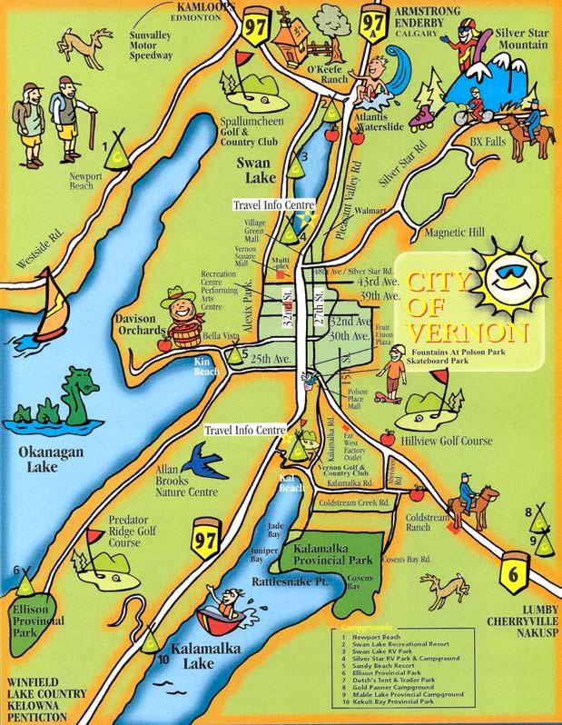
3 City of Vernon Location Population Economic Base Base Attractions Growth Greater Vernon Initiatives
4 Renewed GIS Focus The The City City has has been using GIS GIS for for a number of of years Initial focus was was on on data capture and and inventory A renewed effort to to use use GIS GIS technology to to its its full full potential; provide cost cost savings while enhancing the the City s efficiency and and service provision New focus on on data retrieval - view, query & reporting - with emphasis on on web-based mapping technology
5 Municipal GIS GIS System live live data data inventory linked linked databases internet mapping integrated information management mobile wireless technology Municipal GIS GIS Mapping Applications & Services for for Staff & Clients Cost Savings Public Access 24 7 Goals for GIS
6 Multiple Access Levels City City Intranet linked linked internal municipal access access to to all all data data City City Extranet external access access to to password restricted specific city city data data Public Internet free free public public access access to to limited city city data data
7 The Zoning Bylaw & GIS The The revision of of the the Zoning Bylaw was was an an ideal opportunity to to use use GIS GIS GIS GIS technology was was used to to capture data data using using web-based GIS GIS technology analyze existing data data sets sets produce new new zoning zoning allocations through planning scenarios distribute proposed zoning zoning to to the the public public through a web-based mapping interface EKISTICS Town Planning and and LandInfo Technologies are are currently developing the the 2 nd nd Draft of of the the Bylaw for for public review
8 Zoning s Strategic Role Zoning Bylaws play play a strategic role role in in determining how how a community grows and and develops. Zoning establishes the the legally binding framework for for administering land uses and and regulating development. It It provides stability in in land uses and and certainty for for land owners. Zoning, however, can can also also act act as as a barrier to to economic investment and and as as an an impediment to to implementing innovations in in community and and regional planning.
9 Re-writing the Zoning Bylaw The The revision of of Vernon s Zoning Bylaw N o. o sought to to Consolidate two two existing Zoning Bylaws Streamline the the Zoning Bylaw Bylaw categories Reflect OCP OCP policy policy recommendations Implement complete community planning principles Apply Apply GIS GIS technology in in the the City City

10 The Function of Zoning Minimize adverse impacts on on adjacent properties Encourage coherent development patterns Provide for for appropriate use use of of land land Protect public public health health and and safety safety Promote easy easy movement from from place place to to place place Preserve the the character of of distinct areas areas
11 The Scale of Zoning Municipalities employ a variety of of planning tools across a range of of scales Zoning regulates at at an an intermediate parcel scale between OCP OCP policy and and physical form Complementary Bylaws parking landscape signage noise noise runoff runoff control

12 Zoning Regulates Land Land Uses Uses Parcel Parcel Size Size Building Area Area Building Setbacks Building Height Height Landscape Parking & Access

13 Zoning Protects Riparian Habitat Aquatic Ecosystems Terrestrial Ecosystems Floodplains Hillside Slopes Slopes Highways Corridors

14 INPUTS Zoning Bylaw Project Staff Staff Project Project Start-up Start-up Staff Staff Project Project Start-up Start-up Workshops: Workshops: - Council - Agencies - Council - Public - Agencies - Development - Public - Community Development Community Staff Staff Workshop Workshop Agency Agency Referrals Referrals Public Public Hearing Hearing Request Request for Proposal for Proposal Review Review Proposal Proposal ANALYSIS ANALYSIS OF THE OF THE PRESENT: PRESENT: Data Inventory & Data Inventory & Consolidation Consolidation FORGING FORGING A A FRAMEWORK: FRAMEWORK: Researching Researching Precedents Precedents DRAFTING DRAFTING THE THE FUTURE: FUTURE: Preparing Preparing The Bylaw The Bylaw ADOPTING ADOPTING THE THE VISION: VISION: Bylaw Approval Bylaw Approval Process Process PUBLISHING PUBLISHING THE THE BYLAW BYLAW DECISIONS Appointment of Appointment of Consultant Consultant Review Review Draft Bylaw Draft Bylaw by Council by Council Final Review Final Review of Draft Bylaw of Draft Bylaw th 4 th Reading & 4 Reading & Bylaw Bylaw Adoption Adoption Data Data Capture Capture Data Data Analysis Analysis Planning Planning Scenarios Scenarios Public Public Review Review Counter Counter Query Query GIS Support

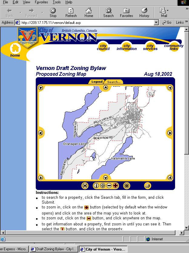
15 The Role of GIS The The project used GIS GIS to to capture parcel parcel information analyze data data to to produce new new planning scenarios distribute proposed zoning zoning to to the the public public through a web-based mapping interface And And once once adopted, the the new new Zoning Bylaw Bylaw will will be be stored, up-dated and and reproduced using using GIS GIS
16 Data Capture GIS web-based technology was used to compile (MapGuide) Land parcel information the basic building blocks of the database - using BC Assessment & City information Verify existing zoning & land use Assign OCP designations Overlay existing zoning and additional land use layers such as ALR and floodplain Integrate new information within the existing City parcel datasets
17 Capture Parcel Information Highway th Ave


18 Verify Actual Land Use Highway th Ave
19 Assign OCP Designations To be confirmed Airport Industrial Commercial Community Highway 97 Downtown Creekside Redevelopment Light Industrial Parks and Open Space Public and Institutional Rural Agricultural 25 th Ave Residential High Density Residential Low Density Residential Medium Density Commercial Tourist Commercial Urban Commercial - Village
20 C1 C1 Overlay Zoning 25 th Ave Highway 97 Highway Highway C2 C2 RM2 R2 R2 To be confirmed Airport Industrial Commercial Community Downtown Creekside Redevelopment Light Industrial Parks and Open Space Public and Institutional Rural Agricultural R2 R2 P1 P th th P2 P2 Ave Ave M1 M1 R1 R1 Residential High Density Residential Low Density Residential Medium Density Commercial Tourist Commercial Urban Commercial - Village
21 Data Analysis GIS technology (MapInfo) was used to analyze data landscape & contours existing land use flag parcels with floodplain, ALR and stream setbacks zoning and OCP correspondence
22 Analyze Landscape Features 15m stream buffer Affected Property
23 Analyze Zoning & OCP Correspondence Commercial Community Downtown Creekside Redevelopment Parks and Open Space Public and Institutional Residential High Density Residential Medium Density Commercial Tourist Commercial Urban Commercial - Village
24 Planning Scenarios GIS GIS technology (MapInfo) was was also also used to to Identify areas areas in in which which the the current zoning zoning did did not not match match the the OCP OCP designation Recommend new new zoning zoning to to suit suit these these areas areas Revise Revise existing zones zones to to reflect reflect applicable OCP OCP policies and and planning innovations
25 Initial SQL Scenario Legend Multiple Designation Airport Industrial Community Commercial Creekside Redevelopment Light Industrial/Service Commercial Park Public and Institutional Rural Agricultural Residential - High Density Residential - Low Density Residential - Medium Density Commercial - Tourist Commercial - Urban Commercial - Village
26 Refined Complex SQL Legend: Zoning Scenarios, July 19, 2002 Not Assigned A1 Agriculture - ALR A2 Agriculture - Large Lot A3 Agriculture - Small Lot C1 Commercial - Urban C2 Commercial - Urban C3 Commercial - Automobile Oriented C4 Commercial - Street Oriented C5 Commercial - Village C6 Commercial - Tourist C7 Commercial - 27th Street C8 Commercial - Neighbourhood CD1 CD1 CD2 Predator Ridge - Commercial Zoning CD3 Predator Ridge - Residential Zoning CRD Creekside Redevelopment Area CS1 Commercial - Service CS2 Commercial - High-Tech Service I1 Industrial - Light I2 Industrial - Airport I3 Industrial - Industrial Park I4 Industrial - Heavy P1 Parks and Open Space P2 Institutional - Schools and Churches P3 Institutional - Other RH1 Residential - Low-Rise Apartment RH2 Residential - Stacked Rowhouse RH3 Residential - High Rise Apartment RL1 Residential - Duplex and Townhouse RL2 Residential - Detached 12 m wide lots RL3 Residential - Detached 15 m wide lots RL4 Residential - Detached 18 m wide lots RL5 Residential - Detached 24 m wide lots RL6 Residential - Mobile Home RL7 Residential - Lakeshore RL8 Residential - 1 acre lots RM1 Residential - Medium Density RM2 Residential - Rowhouse RS1 Residential - Detached with secondary suite
27 Overlay Unique Allocations by Hand Legend: Zoning Scenarios, July 19, 2002 Not Assigned A1 Agriculture - ALR A2 Agriculture - Large Lot A3 Agriculture - Small Lot C1 Commercial - Urban C2 Commercial - Urban C3 Commercial - Automobile Oriented C4 Commercial - Street Oriented C5 Commercial - Village C6 Commercial - Tourist C7 Commercial - 27th Street C8 Commercial - Neighbourhood CD1 CD1 CD2 Predator Ridge - Commercial Zoning CD3 Predator Ridge - Residential Zoning CRD Creekside Redevelopment Area CS1 Commercial - Service CS2 Commercial - High-Tech Service I1 Industrial - Light I2 Industrial - Airport I3 Industrial - Industrial Park I4 Industrial - Heavy P1 Parks and Open Space P2 Institutional - Schools and Churches P3 Institutional - Other RH1 Residential - Low-Rise Apartment RH2 Residential - Stacked Rowhouse RH3 Residential - High Rise Apartment RL1 Residential - Duplex and Townhouse RL2 Residential - Detached 12 m wide lots RL3 Residential - Detached 15 m wide lots RL4 Residential - Detached 18 m wide lots RL5 Residential - Detached 24 m wide lots RL6 Residential - Mobile Home RL7 Residential - Lakeshore RL8 Residential - 1 acre lots RM1 Residential - Medium Density RM2 Residential - Rowhouse RS1 Residential - Detached with secondary suite
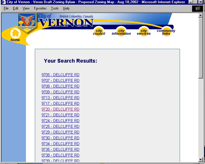
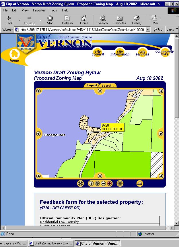
28 Public Review GIS GIS technology was was then used to to produce the the digital digital zoning zoning maps maps and and text text for for viewing on on the the internet provide public public access access to to the the draft draft zoning zoning bylaw bylaw through the the internet on on the the city s city s web-page provide public public feedback form form on on the the web web for for public public and and agency comment
29

30

31

32

33
34
35
36 Advantages Assessing Data Capture Web interface worked well - providing real time data access, edit & viewing from different locations with different users GIS saved time through capturing data using existing BC Assessment role data & integrating it with City data Aerial images with cadastral base were used extensively to verify land use and to get a feel for surrounding land uses without field investigation GIS was fast saving time, money while exceeding client expectations Disadvantages BC Assessment data compatibility with accurate city data Speed when viewing large images (web based)
37 Advantages Assessing Analysis & Scenarios Relatively easy to use: Any commercial desk top GIS ideally suited (e.g. MapInfo or ArcView) standard software Scenarios were generated through SQL queries easy to save & rerun once created Aerial images were used extensively to verify land use and to get a feel for surrounding land uses without on-site inspection Select and buffer tools worked well to establish overlay zones that the City had not yet mapped
38 Assessing Mapping on Public Web Site Advantages Cost savings immediate & longterm Info access & dissemination 24 7 Convenience Quality & accuracy of information Disadvantages New technology: Public not GIS literate or familiar with maps on the Internet Newsletters and local news newspapers to inform public Front Counter land owner education
39 In In 2003, the the City s GIS GIS system will will be be able able to to The Future maintain and and reproduce the the digital digital zoning zoning maps maps and and text text for for municipal & public public use use (Counter Query) provide public public access access to to a variety of of parcel parcel and and municipal data data from from any any internet connection provide an an integrated inventory and and analysis tool tool for for planning and and municipal management mobile technology bringing GIS GIS to to the the field field
40 GIS in Community & Regional Planning The The role role of of GIS GIS in in Re-writing the the Zoning Bylaw for for the the City City of of Vernon LandInfo Technologies
Proposed Scope of Work Village of Farmingdale Downtown Farmingdale BOA Step 2 BOA Nomination Study / Draft Generic Environmental Impact Statement
 Proposed Scope of Work Village of Farmingdale Downtown Farmingdale BOA Step 2 BOA Nomination Study / Draft Generic Environmental Impact Statement The scope of work that follows incorporates and covers
Bridging the Gap between Engineering and GIS
 Bridging the Gap between Engineering and GIS Presented by: Karen Stewart, B.Tech, GISP Manager of Geomatics Township of Langley February 13, 2006 Agenda Introduction History Goals Implementation Benefits
City of Manitou Springs
 March 2018 City of Manitou Springs Implementing Land Use tools to reduce and mitigate natural hazard risk Context & History Past Present Historic homes Older infrastructure Hillside development Creekside
 3 4 5 6 7 8 9 10 11 12 13 14 15 16 17 REDCLIFF MUNICIPAL PLANNING COMMISSION FOR COMMENT/DISCUSSION DATE: TOPIC: April 27 th, 2018 Bylaw 1860/2018, proposed amendments to the Land Use Bylaw regarding cannabis
Albuquerque City-wide Zoning Remapping
 Albuquerque City-wide Zoning Remapping Michelle Gricius, City of Albuquerque Planning Department Albuquerque Geographic Information System (AGIS) Division City of Albuquerque Annexation History Albuquerque
TREASURE COAST REGIONAL PLANNING COUNCIL M E M O R A N D U M. To: Council Members AGENDA ITEM 4B10
 TREASURE COAST REGIONAL PLANNING COUNCIL M E M O R A N D U M To: Council Members AGENDA ITEM 4B10 From: Date: Subject: Staff December 14, 2018 Council Meeting Local Government Comprehensive Plan Review
Write a report (6-7 pages, double space) on some examples of Internet Applications. You can choose only ONE of the following application areas:
 on some examples of Internet Applications. You can choose only ONE of the following application areas:") UPR 6905 Internet GIS Homework 1 Yong Hong Guo September 9, 2008 Write a report (6-7 pages, double space) on some examples of Internet Applications. You can choose only ONE of the following application
UPR 6905 Internet GIS Homework 1 Yong Hong Guo September 9, 2008 Write a report (6-7 pages, double space) on some examples of Internet Applications. You can choose only ONE of the following application
Date: June 19, 2013 Meeting Date: July 5, Consideration of the City of Vancouver s Regional Context Statement
 Section E 1.5 To: From: Regional Planning and Agriculture Committee Lee-Ann Garnett, Senior Regional Planner Planning, Policy and Environment Department Date: June 19, 2013 Meeting Date: July 5, 2013 Subject:
CERTIFIED RESOLUTION. introduction: and dated May 29, 2017, as attached, as appropriate
 15322 Buena Vista Avenue, White Rock BC, Canada V4B 1Y6 www.whiterockcity.ca City of White Rock P: 604.541.22121 F: 604.541.9348 /2tC% City Clerk s Office IT E ROC K June 13,2017 Stephanie Lam, Deputy
Public Transportation Infrastructure Study (PTIS) - 2 nd Technical Advisory Committee Meeting
 - 2 nd Technical Advisory Committee Meeting") Public Transportation Infrastructure Study (PTIS) - 2 nd Technical Advisory Committee Meeting Presentation to: Technical Advisory Committee (TAC) Presented by: and Team July 8th, 2009 Public Transportation
Public Transportation Infrastructure Study (PTIS) - 2 nd Technical Advisory Committee Meeting Presentation to: Technical Advisory Committee (TAC) Presented by: and Team July 8th, 2009 Public Transportation
CORPORATION OF THE CITY OF COURTENAY COUNCIL MEETING AGENDA
 CORPORATION OF THE CITY OF COURTENAY COUNCIL MEETING AGENDA DATE: Monday, January 14, 2013 PLACE: City Hall Council Chambers TIME: 4:00 p.m. 1.00 ADOPTION OF MINUTES 1. Adopt January 7, 2013 Regular Council
Flood Hazard Zone Modeling for Regulation Development
 Flood Hazard Zone Modeling for Regulation Development By Greg Lang and Jared Erickson Pierce County GIS June 2003 Abstract The desire to blend current digital information with government permitting procedures,
A Method for Mapping Settlement Area Boundaries in the Greater Golden Horseshoe
 A Method for Mapping Settlement Area Boundaries in the Greater Golden Horseshoe Purpose This paper describes a method for mapping and measuring the lands designated for growth and urban expansion in the
City of Chino Hills General Plan Update 13GPA02 Scoping Meeting. June 4, 2013
 13GPA02 Scoping Meeting June 4, 2013 Every California city must adopt a comprehensive, long-term general plan. The General Plan is the City s constitution or blueprint for its long-range physical development.
GIS Geographical Information Systems. GIS Management
 GIS Geographical Information Systems GIS Management Difficulties on establishing a GIS Funding GIS Determining Project Standards Data Gathering Map Development Recruiting GIS Professionals Educating Staff
CHAPTER 4 HIGH LEVEL SPATIAL DEVELOPMENT FRAMEWORK (SDF) Page 95
 Page 95") CHAPTER 4 HIGH LEVEL SPATIAL DEVELOPMENT FRAMEWORK (SDF) Page 95 CHAPTER 4 HIGH LEVEL SPATIAL DEVELOPMENT FRAMEWORK 4.1 INTRODUCTION This chapter provides a high level overview of George Municipality s
CHAPTER 4 HIGH LEVEL SPATIAL DEVELOPMENT FRAMEWORK (SDF) Page 95 CHAPTER 4 HIGH LEVEL SPATIAL DEVELOPMENT FRAMEWORK 4.1 INTRODUCTION This chapter provides a high level overview of George Municipality s
OTTER POINT ADVISORY PLANNING COMMISSION. Notice of Meeting on Tuesday, June 5, 2018 at 7 p.m.
 OTTER POINT ADVISORY PLANNING COMMISSION Notice of Meeting on Tuesday, June 5, 2018 at 7 p.m. Juan de Fuca Local Area Services Building, #3 7450 Butler Road, Otter Point, BC 1. Elections 2. Approval of
Economic Activity Economic A ctivity
 5 Economic Economic Activity Activity ECONOMIC ACTIVITY 5.1 EMPLOYMENT... 5-7 5.1.1 OBJECTIVE... 5-7 5.1.2 POLICIES... 5-7 5.2 PROTECTING THE AREA OF EMPLOYMENT... 5-9 5.2.1 OBJECTIVE... 5-9 5.2.2 POLICIES...
MPOs SB 375 LAFCOs SCAG Practices/Experiences And Future Collaborations with LAFCOs
 Connecting LAFCOs and COGs for Mutual Benefits MPOs SB 375 LAFCOs SCAG Practices/Experiences And Future Collaborations with LAFCOs Frank Wen, Manager Research & Analysis Land Use & Environmental Planning
1.1 What is Site Fingerprinting?
 Site Fingerprinting Utilizing GIS/GPS Technology 1.1 What is Site Fingerprinting? Site fingerprinting is a planning tool used to design communities where protection of natural resources is the primary
Geospatial SDI Portal for effective Governance of Pune METROPOLIS region
 Geospatial SDI Portal for effective Governance of Pune METROPOLIS region Mr. Praveen Gautam Senior Manager 19 th January 2018 PMRDA Overview Provide a Spatial Framework for the entire region with various
Tourism. April State Planning Policy state interest guideline. Department of Infrastructure, Local Government and Planning
 Department of Infrastructure, Local Government and Planning State Planning Policy state interest guideline Tourism April 2016 Great state. Great opportunity. Preface Using this state interest guideline
Local Area Key Issues Paper No. 13: Southern Hinterland townships growth opportunities
 Draft Sunshine Coast Planning Scheme Review of Submissions Local Area Key Issues Paper No. 13: Southern Hinterland townships growth opportunities Key Issue: Growth opportunities for Southern Hinterland
CITY OF CAMBRIDGE Growth & Intensification Study Secondary Plan Stakeholder Session June 26th, 2017
 CITY OF CAMBRIDGE Growth & Intensification Study Secondary Plan Stakeholder Session June 26th, 2017 Dillon Consulting Limited Watson & Associates Economists Curtis Planning Inc. Tim Welch Consulting Inc.
EBA Engineering Consultants Ltd. Creating and Delivering Better Solutions
 EBA Engineering Consultants Ltd. Creating and Delivering Better Solutions ENHANCING THE CAPABILITY OF ECOSYSTEM MAPPING TO SUPPORT ADAPTIVE FOREST MANAGEMENT Prepared by: EBA ENGINEERING CONSULTANTS LTD.
Summary Description Municipality of Anchorage. Anchorage Coastal Resource Atlas Project
 Summary Description Municipality of Anchorage Anchorage Coastal Resource Atlas Project By: Thede Tobish, MOA Planner; and Charlie Barnwell, MOA GIS Manager Introduction Local governments often struggle
CENSUS MAPPING WITH GIS IN NAMIBIA. BY Mrs. Ottilie Mwazi Central Bureau of Statistics Tel: October 2007
 CENSUS MAPPING WITH GIS IN NAMIBIA BY Mrs. Ottilie Mwazi Central Bureau of Statistics E-mail: omwazi@npc.gov.na Tel: + 264 61 283 4060 October 2007 Content of Presentation HISTORICAL BACKGROUND OF CENSUS
SOLUTIONS ADVANCED GIS. TekMindz are developing innovative solutions that integrate geographic information with niche business applications.
 ADVANCED GIS SOLUTIONS TekMindz are developing innovative solutions that integrate geographic information with niche business applications. TEK INDZ TM GIS Services Overview At the leading edge of geospatial
3D - Boulder Valley Comprehensive Plan. Lesli Ellis Comprehensive Planning Manager City of Boulder
 3D - Boulder Valley Comprehensive Plan Lesli Ellis Comprehensive Planning Manager City of Boulder Presentation Boulder s use of 3D GIS and other tools in Comprehensive Planning (e.g., story maps, CityEngine,
Law on Spatial Planning
 UNITED NATIONS United Nations Interim Administration Mission in Kosovo UNMIK NATIONS UNIES Mission d Administration Intérimaire des Nations Unies au Kosovo PROVISIONAL INSTITUTIONS OF SELF GOVERNMENT Law
Date: March 31, 2014 PATE; fyril 2.3,2 >H
 aj BRAMPTON fifs Rower City XH-l-f r.t "»* City Council The Corporation of the City of Brampton SRAMPTON CITY COUNCIL Date: March 31, 2014 PATE; fyril 2.3,2 >H File: POO GR VisWhtoJed ^t'th-meeh'^a Subject:
APPENDIX I - AREA PLANS
 ROUTE 37 WEST LAND USE PLAN ROUTE 37 WEST LAND USE PLAN Recent land use decisions and development trends have drawn attention to the land within the Route 37 western by-pass area between Route 50 and
GIS Monroe Geographic Information System March 14, 2018
 GIS Monroe Geographic Information System March 14, 2018 Goals Maintain Enterprise/County-wide geo-database Increase spatial accuracy of data Build and acquire more data layers Increase use of GIS; as another
Dark Sky Initiative Draft Terms of Reference
 Dark Sky Initiative Draft Terms of Reference July 2008 Table of Contents 1.0 Introduction 2 2.0 Initiative intent 2-3 3.0 Initiative goals 3 4.0 Legislation 3 5.0 Municipal Development Plan 3 6.0 Land
GIS Geographic Information Systems
 GIS Geographic Information Systems Connecting your Community Ruekert Mielke WAUKESHA WHO WE ARE DATE ESTABLISHED 1946 SERVING LOCAL PEOPLE. SOLVING LOCAL PROBLEMS. TYPE OF ORGANIZATION Ruekert & Mielke,
King City URA 6D Concept Plan
 King City URA 6D Concept Plan King City s Evolution Among the fastest growing cities 2000 Census 1,949 2010 Census 3,111 60% increase 2016 Census estimate 3,817 23% increase Average annual rate 4.3% Surpassing
CLAREMONT MASTER PLAN 2017: LAND USE COMMUNITY INPUT
 Planning and Development Department 14 North Street Claremont, New Hampshire 03743 Ph: (603) 542-7008 Fax: (603) 542-7033 Email: cityplanner@claremontnh.com www.claremontnh.com CLAREMONT MASTER PLAN 2017:
Introduction and Project Overview
 Greater New Orleans Regional Land Use Modeling GIS Techniques in a P olitical C ontext Louisiana Remote Sensing and GIS Workshop Wednesday, April 24, 2013 Working Towards a Shared Regional Vision Introduction
PW 001 SNOW REMOVAL AND SANDING FOR ROADWAYS AND SIDEWALKS October 6, 2014 (#223-14) Original October 19, 2015; October 15, 2018 Public Works
 Original October 19, 2015; October 15, 2018 Public Works") Policy Statement: The Village of Kitscoty will provide snow and ice control on municipal streets and sidewalks according to determined priorities. Purpose: To provide direction and information to employees
Policy Statement: The Village of Kitscoty will provide snow and ice control on municipal streets and sidewalks according to determined priorities. Purpose: To provide direction and information to employees
Module - 3 GIS MAPPING, MIS AND GIS UNDER RAY
 Module - 3 1 GIS MAPPING, MIS AND GIS MIS INTEGRATION UNDER RAY Role of GIS & MIS under RAY Under the scheme, two step implementation strategy has been adopted i.e. preparation of SFCPoAs on whole city
TABLE OF CONTENTS ARTICLE I. POLK COUNTY COMPREHENSIVE PLAN VOLUME 1. Page CHAPTER 1. GENERAL... A-1
 TABLE OF CONTENTS ARTICLE I. POLK COUNTY COMPREHENSIVE PLAN VOLUME 1 Page CHAPTER 1. GENERAL... A-1 DIVISION 1.100 GENERAL PROVISIONS... A-1 DIVISION 1.200 BASIC PRINCIPLES... A-6 DIVISION 1.300 THE PLANNING
Regional Growth Strategy Regional Staff Committee
 Regional Growth Strategy Regional Staff Committee June 21, 2018 1 Overview Summary of June Growth Management Policy Board Regional Growth Strategy Objectives Regional Geographies Regional Growth Strategy
Growth Management: Analysis of Comments Received and Responses Comments received as of October 16, 2017
 Growth Management: Analysis of Comments Received and s Comments received as of October 16, Comments informing the Region of Peel s growth management work have been summarized with responses below. These
HORIZON 2030: Land Use & Transportation November 2005
 PROJECTS Land Use An important component of the Horizon transportation planning process involved reviewing the area s comprehensive land use plans to ensure consistency between them and the longrange transportation
Assessment of Sustainable Land Use within the Town Planning Process Experiences with a Multi Criteria Approach (MCA)
") Assessment of Sustainable Land Use within the Town Planning Process Experiences with a Multi Criteria Approach (MCA) Dipl.-Geogr. Sophie Schetke Dipl.-Ing. Benedikt Frielinghaus, University of Bonn, Germany
Assessment of Sustainable Land Use within the Town Planning Process Experiences with a Multi Criteria Approach (MCA) Dipl.-Geogr. Sophie Schetke Dipl.-Ing. Benedikt Frielinghaus, University of Bonn, Germany
Edward R. Sajecki Commissioner of Planning and Building. Conservation Authority Regulations and Mapping
 Corporate Report Clerk s Files Originator s Files EC.19.CON DATE: TO: FROM: SUBJECT: Chair and Members of Planning and Development Committee Meeting Date: April 3, 2006 Edward R. Sajecki Commissioner of
The Road to Data in Baltimore
 Creating a parcel level database from high resolution imagery By Austin Troy and Weiqi Zhou University of Vermont, Rubenstein School of Natural Resources State and local planning agencies are increasingly
Tourist-Accommodation (T-A) Zone
 Zone") DRAFT September 12, 2017 Tourist-Accommodation (T-A) Zone Chelan Comprehensive Plan & Municipal Code Update Draft September 12, 2017 Overview... 1 T-A Zone Acreage and Developable Land... 1 Conditions...
DRAFT September 12, 2017 Tourist-Accommodation (T-A) Zone Chelan Comprehensive Plan & Municipal Code Update Draft September 12, 2017 Overview... 1 T-A Zone Acreage and Developable Land... 1 Conditions...
Syllabus Reminders. Geographic Information Systems. Components of GIS. Lecture 1 Outline. Lecture 1 Introduction to Geographic Information Systems
 Syllabus Reminders Geographic Information s Lecture Introduction to Geographic Information s. Class Info: www.saigis.com/class/ 2. Office T / TH (8:00-9:30 a.m.) and (2:30 3:30pm) or Appt 3. Email: burgerpr@unk.edu
Spatial information in strategic city planning - Zagreb experience. Darko Šiško City office for strategic planning, Zagreb
 Spatial information in strategic city planning - Zagreb experience Darko Šiško City office for strategic planning, Zagreb Overview Strategic city planning GI tools and trends Spatial data for strategic
Photographs to Maps Using Aerial Photographs to Create Land Cover Maps
 Aerial photographs are an important source of information for maps, especially land cover and land use maps. Using ArcView, a map composed of points, lines, and areas (vector data) can be constructed from
City of Cambridge. HEMSON C o n s u l t i n g L t d.
 GROWTH MANAGEMENT STRATEGY LAND INVENTORY AND CAPACITY ANALYSIS City of Cambridge C o n s u l t i n g L t d. October 2009 EXECUTIVE SUMMARY This report examines the residential and employment land inventory
Haslemere Design Statement
 For Beacon Hill, Critchmere, Grayswood, Haslemere, Hindhead and Shottermill Ensuring new development takes account of local character Contents Overview 3 1. Introduction 4 2. What makes Haslemere Special
OFFICIAL GAZETTE OF THE REPUBLIC OF KOSOVA / No. 30 / 23 AUGUST 2013, PRISTINA LAW NO. 04/L-174 ON SPATIAL PLANNING LAW ON SPATIAL PLANNING
 OFFICIAL GAZETTE OF THE REPUBLIC OF KOSOVA / No. 30 / 23 AUGUST 2013, PRISTINA LAW NO. 04/L-174 ON SPATIAL PLANNING Assembly of Republic of Kosovo; Pursuant to Article 65 (1) of the Constitution of Republic
PREAMBLE. Planning and Development staff are available to answer any questions that you may have concerning dark sky principles.
 OCTOBER 2017 PREAMBLE Lacombe County is proud of its rural landscape and rich natural environment. During the consultation process of the 2017 Municipal Development Plan (MDP) and Land Use Bylaw (LUB),
State initiative following up the 2006 national planning report
 18 ness districts and public institutions, should be integrated with the opportunities for public transport services. State initiative following up the 2006 national planning report The Ministry of the
Chapter 6. Fundamentals of GIS-Based Data Analysis for Decision Support. Table 6.1. Spatial Data Transformations by Geospatial Data Types
 Chapter 6 Fundamentals of GIS-Based Data Analysis for Decision Support FROM: Points Lines Polygons Fields Table 6.1. Spatial Data Transformations by Geospatial Data Types TO: Points Lines Polygons Fields
APPENDIX I: Traffic Forecasting Model and Assumptions
 APPENDIX I: Traffic Forecasting Model and Assumptions Appendix I reports on the assumptions and traffic model specifications that were developed to support the Reaffirmation of the 2040 Long Range Plan.
PPT Slide. Slide 1 of 32. Notes:
 Slide 1 of 32 This presentaion will describe the background of establishing an agricultural district in Westchester County and how GIS was used to map the district. file:///volumes/web/www/ce/conferences/gis%20present/testfarm/sld001.htm[4/6/11
Riocan Centre Study Area Frontenac Mall Study Area Kingston Centre Study Area
 OVERVIEW the biggest challenge of the next century (Dunham Jones, 2011). New books are continually adding methods and case studies to a growing body of literature focused on tackling this massive task.
GIS ADMINISTRATOR / WEB DEVELOPER EVANSVILLE-VANDERBURGH COUNTY AREA PLAN COMMISSION
 GIS ADMINISTRATOR / WEB DEVELOPER EVANSVILLE-VANDERBURGH COUNTY AREA PLAN COMMISSION SALARY RANGE INITIATION $43,277 SIX MONTHS $45,367 POSITION GRADE PAT VI The Evansville-Vanderburgh County Area Plan
Kenneth Melchert (Senior Statistician - Regional Liaison Officer)
") Sourcing Spatial Data from Local Government Getting the Data Right The Supplier s Perspective Presenter: Kenneth Melchert (Senior Statistician - Regional Liaison Officer) Information Products and Services
Sourcing Spatial Data from Local Government Getting the Data Right The Supplier s Perspective Presenter: Kenneth Melchert (Senior Statistician - Regional Liaison Officer) Information Products and Services
Regional Growth Strategy Work Session Growth Management Policy Board
 Regional Growth Strategy Work Session Growth Management Policy Board September 6, 2018 1 Overview Recap June GMPB work session Objectives and outcomes Regional geographies Growth scenarios Breakout Discussion:
MARYLAND S LAND USE/LAND COVER MAP AND ASSOCIATED ANALYSIS
 MARYLAND S LAND USE/LAND COVER MAP AND ASSOCIATED ANALYSIS Maryland Department of Planning Daniel Baldwin Stephanie Martins November 19, 2012 http://www.planning.maryland.gov/ PURPOSE The primary purpose
REPORT ON INVESTMENTS
 REPORT ON INVESTMENTS D.T2.3.3 Investments for technical equipment for the implementation of Web-GIS platform in Mantova 1 Local support group designing Mantova Web-GIS platform. Picture by Maria Giulia
9. Parashant Dark Sky Park Light Management Plan (LMP)
") 9. Parashant Dark Sky Park Light Management Plan (LMP) Introduction: Grand Canyon-Parashant National Monument encompasses over a million acres, including joint federal agencies, Arizona state lands, and
9. Parashant Dark Sky Park Light Management Plan (LMP) Introduction: Grand Canyon-Parashant National Monument encompasses over a million acres, including joint federal agencies, Arizona state lands, and
APPENDIX D FOLSOM HOLDING CAPACITY METHODOLOGY
 APPENDIX D FOLSOM HOLDING CAPACITY METHODOLOGY This page intentionally left blank. APPENDIX D FOLSOM HOLDING CAPACITY METHODOLOGY 1. INTRODUCTION This document provides a description of the assumptions
VOLUME 2 RURAL SETTLEMENT AREA PLANS & SECONDARY PLANS
 Table of Contents VOLUME 2 RURAL SETTLEMENT AREA PLANS & SECONDARY PLANS POLICIES AND SECONDARY PLAN MAPS CHAPTER A, RURAL SETTLEMENT AREA PLANS In Rural Hamilton Official Plan CHAPTER B, SECONDARY PLANS
Louisiana Transportation Engineering Conference. Monday, February 12, 2007
 Louisiana Transportation Engineering Conference Monday, February 12, 2007 Agenda Project Background Goal of EIS Why Use GIS? What is GIS? How used on this Project Other site selection tools I-69 Corridor
Community and Infrastructure Services Committee
 REPORT TO: DATE OF MEETING: November 7, 2016 Community and Infrastructure Services Committee SUBMITTED BY: Cynthia Fletcher, Interim Executive Director INS 519-741- PREPARED BY: WARD(S) INVOLVED: 2600
Oman NSDI Supporting Economic Development. Saud Al-Nofli Director of Spatial Data Directorate General of NSDI, NCSI
 Oman NSDI Supporting Economic Development 2017 Saud Al-Nofli Director of Spatial Data Directorate General of NSDI, NCSI "It s critical to make correct decisions the first time to optimize the Investments
SHADOW IMPACT STUDY REPORT
 SHADOW IMPACT STUDY REPORT 175 Zoo Park Road Town of Wasaga Beach Date: September 2017 Prepared for: Simcoe County Housing Corporation Prepared by: MacNaughton Hermsen Britton Clarkson Planning Limited
Great California Delta Trail Blueprint for Contra Costa and Solano Counties GIS AND MAPPING MEMORANDUM JULY 2010
 Great California Delta Trail Blueprint for Contra Costa and Solano Counties GIS AND MAPPING MEMORANDUM JULY 2010 {DRAFT} July 2010 Introduction Geographic Information Systems (GIS) are computer-based
RETA 6422: Mainstreaming Environment for Poverty Reduction Category 2 Subproject
 RETA 6422: Mainstreaming Environment for Poverty Reduction Category 2 Subproject A. Basic Data 1. Subproject Title: Poverty-Environment Mapping to Support Decision Making 2. Country Director: Adrian Ruthenberg
Zoning Ordinance. Requirements Used Districts R1 R2 R2.6 R3 R4 R5 B1 B2 B3 B4 M1 M2 RH Density Low Low Med Med High High Gen Local CBD Local LT Hvy Ag
 The ordinance shall be known as the Zoning Ordinance of Wetumpka, Alabama, and the map herein referred to as the Zoning Map of Wetumpka, Alabama. The map and all explanatory matter thereon are hereby adopted
Canadian Board of Examiners for Professional Surveyors Core Syllabus Item C 5: GEOSPATIAL INFORMATION SYSTEMS
 Study Guide: Canadian Board of Examiners for Professional Surveyors Core Syllabus Item C 5: GEOSPATIAL INFORMATION SYSTEMS This guide presents some study questions with specific referral to the essential
Qatar s Nation-Wide GIS Cooperation on Local and Regional Levels
 Qatar s Nation-Wide GIS Cooperation on Local and Regional Levels Dr. Mohammad Abd El-Wahab Hamouda GIS Consultant & Chairman of GIS Coordinators Group The Center for GIS State of Qatar Second High Level
LARAMIE COUNTY PLANNING & DEVELOPMENT DEPARTMENT
 LARAMIE COUNTY PLANNING & DEVELOPMENT DEPARTMENT Planning Building MEMORANDUM TO: FROM: Laramie County Planning Commission Nancy M. Trimble, Associate Planner DATE: October 26, 2017 TITLE: Review and action
Combining Geospatial and Statistical Data for Analysis & Dissemination
 Combining Geospatial and Statistical Data for Analysis & Dissemination (with Special Reference to Qatar Census 2010) Presentation by Mansoor Al Malki, Director of IT Department Qatar Statistics Authority
TOWN OF LOGY BAY-MIDDLE COVE-OUTER COVE MUNICIPAL PLAN
 TOWN OF LOGY BAY-MIDDLE COVE-OUTER COVE MUNICIPAL PLAN 2005-2017 Add Flood Risk Mapping to e Land Use Zone Map Add Wetlands Condition to e Residential Low Density (RLD), Residential Medium Density (RMD)
LANDUSE APPLICATIONS OF EARTHQUAKE HAZARD MAPS CALIFORNIA EXPERIENCE
 LANDUSE APPLICATIONS OF EARTHQUAKE HAZARD MAPS CALIFORNIA EXPERIENCE Thomas C. Vlasic Vice President Spangle Associates Portola Valley, California INTRODUCTION The focus of this report is primarily on
Environmental Management Information System (EMIS)
") United Nations Human Settlements Programme (UN-HABITAT) United Nations Environment Programme (UNEP) Environmental Management Information System (EMIS) a tool for Environmental Planning and Management (EPM)
United Nations Human Settlements Programme (UN-HABITAT) United Nations Environment Programme (UNEP) Environmental Management Information System (EMIS) a tool for Environmental Planning and Management (EPM)
Ministry of ICT of I.R.IRAN
 The ECO 8/6 mill km 2 10 Slamic countries ~330 mill people Oil, Gas, Industries,Tourism 2 Issue transformation in last decade Problem solving needs more integrated approach More interaction &complexity
Land Use in the context of sustainable, smart and inclusive growth
 Land Use in the context of sustainable, smart and inclusive growth François Salgé Ministry of sustainable development France facilitator EUROGI vice president AFIGéO board member 1 Introduction e-content+
Airport Employment Growth District
 Legend Employment Area Boundary* Industrial - Heavy Parcel Fabric Utilities Farm with Retail/Industrial Use Institutional Potential Area for Redevelopment Redevelopment Vacant Land Industrial - Light Non-Developable
Re: Draft OPA 320 Recommended Amendments to Various Neighbourhood Policies Statutory Public Meeting to be held on Monday 16 November 2015
 PG8.5.5 ANALOGICA George S. Belza Partner 9 Madeline Road Toronto, Ontario Canada M2N 2S7 T: 416 223 9584 F: 416 223 5665 E: belana@axxent.ca E-Mailed to: pgmc@toronto.ca Wednesday 04 November 2015 Planning
I. M. Schoeman North West University, South Africa. Abstract
 Urban Transport XX 607 Land use and transportation integration within the greater area of the North West University (Potchefstroom Campus), South Africa: problems, prospects and solutions I. M. Schoeman
ZONING DISTRICT REGULATIONS. Table 4-2 Permitted Uses by Zoning Districts Use Types AG RR R-1 R-2 R-3 MH LC CC DC GC LI GI P Addl Reg
 ZONING DITRICT REGULATION Table 4-2 Permitted Uses by Zoning Districts Agricultural Uses Horticulture P P P P P P P P P 39.06.002a Crop Production P P P 39.06.002a Type I Animal Production Type II Animal
East Bay BRT. Planning for Bus Rapid Transit
 East Bay BRT Planning for Bus Rapid Transit Regional Vision Draper Prison The Bottleneck is a State-Level issue, Salt Lake County 2050 Population: 1.5M Draper Prison hopefully with some State-Level funding!
GIS at the Regional District
 GIS at the Regional District Amanda Spendiff Outline Introduction What is a Regional District? Our GIS department What does the GIS department do? Data management & mapping 9-1-1 fire/dispatch support
The Application of 3D Web GIS In Land Administration - 3D Building Model System
 The Application of 3D Web GIS In Land Administration - 3D Building Model System Hui-Wen Chen *, Wen-Yuan Ku *, Lan-Kun Chung *, Tien-Yin Chou *, Li-Min Yi2 ** * Feng Chia University, Taiwan, ** Land Department
An Internet-Based Integrated Resource Management System (IRMS)
") An Internet-Based Integrated Resource Management System (IRMS) Third Quarter Report, Year II 4/1/2000 6/30/2000 Prepared for Missouri Department of Natural Resources Missouri Department of Conservation
An Internet-Based Integrated Resource Management System (IRMS) Third Quarter Report, Year II 4/1/2000 6/30/2000 Prepared for Missouri Department of Natural Resources Missouri Department of Conservation
Technical Drafting, Geographic Information Systems and Computer- Based Cartography
 Technical Drafting, Geographic Information Systems and Computer- Based Cartography Project-Specific and Regional Resource Mapping Services Geographic Information Systems - Spatial Analysis Terrestrial
submission to plan melbourne
 submission to plan melbourne prepared by hansen partnership pty ltd december 2013 submission to plan melbourne hansen partnership pty ltd contents 1 introduction... 2 2 key issues facing melbourne...
Fig 1. Steps in the EcoValue Project
 Assessing the Social and Economic Value of Ecosystem Services in the Northern Forest Region: A Geographic Information System (GIS) Approach to Landscape Valuation Principal Investigator(s): Dr. Matthew
The Use of Geographic Information Systems (GIS) by Local Governments. Giving municipal decision-makers the power to make better decisions
 by Local Governments. Giving municipal decision-makers the power to make better decisions") The Use of Geographic Information Systems (GIS) by Local Governments Giving municipal decision-makers the power to make better decisions Case Study: Examples of GIS Usage by Local Governments in North
The Use of Geographic Information Systems (GIS) by Local Governments Giving municipal decision-makers the power to make better decisions Case Study: Examples of GIS Usage by Local Governments in North
The Governance of Land Use
 The Governance of Land Use Country fact sheet Czech Republic The planning system Levels of government and their responsibilities The Czech Republic is a unitary state with 3 levels of government: the national
"GIS-Sofia" Ltd. geospatial data integration in SOFCAR geographic information system and providing services March 2018, Sofia
 "GIS-Sofia" Ltd. geospatial data integration in SOFCAR geographic information system and providing services Geographical Information System Sofia " Ltd....the beginning... Established in 1999, as a Sofia
Jake Diebolt, GIS Technician/Coordinator
 Jake Diebolt, GIS Technician/Coordinator Population: 13 090 (2006 Census) 7 Organized Municipalities, two Incorporated Towns and two unorganized Townships. Population doubles during the summer tourist
Neighborhood Locations and Amenities
 University of Maryland School of Architecture, Planning and Preservation Fall, 2014 Neighborhood Locations and Amenities Authors: Cole Greene Jacob Johnson Maha Tariq Under the Supervision of: Dr. Chao