Using Grassland Vegetation Inventory Data
|
|
|
- Melinda Ryan
- 6 years ago
- Views:
Transcription


1 Adam Moltzahn Eastern Short-Horned Lizard Using Grassland Vegetation Inventory Data

2 The GVI represents the Government of Alberta s comprehensive biophysical, anthropogenic and land-use inventory of the province s grassland natural region. Information for the GVI project will be collected for the entire area regardless of jurisdiction including the foothills grasslands (water bodies, native or natural areas, and agricultural, urban and other anthropogenic areas). GVI progress to January 2011


3 Site Type Examples GVI data is captured as polygons, lines, and points in a geodatabase that provides information on a number of different landscape features. These landscape features or Site Types can also be thought of as different habitat types. MultiSAR has used this to identify potential habitat for species at risk.
4 Multiple Species at Risk (MULTISAR) The MULTISAR conservation program is a cooperative initiative between the Alberta Conservation Association (ACA), Alberta Sustainable Resource Development (ASRD), and the Prairie Conservation Forum (PCF) MULTISAR collaborates with landholders to maintain and enhance species at risk habitat in Alberta s Grassland Natural Region MULTISAR utilizes cost-effective tools to help conserve species at risk Website Funding Partners The Government of Canada Habitat Stewardship Program for Species at Risk

5 The only lizard to occur in Alberta Approximately 40 mm to 70 mm in length Named for the horn-like scales at the back of the head Occurs only in the southeast corner of the province Found in badland habitat and associated sparsely vegetated coulee slopes Number of subpopulations appears to be decreasing, although individual subpopulations appear to be stable Legislated as endangered in the province, meaning it might be headed toward extirpation Brad Downey Young of the year are only the size of a penny
6 Original HSI model for the short-horned lizard was developed along with a suite of models for other species to assist MULTISAR in prioritizing areas to focus stewardship activities. Original model was based on a literature review and expert opinion Model contained 4 variables: Topographical features - distance to valley Native Prairie Class Elevation Riparian Zones Mapped at the quarter section level


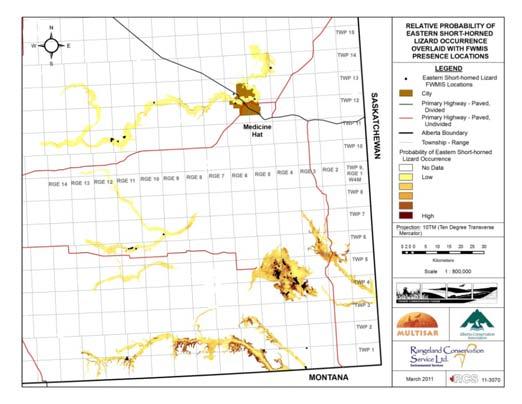
7
8 Resource selection functions (RSFs) are a conservation tool being utilized by MULTISAR as an alternative to Habitat Suitability Index (HSI) models. Where resources are defined as any abiotic or biotic factor directly used by an organism (Morrison 2002), a RSF is defined as a function (i.e., statistical model) that estimates the probability of use of a resource (Manly et al. 2002) RSF models are derived using empirical data as opposed to the expert opinion based HSI models
9 RSF model derived using location data for short-horned lizards contained within the Fish and Wildlife Management Information System (FWMIS) Model consisted of 11 variables: Distance to Badlands site type Distance to Loamy site type Distance to native upland Distance to riparian areas Distance to fluvial deposits Percent non-vegetation cover Percent grass cover Percent shrub cover Elevation Aspect (northness and eastness) * 7 Variables (in red type) were derived from the GVI dataset
10
11 Wildlife species select for very specific habitat features, which are not available in coarser datasets The Resource Selection Function model, using GVI, was better at predicting potential shorthorned lizard habitat than the original Habitat Suitability Index (HSI) model GVI dataset allowed for an increased number of variables in the model and a finer spatial resolution The RSF modeling approach improves the performance of models over the HSI approach and provides a better suite of tools to government and conservation organizations to help conserve species at risk
12 Manly, B.F., McDonald, L.L, D.L. Thomas, T.L. McDonald, and W.P. Erickson Resource Selection by Animals: Statistical Design and Analysis for Field Studies. Second Edition. Kluwer Academic Publishers. New York, NY. 221 pp. Morrison, M.L Wildlife Restoration: Techniques for habitat analysis and animal monitoring. Island Press. Washington, DC. 209 pp. U.S. Fish and Wildlife Service North Dakota's federally listed endangered, threatened, and candidate species 1995.
Puakea, Hawaiÿi. Puakea, Hawaiÿi WATERSHED FEATURES
 Puakea, Hawaiÿi DAR Watershed Code: 85046 Puakea, Hawaiÿi WATERSHED FEATURES Puakea watershed occurs on the island of Hawaiÿi. The Hawaiian meaning of the name is white blossom. The area of the watershed
Keanahalululu Gulch, Hawaiÿi
 DAR Watershed Code: 85021 WATERSHED FEATURES Keanahalululu Gulch watershed occurs on the island of Hawaiÿi. The Hawaiian meaning of the name is unknown. The area of the watershed is 4.1 square mi (10.6
Ecological Land Cover Classification For a Natural Resources Inventory in the Kansas City Region, USA
 Ecological Land Cover Classification For a Natural Resources Inventory in the Kansas City Region, USA by Applied Ecological Services, Inc. In cooperation with the Mid-America Regional Council 600 Broadway,
An Introduction to Day Two. Linking Conservation and Transportation Planning Lakewood, Colorado August 15-16, 16, 2006
 An Introduction to Day Two Linking Conservation and Transportation Planning Lakewood, Colorado August 15-16, 16, 2006 1 Agenda Day One Transportation Planning Heritage Program State Wildlife Action Plan
HABITAT EFFECTIVENESS AND SECURITY AREA ANALYSES
 HABITAT EFFECTIVENESS AND SECURITY AREA ANALYSES ESGBP 194 12. HABITAT EFFECTIVENESS AND SECURITY AREA ANALYSIS Michael Gibeau As demands on the land increase, cumulative effects result from individually
Case Study: Ecological Integrity of Grasslands in the Apache Highlands Ecoregion
 Standard 9: Screen all target/biodiversity element occurrences for viability or ecological integrity. Case Study: Ecological Integrity of Grasslands in the Apache Highlands Ecoregion Summarized from: Marshall,
Southwest LRT Habitat Analysis. May 2016 Southwest LRT Project Technical Report
 Southwest LRT Habitat Analysis Southwest LRT Project Technical Report This page intentionally blank. Executive Summary This technical report describes the habitat analysis that was performed to support
The Invasion of False Brome in Western Oregon
 The Invasion of False Brome in Western Oregon GIS II Presentation Winter 2006 Will Fellers Kurt Hellerman Kathy Strope Statia Cupit False Brome (Brachypodium sylvaticum) Perennial bunchgrass native to
GIS Data, Technology, and Models. to Integrate Information and Improve Transportation Decision-Making. within the Eco-Logical* Framework for Oregon
 GIS Data, Technology, and Models to Integrate Information and Improve Transportation Decision-Making within the Eco-Logical* Framework for Oregon GIS-T 2009, Oklahoma City, OK April 8, 2009, Session 5..2.2
To hear the seminar, dial (605) , access code
 , access code") Welcome to the Seminar Resource Selection Functions and Patch Occupancy Models: Similarities and Differences Lyman McDonald Senior Biometrician WEST, Inc. Cheyenne, Wyoming and Laramie, Wyoming lmcdonald@west-inc.com
Welcome to the Seminar Resource Selection Functions and Patch Occupancy Models: Similarities and Differences Lyman McDonald Senior Biometrician WEST, Inc. Cheyenne, Wyoming and Laramie, Wyoming lmcdonald@west-inc.com
The Use of GIS in Habitat Modeling
 Amy Gottfried NRS 509 The Use of GIS in Habitat Modeling In 1981, the U.S. Fish and Wildlife Service established a standard process for modeling wildlife habitats, the Habitat Suitability Index (HSI) and
Kootenai River Habitat Restoration Program Update
 Kootenai River Habitat Restoration Program Update Kootenai Tribe of Idaho Kootenai Valley Resource Initiative November 19, 2012 Bonners Ferry, Idaho Changes to Kootenai Basin Beaver trapping Floodplain
Wailupe, Oÿahu. Wailupe, Oÿahu WATERSHED FEATURES
 DAR Watershed Code: 33005 WATERSHED FEATURES Wailupe watershed occurs on the island of Oÿahu. The Hawaiian meaning of the name is kite water. The area of the watershed is 3.4 square mi (8.8 square km),
Wailua, Maui WATERSHED FEATURES
 Wailua, Maui DAR Watershed Code: 65007 Wailua, Maui WATERSHED FEATURES Wailua watershed occurs on the island of Maui. The Hawaiian meaning of the name is two waters. The area of the watershed is 1.9 square
HOUSEKEEPING. Notes. Upcoming meetings related to connectivity: FTP site? Zotero
 HOUSEKEEPING Notes Upcoming meetings related to connectivity: FTP site? Zotero NJ Land Conservation Rally March 9, 2013; NJIT in Newark, NJ One-day educational conference about preserving New Jersey s
UNIVERSITY OF CALGARY. Rare Plant Distribution Modelling: Exploring Predictor Datasets A Case Study in. Southeast Alberta. Laurie Hamilton A THESIS
 UNIVERSITY OF CALGARY Rare Plant Distribution Modelling: Exploring Predictor Datasets A Case Study in Southeast Alberta by Laurie Hamilton A THESIS SUBMITTED TO THE FACULTY OF GRADUATE STUDIES IN PARTIAL
Eva Strand CNR Remote Sensing and GIS Lab
 Eva Strand CNR Remote Sensing and GIS Lab Habitat map Available habitat Habitat Hectares Percent Habitat 1 38079.9 55.1 Habitat 2 2740.5 4.0 Habitat 3 2692.8 3.9 Habitat 4 24533.1 35.5 Habitat 5 1072.8
PROPOSED UNESCO FUNDY BIOSPHERE RESERVE
 OVERVIEW PROPOSED UNESCO FUNDY BIOSPHERE RESERVE NEW BRUNSWICK, CANADA NOMINATION DOCUMENT April 10, 2007 The United Nations Educational, Scientific and Cultural Organization (UNESCO) Man and the Biosphere
Appendix D ORV Assessment for Clarion River
 Introduction The following ORV assessment criteria were utilized in making WSR eligibility determinations for the 2007 ANF LRMP. These criteria will also be used to assess resource values for the Clarion
The Arctic Landscape Conservation Cooperative Conservation Goals
 The Arctic Landscape Conservation Cooperative Conservation Goals Adopted by the Arctic LCC Steering Committee, 24 August 2010 Background : Landscape Conservation Cooperatives and Climate Science Centers
SPRING GROVE AREA SCHOOL DISTRICT PLANNED INSTRUCTION. Course Title: Wildlife Studies Length of Course: 30 Cycles
 SPRING GROVE AREA SCHOOL DISTRICT PLANNED INSTRUCTION Course Title: Wildlife Studies Length of Course: 30 Cycles Grade Level(s): 12 Periods Per Cycle: 6 Units of Credit: 1 Length of Period: 43 Minutes
Partnering with LANDFIRE, NatureServe, and Heritage Programs. Utilizing Legacy Data for Ecological Site Concept Development and Descriptions
 Partnering with LANDFIRE, NatureServe, and Heritage Programs Utilizing Legacy Data for Ecological Site Concept Development and Descriptions Content LANDFIRE: BpS vs. EVT LANDFIRE: Disturbance Models NatureServe:
Assessing state-wide biodiversity in the Florida Gap analysis project
 University of Nebraska - Lincoln DigitalCommons@University of Nebraska - Lincoln Nebraska Cooperative Fish & Wildlife Research Unit -- Staff Publications Nebraska Cooperative Fish & Wildlife Research Unit
Appendix P San Joaquin Valley Greenprint
 Appendix P San Joaquin Valley Greenprint TCAG 2014 Regional Transportation Plan San Joaquin Valley Greenprint Data Supplement for SCS Planning And Impact Assessment 3/25/2013 This document is intended
MAUI. Introduction - Maui ISLAND OF MAUI
 ISLAND OF MAUI MAUI Located about 30 miles NNW of the Island of Hawaiÿi, Maui is the second youngest island in the Hawaiian Chain and roughly one-fifth the size (729 square miles) of the Big Island. It
Summary Description Municipality of Anchorage. Anchorage Coastal Resource Atlas Project
 Summary Description Municipality of Anchorage Anchorage Coastal Resource Atlas Project By: Thede Tobish, MOA Planner; and Charlie Barnwell, MOA GIS Manager Introduction Local governments often struggle
Changes in Texas Ecoregions
 Comment On Lesson Changes in Texas Ecoregions The state of Texas can be divided into 10 distinct areas based on unique combinations of vegetation, topography, landforms, wildlife, soil, rock, climate,
Using GIS to Focus Field Inventories of Rare and Endemic Plants at Badlands National Park, South Dakota
 Using GIS to Focus Field Inventories of Rare and Endemic Plants at Badlands National Park, South Dakota Sandee Dingman, Badlands National Park, P.O. Box 6, Interior, South Dakota 57750; sandee_dingman@nps.gov
Improvement of the National Hydrography Dataset for Parts of the Lower Colorado Region and Additional Areas of Importance to the DLCC
 Improvement of the National Hydrography Dataset for Parts of the Lower Colorado Region and Additional Areas of Importance to the DLCC Carlos Reyes-Andrade California State University, Northridge September
Landscape Planning and Habitat Metrics
 Landscape Planning and Habitat Metrics Frank W. Davis National Center for Ecological Analysis and Synthesis UC Santa Barbara (Tools for Landscape Biodiversity Planning) Jimmy Kagan Institute for Natural
Chapter 3. Description of the Study Area. Karl Taboga, James Stafford and Paul Taucher 3-19
 Chapter 3 Description of the Study Area Karl Taboga, James Stafford and Paul Taucher 3-19 T his study examines groundwater resources that underlie the Bear River drainage basin in Wyoming as well as areas
Grant Opportunity Monitoring Bi-State Sage-grouse Populations in Nevada
 Grant Opportunity Monitoring Bi-State Sage-grouse Populations in Nevada Proposals are due no later than November 13, 2015. Grant proposal and any questions should be directed to: Shawn Espinosa @ sepsinosa@ndow.org.
Chapter 6. Field Trip to Sandia Mountains.
 University of New Mexico Biology 310L Principles of Ecology Lab Manual Page -40 Chapter 6. Field Trip to Sandia Mountains. Outline of activities: 1. Travel to Sandia Mountains 2. Collect forest community
Remote Sensing Tools in Grasslands: Connection to the Larger Landscape?
 Remote Sensing Tools in Grasslands: Connection to the Larger Landscape? Anne Smith Agriculture and Agri-Food Canada Lethbridge Research and Development Centre Transboundary Grasslands Partnership Workshop
Introduction. Elevation Data Strategy. Status and Next Steps
 1 2 Introduction Elevation Data Strategy Status and Next Steps 3 Canada is the 2nd largest country in the world - 9.9 million sq km Surrounded by 3 oceans with 202 000 km of coastline Population over 35
Land Accounts - The Canadian Experience
 Land Accounts - The Canadian Experience Development of a Geospatial database to measure the effect of human activity on the environment Who is doing Land Accounts Statistics Canada (national) Component
Regional Sediment Management
 Regional Sediment Management Linda S. Lillycrop Program Manager Coastal Engineer US Army Engineer Research and Development Center Coastal and Hydraulics Laboratory Q AVG Coastal Resilience: The Environmental,
Bryan F.J. Manly and Andrew Merrill Western EcoSystems Technology Inc. Laramie and Cheyenne, Wyoming. Contents. 1. Introduction...
 Comments on Statistical Aspects of the U.S. Fish and Wildlife Service's Modeling Framework for the Proposed Revision of Critical Habitat for the Northern Spotted Owl. Bryan F.J. Manly and Andrew Merrill
Criteria for delineating a new boundary for the Fisher Bay Park Reserve, Manitoba
 1 Criteria for delineating a new boundary for the Fisher Bay Park Reserve, Manitoba R. A. Lastra Department of Botany, University of Manitoba, Winnipeg, MB, Canada, R3T 2N2 1. INTRODUCTION Historic park
Project Primary Contact: Gregg Servheen, Idaho Department of Fish and Game, PO Box 25 Boise, ID ,
 Project Title: Idaho Montana Divide Project Objective: Pilot the conceptualization and coordination of a transboundary Decision Support System(DSS) for fish, wildlife, and habitats along the Idaho Montana
Coastal Barrier Island Network (CBIN): Management strategies for the future
: Management strategies for the future") Coastal Barrier Island Network (CBIN): Management strategies for the future Heather Joesting*, Amy Williams**, Rusty Feagin**, and William K. Smith* *Department of Biology, Wake Forest University, Winston
Coastal Barrier Island Network (CBIN): Management strategies for the future Heather Joesting*, Amy Williams**, Rusty Feagin**, and William K. Smith* *Department of Biology, Wake Forest University, Winston
Wildlife A Map Colouring Book Map Colouring Books 2
 We have made it easy for you to find a PDF Ebooks without any digging. And by having access to our ebooks online or by storing it on your computer, you have convenient answers with wildlife a map colouring
Ecological Response Units Ecosystem Mapping System for the Southwest US
 Ecological Response Units Ecosystem Mapping System for the Southwest US J. C. Moreland, W. A. Robbie, F. J. Triepke, E. H. Muldavin, and J. R. Malusa Objectives What are Ecological Response Units? What
Land Use MTRI Documenting Land Use and Land Cover Conditions Synthesis Report
 Colin Brooks, Rick Powell, Laura Bourgeau-Chavez, and Dr. Robert Shuchman Michigan Tech Research Institute (MTRI) Project Introduction Transportation projects require detailed environmental information
A Regional Database Tracking Fire Footprint Each Year within the South Atlantic Region: Current Database Description and Future Directions
 A Regional Database Tracking Fire Footprint Each Year within the South Atlantic Region: Current Database Description and Future Directions Last Updated on September 30, 2018 Contributors: NatureServe,
Native species (Forbes and Graminoids) Less than 5% woody plant species. Inclusions of vernal pools. High plant diversity
 Less than 5% woody plant species. Inclusions of vernal pools. High plant diversity") WILLAMETTE VALLEY WET-PRAIRIE RESTORATION MODEL WHAT IS A WILLAMETTE VALLEY WET-PRAIRIE Hot Spot s Native species (Forbes and Graminoids) Rare plant species Less than 5% woody plant species Often dominated
WILLAMETTE VALLEY WET-PRAIRIE RESTORATION MODEL WHAT IS A WILLAMETTE VALLEY WET-PRAIRIE Hot Spot s Native species (Forbes and Graminoids) Rare plant species Less than 5% woody plant species Often dominated
Ecological mapping using satellite imagery: an Abu Dhabi case study Middle East Geospatial Forum 16 th February 2015
 Ecological mapping using satellite imagery: an Abu Dhabi case study Middle East Geospatial Forum 16 th February 2015 Richard Flemmings rf@proteusgeo.com About Proteus Formed in UAE 2011 We specialise in
Marl Prairie vegetation response to 20th century land use and its implications for management in the Everglades
 Marl Prairie vegetation response to 20th century land use and its implications for management in the Everglades C. Bernhardt, D. Willard, B. Landacre US Geological Survey Reston, VA USA U.S. Department
The Atlas Aspect of the Atlas of Living Australia
 The Atlas Aspect of the Atlas of Living Australia Lee Belbin lee@blatantfabrications.com Melbourne Museum, July 28, 2010 The Atlas is funded by the Australian Government under the National Collaborative
Keaÿahala, Oÿahu. Keaÿahala, Oÿahu WATERSHED FEATURES
 DAR Watershed Code: 32009 WATERSHED FEATURES Keaÿahala watershed occurs on the island of Oÿahu. The Hawaiian meaning of the name is the pandanas root. The area of the watershed is 1.6 square mi (4.2 square
SIF_7.1_v2. Indicator. Measurement. What should the measurement tell us?
 Indicator 7 Area of natural and semi-natural habitat Measurement 7.1 Area of natural and semi-natural habitat What should the measurement tell us? Natural habitats are considered the land and water areas
Environmental Response Management Application
 Environmental Response Management Application Coastal Response Research Center Nancy Kinner, Michele Jacobi, Rob Braswell, Kurt Schwehr & Amy Merten RRT III May 14, 2008 1 Talk Outline Overview of Center
United States Department of the Interior NATIONAL PARK SERVICE Northeast Region
 United States Department of the Interior NATIONAL PARK SERVICE Northeast Region June 17, 2017 REQUEST FOR STATEMENTS OF INTEREST and QUALIFICATIONS Project Title: ASSESSMENT OF NATURAL RESOURCE CONDITION
SEEA Experimental Ecosystem Accounting
 SEEA Experimental Ecosystem Accounting Sokol Vako United Nations Statistics Division Training for the worldwide implementation of the System of Environmental Economic Accounting 2012 - Central Framework
An Introduction to NatureServe Linking Conservation and Transportation Planning Phoenix, Arizona November 8 & 9, 2006
 An Introduction to NatureServe Linking Conservation and Transportation Planning Phoenix, Arizona November 8 & 9, 2006 1 NatureServe in Brief An independent, non-profit conservation organization Provides
Mapping on the Edge: shoreline mapping for regulation and voluntary stewardship
 Western Washington University Western CEDAR Salish Sea Ecosystem Conference 2016 Salish Sea Ecosystem Conference (Vancouver, BC) Mapping on the Edge: shoreline mapping for regulation and voluntary stewardship
Overview. Project Background Project Approach: Content and Application Development Application Demonstration Future Developments
 Overview Project Background Project Approach: Content and Application Development Application Demonstration Future Developments Southeast Pressures: Continued Population Growth Transportation Corridors
Name: Date: Class: Louisiana: Our History, Our Home Chapter 1: Louisiana s Geography - Section 2: Natural Regions Guided Reading
 Instructions: Read the section and complete each item with words from the passages in this section. 1. The diversity of Louisiana s can surprise residents and visitors alike. 2. Physical geography is concerned
Chapter 32. Australia & New Zealand
 Chapter 32 Australia & New Zealand Lesson 1: Physical Geography of Australia & New Zealand Landforms Australia lies between the Pacific and Indian Oceans in the Southern Hemisphere. Although an island,
Welcome to NetMap Portal Tutorial
 Welcome to NetMap Portal Tutorial Potential Applications What Can you do with the Portal? At least 25 things! 1) Locate the best potential fish habitats. 2) Identify biological hotspots. 3) Map floodplain
Shawn K. Staton Species at Risk Program Fisheries and Oceans Canada Burlington, Ontario
 Identification of Critical Habitat for Endangered Freshwater Mussels Shawn K. Staton Species at Risk Program Fisheries and Oceans Canada Burlington, Ontario Introduction Outline SARA & Critical Habitat
Part I History and ecological basis of species distribution modeling
 Part I History and ecological basis of species distribution modeling Recent decades have seen an explosion of interest in species distribution modeling. This has resulted from a confluence of the growing
Review of Riparian Function Riparian Management Riparian Monitoring
 Review of Riparian Function Riparian Management Riparian Monitoring Water Shed Water Catchment Water catching creek Water shedding creek Properly functioning riparian area Properly Functioning Riparian
Project Leader: Project Partners:
 UTILIZING LIDAR TO MAP HIGH PRIORITY WOODLAND HABITAT IN ARKANSAS DEVELOPING METHODOLOGY AND CONDUCTING A PILOT PROJECT IN THE OZARK HIGHLANDS TO MAP CURRENT EXTENT, SIZE AND CONDITION Project Summary
Developing a Landscape-Level Reference Standard Wetland Profile for the Prairie Pothole Region, Montana
 Developing a Landscape-Level Reference Standard Wetland Profile for the Prairie Pothole Region, Montana Prepared for: The U.S. Environmental Protection Agency Prepared by: Melissa Hart and Linda Vance
ESDs HELPING US BE MORE EFFICIENT. Leticia Lister Supervisory Rangeland Management Specialist BLM, Las Cruces District Office
 ESDs HELPING US BE MORE EFFICIENT Leticia Lister Supervisory Rangeland Management Specialist BLM, Las Cruces District Office 11/2010 Otero Mesa, L. Phillips, 9/2010 BLM, Las Cruces District Office SIERRA
Identifying Wildfire Risk Areas in Western Washington State
 Identifying Wildfire Risk Areas in Western Washington State Matthew Seto University of Washington Tacoma GIS Certification Program URISA 2015 Undergraduate Geospatial Skills Competition Introduction 2014
ADDRESSING GEOMORPHIC AND HYDRAULIC CONTROLS IN OFF-CHANNEL HABITAT DESIGN
 ADDRESSING GEOMORPHIC AND HYDRAULIC CONTROLS IN OFF-CHANNEL HABITAT DESIGN Conor Shea - Hydrologist U.S. Fish and Wildlife Service Conservation Partnerships Program Arcata, CA Learning Objectives Examine
Chapter 32. Australia & New Zealand
 Chapter 32 Australia & New Zealand Lesson 1: Physical Geography of Australia & New Zealand Landforms Australia lies between the Pacific and Indian Oceans in the Southern Hemisphere. Although an island,
GREATER SAGE-GROUSE HABITAT SUITABILITY ANALYSIS IN GRAND TETON NATIONAL PARK, WYOMING, USA Jean Edwards
 GREATER SAGE-GROUSE HABITAT SUITABILITY ANALYSIS IN GRAND TETON NATIONAL PARK, WYOMING, USA Jean Edwards INTRODUCTION AND PURPOSE The greater sage-grouse (Centrocercus urophasianus) is a large game bird
Soil Morphology and Stratigraphy on an Erosional Footslope: Dickinson Experiment Station in Western North Dakota
 Soil Morphology and Stratigraphy on an Erosional Footslope: Dickinson Experiment Station in Western North Dakota By D. Claypool, D. G. Hopkins, and J. L. Richardson ABSTRACT A first order soil survey of
An Update on Land Use & Land Cover Mapping in Ireland
 An Update on Land Use & Land Cover Mapping in Ireland Progress Towards a National Programme Kevin Lydon k.lydon@epa.ie Office of Environmental Assessment, Environmental Protection Agency, Johnstown Castle,
Classification of ecosystem types: Experiences and perspectives from Statistics Canada
 Classification of ecosystem types: Experiences and perspectives from Statistics Canada Jennie Wang, François Soulard, Mark Henry, Marcelle Grenier Environmental Accounts and Statistics Program Statistics
What is a watershed or landscape perspective?
 What is a watershed or landscape perspective? -remove sediment -add sediment -add wood, riparian manipulation -alter (engineer) channel/floodplain morphology -restore/abandon roads You are here What is
Getting Biodiversity Data
 Getting Biodiversity Data NatureServe Canada Douglas Hyde Executive Director Value of biodiversity data to business? Reasons vary depending on the business Reduce development uncertainty Integrated views
A national islands database and assessment of conservation value
 A national islands database and assessment of conservation value Julie Quinn and Karl Bossard Spotted-Tailed Quoll (D.Watts) Feral pig (B. Salau) Glossodia orchid (S.Bourne) Tracking and Tasman Island
Figure 1: Mapping occurrences on USGS topographic maps. Needs Figure 2: Comparison of buffered points and digitized occurrence boundaries
 Using Geographic Information Systems to Prepare Sensitive Species Information for Land Use Master Planning Ed Schools, Helen Enander, and John Paskus MSU Extension, Michigan Natural Features Inventory
Moanalua, Oÿahu. Moanalua, Oÿahu WATERSHED FEATURES
 DAR Watershed Code: 33012 WATERSHED FEATURES Moanalua watershed occurs on the island of Oÿahu. The Hawaiian meaning of the name is unknown. The area of the watershed is 10.5 square mi (27.2 square km),
Geospatial Data, Services, and Products. National Surveying, mapping and geospatial conference
 Geospatial Data, Services, and Products Federal Programs -- USDA NRCS National Surveying, mapping and geospatial conference March 15, 2016 NRCS Applications using Geosaptial Products & Services Field
FWS PROJECT Year project
 FWS PROJECT 2014 3 Year project Project Title: Core Habitat Identification and Fine Scale Habitat Use of Grizzly Bears in the US Northern Rockies and southern Canada Project Coordinator (contact information):
Eva Strand and Leona K. Svancara Landscape Dynamics Lab Idaho Coop. Fish and Wildlife Research Unit
 More on Habitat Models Eva Strand and Leona K. Svancara Landscape Dynamics Lab Idaho Coop. Fish and Wildlife Research Unit Area of occupancy Range - spatial limits within which a species can be found Distribution
Assessment. Assessment
 2001 SPRINGBROOK CREEK RESTORATION - THREE YEAR POST-CONSTRUCTION REVIEW - Presented by Bruce Henderson and Andy Harris 2005 River Restoration Northwest Symposium Skamania Lodge, Washington www.hendersonlandservices.com
EBA Engineering Consultants Ltd. Creating and Delivering Better Solutions
 EBA Engineering Consultants Ltd. Creating and Delivering Better Solutions ENHANCING THE CAPABILITY OF ECOSYSTEM MAPPING TO SUPPORT ADAPTIVE FOREST MANAGEMENT Prepared by: EBA ENGINEERING CONSULTANTS LTD.
Private Protected Areas Towards a comprehensive map for South Africa Alta De Vos* & Graeme Cumming
 Private Protected Areas Towards a comprehensive map for South Africa Alta De Vos* & Graeme Cumming alta.devos@gmail.com 2013 Biodiversity Planning Forum Golden Gate Highlands National Park May 2013 Spatial
RANGE AND ANIMAL SCIENCES AND RESOURCES MANAGEMENT - Vol. II - Catchment Management A Framework for Managing Rangelands - Hugh Milner
 CATCHMENT MANAGEMENT A FRAMEWORK FOR MANAGING RANGELANDS Hugh Milner International Water Management Consultant, Australia Keywords: Rangeland management; catchments and watersheds; catchment management
VEGETATION EVA BOEHRINGER
 VEGETATION EVA BOEHRINGER April 2, 2014 WUP CONSULTATIVE COMMITTEE WUP Consultative Committee (WUP CC) recognized that riparian and wetland vegetation in the reservoir drawdown zone is valuable for fish,
Groundwater Vulnerability Mapping Eastern Newfoundland Executive Summary
 Groundwater Vulnerability Mapping Eastern Newfoundland Executive Summary 123102.00 Executive Summary March 2014 ISO 9001 Registered Company Prepared for: Water Resources Management Division Department
RESEARCH METHODOLOGY
 III. RESEARCH METHODOLOGY 3.1. Time and Research Area The field work was taken place in primary forest around Toro village in Lore Lindu National Park, Indonesia. The study area located in 120 o 2 53 120
Steve Pye LA /22/16 Final Report: Determining regional locations of reference sites based on slope and soil type. Client: Sonoma Land Trust
 Steve Pye LA 221 04/22/16 Final Report: Determining regional locations of reference sites based on slope and soil type. Client: Sonoma Land Trust Deliverables: Results and working model that determine
Coastal Response Research Center. Nancy Kinner University of New Hampshire (UNH) Michele Jacobi NOAA ORR. September 27, 2007
 Michele Jacobi NOAA ORR. September 27, 2007") Coastal Response Research Center Nancy Kinner University of New Hampshire (UNH) Michele Jacobi NOAA ORR September 27, 2007 1 Coastal Response Research Center (CRRC) CRRC is partnership between NOAA s Office
Coastal Response Research Center Nancy Kinner University of New Hampshire (UNH) Michele Jacobi NOAA ORR September 27, 2007 1 Coastal Response Research Center (CRRC) CRRC is partnership between NOAA s Office
The Refugia Concept: Using Watershed Analysis to Prioritize Salmonid Habitat for Conservation and Restoration
 The Refugia Concept: Using Watershed Analysis to Prioritize Salmonid Habitat for Conservation and Restoration Christopher May Battelle & UW Cumulative Impacts of Urbanization Landscape Alterations Loss
Baseline Estuarine-Upland Transition Zone
 Baseline Estuarine-Upland Transition Zone in SF, San Pablo and Suisun Bays 10/5/18 Prepared for San Francisco Bay Joint Venture (SFBJV) Prepared by Brian Fulfrost, Principal bfaconsult@gmail.com with additional
FOURTEEN YEARS OF SPATIAL DATA FROM PLANTS OF CONCERN: WHAT ARE WE LEARNING?
 FOURTEEN YEARS OF SPATIAL DATA FROM PLANTS OF CONCERN: WHAT ARE WE LEARNING? Rachel Goad, Manager, Plants of Concern Shannon Still, Postdoctoral Researcher, Chicago Botanic Garden Jeremie Fant, Conservation
Geography Teach Yourself Series Topic 4: Global Distribution of Land Cover
 Geography Teach Yourself Series Topic 4: Global Distribution of Land Cover A: Level 14, 474 Flinders Street Melbourne VIC 3000 T: 1300 134 518 W: tssm.com.au E: info@tssm.com.au TSSM 2016 Page 1 of 7 Contents
Unmanned Aircraft Systems (UAS) Activities in Earth Sciences
 Activities in Earth Sciences") Unmanned Aircraft Systems (UAS) Activities in Earth Sciences Bruce K. Quirk quirk@usgs.gov Department of the Interior U.S. Geological Survey June 22, 2015 Department of the Interior Bureau of Land Management
Unmanned Aircraft Systems (UAS) Activities in Earth Sciences Bruce K. Quirk quirk@usgs.gov Department of the Interior U.S. Geological Survey June 22, 2015 Department of the Interior Bureau of Land Management
October 16, Remediation Technologies Symposium Banff, Alberta
 Using Collaborative Research and GIS Technology to Prove Natural Contaminants in the Alberta Oil Sands and in Alberta Grasslands Do Not Require Remediation October 16, 2013 2013 Remediation Technologies
BIODIVERSITY CONSERVATION HABITAT ANALYSIS
 BIODIVERSITY CONSERVATION HABITAT ANALYSIS A GIS Comparison of Greater Vancouver Regional Habitat Mapping with Township of Langley Local Habitat Mapping Preface This report was made possible through the
1:30 2:00 Tangible Examples of NVC Uses from Monitoring, Mapping, and Habitat Modeling. (Todd Keeler- Wolf, ESA Panel)
") 1:30 2:00 Tangible Examples of NVC Uses from Monitoring, Mapping, and Habitat Modeling. (Todd Keeler- Wolf, ESA Panel) Habitat Modeling for Mojave Ground Squirrel: a rare species of the Western Mojave
1:30 2:00 Tangible Examples of NVC Uses from Monitoring, Mapping, and Habitat Modeling. (Todd Keeler- Wolf, ESA Panel) Habitat Modeling for Mojave Ground Squirrel: a rare species of the Western Mojave
PAD-US (CBI Edition) Version 2: Standards and Procedures
 Version 2: Standards and Procedures") PAD-US (CBI Edition) Version 2: Standards and Procedures October 31, 2012 Prepared by: The Conservation Biology Institute Kai Henifin 1 Table of Contents INTRODUCTION TO PAD-US (CBI EDITION) VERSION 2...3
PAD-US (CBI Edition) Version 2: Standards and Procedures October 31, 2012 Prepared by: The Conservation Biology Institute Kai Henifin 1 Table of Contents INTRODUCTION TO PAD-US (CBI EDITION) VERSION 2...3
LOCAL KNOWLEDGE BASED MOOSE HABITAT SUITABILITY ASSESSMENT FOR THE SOUTH CANOL REGION, YUKON. Prepared by: Tess McLeod and Heather Clarke
 LOCAL KNOWLEDGE BASED MOOSE HABITAT SUITABILITY ASSESSMENT FOR THE SOUTH CANOL REGION, YUKON Prepared by: Tess McLeod and Heather Clarke September 2017 LOCAL KNOWLEDGE BASED MOOSE HABITAT SUITABILITY ASSESSMENT