MAUI. Introduction - Maui ISLAND OF MAUI
|
|
|
- Barrie Warren
- 6 years ago
- Views:
Transcription

1 ISLAND OF MAUI MAUI Located about 30 miles NNW of the Island of Hawaiÿi, Maui is the second youngest island in the Hawaiian Chain and roughly one-fifth the size (729 square miles) of the Big Island. It is formed from two shield volcanoes, the West Maui Mountains to the west and Haleakalā to the east. The highest point in West Maui is Puÿu Kukui at 5,788 feet. Haleakalā has a maximum elevation of just over 10,000 feet at Puÿu Ulaÿula. The two volcanoes are connected by a narrow isthmus about six miles across. Rainfall on the volcanoes is about inches annually on the windward slopes where streams are most common. Although habitats for aquatic animals living in fresh water have been reduced sharply by agricultural practices, scattered populations of indigenous stream animals (fishes, mollusks, and crustaceans) can be found in perennial and intermittent streams on the island. xli
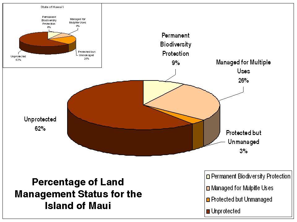
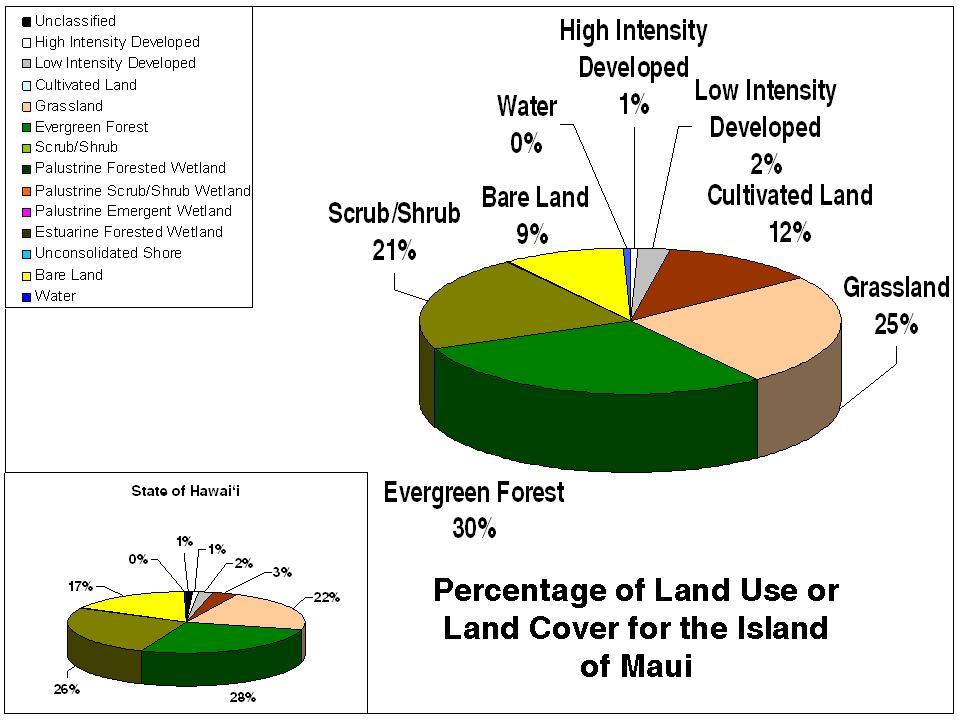
2 Maui has six regions (outlined in yellow) and 211 watersheds. The Atlas includes 98 watersheds. Of the 211 watersheds only 88 of them are considered to have a perennial stream by the USGS Digital Line Graphs, About 37.4 percent of the island s watersheds (highlighted in pink) and 66.0 percent of the island s perennial streams have been surveyed by the Division of Aquatic Resources, by the former Division of Fish and Game, by the United States Geological Survey (USGS), and during other nongovernmental surveys. In addition to surveys of aquatic macrofauna (fishes, crustaceans, and mollusks), damselfly surveys and museum insect collections are an important source of information for the island s streams. Well over half of the island is unprotected, a fraction is protected but unmanaged, and almost 10 percent receives permanent biodiversity protection. About one fourth of the land is managed for multiple purposes. Unprotected land on the island is close to the state average, protected but unmanaged land is much less than on other islands, and about the same percentage of land on Maui receives permanent protection as is average statewide. Management for multiple uses is about three times greater on the island than elsewhere. Land cover and use on Maui is mostly (76 percent) scrub/shrub, evergreen forest, and grassland and approximates the statewide occurrence of these vegetation types. There is appreciably more cultivated land, less bare land, and about the same high and low intensity developed land as among other islands. xlii
3 xliii
.")
4 Land Use Districts are mostly conservation and agriculture in amounts that nearly match the statewide occurrence of these activities. Urban use coincides with the percentage among all the islands, and rural use is slightly higher (1 percent vs. 0 percent). Stewardship of the land on Maui is mostly private and by the State (87 percent when combined), with private land somewhat higher than the state average and State ownership slightly lower. More land is afforded to Hawaiian Homestead than the statewide average. Federal land is similar to the percentages throughout the islands. Little military stewardship of the land on Maui exists although this category includes about four percent of the land statewide. xliv

5 References: Juvik, S. P. & J. O. Juvik, Atlas of Hawaiÿi, 3 rd edition, University of Hawaii Press, Honolulu. 333 pp. Parham, J. E Spatial models of Hawaiian streams and stream fish habitats. Ph.D. Dissertation, Louisiana State University, 149 pp. xlv
6 Blank Page xlvi
Keanahalululu Gulch, Hawaiÿi
 DAR Watershed Code: 85021 WATERSHED FEATURES Keanahalululu Gulch watershed occurs on the island of Hawaiÿi. The Hawaiian meaning of the name is unknown. The area of the watershed is 4.1 square mi (10.6
Puakea, Hawaiÿi. Puakea, Hawaiÿi WATERSHED FEATURES
 Puakea, Hawaiÿi DAR Watershed Code: 85046 Puakea, Hawaiÿi WATERSHED FEATURES Puakea watershed occurs on the island of Hawaiÿi. The Hawaiian meaning of the name is white blossom. The area of the watershed
Wailupe, Oÿahu. Wailupe, Oÿahu WATERSHED FEATURES
 DAR Watershed Code: 33005 WATERSHED FEATURES Wailupe watershed occurs on the island of Oÿahu. The Hawaiian meaning of the name is kite water. The area of the watershed is 3.4 square mi (8.8 square km),
Wailua, Maui WATERSHED FEATURES
 Wailua, Maui DAR Watershed Code: 65007 Wailua, Maui WATERSHED FEATURES Wailua watershed occurs on the island of Maui. The Hawaiian meaning of the name is two waters. The area of the watershed is 1.9 square
Moanalua, Oÿahu. Moanalua, Oÿahu WATERSHED FEATURES
 DAR Watershed Code: 33012 WATERSHED FEATURES Moanalua watershed occurs on the island of Oÿahu. The Hawaiian meaning of the name is unknown. The area of the watershed is 10.5 square mi (27.2 square km),
Keaÿahala, Oÿahu. Keaÿahala, Oÿahu WATERSHED FEATURES
 DAR Watershed Code: 32009 WATERSHED FEATURES Keaÿahala watershed occurs on the island of Oÿahu. The Hawaiian meaning of the name is the pandanas root. The area of the watershed is 1.6 square mi (4.2 square
Utility of National Spatial Data for Conservation Design Projects
 Utility of National Spatial Data for Conservation Design Projects Steve Williams Biodiversity and Spatial Information Center North Carolina State University PIF CDW St. Louis, MO April 11, 2006 Types of
ISOLINE MAPS and RAINFALL
 ISOLINE MAPS and RAINFALL Geography 101 Lab Name Purpose: Introduce students to one of the most common and useful types of maps used in studying the natural environment. When completed, the student should
Oliver Elison Timm 1, Thomas W. Giambelluca 2, and Henry F. Diaz 3. Albany, Albany, New York, USA, Colorado Boulder, Boulder, Colorado, USA
 Corrections to the article Statistical downscaling of rainfall changes in Hawai i based on the CMIP5 global model projections published (online) in JGR-Atmospheres 12 JAN 2015 Oliver Elison Timm 1, Thomas
THE MINISTRY OF ENERGY AND ENERGY INDUSTRIES MINERALS DIVISION MINE DESIGN TEMPLATE OPERATOR NAME: OPERATOR ADDRESS: PHONE NUMBER: FACSIMILE:
 THE MINISTRY OF ENERGY AND ENERGY INDUSTRIES MINERALS DIVISION MINE DESIGN TEMPLATE 1.0 GENERAL INFORMATION OPERATOR NAME: OPERATOR ADDRESS: PHONE NUMBER: FACSIMILE: NAME OF CONTACT: CELLULAR PHONE: EMAIL
Earth s Major Terrerstrial Biomes. *Wetlands (found all over Earth)
") Biomes Biome: the major types of terrestrial ecosystems determined primarily by climate 2 main factors: Depends on ; proximity to ocean; and air and ocean circulation patterns Similar traits of plants
Biomes Biome: the major types of terrestrial ecosystems determined primarily by climate 2 main factors: Depends on ; proximity to ocean; and air and ocean circulation patterns Similar traits of plants
Integrating Aquatic Insect Data Into Hawaiian Stream Assessments
 Integrating Aquatic Insect Data Into Hawaiian Stream Assessments DAN A. POLHEMUS Division of Aquatic Resources DLNR State of Hawaii Insects for the Future HAWAII Hawaiian Islands is an isolated hotspot
South Florida Coastal Storm Surge and Mapping Study
 South Florida Coastal Storm Surge and Mapping Study Presented by Christopher Bender, Ph.D., P.E., D.CE June 2, 2015 Presentation Overview FEMA risk studies outline Overview South Florida surge study Work
Chapter 3. Description of the Study Area. Karl Taboga, James Stafford and Paul Taucher 3-19
 Chapter 3 Description of the Study Area Karl Taboga, James Stafford and Paul Taucher 3-19 T his study examines groundwater resources that underlie the Bear River drainage basin in Wyoming as well as areas
Biosphere Biome Ecosystem Community Population Organism
 Ecology ecology - The study of living things and how they relate to their environment Levels of Organization in Ecology organism lowest level one living thing population collection of organisms of the
Ecoregional Assessment of Biodiversity Conservation Executive Summary September 2006 Hawaiian High Islands
 Ecoregional Assessment of Biodiversity Conservation Executive Summary September 2006 Hawaiian High Islands This executive summary presents an 9-page overview of the Hawaiian High Islands Ecoregional Assessment
NC Streambed Mapping Project Issue Paper
 ISSUE 1: The Western North Carolina Drainage Area Requirement Issue Several inquiries and discussions in regard to the determination of the 6-acre drainage area requirement as the upstream limit have been
POPULATION TRENDS FOR TULARE PSEUDOBAHIA AND STRIPED ADOBE LILY
 POPULATION TRENDS FOR TULARE PSEUDOBAHIA AND STRIPED ADOBE LILY Kern County has more endangered, threatened and rare plant species than most states. The geography and environmental conditions in the county
Most people used to live like this
 Urbanization Most people used to live like this Increasingly people live like this. For the first time in history, there are now more urban residents than rural residents. Land Cover & Land Use Land cover
Geography 415 Hydrology
 1 Geography 415 Hydrology LAB 1 (January 23, 2003) TA: Drew Lejbak Office: ES 310, 220-5590, atlejbak@ucalgary.ca Hours: Friday 10:00am 12:00pm, or by appointment Drop Box: Outside ES 313 1. Estimation
Climatic Change Implications for Hydrologic Systems in the Sierra Nevada
 Climatic Change Implications for Hydrologic Systems in the Sierra Nevada Part Two: The HSPF Model: Basis For Watershed Yield Calculator Part two presents an an overview of why the hydrologic yield calculator
CHAPTER 12: TERRESTRIAL LAYERS
 CHAPTER 12: TERRESTRIAL LAYERS Coordinator: Shannon McElvaney Hawai`i Natural Heritage Program mcelvane@hawaii.edu Theme Description: Land use corresponds to the socio-economic description (or functional
Information Paper. Kansas City District. Missouri River Fish and Wildlife Mitigation Project Jim and Olivia Hare Wildlife Area, MO
 City District Information Paper River Fish and Wildlife Mitigation Project Jim and Olivia Hare Wildlife Area, MO Riverine habitat created in 2004/2005 by modifying existing river structures along the banks,
5/4/2017 Fountain Creek. Gage Analysis. Homework 6. Clifton, Cundiff, Pour, Queen, and Zey CIVE 717
 5/4/2017 Fountain Creek Gage Analysis Homework 6 Clifton, Cundiff, Pour, Queen, and Zey CIVE 717 Introduction: The CIVE 717 class members, Nate Clifton, Susan Cundiff, Ali Reza Nowrooz Pour, Robbie Queen
Chapter 7 Part III: Biomes
 Chapter 7 Part III: Biomes Biomes Biome: the major types of terrestrial ecosystems determined primarily by climate 2 main factors: Temperature and precipitation Depends on latitude or altitude; proximity
Summary Description Municipality of Anchorage. Anchorage Coastal Resource Atlas Project
 Summary Description Municipality of Anchorage Anchorage Coastal Resource Atlas Project By: Thede Tobish, MOA Planner; and Charlie Barnwell, MOA GIS Manager Introduction Local governments often struggle
Ecological Land Cover Classification For a Natural Resources Inventory in the Kansas City Region, USA
 Ecological Land Cover Classification For a Natural Resources Inventory in the Kansas City Region, USA by Applied Ecological Services, Inc. In cooperation with the Mid-America Regional Council 600 Broadway,
Classification of Erosion Susceptibility
 GEO327G: GIS & GPS Applications in Earth Sciences Classification of Erosion Susceptibility Denali National Park, Alaska Zehao Xue 12 3 2015 2 TABLE OF CONTENTS 1 Abstract... 3 2 Introduction... 3 2.1 Universal
OS 1 The Oceans Fall 2007
 Name: Plate Tectonics (you must turn Activities 1-2 in during Section) Activity 1: Plate Boundaries A plate boundary simply describes where two plates (either oceanic or continental material) meet. There
Alaska, USA. Sam Robbins
 Using ArcGIS to determine erosion susceptibility within Denali National Park, Alaska, USA Sam Robbins Introduction Denali National Park is six million acres of wild land with only one road and one road
Exercise 6: Working with Raster Data in ArcGIS 9.3
 Exercise 6: Working with Raster Data in ArcGIS 9.3 Why Spatial Analyst? Grid query Grid algebra Grid statistics Summary by zone Proximity mapping Reclassification Histograms Surface analysis Slope, aspect,
Savannah District s Revised SOP: Moving Towards A Functional Approach. US Army Corps of Engineers BUILDING STRONG
 Savannah District s Revised SOP: Moving Towards A Functional Approach US Army Corps of Engineers Agenda SOP Revision Concept New Aquatic Resource Credit Types New Urban Mitigation Service Area Filter Background
8 th 12 th Designing a Monitoring Plan Mapping & Analysis (Activities 1 2)
") 8 th 12 th Designing a Monitoring Plan Mapping & Analysis (Activities 1 2) Objectives for All Activities - To be able to define and describe the purpose and uses of topographic maps. - To define rules
8 th 12 th Designing a Monitoring Plan Mapping & Analysis (Activities 1 2) Objectives for All Activities - To be able to define and describe the purpose and uses of topographic maps. - To define rules
Suggested volcano pattern in relation to the earthquake pattern and topography Learning Segment 7.1
 Teacher questions to prompt student observations of patterns : Describe the earthquake pattern. (Learning Segment 5.6) Describe the volcano pattern. (Learning Segment 6.5) Describe the volcano pattern
Laboratory Exercise #2 Introduction to Quadrangle Maps
 page - 1 Laboratory Exercise #2 Introduction to Quadrangle Maps A. Introduction to Quadrangle Maps The United States Geological Survey has developed a nationwide series of quadrangle maps that cover small
Using Grassland Vegetation Inventory Data
 Adam Moltzahn Eastern Short-Horned Lizard Using Grassland Vegetation Inventory Data The GVI represents the Government of Alberta s comprehensive biophysical, anthropogenic and land-use inventory of the
Biomes There are 2 types: Terrestrial Biomes (on land) Aquatic Biomes (in the water)
 Aquatic Biomes (in the water)") Biomes There are 2 types: Terrestrial Biomes (on land) Aquatic Biomes (in the water) Terrestrial Biomes Grassland, Desert, and Tundra Biomes: Savanna Temperate grassland Chaparral Desert Tundra Chapter
Biomes There are 2 types: Terrestrial Biomes (on land) Aquatic Biomes (in the water) Terrestrial Biomes Grassland, Desert, and Tundra Biomes: Savanna Temperate grassland Chaparral Desert Tundra Chapter
Effects of input DEM data spatial resolution on Upstream Flood modeling result A case study in Willamette river downtown Portland
 Effects of input DEM data spatial resolution on Upstream Flood modeling result A case study in Willamette river downtown Portland By Hue Duong GEOG 593 Fall 2015 Digital Terrain Analysis Photo: Anh Duc
Climates of NYS. Definitions. Climate Regions of NYS. Storm Tracks. Climate Controls 10/13/2011. Characteristics of NYS s Climates
 Definitions Climates of NYS Prof. Anthony Grande 2011 Weather and Climate Weather the state of the atmosphere at one point in time. The elements of weather are temperature, air pressure, wind and moisture.
Tropical Montane Cloud Forests: Importance and Challenges in a Changing Environment
 Tropical Montane Cloud Forests: Importance and Challenges in a Changing Environment Daniel E. Comarazamy and Jorge E. González The NOAA-CREST Center & Department of Mechanical Engineering, City College
Development of Improved Stream Mapping for NC
 Development of Improved Stream Mapping for NC Presentation for Soil Science Society of North Carolina NC Division of Water Quality January 21, 2009 What are stream maps used for? Riparian buffer rules
 Red River Flooding June 2015 Caddo and Bossier Parishes Presented by: Flood Technical Committee Where the Rain Falls Matters I-30 versus I-20 I-20 Backwater and Tributary Floods (Localized) 2016 Flood
Chapter 32. Australia & New Zealand
 Chapter 32 Australia & New Zealand Lesson 1: Physical Geography of Australia & New Zealand Landforms Australia lies between the Pacific and Indian Oceans in the Southern Hemisphere. Although an island,
Chapter 3 - White Oak River Subbasin Includes Bogue Sound and the Newport River
 Chapter 3 - White Oak River Subbasin 03-05-03 Includes Bogue Sound and the Newport River 3.1 Water Quality Overview Subbasin 03-05-03 at a Glance Land and Water Area (sq. mi.) Total area: 228 Land area:
Section B - Chapter 13 Neuse River Subbasin Bay River and Pamlico Sound
 Section B - Chapter 13 Neuse River Subbasin 3-4-13 Bay River and Pamlico Sound 13.1 Subbasin Overview Subbasin 3-4-13 at a Glance Land and Water Area Total area: 277 mi 2 Land area: 145 mi 2 Water area:
LANDSLIDE HAZARD ANALYSIS AND ITS EFFECT ON ENDANGERED SPECIES HABITATS, GRAND COUNTY, UTAH
 12/5/2016 LANDSLIDE HAZARD ANALYSIS AND ITS EFFECT ON ENDANGERED SPECIES HABITATS, GRAND COUNTY, UTAH GIS Final Project Ashlyn Murphy Fall 2016 1. Introduction and Problem A well-known geologic hazard
The Atmosphere and Atmospheric Energy Chapter 3 and 4
 The Atmosphere and Atmospheric Energy Chapter 3 and 4 Size of the Earth s Atmosphere Atmosphere produced over 4.6 billion years of development Protects us from radiation Completely surrounds the earth
Description DESCRIPTION
 DESCRIPTION The location of the Upper James Watershed is located in northeastern South Dakota as well as southeastern North Dakota. It includes the following counties located in North Dakota Barnes, Dickey,
Southwest LRT Habitat Analysis. May 2016 Southwest LRT Project Technical Report
 Southwest LRT Habitat Analysis Southwest LRT Project Technical Report This page intentionally blank. Executive Summary This technical report describes the habitat analysis that was performed to support
Adaptive Radiations. Hawaiian archipelago - the example for adaptive radiations. for adaptive radiations. for adaptive radiations
 Adaptive Radiations We will examine adaptive radiations in the context of the Hawaiian Islands Hawaiian archipelago - the example for adaptive radiations Getting there is half the problem...but then they
Regional Atlas Activity C
 Political Location Activity AUSTRALIA, OCEANIA, AND ANTARCTICA Regional Atlas Activity C DIRECTIONS: Identify each country marked by a number on the map. Then write the correct name on the numbered blanks
Streams in the Ranching Country of South Texas
 Streams in the Ranching Country of South Texas Watershed Analysis of HUC 12110207 Sandranell Moerbe CE GIS in Water Resources Fall 2015 INTRODUCTION This project investigates the portion of South Texas
Chapter 32. Australia & New Zealand
 Chapter 32 Australia & New Zealand Lesson 1: Physical Geography of Australia & New Zealand Landforms Australia lies between the Pacific and Indian Oceans in the Southern Hemisphere. Although an island,
Pedodiversity and Island Soil Geography: Testing the Driving Forces for Pedological Assemblages in Archipelagos of Different Origins
 Pedodiversity and Island Soil Geography: Testing the Driving Forces for Pedological Assemblages in Archipelagos of Different Origins William R. Effland, Ph.D. Soil Survey Division, USDA/NRCS A. Rodriguez-Rodriguez,
Moreton Bay and Key Geographic Concepts Worksheet
 Moreton Bay and Key Geographic Concepts Worksheet The Australian Curriculum: Geography draws on seven key geographic concepts: place scale space environment change interconnection sustainability They are
Geography Unit Grade 4
 ÿöhiÿa Project Exploring the Islands Geography Unit Grade 4 HCPS Content Standards/Benchmarks Physical Systems Explain how physical processes affect formation and distribution of climates, natural resources
Module 4: Overview of the Fundamentals of Runoff and Erosion
 Module 4: Overview of the Fundamentals of Runoff and Erosion Module 4a Goal Once we can better understand the forces which cause erosion and runoff, only then can we begin to minimize the negative results.
NOAA National Centers for Environmental Information State Summaries 149-HI. Observed and Projected Temperature Change
 9-HI HAWAI I Key Messages Average annual temperature has increased by about F since 95, with a leveling off of the rate of warming in the last two decades. Under a higher emissions pathway, historically
Archaeological Assessment for the Proposed Verizon H13 Volcano Winery Cell Site, Volcano, Hawaii Island TMK:(3) :035
 :035") T. S. Dye & Colleagues, Archaeologists, Inc. 735 Bishop St., Suite 315, Honolulu, Hawai i 96813 Archaeological Assessment for the Proposed Verizon H13 Volcano Winery Cell Site, Volcano, Hawaii Island TMK:(3)9
T. S. Dye & Colleagues, Archaeologists, Inc. 735 Bishop St., Suite 315, Honolulu, Hawai i 96813 Archaeological Assessment for the Proposed Verizon H13 Volcano Winery Cell Site, Volcano, Hawaii Island TMK:(3)9
The United States & Canada. A Regional Study of Anglo America
 A Regional Study of Anglo America Landform Regions of the United States & Canada world leaders in agricultural and industrial production because of... VAST LANDS stretch from the Atlantic Ocean on the
Natural Texas. Regions and Climates
 Natural Texas Regions and Climates Two Kinds: Physical geography Climate, vegetation, rivers, lakes, oceans, plateaus, plains, and mountain ranges Human geography Economic activities How we earn a living
Hillslope Erosion Rates in the Oak Savannas of the Southwestern Borderlands Region
 Hillslope Erosion Rates in the Oak Savannas of the Southwestern Borderlands Region Item type Authors Publisher Journal Rights text; Proceedings Kauffman, Arron T.; Stropki, Cody L.; Ffolliott, Peter F.;
MISSOURI LiDAR Stakeholders Meeting
 MISSOURI LiDAR Stakeholders Meeting East-West Gateway June 18, 2010 Tim Haithcoat Missouri GIO Enhanced Elevation Data What s different about it? Business requirements are changing.fast New data collection
Big Wood River. General Information
 General Information The flows out of the southern portion of the Sawtooth National Recreation Area in central Idaho. The study reach is about a,200 ft length of river about.5 miles upstream from the discontinued
Environmental Science
 Environmental Science A Study of Interrelationships Cui Jiansheng Hebei University of Science and Technology CH06 Kinds of Ecosystems and Communities Chapter Objectives After reading this chapter, you
Improvement of the National Hydrography Dataset for US Forest Service Region 3 in Cooperation with the National Forest Service
 Improvement of the National Hydrography Dataset for US Forest Service Region 3 in Cooperation with the National Forest Service Christian L. DeCasas California State University, Northridge November 7 th,
Monitoring Hurricane Rita Inland Storm Surge
 Monitoring Hurricane Rita Inland Storm Surge By Benton D. McGee, Roland W. Tollett, and Burl B. Goree Pressure transducers (sensors) are accurate, reliable, and cost-effective tools to measure and record
How does the physical environment influence communities and ecosystems? Hoodoos in Cappadocia, Turkey
 Biomes of the World How does the physical environment influence communities and ecosystems? Hoodoos in Cappadocia, Turkey ecosystems are shaped by: abiotic factors climate/weather space Rainfall Soil air
2. PHYSICAL SETTING FINAL GROUNDWATER MANAGEMENT PLAN. 2.1 Topography. 2.2 Climate
 FINAL GROUNDWATER MANAGEMENT PLAN 2. PHYSICAL SETTING Lassen County is a topographically diverse area at the confluence of the Cascade Range, Modoc Plateau, Sierra Nevada and Basin and Range geologic provinces.
Unit V Volcanoes. Q-2 Use the scale bar to determine approximately how wide (in miles) Mt. Shasta is at is widest point. miles
 Mt. Shasta is at is widest point. miles") Unit V Volcanoes Name: California Geology Questions 1-9 Figure 1 is a shaded relief map from the USGS showing the area surrounding Mt. Shasta. Mt. Shasta itself is in the center of the map. Note that there
Unit V Volcanoes Name: California Geology Questions 1-9 Figure 1 is a shaded relief map from the USGS showing the area surrounding Mt. Shasta. Mt. Shasta itself is in the center of the map. Note that there
PART 1: E_Subsidence
 PART 1: E_Subsidence At the end of the activity, each group member will turn in: 1. Three maps with paleoshorelines indicated and a completed table of Subsidence for Hawaiian Ridge Volcanoes. 2. One graph
Great California Delta Trail Blueprint for Contra Costa and Solano Counties GIS AND MAPPING MEMORANDUM JULY 2010
 Great California Delta Trail Blueprint for Contra Costa and Solano Counties GIS AND MAPPING MEMORANDUM JULY 2010 {DRAFT} July 2010 Introduction Geographic Information Systems (GIS) are computer-based
Land Use Methods & Metrics Development Outcome
 Quarterly Progress Meeting November 15, 2018 Land Use Methods & Metrics Development Outcome Peter Claggett, USGS LUWG Coordinator Through the Chesapeake Bay Watershed Agreement, the Chesapeake Bay Program
Sec$on 1: Geography and Early China. How does China s geography affect the culture?
 Sec$on 1: Geography and Early China How does China s geography affect the culture? Con$nents of the World Label the continents. Where is China located? Where is China located? In your groups, begin filling
2012 Rainfall, Runoff, Water Level & Temperature Beebe Lake Wright County, MN (# )
") www.fixmylake.com 18029 83 rd Avenue North Maple Grove, MN 55311 mail@freshwatersci.com (651) 336-8696 2012 Rainfall, Runoff, Water Level & Temperature Beebe Lake Wright County, MN (#86-0023) Prepared
www.fixmylake.com 18029 83 rd Avenue North Maple Grove, MN 55311 mail@freshwatersci.com (651) 336-8696 2012 Rainfall, Runoff, Water Level & Temperature Beebe Lake Wright County, MN (#86-0023) Prepared
Unit 1: Geography GeoTrekkers in the Western Hemisphere. Illustrated Glossary
 Unit 1: Geography GeoTrekkers in the Western Hemisphere Illustrated Glossary adapt to change in order to fit new condi/ons archipelago a group or chain of islands clustered together in a sea or ocean bodies
Illinois Drought Update, December 1, 2005 DROUGHT RESPONSE TASK FORCE Illinois State Water Survey, Department of Natural Resources
 Illinois Drought Update, December 1, 2005 DROUGHT RESPONSE TASK FORCE Illinois State Water Survey, Department of Natural Resources For more drought information please go to http://www.sws.uiuc.edu/. SUMMARY.
Laboratory Exercise #2 Introduction to Quadrangle Maps
 page - Laboratory Exercise #2 Introduction to Quadrangle Maps A. Introduction to Quadrangle Maps The United States Geological Survey has developed a nationwide series of quadrangle maps that cover small
Appendix E Guidance for Shallow Flooding Analyses and Mapping
 Appendix E Guidance for Shallow Flooding Analyses and Mapping E.1 Introduction Different types of shallow flooding commonly occur throughout the United States. Types of flows that result in shallow flooding
Board of Regents' CIP Budget
 Board of Regents' CIP Budget 1 Health, Safety, and Code Requirements UOH 900 Plans 153 1 C 1 C 1 C Design 4,806 1,490 C 145 C 1,490 C 145 C 1,490 C Construction 51,126 16,442 C 965 C 16,442 C 965 C 16,442
Cambridge International Examinations Cambridge Ordinary Level
 Cambridge International Examinations Cambridge Ordinary Level *5500826079* ENVIRONMENTAL MANAGEMENT 5014/12 Paper 1 May/June 2016 2 hours 15 minutes Candidates answer on the Question Paper. No Additional
NAVAJO NATION PROFILE
 NAVAJO NATION PROFILE Largest land based area and federally recognized tribe in the United States Over 27,000 square miles (or 17.2 million acres with a population of over 300,000 people. Covers Arizona,
Hurricane Lane. Hawaiian Islands, August By Ian Robertson 1, Ph.D., P.E.
 Hurricane Lane Hawaiian Islands, August 2018 By Ian Robertson 1, Ph.D., P.E. Hurricane Lane, a major Pacific Ocean hurricane, narrowly missed making landfall on the main Hawaiian Islands, but still caused
Roger Andy Gaines, Research Civil Engineer, PhD, P.E.
 Roger Andy Gaines, Research Civil Engineer, PhD, P.E. Research Civil Engineer/Regional Technical Specialist Memphis District August 24, 2010 Objectives Where we have been (recap of situation and what s
Red River Levee Panel
 Red River Levee Panel Mississippi River Commission Monday, August 9, 2017 Red River Levees in LA & AR NONE along TX & OK Boarder Red River Levee Issues Caddo Levee Cherokee Park Authorization Bossier Levee
The Point Quadrat Method: a Rapid Assessment of Hawaiian Streams
 Biology of Hawaiian Streams and Estuaries. Edited by N.L. Evenhuis & J.M. Fitzsimons. Bishop Museum Bulletin in Cultural and Environmental Studies 3: 305 312 (2007). 305 The Point Quadrat Method: a Rapid
CLIMATE READY BOSTON. Climate Projections Consensus ADAPTED FROM THE BOSTON RESEARCH ADVISORY GROUP REPORT MAY 2016
 CLIMATE READY BOSTON Sasaki Steering Committee Meeting, March 28 nd, 2016 Climate Projections Consensus ADAPTED FROM THE BOSTON RESEARCH ADVISORY GROUP REPORT MAY 2016 WHAT S IN STORE FOR BOSTON S CLIMATE?
SPATIAL AND TEMPORAL ANALYSIS OF THE DEGRADATION OF NATURAL RESOURCES IN RIVER LIKODRA WATERSHED
 Soil Erosion Modelling JRC Ispra 20-21-22 March 2017 University of Belgrade, Faculty of Forestry Department for Ecological Engineering in Protection of Soil and Water Resources SPATIAL AND TEMPORAL ANALYSIS
Physical Geography of the United States and Canada Chapter 5 A Land of Contrasts
 Physical Geography of the United States and Canada Chapter 5 A Land of Contrasts Land Area Together the U.S. and Canada cover more than 7 million square miles. In total area, Canada ranks 2 nd and the
Development of statewide 30 meter winter sage grouse habitat models for Utah
 Development of statewide 30 meter winter sage grouse habitat models for Utah Ben Crabb, Remote Sensing and Geographic Information System Laboratory, Department of Wildland Resources, Utah State University
Alamito Creek Preserve Ranches for Sale Marfa, Presidio County, Texas
 Alamito Creek Preserve Ranches for Sale Marfa, Presidio County, Texas James King, Agent Office 432 426.2024 Cell 432 386.2821 James@KingLandWater.com Alamito Creek Preserve Various size Ranch Properties,
Preliminary Calculation of Landscape Integrity in West Virginia Based on Distance from Weighted Disturbances
 Preliminary Calculation of Landscape Integrity in West Virginia Based on Distance from Weighted Disturbances Michael Dougherty and Elizabeth Byers Technical Support and Wildlife Diversity Units, Wildlife
Hannah Moore CEE Juvenile Bull Trout Distribution in the South Fork Walla Walla River, Oregon
 Hannah Moore CEE 6440 Juvenile Bull Trout Distribution in the South Fork Walla Walla River, Oregon Introduction Bull trout (Salvelinus confluentus) are an endangered species historically found throughout
TSEGI WASH 50% DESIGN REPORT
 TSEGI WASH 50% DESIGN REPORT 2/28/2014 Daniel Larson, Leticia Delgado, Jessica Carnes I Table of Contents Acknowledgements... IV 1.0 Project Description... 1 1.1 Purpose... 1 Figure 1. Erosion of a Headcut...
MiSP Plate Tectonics Worksheet #2 L3
 MiSP Plate Tectonics Worksheet #2 L3 Name Date THE HAWAIIAN ISLANDS TECTONIC PLATE MOVEMENT Introduction: (excerpts from Wikipedia and http://pubs.usgs.gov/publications/text/hawaiian.html) The Hawaiian
Assessing Spatial and Temporal Distribution of Sediment, Nitrogen and Phosphorous Loading in the Missouri River Basin (MORB)
") Assessing Spatial and Temporal Distribution of Sediment, Nitrogen and Phosphorous Loading in the Missouri River Basin (MORB) Zhonglong Zhang, PhD, PE, May Wu, PhD LimnoTech, Environmental Laboratory, ERDC,
Assessing Spatial and Temporal Distribution of Sediment, Nitrogen and Phosphorous Loading in the Missouri River Basin (MORB) Zhonglong Zhang, PhD, PE, May Wu, PhD LimnoTech, Environmental Laboratory, ERDC,
Section 4: Model Development and Application
 Section 4: Model Development and Application The hydrologic model for the Wissahickon Act 167 study was built using GIS layers of land use, hydrologic soil groups, terrain and orthophotography. Within
MET Lecture 20 Mountain Snowstorms (CH16)
") MET 4300 Lecture 20 Mountain Snowstorms (CH16) Learning Objectives Provide an overview of the importance and impacts of mountain snowstorms in the western US Describe how topography influence precipitation
MET 4300 Lecture 20 Mountain Snowstorms (CH16) Learning Objectives Provide an overview of the importance and impacts of mountain snowstorms in the western US Describe how topography influence precipitation
Simplistic view of energy flow Linear path Lacks other possible pathways energy can be passed. Food Chain?
 Simplistic view of energy flow Linear path Lacks other possible pathways energy can be passed. Food Chain? Realistic view of energy passage. Combines food chains. Food Web? Energy Pyramid Quaternary Consumer
REDWOOD VALLEY SUBAREA
 Independent Science Review Panel Conceptual Model of Watershed Hydrology, Surface Water and Groundwater Interactions and Stream Ecology for the Russian River Watershed Appendices A-1 APPENDIX A A-2 REDWOOD