Illinois Drought Update, December 1, 2005 DROUGHT RESPONSE TASK FORCE Illinois State Water Survey, Department of Natural Resources
|
|
|
- Madeleine Ray
- 6 years ago
- Views:
Transcription
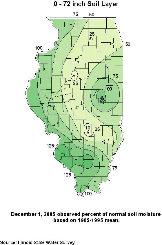
1 Illinois Drought Update, December 1, 2005 DROUGHT RESPONSE TASK FORCE Illinois State Water Survey, Department of Natural Resources For more drought information please go to SUMMARY. The precipitation deficit has increased across northern Illinois and decreased in eastern and southern Illinois. The Northeast and Northwest climate divisions are experiencing their driest March-November periods on record, and the Central climate division is experiencing its 3 rd driest on record. The water levels of many reservoirs in central Illinois are expected to drop over the next two months unless above-normal precipitation occurs, and the potential for drought impacts on water supplies could develop should dry conditions persist through winter and spring. 1. DROUGHT STATUS. According to the U.S. Drought Monitor (Figure 1), most of northern Illinois remains in a severe or extreme drought (categories 2 and 3 in their 4-category drought classification). Much of central Illinois remains in the categories of moderate drought or abnormally dry. Only southern Illinois is considered to be clear of drought. The Drought Monitor is updated each Thursday morning at 8am EDT and can be accessed via the Internet at 2. PRECIPITATION. Statewide precipitation since the last Drought Response Task Force meeting on September 29 has been 5.22 inches, which is 0.99 inches below normal. During that period, southern and eastern Illinois received close to normal precipitation. Meanwhile, northern and western Illinois received amounts that were 1 to 2 inches below normal, leading to worsening precipitation deficits in that region. On a state-wide monthly basis, October was very dry (1.41inches, 1.51 inches below normal) while November was much wetter (3.82 inches, 0.59 inches above normal). Statewide precipitation (Figure 2) since March 1 has been inches (8.58 inches below normal). The area just to the north of Peoria is especially severe with precipitation deficits of 13 to 14 inches since March LAST 100 YEARS. Despite the occurrence of near normal statewide rainfall in four of the last 5 months, the precipitation total in Illinois during the March November 2005 period is the 7th driest such period since 1895 (Figure 3). While March through May was uniformly dry statewide, considerable variability in rainfall totals is observed now on a climate division basis. Above normal rainfall across southern Illinois since June, largely due to an unusual number of tropical systems impacting the state, has brought much the southwest and southeast climate divisions out of drought. However, far northern and portions of central Illinois continue to report very dry precipitation totals. Specifically, the northwest and northeast climate divisions now report the driest March November period on record (Figure 4), while the central, west, and west-southwest divisions report the third to fifth driest such period over the last 111 years. 4. SOIL MOISTURE. Normal precipitation in recent weeks and seasonal reduction in both evaporation and extraction of moisture by plant growth has allowed near surface soil moisture to return toward more normal levels. Nevertheless, moisture in deeper soils remains substantially dry in much of Illinois, observed by the overall pattern in a north-south band across the state
2 (Figure 5). Although near surface moisture will likely be sufficient during the early weeks next year s growing season, above normal precipitation will be needed through the winter and into spring to fully recharge soils in the deeper layers. 5. GROUNDWATER. Water levels at ISWS shallow observation wells at Fermi National Laboratory in DuPage County (15 feet deep) and Bondville in Champaign County (21 feet deep) continue to decline. The levels at both sites are, once again at their lowest readings ever recorded for any month since records began in November 1988 and March 1982, respectively. The water level at Fermi is currently 6.4 feet below normal and at Bondville, the level is 4.1 feet below normal. The dry water table conditions within the central portion of the state are also reflected in the shallow wells stationed at the ICN sites. Of the sixteen wells, only the four centrally located wells have shown declines in water levels this month. All other sites have either leveled off or have reported slightly increased levels. Irrigation demand has stopped within the last few months in northwestern Illinois. As a result, groundwater levels in the deep buried, artesian Sankoty aquifer of Lee, Whiteside, Bureau, and Henry counties continued to recover during November. Meanwhile, groundwater levels in the surficial, water-table aquifer (the Tampico aquifer) continue to fall slowly - declines of 0.2 to 0.9 feet were common. The ISWS has received 6 reports over the last two months from homeowners that are experiencing well problems related to drought conditions. These reports have centered in Champaign and Vermilion counties and all have been using large-diameter bored wells which are particularly prone to problems during dry periods because of their shallow construction depths (typically 25 to 50 feet deep). Groundwater levels are expected to continue their downward trend over the next few months which is typical for this time of the year. However, the previous dry periods are causing an increased decline especially in the north and central parts of the state. 6. ILLINOIS STREAMFLOWS. November streamflows in Illinois (Figure 6) ranged from much below normal in the northwest quadrant of the state, where precipitation deficits are greatest, to normal conditions in eastern Illinois and above normal conditions in southern Illinois. Streamflow rates reached their annual minima during the August through October time period, with many streams in northern Illinois experiencing flows below the 10-year low flow. With the growing season ended, most precipitation is now replenishing soil moisture and leading to increases in runoff and streamflow, following the normal seasonal pattern. However, much above normal amounts of precipitation will be needed over the winter and spring in the northwestern part of the state to return these flow conditions to a normal condition. 7. WATER LEVELS AT PUBLIC WATER SUPPLY (PWS) RESERVOIRS. Figure 7 provides November month-end water levels for 10 selected reservoirs in central Illinois for which the ISWS has recorded monthly levels for at least 16 years. There are relatively few water supply reservoirs located in the northern portion of the state where there precipitation deficit and drought impacts are greatest. The biggest concern for water supply reservoirs is in central Illinois with the possibility of having a dry winter and spring period in which already low reservoirs may not be able to recover to their normal (full) pool levels by the end of spring. Records from past droughts suggest that, without a substantial recovery in streamflow by the spring, we should not expect that Canton Lake, Lake Bloomington, and Lake Evergreen will
3 return to full pool (this may also be the case for other reservoirs in this region where monthly levels are not available). Although less likely, a markedly dry winter and spring could cause other reservoirs in central Illinois such as near Springfield and vicinity to lack a full recovery in water levels, similar to conditions experienced during the spring of the drought. Altamont Lake, located near Effingham, is at its lowest November level in 23 years of record; however this lake is designed to provide water through a 4-year drought period and, as such, the low water levels are not yet a concern. Lake Decatur is now at full pool; pumping from the DeWitt well field was discontinued around November 1. Decatur took several proactive measures to mitigate potential drought impacts, and the Lake Decatur watershed also received timely rainfalls at critical periods throughout the drought to avoid major water supply concerns. 8. FEDERAL RESERVOIRS. Lake Shelbyville and Carlyle Lake are roughly 1.9 and 0.8 feet below their target pool levels, respectively, having risen slightly during November. Although the lakes are at a low seasonal level (their 2 nd and 3 rd lowest levels over the last 20 years at Shelbyville and Carlyle, respectively); the lake levels are still above the normal winter pool level, and water will be released in December to lower the lakes to their winter pools. Rend Lake is at an elevation of feet, which is normal for this time of year. 9. MISSISSIPPI AND OHIO RIVERS. The water levels in the Mississippi and Ohio Rivers are presently at normal to slightly below-normal seasonal levels, which are representative of the overall precipitation conditions over the large watersheds of these rivers. 10. ILLINOIS RIVER. The flow amount in the Illinois River is around 6000 cubic feet per second, which is below normal for this time of year, but nearly double the near-record low levels that persisted throughout much of the summer and early fall. As discussed in previous updates, the near-record low flows on the Illinois were the results of both this year s drought conditions and the general reduction in the Lake Michigan diversion caused by water use conservation and the reduction of leakage through the Chicago Locks. 11. LAKE MICHIGAN. The level of Lake Michigan continues to drop, but at a slower rate during the month of November as a result of substantial rainfall amounts over portions of Michigan and Wisconsin. The average lake level for November 2005 was feet, which is 1.6 feet below the long-term average for November and 0.9 feet above the lowest November conditions recorded in The level in Lake Michigan can be expected to continue dropping through mid-winter as part of its normal seasonal cycle, and potentially could reach low levels similar to those observed over the winter of , when the lake was only 0.5 foot above its record low. 12. OUTLOOK. According to the National Weather Service, the weather over the next two weeks is expected to be colder than average with normal to below-normal precipitation. Their outlook for December-January-February calls for an increased chance of above-normal temperatures; however, they provide no guidance on precipitation. It should be noted that December, January, and February, are normally the three driest months of the year with 2.74, 1.97, and 1.99 inches of precipitation respectively. Much of this precipitation in the northern and central portions of the state falls as snow.

4 Figure 1. U.S. Drought Monitor for November 22, 2005.
5 March 1, 2005, to November 29, 2005, Precipitation Percent of Normal March 1, 2005, to November 29, 2005, Precipitation Departure (inches) Figure 2. Precipitation for the period of March 1 to November 29, 2005, in terms of percent of normal (left) and departure from normal (right). Source: Illinois State Water Survey
6 Figure 3. Ten driest March through November periods in Illinois (since 1895) Rank Year Precip (in) Figure 4. Rankings of driest March through November periods within Illinois climate divisions (since 1895) Climate divisions 2005 rank top 4 driest years Northwest , 1988, 1910, 1895 Northeast , 1971, 1962, 1956 West , 1901, 1953, 1936 Central , 1988, 2005, 1914 East , 1930, 1901, 1988 West-Southwest , 1901, 1930, 1953 East-Southeast , 1914, 1901, 1954 Southwest , 1930, 1953, 1914 Southeast , 1901, 1936, 1940
7

8 Figure 6. November 2005 Streamflow Percentiles
9 Figure 7. November 2005 End-of-Month Water Levels at Selected PWS Reservoirs Current Beginning of reservoir ISWS lake Lowest November Reservoir drawdown record (year) Rank level on record (year)** Altamont Lake -5.7 ft ft (2005) Canton Lake -6.0 ft ft (1989) Lake Pittsfield -2.2 ft ft (1999) Lake Bloomington* ft ft (1988) Evergreen Lake* -4.2 ft ft (1989) Lake Pana -3.2 ft ft (1999) Paris East Lake -2.3 ft ft (1999) Carlinville Lake -2.5 ft ft (1987) Lake Springfield -3.7 ft ft (1988) Spring Lake (Macomb) -1.0 ft ft (1989) Four other water supply reservoirs with more than 16 years of record are at full pool: Lake Decatur, Highland Silver Lake, Kinkaid Lake, Lake Vermilion *Paired reservoirs - the amount of total reduction in reservoir storage for the combination of Lake Bloomington and Evergreen Lake is the 4th lowest for November since records began in the 1980s (behind 1988, 1989, and 2000). **Although some water level records are available for historical droughts such as during the 1950s drought of record, these older values are usually not directly comparable to modern records because of substantial changes over time in either water use, normal pool elevation, or in additional sources of supply. Source: Illinois State Water Survey
January 25, Summary
 January 25, 2013 Summary Precipitation since the December 17, 2012, Drought Update has been slightly below average in parts of central and northern Illinois and above average in southern Illinois. Soil
NIDIS Intermountain West Drought Early Warning System November 21, 2017
 NIDIS Drought and Water Assessment NIDIS Intermountain West Drought Early Warning System November 21, 2017 Precipitation The images above use daily precipitation statistics from NWS COOP, CoCoRaHS, and
Oregon Water Conditions Report April 17, 2017
 Oregon Water Conditions Report April 17, 2017 Mountain snowpack continues to maintain significant levels for mid-april. By late March, statewide snowpack had declined to 118 percent of normal after starting
National Wildland Significant Fire Potential Outlook
 National Wildland Significant Fire Potential Outlook National Interagency Fire Center Predictive Services Issued: September, 2007 Wildland Fire Outlook September through December 2007 Significant fire
Precipitation. Standardized Precipitation Index. NIDIS Intermountain West Drought Early Warning System September 5, 2017
 9/6/2017 NIDIS Drought and Water Assessment NIDIS Intermountain West Drought Early Warning System September 5, 2017 Precipitation The images above use daily precipitation statistics from NWS COOP, CoCoRaHS,
Monthly Long Range Weather Commentary Issued: APRIL 1, 2015 Steven A. Root, CCM, President/CEO
 Monthly Long Range Weather Commentary Issued: APRIL 1, 2015 Steven A. Root, CCM, President/CEO sroot@weatherbank.com FEBRUARY 2015 Climate Highlights The Month in Review The February contiguous U.S. temperature
NIDIS Intermountain West Drought Early Warning System April 18, 2017
 1 of 11 4/18/2017 3:42 PM Precipitation NIDIS Intermountain West Drought Early Warning System April 18, 2017 The images above use daily precipitation statistics from NWS COOP, CoCoRaHS, and CoAgMet stations.
NIDIS Intermountain West Drought Early Warning System February 12, 2019
 NIDIS Intermountain West Drought Early Warning System February 12, 2019 Precipitation The images above use daily precipitation statistics from NWS COOP, CoCoRaHS, and CoAgMet stations. From top to bottom,
Above normal temperatures and precipitation continue across the HSA
 NWS Form E-5 (PRES. BY NWS Instruction 10-924) MONTHLY REPORT OF HYDROLOGIC CONDITIONS HYDROLOGIC SERVICE AREA (HSA) MONTH YEAR TO: Hydrologic Information Center, W/OS31 NOAA s National Weather Service
NIDIS Intermountain West Drought Early Warning System February 6, 2018
 NIDIS Intermountain West Drought Early Warning System February 6, 2018 Precipitation The images above use daily precipitation statistics from NWS COOP, CoCoRaHS, and CoAgMet stations. From top to bottom,
NIDIS Intermountain West Drought Early Warning System November 14, 2017
 NIDIS Intermountain West Drought Early Warning System November 14, 2017 Precipitation The images above use daily precipitation statistics from NWS COOP, CoCoRaHS, and CoAgMet stations. From top to bottom,
NIDIS Intermountain West Regional Drought Early Warning System February 7, 2017
 NIDIS Drought and Water Assessment NIDIS Intermountain West Regional Drought Early Warning System February 7, 2017 Precipitation The images above use daily precipitation statistics from NWS COOP, CoCoRaHS,
Precipitation. Standardized Precipitation Index. NIDIS Intermountain West Regional Drought Early Warning System January 3, 2017
 1/3/2017 NIDIS Drought and Water Assessment NIDIS Intermountain West Regional Drought Early Warning System January 3, 2017 Precipitation The images above use daily precipitation statistics from NWS COOP,
NWS FORM E-5 U.S. DEPARTMENT OF COMMERCE I HYDRO SERVICE AREA NOAA, NATIONAL WEATHER SERVICE I Indianapolis, IN MONTHLY REPORT
 NWS FORM E-5 U.S. DEPARTMENT OF COMMERCE I HYDRO SERVICE AREA NOAA, NATIONAL WEATHER SERVICE I Indianapolis, IN. 1-------------------- MONTHLY REPORT OF RIVER AND FLOOD CONDITIONSI REPORT FOR I November
2018 Year in Review for Central and Southeast Illinois By: Chris Geelhart, Meteorologist National Weather Service, Lincoln IL
 By: Chris Geelhart, Meteorologist National Weather Service, Lincoln IL While 2018 featured some significant out-of-season weather, including below zero temperatures in April and 90-degree highs in early
NIDIS Intermountain West Drought Early Warning System September 4, 2018
 NIDIS Drought and Water Assessment NIDIS Intermountain West Drought Early Warning System September 4, 2018 Precipitation The images above use daily precipitation statistics from NWS COOP, CoCoRaHS, and
Monthly Long Range Weather Commentary Issued: July 18, 2014 Steven A. Root, CCM, President/CEO
 Monthly Long Range Weather Commentary Issued: July 18, 2014 Steven A. Root, CCM, President/CEO sroot@weatherbank.com JUNE 2014 REVIEW Climate Highlights The Month in Review The average temperature for
Thursday, February 20th Issued: 2:30pm CST
 Thursday, February 20th Issued: 2:30pm CST Prepared by: Victor Murphy/Brian Hoeth 817-978-1100 x 147 National Weather Service Southern Region Headquarters Regional Operations Center Fort Worth, TX Current
Weather and Climate Summary and Forecast February 2018 Report
 Weather and Climate Summary and Forecast February 2018 Report Gregory V. Jones Linfield College February 5, 2018 Summary: For the majority of the month of January the persistent ridge of high pressure
2011 Year in Review TORNADOES
 2011 Year in Review The year 2011 had weather events that will be remembered for a long time. Two significant tornado outbreaks in April, widespread damage and power outages from Hurricane Irene in August
Oregon Water Conditions Report May 1, 2017
 Oregon Water Conditions Report May 1, 2017 Mountain snowpack in the higher elevations has continued to increase over the last two weeks. Statewide, most low and mid elevation snow has melted so the basin
Upper Missouri River Basin December 2017 Calendar Year Runoff Forecast December 5, 2017
 Upper Missouri River Basin December 2017 Calendar Year Runoff Forecast December 5, 2017 Calendar Year Runoff Forecast Explanation and Purpose of Forecast U.S. Army Corps of Engineers, Northwestern Division
Current Water Conditions in Massachusetts January 11, 2008
 Current Water Conditions in Massachusetts January 11, 2008 December precipitation was above normal December streamflows were below normal and normal December ground-water levels were below normal and normal
Weather and Climate Summary and Forecast January 2019 Report
 Weather and Climate Summary and Forecast January 2019 Report Gregory V. Jones Linfield College January 4, 2019 Summary: December was mild and dry over much of the west, while the east was much warmer than
NIDIS Intermountain West Drought Early Warning System December 30, 2018
 1/2/2019 NIDIS Drought and Water Assessment NIDIS Intermountain West Drought Early Warning System December 30, 2018 Precipitation The images above use daily precipitation statistics from NWS COOP, CoCoRaHS,
NIDIS Intermountain West Drought Early Warning System March 26, 2019
 NIDIS Intermountain West Drought Early Warning System March 26, 2019 The images above use daily precipitation statistics from NWS COOP, CoCoRaHS, and CoAgMet stations. From top to bottom, and left to right:
2012 Growing Season Weather Summary for North Dakota. Adnan Akyüz and Barbara A. Mullins Department of Soil Science October 30, 2012
 2012 Growing Season Weather Summary for North Dakota Adnan Akyüz and Barbara A. Mullins Department of Soil Science October 30, 2012 Introduction The 2012 growing season (the period from April through September)
Great Lakes Update. Great Lakes Winter and Spring Summary January June Vol. 187 Great Lakes Update August 2012
 Great Lakes Update Great Lakes Winter and Spring Summary January June 2012 The US Army Corps of Engineers (USACE) Detroit District monitors hydraulic and hydrologic conditions of the Great Lakes. This
Monthly Long Range Weather Commentary Issued: February 15, 2015 Steven A. Root, CCM, President/CEO
 Monthly Long Range Weather Commentary Issued: February 15, 2015 Steven A. Root, CCM, President/CEO sroot@weatherbank.com JANUARY 2015 Climate Highlights The Month in Review During January, the average
NIDIS Intermountain West Drought Early Warning System July 18, 2017
 NIDIS Drought and Water Assessment NIDIS Intermountain West Drought Early Warning System July 18, 2017 Precipitation The images above use daily precipitation statistics from NWS COOP, CoCoRaHS, and CoAgMet
NIDIS Intermountain West Drought Early Warning System August 8, 2017
 NIDIS Drought and Water Assessment 8/8/17, 4:43 PM NIDIS Intermountain West Drought Early Warning System August 8, 2017 Precipitation The images above use daily precipitation statistics from NWS COOP,
NATIONAL WEATHER SERVICE
 January 2016 February 9, 2016 This was a dry month across the HSA despite one large and several smaller snowfalls. Most locations ended up 1-2 inches below normal for the month. The driest locations at
NIDIS Intermountain West Drought Early Warning System October 17, 2017
 NIDIS Drought and Water Assessment NIDIS Intermountain West Drought Early Warning System October 17, 2017 Precipitation The images above use daily precipitation statistics from NWS COOP, CoCoRaHS, and
Monthly Long Range Weather Commentary Issued: May 15, 2014 Steven A. Root, CCM, President/CEO
 Monthly Long Range Weather Commentary Issued: May 15, 2014 Steven A. Root, CCM, President/CEO sroot@weatherbank.com APRIL 2014 REVIEW Climate Highlights The Month in Review The average temperature for
SEPTEMBER 2013 REVIEW
 Monthly Long Range Weather Commentary Issued: October 21, 2013 Steven A. Root, CCM, President/CEO sroot@weatherbank.com SEPTEMBER 2013 REVIEW Climate Highlights The Month in Review The average temperature
The hydrologic service area (HSA) for this office covers Central Kentucky and South Central Indiana.
 for this office covers Central Kentucky and South Central Indiana.") January 2012 February 13, 2012 An X inside this box indicates that no flooding occurred within this hydrologic service area. January 2012 continued the string of wet months this winter. Rainfall was generally
January 2012 February 13, 2012 An X inside this box indicates that no flooding occurred within this hydrologic service area. January 2012 continued the string of wet months this winter. Rainfall was generally
Thursday, March 19, 2015 Issued: 1:00pm CDT
 Thursday, March 19, 2015 Issued: 1:00pm CDT Prepared by: Kurt Van Speybroeck/Victor Murphy/David Brown 817-978-1100 x 147 National Weather Service Southern Region Headquarters Regional Operations Center
NIDIS Intermountain West Drought Early Warning System January 16, 2018
 NIDIS Drought and Water Assessment NIDIS Intermountain West Drought Early Warning System January 16, 2018 Precipitation The images above use daily precipitation statistics from NWS COOP, CoCoRaHS, and
NIDIS Intermountain West Drought Early Warning System October 30, 2018
 10/30/2018 NIDIS Drought and Water Assessment NIDIS Intermountain West Drought Early Warning System October 30, 2018 Precipitation The images above use daily precipitation statistics from NWS COOP, CoCoRaHS,
January 2011 Calendar Year Runoff Forecast
 January 2011 Calendar Year Runoff Forecast 2010 Runoff Year Calendar Year 2010 was the third highest year of runoff in the Missouri River Basin above Sioux City with 38.8 MAF, behind 1978 and 1997 which
The 2005 Illinois Drought a
 Informational/Educational Material 2006-03 The 2005 Illinois Drought a by Kenneth E. Kunkel (editor), James R. Angel, Stanley A. Changnon, Roger Claybrooke, Steven D. Hilberg, H. Vernon Knapp, Robert S.
NIDIS Intermountain West Drought Early Warning System December 18, 2018
 NIDIS Intermountain West Drought Early Warning System December 18, 2018 Precipitation The images above use daily precipitation statistics from NWS COOP, CoCoRaHS, and CoAgMet stations. From top to bottom,
NIDIS Intermountain West Drought Early Warning System May 23, 2017
 NIDIS Drought and Water Assessment NIDIS Intermountain West Drought Early Warning System May 23, 2017 Precipitation The images above use daily precipitation statistics from NWS COOP, CoCoRaHS, and CoAgMet
Weather and Climate Summary and Forecast March 2018 Report
 Weather and Climate Summary and Forecast March 2018 Report Gregory V. Jones Linfield College March 7, 2018 Summary: The ridge pattern that brought drier and warmer conditions from December through most
Weather and Climate Summary and Forecast January 2018 Report
 Weather and Climate Summary and Forecast January 2018 Report Gregory V. Jones Linfield College January 5, 2018 Summary: A persistent ridge of high pressure over the west in December produced strong inversions
NIDIS Intermountain West Drought Early Warning System February 19, 2019
 NIDIS Intermountain West Drought Early Warning System February 19, 2019 Precipitation The images above use daily precipitation statistics from NWS COOP, CoCoRaHS, and CoAgMet stations. From top to bottom,
NIDIS Weekly Climate, Water and Drought Assessment Summary. Upper Colorado River Basin
 NIDIS Weekly Climate, Water and Drought Assessment Summary Upper Colorado River Basin August 3, 2010 Precipitation and Snowpack Fig. 1: July precipitation in inches Fig. 2: July precip as percent of average
NIDIS Intermountain West Drought Early Warning System January 15, 2019
 NIDIS Drought and Water Assessment NIDIS Intermountain West Drought Early Warning System January 15, 2019 Precipitation The images above use daily precipitation statistics from NWS COOP, CoCoRaHS, and
Precipitation. Standardized Precipitation Index. NIDIS Intermountain West Regional Drought Early Warning System December 6, 2016
 12/9/2016 NIDIS Drought and Water Assessment NIDIS Intermountain West Regional Drought Early Warning System December 6, 2016 Precipitation The images above use daily precipitation statistics from NWS COOP,
NIDIS Drought and Water Assessment
 NIDIS Drought and Water Assessment PRECIPITATION The images above use daily precipitation statistics from NWS COOP, CoCoRaHS, and CoAgMet stations. From top to bottom, and left to right: most recent 7-days
NIDIS Intermountain West Drought Early Warning System May 1, 2018
 NIDIS Intermountain West Drought Early Warning System May 1, 2018 Precipitation The images above use daily precipitation statistics from NWS COOP, CoCoRaHS, and CoAgMet stations. From top to bottom, and
March 1, 2003 Western Snowpack Conditions and Water Supply Forecasts
 Natural Resources Conservation Service National Water and Climate Center 101 SW Main Street, Suite 1600 Portland, OR 97204-3224 Date: March 17, 2003 Subject: March 1, 2003 Western Snowpack Conditions and
The following information is provided for your use in describing climate and water supply conditions in the West as of April 1, 2003.
 Natural Resources Conservation Service National Water and Climate Center 101 SW Main Street, Suite 1600 Portland, OR 97204-3224 Date: April 8, 2003 Subject: April 1, 2003 Western Snowpack Conditions and
NIDIS Intermountain West Drought Early Warning System April 16, 2019
 NIDIS Intermountain West Drought Early Warning System April 16, 2019 Precipitation The images above use daily precipitation statistics from NWS COOP, CoCoRaHS, and CoAgMet stations. From top to bottom,
NIDIS Intermountain West Drought Early Warning System November 13, 2018
 NIDIS Intermountain West Drought Early Warning System November 13, 2018 Precipitation The images above use daily precipitation statistics from NWS COOP, CoCoRaHS, and CoAgMet stations. From top to bottom,
Great Lakes Update. Volume 193: 2015 January through June Summary. Vol. 193 Great Lakes Update August 2015
 Great Lakes Update Volume 193: 2015 January through June Summary The U.S. Army Corps of Engineers (USACE) monitors the water levels of each of the Great Lakes. This report provides a summary of the Great
The 1986 Southeast Drought in Historical Perspective
 The Southeast Drought in Historical Perspective Abstract The dry and hot weather in the southeast United States during the first seven months of caused record drought. The agricultural and hydrological
Souris River Basin Spring Runoff Outlook As of March 1, 2019
 Souris River Basin Spring Runoff Outlook As of March 1, 2019 Prepared by: Flow Forecasting & Operations Planning Water Security Agency Basin Conditions Summer rainfall in 2018 over the Saskatchewan portion
The Pennsylvania Observer
 The Pennsylvania Observer April 2, 2009 March 2009 Pennsylvania Weather Recap Prepared by Curt Harpster For the month of March the saying, In like a lion and out like a lamb really fit the pattern quite
Midwest/Great Plains Climate-Drought Outlook September 20, 2018
 Midwest/Great Plains Climate-Drought Outlook September 20, 2018 Brian Fuchs National Drought Mitigation Center University of Nebraska-Lincoln School of Natural Resources September 20, 2018 General Information
NIDIS Intermountain West Drought Early Warning System December 11, 2018
 NIDIS Drought and Water Assessment NIDIS Intermountain West Drought Early Warning System December 11, 2018 Precipitation The images above use daily precipitation statistics from NWS COOP, CoCoRaHS, and
Investigation IV: Seasonal Precipitation and Seasonal Surface Runoff in the US
 Investigation IV: Seasonal Precipitation and Seasonal Surface Runoff in the US Purpose Students will consider the seasonality of precipitation and surface runoff and think about how the time of year can
Current Climate Trends and Implications
 Current Climate Trends and Implications Dr. Mark Seeley Professor emeritus Department of Soil, Water, and Climate University of Minnesota St Paul, MN 55108 Crop Insurance Conference September 12, 2018
2011 National Seasonal Assessment Workshop for the Eastern, Southern, & Southwest Geographic Areas
 2011 National Seasonal Assessment Workshop for the Eastern, Southern, & Southwest Geographic Areas On January 11-13, 2011, wildland fire, weather, and climate met virtually for the ninth annual National
Weather and Climate Summary and Forecast Winter
 Weather and Climate Summary and Forecast Winter 2016-17 Gregory V. Jones Southern Oregon University February 7, 2017 What a difference from last year at this time. Temperatures in January and February
Water Supply Conditions and Outlook October 1, 2018
 Water Supply Conditions and Outlook October 1, 2018 Flow Forecasting & Operations Planning Water Security Agency Overview Water supply conditions across Saskatchewan remain near normal, with most reservoirs
Water Availability and Drought Conditions Report. October 2015
 Water Availability and Drought Conditions Report October 2015 Executive Summary The Water Availability and Drought Conditions Report provides an update on drought conditions throughout Manitoba for October
January 2008 Climate Summary
 Joseph Mays (765) 494-6574 Feb 5, 2008 http://www.iclimate.org Summary January 2008 Climate Summary January was a mix bag of conditions, with an oscillatory pattern developing. We experienced phases of
Weather and Climate Summary and Forecast October 2018 Report
 Weather and Climate Summary and Forecast October 2018 Report Gregory V. Jones Linfield College October 4, 2018 Summary: Much of Washington, Oregon, coastal California and the Bay Area and delta region
NATIONAL WEATHER SERVICE
 NWS Form E-5 (PRES. BY NWS Instruction 10-924) MONTHLY REPORT OF HYDROLOGIC CONDITIONS HYDROLOGIC SERVICE AREA (HSA) NORTHERN INDIANA (IWX) MONTH YEAR TO: Hydrologic Information Center, W/OS31 NOAA s National
Weather and Climate Summary and Forecast Summer into Harvest 2016
 Weather and Climate Summary and Forecast Summer into Harvest 2016 Gregory V. Jones Southern Oregon University September 3, 2016 With school and football season starting a hint of fall is right on time
Upper Missouri River Basin February 2018 Calendar Year Runoff Forecast February 6, 2018
 Upper Missouri River Basin February 2018 Calendar Year Runoff Forecast February 6, 2018 Calendar Year Runoff Forecast Explanation and Purpose of Forecast U.S. Army Corps of Engineers, Northwestern Division
Weather and Climate Summary and Forecast April 2018 Report
 Weather and Climate Summary and Forecast April 2018 Report Gregory V. Jones Linfield College April 4, 2018 Summary: A near Miracle March played out bringing cooler and wetter conditions to the majority
The Pennsylvania Observer
 The Pennsylvania Observer January 5, 2009 December 2008 Pennsylvania Weather Recap The final month of 2008 was much wetter than average and a bit colder than normal. In spite of this combination, most
Monthly Long Range Weather Commentary Issued: SEPTEMBER 19, 2016 Steven A. Root, CCM, Chief Analytics Officer, Sr. VP,
 Monthly Long Range Weather Commentary Issued: SEPTEMBER 19, 2016 Steven A. Root, CCM, Chief Analytics Officer, Sr. VP, sroot@weatherbank.com SEPTEMBER 2016 Climate Highlights The Month in Review The contiguous
KANSAS CLIMATE SUMMARY January 2018
 KANSAS CLIMATE SUMMARY January 2018 Some welcome moisture After an extended period with little to no moisture, parts of Kansas recorded some significant precipitation. At Tribune, a small snow event on
KANSAS CLIMATE SUMMARY February 2017
 KANSAS CLIMATE SUMMARY February 2017 Warm and dry February was much warmer and drier than normal. The state-wide average temperature was 41.9 o F, which is 7.9 degrees warmer than normal. This places it
Water Availability and Drought Conditions Report. September 2016
 Water Availability and Drought Conditions Report September 2016 Executive Summary This Water Availability and Drought Conditions Report provides an update on drought conditions throughout Manitoba for
Monthly Long Range Weather Commentary Issued: APRIL 25, 2016 Steven A. Root, CCM, Chief Analytics Officer, Sr. VP, sales
 Monthly Long Range Weather Commentary Issued: APRIL 25, 2016 Steven A. Root, CCM, Chief Analytics Officer, Sr. VP, sales sroot@weatherbank.com MARCH 2016 Climate Highlights The Month in Review The March
The hydrologic service area (HSA) for this office covers Central Kentucky and South Central Indiana.
 for this office covers Central Kentucky and South Central Indiana.") MONTH YEAR January 2011 February 15, 2011 X An X inside this box indicates that no flooding occurred within this hydrologic service area. January 2011 was drier than normal in all locations in the area.
MONTH YEAR January 2011 February 15, 2011 X An X inside this box indicates that no flooding occurred within this hydrologic service area. January 2011 was drier than normal in all locations in the area.
The Pennsylvania Observer
 The Pennsylvania Observer May 31, 2012 May 2012 - Pennsylvania Weather Recap By: Paul Knight The majority of the fifth month had temperatures averaging well above seasonal levels with two distinct hot
Weather and Climate Summary and Forecast March 2019 Report
 Weather and Climate Summary and Forecast March 2019 Report Gregory V. Jones Linfield College March 2, 2019 Summary: Dramatic flip from a mild winter to a top five coldest February on record in many locations
Table 1. Illinois Precipitation (inches) and Temperature (BF) by Crop Reporting District
 and Temperature (BF) by Crop Reporting District") ILLINOIS DEPARTMENT OF NATURAL RESOURCES Illinois State Water Survey Derek Winstanley, Chief 04 Griffith Dr., Champaign, IL 610 Tel (1) 333-10 Fax (1) 333-65 ILLINOIS WATER AND CLIMATE SUMMARY February
ILLINOIS DEPARTMENT OF NATURAL RESOURCES Illinois State Water Survey Derek Winstanley, Chief 04 Griffith Dr., Champaign, IL 610 Tel (1) 333-10 Fax (1) 333-65 ILLINOIS WATER AND CLIMATE SUMMARY February
Weather and Climate Summary and Forecast Summer 2016
 Weather and Climate Summary and Forecast Summer 2016 Gregory V. Jones Southern Oregon University August 5, 2016 The month of July saw the continued flip, flop of the western US temperatures. It was warm
July 2007 Climate Summary
 Dan Bowman (765) 494-6574 Sep 3, 2007 http://www.iclimate.org Summary July 2007 Climate Summary The month of July ended as a very unusual month. Many events occurred during the month of July that is not
Wind River Indian Reservation and Surrounding Area Climate and Drought Summary
 Northern Arapaho Tribe Wind River Indian Reservation and Surrounding Area Climate and Drought Summary Spring Events & Summer Outlook 2015 Spring Was Warm And Very Wet Across The Region The spring season
Monthly Long Range Weather Commentary Issued: APRIL 18, 2017 Steven A. Root, CCM, Chief Analytics Officer, Sr. VP,
 Monthly Long Range Weather Commentary Issued: APRIL 18, 2017 Steven A. Root, CCM, Chief Analytics Officer, Sr. VP, sroot@weatherbank.com MARCH 2017 Climate Highlights The Month in Review The average contiguous
Monthly Long Range Weather Commentary Issued: NOVEMBER 16, 2015 Steven A. Root, CCM, Chief Analytics Officer, Sr. VP, sales
 Monthly Long Range Weather Commentary Issued: NOVEMBER 16, 2015 Steven A. Root, CCM, Chief Analytics Officer, Sr. VP, sales sroot@weatherbank.com OCTOBER 2015 Climate Highlights The Month in Review The
 October 16 th, 2012 2010-12 La Niña event reached its biggest peak since the mid-70s in late 2010, followed by a brief excursion to ENSOneutral conditions during mid-2011; it reached a second peak last
Water Availability and Drought Conditions Report. August 2016
 Water Availability and Drought Conditions Report August 2016 Executive Summary This Water Availability and Drought Conditions Report provides an update on drought conditions throughout Manitoba for August
February 10, Mr. Jeff Smith, Chairman Imperial Valley Water Authority E County Road 1000 N Easton, IL Dear Chairman Smith:
 February 1, 1 Mr. Jeff Smith, Chairman Imperial Valley Water Authority 8 E County Road 1 N Easton, IL Dear Chairman Smith: The Illinois State Water Survey (ISWS), under contract to the Imperial Valley
The Pennsylvania Observer
 The Pennsylvania Observer October 1, 2015 September 2015 - Pennsylvania Weather Recap By: Quinn Lease The month of September will be remembered for its above normal temperatures and dry conditions that
-Assessment of current water conditions. - Precipitation Forecast. - Recommendations for Drought Monitor
 April 27, 2010 -Assessment of current water conditions - Precipitation Forecast - Recommendations for Drought Monitor 7 Day Precipitation 19-25 April 2010 Month-to-Date Precipitation 1-25 April 2010
A summary of the weather year based on data from the Zumwalt weather station
 ZUMWALT PRAIRIE WEATHER 2016 A summary of the weather year based on data from the Zumwalt weather station Figure 1. An unusual summer storm on July 10, 2016 brought the second-largest precipitation day
Weather and Climate Summary and Forecast Fall/Winter 2016
 Weather and Climate Summary and Forecast Fall/Winter 2016 Gregory V. Jones Southern Oregon University November 5, 2016 After a year where we were seemingly off by a month in terms of temperatures (March
Weather and Climate Summary and Forecast Summer 2016
 Weather and Climate Summary and Forecast Summer 2016 Gregory V. Jones Southern Oregon University June 6, 2016 May 2016 continued the warm trend for portions of the west, while providing some relief for
Champaign-Urbana 1999 Annual Weather Summary
 Champaign-Urbana 1999 Annual Weather Summary ILLINOIS STATE WATER SURVEY 2204 Griffith Dr. Champaign, IL 61820 wxobsrvr@sws.uiuc.edu Maria Peters, Weather Observer A major snowstorm kicked off the new
Central Region Climate Outlook May 15, 2014
 Central Region Climate Outlook May 15, 2014 Dr. Jim Angel State Climatologist IL State Water Survey University of Illinois jimangel@illinois.edu 217-333-0729 Chicago-area flooding General Information Providing
Great Lakes Update. Volume 199: 2017 Annual Summary. Background
 Great Lakes Update Volume 199: 2017 Annual Summary Background The U.S. Army Corps of Engineers (USACE) tracks and forecasts the water levels of each of the Great Lakes. This report is primarily focused
Weather and Climate Summary and Forecast August 2018 Report
 Weather and Climate Summary and Forecast August 2018 Report Gregory V. Jones Linfield College August 5, 2018 Summary: July 2018 will likely go down as one of the top five warmest July s on record for many