Partnering with LANDFIRE, NatureServe, and Heritage Programs. Utilizing Legacy Data for Ecological Site Concept Development and Descriptions
|
|
|
- Georgia Anthony
- 5 years ago
- Views:
Transcription
1 Partnering with LANDFIRE, NatureServe, and Heritage Programs Utilizing Legacy Data for Ecological Site Concept Development and Descriptions
2 Content LANDFIRE: BpS vs. EVT LANDFIRE: Disturbance Models NatureServe: Ecological Systems, Associations, and Alliances NatureServe: SWAPs, EOs, and a CIG Grant Heritage Data: MNDNR Heritage Data: INHS Questions
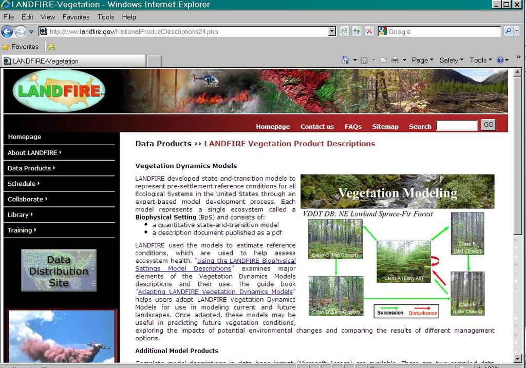
3 What is LANDFIRE? LANDFIRE (also known as Landscape Fire and Resource Management Planning Tools) is an interagency vegetation, fire, and fuel characteristics mapping program, sponsored by the United States Department of the Interior (DOI) and the United States Department of Agriculture, Forest Service. 30-meter grid spatial resolution raster data sets; Over 50 spatial data layers in the form of maps and other data that support a range of land management analysis and modeling: Existing Vegetation Type, Canopy, and Height; Biophysical Settings; Environmental Site Potential; Fire Behavior Fuel Models, Fire Regime Classes, and Fire Effects layers. Data products developed through advanced scientific procedures, including relational databases, georeferenced land based plots, satellite enabled remote sensing, systems ecology, gradient analysis, predictive landscape modeling, and vegetation and disturbance dynamics.
4 With LANDFIRE, you can: view and download geospatial layers and data products that depict the nation's major ecosystems, wildlife habitat, vegetation, landscape features, and fire behavior, effects, and regimes; Provide regional, landscape-scale cross-boundary geospatial products to support fire and fuels management planning and natural resource assessment; Supplement planning and management activities, including monitoring, that require analysis of consistent vegetation data across political boundaries; Analyze and model vegetation, both historic and current, and model effects of natural disturbance

5

6

7
8
9
10
11

12
13
14 What is NatureServe? Nonprofit conservation organization whose mission is to provide the scientific basis for effective conservation action. The leading source for information about rare and endangered species and threatened ecosystems. Represents an international network of independent member programs operating throughout most of the Western Hemisphere. Collect and manage detailed local information on plants, animals, and their habitats, and also develop information products, data management tools, and conservation services to help meet local, national, and global conservation needs.
15 What does NatureServe Do? Provide information products and conservation services to guide natural resource decision-making; Develop comprehensive databases on at-risk species and ecological communities; Establish scientific standards for biological inventory and biodiversity data management, and design advanced biodiversity data management systems; Support the work of member programs to identify, understand, and protect critical natural areas and special places; Make biodiversity information readily available through our websites, publications, and custom services
16


17
18
19 How one Conservation Innovation Grant is shaping Ecological Site Development in the Upper Midwest


20 Project Areas MLRA 93A MLRA 105
21 Project Objectives: 1. Contribute to the development of ESDs by linking NatureServe data, technology, and expertise with ESD development. enhance the regional significance and context appropriateness of ESDs easier to compare ESDs within or across MLRA boundaries based on their links to Ecological Systems units. Links to Associations will provide information on floristic composition, community dynamics, and environmental characteristics that could help inform ESDs. 2. Expand the NatureServe Wildlife Habitat Characterization database to all of the project area. After the ESDs and USNVC are linked, NatureServe would develop an innovative enhancement to the Wildlife Interpretation section of ESDs. NatureServe has developed a Habitat Characterization database to monitor the relationship of species to habitats. include a generalized process for applying a habitat based approach to addressing at risk biodiversity, enhancing the ability to apply standards efficiently for conserving at risk biodiversity. 3. Assist NRCS in presenting wildlife habitat data to producers through NatureServe s wildlife, EO, and SWAP databases. These data can help producers both identify possible habitat and species of concern on their lands and identify possible ways that conservation management would enhance this habitat.
22 Summary: LANDFIRE BpSs/NatureServe s Systems can help us establish broad categories for reference communities or ecological site concepts, and visualize where they were located on the landscape; Existing Vegetation layers can assist with locating and providing information on alternative states, or can help locate reference conditions for sampling; Environmental Site Potential & Vegetation Dynamics Development Tool (VDDT) can help guide State & Transition Model development and biomass/productivity estimates; NatureServe s Associations can help define states or phases, especially where heritage data is limited or not digitized. Partnerships with LANDFIRE can assist with interpretation of data and modeling of disturbances across states; Partnerships with NatureServe can assist with beginning stages of ES concept development, provide regional assessments and crosswalking, and a wealth of wildlife, habitat, and ecosystem data that has been regionalized across political boundaries.
23 When you re lucky enough to have heritage data

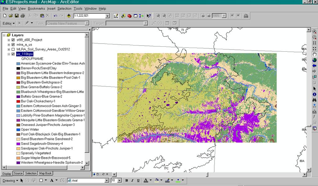
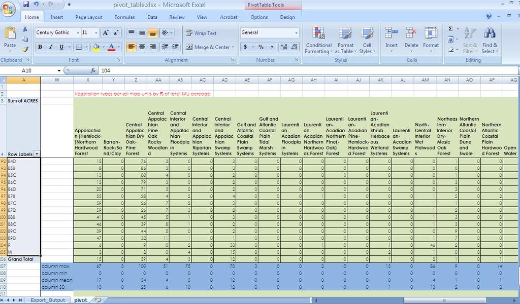
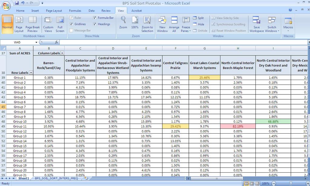
24 Integrating MN CBS Vegetation Data with Soils Groups
25
26 Illinois Natural History Survey: Summary Statistics Dry Mesic Woodland
27 Cluster Analysis What it does Classifies units into discrete groups Uses a hierarchal, polythetic process Several methods of group linkage possible Displays final groups as a dendrogram Will produce distinctive chain if data are truly not linked or if linkage methods are not appropriate Things to keep in mind Groups that combine earlier in the process are more similar to each other than those that get grouped later Later groupings are constrained by early groupings Interpretation of the dendrogram usually involves applying a decision rule to identify natural groups Important to standardize or relativize data
28 Illinois Natural History Survey: Cluster Analysis Dry Mesic Upland Forest
29 Ordination Multivariate Approach The displaying of a swarm of data points in a two or threedimensional coordinate frame so as to make the relationships among the points in many-dimensional space visible on inspection" (Pielou 1984). Arranges data groups along axes on the basis of variables within the group. Many approaches to ordination, must know your data and the constraints of each approach Results cannot really be cross-checked with other analyses, so must use interpretations of stress (NMS) and randomization tests

30 If Attempting Ordinations, YOU NEED THIS BOOK: (and preferably, lots of training!)
31 Axis 2 NRI Data: Ordinations Ken Spaeth, NRCS Rangeland Management Specialist MLRA 86A horizon_ 86_A_ flood clay_sur cec7_r ph_h ph_r ph_l om_h om_r sar_r sand_sur surf_tex ksat_cl bulk_den sar_h slope_l slope_r slope_h Axis 1
32 NRI Data: Ordinations Ken Spaeth, NRCS Rangeland Management Specialist
33 10/21/
34 34 10/21/2015 Data Analysis Summary: Having lots of data can be a blessing, but be careful how you use it! Summary Statistics can help identify and illustrate vegetation or soil characteristics of groups. Cluster Analysis can illustrate which groups of data are potential separate ecological sites, states, or phases based on unique criteria. Ordinations will group data for you and determine which criteria are indicators for each group

35 Questions? Stacey Clark, ESI QA Specialist, MO-10 & Jackson St., Suite 600 St. Paul, MN
Ecological Site Description Overview
 Ecological Site Description Overview 2018 Coastal Zone Soil Survey (CZSS) Work Planning Conference Savannah, GA January 9th, 2018 Greg Taylor Senior Regional Soil Scientist USDA-NRCS Raleigh, NC j.greg.taylor@nc.usda.gov
Ecological Site Descriptions ESDs : NRCS Site-based Approach to Land Classification and Evaluation. Nels Barrett, NRCS Ecologist SSSSNE 20
 Ecological Site Descriptions ESDs : NRCS Site-based Approach to Land Classification and Evaluation Nels Barrett, NRCS Ecologist SSSSNE 20 Overview Definition of Ecological Sites, ES Content of Ecological
An Introduction to Day Two. Linking Conservation and Transportation Planning Lakewood, Colorado August 15-16, 16, 2006
 An Introduction to Day Two Linking Conservation and Transportation Planning Lakewood, Colorado August 15-16, 16, 2006 1 Agenda Day One Transportation Planning Heritage Program State Wildlife Action Plan
An Introduction to NatureServe Linking Conservation and Transportation Planning Phoenix, Arizona November 8 & 9, 2006
 An Introduction to NatureServe Linking Conservation and Transportation Planning Phoenix, Arizona November 8 & 9, 2006 1 NatureServe in Brief An independent, non-profit conservation organization Provides
Ecological Response Units Ecosystem Mapping System for the Southwest US
 Ecological Response Units Ecosystem Mapping System for the Southwest US J. C. Moreland, W. A. Robbie, F. J. Triepke, E. H. Muldavin, and J. R. Malusa Objectives What are Ecological Response Units? What
A Regional Database Tracking Fire Footprint Each Year within the South Atlantic Region: Current Database Description and Future Directions
 A Regional Database Tracking Fire Footprint Each Year within the South Atlantic Region: Current Database Description and Future Directions Last Updated on September 30, 2018 Contributors: NatureServe,
Landscape Planning and Habitat Metrics
 Landscape Planning and Habitat Metrics Frank W. Davis National Center for Ecological Analysis and Synthesis UC Santa Barbara (Tools for Landscape Biodiversity Planning) Jimmy Kagan Institute for Natural
ESD Workshop Poster Session
 ESD Workshop Poster Session A Brief Introduction January 28, 2012 Mobile Soil Survey for Interpreting and Developing ESDs Synergy Resource Solutions, Inc Mark Hendrix Calli Oiestad Melissa Kelson Jack
Utility of National Spatial Data for Conservation Design Projects
 Utility of National Spatial Data for Conservation Design Projects Steve Williams Biodiversity and Spatial Information Center North Carolina State University PIF CDW St. Louis, MO April 11, 2006 Types of
Ecological Land Cover Classification For a Natural Resources Inventory in the Kansas City Region, USA
 Ecological Land Cover Classification For a Natural Resources Inventory in the Kansas City Region, USA by Applied Ecological Services, Inc. In cooperation with the Mid-America Regional Council 600 Broadway,
Geospatial Data, Services, and Products. National Surveying, mapping and geospatial conference
 Geospatial Data, Services, and Products Federal Programs -- USDA NRCS National Surveying, mapping and geospatial conference March 15, 2016 NRCS Applications using Geosaptial Products & Services Field
Looking at the big picture to plan land treatments
 Looking at the big picture to plan land treatments Eva Strand Department of Rangeland Ecology and Management University of Idaho evas@uidaho.edu, http://www.cnr.uidaho.edu/range Why land treatment planning?
The Invasion of False Brome in Western Oregon
 The Invasion of False Brome in Western Oregon GIS II Presentation Winter 2006 Will Fellers Kurt Hellerman Kathy Strope Statia Cupit False Brome (Brachypodium sylvaticum) Perennial bunchgrass native to
Global reviews of wetland inventory, classification and delineation
 Max Finlayson Institute for Land, Water & Society Charles Sturt University Albury, Australia Global reviews of wetland inventory, classification and delineation Initiatives/meetings over two decades have
Overview. Project Background Project Approach: Content and Application Development Application Demonstration Future Developments
 Overview Project Background Project Approach: Content and Application Development Application Demonstration Future Developments Southeast Pressures: Continued Population Growth Transportation Corridors
Development of statewide 30 meter winter sage grouse habitat models for Utah
 Development of statewide 30 meter winter sage grouse habitat models for Utah Ben Crabb, Remote Sensing and Geographic Information System Laboratory, Department of Wildland Resources, Utah State University
Southwest LRT Habitat Analysis. May 2016 Southwest LRT Project Technical Report
 Southwest LRT Habitat Analysis Southwest LRT Project Technical Report This page intentionally blank. Executive Summary This technical report describes the habitat analysis that was performed to support
NATIONAL VEGETATION CLASSIFICATION STANDARD, VERSION 2 WORKING DRAFT
 NATIONAL VEGETATION CLASSIFICATION STANDARD, VERSION 2 WORKING DRAFT Subcommittee Federal Geographic Data Committee SUMMMARY NatureServe version 31 August 2006 INTRODUCTION The United States Federal Geographic
Just as ecological systems are dynamic, so too are the
 Society for Range Management Information Technologies and Ecological Site Descriptions By Curtis J. Talbot, Steven B. Campbell, Michael Hansen, and Alan B. Price Just as ecological systems are dynamic,
Assessment and valuation of Ecosystem Services for decision-makers
 Assessment and valuation of Ecosystem Services for decision-makers An introduction to the ARIES approach Ferdinando Villa *, Ken Bagstad Gary Johnson, Marta Ceroni *Basque Center for Climate Change, Bilbao,
Geographic Information Infrastructure and Policy Framework for Sustainable Mountain Development in the Hindu Kush-Himalayas
 Geo SMART ASIA 2017 22-24 August, Kualalampur Geographic Information Infrastructure and Policy Framework for Sustainable Mountain Development in the Hindu Kush-Himalayas Basanta Shrestha, Director Strategic
Appendix P San Joaquin Valley Greenprint
 Appendix P San Joaquin Valley Greenprint TCAG 2014 Regional Transportation Plan San Joaquin Valley Greenprint Data Supplement for SCS Planning And Impact Assessment 3/25/2013 This document is intended
Data sources and classification for ecosystem accounting g
 Data sources and classification for ecosystem accounting Ken Bagstad 23 February 2015 Wealth Accounting and the Valuation of Ecosystem Services www.wavespartnership.org Data sources and classification
Data Dictionary for Network of Conservation Areas Transcription Reports from the Colorado Natural Heritage Program
 Data Dictionary for Network of Conservation Areas Transcription Reports from the Colorado Natural Heritage Program This Data Dictionary defines terms used in Network of Conservation Areas (NCA) Reports
3/29/11. Why bother with tools? Incorporating Decision Support Tools into Climate Adaptation Planning. A Simplified Planning Process
 Incorporating Decision Support Tools into Climate Adaptation Planning Why bother with tools? Tools don t eliminate complexity but they can help deal with it" Tools can:"! Help incorporate science into
USGS National Geospatial Program Understanding User Needs. Dick Vraga National Map Liaison for Federal Agencies July 2015
 + USGS National Geospatial Program Understanding User Needs Dick Vraga National Map Liaison for Federal Agencies July 2015 + Topics 2 Background Communities of Use User Surveys National Map Liaisons Partnerships
Land Use MTRI Documenting Land Use and Land Cover Conditions Synthesis Report
 Colin Brooks, Rick Powell, Laura Bourgeau-Chavez, and Dr. Robert Shuchman Michigan Tech Research Institute (MTRI) Project Introduction Transportation projects require detailed environmental information
Garlic Mustard Distribution
 Garlic Mustard Distribution Brian Adair Solye Brown Alliaria Petiolata (garlic mustard) Biennial Brought to North America as a culinary and medicinal herb (useful treating skin ulcers, throat infections,
ENVI Tutorial: Vegetation Analysis
 ENVI Tutorial: Vegetation Analysis Vegetation Analysis 2 Files Used in this Tutorial 2 About Vegetation Analysis in ENVI Classic 2 Opening the Input Image 3 Working with the Vegetation Index Calculator
Puakea, Hawaiÿi. Puakea, Hawaiÿi WATERSHED FEATURES
 Puakea, Hawaiÿi DAR Watershed Code: 85046 Puakea, Hawaiÿi WATERSHED FEATURES Puakea watershed occurs on the island of Hawaiÿi. The Hawaiian meaning of the name is white blossom. The area of the watershed
Ecology is studied at several levels
 Ecology is studied at several levels Ecology and evolution are tightly intertwined Biosphere = the total living things on Earth and the areas they inhabit Ecosystem = communities and the nonliving material
Observation (EO) & Geomatics in Canada
 & Geomatics in Canada") Innovating to Increase the Impact of Earth Observation (EO) & Geomatics in Canada Natural Resources Canada February 25, 2014 Prashant Shukle, Director General Canada Centre for Mapping and Earth Observation
Innovating to Increase the Impact of Earth Observation (EO) & Geomatics in Canada Natural Resources Canada February 25, 2014 Prashant Shukle, Director General Canada Centre for Mapping and Earth Observation
Ecological mapping using satellite imagery: an Abu Dhabi case study Middle East Geospatial Forum 16 th February 2015
 Ecological mapping using satellite imagery: an Abu Dhabi case study Middle East Geospatial Forum 16 th February 2015 Richard Flemmings rf@proteusgeo.com About Proteus Formed in UAE 2011 We specialise in
1.1 What is Site Fingerprinting?
 Site Fingerprinting Utilizing GIS/GPS Technology 1.1 What is Site Fingerprinting? Site fingerprinting is a planning tool used to design communities where protection of natural resources is the primary
THE NATURESERVE NETWORK
 THE NATURESERVE NETWORK Access to NatureServe's best available data on the locations of endangered species September 1, 2011 A Network Connecting Science with Conservation Mexico Guatemala El Salvador
An Update on Land Use & Land Cover Mapping in Ireland
 An Update on Land Use & Land Cover Mapping in Ireland Progress Towards a National Programme Kevin Lydon k.lydon@epa.ie Office of Environmental Assessment, Environmental Protection Agency, Johnstown Castle,
Natural Resource Management. Northern Tasmania. Strategy. Appendix 2
 Natural Resource Management Strategy Northern Tasmania 2015 2020 Appendix 2 Appendix 2 Appendix 2. Carbon Planting Spatial Prioritisation In support of this Strategy s development and implementation, work
Draft Biodiversity, Fire, and Fuels Integrated Plan
 Marin Municipal Water District Draft Biodiversity, Fire, and Fuels Integrated Plan September 15, 2016 One Embarcadero Center, Suite 740 San Francisco, CA 94111 650-373-1200 www.panoramaenv.com Marin Municipal
A Comprehensive Inventory of the Number of Modified Stream Channels in the State of Minnesota. Data, Information and Knowledge Management.
 A Comprehensive Inventory of the Number of Modified Stream Channels in the State of Minnesota Data, Information and Knowledge Management Glenn Skuta Environmental Analysis and Outcomes Division Minnesota
Linking local multimedia models in a spatially-distributed system
 Linking local multimedia models in a spatially-distributed system I. Miller, S. Knopf & R. Kossik The GoldSim Technology Group, USA Abstract The development of spatially-distributed multimedia models has
ENV208/ENV508 Applied GIS. Week 1: What is GIS?
 ENV208/ENV508 Applied GIS Week 1: What is GIS? 1 WHAT IS GIS? A GIS integrates hardware, software, and data for capturing, managing, analyzing, and displaying all forms of geographically referenced information.
Restoring Rivers in Cumbria Online Story Map of a case study on the River Lyvennet
 Restoring Rivers in Cumbria Online Story Map of a case study on the River Lyvennet Summary This Story Map presents a river restoration case study for the River Eden Catchment, Cumbria. Students can learn
Geospatial Fire Behavior Modeling App to Manage Wildfire Risk Online. Kenyatta BaRaKa Jackson US Forest Service - Consultant
 Geospatial Fire Behavior Modeling App to Manage Wildfire Risk Online Kenyatta BaRaKa Jackson US Forest Service - Consultant Fire Behavior Modeling and Forest Fuel Management Modeling Fire Behavior is an
Case Study: Ecological Integrity of Grasslands in the Apache Highlands Ecoregion
 Standard 9: Screen all target/biodiversity element occurrences for viability or ecological integrity. Case Study: Ecological Integrity of Grasslands in the Apache Highlands Ecoregion Summarized from: Marshall,
ARCH PROJET Activity 1 -Synthesis-
 ARCH PROJET Activity 1 -Synthesis- CONTENT 1 ARCH project context... 3 1.1. General context... 3 1.2. The ARCH Project... 3 1.3. The Project ARCH partners... 3 1.4. The ARCH project content... 4 2 Activity
Part I History and ecological basis of species distribution modeling
 Part I History and ecological basis of species distribution modeling Recent decades have seen an explosion of interest in species distribution modeling. This has resulted from a confluence of the growing
Exploring GIS Potential for Northwestern Ontario Land Information Ontario
 Exploring GIS Potential for Northwestern Ontario Land Information Ontario May 13, 2015 The LIO Vision LIO Vision: That all geographic information about Ontario is fully integrated and accessible LIO Goal:
Using Grassland Vegetation Inventory Data
 Adam Moltzahn Eastern Short-Horned Lizard Using Grassland Vegetation Inventory Data The GVI represents the Government of Alberta s comprehensive biophysical, anthropogenic and land-use inventory of the
Opportunities to Develop an Interagency Spatial Hierarchy for ESD Applications
 Opportunities to Develop an Interagency Spatial Hierarchy for ESD Applications Presentation Outline Brief history of ecological classification and mapping What is a spatial hierarchy concepts and examples
Vegetation and Soil Sampling for STM and ESD Development
 Vegetation and Soil Sampling for STM and ESD Development Brandon Bestelmeyer David Trujillo Dan Robinett USDA-ARS Jornada Experimental Range USDA-NRCS Tucson, AZ Sampling for ESDs Part 1: How can sampling
Internet GIS Sites. 2 OakMapper webgis Application
 Internet GIS Sites # Name URL Description 1 City of Sugar Land http://www.sugarlandtx.gov/index.htm It is a city in Texas with 65,000 Residents. The City of Sugar Land, Texas, provides ArcIMS-based maps
The Nature Conservancy, 1 East First Street, Suite 1007, Reno, Nevada 89509, USA
 Page 126 Short Communication Comparing Locally Derived and LANDFIRE Geo-Layers in the Great Basin, USA Louis Provencher *,1, Kori Blankenship 2, Jim Smith 3, Jeff Campbell 4, and Mike Polly 1 1 The Nature
WHAT IS BIOLOGICAL DIVERSITY?
 WHAT IS BIOLOGICAL DIVERSITY? Biological diversity or biodiversity is the variety of life - the wealth of life forms found on earth. 9 WHAT IS BIOLOGICAL DIVERSITY? Wilcox s (1984) definition: Biological
BC s Terrestrial Ecosystem Information
 BC s Terrestrial Ecosystem Information Deepa Spaeth Filatow, PGeo Provincial Bioterrain Specialist BC Ministry of Environment Introduction to Terrestrial Ecosystem Information 2012 03 02 TEI Data Access
Chesapeake Bay Remote Sensing Pilot Executive Briefing
 Chesapeake Bay Remote Sensing Pilot Executive Briefing Introduction In his Executive Order 13506 in May 2009, President Obama stated The Chesapeake Bay is a national treasure constituting the largest estuary
Most people used to live like this
 Urbanization Most people used to live like this Increasingly people live like this. For the first time in history, there are now more urban residents than rural residents. Land Cover & Land Use Land cover
Wetland and Riparian Mapping: An Overview of the Montana Program
 Wetland and Riparian Mapping: An Overview of the Montana Program Meghan Burns, Catherine McIntyre, Karen Newlon Ecology Program Montana Natural Heritage Program Helena, MT Montana Natural Heritage Program
Summary Description Municipality of Anchorage. Anchorage Coastal Resource Atlas Project
 Summary Description Municipality of Anchorage Anchorage Coastal Resource Atlas Project By: Thede Tobish, MOA Planner; and Charlie Barnwell, MOA GIS Manager Introduction Local governments often struggle
Using Information and Geospatial Technologies to Support Biodiversity Conservation Policy Options in Latin America
 Using Information and Geospatial Technologies to Support Biodiversity Conservation Policy Options in Latin America Cover map credit: Javier Alfonso Racero-Casarrubia Using Information and Geospatial Technologies
Keanahalululu Gulch, Hawaiÿi
 DAR Watershed Code: 85021 WATERSHED FEATURES Keanahalululu Gulch watershed occurs on the island of Hawaiÿi. The Hawaiian meaning of the name is unknown. The area of the watershed is 4.1 square mi (10.6
Data Dictionary for Observation Data Transcription Reports from the Colorado Natural Heritage Program
 Data Dictionary for Observation Data Transcription Reports from the Colorado Natural Heritage Program This Data Dictionary defines terms used in Observation Data Reports exported by the Colorado Natural
Ecosystem classification in the Central Rocky Mountains, Utah
 Ecosystem classification in the Central Rocky Mountains, Utah Introduction Societal demand for sustainable natural resources: Manage ecosystems rather than individual resources; ecosystem-specific approach
GIS Changing the World GIS Day November 15, 2017
 + GIS Changing the World GIS Day November 15, 2017 + Growing Up On The Farm 3 Geographic Information in DNR A 75 year history of mapping and GIS. Forest type map from 1944. State of Washington - Division
Alabama Courses of Study and Correlations to World Song Missions Place Rainforest Class
 Alabama Courses of Study and Correlations to World Song Missions Place Rainforest Class Kindergarten: Students will identify the amount of light found in each layer of the rainforest. Students will identify
Environmental Response Management Application
 Environmental Response Management Application Coastal Response Research Center Nancy Kinner, Michele Jacobi, Rob Braswell, Kurt Schwehr & Amy Merten RRT III May 14, 2008 1 Talk Outline Overview of Center
Manitoba s Elevation (LiDAR) & Imagery Datasets. Acquisition Plans & Opportunities for Collaboration
 & Imagery Datasets. Acquisition Plans & Opportunities for Collaboration") Manitoba s Elevation (LiDAR) & Imagery Datasets Acquisition Plans & Opportunities for Collaboration Manitoba Planning Conference May 2017 Presentation Outline Manitoba s Elevation (LiDAR) and Imagery Datasets
Manitoba s Elevation (LiDAR) & Imagery Datasets Acquisition Plans & Opportunities for Collaboration Manitoba Planning Conference May 2017 Presentation Outline Manitoba s Elevation (LiDAR) and Imagery Datasets
Rationale for measuring and monitoring forestrelated indicators for the "Caminos de Liderazgo
 Photo: Daniel Villafranca Rationale for measuring and monitoring forestrelated indicators for the "Caminos de Liderazgo Program", Osa Region, Costa Rica Lucia Morales Barquero April 2014 This document
AIM-Monitoring: A Component of the BLM Assessment, Inventory, and Monitoring Strategy
 AIM-Monitoring: A Component of the BLM Assessment, Inventory, and Monitoring Strategy Technical Note 445 April 2014 AIM-Monitoring: A Component of the BLM Assessment, Inventory, and Monitoring Strategy
United States Department of the Interior NATIONAL PARK SERVICE Northeast Region
 United States Department of the Interior NATIONAL PARK SERVICE Northeast Region June 17, 2017 REQUEST FOR STATEMENTS OF INTEREST and QUALIFICATIONS Project Title: ASSESSMENT OF NATURAL RESOURCE CONDITION
Empowered lives. Resilient nations. Data for People and Planet. powered by
 Empowered lives. Resilient nations. Data for People and Planet powered by Overview As we enter the fourth industrial revolution, technology is revolutionizing our ability to map nature. Satellite data
Project Leader: Project Partners:
 UTILIZING LIDAR TO MAP HIGH PRIORITY WOODLAND HABITAT IN ARKANSAS DEVELOPING METHODOLOGY AND CONDUCTING A PILOT PROJECT IN THE OZARK HIGHLANDS TO MAP CURRENT EXTENT, SIZE AND CONDITION Project Summary
Remote Sensing and Spatial Analysis (RSSA)
") MESM Track Remote Sensing and Spatial Analysis (RSSA) Dr. Y.Q. Wang (Track Chair) http://nrs.uri.edu/people/faculty/wang.html Remote Sensing and Spatial Analysis Remote sensing, GIS, GPS and their applications
MESM Track Remote Sensing and Spatial Analysis (RSSA) Dr. Y.Q. Wang (Track Chair) http://nrs.uri.edu/people/faculty/wang.html Remote Sensing and Spatial Analysis Remote sensing, GIS, GPS and their applications
MPA_Inventory_GIS_Database
 MPA_Inventory_GIS_Database Metadata also available as Frequently-anticipated questions: What does this data set describe? 1. How should this data set be cited? 2. What geographic area does the data set
THE DIGITAL TERRAIN MAP LIBRARY: AN EXPLORATIONIST S RESOURCE
 THE DIGITAL TERRAIN MAP LIBRARY: AN EXPLORATIONIST S RESOURCE By I.C.L. Webster, P.J. Desjardins and W.E. Kilby KEYWORDS: digital terrain maps, digital terrain stability maps, surficial geology, GIS, raster
STATE GEOGRAPHIC INFORMATION DATABASE
 STATE GEOGRAPHIC INFORMATION DATABASE Data Information and Knowledge Management STATE GEOGRAPHIC INFORMATION DATABASE EXECUTIVE SUMMARY Utah has developed one of the most comprehensive statewide GIS resources
Spatial Process VS. Non-spatial Process. Landscape Process
 Spatial Process VS. Non-spatial Process A process is non-spatial if it is NOT a function of spatial pattern = A process is spatial if it is a function of spatial pattern Landscape Process If there is no
Ecosystem Indicators. Age Poom. Environmental Management Master Course CAU Ecology Centre SS 2006
 Ecosystem Indicators Age Poom Environmental Management Master Course CAU Ecology Centre SS 2006 Indicator definitions Purpose of development and use of indicators Characteristics and requirements of indicators
ANCILLARY DATA VARIABLES
 ANCILLARY DATA VARIABLES PROCESSING INFORMATION AND MODELING USES Version 1.0 1 BACKGROUND The ancillary data component of the project included creation of a core dataset of 58 variables, of which 24 variables
ENVS S102 Earth and Environment (Cross-listed as GEOG 102) ENVS S110 Introduction to ArcGIS (Cross-listed as GEOG 110)
 ENVS S110 Introduction to ArcGIS (Cross-listed as GEOG 110)") ENVS S102 Earth and Environment (Cross-listed as GEOG 102) 1. Describe the fundamental workings of the atmospheric, hydrospheric, lithospheric, and oceanic systems of Earth 2. Explain the interactions
ENVS S102 Earth and Environment (Cross-listed as GEOG 102) 1. Describe the fundamental workings of the atmospheric, hydrospheric, lithospheric, and oceanic systems of Earth 2. Explain the interactions
Kyoto and Carbon Initiative - the Ramsar / Wetlands International perspective
 Kyoto and Carbon Initiative - the Ramsar / Wetlands International perspective (the thoughts of Max Finlayson, as interpreted by John Lowry) Broad Requirements Guideline(s) for delineating wetlands (specifically,
FOREST FIRE HAZARD MODEL DEFINITION FOR LOCAL LAND USE (TUSCANY REGION)
") FOREST FIRE HAZARD MODEL DEFINITION FOR LOCAL LAND USE (TUSCANY REGION) C. Conese 3, L. Bonora 1, M. Romani 1, E. Checcacci 1 and E. Tesi 2 1 National Research Council - Institute of Biometeorology (CNR-
FOREST FIRE HAZARD MODEL DEFINITION FOR LOCAL LAND USE (TUSCANY REGION) C. Conese 3, L. Bonora 1, M. Romani 1, E. Checcacci 1 and E. Tesi 2 1 National Research Council - Institute of Biometeorology (CNR-
Mapping of Selected Important Bird Areas near Quito, Ecuador
 Mapping of Selected Important Bird Areas near Quito, Ecuador By Orfa Rodriguez, Peter Morrison and Hans Smith December 2003 Introduction and Justification The Important Bird Area (IBA) program is a global
CLLD Cooperation OFFER
 Title of the proposed project (English) CLLD Cooperation OFFER PARKS PROTECTION III - Management, Protection and Economic Development in Protected Areas Type of project (select as many as you want) Cooperation
Nebraska Conservation and Environmental Review Tool (CERT): Terminology used in the Tables of the CERT Report
: Terminology used in the Tables of the CERT Report") Nebraska Conservation and Environmental Review Tool (CERT): Terminology used in the Tables of the CERT Report Nebraska Natural Heritage Program Nebraska Game and Parks Commission February 8, 2018 Contents
Nebraska Conservation and Environmental Review Tool (CERT): Terminology used in the Tables of the CERT Report Nebraska Natural Heritage Program Nebraska Game and Parks Commission February 8, 2018 Contents
Practical Uses of LiDAR in NL A Consultants Perspective
 Practical Uses of LiDAR in NL A Consultants Perspective Adam Anderson, R.P.F. President & CEO Presented by: Peter Davison, R.P.F. Photo Interpretation Specialist Introduction Resource Innovations Inc.
Great Lakes Basin Riparian Opportunity Assessment. March 31, Amy K. Conley, Timothy G. Howard, and Erin L. White
 [Grab your reader s attention with a great quote from the document or use this space to emphasize a key point. To place this tex anywhere on the page, just drag it.] Great Lakes Basin Riparian Opportunity
Land Accounts - The Canadian Experience
 Land Accounts - The Canadian Experience Development of a Geospatial database to measure the effect of human activity on the environment Who is doing Land Accounts Statistics Canada (national) Component
Workshops funded by the Minnesota Environment and Natural Resources Trust Fund
 Workshops funded by the Minnesota Environment and Natural Resources Trust Fund Conservation Applications of LiDAR Data Workshops funded by: Minnesota Environment and Natural Resources Trust Fund Presented
Opportunities to Improve Ecological Functions of Floodplains and Reduce Flood Risk along Major Rivers in the Puget Sound Basin
 Opportunities to Improve Ecological Functions of Floodplains and Reduce Flood Risk along Major Rivers in the Puget Sound Basin Christopher Konrad, US Geological Survey Tim Beechie, NOAA Fisheries Managing
The Future of Soil Mapping using LiDAR Technology
 The Future of Soil Mapping using LiDAR Technology Jessica Philippe Soil Scientist/GIS Specialist March 24, 2016 Natural Resources Conservation Service Helping People Help the Land Area 12-STJ covers parts
REMOTE SENSING ACTIVITIES. Caiti Steele
 REMOTE SENSING ACTIVITIES Caiti Steele REMOTE SENSING ACTIVITIES Remote sensing of biomass: Field Validation of Biomass Retrieved from Landsat for Rangeland Assessment and Monitoring (Browning et al.,
Chapter 13. Perspectives on LANDFIRE Prototype Project Accuracy Assessment. James Vogelmann, Zhiliang Zhu, Jay Kost, Brian Tolk, and Donald Ohlen
 Chapter 13 Perspectives on LANDFIRE Prototype Project Accuracy Assessment James Vogelmann, Zhiliang Zhu, Jay Kost, Brian Tolk, and Donald Ohlen Introduction The purpose of this chapter is to provide a
Australia s Marine Bioregional Planning
 Australia s Marine Bioregional Planning And possible lessons for areas beyond national jurisdiction Nautilus (Dr M. Norman, Museum Victoria) Butterfly fish & Yellowback Fusiliners (R.Thorn) Soft coral
Applying GIS to Coastal Management in Cork Harbour: the Corepoint experience
 Applying GIS to Coastal Management in Cork Harbour: the Corepoint experience Kathrin Köpke University College Cork, Ireland Thematic Conference: THE WATERFRONT MANAGEMENT AND GI (IT), 14 th -18 th November
The National Integrated Drought Information System (NIDIS) Moving the Nation from Reactive to Proactive Drought Risk Management
 Moving the Nation from Reactive to Proactive Drought Risk Management") The National Integrated Drought Information System (NIDIS) Moving the Nation from Reactive to Proactive Drought Risk Management CSG-West Annual Meeting Agriculture & Water Committee Snowbird, UT September
The National Integrated Drought Information System (NIDIS) Moving the Nation from Reactive to Proactive Drought Risk Management CSG-West Annual Meeting Agriculture & Water Committee Snowbird, UT September
Indicators of sustainable development: framework and methodologies CSD Indicators of sustainable development 1996
 Indicators of sustainable development: framework and methodologies CSD Indicators of sustainable development 1996 Keywords: mountain areas, mountain development, natural resources management, sustainable
EcoServ-GIS. EcoServ GIS Stage I. Why EcoServ GIS? 17/12/2012
 EcoServ-GIS Ecosystem Services Mapping: A Wildlife Trust GIS Toolkit to map ecosystem services at a county scale Dr Jonathan Winn Living Landscape Coordinator Durham Wildlife Trust Dr Chloe Bellamy Ecosystem
SIF_7.1_v2. Indicator. Measurement. What should the measurement tell us?
 Indicator 7 Area of natural and semi-natural habitat Measurement 7.1 Area of natural and semi-natural habitat What should the measurement tell us? Natural habitats are considered the land and water areas
The Road to Data in Baltimore
 Creating a parcel level database from high resolution imagery By Austin Troy and Weiqi Zhou University of Vermont, Rubenstein School of Natural Resources State and local planning agencies are increasingly
The 3D Elevation Program: Overview. Jason Stoker USGS National Geospatial Program ESRI 2015 UC
 + The 3D Elevation Program: Overview Jason Stoker USGS National Geospatial Program ESRI 2015 UC + 2 A little history USGS has a long, proud tradition of mapmaking (2009) + 3 The changing times Mapping