VEGETATION EVA BOEHRINGER
|
|
|
- Griffin Stephen McCarthy
- 5 years ago
- Views:
Transcription


1 VEGETATION EVA BOEHRINGER April 2, 2014

2 WUP CONSULTATIVE COMMITTEE WUP Consultative Committee (WUP CC) recognized that riparian and wetland vegetation in the reservoir drawdown zone is valuable for fish, wildlife, aesthetics, dust control and recreation. Key objectives: Protect and maintain high quality riparian vegetation Maximize vegetation diversity and wildlife habitat 2

3 COLUMBIA RIVER WATER USE PLAN VEGETATION Maximize vegetation growth in Arrow Lakes Reservoir drawdown zone Physical Works Key Questions Monitoring Studies 3


4 COLUMBIA RIVER WATER USE PLAN VEGETATION Maximize vegetation growth in Arrow Lakes Reservoir drawdown zone Reservoir-wide revegetation program to enhance sustainable vegetation growth Physical Works Key Questions Monitoring Studies 4


5 COLUMBIA RIVER WATER USE PLAN VEGETATION Maximize vegetation growth in Arrow Lakes Reservoir drawdown zone Physical Works Key Questions Monitoring Studies How does reservoir operation affect vegetation communities at the landscape level? Is the revegetation program meeting its objectives? 5
 is considered a priority.")
6 COLUMBIA RIVER WATER USE PLAN VEGETATION Soft Constraint Target Maintain lower reservoir water levels during the growing season to preserve current levels of vegetation. Vegetation growing at and above an elevation of 434 metres (1,424 feet) is considered a priority. If vegetation is showing signs of stress as a result of inundation during the early growing season (May to July), target lower reservoir levels during the late growing season. 6
")


7 3 VEGETATION PROJECTS FOR ARROW CLBWORKS-2 Arrow Lakes Reservoir Revegetation Physical Works Ran from (5 years) CLBMON-12 Arrow Lakes Reservoir Monitoring of Revegetation Efforts and Vegetation Composition Analysis Started in 2008; running bi-annually until 2017 CLBMON-33 Arrow Lakes Reservoir Inventory of Vegetation Resources Started in 2007; running bi-annually until
 site selection, field verification, preparation of vegetation prescription, 4 years of implementation (2008-2011)")
8 CLBWORKS-2 ARROW LAKES RESERVOIR REVEGETATION PHYSICAL WORKS Project goal - maximize vegetation growth in the drawdown zone 1 year of preparation (2007) site selection, field verification, preparation of vegetation prescription, 4 years of implementation ( ) 8


9 PROJECT OBJECTIVES Provide benefits to aquatic and wildlife habitat through increased plant diversity; Improve shoreline stability where possible; Provide better protection to known archaeological sites, if possible; and, Increase diversity of native plants. 9

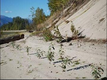
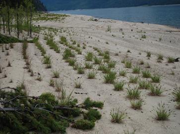
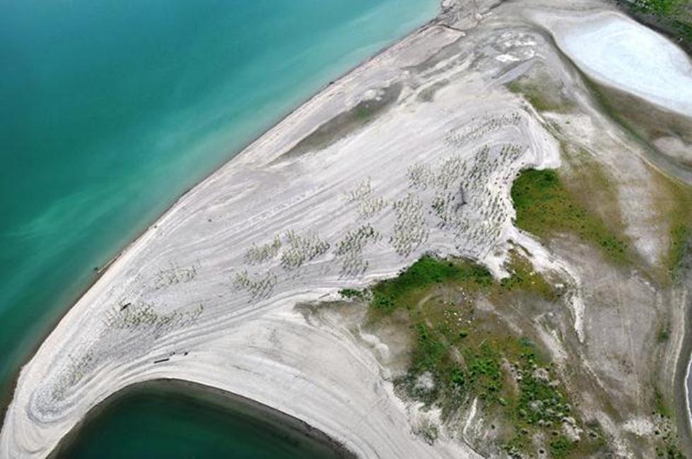
10 REVEGETATION PROGRAM - RESULTS Treated sites from Revelstoke to Renata Sedge plugs, willow & cottonwood plugs; live stakes; fertilization; seeding 108 ha planted; 50 ha fertilized Variable success some areas did great; others did poorly Need further results from monitoring studies to evaluate success overall 10
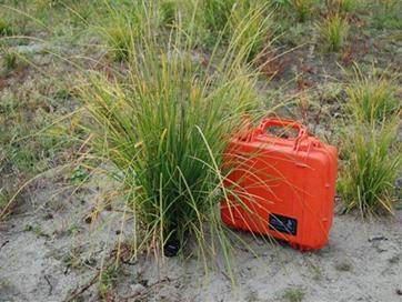
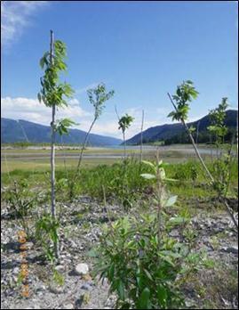
11 REVEGETATION PROGRAM - RESULTS 11

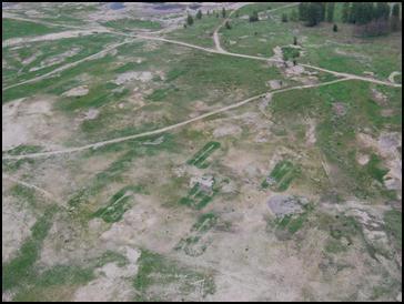
12 MONITORING PROGRAM OBJECTIVES At the landscape level (big picture) Identify and map existing vegetation communities in the drawdown zone How are communities changing over time? Are changes related to soft constraint targets? 12


13 MONITORING PROGRAM OBJECTIVES At the site level (detailed view) Are we losing existing and/or planted species? At what elevations? What conditions affect the success of the revegetation program? Is revegetation more effective than natural vegetation spread? 13
 16")

,")
, climate (temperature &")
 7 thought to be influenced by")


14 MONITORING PROGRAM RESULTS At the landscape level (big picture) 16 vegetation community types were identified in the Arrow Lakes Reservoir Looked at influence of operating regime (inundation), elevation, soils, topography (slope & aspect), climate (temperature & precipitation), and exposure (waves & wind) 7 thought to be influenced by the operating regime 9 others more influenced by other variables BE: Sandy beach BG: Gravelly beach CR: Cottonwood riparian PA: Redtop upland PC: Reed canary grass mesic PE: Horsetail lowland RR: Reed-rill 14


15 MONITORING PROGRAM RESULTS At the landscape level (big picture) Vegetation is being maintained no significant changes in communities between 2008 and 2012 across the reservoir Types and amount of vegetation vary by elevation band Diversity varies with soil type, climate (north to south), and elevation band Reed Canary grass in 2007 Reed Canary grass in 2010 Reed Canary grass in
 Operating regime is one variable of")


16 MONITORING PROGRAM RESULTS At the landscape level (big picture) Operating regime is one variable of many that affects vegetation Observed variation mostly explained by soil type & texture, scouring (from wave action), and temperature during growing season Scouring from wave action Sheltering effect of tree roots 16

17 MONITORING PROGRAM RESULTS At the site level (detailed view) Dominant species are surviving at all elevations lenticular sedge (low elevation), grasses (mid elevation), cottonwood (high elevation) Willow has had high mortality at mid elevation since high fall/winter water levels in 2008/9 Series of lower water years allowed plant expansion into unfavorable habitat Lenticular Sedge Reed Canarygrass Willow 17
, no significant difference in vegetation establishment between control and treatment Planting of")
18 MONITORING PROGRAM RESULTS At the site level (detailed view) Effectiveness of revegetation monitored with control vs. treatment plots Vegetation takes time to establish o As of 2013 (2 years after program completion), no significant difference in vegetation establishment between control and treatment Planting of sedge seedlings has better establishment success than cottonwood live staking Planting site conditions impact success of treatments 18

, operating regime Opportunity to modify operations")

19 MONITORING PROGRAM OBJECTIVES Question for both programs What are key drivers for change in vegetation? o Climate, soil type, water source, exposure (waves & wind), operating regime Opportunity to modify operations to maintain and increase vegetation? o No answer yet; still evaluating influence of operations relative to other factors 19

20 EFFECT OF RESERVOIR OPERATIONS At landscape and site level Operating regime varied more in the fall than in the spring for duration study period ( ) Vegetation reacted negatively to high water period in fall/winter 2008/9 Fall exposure period likely beneficial for flowering plants to set seed and gain biomass before winter dormancy 20


21 CONCLUSIONS The reservoir drawdown zone is a very complex system Many variables influence vegetation in addition to water level fluctuations Operating regime may not be primary influence on vegetation Will need multiple years of data to sort out key drivers of change Repeated high or low water period in fall would provide more clarity on influence of operating regime 21
22 Innonoaklin Road 22
Columbia River Project Water Use Plan
 Columbia River Project Water Use Plan KINBASKET AND ARROW LAKES REVEGETATION MANAGEMENT PLAN Reference: CLBMON-33 Arrow Lakes Reservoir Inventory of Vegetation Resources FINAL REPORT Study Period: 2010,
Use of Bioengineering Techniques for Revegetation of Riparian Areas: Colomac Mine Remediation Project, NWT
 Use of Bioengineering Techniques for Revegetation of Riparian Areas: Colomac Mine Remediation Project, NWT McPherson, M. 1, Vanderspiegel, R. 2, Breadmore, R. 2, and Hewitt, M. 3 2012 RPIC Federal Contaminated
Columbia River Project Water Use Plan
 Columbia River Project Water Use Plan Kinbasket and Arrow Lakes Revegetation Management Plan Implementation Year 5 Reference: CLBMON-33 Arrow Lakes Reservoir Inventory of Vegetation Resources Study Period:
Columbia River Project Water Use Plan. Monitoring Program Terms of Reference HERITAGE MANAGEMENT PLAN
 HERITAGE MANAGEMENT PLAN CLBMON-50 Arrow Lakes Reservoir Heritage Monitoring Wind and Wave Erosion 23 October 2007 1.0 OVERVIEW HERITAGE MANAGEMENT PLAN TERMS OF REFERENCE This document presents Terms
Columbia River Project Water Use Plan
 Columbia River Project Water Use Plan KINBASKET AND ARROW LAKES REVEGETATION MANAGEMENT PLAN Reference: CLBMON-33 Arrow Lakes Reservoir Inventory of Vegetation Resources ADDENDUM TO 2007 FINAL REPORT Study
Natural Shoreline Landscapes on Michigan Inland Lakes
 Natural Shoreline Landscapes on Michigan Inland Lakes Excerpts from Chapters 2 and 3 Photo Photo by Jane by Jane Herbert Herbert Did you know? Twenty-four species of amphibians, 25 species of reptiles,
Review of Riparian Function Riparian Management Riparian Monitoring
 Review of Riparian Function Riparian Management Riparian Monitoring Water Shed Water Catchment Water catching creek Water shedding creek Properly functioning riparian area Properly Functioning Riparian
The role of macrophytes in Ladoga Lake ecosystems
 Russian State Hydrometeorological University Department of Applied Ecology The role of macrophytes in Ladoga Lake ecosystems Dr. Nadezhda Zuyeva Valaam 2010 One of the most important components of the
Dams, sediment, and channel changes and why you should care
 Dams, sediment, and channel changes and why you should care Gordon E. Grant USDA Forest Service PNW Research Station Corvallis, Oregon Dam effects on river regimes FLOW (Q) SEDIMENT (Qs) TEMP CHEMISTRY
Natural Shoreline Landscapes on Michigan Inland Lakes
 Natural Shoreline Landscapes on Michigan Inland Lakes Excerpts from Chapters 2 and 3 Photo Photo by Jane by Jane Herbert Herbert Session topics Characteristics of natural and altered shorelines Lakes,
Wetlands in a Watershed/Landscape Context Vegetation & Wildlife August 15, Kendra Moseley, Regional ESS, Soil Science Division
 Wetlands in a Watershed/Landscape Context Vegetation & Wildlife August 15, 2018 - Kendra Moseley, Regional ESS, Soil Science Division Vegetation in Wetlands Vegetation as an Indicator of Hydrology Vegetation
Ganado Unified School District (Science/Kindergarten)
") 1 st Quarter (July 31 st October 4 th, 2018) 1 st Quarter (8 Performance Objectives) Strand 1: Inquiry Process, Strand 2: History and Nature of Science, Strand 3: Science in Personal and Social Perspectives,
1 st Quarter (July 31 st October 4 th, 2018) 1 st Quarter (8 Performance Objectives) Strand 1: Inquiry Process, Strand 2: History and Nature of Science, Strand 3: Science in Personal and Social Perspectives,
Earth s Major Terrerstrial Biomes. *Wetlands (found all over Earth)
") Biomes Biome: the major types of terrestrial ecosystems determined primarily by climate 2 main factors: Depends on ; proximity to ocean; and air and ocean circulation patterns Similar traits of plants
Biomes Biome: the major types of terrestrial ecosystems determined primarily by climate 2 main factors: Depends on ; proximity to ocean; and air and ocean circulation patterns Similar traits of plants
Island Design. UMRS EMP Regional Workshop. Presentation for the
 Island Design Presentation for the UMRS EMP Regional Workshop by Jon Hendrickson Hydraulic Engineer Regional Technical Specialist, Water Quality and Habitat Restoration August 17 19, 2005 Project Delivery
How Do Human Impacts and Geomorphological Responses Vary with Spatial Scale in the Streams and Rivers of the Illinois Basin?
 How Do Human Impacts and Geomorphological Responses Vary with Spatial Scale in the Streams and Rivers of the Illinois Basin? Bruce Rhoads Department of Geography University of Illinois at Urbana-Champaign
3.7 VISUAL RESOURCES Environmental Setting
 2 3 4 5 6 7 8 9 0 2 3 4 5 6 7 8 9 20 2 22 23 24 25 26 27 28 29 30 3 32 33 34 35 36 37 38 39 40 4 3.7 VISUAL RESOURCES This section assesses the effects of the treatment techniques on views from public
Carmel River Bank Stabilization at Rancho San Carlos Road Project Description and Work Plan March 2018
 Carmel River Bank Stabilization at Rancho San Carlos Road Project Description and Work Plan March 2018 EXISTING CONDITION The proposed Carmel River Bank Stabilization at Rancho San Carlos Road Project
Description DESCRIPTION
 DESCRIPTION The location of the Upper James Watershed is located in northeastern South Dakota as well as southeastern North Dakota. It includes the following counties located in North Dakota Barnes, Dickey,
BEC Correlation Old field guide IDFdk1a 91,92 & 93 BGxh2 06 BGxw 06. Site Characteristics. Soils Black chernozems on morainal blanket.
 Description At PNC this type is dominated by very high cover of rough fescue. It has a few forbs and very few shrubs except in draws and on cooler aspects. Bluebunch wheatgrass is a minor component in
Shoreline and Climate Change Adaptation Alternatives for The Letter Parcel, Bolinas Lagoon
 Shoreline and Climate Change Adaptation Alternatives for The Letter Parcel, Bolinas Lagoon Scenic shoreline vista of Bolinas Lagoon and ridges, from Letter Parcel, March 2016 Peter Baye, Coastal Ecologist
Chapter 6. Field Trip to Sandia Mountains.
 University of New Mexico Biology 310L Principles of Ecology Lab Manual Page -40 Chapter 6. Field Trip to Sandia Mountains. Outline of activities: 1. Travel to Sandia Mountains 2. Collect forest community
RANGE AND ANIMAL SCIENCES AND RESOURCES MANAGEMENT - Vol. II - Catchment Management A Framework for Managing Rangelands - Hugh Milner
 CATCHMENT MANAGEMENT A FRAMEWORK FOR MANAGING RANGELANDS Hugh Milner International Water Management Consultant, Australia Keywords: Rangeland management; catchments and watersheds; catchment management
Appendix J Vegetation Change Analysis Methodology
 Appendix J Vegetation Change Analysis Methodology Regional Groundwater Storage and Recovery Project Draft EIR Appendix-J April 2013 APPENDIX J- LAKE MERCED VEGETATION CHANGE ANALYSIS METHODOLOGY Building
3.3 CLIMATE, GEOLOGY, TOPOGRAPHY, AND SOILS CLIMATE GEOLOGY TOPOGRAPHY
 3.3 CLIMATE, GEOLOGY, TOPOGRAPHY, AND SOILS This section describes the climate, geology, topography, and soil resource characteristics of the Yolo Bypass Wildlife Area (Wildlife Area). Agricultural soil
LANDSCAPE CHANGE IN THE SOUTHWEST: Historical changes in selected ecosystems of the southwestern United States
 LANDSCAPE CHANGE IN THE SOUTHWEST: Historical changes in selected ecosystems of the southwestern United States Robert H. Webb U.S. Geological Survey 520 N. Park Avenue Tucson, AZ 85719 rhwebb@usgs.gov
It is relatively simple to comprehend the characteristics and effects of an individual id fire. However, it is much more difficult to do the same for
 Interactive Effects of Plant Invasions and Fire in the Hot Deserts of North America Matt Brooks U.S. Geological Survey Western Ecological Research Center Yosemite Field Station, El Portal CA Presentation
Tenmile Lakes Delta Building Study
 Tenmile Lakes Delta Building Study Since the late 1940 s, Tenmile Lakes has seen a sharp increase in sediment accumulation at the mouths of the tributaries that feed the lake. To monitor this sediment
Briggs Lake Water Quality Report 2014
 Briggs Lake Water Quality Report 2014 Seasonal Report for Briggs Lake Green Oak Township, Livingston Co. T1N, R6E, Sec. 3,4 74 Surface Acres 414 Hadley Street Holly, MI 48442 Main Phone: 248-634-8388 Northern
Instream Erosion Control General
 Instream Erosion Control General EROSION CONTROL TECHNIQUES Revegetation Temperate Climates Short-Term Non Vegetation Wet Tropics Long-Term Weed Control [1] Semi-Arid Zones Permanent [1] Weed control attributes
The Ordinary High Water Mark: Concepts, Research, and Applications. Matthew K. Mersel March 20, 2013
 The Ordinary High Water Mark: Concepts, Research, and Applications Matthew K. Mersel March 20, 2013 Under Section 404 of the Clean Water Act, the OHWM defines the lateral limits of Federal jurisdiction
Wisconsin River Floodplain Project: Overview and Plot Metadata
 Wisconsin River Floodplain Project: Overview and Plot Metadata CLASS I. DATA SET DESCRIPTORS Data set identity: Plot-level variable information for Wisconsin River Floodplain Project. Relevant for following
Environmental Science: Biomes Test
 Name: Date: Pd. VERSION 1 Environmental Science: Biomes Test 1. Eland are large herbivores with loose skin under the throat and neck. This patch of skin aids in lowering the body temperature when temperatures
Ecological Land Cover Classification For a Natural Resources Inventory in the Kansas City Region, USA
 Ecological Land Cover Classification For a Natural Resources Inventory in the Kansas City Region, USA by Applied Ecological Services, Inc. In cooperation with the Mid-America Regional Council 600 Broadway,
Data Dictionary for Network of Conservation Areas Transcription Reports from the Colorado Natural Heritage Program
 Data Dictionary for Network of Conservation Areas Transcription Reports from the Colorado Natural Heritage Program This Data Dictionary defines terms used in Network of Conservation Areas (NCA) Reports
MEMORANDUM FOR SWG
 MEMORANDUM FOR SWG-2007-1623 Subject: Jurisdictional Determination (JD) for SWG-2007-1623 on Interdunal Wetlands Adjacent to Traditional Navigable Waters (TNWs) Summary The U.S. Environmental Protection
BEC Correlation BGxh2 01, 02, 05, 06. Site Characteristics
 Description This type is dominated by bluebunch wheatgrass, Sandberg s bluegrass, and sagebrush with low cover of mixed forbs and moderate cover of biological crusts. Production and total plant cover is
Local Climate Change Impacts for Central Illinois
 Local Climate Change Impacts for Central Illinois Molly Woloszyn Extension Climatologist Midwestern Regional Climate Center & Illinois-Indiana Sea Grant Urbana Sustainability Advisory Commission February
The Invasion of False Brome in Western Oregon
 The Invasion of False Brome in Western Oregon GIS II Presentation Winter 2006 Will Fellers Kurt Hellerman Kathy Strope Statia Cupit False Brome (Brachypodium sylvaticum) Perennial bunchgrass native to
Evaluating Wildlife Habitats
 Lesson C5 4 Evaluating Wildlife Habitats Unit C. Animal Wildlife Management Problem Area 5. Game Animals Management Lesson 4. Evaluating Wildlife Habitats New Mexico Content Standard: Pathway Strand: Natural
Influence of the Major Drainages to the Mississippi River and Implications for System Level Management
 Influence of the Major Drainages to the Mississippi River and Implications for System Level Management Brian M. Vosburg Geologist Louisiana Coastal Protection and Restoration Authority brian.vosburg@la.gov
Assisted colonization of native forbs the use of climate-adjusted provenances. Sue McIntyre
 Assisted colonization of native forbs the use of climate-adjusted provenances Sue McIntyre Why move grassland forbs? Grassland forbs need help populations are depleted and fragmented. Climate change likely
Stabilization Study. Prepared For: The Town of Bethlehem. Henry Hudson Park Shoreline Stabilization Study. June 2011
 Henry Hudson Park Shoreline Stabilization Study Prepared For: The Town of Bethlehem 1 Company Introduction - OCC Ocean and Coastal Consultants (OCC) is a 50 person engineering consulting firm that specializes
3.0 TECHNICAL FEASIBILITY
 3.0 TECHNICAL FEASIBILITY 3.1 INTRODUCTION To enable seasonal storage and release of water from Lake Wenatchee, an impoundment structure would need to be constructed on the lake outlet channel. The structure
15 Non-Native Plants at Lake Mead National Recreation Area
 15 Non-Native Plants at Lake Mead National Recreation Area To report weed locations use non-native plant survey form and/or contact: Carrie Norman Exotic Plant Manager carrie_norman@nps.gov 702-293-8734
Monitoring Program Terms of Reference HERITAGE AND CULTURE INFORMATION PLAN
 Monitoring Program Terms of Reference HERITAGE AND CULTURE INFORMATION PLAN GMSMON-21a Peace - Archaeological Overview Assessment May 2, 2008 1.0 OVERVIEW HERITAGE AND CULTURE INFORMATION PLAN TERMS OF
Biodiversity Blueprint Overview
 Biodiversity Blueprint Overview Climate Variability Climate projections for the Glenelg Hopkins Regions suggest that the weather will be hotter and drier in the coming years which will impact on land use,
Learning Objectives: I can identify and interpret river flows and directions.
 Learning Objectives: I can identify and interpret river flows and directions. Bellringer Review: Check for Understanding Questions: 1 2 What Are The Key Parts Of A River s Anatomy? In your data notebooks
EAGLES NEST AND PIASA ISLANDS
 EAGLES NEST AND PIASA ISLANDS HABITAT REHABILITATION AND ENHANCEMENT PROJECT MADISON AND JERSEY COUNTIES, ILLINOIS ENVIRONMENTAL MANAGEMENT PROGRAM ST. LOUIS DISTRICT FACT SHEET I. LOCATION The proposed
Lesson 9: California Ecosystem and Geography
 California Education Standards: Kindergarten, Earth Sciences 3. Earth is composed of land air, and water. As a basis for understanding this concept: b. Students know changes in weather occur from day to
Appendix D ORV Assessment for Clarion River
 Introduction The following ORV assessment criteria were utilized in making WSR eligibility determinations for the 2007 ANF LRMP. These criteria will also be used to assess resource values for the Clarion
Sprague River Basin Restoration Post Project Evaluations: Lessons Learned and Future Applications
 River Restoration Northwest, 2015 Sprague River Basin Restoration Post Project Evaluations: Lessons Learned and Future Applications Mark R. Tompkins, P.E., Ph.D. ACKNOWLEDGEMENTS The Klamath Tribes Larry
Third Annual Monitoring Report Tidal Wetland Restoration 159 Long Neck Point Road, Darien, CT NAE
 1) Project Overview Third Annual Monitoring Report Tidal Wetland Restoration 159 Long Neck Point Road, Darien, CT NAE-2007-1130 December 15, 2014 This is the third year of a five year monitoring program
ADDRESSING GEOMORPHIC AND HYDRAULIC CONTROLS IN OFF-CHANNEL HABITAT DESIGN
 ADDRESSING GEOMORPHIC AND HYDRAULIC CONTROLS IN OFF-CHANNEL HABITAT DESIGN Conor Shea - Hydrologist U.S. Fish and Wildlife Service Conservation Partnerships Program Arcata, CA Learning Objectives Examine
Decline of Lake Michigan-Huron Levels Caused by Erosion of the St. Clair River
 Decline of Lake Michigan-Huron Levels Caused by Erosion of the St. Clair River W.F. & Associates Coastal Engineers (in association with Frank Quinn) April 13, 2005 Outline Problem Definition Understanding
Thompson Nicola Fraser Middle Grasslands
 Description This type occurs as a transition between the lower grassland and the upper grasslands. At PNC it is dominated by a combination of Bluebunch wheatgrass and rough fescue in all areas and with
GENERAL INFORMATION From British Colombia south to California, west into Idaho and south of Sierra Nevada. (2,3,7)
") Plant Propagation Protocol for Cephalanthera austiniae ESRM 412 Native Plant Production Spring 2008 Family Names Family Scientific Name: Family Common Name: Scientific Names Genus: Species: Species Authority:
Plant Propagation Protocol for Cephalanthera austiniae ESRM 412 Native Plant Production Spring 2008 Family Names Family Scientific Name: Family Common Name: Scientific Names Genus: Species: Species Authority:
Sustainable Methods for Reducing Shoreline Erosion
 Sustainable Methods for Reducing Shoreline Erosion Chris Randall Master s Student Natural Resources Institute University of Manitoba Disclaimer For advise on specific problems relating to erosion and bank
Alamito Creek Preserve Ranches for Sale Marfa, Presidio County, Texas
 Alamito Creek Preserve Ranches for Sale Marfa, Presidio County, Texas James King, Agent Office 432 426.2024 Cell 432 386.2821 James@KingLandWater.com Alamito Creek Preserve Various size Ranch Properties,
Lecture 24 Plant Ecology
 Lecture 24 Plant Ecology Understanding the spatial pattern of plant diversity Ecology: interaction of organisms with their physical environment and with one another 1 Such interactions occur on multiple
Project (Project No. US-CA-62-2) Maintenance Inspection and Reports (Subtask 14.1) Inspection Report No.2
 Maintenance Inspection and Reports (Subtask 14.1) Inspection Report No.2") MEMORANDUM TO: FROM: Jim Well, Ducks Unlimited Mike Harvey, PhD, PG SUBJECT: M&T/ Llano Seco Fish Screen Project (Project No. US-CA-62-2) Maintenance Inspection and Reports (Subtask 14.1) Inspection Report
MEMORANDUM TO: FROM: Jim Well, Ducks Unlimited Mike Harvey, PhD, PG SUBJECT: M&T/ Llano Seco Fish Screen Project (Project No. US-CA-62-2) Maintenance Inspection and Reports (Subtask 14.1) Inspection Report
Climate Change Scenario Planning: A Tool for Managing Resources in an Era of Uncertainty
 Climate Change Scenario Planning: A Tool for Managing Resources in an Era of Uncertainty Leigh Welling Climate Change Coordinator National Park Service Natural Resource Stewardship & Science Mount Rainier
TSEGI WASH 50% DESIGN REPORT
 TSEGI WASH 50% DESIGN REPORT 2/28/2014 Daniel Larson, Leticia Delgado, Jessica Carnes I Table of Contents Acknowledgements... IV 1.0 Project Description... 1 1.1 Purpose... 1 Figure 1. Erosion of a Headcut...
FOSS California Structures of Life Module Glossary 2007 Edition
 FOSS California Structures of Life Module Glossary 2007 Edition Adaptation: Any structure or behavior of an organism that improves its chances for survival. Adult: A fully-grown organism. The last stage
Plant responses to climate change in the Negev
 Ben-Gurion University of the Negev Plant responses to climate change in the Negev 300 200 150? Dr. Bertrand Boeken Dry Rangeland Ecology and Management Lab The Wyler Dept. of Dryland Agriculture Jacob
Vegetation effects on river hydraulics. Johannes J. (Joe) DeVries David Ford Consulting Engineers, Inc. Sacramento, CA
 DeVries David Ford Consulting Engineers, Inc. Sacramento, CA") Vegetation effects on river hydraulics Johannes J. (Joe) DeVries David Ford Consulting Engineers, Inc. Sacramento, CA jjdevries@ford-consulting.com SAC05 D2P31 RM 99.0L VIEW UPSTREAM AT UPSTREAM END DWR
Vegetation effects on river hydraulics Johannes J. (Joe) DeVries David Ford Consulting Engineers, Inc. Sacramento, CA jjdevries@ford-consulting.com SAC05 D2P31 RM 99.0L VIEW UPSTREAM AT UPSTREAM END DWR
WATER LEVEL REGIMES CLIMATE CHANGE SCENARIOS TRANSITIONAL HABITATS AND REFUGIA
 WATER LEVEL REGIMES CLIMATE CHANGE SCENARIOS TRANSITIONAL HABITATS AND REFUGIA Scudder D. Mackey University of Windsor/Habitat Solutions Funded by the Great Lakes Fishery Commission USFWS Restoration Act
MESLEKİ İNGİLİZCE I. Doç. Dr. Hakan OĞUZ. Kahramanmaraş Sütçü İmam Üniver sitesi. Peyzaj Mimarlığı Bölümü
 MESLEKİ İNGİLİZCE I Doç. Dr. Hakan OĞUZ Kahramanmaraş Sütçü İmam Üniver sitesi Orman Fakültesi Peyzaj Mimarlığı Bölümü 1 dump station A place provided for recreational vehicles, camp trailers, etc. with
Chapter 3. Description of the Study Area. Karl Taboga, James Stafford and Paul Taucher 3-19
 Chapter 3 Description of the Study Area Karl Taboga, James Stafford and Paul Taucher 3-19 T his study examines groundwater resources that underlie the Bear River drainage basin in Wyoming as well as areas
Ecology Student Edition. A. Sparrows breathe air. B. Sparrows drink water. C. Sparrows use the sun for food. D. Sparrows use plants for shelter.
 Name: Date: 1. Which of the following does not give an example of how sparrows use resources in their environment to survive? A. Sparrows breathe air. B. Sparrows drink water. C. Sparrows use the sun for
II. Resource benefits. Å. Native Fish
 Discussion Points for a Sediment-Triggered BHBF Test in WY07, New Information and Need for Reconsideration and Recommendation to the Secretary of the Interior 11/30/07 FINAL Proposed AMWG motion for Dec.
Sediment Management in the Coastal Bays
 Sediment Management in the Coastal Bays Introduction Need for ecosystem view of sediment management in Coastal Bays Island loss and restoration Navigation needs Habitat Trade offs Living Shoreline Requirements
use limited written language, spoken language, numbers, or labeled drawings to describe observed objects and phenomena. (N.2.A.1)
") N.2.A.1 Students know how to make observations and give descriptions using words, numbers, and drawings. Science Achievement Indicators Grade Span Content Standard N2A Students understand that science
N.2.A.1 Students know how to make observations and give descriptions using words, numbers, and drawings. Science Achievement Indicators Grade Span Content Standard N2A Students understand that science
Studies on adaptation capacity of Carpathian ecosystems/landscape to climate change
 ` Studies on adaptation capacity of Carpathian ecosystems/landscape to climate change Science for the Carpathians CARPATHIAN CONVENTION COP5 Lillafüred, 10.10.2017-12.10.2017 Marcel Mîndrescu, Anita Bokwa
Chapter 7 Part III: Biomes
 Chapter 7 Part III: Biomes Biomes Biome: the major types of terrestrial ecosystems determined primarily by climate 2 main factors: Temperature and precipitation Depends on latitude or altitude; proximity
Georgia Performance Standards for Urban Watch Restoration Field Trips
 Georgia Performance Standards for Field Trips 6 th grade S6E3. Students will recognize the significant role of water in earth processes. a. Explain that a large portion of the Earth s surface is water,
Cannon River Watershed 2017 Zonation Update Clarification
 Project Name Cannon River One Watershed, One Plan Date 8-10-2017 To / Contact info Policy Committee Planning Work Group From / Contact info Regarding Meghan Funke, PhD Cannon River Watershed 2017 Zonation
LIFE HISTORY STRATEGIES
 LIFE HISTORY STRATEGIES LIFE HISTORY STRATEGIES What characteristics help a population survive and grow? What are the dominant species in an ecosystem? Why doesn't a dominant species (of plant or animal)
Stream Restoration and Environmental River Mechanics. Objectives. Pierre Y. Julien. 1. Peligre Dam in Haiti (deforestation)
") Stream Restoration and Environmental River Mechanics Pierre Y. Julien Malaysia 2004 Objectives Brief overview of environmental river mechanics and stream restoration: 1. Typical problems in environmental
Stream Restoration and Environmental River Mechanics Pierre Y. Julien Malaysia 2004 Objectives Brief overview of environmental river mechanics and stream restoration: 1. Typical problems in environmental
REVEGETATION TRENDS AND LESSONS MONTANA COAL
 REVEGETATION TRENDS AND LESSONS MONTANA COAL The secret of managing is to keep the guys who hate you away from the guys who are undecided. Casey Stengel Can't anybody here play this game? Casey Stengel
1:30 2:00 Tangible Examples of NVC Uses from Monitoring, Mapping, and Habitat Modeling. (Todd Keeler- Wolf, ESA Panel)
") 1:30 2:00 Tangible Examples of NVC Uses from Monitoring, Mapping, and Habitat Modeling. (Todd Keeler- Wolf, ESA Panel) Habitat Modeling for Mojave Ground Squirrel: a rare species of the Western Mojave
1:30 2:00 Tangible Examples of NVC Uses from Monitoring, Mapping, and Habitat Modeling. (Todd Keeler- Wolf, ESA Panel) Habitat Modeling for Mojave Ground Squirrel: a rare species of the Western Mojave
Catastrophic Events Impact on Ecosystems
 Catastrophic Events Impact on Ecosystems Hurricanes Hurricanes An intense, rotating oceanic weather system with sustained winds of at least 74 mph and a welldefined eye Conditions for formation: Warm water
Adaptive Radiation (Lexile 990L)
") daptation daptive Radiation (Lexile 990L) 1 The Hawaiian Islands are the picture of a tropical paradise. There are beaches, mountains, rainforests, grasslands, and deserts to explore, often on a single
daptation daptive Radiation (Lexile 990L) 1 The Hawaiian Islands are the picture of a tropical paradise. There are beaches, mountains, rainforests, grasslands, and deserts to explore, often on a single
TUNDRA. Column 1 biome name Column 2 biome description Column 3 examples of plant adaptations
 Biome Cards (pp. 1 of 7) Cut out each biome card and divide each card into three sections. Place all sections in a plastic storage bag. Have one bag for every two students. Column 1 biome name Column 2
Changes in Texas Ecoregions
 Comment On Lesson Changes in Texas Ecoregions The state of Texas can be divided into 10 distinct areas based on unique combinations of vegetation, topography, landforms, wildlife, soil, rock, climate,
East Branch Grand Calumet River Great Lakes Legacy Act Sediment Remediation and Restoration Project
 East Branch Grand Calumet River Great Lakes Legacy Act Sediment Remediation and Restoration Project Jointly funded by the U.S. EPA Great Lakes Legacy Act, Indiana Department of Environmental Management
Biomes Section 1. Chapter 6: Biomes Section 1: What is a Biome? DAY ONE
 Chapter 6: Biomes Section 1: What is a Biome? DAY ONE What is a Biome? Biomes are large regions characterized by a specific type of climate and certain types of plant and animal communities. The climate
Description This type exists as two distinct communities:
 Description This type exists as two distinct communities: A) Bluebunch wheatgrass -- big sage This community is dominated by bluebunch wheatgrass with a low (5-10%) cover of big sage brush. The big sage
Ecology for Planting Design - understanding long-term plant performance. (C) Noel Kingsbury 2016
 Noel Kingsbury 2016") Ecology for Planting Design - understanding long-term plant performance (C) Noel Kingsbury 2016 Understanding plants as living materials Inherently less predictable than hard materials Need to understand,
Ecology for Planting Design - understanding long-term plant performance (C) Noel Kingsbury 2016 Understanding plants as living materials Inherently less predictable than hard materials Need to understand,
Chris Lenhart, John Nieber, Ann Lewandowski, Jason Ulrich TOOLS AND STRATEGIES FOR REDUCING CHANNEL EROSION IN MINNESOTA
 Chris Lenhart, John Nieber, Ann Lewandowski, Jason Ulrich TOOLS AND STRATEGIES FOR REDUCING CHANNEL EROSION IN MINNESOTA Background and approach Channel loading major source of sediment in much of MN River
Assessing Michigan s Biological diversity. Michigan Natural Features Inventory MSU Extension
 Assessing Michigan s Biological diversity John Paskus,, Amy Derosier,, Edward Schools, and Helen Enander Michigan Natural Features Inventory MSU Extension Goal Provide scientifically based information
DESCHUTES RIVER BANK STABILIZATION PROJECTS ASSESSMENT
 DESCHUTES RIVER BANK STABILIZATION PROJECTS ASSESSMENT Prepared for: Deschutes River Conservancy 700 NW Hill Street Bend, Oregon 97701 Prepared by: River Design Group, Inc. 6029 SW 33 rd Place Portland,
Which map shows the stream drainage pattern that most likely formed on the surface of this volcano? A) B)
 B)") 1. When snow cover on the land melts, the water will most likely become surface runoff if the land surface is A) frozen B) porous C) grass covered D) unconsolidated gravel Base your answers to questions
1. When snow cover on the land melts, the water will most likely become surface runoff if the land surface is A) frozen B) porous C) grass covered D) unconsolidated gravel Base your answers to questions
DETAILED DESCRIPTION OF STREAM CONDITIONS AND HABITAT TYPES IN REACH 4, REACH 5 AND REACH 6.
 DETAILED DESCRIPTION OF STREAM CONDITIONS AND HABITAT TYPES IN REACH 4, REACH 5 AND REACH 6. The Eklutna River was divided into study reaches (figure 1) prior to this site visit. Prominent geologic or
Virginia Shoreline Mapping Tools
 Virginia Shoreline Mapping Tools December 15, 2017 Karen Duhring Center for Coastal Resources Management Virginia Institute of Marine Science College of William & Mary Virginia Shoreline Mapping Tools
GLYPHOSATE, IMAZAPYR AND?? HERBICIDES FOR GRASS CONTROL - Greg MacDonald Agronomy Dept. University of Florida
 GLYPHOSATE, IMAZAPYR AND?? HERBICIDES FOR GRASS CONTROL - Greg MacDonald Agronomy Dept. University of Florida TYPES OF GRASSES Perennial or Annual Bunch or Spreading Stolons or Rhizomes Viable Seeds or
Organism Species Population Community Ecosystem
 Name: Date: Period: Ecosystems and Their Interactions S8.B.3.1 Getting the idea The environment is everything that surrounds an organism. Organisms cooperate and compete with each other to get everything
Assessing state-wide biodiversity in the Florida Gap analysis project
 University of Nebraska - Lincoln DigitalCommons@University of Nebraska - Lincoln Nebraska Cooperative Fish & Wildlife Research Unit -- Staff Publications Nebraska Cooperative Fish & Wildlife Research Unit
Environmental Science
 Environmental Science A Study of Interrelationships Cui Jiansheng Hebei University of Science and Technology CH06 Kinds of Ecosystems and Communities Chapter Objectives After reading this chapter, you
UNIT 4. ECOSYSTEMS ACTIVITIES
 UNIT 4. ECOSYSTEMS ACTIVITIES Tania Ostolaza Fernández sharpandsavvy.es CHECK YOUR LEARNING Answer the following questions. Use full sentences and be careful with your handwriting. ELEMENTS OF AN ECOSYSTEM
E XTREME D ROUGHT An oppressive, long-term
 E XTREME D ROUGHT 2006-2008 An oppressive, long-term drought lasting from late March of 2006 until late August of 2008 impacted the entire state of Florida, with costly consequences in residential water