APPROVED JURISDICTIONAL DETERMINATION FORM U.S. Army Corps of Engineers
|
|
|
- Willis Edwards
- 5 years ago
- Views:
Transcription
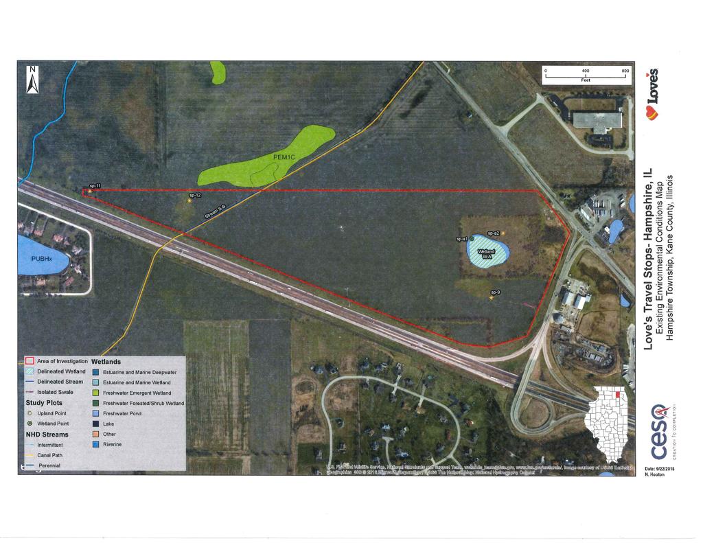
1 APPROVED JURISDICTIONAL DETERMINATION FORM U.S. Army Corps of Engineers SECTION I: BACKGROUND INFORMATION A. REPORT COMPLETION DATE FOR APPROVED JURISDICTIONAL DETERMINATION (JD): November 3, 06 B. DISTRICT OFFICE, FILE NAME, AND NUMBER: Chicago District, Love's Truck Stop, LRC C. PROJECT LOCATION AND BACKGROUND INFORMATION: NW of I-90 and Route 0 State: Illinois County/parish/borough: Kane City: Hampshire Center coordinates of site (lat/long in degree decimal format): Lat N, Long W. Universal Transverse Mercator: Zone 6 Name of nearest waterbody: Harmony Creek Name of nearest Traditional Navigable Water (TNW) into which the aquatic resource flows: Rock River Name of watershed or Hydrologic Unit Code (HUC): Kishwaukee ( ) Check if map/diagram of review area and/or potential jurisdictional areas is/are available upon request. Check if other sites (e.g., offsite mitigation sites, disposal sites, etc ) are associated with this action and are recorded on a different JD form. D. REVIEW PERFORMED FOR SITE EVALUATION (CHECK ALL THAT APPLY): Office (Desk) Determination. Date: October, 06 Field Determination. Date(s): October 7, 06 SECTION II: SUMMARY OF FINDINGS A. RHA SECTION 0 DETERMINATION OF JURISDICTION. There Are no navigable waters of the U.S. within Rivers and Harbors Act (RHA) jurisdiction (as defined by 33 CFR part 39) in the review area. [Required] Waters subject to the ebb and flow of the tide. Waters are presently used, or have been used in the past, or may be susceptible for use to transport interstate or foreign commerce. Explain: Defined in People of State of Ill. ex rel. Scott v. Hoffman, No. P-CIV-76-45, slip op. at 7 (S.D.Ill. Jan. 0, 979). B. CWA SECTION 404 DETERMINATION OF JURISDICTION. There Are waters of the U.S. within Clean Water Act (CWA) jurisdiction (as defined by 33 CFR part 38) in the review area. [Required]. Waters of the U.S. a. Indicate presence of waters of U.S. in review area (check all that apply): TNWs, including territorial seas Wetlands adjacent to TNWs Relatively permanent waters (RPWs) that flow directly or indirectly into TNWs Wetlands directly abutting RPWs that flow directly or indirectly into TNWs b. Identify (estimate) size of waters of the U.S. in the review area: Non-wetland waters: 000 linear feet: 0 width (ft) and/or acres. c. Limits (boundaries) of jurisdiction based on: Established by OHWM. Elevation of established OHWM (if known):. SECTION III: CWA ANALYSIS A. TNWs AND WETLANDS ADJACENT TO TNWs The agencies will assert jurisdiction over TNWs and wetlands adjacent to TNWs. If the aquatic resource is a TNW, complete Section III.A. and Section III.D.. only; if the aquatic resource is a wetland adjacent to a TNW, complete Sections III.A. and and Section III.D..; otherwise, see Section III.B below.. TNW Identify TNW: Pick List. Summarize rationale supporting determination: As defined in People of State of Ill. ex rel. Scott v. Hoffman, No. P-CIV-76-45, slip op. at 7 (S.D.Ill. Jan. 0, 979).. Wetland adjacent to TNW Summarize rationale supporting conclusion that wetland is adjacent :. Boxes checked below shall be supported by completing the appropriate sections in Section III below. For purposes of this form, an RPW is defined as a tributary that is not a TNW and that typically flows year-round or has continuous flow at least seasonally (e.g., typically 3 months).
2 D. DETERMINATIONS OF JURISDICTIONAL FINDINGS. THE SUBJECT WATERS/WETLANDS ARE (CHECK ALL THAT APPLY):. TNWs and Adjacent Wetlands. Check all that apply and provide size estimates in review area: TNWs: linear feet width (ft), Or, acres. Wetlands adjacent to TNWs: acres.. RPWs that flow directly or indirectly into TNWs. Tributaries of TNWs where tributaries typically flow year-round are jurisdictional. Provide data and rationale indicating that tributary is perennial: Tributary is mapped as a blue-line stream on USGS maps. Tributaries of TNW where tributaries have continuous flow seasonally (e.g., typically three months each year) are jurisdictional. Data supporting this conclusion is provided at Section III.B. Provide rationale indicating that tributary flows seasonally:. Provide estimates for jurisdictional waters in the review area (check all that apply): Tributary waters: linear feet width (ft). Other non-wetland waters: acres. Identify type(s) of waters:. 4. Wetlands directly abutting an RPW that flow directly or indirectly into TNWs. Wetlands directly abut RPW and thus are jurisdictional as adjacent wetlands. Wetlands directly abutting an RPW where tributaries typically flow year-round. Provide data and rationale indicating that tributary is perennial in Section III.D., above. Provide rationale indicating that wetland is directly abutting an RPW:. Wetlands directly abutting an RPW where tributaries typically flow seasonally. Provide data indicating that tributary is seasonal in Section III.B and rationale in Section III.D., above. Provide rationale indicating that wetland is directly abutting an RPW:. Provide acreage estimates for jurisdictional wetlands in the review area: acres. SECTION IV: DATA SOURCES. A. SUPPORTING DATA. Data reviewed for JD (check all that apply - checked items shall be included in case file and, where checked and requested, appropriately reference sources below): Maps, plans, plots or plat submitted by or on behalf of the applicant/consultant: Ceso, Inc. Regulated Waters Delineation Report dated September 7, 06. Data sheets prepared/submitted by or on behalf of the applicant/consultant. Office concurs with data sheets/delineation report. Office does not concur with data sheets/delineation report. Data sheets prepared by the Corps:. Corps navigable waters study:. U.S. Geological Survey Hydrologic Atlas:Marengo South HA 463, 97,. USGS NHD data. USGS 8 and digit HUC maps. U.S. Geological Survey map(s). Cite scale & quad name: Marengo South 7.5", 968, Pick List, Pick List,. USDA Natural Resources Conservation Service Soil Survey. Citation: Soil Survey of Kane County, Illinois (003). National wetlands inventory map(s). Cite name: Marengo South,. State/Local wetland inventory map(s): Kane County ADID, Pick List,. FEMA/FIRM maps:. 00-year Floodplain Elevation is: (National Geodetic Vertical Datum of 99) Photographs: Aerial (Name & Date):. or Other (Name & Date):. Previous determination(s). File no. and date of response letter:. Applicable/supporting case law: People of State of Ill. ex rel. Scott v. Hoffman, No. P-CIV-76-45, (S.D.Ill. Jan. 0, 979) Applicable/supporting scientific literature:. Other information (please specify):. B. ADDITIONAL COMMENTS TO SUPPORT JD: Site visit on October 7, 06 to view water in channel.
3 APPROVED JURISDICTIONAL DETERMINATION FORM U.S. Army Corps of Engineers This form should be completed by following the instructions provided in Section IV of the JD Form Instructional Guidebook. SECTION I: BACKGROUND INFORMATION A. REPORT COMPLETION DATE FOR APPROVED JURISDICTIONAL DETERMINATION (JD): November 3, 06 B. DISTRICT OFFICE, FILE NAME, AND NUMBER: Chicago District, Love's Truck Stop, LRC C. PROJECT LOCATION AND BACKGROUND INFORMATION: NW of I-90 & Rt. 0 State: Illinois County/parish/borough: Kane City: Hampshire Center coordinates of site (lat/long in degree decimal format): Lat N, Long W. Universal Transverse Mercator: Zone 6 Name of nearest waterbody: Harmony Creek Name of nearest Traditional Navigable Water (TNW) into which the aquatic resource flows: Rock River Name of watershed or Hydrologic Unit Code (HUC): Kishwaukee ( ) Check if map/diagram of review area and/or potential jurisdictional areas is/are available upon request. Check if other sites (e.g., offsite mitigation sites, disposal sites, etc ) are associated with this action and are recorded on a different JD form. D. REVIEW PERFORMED FOR SITE EVALUATION (CHECK ALL THAT APPLY): Office (Desk) Determination. Date: October, 06 Field Determination. Date(s): October 7, 06 SECTION II: SUMMARY OF FINDINGS A. RHA SECTION 0 DETERMINATION OF JURISDICTION. There Are no navigable waters of the U.S. within Rivers and Harbors Act (RHA) jurisdiction (as defined by 33 CFR part 39) in the review area. [Required] B. CWA SECTION 404 DETERMINATION OF JURISDICTION. There Are no waters of the U.S. within Clean Water Act (CWA) jurisdiction (as defined by 33 CFR part 38) in the review area. [Required]. Non-regulated waters/wetlands (check if applicable): Potentially jurisdictional waters and/or wetlands were assessed within the review area and determined to be not jurisdictional. Explain: The subject wetland is a closed isolated bowl-shaped depressional wetland with no outlet. SECTION III: CWA ANALYSIS E. ISOLATED [INTERSTATE OR INTRA-STATE] WATERS, INCLUDING ISOLATED WETLANDS, THE USE, DEGRADATION OR DESTRUCTION OF WHICH COULD AFFECT INTERSTATE COMMERCE, INCLUDING ANY SUCH WATERS (CHECK ALL THAT APPLY): which are or could be used by interstate or foreign travelers for recreational or other purposes. from which fish or shellfish are or could be taken and sold in interstate or foreign commerce. which are or could be used for industrial purposes by industries in interstate commerce. Interstate isolated waters. Explain:. Other factors. Explain:. Identify water body and summarize rationale supporting determination:. Provide estimates for jurisdictional waters in the review area (check all that apply): Tributary waters: linear feet width (ft). Other non-wetland waters: acres. Identify type(s) of waters:. Supporting documentation is presented in Section III.F. Prior to asserting or declining CWA jurisdiction based solely on this category, Corps Districts will elevate the action to Corps and EPA HQ for review consistent with the process described in the Corps/EPA Memorandum Regarding CWA Act Jurisdiction Following Rapanos.
4 F. NON-JURISDICTIONAL WATERS, INCLUDING WETLANDS (CHECK ALL THAT APPLY): If potential wetlands were assessed within the review area, these areas did not meet the criteria in the 987 Corps of Engineers Wetland Delineation Manual and/or appropriate Regional Supplements. Review area included isolated waters with no substantial nexus to interstate (or foreign) commerce. Prior to the Jan 00 Supreme Court decision in SWANCC, the review area would have been regulated based solely on the Migratory Bird Rule (MBR). Waters do not meet the Significant Nexus standard, where such a finding is required for jurisdiction. Explain:. Other: (explain, if not covered above):. Provide acreage estimates for non-jurisdictional waters in the review area, where the sole potential basis of jurisdiction is the MBR factors (i.e., presence of migratory birds, presence of endangered species, use of water for irrigated agriculture), using best professional judgment (check all that apply): Non-wetland waters (i.e., rivers, streams): linear feet width (ft). Lakes/ponds: acres. Other non-wetland waters: acres. List type of aquatic resource:. Wetlands:.83 acres. Provide acreage estimates for non-jurisdictional waters in the review area that do not meet the Significant Nexus standard, where such a finding is required for jurisdiction (check all that apply): Non-wetland waters (i.e., rivers, streams): linear feet, width (ft). Lakes/ponds: acres. Other non-wetland waters: acres. List type of aquatic resource:. SECTION IV: DATA SOURCES. A. SUPPORTING DATA. Data reviewed for JD (check all that apply - checked items shall be included in case file and, where checked and requested, appropriately reference sources below): Maps, plans, plots or plat submitted by or on behalf of the applicant/consultant: Ceso, Inc. Regulated Waters Delineation Report dated September 7, 06. Data sheets prepared/submitted by or on behalf of the applicant/consultant. Office concurs with data sheets/delineation report. Office does not concur with data sheets/delineation report. Data sheets prepared by the Corps:. Corps navigable waters study:. U.S. Geological Survey Hydrologic Atlas:Marengo South HA 463, 97,. USGS NHD data. USGS 8 and digit HUC maps. U.S. Geological Survey map(s). Cite scale & quad name: Marengo South 7.5", 968, Pick List, Pick List,. USDA Natural Resources Conservation Service Soil Survey. Citation: Soil Survey of Kane County, Illinois (003). National wetlands inventory map(s). Cite name: Marengo South,. State/Local wetland inventory map(s): Kane County ADID, Pick List,. FEMA/FIRM maps:. 00-year Floodplain Elevation is: (National Geodetic Vertical Datum of 99) Photographs: Aerial (Name & Date):. or Other (Name & Date):. Previous determination(s). File no. and date of response letter:. Applicable/supporting case law:. Applicable/supporting scientific literature:. Other information (please specify):. B. ADDITIONAL COMMENTS TO SUPPORT JD: Site visit on October 7, 06 to walk entire perimeter of large depressional wetland. Area(s) are geographically isolated. Closed bowl-shaped depressional wetland. Area(s) do not have a hydrologic nexus. Wetland has no outlets. Area(s) do not have an ecological nexus.. Area(s) do not have evidence of a subsurface flow connection to a jurisdictional water.. Area(s) do not have evidence of surface overland sheet flow.. Area(s) are not located within the flood plain..
5
APPROVED JURISDICTIONAL DETERMINATION FORM U.S. Army Corps of Engineers
 APPROVED JURISDICTIONAL DETERMINATION FORM U.S. Army Corps of Engineers This form should be completed by following the instructions provided in Section IV of the JD Form Instructional Guidebook. SECTION
APPROVED JURISDICTIONAL DETERMINATION FORM U.S. Army Corps of Engineers
 APPROVED JURISDICTIONAL DETERMINATION FORM U.S. Army Corps of Engineers This form should be completed by following the instructions provided in Section IV of the JD Form Instructional Guidebook. SECTION
APPROVED JURISDICTIONAL DETERMINATION FORM U.S. Army Corps of Engineers
 APPROVED JURISDICTIONAL DETERMINATION FORM U.S. Army Corps of Engineers This form should be completed by following the instructions provided in Section IV of the JD Form Instructional Guidebook. SECTION
APPROVED JURISDICTIONAL DETERMINATION FORM U.S. Army Corps of Engineers
 APPROVED JURISDICTIONAL DETERMINATION FORM U.S. Army Corps of Engineers This form should be completed by following the instructions provided in Section IV of the JD Form Instructional Guidebook. SECTION
APPROVED JURISDICTIONAL DETERMINATION FORM U.S. Army Corps of Engineers
 APPROVED JURISDICTIONAL DETERMINATION FORM U.S. Army Corps of Engineers This form should be completed by following the instructions provided in Section IV of the JD Form Instructional Guidebook. SECTION
APPROVED JURISDICTIONAL DETERMINATION FORM U.S. Army Corps of Engineers
 APPROVED JURISDICTIONAL DETERMINATION FORM U.S. Army Corps of Engineers This form should be completed by following the instructions provided in Section IV of the JD Form Instructional Guidebook. SECTION
APPROVED JURISDICTIONAL DETERMINATION FORM U.S. Army Corps of Engineers
 APPROVED JURISDICTIONAL DETERMINATION FORM U.S. Army Corps of Engineers This form should be completed by following the instructions provided in Section IV of the JD Form Instructional Guidebook. SECTION
APPROVED JURISDICTIONAL DETERMINATION FORM U.S. Army Corps of Engineers
 APPROVED JURISDICTIONAL DETERMINATION FORM U.S. Army Corps of Engineers This form should be completed by following the instructions provided in Section IV of the JD Form Instructional Guidebook. SECTION
APPROVED JURISDICTIONAL DETERMINATION FORM U.S. Army Corps of Engineers
 APPROVED JURISDICTIONAL DETERMINATION FORM U.S. Army Corps of Engineers This form should be completed by following the instructions provided in Section IV of the JD Form Instructional Guidebook. SECTION
APPROVED JURISDICTIONAL DETERMINATION FORM U.S. Army Corps of Engineers
 APPROVED JURISDICTIONAL DETERMINATION FORM U.S. Army Corps of Engineers This form should be completed by following the instructions provided in Section IV of the JD Form Instructional Guidebook. SECTION
APPROVED JURISDICTIONAL DETERMINATION FORM U.S. Army Corps of Engineers
 APPROVED JURISDICTIONAL DETERMINATION FORM U.S. Army Corps of Engineers This form should be completed by following the instructions provided in Section IV of the JD Form Instructional Guidebook. SECTION
MVP WMS, George Schorr
 APPROVED JURISDICTIONAL DETERMINATION FORM U.S. Army Corps of Engineers This form should be completed by following the instructions provided in Section IV of the JD Form Instructional Guidebook. SECTION
APPROVED JURISDICTIONAL DETERMINATION FORM U.S. Army Corps of Engineers
 APPROVED JURISDICTIONAL DETERMINATION FORM U.S. Army Corps of Engineers This form should be completed by following the instructions provided in Section IV of the JD Form Instructional Guidebook. SECTION
APPROVED JURISDICTIONAL DETERMINATION FORM U.S. Army Corps of Engineers
 APPROVED JURISDICTIONAL DETERMINATION FORM U.S. Army Corps of Engineers This form should be completed by following the instructions provided in Section IV of the JD Form Instructional Guidebook. SECTION
APPROVED JURISDICTIONAL DETERMINATION FORM U.S. Army Corps of Engineers
 APPROVED JURISDICTIONAL DETERMINATION FORM U.S. Army Corps of Engineers SECTION I: BACKGROUND INFORMATION A. REPORT COMPLETION DATE FOR APPROVED JURISDICTIONAL DETERMINATION (JD): /4/06 B. DISTRICT OFFICE,
Version TNW Only 1 of 3
 APPROVED JURISDICTIONAL DETERMINATION FORM U.S. Army Corps of Engineers SECTION I: BACKGROUND INFORMATION A. REPORT COMPLETION DATE FOR APPROVED JURISDICTIONAL DETERMINATION (JD): 3 Mar 2009. B. DISTRICT
APPROVED JURISDICTIONAL DETERMINATION FORM U.S. Army Corps of Engineers
 APPROVED JURISDICTIONAL DETERMINATION FORM U.S. Army Corps of Engineers This form should be completed by following the instructions provided in Section IV of the JD Form Instructional Guidebook. SECTION
APPROVED JURISDICTIONAL DETERMINATION FORM U.S. Army Corps of Engineers
 APPROVED JURISDICTIONAL DETERMINATION FORM U.S. Army Corps of Engineers This form should be completed by following the instructions provided in Section IV of the JD Form Instructional Guidebook. SECTION
APPROVED JURISDICTIONAL DETERMINATION FORM U.S. Army Corps of Engineers
 APPROVED JURISDICTIONAL DETERMINATION FORM U.S. Army Corps of Engineers This form should be completed by following the instructions provided in Section IV of the JD Form Instructional Guidebook. SECTION
APPROVED JURISDICTIONAL DETERMINATION FORM U.S. Army Corps of Engineers
 APPROVED JURISDICTIONAL DETERMINATION FORM U.S. Army Corps of Engineers SECTION I: BACKGROUND INFORMATION A. REPORT COMPLETION DATE FOR APPROVED JURISDICTIONAL DETERMINATION (JD): August 9, 07 B. DISTRICT
APPROVED JURISDICTIONAL DETERMINATION FORM U.S. Army Corps of Engineers
 APPROVED JURISDICTIONAL DETERMINATION FORM U.S. Army Corps of Engineers This form should be completed by following the instructions provided in Section IV of the JD Form Instructional Guidebook. SECTION
APPROVED JURISDICTIONAL DETERMINATION FORM U.S. Army Corps of Engineers
 APPROVED JURISDICTIONAL DETERMINATION FORM U.S. Army Corps of Engineers This form should be completed by following the instructions provided in Section IV of the JD Form Instructional Guidebook. SECTION
APPROVED JURISDICTIONAL DETERMINATION FORM U.S. Army Corps of Engineers
 APPROVED JURISDICTIONAL DETERMINATION FORM U.S. Army Corps of Engineers This form should be completed by following the instructions provided in Section IV of the JD Form Instructional Guidebook: SECTION
DRY LAND APPROVED JURISDICTIONAL DETERMINATION FORM 1 U.S.
 DRY LAND APPROVED JURISDICTIONAL DETERMINATION FORM 1 U.S. Army Corps of Engineers This form should be completed by following the instructions provided in Section IV of the JD Form Instructional Guidebook.
APPROVED JURISDICTIONAL DETERMINATION FORM U.S. Army Corps of Engineers
 PPROVED JURISDICTIONL DETERMINTION FORM U.S. rmy Corps of Engineers This form should be completed by following the instructions provided in Section IV of the JD Form Instructional Guidebook. SECTION I:
APPROVED JURISDICTIONAL DETERMINATION FORM U.S. Army Corps of Engineers
 APPROVED JURISDICTIONAL DETERMINATION FORM U.S. Army Corps of Engineers This form should be completed by following the instructions provided in Section IV of the JD Form Instructional Guidebook. SECTION
SAN FRANCISCO DISTRICT INFORMATION REQUESTED FOR VERIFICATION OF CORPS JURISDICTION
 DEPARTMENT OF THE ARMY SAN FRANCISCO DISTRICT, U.S. ARMY CORPS OF ENGINEERS 1455 MARKET STREET SAN FRANCISCO, CALIFORNIA 94103-1398 SAN FRANCISCO DISTRICT INFORMATION REQUESTED FOR VERIFICATION OF CORPS
APPROVED JURISDICTIONAL DETERMINATION FORM U.S. Army Corps of Engineers
 APPROVED JURISDICTIONAL DETERMINATION FORM U.S. Army Corps of Engineers This form should be completed by following the instructions provided in Section N ofthe JD Form Instructional Guidebook. SECTION
This form should be completed by following the instructions provided in Section IV of the JD Form Instructional Guidebook.
 APPROVED JURISDICTIONAL DETERMINATION FORM U.S. Army Corps of Engineers This form should be completed by following the instructions provided in Section IV of the JD Form Instructional Guidebook. SECTION
MEMORANDUM FOR SWG
 MEMORANDUM FOR SWG-2007-1623 Subject: Jurisdictional Determination (JD) for SWG-2007-1623 on Interdunal Wetlands Adjacent to Traditional Navigable Waters (TNWs) Summary The U.S. Environmental Protection
Minimum Standards for Aquatic Resource Delineations
 Minimum Standards for Aquatic Resource Delineations Matt Wilson Senior Project Manager, Nevada-Utah Section Sacramento District Regulatory Program Workshop 31 May 2018 US Army Corps of Engineers Delineation
Minimum Standards for Wetland Delineations
 Minimum Standards for Wetland Delineations Jason Gipson Chief, Utah/Nevada Regulatory Branch Sacramento District Regulatory Program Workshop 16 Mar 2016 US Army Corps of Engineers Delineation Report Minimum
APPROVED JURISDICTIONAL DETERMINATION FORM U.S. Army Corps of Engineers
 APPROVED JURISDICTIONAL DETERMINATION FORM U.S. Army Corps of Engineers This form should be completed by follo,ving the instructions provided in Section IV of the JD Fann Instructional Guidebook. SECTION
Information for File MVP RMM
 Information for File MVP-2013-03320-RMM Applicant: City of St. Cloud Corps Contact: Ryan Malterud Address: 180 Fifth Street East, Suite 700, St. Paul, MN 55101 E-Mail: Ryan.M.Malterud@usace.army.mil Phone:
The following maps must be provided as a part of the ADA. The appropriate scale for each map should be determined at the pre application conference.
 Main Street @ Coconut Creek DRI QUESTION 9 MAPS The following maps must be provided as a part of the ADA. The appropriate scale for each map should be determined at the pre application conference. Map
Information for File # MMJ; Trunk Highway (TH) 7 / Louisiana Ave. Interchange Project
 7 / Louisiana Ave. Interchange Project") Information for File # 2013-00531-MMJ; Trunk Highway (TH) 7 / Louisiana Ave. Interchange Project Applicant: City of St. Louis Park Corps Contact: Melissa Jenny Address: U.S. Army Corps of Engineers Attn:
Information for File # 2013-00531-MMJ; Trunk Highway (TH) 7 / Louisiana Ave. Interchange Project Applicant: City of St. Louis Park Corps Contact: Melissa Jenny Address: U.S. Army Corps of Engineers Attn:
3.0 TECHNICAL FEASIBILITY
 3.0 TECHNICAL FEASIBILITY 3.1 INTRODUCTION To enable seasonal storage and release of water from Lake Wenatchee, an impoundment structure would need to be constructed on the lake outlet channel. The structure
AQUATIC RESOURCES DELINEATION REFRESHER
 AQUATIC RESOURCES DELINEATION REFRESHER James Jamie Robb Wetland Specialist, Office of the Chief 12 October 2016 US Army Corps of Engineers Ordinary High Water Mark (OHWM) How is the OHWM characterized
McHenry County Property Search Sources of Information
 Disclaimer: The information in this system may contain inaccuracies or typographical errors. The information in this system is a digital representation of information derived from original documents; as
(b)(5) deliberative process
(5) deliberative process") -----Original Message----- From: Jensen, Stacey M CIV USARMY CEHQ (US) Sent: Tuesday, September 05, 2017 1:00 PM To: 'Goodin, John' Cc: Eisenberg, Mindy ;
-----Original Message----- From: Jensen, Stacey M CIV USARMY CEHQ (US) Sent: Tuesday, September 05, 2017 1:00 PM To: 'Goodin, John' Cc: Eisenberg, Mindy ;
McHenry County Property Search Sources of Information
 Disclaimer: The information in this system may contain inaccuracies or typographical errors. The information in this system is a digital representation of information derived from original documents; as
Template for Sediment and Erosion Control Plan General Instructions. Section Instructions
 Template for Sediment and Erosion Control Plan General Instructions Introduction: Soil erosion and sediment deposition from farmlands can contribute to degraded surface water quality. Sediment delivery
Template for Sediment and Erosion Control Plan General Instructions
 Template for Sediment and Erosion Control Plan General Instructions Introduction: Soil erosion and sediment deposition from farmlands can contribute to degraded surface water quality. Sediment delivery
Special Public Notice
 Special Public Notice Applicability: General Public Date: June 3, 2014 The purpose of this public notice is to inform you of existing guidance and policy contained in Regulatory Guidance Letter 05-04 concerning
Electronic Submission Format Guide Anthracite Preparation Plant Permit Application
 Electronic Submission Format Guide Anthracite Preparation Plant Permit Application Module 1: Application Section A through Section J, the Application Checklist, and all narrative responses Act 67 / 68
Electronic Submission Format Guide Large Noncoal (Industrial Minerals) Mine Permit Application (5600-PM-BMP0315)
 Mine Permit Application (5600-PM-BMP0315)") Electronic Submission Format Guide Large Noncoal (Industrial Minerals) Mine Permit Application (5600-PM-BMP0315) Module 1: Application Section A through Section I, the Application Checklist, and all narrative
Electronic Submission Format Guide Large Noncoal (Industrial Minerals) Mine Permit Application (5600-PM-BMP0315) Module 1: Application Section A through Section I, the Application Checklist, and all narrative
Electronic Submission Format Guide Bituminous Coal Surface Mine Permit Application (5600-PM-BMP0311)
") Electronic Submission Format Guide Bituminous Coal Surface Mine Permit Application (5600-PM-BMP0311) Module 1: Application Section A through Section J, the Application Checklist, and all narrative responses.
Electronic Submission Format Guide Bituminous Coal Surface Mine Permit Application (5600-PM-BMP0311) Module 1: Application Section A through Section J, the Application Checklist, and all narrative responses.
APPLICATION TO AMEND THE FUTURE LAND USE MAP (FLUM) SMALL SCALE
 SMALL SCALE") DEPARTMENT OF DEVELOPMENT & PLANNING 825 Ohio Avenue - Lynn Haven, FL 32444 (850) 265-2961 - (850) 265-3478 APPLICATION TO AMEND THE FUTURE LAND USE MAP (FLUM) SMALL SCALE Deadline to submit is 30 days
DEPARTMENT OF DEVELOPMENT & PLANNING 825 Ohio Avenue - Lynn Haven, FL 32444 (850) 265-2961 - (850) 265-3478 APPLICATION TO AMEND THE FUTURE LAND USE MAP (FLUM) SMALL SCALE Deadline to submit is 30 days
EAGLES NEST AND PIASA ISLANDS
 EAGLES NEST AND PIASA ISLANDS HABITAT REHABILITATION AND ENHANCEMENT PROJECT MADISON AND JERSEY COUNTIES, ILLINOIS ENVIRONMENTAL MANAGEMENT PROGRAM ST. LOUIS DISTRICT FACT SHEET I. LOCATION The proposed
U.S. ARMY CORPS OF ENGINEERS
 CORPS FACTS Regulating Mississippi River Navigation Pools U.S. ARMY CORPS OF ENGINEERS BUILDING STRONG Historical Background Federal improvements in the interest of navigation on the Mississippi River
Exhibit A Description of Services Section 37 Floodplain Storage Design
 Exhibit A Description of Services Section 37 Floodplain Storage Design Singhofen & Associates, Inc. (SAI, Consultant) is pleased to present this scope of services to the City of Palm Coast Engineering
YELLOWSTONE RIVER FLOOD STUDY REPORT TEXT
 YELLOWSTONE RIVER FLOOD STUDY REPORT TEXT TECHNICAL REPORT Prepared for: City of Livingston 411 East Callender Livingston, MT 59047 Prepared by: Clear Creek Hydrology, Inc. 1627 West Main Street, #294
3.11 Floodplains Existing Conditions
 Other stormwater control practices may be needed to mitigate water quality impacts. In addition to detention facilities, other practices such as vegetated basins/buffers, infiltration basins, and bioswales
CHAPTER GEOLOGICALLY HAZARDOUS AREAS Applicability Regulations.
 CHAPTER 19.07 GEOLOGICALLY HAZARDOUS AREAS 19.07.010 Applicability. Geologically hazardous areas may pose a threat to the health and safety of citizens when incompatible development is sited in areas of
Great California Delta Trail Blueprint for Contra Costa and Solano Counties GIS AND MAPPING MEMORANDUM JULY 2010
 Great California Delta Trail Blueprint for Contra Costa and Solano Counties GIS AND MAPPING MEMORANDUM JULY 2010 {DRAFT} July 2010 Introduction Geographic Information Systems (GIS) are computer-based
Distinct landscape features with important biologic, hydrologic, geomorphic, and biogeochemical functions.
 1 Distinct landscape features with important biologic, hydrologic, geomorphic, and biogeochemical functions. Have distinguishing characteristics that include low slopes, well drained soils, intermittent
Section 4: Model Development and Application
 Section 4: Model Development and Application The hydrologic model for the Wissahickon Act 167 study was built using GIS layers of land use, hydrologic soil groups, terrain and orthophotography. Within
Great Lakes Update. Great Lakes Winter and Spring Summary January June Vol. 187 Great Lakes Update August 2012
 Great Lakes Update Great Lakes Winter and Spring Summary January June 2012 The US Army Corps of Engineers (USACE) Detroit District monitors hydraulic and hydrologic conditions of the Great Lakes. This
Information Paper. Kansas City District. Missouri River Fish and Wildlife Mitigation Project Jim and Olivia Hare Wildlife Area, MO
 City District Information Paper River Fish and Wildlife Mitigation Project Jim and Olivia Hare Wildlife Area, MO Riverine habitat created in 2004/2005 by modifying existing river structures along the banks,
ONTARIO REGULATION 156/06. made under the CONSERVATION AUTHORITIES ACT
 ONTARIO REGULATION 156/06 made under the CONSERVATION AUTHORITIES ACT Made: April 28, 2006 Approved: May 4, 2006 Filed: May 4, 2006 Published on e-laws: May 8, 2006 Printed in The Ontario Gazette: May
FOR PROJECTS INITIATED AFTER NOVEMBER 1, 2008 ITEM 716 EMBANKMENT EARTH OUTLET SEDIMENT TRAP
 AFTER NOVEMBER 1, 2008 ITEM 716 EMBANKMENT EARTH OUTLET SEDIMENT TRAP 716.1 Description. This work shall consist of furnishing, installing, maintaining, and removing temporary erosion protection and sediment
Woodford County Erosion Prevention Plan and Permit. Application #
 Woodford County Erosion Prevention Plan and Permit Application # Date Instructions: Applicant will complete Parts A and B, and attach a proposed site diagram. This diagram must be completed in accordance
Summary Description Municipality of Anchorage. Anchorage Coastal Resource Atlas Project
 Summary Description Municipality of Anchorage Anchorage Coastal Resource Atlas Project By: Thede Tobish, MOA Planner; and Charlie Barnwell, MOA GIS Manager Introduction Local governments often struggle
UPPER COSUMNES RIVER FLOOD MAPPING
 UPPER COSUMNES RIVER FLOOD MAPPING DRAFT BASIC DATA NARRATIVE FLOOD INSURANCE STUDY SACRAMENTO COUTY, CALIFORNIA Community No. 060262 November 2008 Prepared By: CIVIL ENGINEERING SOLUTIONS, INC. 1325 Howe
Location Restrictions Certification Report NIPSCO Michigan City Generating Station Boiler Slag Pond
 Location Restrictions Certification Report NIPSCO Michigan City Generating Station Boiler Slag Pond Pursuant to: 40 CFR 257.60 40 CFR 257.61 40 CFR 257.62 40 CFR 257.63 40 CFR 257.64 Submitted to: Northern
Savannah District s Revised SOP: Moving Towards A Functional Approach. US Army Corps of Engineers BUILDING STRONG
 Savannah District s Revised SOP: Moving Towards A Functional Approach US Army Corps of Engineers Agenda SOP Revision Concept New Aquatic Resource Credit Types New Urban Mitigation Service Area Filter Background
Chapter 6. Fundamentals of GIS-Based Data Analysis for Decision Support. Table 6.1. Spatial Data Transformations by Geospatial Data Types
 Chapter 6 Fundamentals of GIS-Based Data Analysis for Decision Support FROM: Points Lines Polygons Fields Table 6.1. Spatial Data Transformations by Geospatial Data Types TO: Points Lines Polygons Fields
January 25, Summary
 January 25, 2013 Summary Precipitation since the December 17, 2012, Drought Update has been slightly below average in parts of central and northern Illinois and above average in southern Illinois. Soil
Exhibit RMP-4. Foote Creek Geology and Topography
 Exhibit RMP-4 Foote Creek Geology and Topography Memorandum To: From: CC: Travis Brown, PacifiCorp Daria Drago, P.E., PMP Dr. Deb Luchsinger Date: January 9, 2019 Re: Foote Creek Rim 1 - Geologic Conditions
Appendix J Vegetation Change Analysis Methodology
 Appendix J Vegetation Change Analysis Methodology Regional Groundwater Storage and Recovery Project Draft EIR Appendix-J April 2013 APPENDIX J- LAKE MERCED VEGETATION CHANGE ANALYSIS METHODOLOGY Building
GOAL 7 AREAS SUBJECT TO NATURAL DISASTERS AND HAZARDS. To protect life and property from natural disasters and hazards.
 GOAL 7 AREAS SUBJECT TO NATURAL DISASTERS AND HAZARDS A. GOALS: To protect life and property from natural disasters and hazards. B. POLICIES: 1. Floodplains shall be maintained as natural drainage-ways.
Wetlands in the Context of Road Projects
 September, 2011 Wetlands in the Context of Road Projects Goals of presentation include understanding: 1) need for accurate representation of wetlands and proposed impacts 2) time needed for concurrence
National Register of Historic Places Registration Form
 United States Department of the Interior National Park Service National Register of Historic Places Registration Form This form is for use in nominating or requesting determinations for individual properties
Appendix E Guidance for Shallow Flooding Analyses and Mapping
 Appendix E Guidance for Shallow Flooding Analyses and Mapping E.1 Introduction Different types of shallow flooding commonly occur throughout the United States. Types of flows that result in shallow flooding
Introducing Iowa StreamStats Version 4, a Redesign of the USGS Application for Estimating Streamflow Stats
 Introducing Iowa StreamStats Version 4, a Redesign of the USGS Application for Estimating Streamflow Stats Presented at the 2016 Iowa Water Conference Ames, IA March 24, 2016 by David Eash U.S. Geological
PRELIMINARY DRAFT FOR DISCUSSION PURPOSES
 Memorandum To: David Thompson From: John Haapala CC: Dan McDonald Bob Montgomery Date: February 24, 2003 File #: 1003551 Re: Lake Wenatchee Historic Water Levels, Operation Model, and Flood Operation This
Information for File # ERH
 Information for File #2014-00931-ERH Applicant: Minnesota Department of Transportation, Scott Morgan Corps Contact: Eric Hanson Address: 180 5th Street East, Suite 700 St. Paul, MN 55101 E-Mail: eric.r.hanson@usace.army.mil
Dealing with Zone A Flood Zones. Topics of Discussion. What is a Zone A Floodplain?
 Dealing with Zone A Flood Zones Topics of Discussion Overview of Zone A Floodplains Permitting Development in Zone A Floodplains Estimating Flood Elevations in Zone A Flood Insurance Implications Letters
PENNSYLVANIA DEPARTMENT OF TRANSPORTATION ENGINEERING DISTRICT 3-0
 PENNSYLVANIA DEPARTMENT OF TRANSPORTATION ENGINEERING DISTRICT 3-0 LYCOMING COUNTY S.R.15, SECTION C41 FINAL HYDROLOGIC AND HYDRAULIC REPORT STEAM VALLEY RUN STREAM RELOCATION DATE: June, 2006 REVISED:
Hydric Rating by Map Unit Harrison County, Mississippi. Web Soil Survey National Cooperative Soil Survey
 89 9' 7'' W 89 8' 38'' W 30 34' 13'' N 30 33' 57'' N 3383480 3383560 3383640 3383720 3383800 3383880 3383960 293640 293720 293800 293880 293960 294040 294120 294200 294280 294360 3383480 3383560 3383640
Improvement of the National Hydrography Dataset for Parts of the Lower Colorado Region and Additional Areas of Importance to the DLCC
 Improvement of the National Hydrography Dataset for Parts of the Lower Colorado Region and Additional Areas of Importance to the DLCC Carlos Reyes-Andrade California State University, Northridge September
LOMR SUBMITTAL LOWER NEHALEM RIVER TILLAMOOK COUNTY, OREGON
 LOMR SUBMITTAL LOWER NEHALEM RIVER TILLAMOOK COUNTY, OREGON Prepared for: TILLAMOOK COUNTY DEPARTMENT OF COMMUNITY DEVELOPMENT 1510-B THIRD STREET TILLAMOOK, OR 97141 Prepared by: 10300 SW GREENBURG ROAD,
Missouri River Basin Water Management
 Missouri River Basin Water Management US Army Corps of Engineers Missouri River Navigator s Meeting February 12, 2014 Bill Doan, P.E. Missouri River Basin Water Management US Army Corps of Engineers BUILDING
T his map is for illus trative purpos es only and does not repres ent a s urvey. I t is provided 'as is ' without warranty or any repres entation of
 http://montgomerytx.mygisonline.com/print/?extent=2988061.71355584,14087737.6935746,299... 3/2/2017 10:41 AM 20 Montgomery CAD, TX Date Printed: 3 /2 /2017 T his map is for illus trative purpos es only
Designing a Dam for Blockhouse Ranch. Haley Born
 Designing a Dam for Blockhouse Ranch Haley Born CE 394K GIS in Water Resources Term Paper Fall 2011 Table of Contents Introduction... 1 Data Sources... 2 Precipitation Data... 2 Elevation Data... 3 Geographic
CALIFORNIA AGRICULTURAL PR OPERTIES, IN C. GALE RANCH
 CALIFORNIA AGRICULTURAL PR OPERTIES, IN C. GALE RANCH LOCATION: The Ranch is located 6 Yi miles west of the City of Davis on the northwest corner of County Roads 29A and 92E in Yolo County. SIZE: 368.64
Hydric Rating by Map Unit Harrison County, Mississippi 30 27' 27'' 30 26' 57''
 Hydric Rating by Map Unit Harrison County, Mississippi 30 27' 27'' 30 26' 57'' 3370400 3370500 3370600 3370700 3370800 3370900 3371000 3371100 3371200 89 2' 40'' 89 2' 41'' 303700 303700 303800 303800
J.H. Campbell Generating Facility Pond A - Location Restriction Certification Report
 J.H. Campbell Generating Facility Pond A - Location Restriction Certification Report Pursuant to: 40 CFR 257.60 40 CFR 257.61 40 CFR 257.62 40 CFR 257.63 40 CFR 257.64 Submitted to: Consumers Energy Company
Discovery Data Questionnaire
 Region III Discovery Data Questionnaire Thank you for taking the time to complete this Discovery Data questionnaire. It will provide important information to help FEMA better understand flood risk issues
National Hydrography Dataset (NHD) Update Project for US Forest Service Region 3
 Update Project for US Forest Service Region 3") National Hydrography Dataset (NHD) Update Project for US Forest Service Region 3 Allison Moncada California State University, Northridge February 2017 July 2017 Advisor: Joel Osuna Center for Geographical
National Hydrography Dataset (NHD) Update Project for US Forest Service Region 3 Allison Moncada California State University, Northridge February 2017 July 2017 Advisor: Joel Osuna Center for Geographical
NORTHUMBERLAND COUNTY, PA
 QUAKER RUN Stream and Wetland Restoration As-Built Completion Report and First Year Monitoring Data Coal Township NORTHUMBERLAND COUNTY, PA Upstream Before Upstream After Prepared for: COAL TOWNSHIP 805
NEWS RELEASE UNDER SECTION 404 OF THE CLEAN WATER ACT (33 USC 1344) ACTION NUMBER SPA ABQ
 ACTION NUMBER SPA ABQ") PUBLIC NOTICE Public Notice Issue Date: //6/07 Albuquerque District Comments due: /6/08 NEWS RELEASE UNDER SECTION 0 OF THE CLEAN WATER ACT ( USC ) ACTION NUMBER SPA-06-00-ABQ BANK STABILIZATION ALONG
PUBLIC NOTICE Public Notice Issue Date: //6/07 Albuquerque District Comments due: /6/08 NEWS RELEASE UNDER SECTION 0 OF THE CLEAN WATER ACT ( USC ) ACTION NUMBER SPA-06-00-ABQ BANK STABILIZATION ALONG
Chapter 3 - White Oak River Subbasin Includes Bogue Sound and the Newport River
 Chapter 3 - White Oak River Subbasin 03-05-03 Includes Bogue Sound and the Newport River 3.1 Water Quality Overview Subbasin 03-05-03 at a Glance Land and Water Area (sq. mi.) Total area: 228 Land area:
Harrison 1. Identifying Wetlands by GIS Software Submitted July 30, ,470 words By Catherine Harrison University of Virginia
 Harrison 1 Identifying Wetlands by GIS Software Submitted July 30, 2015 4,470 words By Catherine Harrison University of Virginia cch2fy@virginia.edu Harrison 2 ABSTRACT The Virginia Department of Transportation
Geospatial Models Aid in Shoreland Zoning for Rural Maine Communities
 You can access this slideshow at http://bit.ly/shorelandzone2018-mswc Or scan... Geospatial Models Aid in Shoreland Zoning for Rural Maine Communities University of Maine at Machias Dr. Tora Johnson GIS
Land Use MTRI Documenting Land Use and Land Cover Conditions Synthesis Report
 Colin Brooks, Rick Powell, Laura Bourgeau-Chavez, and Dr. Robert Shuchman Michigan Tech Research Institute (MTRI) Project Introduction Transportation projects require detailed environmental information
GIS Data and Technology to Support Transportation & MPO Decision-Making & Planning. using an Eco-Logical* Approach within the Kansas City Region
 GIS Data and Technology to Support Transportation & MPO Decision-Making & Planning using an Eco-Logical* Approach within the Kansas City Region Authors (in alphabetical order): Tom Gerend, Tom Jacobs,
Custom Soil Resource Report for Victoria County, Texas
 United States Department of Agriculture Natural Resources Conservation Service A product of the National Cooperative Soil Survey, a joint effort of the United States Department of Agriculture and other
Bank Erosion and Morphology of the Kaskaskia River
 Bank Erosion and Morphology of the Kaskaskia River US Army Corps Of Engineers St. Louis District Fayette County Soil and Water Conservation District Team Partners : Carlyle Lake Ecosystem Partnership Vicinity
ARMSTRONG COUNTY, PA
 ARMSTRONG COUNTY, PA Revised Preliminary DFIRM Mapping March 31, 2013 Kevin Donnelly, P.E., CFM GG3, Greenhorne & O Mara, Inc. Presentation Agenda Armstrong County DFIRM Overview - June 25, 2010 DFIRM