Mapping Global Urban Area from DMSP/OLS Nightlights using a Cluster-based Method
|
|
|
- Bryan Allen
- 5 years ago
- Views:
Transcription

1 Mapping Global Urban Area from DMSP/OLS Nightlights using a Cluster-based Method Y. ZHOU, S. SMITH, A. THOMSON, B. BOND-LAMBERTY, M. IMHOFF K. ZHAO, C. ELVIDGE, J. EOM, K. CLARKE Joint Global Change Research Institute, PNNL/UMD Ohio State University NOAA National Geophysical Data Center University of California, Santa Barbara LCLUC Program Science Team Meeting, April 23, 2014

2 Outline Project background Motivations Scientific questions Research objectives Methodology Preliminary results Global urban area China urbanization dynamics Summary and future work
3 Motivations Urban population is projected to 70% by 2050 Urbanization shows important impacts on environment Global warming Urban heat island Energy demand Water cycle It is an important parameter in climate and environmental modeling A consistent global urban map series is lacking
4 Scientific questions Where and when did urbanization occur? What are the socioeconomic and natural causes of urbanization? What are the consequences of urbanization for the sustainability of our earth system?


5 Objectives A consistent global urban map series An integrated framework to project urban expansion Future urbanization scenarios and implications


6 Urban Mapping from nightlights A cluster-based method 1. Data Preprocess 2. Urban Clusters Segmentation 3. Logistic Model 4. Thresholds Estimation 5. Urban Extent Delineation Y. Zhou et al, A cluster-based method to map urban area from DMSP/OLS nightlights, Remote Sensing of Environment, 147 (5):


7 Potential urban clusters 1. Data Preprocess 2. Urban Clusters Segmentation 3. Logistic Model 4. Thresholds Estimation 5. Urban Extent Delineation NTL data Gradient map Foreground markers Background markers Watershed -based segmentation


8 A logistic model 1. Data Preprocess 2. Urban Clusters Segmentation 3. Logistic Model 4. Thresholds Estimation 5. Urban Extent Delineation USA China
9 Estimation of optimal thresholds 1. Data Preprocess 2. Urban Clusters Segmentation 3. Logistic Model 4. Thresholds Estimation 5. Urban Extent Delineation Optimal thresholds

10 Validations of estimated optimal thresholds USA China

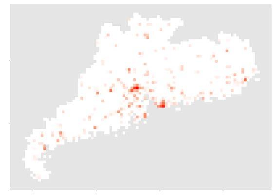
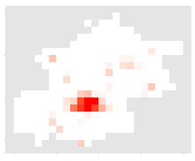
11 Urban extent from nightlights NTL Nightlights Google map High- Res Urban High-res Urban from NTL

12 Validations of mapped urban area USA China


13 Global urban areas mapping Parameter in the logistic model


14 Global urban areas in 2000


 N American S American Europe Africa Austria Russian Asian Global MODIS 500m GlobCover GLC2000 Natural Earth IMPSA 0.40 0.")
 N American S American Europe Africa Austria Russian Asian Global 0.")
15 Global urban areas (evaluation) Kappa Coef. MODIS 500m GlobCover GLC2000 Natural Earth IMPSA Overall Accuracy Producer Accuracy (1-Omission) N American S American Europe Africa Austria Russian Asian Global MODIS 500m GlobCover GLC2000 Natural Earth IMPSA User Accuracy (1-Commission) N American S American Europe Africa Austria Russian Asian Global

16 Global urban areas (6 products)
17 Urban dynamics mapping Inter-calibration of the annual nighttime lights products Parameterization of the logistic model Urban dynamics mapping using the cluster based method Zhao, N., Y. Zhou, Correcting incompatible DN values and geometric errors in nighttime lights time series images. IEEE transactions on Geoscience and Remote Sensing. In review.

18 Urbanization in China (evaluation)


19 Urbanization in China ( ) Beijing Guangdong Shanghai
20 Urbanization in each province ( )


21 Urban area & population
22 Summary and future work Summary The cluster-based method performs well in mapping urban extents from nightlights over large areas The method shows its potential to map global urban areas and temporal dynamics The preliminary results indicate that urbanization shows large spatial and temporal heterogeneity Future work Refine global urbanization mapping Predict future global urbanization Evaluate the environmental impacts of global urbanization


23 Acknowledgements NASA ROSES LCLUC Program Collaborators S. Smith A. Thomson B. Bond-Lamberty M. Imhoff K. Zhao C. Elvidge J. Eom K. Clarke Many colleagues and organizations that shared the data used in this project
Defining microclimates on Long Island using interannual surface temperature records from satellite imagery
 Defining microclimates on Long Island using interannual surface temperature records from satellite imagery Deanne Rogers*, Katherine Schwarting, and Gilbert Hanson Dept. of Geosciences, Stony Brook University,
Projecting Urban Land Cover on the basis of Population
 Projecting Urban Land Cover on the basis of Population Dan Miller Runfola Postdoctoral Researcher National Center for Atmospheric Research CGD & RAL CU:Boulder Institute of Behavioral Science 1 The Challenge
Urban land value, Accessibility and Night Light Data: A Case Study in China
 309-Paper Urban land value, Accessibility and Night Light Data: A Case Study in China Sumeeta Srinivasan, and Deng Yu Abstract In this paper, we use night light imagery data at two scales the city and
Greening of Arctic: Knowledge and Uncertainties
 Greening of Arctic: Knowledge and Uncertainties Jiong Jia, Hesong Wang Chinese Academy of Science jiong@tea.ac.cn Howie Epstein Skip Walker Moscow, January 28, 2008 Global Warming and Its Impact IMPACTS
Preparation of LULC map from GE images for GIS based Urban Hydrological Modeling
 International Conference on Modeling Tools for Sustainable Water Resources Management Department of Civil Engineering, Indian Institute of Technology Hyderabad: 28-29 December 2014 Abstract Preparation
Global Night Time Lights Urban Extents and Growth Patterns Product 1
 Global Night Time Lights Urban Extents and Growth Patterns Product 1 (Alpha Version) Technical Documentation Prepared by Mark Roberts, Benjamin Stewart, Mihir Prakash and Katie McWilliams GSURR & ITSQS
The footprint of urban heat island effect in China
 A discussion on the paper The footprint of urban heat island effect in China By Decheng Zhou, Shuqing Zhao, Liangxia Zhang, Ge Sun & Yongqiang Liu Published in SCIENCE REPORRTS Reporter: Mu Qingchen 2015.10.23
West meets East: Monitoring and modeling urbanization in China Land Cover-Land Use Change Program Science Team Meeting April 3, 2012
 West meets East: Monitoring and modeling urbanization in China Land Cover-Land Use Change Program Science Team Meeting April 3, 2012 Annemarie Schneider Center for Sustainability and the Global Environment,
Geo-spatial Statistics with Globalland30
 UN International Workshop on Integrating Geospatial and Statistical Information Geo-spatial Statistics with Globalland30 Jun Chen 1,2 Lijun Chen 1, Ran Li 1 1 National Geomatics Center, China 2 International
Land Cover Project ESA Climate Change Initiative. Processing chain for land cover maps dedicated to climate modellers.
 Land Cover Project ESA Climate Change Initiative Processing chain for land cover maps dedicated to climate modellers land_cover_cci S. Bontemps 1, P. Defourny 1, V. Kalogirou 2, F.M. Seifert 2 and O. Arino
Applications of GIS and Remote Sensing for Analysis of Urban Heat Island
 Chuanxin Zhu Professor Peter V. August Professor Yeqiao Wang NRS 509 December 15, 2016 Applications of GIS and Remote Sensing for Analysis of Urban Heat Island Since the last century, the global mean surface
Land Use/Cover Changes & Modeling Urban Expansion of Nairobi City
 Land Use/Cover Changes & Modeling Urban Expansion of Nairobi City Overview Introduction Objectives Land use/cover changes Modeling with Cellular Automata Conclusions Introduction Urban land use/cover types
Access to global land cover reference datasets and their suitability for land cover mapping activities
 Access to global land cover reference datasets and their suitability for land cover mapping activities Brice Mora, N.E.Tsendbazar, M.Herold LPVE meeting, Frascati, January 29, 2014 Outlook 1. Background
Development of a Regional Land Cover Monitoring System In the Lower Mekong Region a Joint Effort Between SERVIR-Mekong and Partners -
 Mekong Development of a Regional Land Cover Monitoring System In the Lower Mekong Region a Joint Effort Between SERVIR-Mekong and Partners - Aekkapol Aekakkararungroj SERVIR-Mekong Asian Disaster Preparedness
Overview on Land Cover and Land Use Monitoring in Russia
 Russian Academy of Sciences Space Research Institute Overview on Land Cover and Land Use Monitoring in Russia Sergey Bartalev Joint NASA LCLUC Science Team Meeting and GOFC-GOLD/NERIN, NEESPI Workshop
Preliminary Research on Grassland Fineclassification
 IOP Conference Series: Earth and Environmental Science OPEN ACCESS Preliminary Research on Grassland Fineclassification Based on MODIS To cite this article: Z W Hu et al 2014 IOP Conf. Ser.: Earth Environ.
Short Communication Urban and rural temperature trends in proximity to large US cities:
 INTERNATIONAL JOURNAL OF CLIMATOLOGY Int. J. Climatol. 27: 1801 1807 (2007) Published online 7 September 2007 in Wiley InterScience (www.interscience.wiley.com).1555 Short Communication Urban and rural
Measuring urban sprawl in China by night time light images
 IOP Conference Series: Earth and Environmental Science PAPER OPEN ACCESS Measuring urban sprawl in China by night time light images To cite this article: Lu Liu and Lin Tang 2017 IOP Conf. Ser.: Earth
A new perspective on aerosol direct radiative effects in South Atlantic and Southern Africa
 A new perspective on aerosol direct radiative effects in South Atlantic and Southern Africa Ian Chang and Sundar A. Christopher Department of Atmospheric Science University of Alabama in Huntsville, U.S.A.
CURRICULUM VITAE (As of June 03, 2014) Xuefei Hu, Ph.D.
 Xuefei Hu, Ph.D.") CURRICULUM VITAE (As of June 03, 2014) Xuefei Hu, Ph.D. Postdoctoral Fellow Department of Environmental Health Rollins School of Public Health Emory University 1518 Clifton Rd., NE, Claudia N. Rollins
CURRICULUM VITAE (As of June 03, 2014) Xuefei Hu, Ph.D. Postdoctoral Fellow Department of Environmental Health Rollins School of Public Health Emory University 1518 Clifton Rd., NE, Claudia N. Rollins
Estimation of evapotranspiration using satellite TOA radiances Jian Peng
 Estimation of evapotranspiration using satellite TOA radiances Jian Peng Max Planck Institute for Meteorology Hamburg, Germany Satellite top of atmosphere radiances Slide: 2 / 31 Surface temperature/vegetation
Spatial Variability of Aerosol - Cloud Interactions over Indo - Gangetic Basin (IGB)
") Spatial Variability of Aerosol - Cloud Interactions over Indo - Gangetic Basin (IGB) Shani Tiwari Graduate School of Environmental Studies Nagoya University, Nagoya, Japan Email: pshanitiwari@gmail.com
Spatial Variability of Aerosol - Cloud Interactions over Indo - Gangetic Basin (IGB) Shani Tiwari Graduate School of Environmental Studies Nagoya University, Nagoya, Japan Email: pshanitiwari@gmail.com
SYNTHESIS OF LCLUC STUDIES ON URBANIZATION: STATE OF THE ART, GAPS IN KNOWLEDGE, AND NEW DIRECTIONS FOR REMOTE SENSING
 PROGRESS REPORT SYNTHESIS OF LCLUC STUDIES ON URBANIZATION: STATE OF THE ART, GAPS IN KNOWLEDGE, AND NEW DIRECTIONS FOR REMOTE SENSING NASA Grant NNX15AD43G Prepared by Karen C. Seto, PI, Yale Burak Güneralp,
Interannual variation of MODIS NDVI in Lake Taihu and its relation to climate in submerged macrophyte region
 Yale-NUIST Center on Atmospheric Environment Interannual variation of MODIS NDVI in Lake Taihu and its relation to climate in submerged macrophyte region ZhangZhen 2015.07.10 1 Outline Introduction Data
C2VSim Fine Grid (C2VSim-FG) Version Development & Applications
 Version Development & Applications") C2VSim Fine Grid (C2VSim-FG) Version Development & Applications 2014 CWEMF Annual Meeting February 24, 2014 Presenters: Ali Taghavi & Mesut Cayar Collaborators: Reza Namvar (RMC), Jim Blanke (RMC), Tariq
C2VSim Fine Grid (C2VSim-FG) Version Development & Applications 2014 CWEMF Annual Meeting February 24, 2014 Presenters: Ali Taghavi & Mesut Cayar Collaborators: Reza Namvar (RMC), Jim Blanke (RMC), Tariq
ISTAMBUL April 22, pm
 Global Urban Data Initiative ISTAMBUL April 22, 11-12.30 pm Tokyo Ho Chi Minh Moscow Global Urban Data Initiative Global Urban and DRM Unit LEARN ABOUT: Data Access through PUMA Portal and ESA Urban Thematic
This is trial version
 Journal of Rangeland Science, 2012, Vol. 2, No. 2 J. Barkhordari and T. Vardanian/ 459 Contents available at ISC and SID Journal homepage: www.rangeland.ir Full Paper Article: Using Post-Classification
Dynamics of Urban Density in China: Estimations Based on DMSP/OLS Nighttime Light Data
 Title Dynamics of Urban Density in China: Estimations Based on DMSP/OLS Nighttime Light Data Author(s) Wu, J; Ma, L; Li, W; Peng, J; Liu, H Citation IEEE Journal of Selected Topics in Applied Earth Observations
Earth Observation & GeoSpatial Information for Monitoring Urban SDG Indicators. Global Urbanization Trend
 Earth Observation & GeoSpatial Information for Monitoring Urban SDG Indicators Yifang Ban, Professor Director, Division of Geoinformatics Vice Chair, Department for Urban Planning and Environment KTH Royal
Derivation of phenometrics from high resolution RapidEye imagery of semi-arid grasslands in South Africa
 André Parplies Student Research Colloquium Derivation of phenometrics from high resolution RapidEye imagery of semi-arid grasslands in South Africa Introduction Introduction Study area Methodology Results
Aniekan Eyoh 1* Department of Geoinformatics & Surveying, Faculty of Environmental Studies, University of Uyo, Nigeria
 Available online at http://euroasiapub.org/journals.php, pp. 53~62 Thomson Reuters Researcher ID: L-5236-2015 TEMPORAL APPRAISAL OF LAND SURFACE TEMPERATURE DYNAMICS ACROSS THE NINE STATES OF NIGER DELTA
DEM-based Ecological Rainfall-Runoff Modelling in. Mountainous Area of Hong Kong
 DEM-based Ecological Rainfall-Runoff Modelling in Mountainous Area of Hong Kong Qiming Zhou 1,2, Junyi Huang 1* 1 Department of Geography and Centre for Geo-computation Studies, Hong Kong Baptist University,
Comparing the diurnal and seasonal variabilities of atmospheric and surface urban heat islands based on the Beijing urban meteorological network
 Comparing the diurnal and seasonal variabilities of atmospheric and surface urban heat islands based on the Beijing urban meteorological network Kaicun Wang, Shaojing Jiang, Jiankai Wang, Chunlüe Zhou,
4/18/2006 Olga N. Krankina, OSU
 (Northern Eurasia Landcover Dynamics Analysis) Monitoring and validating the distribution and change in land cover across Northern Eurasia Objectives Characterize land cover and its change across boreal
Out of the Ice Age: How Indonesian Stalagmites Trace Changes in the Australasian Monsoon
 Out of the Ice Age: How Indonesian Stalagmites Trace Changes in the Australasian Monsoon 20th Anniversary Celebration NOAA Climate and Global Change Postdoctoral Program Dr. Michael L. Griffiths UC Irvine
Satellite-based assessment of rapid mega-urban development on agricultural land
 Short Paper Journal of Agricultural Meteorology 74 2 87 91, 2018 Satellite-based assessment of rapid mega-urban development on agricultural land Sungwook HONG a, Yang-Won LEE b, Jae-Hyun RYU c, Jong-Min
Impact of NASA EOS data on the scientific literature: 16 years of published research results from Terra, Aqua, Aura, and Aquarius
 Impact of NASA EOS data on the scientific literature: 16 years of published research results from Terra, Aqua, Aura, and Aquarius Gene R. Major NASA Goddard Library Nebulous Connections April 4, 2017 RESACs/RA
AGOG 485/585 /APLN 533 Spring Lecture 5: MODIS land cover product (MCD12Q1). Additional sources of MODIS data
. Additional sources of MODIS data") AGOG 485/585 /APLN 533 Spring 2019 Lecture 5: MODIS land cover product (MCD12Q1). Additional sources of MODIS data Outline Current status of land cover products Overview of the MCD12Q1 algorithm Mapping
AGOG 485/585 /APLN 533 Spring 2019 Lecture 5: MODIS land cover product (MCD12Q1). Additional sources of MODIS data Outline Current status of land cover products Overview of the MCD12Q1 algorithm Mapping
Lech GAWUC, Joanna STRUZEWSKA. Meteorology Division Faculty of Environmental Engineering Warsaw University of Technology Warsaw, Poland
 Analysis of the impact of different temporal aggregation techniques of land surface temperature on SUHI indicators and the relationship of surface temperature with population density and night lighting
Jobs-Housing Fit: Linking Housing Affordability and Local Wages
 Jobs-Housing Fit: Linking Housing Affordability and Local Wages Alex Karner, PhD Assistant Professor School of City and Regional Planning Georgia Institute of Technology Chris Benner, PhD Dorothy E. Everett
Land abandonment and recultivation in Central and Eastern Europe
 Land abandonment and recultivation in Central and Eastern Europe Patrick Hostert Patrick Griffiths, Stephan Estel, Camilo Alcantara, Tobias Kuemmerle, Dirk Pflugmacher, Alexander Prishchepov, Volker Radeloff
Aerosol Optical Depth Variation over European Region during the Last Fourteen Years
 Aerosol Optical Depth Variation over European Region during the Last Fourteen Years Shefali Singh M.Tech. Student in Computer Science and Engineering at Meerut Institute of Engineering and Technology,
Outline. Artificial night lighting as seen from space. Artificial night lighting as seen from space. Applications based on DMSP nighttime lights
 -1 - Outline Satellite observed nighttime lights as an indicator of human induced stress on coral C. Aubrecht, C.D. Elvidge August 22, 2008 Kuffner Observatory Vienna, Austria Artificial night lighting
Delineating Climate Relevant Structures for the Beijing Metropolitan Area
 Delineating Climate Relevant Structures for the Beijing Metropolitan Area 1,2 3,4 1 Austrian Academy of Sciences GIScience, Salzburg 2 Insitute for Geography, University of Bamberg, Germany 3 ispace, Austrian
The European Commission s science and knowledge service. Joint Research Centre
 The European Commission s science and knowledge service Joint Research Centre Global Urbanisation Pattern observed with EO data Thomas Kemper & GHSL team Urban Studies Symposium, University of Twente,
Domestic trade impacts of the expansion of the National Expressway Network in China
 Domestic trade impacts of the expansion of the National Expressway Network in China Chris Bennett, Piet Buys, Wenling Chen, Uwe Deichmann and Aurelio Menendez World Bank EASTE & DECRG Draft June 26, 2007
MODIS and VIIRS Reflective Solar Calibration Update
 MODIS and VIIRS Reflective Solar Calibration Update X. Xiong 1, C. Cao 2, A. Angal 3, S. Blonski 4, N. Lei 3, W. Wang 4, Z. Wang 3, and A. Wu 3 1 NASA GSFC, MD 20771, USA; 2 NOAA NESDIS, MD 20740, USA
Spati-temporal Changes of NDVI and Their Relations with Precipitation and Temperature in Yangtze River Catchment from 1992 to 2001
 Spati-temporal Changes of NDVI and Their Relations with Precipitation and Temperature in Yangtze River Catchment from 1992 to 2001 ZHANG Li 1, CHEN Xiao-Ling 1, 2 1State Key Laboratory of Information Engineering
Students: Michelle (Xue) Li (Michigan State U) Huiqing Huang (Michigan State U)
 Li (Michigan State U) Huiqing Huang (Michigan State U)") Researchers: Peilei Fan (Michigan State U) Joseph Messina (Michigan State U) Nathan Moore (Michigan State U) Jianjun Ge (Oklahoma State U) Peter Verburg, (VU University Amsterdam) Wenze Yue (MSU and Zhejiang
Researchers: Peilei Fan (Michigan State U) Joseph Messina (Michigan State U) Nathan Moore (Michigan State U) Jianjun Ge (Oklahoma State U) Peter Verburg, (VU University Amsterdam) Wenze Yue (MSU and Zhejiang
Spatial Geotechnologies and GIS tools for urban planners applied to the analysis of urban heat island. Case Caracas city, Venezuela Contribution 115.
 planners applied to the analysis of urban heat island. Case Caracas city, Venezuela Contribution 115. Fig.1 The city of Caracas, as many others Latin-American cities, has experimented a fast growth in
Opportunities provided by fine-scale meteorological sensor array
 Opportunities provided by fine-scale meteorological sensor array R.M. Randall, C.M Hocut, D.K. Knapp, B.T. MacCall, & J.A. Smith MSA Program Overview Army Challenge Research gaps exist which challenge
To link to this article:
 This article was downloaded by: [East China Normal University], [Dr Bailang Yu] On: 22 April 2014, At: 18:04 Publisher: Taylor & Francis Informa Ltd Registered in England and Wales Registered Number: 1072954
REMOTE SENSING AND GIS AS POLLUTION MODEL VALIDATION AND EMISSION ASSESSMENT TOOLS. Athens, Athens, Greece
 REMOTE SENSING AND GIS AS POLLUTION MODEL VALIDATION AND EMISSION ASSESSMENT TOOLS Michael Petrakis 1, Theodora Kopania 1, David Briggs 2, Asbjorn Aaheim 3, Gerard Hoek 4, Gavin Shaddick 5, Adrianos Retalis
INTERNATIONAL EARTH OBSERVATION INITIATIVES AND PROGRAMS: THE CONTEXT FOR GLOBAL URBAN MAPPING
 INTERNATIONAL EARTH OBSERVATION INITIATIVES AND PROGRAMS: THE CONTEXT FOR GLOBAL URBAN MAPPING Martin Herold a and Christiane C. Schmullius a a ESA GOFC-GOLD Land Cover Project Office, Dep. of Geography,
A computationally efficient approach to generate large ensembles of coherent climate data for GCAM
 A computationally efficient approach to generate large ensembles of coherent climate data for GCAM GCAM Community Modeling Meeting Joint Global Change Research Institute, College Park MD November 7 th,
The Nansen-Zhu International Research Centre: Beijing, China
 The Nansen-Zhu International Research Centre: Beijing, China Vision To become an internationally acknowledged climate research and training centre with emphasis on tropical and highlatitude regions, and
New COST Action: Towards a European Network on Chemical Weather Forecasting and Information Systems
 New COST Action: Towards a European Network on Chemical Weather Forecasting and Information Systems Proposer: Mikhail Sofiev Finnish Meteorological Institute Historical background EUMETNET Workshop on
A Study of the Uncertainty in Future Caribbean Climate Using the PRECIS Regional Climate Model
 A Study of the Uncertainty in Future Caribbean Climate Using the PRECIS Regional Climate Model by Abel Centella and Arnoldo Bezanilla Institute of Meteorology, Cuba & Kenrick R. Leslie Caribbean Community
Yu (Marco) Nie. Appointment Northwestern University Assistant Professor, Department of Civil and Environmental Engineering, Fall present.
 Nie. Appointment Northwestern University Assistant Professor, Department of Civil and Environmental Engineering, Fall present.") Yu (Marco) Nie A328 Technological Institute Civil and Environmental Engineering 2145 Sheridan Road, Evanston, IL 60202-3129 Phone: (847) 467-0502 Fax: (847) 491-4011 Email: y-nie@northwestern.edu Appointment
Yu (Marco) Nie A328 Technological Institute Civil and Environmental Engineering 2145 Sheridan Road, Evanston, IL 60202-3129 Phone: (847) 467-0502 Fax: (847) 491-4011 Email: y-nie@northwestern.edu Appointment
Expert Meeting: for Preparedness and Emergency Reponse. Land cover, land grabbing and. crowdsourcing
 Expert Meeting: Crowdsource Mapping for Preparedness and Emergency Reponse Land cover, land grabbing and drought: opportunities for crowdsourcing Why is it so important to improve global land cover? Originally
IAEG-SDGs WGGI Task Team Dec. 7, 2017, New York
 IAEG-SDGs WGGI Task Team Dec. 7, 2017, New York Contents What are G/A data? Role of G/A data Utilization Recommendations Outlook National Geospatial Data for SDGs Official data products generated by authoritative
Global temperature trend biases and statistical homogenization methods
 Global temperature trend biases and statistical homogenization methods Victor Venema & Ralf Lindau @VariabilityBlog variable-variability.blogspot.com Outline talk Early warming (1850 to 1920, red rectangle)
Permanent Ice and Snow
 Soil Moisture Active Passive (SMAP) Ancillary Data Report Permanent Ice and Snow Preliminary, v.1 SMAP Science Document no. 048 Kyle McDonald, E. Podest, E. Njoku Jet Propulsion Laboratory California Institute
A New Satellite Wind Climatology from QuikSCAT, WindSat, AMSR-E and SSM/I
 A New Satellite Wind Climatology from QuikSCAT, WindSat, AMSR-E and SSM/I Frank J. Wentz (presenting), Lucrezia Ricciardulli, Thomas Meissner, and Deborah Smith Remote Sensing Systems, Santa Rosa, CA Supported
Spatio-temporal dynamics of the urban fringe landscapes
 Spatio-temporal dynamics of the urban fringe landscapes Yulia Grinblat 1, 2 1 The Porter School of Environmental Studies, Tel Aviv University 2 Department of Geography and Human Environment, Tel Aviv University
Multi-scale and multi-sensor analysis of urban cluster development and agricultural land loss in India
 Multi-scale and multi-sensor analysis of urban cluster development and agricultural land loss in India Karen C. Seto, PI, Yale Michail Fragkias, Co-I, Arizona State Annemarie Schneider, Co-I, U of Wisconsin
Pan-Arctic, Regional and Local Land Cover Products
 Pan-Arctic, Regional and Local Land Cover Products Marcel Urban (1), Stefan Pöcking (1), Sören Hese (1) & Christiane Schmullius (1) (1) Friedrich-Schiller University Jena, Department of Earth Observation,
Mapping and Assessment of Ecosystems and their Services
 Mapping and Assessment of Ecosystems and their Services ALTER-Net Conference 2013: Science underpinning the EU 2020 Biodiversity Strategy. April 2013 Gent Joachim MAES 1 This presentation is based on the
Watershed Analysis Using Remote Sensing and GPS
 25 th Annual Louisiana Remote Sensing and GIS Workshop Baton Rouge, 2009 Watershed Analysis Using Remote Sensing and GPS Warren L. Kron, Jr. Quang Tran Baton Rouge City-Parish Planning Commission José
On Improving Precipitation Diurnal Cycle and Frequency in Global Climate Models
 On Improving Precipitation Diurnal Cycle and Frequency in Global Climate Models Xiaoqing Wu Department of Geological and Atmospheric Sciences Iowa State University (ISU) The YOTC International Science
Enhancement of the U.S. Drought Monitor Through the Integration of NASA Vegetation Index Imagery
 Enhancement of the U.S. Drought Monitor Through the Integration of NASA Vegetation Index Imagery Project and Related Activities at USGS/EROS Jim Verdin, Jesslyn Brown, Yingxin Gu, Gail Schmidt, Troy McVay
Pixel-based and object-based landslide mapping: a methodological comparison
 Pixel-based and object-based landslide mapping: a methodological comparison Daniel HÖLBLING 1, Tsai-Tsung TSAI 2, Clemens EISANK 1, Barbara FRIEDL 1, Chjeng-Lun SHIEH 2, and Thomas BLASCHKE 1 1 Department
Ocean Colour: Calibration Approach. CEOS WGCV-39, May The International Ocean Colour Coordinating Group
 Ocean Colour: Calibration Approach CEOS WGCV-39, May 2015 The International Ocean Colour Coordinating Group Ocean Colour requires special calibration considerations Percentage of ocean signal in the total
Urban Expansion. Urban Expansion: a global phenomenon with local causes? Stephen Sheppard Williams College
 Urban Expansion: a global phenomenon with local causes? Stephen Sheppard Williams College Presentation for World Bank, April 30, 2007 Presentations and papers available at http://www.williams.edu/economics/urbangrowth/homepage.htm
Rainfall Estimation Models Induced from Ground Station and Satellite Data
 Rainfall Estimation Models Induced from Ground Station and Satellite Data Kittisak Kerdprasop and Nittaya Kerdprasop Abstract Rainfall is an important source of water in agricultural sector of Thailand
Changes in the Spatial Distribution of Mobile Source Emissions due to the Interactions between Land-use and Regional Transportation Systems
 Changes in the Spatial Distribution of Mobile Source Emissions due to the Interactions between Land-use and Regional Transportation Systems A Framework for Analysis Urban Transportation Center University
Regional Frequency Analysis of Extreme Climate Events. Theoretical part of REFRAN-CV
 Regional Frequency Analysis of Extreme Climate Events. Theoretical part of REFRAN-CV Course outline Introduction L-moment statistics Identification of Homogeneous Regions L-moment ratio diagrams Example
GENERAL RECOMMENDATIONS. Session 7. Breakout discussion. discuss on regional and interregional. proposals 1. COLLABORATION BETWEEN PROGRAMMES
 Session 7 24 July 2016, 9.00-11.00 Breakout discussion on regional and interregional joint project proposals Mr Shahbaz Khan summarized the two days of presentations and exchanges and requested the participants
Using MODIS imagery to validate the spatial representation of snow cover extent obtained from SWAT in a data-scarce Chilean Andean watershed
 Using MODIS imagery to validate the spatial representation of snow cover extent obtained from SWAT in a data-scarce Chilean Andean watershed Alejandra Stehr 1, Oscar Link 2, Mauricio Aguayo 1 1 Centro
Cities in Bad Shape: Urban Geometry in India
 Cities in Bad Shape: Urban Geometry in India Mariaflavia Harari MIT IGC Cities Research Group Conference 21 May 2015 Introduction Why Study City Shape A wide range of factors determine intra-urban commuting
Curriculum Vitae. Ran Wei
 Curriculum Vitae Ran Wei Contact Information Mailing Address: Department of Geography University of Utah 260 S. Central Campus Dr., Rm. 270 Salt Lake City, UT 84112-9155, USA Phone: 1-801-581-8730 Email:
Building a validation database for land cover products from high spatial resolution images
 Building a validation database for land cover products from high spatial resolution images The Land Cover project of the ESA Climate Change Initiative Bontemps Sophie 1, Achard Frédéric 2, Lamarche Céline
Digital Change Detection Using Remotely Sensed Data for Monitoring Green Space Destruction in Tabriz
 Int. J. Environ. Res. 1 (1): 35-41, Winter 2007 ISSN:1735-6865 Graduate Faculty of Environment University of Tehran Digital Change Detection Using Remotely Sensed Data for Monitoring Green Space Destruction
Jun Chen 1, 2 National Geomatics Center of China NGCC. International Society for Photogrammetry and Remote Sensing ISPRS May12, 2017, Kunming
 Jun Chen 1, 2 National Geomatics Center of China NGCC 2 International Society for Photogrammetry and Remote Sensing ISPRS May12, 2017, Kunming Contents Introduction GlobeLand30 as Example Role and Utilization
Temperature and rainfall changes over East Africa from multi-gcm forced RegCM projections
 Temperature and rainfall changes over East Africa from multi-gcm forced RegCM projections Gulilat Tefera Diro and Adrian Tompkins - Earth System Physics Section International Centre for Theoretical Physics
Current LCLUC challenges in SCERIN: Assessing Ecosystem Function and Processes
 Summary of the SCERIN 2 meeting Current LCLUC challenges in SCERIN: Assessing Ecosystem Function and Processes Katarzyna Ostapowicz Department of GIS, Cartography and Remote Sensing, Institute of Geography
Using Remote Sensing to Analyze River Geomorphology
 Using Remote Sensing to Analyze River Geomorphology Seeing Water from Space Workshop August 11 th, 2015 George Allen geoallen@unc.edu Rivers impact: Geology Ecology Humans The atmosphere River Geomorphology
Mapping the Constructed Surface Area Density for China
 Proceedings of the 31 st Meeting of the Asia-Pacific Advanced Network Mapping the Constructed Surface Area Density for China Paul C. Sutton 1*, Christopher D. Elvidge 2, Kimberly Baugh 3 and 2 Daniel Ziskin
The effect of urban cover fraction on the retrieval of space-borne surface soil moisture at L-band
 19th International Congress on Modelling and Simulation, Perth, Australia, 12 16 December 2011 http://mssanz.org.au/modsim2011 The effect of urban cover fraction on the retrieval of space-borne surface
Using co-clustering to analyze spatio-temporal patterns: a case study based on spring phenology
 Using co-clustering to analyze spatio-temporal patterns: a case study based on spring phenology R. Zurita-Milla, X. Wu, M.J. Kraak Faculty of Geo-Information Science and Earth Observation (ITC), University
EXTRACTION OF REMOTE SENSING INFORMATION OF BANANA UNDER SUPPORT OF 3S TECHNOLOGY IN GUANGXI PROVINCE
 EXTRACTION OF REMOTE SENSING INFORMATION OF BANANA UNDER SUPPORT OF 3S TECHNOLOGY IN GUANGXI PROVINCE Xin Yang 1,2,*, Han Sun 1, 2, Zongkun Tan 1, 2, Meihua Ding 1, 2 1 Remote Sensing Application and Test
choice have on a particular application? For example, Fritz et al. (2010a) have shown that comparing global land cover (GLC-2000) with the equivalent
 have shown that comparing global land cover (GLC-2000) with the equivalent") Improving Global Land Cover through Crowd-sourcing and Map Integration L. See 1, S. Fritz 1, I. McCallum 1, C. Schill 2, C. Perger 3 and M. Obersteiner 1 1 International Institute for Applied Systems Analysis
Improving Global Land Cover through Crowd-sourcing and Map Integration L. See 1, S. Fritz 1, I. McCallum 1, C. Schill 2, C. Perger 3 and M. Obersteiner 1 1 International Institute for Applied Systems Analysis
The Field Research Facility, Duck, NC Warming Ocean Observations and Forecast of Effects
 The Field Research Facility, Duck, NC Warming Ocean Observations and Forecast of Effects A potential consequence of a warming ocean is more frequent and more intense wind events (Hurricanes & Typhoons)
Extremes Events in Climate Change Projections Jana Sillmann
 Extremes Events in Climate Change Projections Jana Sillmann Max Planck Institute for Meteorology International Max Planck Research School on Earth System Modeling Temperature distribution IPCC (2001) Outline
Capabilities and Limitations of Land Cover and Satellite Data for Biomass Estimation in African Ecosystems Valerio Avitabile
 Capabilities and Limitations of Land Cover and Satellite Data for Biomass Estimation in African Ecosystems Valerio Avitabile Kaniyo Pabidi - Budongo Forest Reserve November 13th, 2008 Outline of the presentation
MONITORING THE SURFACE HEAT ISLAND (SHI) EFFECTS OF INDUSTRIAL ENTERPRISES
 EFFECTS OF INDUSTRIAL ENTERPRISES") MONITORING THE SURFACE HEAT ISLAND (SHI) EFFECTS OF INDUSTRIAL ENTERPRISES A. Şekertekin a, *, Ş. H. Kutoglu a, S. Kaya b, A. M. Marangoz a a BEU, Engineering Faculty, Geomatics Engineering Department
MONITORING THE SURFACE HEAT ISLAND (SHI) EFFECTS OF INDUSTRIAL ENTERPRISES A. Şekertekin a, *, Ş. H. Kutoglu a, S. Kaya b, A. M. Marangoz a a BEU, Engineering Faculty, Geomatics Engineering Department
Sanjeev Kumar Jha Assistant Professor Earth and Environmental Sciences Indian Institute of Science Education and Research Bhopal
 Sanjeev Kumar Jha Assistant Professor Earth and Environmental Sciences Indian Institute of Science Education and Research Bhopal Email: sanjeevj@iiserb.ac.in 1 Outline 1. Motivation FloodNet Project in
Percentage of Vegetation Cover Change Monitoring in Wuhan Region Based on Remote Sensing
 Available online at www.sciencedirect.com Procedia Environmental Sciences 10 (2011 ) 1466 1472 2011 3rd International Conference on Environmental Science and Information Conference Application Title Technology
World Urban Database and Access Portal Tools (WUDAPT) Mapping Global Cities by Using a Common Language
 Mapping Global Cities by Using a Common Language") World Urban Database and Access Portal Tools (WUDAPT) Mapping Global Cities by Using a Common Language Prof. Chao REN*,The Chinese University of Hong Kong, Hong Kong Prof. Gerald MILLS, University College
World Urban Database and Access Portal Tools (WUDAPT) Mapping Global Cities by Using a Common Language Prof. Chao REN*,The Chinese University of Hong Kong, Hong Kong Prof. Gerald MILLS, University College
Bioimage Informatics for Systems Pharmacology
 Bioimage Informatics for Systems Pharmacology Authors : Fuhai Li Zheng Yin Guangxu Jin Hong Zhao Stephen T. C. Wong Presented by : Iffat chowdhury Motivation Image is worth for phenotypic changes identification