World Urban Database and Access Portal Tools (WUDAPT) Mapping Global Cities by Using a Common Language
|
|
|
- Paulina Sherman
- 5 years ago
- Views:
Transcription
, US Dr. Benjamin BECHTEL, University of Hamburg, Germany Dr.")
1 World Urban Database and Access Portal Tools (WUDAPT) Mapping Global Cities by Using a Common Language Prof. Chao REN*,The Chinese University of Hong Kong, Hong Kong Prof. Gerald MILLS, University College Dublin, Ireland Dr. Jason CHING, University of North Carolina (Chapel Hill), US Dr. Benjamin BECHTEL, University of Hamburg, Germany Dr. Linda SEE, International Institute for Applied Systems Analysis, Austria Dr. Valéry MASSON, Meteo France, France Prof. Johannes FEDDEMA, University of Victoria, Canada (*corresponding person: renchao@cuh.edu.hk )

2 Grey's Anatomy
3 Grey's Anatomy

4 Grey's Anatomy

5 After Hurricane Flooding Issues Homes are damaged after Hurricane Irma struck in Philipsburg, on the Dutch Caribbean island of St. Martin on Sept. 6, Netherlands Ministry of Defense via AFP - Getty Images
 notes the Events would")
6 More Unpredictable Weather Extremes. The most recent report from the The length, frequency and/or Intergovernmental Panel on intensity of Extreme Weather Climate Change (IPCC) notes the Events would likely increase over dearth of information on urban most land areas in the 21 century. areas. (The IPCC Special Report on Extremes, 2012)

7 Cities have the power to change the world, but cities are as vulnerable as they are powerful.

8


9 In HABITAT III, WE DECIDE THE FUTURE OF CITIES TOGETHER New Urban Agenda Quito Declaration on Sustainable Cities and Human Settlements for All Quito implementation plan for the New Urban Agenda Transformative commitments for sustainable urban development from: social, economic and environmental dimensions


10 How data science and analytics can contribute to sustainable development?

11 Urban Data Challenges at Global Scale Some examples of global scale data for the city of Delhi, India

12 The Question is how to make a cross-comparison among City A, City B, City C..?


13 London Cape Town, South Africa Cities present very rough, heterogenous surfaces.
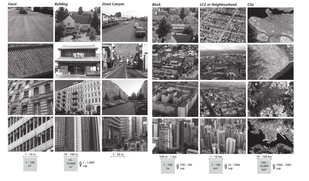
14
15 The Missing Link Scientific Community Design Stakeholders Gap? Linkage? Meteorologists, Climatologists,Ecologists, Aerodynamists, Wind Engineers,Environmental Scientists, GIS and Remote Sensing Researchers, etc. Town Planners, Architects, Landscape Architects, Governmental Officials, Policy Makers, etc..
16 The Missing Link & Need Problems Urban Data Availability & Accessibility Censuses of Urban Data Data Standardization & Harmonization Properties Applications Issues & Facts Few or no-data available globally on cities (Global South and rural / peri-urban areas especially in developing countries, regions and cities) No consensus of urban data for climate related studies (The dearth information of urban areas) No standard classification to represent land use and land cover of cities and surroundings landscapes (Densities, heights, functions and natural coverage for distinction) Offer multiple properties on urban morphologies and landscapes (Morphologies, geometrics, thermal / physical information, surface cover ) Applicable globally and transferable to each city (Transdisciplinarity for scientific research, urban planning, disaster & risk management, health impact analysis and response )


17 Local Climate Zone Scheme (Stewart & Oke, 2012)
 The most recent")
 notes the")

18 The World Urban Database and Access Portal Tools (WUDAPT) The most recent report from the Intergovernmental Panel on Climate Change (IPCC) notes the dearth of information on urban areas. The goal of the WUDAPT initiative is to fill this demand.

 that will EXTRACT relevant urban parameters and properties for")
19 Two Objectives Objective 1 Acquire and make accessible coherent and consistent descriptions and information in the aspects of FORM And FUNCTION of cities relevant to climate studies on WORLDWIDE basis. Objective 2 Build Portal (tools) that will EXTRACT relevant urban parameters and properties for models and for model APPLICATIONS at appropriate scales for various climate, weather, Urban Planning purposes.
20 3 Levels of WUDAPT Products Level 0 Cities are mapped using the Local Climate Zone scheme (Stewart & Oke, 2012). Each LCZ type is described in terms of the typical appearance of each in groundbased and aerial photographs and is linked to some urban parameter values. Level 1 The LCZ maps are used to sample urban landscapes to provide more information on the aspects of form and function in greater details. Level 2 This is the highest level and it refers to urban data gathered at a specified spatial scale (e.g. 250 m) across the entire urban area ( wall-to-wall coverage). (Ching, et al., 2016)
 WUDAPT cities C40 cities in")
21 More than 150 Cities involved (Jun. 2017) WUDAPT cities C40 cities in green

22 Urban Data Challenges Some examples of global scale data sets compared to a WUDAPT level 0 map for the city of Delhi, India

23

24


25 Collaboration Partners & Supporters Core Teams The Chinese University of Hong Kong
26 Level 0 WUDAPT Product & Applications CUHK team s work and efforts 26


27 WUDAPT: Major Cities in China Beijing Shanghai Wuhan Guangzhou Changsha Dalian Guangzhou Hangzhou Jinan Nanjing Qingdao Shanghai Shenyang Tianjing Xi an Xiamen When you later work on urban climate study in China, you don t need to worry about its urban morphological data. By Jun 2016, we have finished the LCZ mapping work for 57 all provincial capital cities and major economic big regions.


28 Historical Urban Data Bay Area Of Hong Kong-Macau-Guangdong pure urbanization impact on local urban climate( ) 2002 Weather Reinforce Forecasting(WRF) Modelling Simulation Results Temperature(AM) Temperature(PM) Wind(AM) Wind(PM) Heat Stress(PM)


 Low-cost;")


29 3-D Urban Morphological Data by Adopting Multi-source Satellite Images 3-D Urban Morphological Data Patented technology High accuracy (70-90%) Low-cost; Fast development ; Large coverage; Easy to update and manage; Suitable for weather and climate modellings Urban Climate Evaluation Climatic Simulations


30 2017 IEEE GRSS Data Fusion Contest Open data for global multimodal land use classification The 2017 IEEE GRSS Data Fusion Contest was organized by the IADF TC in collaboration with WUDAPT and GeoWiki. Over 800 Submissions were received! We are Top 4! Authors: Yong Xu, Fan Ma, Deyu Meng, Chao Ren, Yee Leung (The Chinese University of Hong Kong and Xi an Jiaotong University, China)
31 Other on-going Collaborations and Applications


32 Bechtel, B., et al. (2016). TOWARDS CONSISTENT MAPPING OF URBAN STRUCTURES GLOBAL HUMAN SETTLEMENT LAYER AND LOCAL CLIMATE ZONES. Paper presented at the The International Archives of the Photogrammetry, Remote Sensing and Spatial Information Sciences, Prague, Czech Republic Atlas of the Human Planet Collaboration with GEO, European Commission On-going Projects & Collaborations Population Grid in 3D - Asia Atlas of the Human Planet Source: Atlas of the Human Planet, GEO
.")


33 Global Human Settlement Layer (GHSL) vs WUDAPT Data WUDAPT GHP WUDAPT GHP Bechtel, B., et al. (2016). TOWARDS CONSISTENT MAPPING OF URBAN STRUCTURES GLOBAL HUMAN SETTLEMENT LAYER AND LOCAL CLIMATE ZONES. Paper presented at the The International Archives of the Photogrammetry, Remote Sensing and Spatial Information Sciences, Prague, Czech Republic


34 Global Carbon Atlas Project New focus Building a modest database on cities carbon emission and of key drivers Examining alternative urban designs


35 Healthy City Development for Latin American Cities


36 Digital Belt & Road Initiative Collaboration with the Chinese Academy of Sciences On-going Projects & Collaborations 80 Selected Cities, 20 Countries Support and Involvement Yangon, Myanmar Warsaw, Poland Karachi, Pakistan Tehran, Iran
37 Collaboration between WUDAPT and


38 The Development of Global WUDAPT Level 0 Data WUDAPT s innovative method, technologies and expertise + Google (data mining+ satellite images resources+ online system) A Special Project of Google Earth Outreach A New Urban Database in Google Earth Engine Catalog? +? Urban Morphology
39 The Development of Global WUDAPT Level 1+2 Data


40


41 The Development of Historical Urban Data using Google Earth Timelapse Technology


42 Roadmap of WUDAPT Global Initiative Project Develop Data Science and Informatics Technology Conduct Applications & Implementations Make Policy Changed Link People together Improve Urban Environment and Living Quality Change People s Life Have a Better Future for all


43 Data Science in Time, Data Science in Space We have an Idea. We have the Technology and we have the Team All we need is further Collaborations and Resources Will YOU join us?

44 Thanks. Any Questions?
45
46

 Size, Form,")
47 What influences Urban Climate? Fixed Location Modulators Time, Weather Manageable (policy, planning, design) Size, Form, Metabolism
WUDAPT Global Initiative: Census of Global Cities
 WUDAPT Global Initiative: Census of Global Cities I Background and Challenges We are living in an urbanized world, yet we know very little about most cities on the planet, especially how they are built
ScienceDirect. Local Climate Zone Study for Sustainable Megacities Development by Using Improved WUDAPT Methodology A Case Study in Guangzhou
 Available online at www.sciencedirect.com ScienceDirect Procedia Environmental Sciences 36 (2016 ) 82 89 International Conference on Geographies of Health and Living in Cities: Making Cities Healthy for
Generating WUDAPT s Specific Scale-dependent Urban Modelling and Activity Parameters: Collection of Level 1 and Level 2 Data
 ICUC9, Toulouse, France, 2015 Generating WUDAPT s Specific Scale-dependent Urban Modelling and Activity Parameters: Collection of Level 1 and Level 2 Data Linda See, Jason Ching 2, Valéry Masson 3, Johannes
The Portal Component, Strategic Perspectives and Review of Tactical plans to implement the IAUC Initiative, WUDAPT ; a worldwide urban database for
 The Portal Component, Strategic Perspectives and Review of Tactical plans to implement the IAUC Initiative, WUDAPT ; a worldwide urban database for climate and environmental modeling Jason Ching Institute
Developing a global, people-based definition of cities and settlements
 Developing a global, people-based definition of cities and settlements Cooperation between: Directorate General for Regional and, Joint Research Centre, EUROSTAT (European Commission, European Union) OECD,
Prentice Hall. World Explorer: People, Places, Cultures Grade 7. Oklahoma Priority Academic Student Skills (PASS) for Grade 7 World Geography
 for Grade 7 World Geography") Prentice Hall World Explorer: People, Places, Cultures 2007 Grade 7 C O R R E L A T E D T O for Grade 7 1. Locate, gather, analyze, and apply information from primary and secondary sources. WORLD GEOGRAPHY
Prentice Hall World Explorer: People, Places, Cultures 2007 Grade 7 C O R R E L A T E D T O for Grade 7 1. Locate, gather, analyze, and apply information from primary and secondary sources. WORLD GEOGRAPHY
Building Institutional Capacity for Multi-Hazard Early Warning in Asia and the Pacific Subtitle
 Building Institutional Capacity for Multi-Hazard Early Warning in Asia and the Pacific Subtitle Title Keran Wang Chief, Space Applications Section ICT and Disaster Risk Reduction Division 22 May 2018 Pillar
Determining the Optimal Grid Size of Local Climate Zones for Spatial Mapping in High-density Cities
 Determining the Optimal Grid Size of Local Climate Zones for Spatial Mapping in High-density Cities Kevin Ka-Lun Lau, Chao Ren, Yuan Shi, Venessa Zheng,, Hong Kong Background Urbanization results in distinctive
Sensitivity of mesoscale models to scale dependent UCP inputs:
 9 th International Conference on Urban Climate, 20 th -24 th July 2015, Toulouse, France Sensitivity of mesoscale models to scale dependent UCP inputs: Urban thermofluid dynamics, multi-scale interactions,
West meets East: Monitoring and modeling urbanization in China Land Cover-Land Use Change Program Science Team Meeting April 3, 2012
 West meets East: Monitoring and modeling urbanization in China Land Cover-Land Use Change Program Science Team Meeting April 3, 2012 Annemarie Schneider Center for Sustainability and the Global Environment,
SDG s and the role of Earth Observation
 SDG s and the role of Earth Observation Christian Heipke IPI - Institute for Photogrammetry and GeoInformation Leibniz Universität Hannover Germany Secretary General, ISPRS 1. No Poverty 2. Zero Hunger
Spanish national plan for land observation: new collaborative production system in Europe
 ADVANCE UNEDITED VERSION UNITED NATIONS E/CONF.103/5/Add.1 Economic and Social Affairs 9 July 2013 Tenth United Nations Regional Cartographic Conference for the Americas New York, 19-23, August 2013 Item
Module 3 Indicator Land Consumption Rate to Population Growth Rate
 Regional Training Workshop on Human Settlement Indicators Module 3 Indicator 11.3.1 Land Consumption Rate to Population Growth Rate Dennis Mwaniki Global Urban Observatory, Research and Capacity Development
UN-GGIM: An Overview Stefan Schweinfest, Director (UNSD) Bangkok, 27 March 2015
 Bangkok, 27 March 2015") UN-GGIM: An Overview Stefan Schweinfest, Director (UNSD) Bangkok, 27 March 2015 ggim.un.org UN-GGIM: A global initiative Formal inter-governmental UN Committee of Experts to: Discuss, enhance and coordinate
UN-GGIM: An Overview Stefan Schweinfest, Director (UNSD) Bangkok, 27 March 2015 ggim.un.org UN-GGIM: A global initiative Formal inter-governmental UN Committee of Experts to: Discuss, enhance and coordinate
Space Applications for Disaster Risk Reduction and Sustainable Development
 Space Applications for Disaster Risk Reduction and Sustainable Development Space Applications Section (SAS) ICT and Disaster Risk Reduction Division (IDD) UNESCAP Contents I. RESAP Activities 2016-2017
Building Institutional Capacity for Multi-Hazard Early Warning in Pacific Countries Subtitle
 Building Institutional Capacity for Multi-Hazard Early Warning in Pacific Countries Subtitle Title Keran Wang Chief, Space Applications Section ICT and Disaster Risk Reduction Division 30 March 2018 Slide
UNITED NATIONS E/CONF.96/CRP. 5
 UNITED NATIONS E/CONF.96/CRP. 5 ECONOMIC AND SOCIAL COUNCIL Eighth United Nations Regional Cartographic Conference for the Americas New York, 27 June -1 July 2005 Item 5 of the provisional agenda* COUNTRY
Urban Geo-Informatics John W Z Shi
 Urban Geo-Informatics John W Z Shi Urban Geo-Informatics studies the regularity, structure, behavior and interaction of natural and artificial systems in the urban context, aiming at improving the living
Geospatial Information and Services for Disasters (GIS4D)
") Geospatial Information and Services for Disasters (GIS4D) 31 July 2017 Tae Hyung KIM ICT and Disaster Risk Reduction Division (IDD) UNESCAP 1 About ESCAP Who is ESCAP? United Nations Economic and Social
Geospatial Information and Services for Disasters (GIS4D) 31 July 2017 Tae Hyung KIM ICT and Disaster Risk Reduction Division (IDD) UNESCAP 1 About ESCAP Who is ESCAP? United Nations Economic and Social
SDI Developments in the World s Currently Existing Mega Cities
 SDI Developments in the World s Currently Existing Mega Cities Silke Boos and Hartmut Müller FIG Working Week 2009 Surveyors Key Role in Accelerated Development, Eilat, Israel, 3-8 May 2009 TS 1B SDI in
Alleghany County Schools Curriculum Guide GRADE/COURSE: World Geography
 GRADE/COURSE: World 2013-14 GRADING PERIOD: 1 st Six Weeks Time Frame Unit/SOLs SOL # Strand Resource Assessment 8 days* The student will use maps, globes, satellite images, photographs, or diagrams to
UNIVERSITY OF SPATIAL ENGINEERING. PROF. DR. VICTOR JETTEN DRS. TINY LUITEN MBA
 UNIVERSITY OF SPATIAL ENGINEERING. PROF. DR. VICTOR JETTEN DRS. TINY LUITEN MBA 5. PRACTICAL INFO 1. WHY ON EARTH SPATIAL ENGINEERING? 4. WHAT IS THERE AFTER YOU FINISH? 2. WHAT CAN YOU DO? 3. HOW TO BECOME
2 nd Semester. Core Courses. C 2.1 City and Metropolitan Planning. Module 1: Urban Structure and Growth Implications
 2 nd Semester Core Courses C 2.1 City and Metropolitan Planning Module 1: Urban Structure and Growth Implications Growth of cities; cities as engine of growth; urban sprawl; land value, economic attributes
Geography Curriculum. Key Stage 1
 Geography Curriculum Key Stage 1 Year 1 In the first term, students explore a variety of maps of the local environment, including the Academy grounds. They use a paper location to plan a route. They also
ESPON evidence on European cities and metropolitan areas
 BEST METROPOLISES Final Conference 18 April 2013, Warsaw ESPON evidence on European cities and metropolitan areas Michaela Gensheimer Structure of Intervention Content Part I: What is the ESPON 2013 Programme?
How the science of cities can help European policy makers: new analysis and perspectives
 How the science of cities can help European policy makers: new analysis and perspectives By Lewis Dijkstra, PhD Deputy Head of the Economic Analysis Unit, DG Regional and European Commission Overview Data
ia PU BLi s g C o M Pa K T Wa i n CD-1576
 M h M y CD-1576 o M Pa g C n ar ia PU BLi s in K T Wa i n ed National Geography Standards National Geography Standards Teachers leading discussions while completing units and activities is a prerequisite
Vincent Goodstadt. Head of European Affairs METREX European Network
 Vincent Goodstadt Head of European Affairs METREX European Network METREX (Network of 50 European Metropolitan Regions and Areas ) Exchanging Knowledge (e.g. Benchmarking) Climate Change CO2/80/50 Expertise
Georeferencing and Satellite Image Support: Lessons learned, Challenges and Opportunities
 Georeferencing and Satellite Image Support: Lessons learned, Challenges and Opportunities Shirish Ravan shirish.ravan@unoosa.org UN-SPIDER United Nations Office for Outer Space Affairs (UNOOSA) UN-SPIDER
I&CLC2000 in support to new policy initiatives (INSPIRE, GMES,..)
") I&CLC2000 in support to new policy initiatives (INSPIRE, GMES,..) Manfred Grasserbauer, Director Joint Research Centre Institute for Environment and Sustainability 1 IMAGE 2000 European mosaic of satellite
I&CLC2000 in support to new policy initiatives (INSPIRE, GMES,..) Manfred Grasserbauer, Director Joint Research Centre Institute for Environment and Sustainability 1 IMAGE 2000 European mosaic of satellite
Looking at Communities: Comparing Urban and Rural Neighborhoods
 Looking at Communities: Comparing Urban and Rural Neighborhoods OVERVIEW & OBJECTIVES Our urban areas have become so dominant that frequently the children we teach have no connection with and very few
WMO Guide on Integrated Urban Weather, Environment and Climate Services for Cities (IUWECS) Hong Kong- an experience from a high-density city
 Hong Kong- an experience from a high-density city") WMO Guide on Integrated Urban Weather, Environment and Climate Services for Cities (IUWECS) Hong Kong- an experience from a high-density city Dr. Chao REN Associate Professor School of Architecture The
WMO Guide on Integrated Urban Weather, Environment and Climate Services for Cities (IUWECS) Hong Kong- an experience from a high-density city Dr. Chao REN Associate Professor School of Architecture The
Global Data Catalog initiative Christophe Charpentier ArcGIS Content Product Manager
 Global Data Catalog initiative Christophe Charpentier ArcGIS Content Product Manager ccharpentier@esri.com We are in a global economy Global Economy Business and Operations are now global Strategic need
9.1 The WUDAPT Project: Status of Database and Portal Tools
 9.1 The WUDAPT Project: Status of Database and Portal Tools G. Mills 1, B. Bechtel 2, M. Foley 1, Ching.J. 3, L See 4, J. Feddema 5 1 University College Dublin, Ireland, 2 University of Hamburg, Germany,
Development of A Rapid Typhoon Loss Estimation System in China
 1 st Annual Conference of the International Society for Integrated Disaster Risk Management - IDRiM 2010 September 1-4, 2010, Vienna, Austria Development of A Rapid Typhoon Loss Estimation System in China
National Disaster Management Centre (NDMC) Republic of Maldives. Location
 Republic of Maldives. Location") National Disaster Management Centre (NDMC) Republic of Maldives Location Country Profile 1,190 islands. 198 Inhabited Islands. Total land area 300 sq km Islands range b/w 0.2 5 sq km Population approx.
National Disaster Management Centre (NDMC) Republic of Maldives Location Country Profile 1,190 islands. 198 Inhabited Islands. Total land area 300 sq km Islands range b/w 0.2 5 sq km Population approx.
PERSPECTIVE ON URBAN CANOPY MODELING FOR WEATHER CLIMATE AND AIR QUALITY APPLICATIONS
 PERSPECTIVE ON URBAN CANOPY MODELING FOR WEATHER CLIMATE AND AIR QUALITY APPLICATIONS Jason Ching * *Institute for the Environment, The University of North Carolina, Chapel Hill, NC, USA Gerald Mills 1
ESCAP Promotes Geo-referenced Information System for Disaster Risk Management in Asia and the Pacific
 Third High Level Forum on UNGGIM 22-24 October 2014 Beijing, China ESCAP Promotes Geo-referenced Information System for Disaster Risk Management in Asia and the Pacific Keran Wang Space Applications Section,
Year 34 B2 Geography - Continents and Oceans 2018 Key Skills to be covered: Taken from Level 3 Taken from Level 4
 Key Skills to be covered: Taken from Level 3 Taken from Level 4 Geographical Enquiry: I ask, Which PHYSICAL features does this place have? I ask, Which HUMAN features does this place have? I give reasons
Global City Definition
 Regional Training Workshop on Human Settlement Indicators Global City Definition Dennis Mwaniki Global Urban Observatory, Research and Capacity Development Branch, UN-Habitat Bangkok, Thailand Outline
Sustainable Development Goal 11 and the New Urban Agenda: can planning deliver? Vanessa Watson University of Cape Town 2016
 Sustainable Development Goal 11 and the New Urban Agenda: can planning deliver? Vanessa Watson University of Cape Town 2016 .to reinvigorate the global political commitment to the sustainable development
Urban Spatial Scenario Design Modelling (USSDM) in Dar es Salaam: Background Information
 in Dar es Salaam: Background Information") Urban Spatial Scenario Design Modelling (USSDM) in Dar es Salaam: Background Information Modelling urban settlement dynamics in Dar es Salaam Revision: 2 (July 2013) Prepared by: Katja Buchta TUM team
Urban Spatial Scenario Design Modelling (USSDM) in Dar es Salaam: Background Information Modelling urban settlement dynamics in Dar es Salaam Revision: 2 (July 2013) Prepared by: Katja Buchta TUM team
European Spatial Data Research. EuroSDR. Prof. Dr. Ir. Joep Crompvoets. General Assembly CLGE Tirana 18 March
 EuroSDR Prof. Dr. Ir. Joep Crompvoets General Assembly CLGE - 2016 Tirana 18 March 2016 INTRODUCTORY QUESTIONS Who knows what is EuroSDR? Who does NOT know what is EuroSDR? Who is employed at mapping agencies?
Analysis of European Topographic Maps for Monitoring Settlement Development
 Analysis of European Topographic Maps for Monitoring Settlement Development Ulrike Schinke*, Hendrik Herold*, Gotthard Meinel*, Nikolas Prechtel** * Leibniz Institute of Ecological Urban and Regional Development,
Geospatial Information Management in the Americas: Lessons for the Post-2015 development agenda
 Geospatial Information Management in the Americas: Lessons for the Post-2015 development agenda Rolando Ocampo President, UN-GGIM: Americas October 2014 The integration of statistical and geographical
Lead WG: ICWG IV/III: Global Mapping: Updating, Verification and Interoperability
 Report on Scientific Initiative Project: An ISPRS contribution to Transforming Our World: augmentation of GlobeLand30 with additional data for monitoring United Nations Sustainable Development Goals Lead
Journey of supporting CSNs to establish Geo-DRM
 Regional Workshop on Geo-referenced Information Systems for Disaster Risk Management (Geo-DRM) 26-27 June 2014 Bangkok, Thailand Journey of supporting CSNs to establish Geo-DRM Keran Wang Chief, Space
RiskCity Training package on the Application of GIS for multi- hazard risk assessment in an urban environment.
 RiskCity Training package on the Application of GIS for multi- hazard risk assessment in an urban environment. Cees van Westen (Westen@itc.nl) & Nanette C. Kingma (Kingma@itc.nl) ITC: Training & Research
Geospatial Technologies for Resources Planning & Management
 Geospatial Technologies for Resources Planning & Management Lal Samarakoon, PhD Director, Geoinformatics Center Asian Institute of Technology, Thailand Content Geoinformatics for SDG Information Integration
Biodiversity and Ecosystem services Thinking globally, acting locally
 Biodiversity and Ecosystem services Thinking globally, acting locally Anne-Gaelle Ausseil - Manaaki Whenua Landcare Research Geoff Hicks National Commission for UNESCO 1 8 / 1 0 / 2 0 1 8 M A N A A K I
The Joint Programming Initiative on Cultural Heritage (JPICH): European perspective
: European perspective") COPERNICUS FOR CULTURAL HERITAGE Copernicus User Forum Industry Workshop Brussels, 24 April 2017 The Joint Programming Initiative on Cultural Heritage (JPICH): European perspective Cristina Sabbioni CNR,
COPERNICUS FOR CULTURAL HERITAGE Copernicus User Forum Industry Workshop Brussels, 24 April 2017 The Joint Programming Initiative on Cultural Heritage (JPICH): European perspective Cristina Sabbioni CNR,
Report of the Working Group 2 Data Sharing and Integration for Disaster Management *
 UNITED NATIONS E/CONF.104/6 ECONOMIC AND SOCIAL COUNCIL Twentieth United Nations Regional Cartographic Conference for Asia and the Pacific Jeju, 6-9 October 2015 Item 5 of the provisional agenda Report
Upgrade the Datasets in NSDI for Smarter Services with the Cases of China
 Upgrade the Datasets in NSDI for Smarter Services with the Cases of China By Dr. JIANG Jie Dept of GeoInformaiton Service Platform National Geomatics Center of China October 7, 2015 Jeju, Republic of Korea
Delineating Climate Relevant Structures for the Beijing Metropolitan Area
 Delineating Climate Relevant Structures for the Beijing Metropolitan Area 1,2 3,4 1 Austrian Academy of Sciences GIScience, Salzburg 2 Insitute for Geography, University of Bamberg, Germany 3 ispace, Austrian
The Integrated Ge spatial Information Framework to the strengthening of NSDI, Mongolia
 Young Geospatial Professionals Summit 21 NOV 2018 The Integrated Ge spatial Information Framework to the strengthening of NSDI, Mongolia BAYARMAA ENKHTUR Geospatial information and technology department
Major Opportunities in Spatial Data Infrastructure Communities
 Major Opportunities in Spatial Data Infrastructure Communities Bas Kok President GSDI June 17 th 2008 FIG Working Week: Integrating Generations 14-19 June 2008 Stockholm, Sweden http://www.gsdi.org 1 GSDI
Urban Planning for Climate Change
 Urban Planning for Climate Change FIG Working Group 8.1 Frank Friesecke, Sophie Schetke, Theo Kötter AGENDA 1. Introduction 2. Urbanisation and Climate Change 3. Need of the Surveying Profession in Dealing
Coimisiún na Scrúduithe Stáit State Examinations Commission
 M. 24 Coimisiún na Scrúduithe Stáit State Examinations Commission LEAVING CERTIFICATE EXAMINATION 2005 GEOGRAPHY HIGHER LEVEL MONDAY, 13 JUNE, AFTERNOON 1.30 TO 4.50 Four questions to be answered, namely
Oman NSDI Business Values and Future Directions. Hassan Alawi Alghazali Acting Director General National Spatial Data Infrastructure
 Oman NSDI Business Values and Future Directions Hassan Alawi Alghazali Acting Director General National Spatial Data Infrastructure Presentation Outline Geospatial Maturity Current Challenges NCSI s Role
Key Indicators for Territorial Cohesion & Spatial Planning Stakeholder Workshop - Project Update. 13 th December 2012 San Sebastián, Basque Country
 Key Indicators for Territorial Cohesion & Spatial Planning Stakeholder Workshop - Project Update 13 th December 2012 San Sebastián, Basque Country Key Aims Explore the use of territorial data in developing
Road & Railway Network Density Dataset at 1 km over the Belt and Road and Surround Region
 Journal of Global Change Data & Discovery. 2017, 1(4): 402-407 DOI:10.3974/geodp.2017.04.03 www.geodoi.ac.cn 2017 GCdataPR Global Change Research Data Publishing & Repository Road & Railway Network Density
GIS as a tool for rural livelihoods enhancement planning
 GIS as a tool for rural livelihoods enhancement planning (Case study of Alosylat region -Shareg Alnil-Sudan) Almojtaba M. H. Hassabo Federal Ministry of Agriculture Sudan A research submitted to the Development
GSDI Global Spatial Data Infrastructure. Convergences between Geo Spatial Communities: key decision for decision making
 GSDI Global Spatial Data Infrastructure Convergences between Geo Spatial Communities: key decision for decision making April 14 th 2010 Bas Kok GSDI Past-President Director of International Affairs, Dutch
From a North American to a Global Drought Monitor Richard R. Heim Jr.
 From a North American to a Global Drought Monitor Richard R. Heim Jr. NOAA/NESDIS/ Asheville, North Carolina, USA GEO-DRI Drought Monitoring Workshop Winnipeg, Manitoba, Canada 10-11 May 2010 NADM History
High Level Training Course on. World Heritage under the framework of Digital Belt and Road. (02 September 17 September, 2017)
") High Level Training Course on World Heritage under the framework of Digital Belt and Road (02 September 17 September, 2017) I. BACKGROUND The Silk Road Economic Belt and the 21st-Century Maritime Silk
High Level Training Course on World Heritage under the framework of Digital Belt and Road (02 September 17 September, 2017) I. BACKGROUND The Silk Road Economic Belt and the 21st-Century Maritime Silk
Social Science Data for High Latitudes
 LCLUC Science Team Meeting High Latitudes in the Context of the International Polar Year Social Science Data for High Latitudes 2 May 2008 Dr. Robert S. Chen Director and Senior Research Scientist, CIESIN
Space Application in Support of Land Management for SDG Implementation
 Space Application in Support of Land Management for SDG Implementation Regional Expert Workshop on Land Accounting for SDG Monitoring and Reporting 26 September 2017 Space Application Section Information
What on Earth is Geography? Using the Five Themes of Geography to Study the Continent of Asia.
 What on Earth is Geography? Using the Five Themes of Geography to Study the Continent of Asia. Name Date Essential questions: 1. How can we study the geography of our Earth? a. What are the five themes
Smart City Governance for effective urban governance. David Ludlow Assoc. Professor European Smart Cities University of the West of England, Bristol
 Smart City Governance for effective urban governance David Ludlow Assoc. Professor European Smart Cities University of the West of England, Bristol Complexities of urban territorial governance Complexities
WMO Public Weather Services: Enhanced Communication Skills for Improved Service Delivery. by S.W. Muchemi (WMO)
") WMO Public Weather Services: Enhanced Communication Skills for Improved Service Delivery by S.W. Muchemi (WMO) Functions of the Public Weather Services (PWS) programme of WMO To strengthen the capabilities
WMO Public Weather Services: Enhanced Communication Skills for Improved Service Delivery by S.W. Muchemi (WMO) Functions of the Public Weather Services (PWS) programme of WMO To strengthen the capabilities
Reassessing the conservation status of the giant panda using remote sensing
 SUPPLEMENTARY Brief Communication INFORMATION DOI: 10.1038/s41559-017-0317-1 In the format provided by the authors and unedited. Reassessing the conservation status of the giant panda using remote sensing
Remote sensing and GIS for multi-hazard risk assessments in the coastal zone: recent applications and challenges in the Pacific Jens Kruger
 Remote sensing and GIS for multi-hazard risk assessments in the coastal zone: recent applications and challenges in the Pacific Jens Kruger Geoscience Division Pacific Community (SPC) The First Pacific
URBAN CHANGE DETECTION OF LAHORE (PAKISTAN) USING A TIME SERIES OF SATELLITE IMAGES SINCE 1972
 USING A TIME SERIES OF SATELLITE IMAGES SINCE 1972") URBAN CHANGE DETECTION OF LAHORE (PAKISTAN) USING A TIME SERIES OF SATELLITE IMAGES SINCE 1972 Omar Riaz Department of Earth Sciences, University of Sargodha, Sargodha, PAKISTAN. omarriazpk@gmail.com ABSTRACT
URBAN CHANGE DETECTION OF LAHORE (PAKISTAN) USING A TIME SERIES OF SATELLITE IMAGES SINCE 1972 Omar Riaz Department of Earth Sciences, University of Sargodha, Sargodha, PAKISTAN. omarriazpk@gmail.com ABSTRACT
National Remote Sensing Center of China. Space Technology for Sustainable Development in China Status, Achievements and Futures.
 National Remote Sensing Center of China Space Technology for Sustainable Development in China Status, Achievements and Futures Jing Li National Remote Sensing Center of China Ministry of Science and Technology,
Geography Route Planner
 Geography Route Planner Introduction to Route Planners Route Planners outline the Key Stages 1-3 curriculum to be taught within each campus of the Bury St Edmunds Trust. Each Route Planner has been designed
Surface Connects Author Index
 Surface Connects Author Index Shixin WANG, Yi ZHOU, Gewei LI, Weiqi ZHOU, Yalan LIU & Shirong CHEN NETWORK PLATFORM OF REMOTE SENSING FOR NATURAL DISASTER MONITORING & INFORMATION SERVING AND ITS APPLICATIONS
GIS Solutions in Natural Resource Management: Balancing the Technical- Political Equation
 GIS Solutions in Natural Resource Management: Balancing the Technical- Political Equation Stan Morain, Editor SUB Gdttlngen 7 208 520 309 98 A14447 0NW0RD PRESS V? % \
The ESPON Programme. Goals Main Results Future
 The ESPON Programme Goals Main Results Future Structure 1. Goals Objectives and expectations Participation, organisation and networking Themes addressed in the applied research undertaken in ESPON projects
ACTION PLAN FOR WORLD HERITAGE IN LATIN AMERICA AND THE CARIBBEAN ( )
") Annex ACTION PLAN FOR WORLD HERITAGE IN LATIN AMERICA AND THE CARIBBEAN (2014-2024) The current Regional Action Plan for Latin America and the Caribbean for 2014-2024 has been elaborated by the State Parties
Annex ACTION PLAN FOR WORLD HERITAGE IN LATIN AMERICA AND THE CARIBBEAN (2014-2024) The current Regional Action Plan for Latin America and the Caribbean for 2014-2024 has been elaborated by the State Parties
Developing a Resourcebased Typology of Cities: A review + pitch
 Developing a Resourcebased Typology of Cities: A review + pitch Prof. John Fernández Urban Metabolism Group 19 November 2013 Sustainable Cities RCN MIT Agenda Typologies Motivations Past work History/trends
Launch of the ESPON 2013 Programme. European observation network on territorial development and cohesion
 Launch of the ESPON 2013 Programme European observation network on territorial development and cohesion Framework conditions for the ESPON 2013 Programme Policy development in use of territorial evidence
Selected Papers from the 2 nd World Forum on China Studies (Abstracts) Panel 12 Shanghai's Development in Multi-scaled Perspectives
 Panel 12 Shanghai's Development in Multi-scaled Perspectives") Shanghai Academy of Social Sciences World Forum on China Studies Selected Papers from the 2 nd World Forum on China Studies (Abstracts) Panel 12 Shanghai's Development in Multi-scaled Perspectives Contents:
Shanghai Academy of Social Sciences World Forum on China Studies Selected Papers from the 2 nd World Forum on China Studies (Abstracts) Panel 12 Shanghai's Development in Multi-scaled Perspectives Contents:
Millions of Mappers Making a Difference
 Millions of Mappers Making a Difference Hundreds of Mappers: Uganda Open Mapping Program Learning through Serious Gaming: Open by geospatial technologies for disaster Bernard J MUHWEZI management practitioners
Foundations of Urbanization Science: Mapping and Measuring Global Urban Metabolism
 Foundations of Urbanization Science: Mapping and Measuring Global Urban Metabolism Professor Paul C. Sutton Department of Geography & the Environment University of Denver Denver, CO 80208 Human Planet
National Cartographic Center
 National Cartographic Center NCC activities and accomplishments Activities of national organizations, institutions and universities in field of geomatics Large scale maps Medium scale maps Small scale
PLUTO The Transport Response to the National Planning Framework. Dr. Aoife O Grady Department of Transport, Tourism and Sport
 PLUTO 2040 The Transport Response to the National Planning Framework Dr. Aoife O Grady Department of Transport, Tourism and Sport Dublin Economics Workshop 15 th September 2018 The Story of Pluto National
GEOGRAPHY (GE) Courses of Instruction
 Courses of Instruction") GEOGRAPHY (GE) GE 102. (3) World Regional Geography. The geographic method of inquiry is used to examine, describe, explain, and analyze the human and physical environments of the major regions of the
GEOGRAPHY (GE) GE 102. (3) World Regional Geography. The geographic method of inquiry is used to examine, describe, explain, and analyze the human and physical environments of the major regions of the
The Spatial Information Corridor Contributes to UNISPACE+50. JIANG HUI Director of Internation Cooperation Department
 The Spatial Information Corridor Contributes to UNISPACE+50 JIANG HUI Director of Internation Cooperation Department 01 02 03 What is Belt & Road Spatial Information Corridor? China put forward the "Belt
EuroGEOSS Protected Areas Pilot
 EuroGEOSS Protected Areas Pilot Max Craglia European Commission Joint Research Centre Part 1: the present MyNatura2000 Mobile app. Awareness raising & volunteered data collection. Natura2000 covers 18%
Developing a global, peoplebased definition of cities and settlements
 Developing a global, peoplebased definition of cities and settlements By Lewis Dijkstra, Lewis.Dijkstra@ec.europa.eu Head of the Economic Analysis Sector DG for Regional and Urban Policy, Regional & Urban
Better Topographic Map Production Using ArcGIS. A Comprehensive Solution for Mapping Organizations
 Better Topographic Map Production Using ArcGIS A Comprehensive Solution for Mapping Organizations The World Is Always Changing As a member of a national mapping organization, you know this is true. You
A COMPREHENSIVE WORLDWIDE WEB-BASED WEATHER RADAR DATABASE
 A COMPREHENSIVE WORLDWIDE WEB-BASED WEATHER RADAR DATABASE Oguzhan SİRECİ 1, Paul JOE 2, Serkan EMINOGLU 3, Kamuran AKYILDIZ 4 1 Turkish State Meteorological Service(TSMS), Kecioren, Ankara Turkey,osireci@gmail.com
Urban Climate Resilience
 Urban Climate Resilience in Southeast Asia Partnership Project Introduction Planning for climate change is a daunting challenge for governments in the Mekong Region. Limited capacity at the municipal level,
The Global Statistical Geospatial Framework and the Global Fundamental Geospatial Themes
 The Global Statistical Geospatial Framework and the Global Fundamental Geospatial Themes Sub-regional workshop on integration of administrative data, big data and geospatial information for the compilation
Range of Opportunities
 Geograhy Curriculum Cropwell Bishop Primary School Range of Opportunities Year 1 Year 2 Year 3 Year 4 Year 5 Year 6 All Key Stage 1 Key Stage 2 Investigate the countries and capitals of the United Kingdom.
MANAGEMENT OF SPATIAL DATA IN MULTIDISCIPLINARY PROJECTS
 MANAGEMENT OF SPATIAL DATA IN MULTIDISCIPLINARY PROJECTS Ir. B.P.J. van den Bergh Resource Analysis Dr. Ir. A. de Vries IWACO BV Working Group IC-19, TC IV-3, WG IV/6 KEY WORDS: Spatial Data Management,
Improving rural statistics. Defining rural territories and key indicators of rural development
 Improving rural statistics Defining rural territories and key indicators of rural development Improving rural statistics Improving Rural Statistics In 2016, the Global Strategy to improve Agricultural
ISTAMBUL April 22, pm
 Global Urban Data Initiative ISTAMBUL April 22, 11-12.30 pm Tokyo Ho Chi Minh Moscow Global Urban Data Initiative Global Urban and DRM Unit LEARN ABOUT: Data Access through PUMA Portal and ESA Urban Thematic
Sampling Scheme for 2003 General Social Survey of China
 Sampling Scheme for 2003 General Social Survey of China 1. Sampling Unit This survey uses a five-stage stratified sampling scheme with unequal probabilities. The sampling units at each stage are as follows:
Geographic Information Infrastructure and Policy Framework for Sustainable Mountain Development in the Hindu Kush-Himalayas
 Geo SMART ASIA 2017 22-24 August, Kualalampur Geographic Information Infrastructure and Policy Framework for Sustainable Mountain Development in the Hindu Kush-Himalayas Basanta Shrestha, Director Strategic