GIS as a tool for rural livelihoods enhancement planning
|
|
|
- Shannon Evelyn Cross
- 5 years ago
- Views:
Transcription
 Almojtaba M. H.")
1 GIS as a tool for rural livelihoods enhancement planning (Case study of Alosylat region -Shareg Alnil-Sudan) Almojtaba M. H. Hassabo Federal Ministry of Agriculture Sudan
2 A research submitted to the Development Studies & Research Institute at the University of Khartoum for the purpose of meeting the requirements for a master s degree in Development Planning
3 INTRODUCTION RESEARCH OBJECTIVE LITERATURE REVIEW RESEARCH QUESTIONS DATABASE AND METHODOLOGY RESULTS AND DISCUSSION FUTURE OF THE STUDY
4 We became the information society and entered the age of knowledge. The socio-economic impact of information is huge and sustainable development is unthinkable outside of a knowledge-based society. Livelihoods development planning project, intervention must be based on the current reality of the community with respect to income, expenditure, employment, risk capitals and the contexts related of the household, community and surrounding area. The best approach to a deeper understanding of the available resources and assets of the community is to include the knowledge of the local people to assess, analyze and plan. This process leads to Livelihoods Enhancement Action Plan (LEAP). The Livelihoods Enhancement Action Plan (sometimes called the LEAP tool) uses social, resources, and livelihoods maps, trade in and trade out analysis, income, expenditure, risk, gender, and local market analyses. Here we can observed clearly the role of geographical information to produce evidence that there is high demand for the GIS research as a management and monitoring tool in the livelihoods development planning. The participatory GIS (p GIS) integrated with LEAP tools will enhance the rural livelihoods planning.
5 The basic objective of the research outcome is enhancing the planning of rural livelihoods by using P GIS as a geographic database, planning and monitoring tool (Case study of Alosylat region- Shareg Alnil- Sudan). The specific objectives of the research outputs are to: Generate information about the rural livelihoods situation based on current reality from local knowledge (participatory manner) using the LEAP tool to acquire non-spatial primary data Integrate non-spatial primary data with spatial secondary data to acquire spatial rural livelihoods information using P GIS.
6 At the Institute for Development Studies (IDS), Scoones (1998) showed a sustainable livelihoods approach in his working paper. He outlined a well acclaimed framework for analyzing sustainable livelihoods that he termed livelihoods framework. The paper illustrated how, in different contexts and institutional process, sustainable livelihoods are achieved by having access to capital assets and resources,which are combine in certain types of livelihood strategies. This framework draw heavily from the concepts of participation and participatory manner to empowers understanding of the complexity in a livelihood(s), identifies all the supports required by a household or community, and the need for preparation and support from households and the community. The framework provides answers to the following questions:

7 What are the objectives of livelihoods intervention? What capital does a household use to engage in activities that accomplish their livelihoods objectives? How does the context affect the livelihoods of a household? How are activities, objectives, capital and context related to each other? The livelihoods framework makes it easier for us to focus on understanding one influencing factor element at a time and bringing them together to get the broader picture by providing answers to those questions.
8
9 Scoones, I Sustainable rural livelihoods: a framework for analysis. IDS Working Paper 72. Brighton

10 Scoones, I Sustainable rural livelihoods and rural development.
11 Quan et al (2001) The potential of PGIS,its usefulness can be high if it is applied to sustainable livelihoods development and poverty reduction in participatory approach. The spatial information and visuals, which the GIS provide, can assist planners to reach goals,by doing the following: I. Visualizing and mapping of capital assets. II. Providing an understanding of the impact that vulnerability factors, socio-historical processes, realization of policies set and service delivery institutions have on different areas. III. Using the GIS as a monitoring tool in sustainable livelihoods and poverty reduction by including indicators like incomes, access to land,,access to basic services, animal and human health, employment, market development and trade flows.
12 Quan et al (2001:24) have written, effective application of GIS to target areas, or even whole countries or regions, can help in monitoring and visualizing change and, thereby, measuring progress. GIS undoubtedly provides a powerful tool for agencies committed to making a difference for the poor, and to strengthening dialogue in planning and environmental management.
, GIS And Participatory Approaches In Natural Resources Research.")
13 Quan, J, Oudwate, N, Pender, J and Martin,A GIS And Participatory Approaches In Natural Resources Research. In Quan, J, Oudwate, N, Pender, J and Martin,A (ed), GIS And Participatory Approaches In Natural Resources Research. Socio-Economic Methodologies For Natural Resources Research. Best Practice
14 Adequate livelihoods intervention progressed from an understanding of the livelihoods situation. Participatory assessment of the household, the community, the village and surrounding areas combined with relevant outside information presented to the community provides an understanding of the livelihoods situation. The community analyses the information and creates interventions and an action plan. These step by step of processes leads to the Livelihoods Enhancement Action Plan (LEAP). The competent use LEAP stems from understanding and analyzing the current realities of livelihoods, identifying and filling the gaps in knowledge and seizing the opportunity to plan. It s require familiar and support from villager therefore it need time to spend in the village

15 Akshara Network How to do LEAP
16 World bank Important Segments of the LEAP Processes
17 The use of GIS technology has evolved. However, due to lack of public awareness, geospatial data, funds, trained people, and data sharing, Sudan has been slow to adopt this technology (Ali,2009).
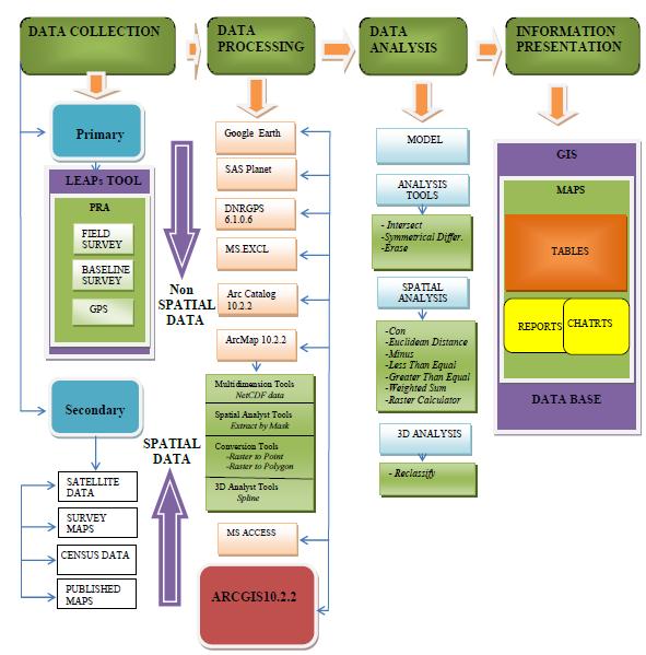
18 Ali, A 2009.Current Status of GIS in the Sudan
19 The lack of community and stakeholder participation in decision making and limited accountability of institutions of government are phenomena in Sudan. They are factors that cause policy failure. El Harizi et al (2007) found in their discussion Paper about Understanding Policy Volatility in Sudan, that the lack of participation in decision making result in poor generation of information and less interest of stakeholder which is often lead to policy failure.

20 El Harizi, K, Zaki, E, Prato, B,Shields, G 2007.IFPRI Discussion Paper Understanding Policy Volatility in Sudan
21 Lack of the participation of community and stockholders in decision making results in the inadequate acquisition of information, which is the reason for the failure of most polices in Sudan, including livelihood development planning. Lack of geospatial data in Sudan is one of the problems that prevents a full implementation of GIS in economic development planning and consumption of natural resources. Most rural development planning in Sudan is prepared in urban centers outside the affected villages and imposed upon those communities without knowledge of village realities. * * Interview with the Executive Officer, Mohamed O.M.Ahmed (Sudan National council for strategic planning), 14.August
22 What is the livelihoods situation for the villages in the study area given the social, livelihoods, resource maps, traded-in tradedout, income and expenditures patterns, genders, local markets, the emerging opportunity in wider markets, institutional analyses, and others as seen by GIS?
23 How can the GIS transform local knowledge from a study area into better polices for livelihoods enhancement planning at the regional and national levels? Given a participatory approach, how do we integrate data about the livelihoods, the social, the extent of poverty, and the availability of resources with geographical data? How do we build the livelihoods plan and map the plan onto the GIS? How do we see progress using GIS
24 The Study area The case study of the research has been carried out in the three villages of Alosylat region, Alhoyla village, Algwaz village, and Alhsnab village of Shareg Alnil locality in Khartoum state of Sudan

25 Map of Khartoum state (Source. Sudan Ministry of Federal Health 2004)

26 Map of Alosylat region (Source Nokia Ovi Maps 2016 )
27 1. THE TWO STEP DATA COLLECTION PROCESS A. Primary data The collection of the primary data (non-special data) have been completed by using the LEAP tool which is use the Participatory Rural Approach or PRA These participatory tools include group discussion, semi-structured interviews and transect walks to collect data, observing, asking, listening, looking and identifying zones. By walking the field, spatial data such as land use, settlement pattern and people s perception of these investigated and discussed in detail. The villager used markers to draw on large sheets of paper colored markers used to identify different aspects of the map. If villagers were unfamiliar with the use of writing instruments, they can draw maps on the ground with a stick. The Global Positioning System (GPS) applied data derived from the PRA stage for validation and accuracy of information gathered in regards to locating service centers, housing units, digitizing road networks, and obtaining precision points for geocoding satellite images. B. Secondary data Satellite data generated by Google Earth, free datasets portals and DG sat free satellites will be used to collect secondary data (special data), in addition to the survey maps, census data published by the Sudan National Survey Authority, Khartoum Federal Ministry of Health and Statistics Authority.
28 2. DATA PROCESSING After collecting primary and secondary data, some computer used to process the data. The spatial knowledge of the people presented in the form of layer maps and supplemented by Geospatial or map based information management tools, ranging from sketch maps, aerial photographs, satellite imagery, the Global Positioning System (GPS). The data processing software programs are Google Earth, Microsoft Excel, Microsoft Access, ArcMAP , ARC Catalog , and SASPlanet 3. DATA ANALYSIS After data was processed and stored in ArcGIS as spatial data, the ArcGIS analysis tool used for data analysis. 4. INFORMATION PRESENTATION ArcGIS presented the spatial knowledge of the people in the form of layers maps.
29
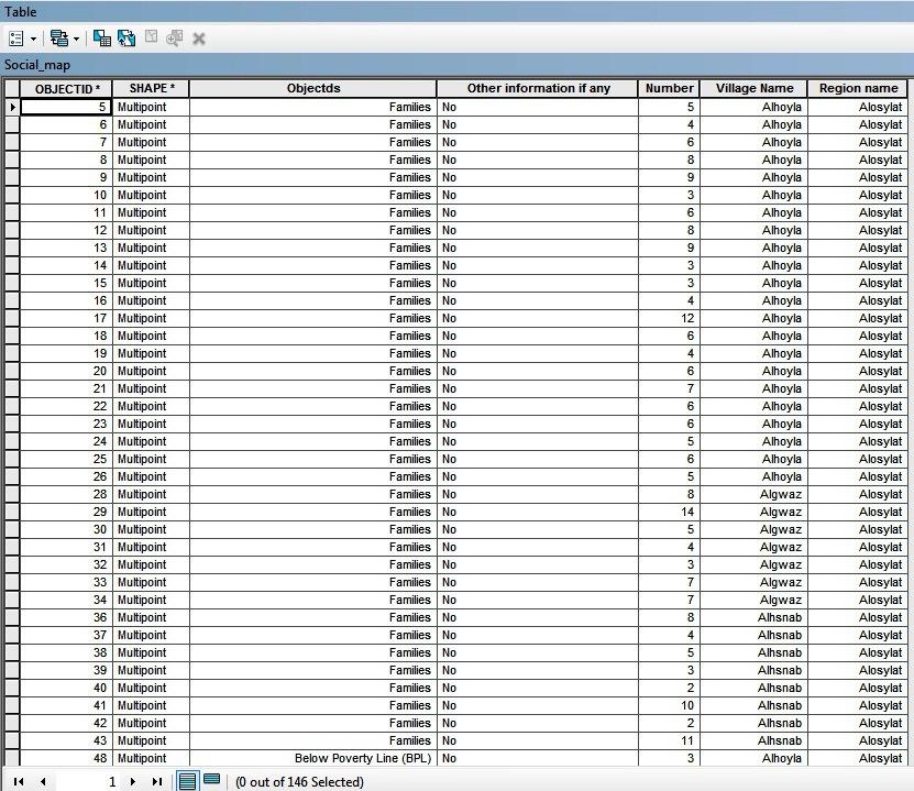
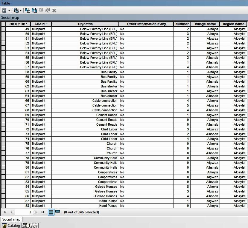
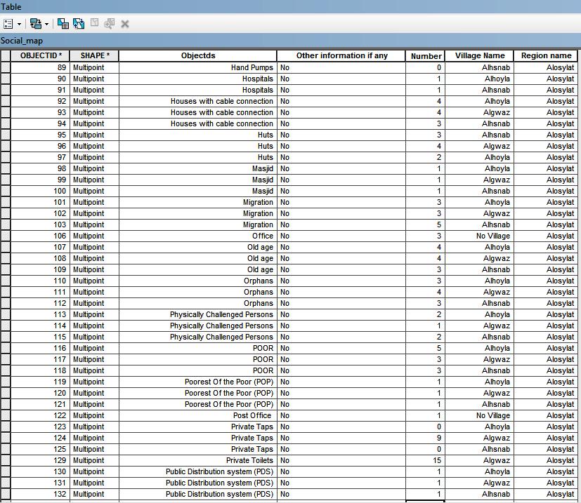
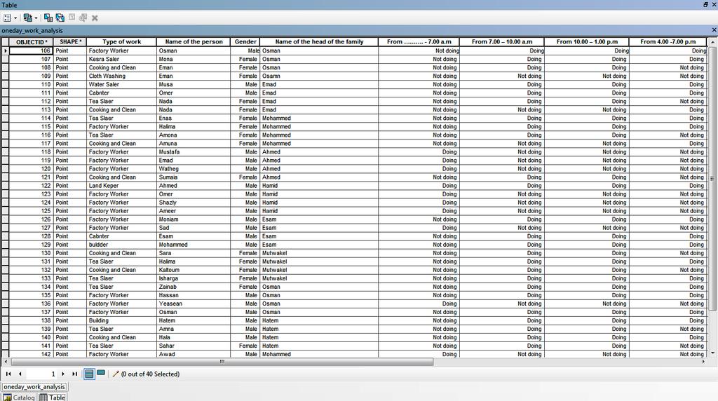
30 Social Map The social map enables the user to gain understanding about social status for the three villages. By using GIS which integrated all the social information s for the three villages and stored it to one geodatabase system and layers as show in attribute table below and map. This will help planning and decision making users who use the system to quarrying, analysing, and visualizing object on geo-referencing(gps) map, for the three villages together in purpose to understanding of the situation before plan or manage activities
31
32
33
34

35 Social Analysis

36 The Social Map
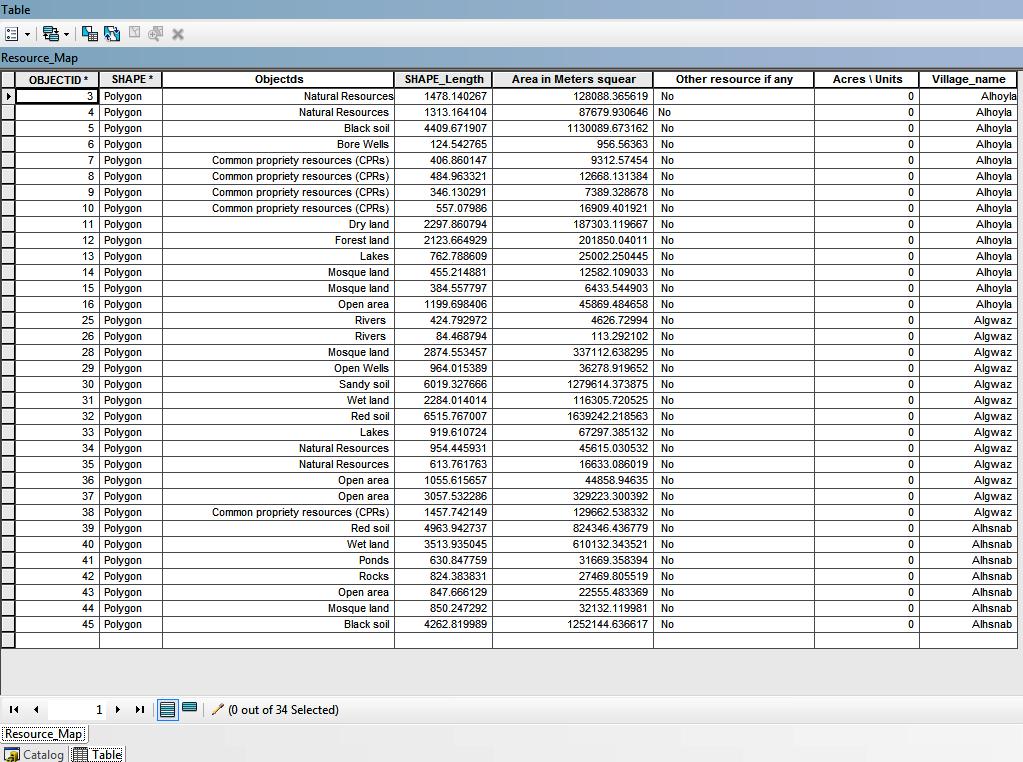
37 Resources Map Analysis The resource map identifies the location of natural resources in the village and their distribution. Using GIS, which integrated all the natural resources information s for the three villages and stored it to one geodatabase system and layers as show in the attribute table below and Map, will help planning and decision making users who use the system to quarry, analyze, and visualize objects on the geo-referencing (GPS) map for the three villages together to understand the situation of natural resources before plan or manage activities.
38

39 The resource map
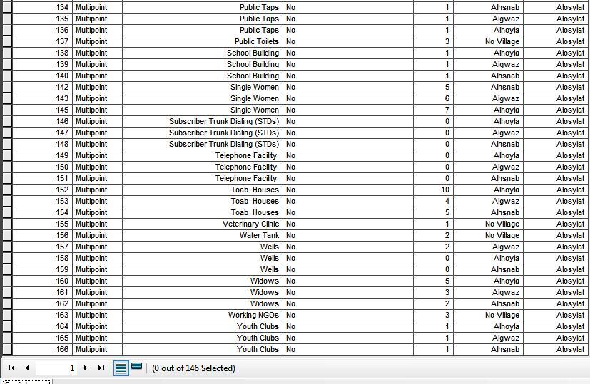
40 Livelihoods Map Analysis The livelihoods maps enable the community to identify the major vocations and the areas in which these vocations need additional support. Using GIS which integrated all the livelihoods information s for the three villages and stored it to one geodatabase system and layers as show in attribute table below and Map,will help planning and decision making users who use the system to quarry, analysing, and visualizing object on georeferencing(gps) map for the three villages together, in purpose to understanding the situation of livelihoods before plan or manage activities.

41

42 Results and Discussion Livelihoods Map
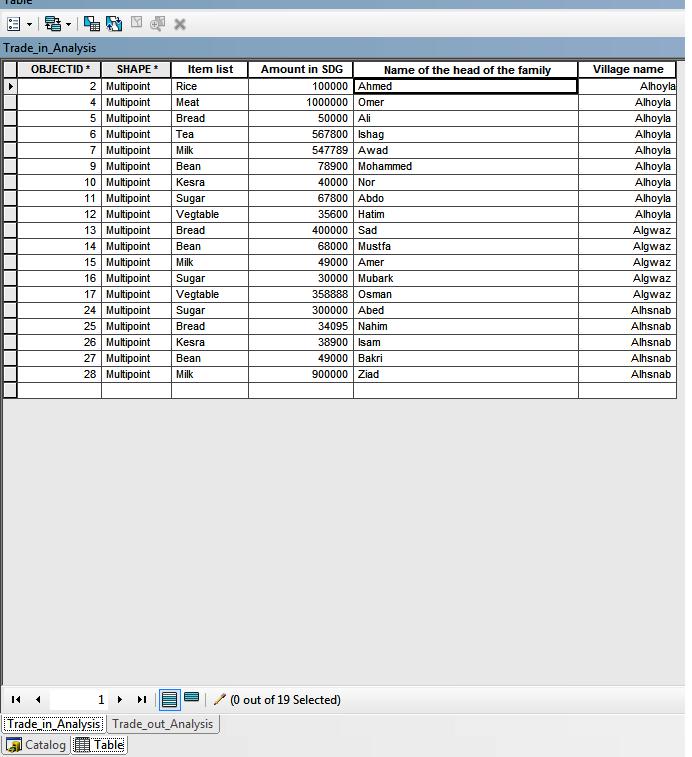
43 Trade-In and Trade-Out Analysis (Wages bring money into the village and wage\ work taking money out of the village) Trade-in and trade-out analysis outlines the flow of commodities and services in and out of the village. Using GIS, which integrated all the trade-in and trade-out for the three villages and stored it to one geo database system and layers as show in attribute table below and Map, will help planning and decision making users who use the system to quarry, analyze, and visualize objects on georeferencing (GPS) map for the three villages together for the purpose of understanding the flow of commodities and services in and out of a village before planning or managing activities.
44
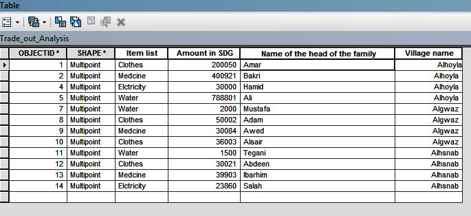
45
46 Results and Discussion Trade-In and Trade-Out map
47 Vulnerability Analysis The vulnerability analysis depicts a profile of the vulnerable people in the village. It aims to depict the risks and dangers faced by the village and coping mechanisms people use in risk management. Using GIS which integrated all the vulnerable people information s and coping mechanisms for the three villages and stored it to one geo database system and layers as shown in the attribute table below and Map, will help planning and decision making users who use the system to quarry, analyze, and visualize objects on geo referencing (GPS) map for the three villages together, for the purpose of understanding the situation of vulnerable people and coping mechanisms they use for risk management before planning or managing activates.
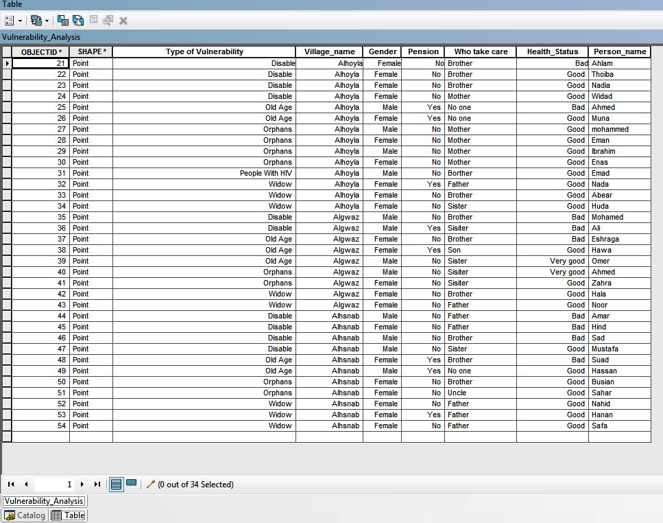
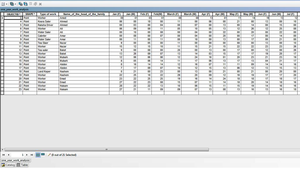
48
49 Vulnerability map
50 Income and Expenditure Analysis (3 Different Types of Poor Families) The income and expenditure analysis reveals the vulnerabilities of a household as well as its coping mechanisms. Using GIS, which integrated all the Income and Expenditure for three different types of poor families from the three villages and stored it to one geo database system and layers as show in attribute table below and Map will help planning and decision making users who use the system to quarry, analyze, and visualize objects on geo-referencing (GPS) map for the three villages together to understand the situation of vulnerable people and coping mechanisms they use for risk management before planning or managing activities

51
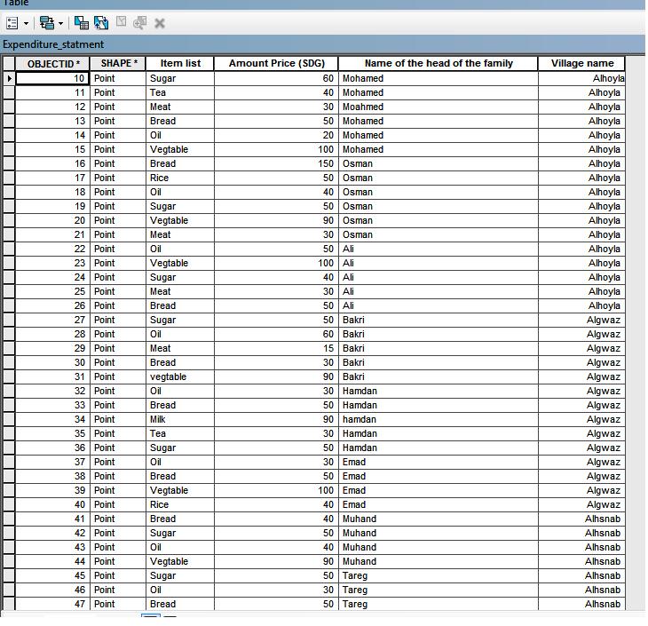
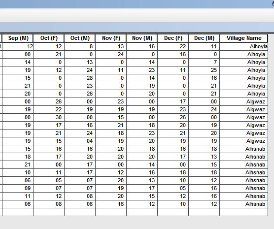
52

53 Income and Expenditure map
54 The market analysis (Local Opportunity Analysis) pinpoints products and services that come in to and out of the market and opportunities for employment. Using GIS, which integrated all the Local Opportunity for the three villages and stored it to one geodatabase system and layers as show in the attribute table below and Map, will help planning and decision making users who use the system to quarry, analyze, and visualize objects on the geo-referencing (GPS) map or the three villages together to understand the situation of local opportunity in the villages before planning or managing activities.
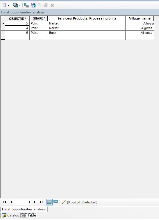
55

56 market analysis (Local Opportunity Analysis)
57 24-Hour Analysis (3 Different Types of Poor Families) The 24-hour analysis shows the activities in which a household engages within 24 hours period. Using GIS, which integrates all the 24-hours activities for three different types of poor families from the three villages and storing it to one geodatabase system and layers, as shown in the attribute table below and Map, will help planning and decision making users who use the system to quarry, analyze, and visualize objects on the geo-referencing (GPS) map for the three villages together to understand the conditions of 24-hours activities before planning or managing activities.
58

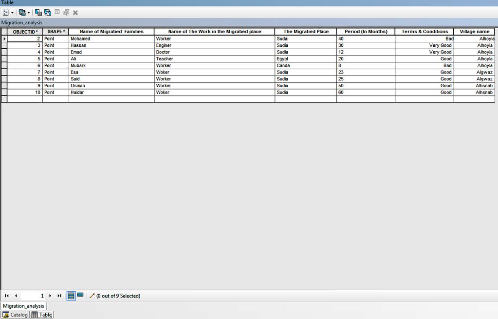
59
60 24-Hour Analysis map
61 365-Day Analysis The 365-day analysis singles out the number of days of activities in which a household engages (male and female) within the time frame of a year. Using GIS, which will integrates the total number of days of activities for one year for the three different types of poor families from the three villages and will store it to one geo database system and layers, as show in the attribute table below and Map, will help planners and decision- making users who use the system to system to quarry, analyze, and visualize objects on the georeferencing (GPS) map for the three villages together. It will enable the them to understand the condition of the number of days of activities for a year can affect the village before planning or managing activities begins.
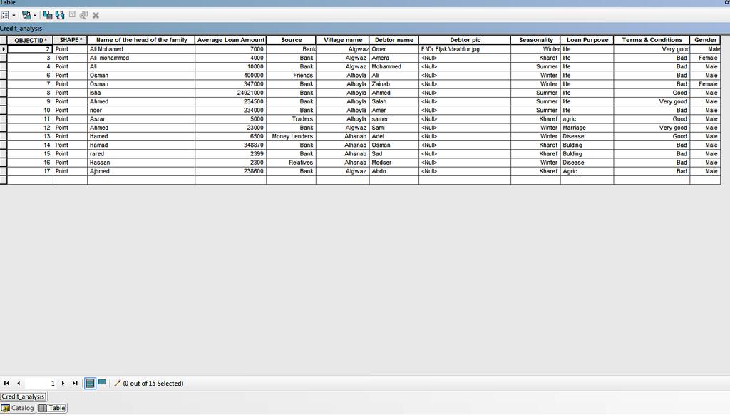
62
63

64 The 365-day analysis map
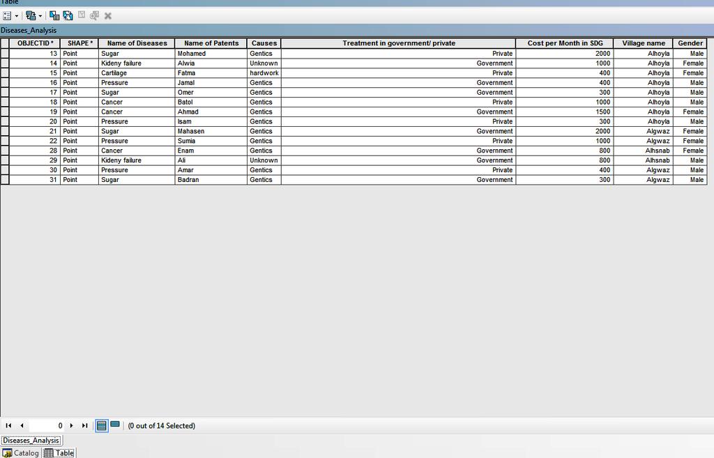
65 Seasonality Analysis The seasonality analysis identifies various factors that affect village life i.e. providing or denying credit, employment, immigration, migration, diseases and festivals. Using GIS, which integrated all the factors that affect the seasonality for the three villages and stored it to one geo database system and layers as shown in the attribute table below and Map, will help planners and decision-making users who use the system to quarry, analyze, and visualize objects on the geo-referencing (GPS) map for the three villages together. It will enable them to understand the conditions that seasonality as well as other various factors that affect the village before planning or managing activities begins.
66
67 Seasonality Analysis
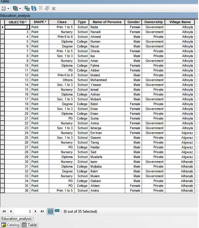
68 Migration Analysis The migration analysis examines the places where villagers migrate and the type of livelihoods they pursue. Using GIS which integrated all the Migration Analysis for the three villages and stored it to one geo database system and layers as shown in the attribute table below and Map, will help planners and decision making users who use the system to quarry, analyze, and visualize objects on the geo-referencing (GPS) map for the three villages together. It will enable the researcher to understand the condition of various factors that affect the village before planning or managing activities begins.
69

70 Migration Analysis map
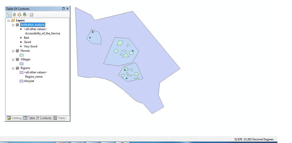
71 Credit Mapping Analysis Credit mapping indicates the reasons for, the source of, and amount of loans. Using GIS, which integrated all the credit analysis for the three villages and stored it to one geo database system and layers as shown in the attribute table below and Map, will help planners and decisionmaking users who use the system to quarry, analyze, and visualize objects on the geo-referencing (GPS) map for the three villages together. It will enable them to understand the conditions that impact credit as well as other various factors that affect the village before planning or managing activities begins.
72
73 Credit Mapping Analysis
74 Health/Disease Analysis The health/disease analysis shares the results of the health profile of the village. Using GIS, which integrated all the disease analysis for the three villages and stored it to one geo database system and layers as shown in the attribute table below and Map, will help planners and decision-making users who use the system to quarry, analyze, and visualize objects on the geo-referencing (GPS) map for the three villages together. It will enable them to understand the conditions that impact health as well as other various factors that affect the village before planning or managing activities begins.
75
76 Health/Disease Analysis map
77 Education analysis The education analysis portrays the education profile of the village. Using GIS which integrated all the education analysis for the three villages and stored it to one geo database system and layers as show in the attribute table and Map, will help planners and decisionmaking users who use the system to quarry, analyze, and visualize objects on the geo-referencing (GPS) map for the three villages together. It will enable the researcher to understand the impact of education as well as other various factors that affect the village before planning or managing activities begins.
78

79 Education analysis map
80 Institutional Analysis The institutional analysis presents data collected on all formal and informal organizations, youth groups, government units, NGOs and others and opportunities to access their services. Using GIS, which integrated all the Institutional for the three villages and stored it to one geodatabase system and layers as show in the attribute table below and Map, will help planners and decision-making users who use the system to quarry, analyze, and visualize objects on the geo-referencing (GPS) map for the three villages together. It will enable the researcher to understand the impact of institutions as well as other various factors that affect the village before planning or managing activities begins.

81
82 Institutional Analysis map
83 Enterprise Mapping Analysis Enterprise mapping records the existing enterprises, their issues and scope for more enterprises or improvements in the existing ones. Using GIS, which integrated all the existing enterprises for the three villages and stored it to one geodatabase system and layers as show in the attribute table below and Map, will help planners and decision-making users who use the system to quarry, analyze, and visualize objects on the geo-referencing (GPS) map for the three villages together. It will enable the researcher to understand the impact of existing enterprises as well as other various factors that affect the village before planning or managing activities begins.
84 Education and Health Ranking Analysis The education and health-ranking tool helps to rank status of availability of education and health services in any village/location. Using GIS, which will integrate all the Education and Health Ranking for the three villages and stored it to one geo database system and layers as show in the attribute table below and Maps, will help planners and decision-making users who use the system to quarry, analyze, and visualize objects on the georeferencing (GPS) map for the three villages together. It will enable the researcher to see the impact of health services and education as well as other various factors that affect the village before planning or managing activities begins.
85
86 Health Ranking Analysis map

87 Education Ranking Analysis map
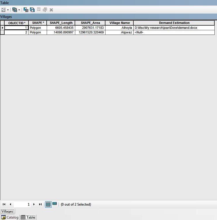
88 Demand Estimation Analysis Demand estimation for a product will include the cumulative demand for the product/service in the market. Using GIS, which integrated all of the demand estimation for a product for the three villages and stored it to one geo database system and layers as show in the attribute table below will help planners and decision-making users who use the system to quarry, analyze, and visualize objects on the georeferencing (GPS) map for the three villages together. It will enable the researcher to understand the impact the cumulative demand for the product/service in the market as well as other various factors that affect the village before planning or managing activities begins.
89
90 19.Climate Change Analysis The climate change analysis tool is used by the GIS to predict and quantify the impact of changing perception and increasing temperature on livelihoods that depend on the vegetation in the study areas (up to 2050). Maps below show that the study area of the Alosylat region is out of the affected zone of climate change predicted for Sudan in 2050, and its livelihood (natural vegetation and cultivated land) depends whether it falls on the safe side of climate change. The data is used in this research to predict and quantify the impacts of changing perception and increasing temperature on livelihoods (up to 2050) in the study areas that depend on vegetation is real data from the free datasets portals ESGF

91 Climate Change Analysis map

92 Climate Change Analysis map
93 The findings of this study will benefit society because bottom-up planning plays an important role in the success of the policy. This process can be used in addition to village and micro level planning systems as well as planning at the regional and national levels. The greater demand for Electronic Governance (E-Governance) in Sudan justifies the need for research of GIS. Local level planners, development practitioners and government officials that apply the recommended approach derived from the results of this study will be able to enhance their plan and decision making for livelihoods development. The study will eliminate gaps in knowledge in livelihoods development by integrating information of the LEAP tool with participatory GIS. This study will help other researchers to use the same approach to cover additional regions in Sudan. (The system has the potential to store unlimited villages numbers). The same study may be used to establish a web-gis
94 Akshara Network How to do LEAP [online]. Available from ad/91-supplement-how-to-do-leap-august-2012 [accessed 29 August 2012]. Ali, A 2009.Current Status of GIS in the Sudan. Paper presented to the Eighteenth United Nations Regional Cartographic Conference for Asia and the Pacific, Bangkok, October 2009, Available from UNRCCAP_econf.100_crp%2010.pdf [accessed 5 May 2015].
95 El Harizi, K, Zaki, E, Prato, B,Shields, G 2007.IFPRI Discussion Paper Understanding Policy Volatility in Sudan [online] Available from [accessed 5 Nov2016]. Quan, J, Oudwate, N, Pender, J and Martin,A GIS And Participatory Approaches In Natural Resources Research. In Quan, J, Oudwate, N, Pender, J and Martin,A (ed), GIS And Participatory Approaches In Natural Resources Research. Socio-Economic Methodologies For Natural Resources Research. Best Practice Guidelines. Oxon: Natural Resources Institute, Web. 16 Nov Scoones, I Sustainable rural livelihoods and rural development. UK: Practical Action Publishing and Winnipeg, CA: Fernwood Publishing Scoones, I Sustainable rural livelihoods: a framework for analysis. IDS Working Paper 72. Brighton: Institute for Development Studies. Available from [accessed October2016]. World bank Important Segments of the LEAP Processes [online]. Available from 23 Jun 2016].
96 Questions
Geospatial Technologies for Resources Planning & Management
 Geospatial Technologies for Resources Planning & Management Lal Samarakoon, PhD Director, Geoinformatics Center Asian Institute of Technology, Thailand Content Geoinformatics for SDG Information Integration
National Disaster Management Centre (NDMC) Republic of Maldives. Location
 Republic of Maldives. Location") National Disaster Management Centre (NDMC) Republic of Maldives Location Country Profile 1,190 islands. 198 Inhabited Islands. Total land area 300 sq km Islands range b/w 0.2 5 sq km Population approx.
National Disaster Management Centre (NDMC) Republic of Maldives Location Country Profile 1,190 islands. 198 Inhabited Islands. Total land area 300 sq km Islands range b/w 0.2 5 sq km Population approx.
Brazil Paper for the. Second Preparatory Meeting of the Proposed United Nations Committee of Experts on Global Geographic Information Management
 Brazil Paper for the Second Preparatory Meeting of the Proposed United Nations Committee of Experts on Global Geographic Information Management on Data Integration Introduction The quick development of
Presented to Sub-regional workshop on integration of administrative data, big data and geospatial information for the compilation of SDG indicators
 Presented to Sub-regional workshop on integration of administrative data, big data and geospatial information for the compilation of SDG indicators 23-25 April,2018 Addis Ababa, Ethiopia By: Deogratius
RETA 6422: Mainstreaming Environment for Poverty Reduction Category 2 Subproject
 RETA 6422: Mainstreaming Environment for Poverty Reduction Category 2 Subproject A. Basic Data 1. Subproject Title: Poverty-Environment Mapping to Support Decision Making 2. Country Director: Adrian Ruthenberg
CENSUS MAPPING WITH GIS IN NAMIBIA. BY Mrs. Ottilie Mwazi Central Bureau of Statistics Tel: October 2007
 CENSUS MAPPING WITH GIS IN NAMIBIA BY Mrs. Ottilie Mwazi Central Bureau of Statistics E-mail: omwazi@npc.gov.na Tel: + 264 61 283 4060 October 2007 Content of Presentation HISTORICAL BACKGROUND OF CENSUS
GEOGRAPHIC INFORMATION SYSTEMS Session 8
 GEOGRAPHIC INFORMATION SYSTEMS Session 8 Introduction Geography underpins all activities associated with a census Census geography is essential to plan and manage fieldwork as well as to report results
How GIS based Visualizations Support Land Use and Transportation Modeling
 How GIS based Visualizations Support Land Use and Transportation Modeling ESRI International Users Conference San Diego, CA - July 23, 2015 Prepared by: Troy Hightower Introduction This presentation will
Public Disclosure Copy. Implementation Status & Results Report KH - Livelihood Enhancement and Association of the Poor Project (LEAP) (P153591)
 (P153591)") Public Disclosure Authorized EAST ASIA AND PACIFIC Cambodia Agriculture Global Practice IBRD/IDA Investment Project Financing FY 2017 Seq No: 1 ARCHIVED on 17-Jun-2017 ISR28362 Implementing Agencies: Ministry
Public Disclosure Authorized EAST ASIA AND PACIFIC Cambodia Agriculture Global Practice IBRD/IDA Investment Project Financing FY 2017 Seq No: 1 ARCHIVED on 17-Jun-2017 ISR28362 Implementing Agencies: Ministry
Minnesota K-12 Academic Standards in Social Studies. Grade 4: Geography of North America
 Minnesota K-12 Academic s in Social Studies Grade 4: Geography of North America 4 Describe how people take 1. Democratic government action to influence a depends on informed and decision on a specific
Creating a Staff Development Plan with Esri
 Creating a Staff Development Plan with Esri Michael Green David Schneider Guest Presenter: Shane Feirer, University of California Esri UC 2014 Technical Workshop Agenda What is a Staff Development Plan?
Georeferencing and Satellite Image Support: Lessons learned, Challenges and Opportunities
 Georeferencing and Satellite Image Support: Lessons learned, Challenges and Opportunities Shirish Ravan shirish.ravan@unoosa.org UN-SPIDER United Nations Office for Outer Space Affairs (UNOOSA) UN-SPIDER
Integration for Informed Decision Making
 Geospatial and Statistics Policy Intervention: Integration for Informed Decision Making Greg Scott Global Geospatial Information Management United Nations Statistics Division Department of Economic and
Use of Geospatial Data: Philippine Statistics Authority 1
 Use of Geospatial Data: Philippine Statistics Authority 1 1 Presentation by Lisa Grace S. Bersales at the UNSC 2016 side event on Geospatial information and earth observations: supporting official statistics
The Role of the Louisiana Geographic Information Center in the Response to Hurricane Katrina
 The Role of the Louisiana Geographic Information Center in the Response to Hurricane Katrina By: Jared Chapiewsky & Laura Brown For: URPL 969- GIS Applications in Response to Hurricane Katrina Date: March
GIS = Geographic Information Systems;
 What is GIS GIS = Geographic Information Systems; What Information are we talking about? Information about anything that has a place (e.g. locations of features, address of people) on Earth s surface,
Realizing benefits of Spatial Data Infrastructure A user s perspective from Environment Agency - Abu Dhabi
 Realizing benefits of Spatial Data Infrastructure A user s perspective from Environment Agency - Abu Dhabi Anil Kumar Director, Environment Information Management 26 April 2012 Geospatial World Forum,
CHAPTER 22 GEOGRAPHIC INFORMATION SYSTEMS
 CHAPTER 22 GEOGRAPHIC INFORMATION SYSTEMS PURPOSE: This chapter establishes the administration and use of to improve the quality and accessibility of Department s spatial information and support graphical
Country Report on SDI Activities in Singapore *
 UNITED NATIONS E/CONF.100/CRP.9 ECONOMIC AND SOCIAL COUNCIL Eighteenth United Nations Regional Cartographic Conference for Asia and the Pacific Bangkok, 26-29 October 2009 Item 7(a) of the provisional
Section III: Poverty Mapping Results
 Section III: Poverty Mapping Results Figure 5: Gewog level rural poverty map 58. The most prominent result from the poverty mapping exercise of Bhutan is the production of a disaggregated poverty headcount
Challenges and Potentials of Place Based Information Management in Nepal"
 Nineteenth United Nations Regional Cartographic Conference for Asia and the Pacific, Bangkok, Thailand, 29 October 1 November 2012 Challenges and Potentials of Place Based Information Management in Nepal"
file://q:\report1\greenatlasfinalreportindex.html
 Page 1 of 8 Quick Links WATER MANAGEMENT INTERNSHIP USDA HIS GRANT FUNDED FINAL PROJECT REPORT SUBMITTED BY MELISSA QUINTANA 11/07/07-03/24/08 Summary Provided is an assessment of my accomplishments for
Techniques for Science Teachers: Using GIS in Science Classrooms.
 Techniques for Science Teachers: Using GIS in Science Classrooms. After ESRI, 2008 GIS A Geographic Information System A collection of computer hardware, software, and geographic data used together for
Towards Reliable Spatial Database of Informal Areas in Greater Cairo Region
 KEYWORDS informal areas, unreliable spatial data, spatial data collecting, capacity building SUMMARY The uncontrolled and rapid increase of Egypt s cities is a major problem of the country. More than the
The Integrated Ge spatial Information Framework to the strengthening of NSDI, Mongolia
 Young Geospatial Professionals Summit 21 NOV 2018 The Integrated Ge spatial Information Framework to the strengthening of NSDI, Mongolia BAYARMAA ENKHTUR Geospatial information and technology department
The World Bank Community Development Program Support Project-Phase III (P144637)
") Public Disclosure Authorized AFRICA Cameroon Social, Urban, Rural and Resilience Global Practice Global Practice IBRD/IDA Investment Project Financing FY 2016 Seq No: 5 ARCHIVED on 21-Dec-2017 ISR30226
Public Disclosure Authorized AFRICA Cameroon Social, Urban, Rural and Resilience Global Practice Global Practice IBRD/IDA Investment Project Financing FY 2016 Seq No: 5 ARCHIVED on 21-Dec-2017 ISR30226
Overview of Technical Advisory Missions
 Expert Group Meeting (EGM) on Georeferenced Information Systems for Disaster Risk Management (Geo-DRM) and sustaining the Community of Practice (COP) 23-25 April 2014 Bangkok Overview of Technical Advisory
The Efforts of Building GIS Infrastructure in a Newly Independent State: The case of Timor Leste *
 UNITED NATIONS E/CONF.100/IP.12 ECONOMIC AND SOCIAL COUNCIL Eighteenth United Nations Regional Cartographic Conference for Asia and the Pacific Bangkok, 26-29 October 2009 Item 7(b) of the provisional
Spatially Enabled Society
 International Seminar on Land Administration Trends and Issues in Asia and the Pacific Region Spatially Enabled Society Abbas Rajabifard Vice Chair PCGIAP-WG3 Vice-President (President Elect), GSDI Association
Key Indicators for Territorial Cohesion and Spatial Planning in Preparing Territorial Development Strategies
 ESPON Evidence in a North European Context Challenges and Opportunities for Territorial Development and Cohesion in a North European Macro Region, 10-11 April, 2014, Vilnius, Lithuania Key Indicators for
Implementing the Sustainable Development Goals: The Role of Geospatial Technology and Innovation
 Fifth High Level Forum on UN Global Geospatial Information Management Implementing the Sustainable Development Goals: The Role of Geospatial Technology and Innovation 28-30 November 2017 Sheraton Maria
Diverse Places 3 days
 AS Level Geography Edexcel Diverse Places 3 days Deliver two days of fieldwork within a dynamic human environment and cover the recommended themes in depth. Fieldwork in these locations provides a contrast
National Cartographic Center
 National Cartographic Center NCC activities and accomplishments Activities of national organizations, institutions and universities in field of geomatics Large scale maps Medium scale maps Small scale
Geography. Geography A. Curriculum Planner and Skills Mapping Grid GCSE Version 1 October 2012
 Geography GCSE 2012 Geography A Curriculum Planner and Skills Mapping Grid Version 1 October 2012 www.ocr.org.uk/gcse2012 Year 10 Exam work Controlled Assessment Autumn 1 Autumn 2 Spring 1 Spring 2 Summer
The World Bank Decentralized Community Driven Services Project (P117764)
") Public Disclosure Authorized AFRICA Benin Social Protection Global Practice IBRD/IDA Adaptable Program Loan FY 2012 Seq No: 6 ARCHIVED on 12-Jun-2015 ISR19748 Implementing Agencies: Public Disclosure Authorized
Public Disclosure Authorized AFRICA Benin Social Protection Global Practice IBRD/IDA Adaptable Program Loan FY 2012 Seq No: 6 ARCHIVED on 12-Jun-2015 ISR19748 Implementing Agencies: Public Disclosure Authorized
ABSTRACT I. INTRODUCTION II. OBJECTIVES
 2017 IJSRSET Volume 3 Issue 1 Print ISSN: 2395-1990 Online ISSN : 2394-4099 Themed Section: Engineering and Technology GIS Based Urban Road Network Analysis in Khartoum Center Mohamed ElAmin Ahmed Babiker,
The World Bank Community Development Program Support Project-Phase III (P144637)
") Public Disclosure Authorized AFRICA Cameroon Social, Urban, Rural and Resilience Global Practice Global Practice IBRD/IDA Investment Project Financing FY 2016 Seq No: 4 ARCHIVED on 20-Jun-2017 ISR27942
Public Disclosure Authorized AFRICA Cameroon Social, Urban, Rural and Resilience Global Practice Global Practice IBRD/IDA Investment Project Financing FY 2016 Seq No: 4 ARCHIVED on 20-Jun-2017 ISR27942
Public Disclosure Copy. Social Inclusion and Improvement of Livelihoods of Youth, Vulnerable Women and Handicapped in Post
 Public Disclosure Authorized Social Inclusion and Improvement of Livelihoods of Youth, Vulnerable Women and Handicapped in Post Conflict AFRICA Cote d'ivoire Social, Urban, Rural and Resilience Global
Urban Climate Resilience
 Urban Climate Resilience in Southeast Asia Partnership Project Introduction Planning for climate change is a daunting challenge for governments in the Mekong Region. Limited capacity at the municipal level,
Merging statistics and geospatial information
 Merging statistics and geospatial information Demography / Commuting / Spatial planning / Registers Mirosław Migacz Chief GIS Specialist Janusz Dygaszewicz Director Central Statistical Office of Poland
The World Bank Community Development Program Support Project-Phase III (P144637)
") Public Disclosure Authorized AFRICA Cameroon Social, Urban, Rural and Resilience Global Practice Global Practice IBRD/IDA Investment Project Financing FY 2016 Seq No: 6 ARCHIVED on 27-Jun-2018 ISR33107
Public Disclosure Authorized AFRICA Cameroon Social, Urban, Rural and Resilience Global Practice Global Practice IBRD/IDA Investment Project Financing FY 2016 Seq No: 6 ARCHIVED on 27-Jun-2018 ISR33107
Measuring Disaster Risk for Urban areas in Asia-Pacific
 Measuring Disaster Risk for Urban areas in Asia-Pacific Acknowledgement: Trevor Clifford, Intl Consultant 1 SDG 11 Make cities and human settlements inclusive, safe, resilient and sustainable 11.1: By
The World Bank CG Rep. LISUNGI Safety Nets System Project (P145263)
") Public Disclosure Authorized AFRICA Congo, Republic of Social Protection & Labor Global Practice IBRD/IDA Investment Project Financing FY 2014 Seq No: 7 ARCHIVED on 04-Dec-2017 ISR30246 Implementing Agencies:
Public Disclosure Authorized AFRICA Congo, Republic of Social Protection & Labor Global Practice IBRD/IDA Investment Project Financing FY 2014 Seq No: 7 ARCHIVED on 04-Dec-2017 ISR30246 Implementing Agencies:
Concept note. High-Level Seminar: Accelerating Sustainable Energy for All in Landlocked Developing Countries through Innovative Partnerships
 Concept note High-Level Seminar: Accelerating Sustainable Energy for All in Landlocked Developing Countries through Innovative Partnerships Date: 24 and 25 October 2016 Venue: Conference Room C3, Vienna
European Regional and Urban Statistics
 European Regional and Urban Statistics Dr. Berthold Feldmann berthold.feldmann@ec.europa.eu Eurostat Structure of the talk Regional statistics in the EU The tasks of Eurostat Regional statistics Urban
Weather Climate Science to Service Partnership South Africa
 PROJECTS UNDERWAY Title of the Weather Climate Science to Service Partnership South Africa Together, building on an existing strong partnership, South African Weather Service and the Met Office will build
Public Disclosure Copy
 Public Disclosure Authorized SOUTH ASIA Nepal Agriculture Global Practice IBRD/IDA Investment Project Financing FY 2008 Seq No: 23 ARCHIVED on 26-Jul-2018 ISR33099 Implementing Agencies: Poverty Alleviation
Understanding China Census Data with GIS By Shuming Bao and Susan Haynie China Data Center, University of Michigan
 Understanding China Census Data with GIS By Shuming Bao and Susan Haynie China Data Center, University of Michigan The Census data for China provides comprehensive demographic and business information
Geospatial SDI Portal for effective Governance of Pune METROPOLIS region
 Geospatial SDI Portal for effective Governance of Pune METROPOLIS region Mr. Praveen Gautam Senior Manager 19 th January 2018 PMRDA Overview Provide a Spatial Framework for the entire region with various
INDIANA ACADEMIC STANDARDS FOR SOCIAL STUDIES, WORLD GEOGRAPHY. PAGE(S) WHERE TAUGHT (If submission is not a book, cite appropriate location(s))
 WHERE TAUGHT (If submission is not a book, cite appropriate location(s))") Prentice Hall: The Cultural Landscape, An Introduction to Human Geography 2002 Indiana Academic Standards for Social Studies, World Geography (Grades 9-12) STANDARD 1: THE WORLD IN SPATIAL TERMS Students
Prentice Hall: The Cultural Landscape, An Introduction to Human Geography 2002 Indiana Academic Standards for Social Studies, World Geography (Grades 9-12) STANDARD 1: THE WORLD IN SPATIAL TERMS Students
Finding Common Ground Through GIS
 Finding Common Ground Through GIS Matthew Stone, MPH Special Unit for Technical Assistance Chronic Disease and Injury Control California Department of Public Health ESRI Health GIS Conference Scottsdale,
GEOGRAPHIC INFORMATION SYSTEMS
 GEOGRAPHIC INFORMATION SYSTEMS 4-H Round-Up Community Transitions Workshop Daniel Hanselka June 14, 2011 Goals of the Workshop Answer the question: What is GIS? Uses of GIS. Some of the Common Terminology
Journey of supporting CSNs to establish Geo-DRM
 Regional Workshop on Geo-referenced Information Systems for Disaster Risk Management (Geo-DRM) 26-27 June 2014 Bangkok, Thailand Journey of supporting CSNs to establish Geo-DRM Keran Wang Chief, Space
Country Report On Sdi Activities In Singapore ( )
") UNITED NATIONS E/CONF.102/IP.4 ECONOMIC AND SOCIAL COUNCIL Nineteenth United Nations Regional Cartographic Conference for Asia and the Pacific Bangkok, 29 October 1 November 2012 Item 6(b) of the provisional
UNITED NATIONS E/CONF.102/IP.4 ECONOMIC AND SOCIAL COUNCIL Nineteenth United Nations Regional Cartographic Conference for Asia and the Pacific Bangkok, 29 October 1 November 2012 Item 6(b) of the provisional
GIS at UCAR. The evolution of NCAR s GIS Initiative. Olga Wilhelmi ESIG-NCAR Unidata Workshop 24 June, 2003
 GIS at UCAR The evolution of NCAR s GIS Initiative Olga Wilhelmi ESIG-NCAR Unidata Workshop 24 June, 2003 Why GIS? z z z z More questions about various climatological, meteorological, hydrological and
GIS Visualization: A Library s Pursuit Towards Creative and Innovative Research
 GIS Visualization: A Library s Pursuit Towards Creative and Innovative Research Justin B. Sorensen J. Willard Marriott Library University of Utah justin.sorensen@utah.edu Abstract As emerging technologies
MALDIVES. Regional Expert Workshop On Land Accounting For SDG Monitoring & Reporting (25-27 th Sept 2017) - Fathimath Shanna, Aishath Aniya -
 - Fathimath Shanna, Aishath Aniya -") MALDIVES Regional Expert Workshop On Land Accounting For SDG Monitoring & Reporting (25-27 th Sept 2017) - Fathimath Shanna, Aishath Aniya - ABOUT MALDIVES Approximately 860 km long and 120 km wide Consists
MALDIVES Regional Expert Workshop On Land Accounting For SDG Monitoring & Reporting (25-27 th Sept 2017) - Fathimath Shanna, Aishath Aniya - ABOUT MALDIVES Approximately 860 km long and 120 km wide Consists
Spatial Data Management of Bio Regional Assessments Phase 1 for Coal Seam Gas Challenges and Opportunities
 Spatial Data Management of Bio Regional Assessments Phase 1 for Coal Seam Gas Challenges and Opportunities By Dr Zaffar Sadiq Mohamed-Ghouse Principal Consultant, Spatial & IT, GHD zaffar.sadiq@ghd.com
Indicator: Proportion of the rural population who live within 2 km of an all-season road
 Goal: 9 Build resilient infrastructure, promote inclusive and sustainable industrialization and foster innovation Target: 9.1 Develop quality, reliable, sustainable and resilient infrastructure, including
Aboriginal communities strengthen governance with location-based tools in the 21st century
 Aboriginal communities strengthen governance with location-based tools in the 21st century Today, Aboriginal communities are taking advantage of the geomatics technologies that underpin popular online
Geography for the 2020 Round of Census
 Boundaries Key Census Data EA Id Population Male Female EA Id Area EA Id Num HH Avg HH size Geography for the 2020 Round of Census Linda Peters, Esri lpeters@esri.com Integration of Statistical and Geospatial
Public Disclosure Copy
 Public Disclosure Authorized SOUTH ASIA Nepal Agriculture Global Practice IBRD/IDA Investment Project Financing FY 2008 Seq No: 22 ARCHIVED on 27-Apr-2018 ISR32244 Implementing Agencies: Poverty Alleviation
The Emerging Role of Enterprise GIS in State Forest Agencies
 The Emerging Role of Enterprise GIS in State Forest Agencies Geographic Information System (GIS) A geographic information system (GIS) is a computer software system designed to capture, store, manipulate,
THE ROLE OF GEOSPATIAL AT THE WORLD BANK
 THE ROLE OF GEOSPATIAL AT THE WORLD BANK INSPIRE Conference Barcelona, Spain September 26, 2016 Kathrine Kelm Senior Land Administration Specialist Global Land and Geospatial Unit The World Bank Group
National Spatial Development Perspective (NSDP) Policy Coordination and Advisory Service
 Policy Coordination and Advisory Service") National Spatial Development Perspective (NSDP) Policy Coordination and Advisory Service 1 BACKGROUND The advances made in the First Decade by far supersede the weaknesses. Yet, if all indicators were
National Spatial Development Perspective (NSDP) Policy Coordination and Advisory Service 1 BACKGROUND The advances made in the First Decade by far supersede the weaknesses. Yet, if all indicators were
Measuring Poverty. Introduction
 Measuring Poverty Introduction To measure something, we need to provide answers to the following basic questions: 1. What are we going to measure? Poverty? So, what is poverty? 2. Who wants to measure
Public Participatory GIS (ppgis), training & webgis in Mare Nostrum. Anna Spiteri, IRMCo Haifa, Israel, 5th March 2013
, training & webgis in Mare Nostrum. Anna Spiteri, IRMCo Haifa, Israel, 5th March 2013") Public Participatory GIS (ppgis), training & webgis in Mare Nostrum Anna Spiteri, IRMCo Haifa, Israel, 5th March 2013 What is ppgis? Why do we need it? Who participates? Where do we do it? When do we do
Public Participatory GIS (ppgis), training & webgis in Mare Nostrum Anna Spiteri, IRMCo Haifa, Israel, 5th March 2013 What is ppgis? Why do we need it? Who participates? Where do we do it? When do we do
From PCGIAP to UN GGIM AP: A Regional Perspective on GGIM
 Regional Committee of United Nations Global Geospatial Information Management for Asia and the Pacific (UN-GGIM-AP) Established by a United Nations Resolution From PCGIAP to UN GGIM AP: A Regional Perspective
ESCAP Promotes Geo-referenced Information System for Disaster Risk Management in Asia and the Pacific
 Third High Level Forum on UNGGIM 22-24 October 2014 Beijing, China ESCAP Promotes Geo-referenced Information System for Disaster Risk Management in Asia and the Pacific Keran Wang Space Applications Section,
TOWARDS STRATEGIC SPATIAL PLANNING IN JAMAICA: THE NATIONAL SPATIAL PLAN
 TOWARDS STRATEGIC SPATIAL PLANNING IN JAMAICA: THE NATIONAL SPATIAL PLAN JIEP 5th Biennial Conference on the Environment: Balancing National Development and Environmental Protection June 6, 2011 Jamaica
Integrating Official Statistics and Geospatial Information NBS Experience
 Integrating Official Statistics and Geospatial Information NBS Experience Presented by Eng. Reda AL Sabbagh Director of IT Dept. Prepared by Eng. Adham Makky GIS Specialist Topics to be covered: Background
ECONOMIC AND SOCIAL COUNCIL 13 July 2007
 UNITED NATIONS E/CONF.98/CRP.34 ECONOMIC AND SOCIAL COUNCIL 13 July 2007 Ninth United Nations Conference on the Standardization of Geographical Names New York, 21-30 August 2007 Item 17(b) of the provisional
DATA DISAGGREGATION BY GEOGRAPHIC
 PROGRAM CYCLE ADS 201 Additional Help DATA DISAGGREGATION BY GEOGRAPHIC LOCATION Introduction This document provides supplemental guidance to ADS 201.3.5.7.G Indicator Disaggregation, and discusses concepts
Welcome to NR502 GIS Applications in Natural Resources. You can take this course for 1 or 2 credits. There is also an option for 3 credits.
 Welcome to NR502 GIS Applications in Natural Resources. You can take this course for 1 or 2 credits. There is also an option for 3 credits. The 1st credit consists of a series of readings, demonstration,
Belfairs Academy GEOGRAPHY Fundamentals Map
 YEAR 12 Fundamentals Unit 1 Contemporary Urban Places Urbanisation Urbanisation and its importance in human affairs. Global patterns of urbanisation since 1945. Urbanisation, suburbanisation, counter-urbanisation,
Compact guides GISCO. Geographic information system of the Commission
 Compact guides GISCO Geographic information system of the Commission What is GISCO? GISCO, the Geographic Information System of the COmmission, is a permanent service of Eurostat that fulfils the requirements
How GIS can be used for improvement of literacy and CE programmes
 How GIS can be used for improvement of literacy and CE programmes Training Workshop for Myanmar Literacy Resource Center (MLRC) ( Yangon, Myanmar, 11 20 October 2000 ) Presented by U THEIN HTUT GEOCOMP
Apéndice 1: Figuras y Tablas del Marco Teórico
 Apéndice 1: Figuras y Tablas del Marco Teórico FIGURA A.1.1 Manufacture poles and manufacture regions Poles: Share of employment in manufacture at least 12% and population of 250,000 or more. Regions:
Geography. Programme of study for key stage 3 and attainment target (This is an extract from The National Curriculum 2007)
") Geography Programme of study for key stage 3 and attainment target (This is an extract from The National Curriculum 2007) Crown copyright 2007 Qualifications and Curriculum Authority 2007 Curriculum aims
Geography Programme of study for key stage 3 and attainment target (This is an extract from The National Curriculum 2007) Crown copyright 2007 Qualifications and Curriculum Authority 2007 Curriculum aims
Climate Resilience Decision Making Framework in the Caribbean. A case of Spatial Data Management
 Climate Resilience Decision Making Framework in the Caribbean A case of Spatial Data Management Bishwa Pandey Sr. Data Management Specialist The World Bank Background The mission of The World Bank s Latin
AUTOMATED METERED WATER CONSUMPTION ANALYSIS
 AUTOMATED METERED WATER CONSUMPTION ANALYSIS Shane Zhong 1, Nick Turich 1, Patrick Hayde 1 1. Treatment and Network Planning, SA Water, Adelaide, SA, Australia ABSTRACT Water utilities collect and store
Geographical knowledge and understanding scope and sequence: Foundation to Year 10
 Geographical knowledge and understanding scope and sequence: Foundation to Year 10 Foundation Year 1 Year 2 Year 3 Year 4 Year 5 Year 6 Year level focus People live in places Places have distinctive features
Statistical perspectives on spatial social science
 Statistical perspectives on spatial social science Discussion Sarah Nusser (nusser@iastate.edu) Center for Survey Statistics and Methodology Department of Statistics Iowa State University Morris Hansen
Zambia Strengthening Climate Resilience (PPCR Phase II) (P127254)
 (P127254)") Public Disclosure Authorized AFRICA Zambia Environment & Natural Resources Global Practice Recipient Executed Activities Investment Project Financing FY 2013 Seq No: 11 ARCHIVED on 20-Dec-2018 ISR34595
Public Disclosure Authorized AFRICA Zambia Environment & Natural Resources Global Practice Recipient Executed Activities Investment Project Financing FY 2013 Seq No: 11 ARCHIVED on 20-Dec-2018 ISR34595
Geospatial Big Data Analytics for Road Network Safety Management
 Proceedings of the 2018 World Transport Convention Beijing, China, June 18-21, 2018 Geospatial Big Data Analytics for Road Network Safety Management ABSTRACT Wei Liu GHD Level 1, 103 Tristram Street, Hamilton,
Geospatial Information and Services for Disasters (GIS4D)
") Geospatial Information and Services for Disasters (GIS4D) 31 July 2017 Tae Hyung KIM ICT and Disaster Risk Reduction Division (IDD) UNESCAP 1 About ESCAP Who is ESCAP? United Nations Economic and Social
Geospatial Information and Services for Disasters (GIS4D) 31 July 2017 Tae Hyung KIM ICT and Disaster Risk Reduction Division (IDD) UNESCAP 1 About ESCAP Who is ESCAP? United Nations Economic and Social
MOR CO Analysis of future residential and mobility costs for private households in Munich Region
 MOR CO Analysis of future residential and mobility costs for private households in Munich Region The amount of the household budget spent on mobility is rising dramatically. While residential costs can
The World Bank Mali Reconstruction and Economic Recovery (P144442)
") Public Disclosure Authorized AFRICA Mali Social, Urban, Rural and Resilience Global Practice Global Practice IBRD/IDA Emergency Recovery Loan FY 2014 Seq No: 7 ARCHIVED on 30-Jun-2017 ISR28723 Implementing
Public Disclosure Authorized AFRICA Mali Social, Urban, Rural and Resilience Global Practice Global Practice IBRD/IDA Emergency Recovery Loan FY 2014 Seq No: 7 ARCHIVED on 30-Jun-2017 ISR28723 Implementing
PUBLIC HEALTH ASSOCIATION OF AUSTRALIA Strategic Plan
 PUBLIC HEALTH ASSOCIATION OF AUSTRALIA Strategic Plan March 2017 20 Napier Close Deakin ACT Australia 2600 PO Box 319 Curtin ACT Australia 2605 Table of Contents Introduction... 2 Vision for a healthy
Together towards a Sustainable Urban Agenda
 Together towards a Sustainable Urban Agenda The City We (Youth) Want Preliminary findings from youth consultations Areas Issue Papers Policy Units 1.Social Cohesion and Equity - Livable Cities 2.Urban
INTEGRATING CLIMATE VULNERABILITY & RISK ASSESSMENT INTO URBAN SPATIAL PLANNING PROCESS
 INTEGRATING CLIMATE VULNERABILITY & RISK ASSESSMENT INTO URBAN SPATIAL PLANNING PROCESS (CASE STUDY: BLITAR CITY, EAST JAVA, INDONESIA) SHINTA MICHIKO PUTERI, ST, MT. DR. IR. DENNY ZULKAIDI, MUP. WRITER
KUNMING FORUM ON UNITED NATIONS GLOBAL GEOSPATIAL INFORMATION MANAGEMENT CITIES OF THE FUTURE: SMART, RESILIENT
 KUNMING FORUM ON UNITED NATIONS GLOBAL GEOSPATIAL INFORMATION MANAGEMENT CITIES OF THE FUTURE: SMART, RESILIENT and SUSTAINABLE Yunnan Zhenzhuang Guest House, Kunming, China 10 12 May 2017 BACKGROUND CONCEPT
Topic 4: Changing cities
 Topic 4: Changing cities Overview of urban patterns and processes 4.1 Urbanisation is a global process a. Contrasting trends in urbanisation over the last 50 years in different parts of the world (developed,
Ministry of Health and Long-Term Care Geographic Information System (GIS) Strategy An Overview of the Strategy Implementation Plan November 2009
 Strategy An Overview of the Strategy Implementation Plan November 2009") Ministry of Health and Long-Term Care Geographic Information System (GIS) Strategy An Overview of the Strategy Implementation Plan November 2009 John Hill, Health Analytics Branch Health System Information
Ministry of Health and Long-Term Care Geographic Information System (GIS) Strategy An Overview of the Strategy Implementation Plan November 2009 John Hill, Health Analytics Branch Health System Information
Are You Maximizing The Value Of All Your Data?
 Are You Maximizing The Value Of All Your Data? Using The SAS Bridge for ESRI With ArcGIS Business Analyst In A Retail Market Analysis SAS and ESRI: Bringing GIS Mapping and SAS Data Together Presented
Reducing Vulnerability to Extreme Heat: Science-Policy Interface
 Reducing Vulnerability to Extreme Heat: Science-Policy Interface Olga Wilhelmi, Mary Hayden, Jennifer Boehnert, Ursula Lauper and SIMMER research team October 23, 2013 Toronto SIMMER workshop Science-Policy
The National Spatial Strategy
 Purpose of this Consultation Paper This paper seeks the views of a wide range of bodies, interests and members of the public on the issues which the National Spatial Strategy should address. These views
Demographic Data in ArcGIS. Harry J. Moore IV
 Demographic Data in ArcGIS Harry J. Moore IV Outline What is demographic data? Esri Demographic data - Real world examples with GIS - Redistricting - Emergency Preparedness - Economic Development Next
2015 Copyright Board of Studies, Teaching and Educational Standards NSW for and on behalf of the Crown in right of the State of New South Wales.
 2015 Copyright Board of Studies, Teaching and Educational Standards NSW for and on behalf of the Crown in right of the State of New South Wales. This document contains Material prepared by the Board of
Exploring GIS Potential for Northwestern Ontario Land Information Ontario
 Exploring GIS Potential for Northwestern Ontario Land Information Ontario May 13, 2015 The LIO Vision LIO Vision: That all geographic information about Ontario is fully integrated and accessible LIO Goal: