Delineating Climate Relevant Structures for the Beijing Metropolitan Area
|
|
|
- Eric Park
- 5 years ago
- Views:
Transcription


 Area of interest: Beijing,")
 for Land Use Land Cover")


 Berlin, Germany New Delhi,")

 Overall Classification Accuracy (2)")


1 Delineating Climate Relevant Structures for the Beijing Metropolitan Area 1,2 3,4 1 Austrian Academy of Sciences GIScience, Salzburg 2 Insitute for Geography, University of Bamberg, Germany 3 ispace, Austrian Research Center, Salzburg, Austria 4 Centre for Geoinformatics,, University of Salzburg, Austria Content Background: 100 cities project Urban Environmental Monitoring (UEM) Area of interest: Beijing, Capitol of China Remote Sensing Image Data Image Analysis: 1) for Land Use Land Cover (LULC) 2) for the differentiation of settlement structure matthias.moeller@uni-bamberg.de thomas.blaschke@sbg.ac.at Research Embedded in 100 Cities Project NASA financed long term research project Development of strategies for comparison of metropolitan areas world wide based [mainly] on ASTER image data Multi-spectral & DEM (bands 3N, 3B) Coordination at Arizona State University Cooperating partners world-wide wide (in 100 cities) Berlin, Germany New Delhi, India Lima, Peru Phoenix, USA Canberra, Australia Chiang Mai, Thailand Unique Classification Schema Reliable Accuracies (1) Overall Classification Accuracy (2) Overall Kappa Statistics Class Hierarchy for images without clouds Class Hierarchy for images with clouds Manila, Philippines Mexico City, Mexico Berlin, Germany 88% Canberra, Australia 83% Lima, Peru 80% Chiang Mai, Thailand 86% New Delhi, India 74% Manila, Philippines 83% Phoenix, USA 88% Mexico City, Mexico 87%


2 Statistical Comparison Area of Interest, Beijing China Beijing metropolitan area City of Beijing >15 million people Chinas capital, fast growing, rapid changes Transition process from traditional agricultural society to industrial society Climate/Weather for Beijing Climate/weather: Humid, hot summers and cold, dry winters Precipitation 619 mm/year Sand storms from Mongolian Desert & Increasing traffic, energy consumption leads to air pollution, SMOG, e.g. inversion weather conditions Beijing Reveals Serious Exhaust Regulations Air pollution and hot and humid August weather conditions in Beijing are the main concerns of the IOC and Chinas national sport association. The IOC is thinking about to change dates for sport events in case the air pollution become worse 2


3 Special Motivation Area of Interest - Location Beijing hosts the Olympic Games in 2008 An urban climate model was established for: Simulation of air temperature distribution & Ventilation under certain wind conditions Input values: : LULC & settlement pattern ca km x 4000 km ca. 250 km x 250 km I Land Use Land Cover Analysis ASTER image recorded km x 46 km band combination: green-red red-infrared:: blue-green green-redred ATCOR correction geometric correction absolute ref. to UTM image to image referencing to SPOT OBIA LULC mapping Object Based Image Analysis (OBIA) including: Spectral features, Texture parameters, Individual shape parameters, Context information: spatial context,, neighborhood. Shape, Context, Neighborhood, Knowledge Shape, Context, Neighborhood, Knowledge This figure shows 50% of a photo with 50 % transparency! This figure shows 50% of a photo with 50 % transparency! 3

4 Shape, Context, Neighborhood, Knowledge Context, Neighborhood Example: I arr at Cal int air a few day ago. I arrived at Calgary international airport a few days ago. This figure shows 50% of a photo with 0 % transparency! Three single letters of a word is enough to recognize the word and to understand the meaning of the entire sentences. Neighborhood helps to find the correct meaning. Our Knowledge helps to understand; we use these findings in the OBIA approach. Object Based Image Analysis Process Segmentation on several levels. Image segments, horizontally & vertically connected. Definition of classes. Rule set ontologies: spectral, shape, texture, context. Cognition network of nested rule sets. Classification Evaluation of the results. New definition/refining of rule sets. Final classification. Segmentation & Class Hierarchy Level Scale Parameter Color - Shape Compactness - Smoothness Level 3 was not used for the later classification process. Cognition Network & Classification Schema level 1 developed_sub level 2 level 4 transportation_sub developed not developed transportation hills high density low density vegetation_dev water_dev barren rock vegetation_not_dev water_not_dev 4
 performed an accuracy assessment based on 50 cm aerials Randomly distributed points")


![ries [1] open space, e.g.](/docs-images/81/84054557/images/5-3.jpg "water [2] small buildings, traditional, one story [3] medium size, 10-20 years old, 15 20")
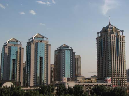
5 Accuracy Assessment Beijing resident (and research assoc.) performed an accuracy assessment based on 50 cm aerials Randomly distributed points verification Additional verification with Google Earth Overall average of the classification accuracy for the Beijing ASTER LULC scene 83% II Texture Analysis for Settlement Areas Objective: Extract building heights and urban canyons for the climate model one LC class & three different settlement categories [1] open space, e.g. water [2] small buildings, traditional, one story [3] medium size, years old, stories [4] tall buildings, recently build, > 20 stories Some impressions from Beijing Open space, water, class 1 Traditional buildings, class 2 Traditional buildings, class 2 5


6 Traditional buildings,, ASTER, class 2, 1250 m x 800 m Medium size buildings, class 3 Medium size buildings, class 3 Medium size buildings,, ASTER, class 3, 1000 m x 500 m Tall buildings, class 4 Tall buildings, class 4 6
 for each cell & Classification after GLCM values: [1] GLCM > 1 and 3 low texture, open space.")
![[2] GLCM > 3 and 12 = small buildings. [3] GLCM > 12 and 26 = medium texture, medium size buildings. [4] GLCM > 26 = high texture, tall, big buildings.](/docs-images/81/84054557/images/7-1.jpg "Tall buildings,, ASTER, class 4, 500 m x 500 m SPOT Texture Analysis Legend: open space, water small, traditional buildings medium size buildings tall buildings")
 Compare and rank those urban areas MANY THANKS FOR YOUR")
7 SPOT pan From the OASIS program SPOT pan 5 m spatial resolution OBIA, segments with a regular grid pattern 50 m cell size (10 x the original pixel extend) GLCM (Grey Level Co-occurrence occurrence Matrix) for each cell & Classification after GLCM values: [1] GLCM > 1 and 3 low texture, open space. [2] GLCM > 3 and 12 = small buildings. [3] GLCM > 12 and 26 = medium texture, medium size buildings. [4] GLCM > 26 = high texture, tall, big buildings. Tall buildings,, ASTER, class 4, 500 m x 500 m SPOT Texture Analysis Legend: open space, water small, traditional buildings medium size buildings tall buildings (missing here) Conclusions ASTER provides image data suitable for urban object mapping (medium scale) OBIA is essential for the classification Future research: Improve SPOT texture analysis Adopt OBIA to more natural environments on earth (frequent updates of urban areas) Compare and rank those urban areas MANY THANKS FOR YOUR ATTENTION matthias.moeller@uni-bamberg.de thomas.blaschke@sbg.ac.at 7
This is trial version
 Journal of Rangeland Science, 2012, Vol. 2, No. 2 J. Barkhordari and T. Vardanian/ 459 Contents available at ISC and SID Journal homepage: www.rangeland.ir Full Paper Article: Using Post-Classification
ia PU BLi s g C o M Pa K T Wa i n CD-1576
 M h M y CD-1576 o M Pa g C n ar ia PU BLi s in K T Wa i n ed National Geography Standards National Geography Standards Teachers leading discussions while completing units and activities is a prerequisite
FLOOD DAMAGE ASSESSMENT INTEGRATING GEOSPATIAL TECHNOLOGIES. A CASE STUDY IN HUE, VIET NAM
 Paper 5-4-2 FLOOD DAMAGE ASSESSMENT INTEGRATING GEOSPATIAL TECHNOLOGIES. A CASE STUDY IN HUE, VIET NAM DINH NGOC DAT, J. S. M. FOWZE, NGUYEN DUONG ANH, MANZUL K. HAZARIKA AND LAL SAMARAKOON GeoInformatics
UNIVERSITY OF CAMBRIDGE INTERNATIONAL EXAMINATIONS International General Certificate of Secondary Education
 UNIVERSITY OF CAMBRIDGE INTERNATIONAL EXAMINATIONS International General Certificate of Secondary Education *9231176876* GEOGRAPHY 0460/12 Paper 1 May/June 2013 Candidates answer on the Question Paper.
MAST ACADEMY OUTREACH. WOW (Weather on Wheels)
") MAST ACADEMY OUTREACH ELEMENTARY SCHOOL PROGRAM Adventures Aboard WOW (Weather on Wheels) On-Site Packet MAST Academy Maritime and Science Technology High School Miami-Dade County Public Schools Miami,
MAST ACADEMY OUTREACH ELEMENTARY SCHOOL PROGRAM Adventures Aboard WOW (Weather on Wheels) On-Site Packet MAST Academy Maritime and Science Technology High School Miami-Dade County Public Schools Miami,
WEATHER ON WHEELS Elementary School Program
 WEATHER ON WHEELS Elementary School Program MAST ACADEMY OUTREACH On-Site Packet Miami-Dade County Public Schools Miami, Florida MAST ACADEMY OUTREACH WEATHER ON WHEELS ELEMENTARY ON-SITE HIGHLIGHTS PACKET
Object-Oriented Oriented Method to Classify the Land Use and Land Cover in San Antonio using ecognition Object-Oriented Oriented Image Analysis
 Object-Oriented Oriented Method to Classify the Land Use and Land Cover in San Antonio using ecognition Object-Oriented Oriented Image Analysis Jayar S. Griffith ES6973 Remote Sensing Image Processing
Evaluation of land surface temperature (LST) patterns in the urban agglomeration of Krakow using different satellite data and GIS
 patterns in the urban agglomeration of Krakow using different satellite data and GIS") Evaluation of land surface temperature (LST) patterns in the urban agglomeration of Krakow using different satellite data and GIS Jakub P. Walawender 1,2 1 Satellite Remote Sensing Centre, Institute of
Evaluation of land surface temperature (LST) patterns in the urban agglomeration of Krakow using different satellite data and GIS Jakub P. Walawender 1,2 1 Satellite Remote Sensing Centre, Institute of
Prentice Hall. World Explorer: People, Places, Cultures Grade 7. Oklahoma Priority Academic Student Skills (PASS) for Grade 7 World Geography
 for Grade 7 World Geography") Prentice Hall World Explorer: People, Places, Cultures 2007 Grade 7 C O R R E L A T E D T O for Grade 7 1. Locate, gather, analyze, and apply information from primary and secondary sources. WORLD GEOGRAPHY
Prentice Hall World Explorer: People, Places, Cultures 2007 Grade 7 C O R R E L A T E D T O for Grade 7 1. Locate, gather, analyze, and apply information from primary and secondary sources. WORLD GEOGRAPHY
LECTURE #14: Extreme Heat & Desertification
 GEOL 0820 Ramsey Natural Disasters Spring, 2018 LECTURE #14: Extreme Heat & Desertification Date: 27 February 2018 (lecturer: Dr. Shawn Wright) I. Start of Part 2 of the Course weather-related disasters
Hurricanes. Where's the Really Bad Weather 1. What: Rotating wind/rain storm Winds from 75 to 200 mph As big as 600 miles wide
 Where's the Really Bad Weather 1 Hurricanes What: Rotating wind/rain storm Winds from 75 to 200 mph As big as 600 miles wide Where: Start over oceans, fizzle out over land Investigation 1 What is Weather?
CLIMATE. Global climatic factors
 CLIMATE Global climatic factors Weather and climate Weather: short term variation of the state of a region Weather and climate Weather: short term variation of the state of a region Climate: statistical
Land cover/land use mapping and cha Mongolian plateau using remote sens. Title. Author(s) Bagan, Hasi; Yamagata, Yoshiki. Citation Japan.
 Bagan, Hasi; Yamagata, Yoshiki. Citation Japan.") Title Land cover/land use mapping and cha Mongolian plateau using remote sens Author(s) Bagan, Hasi; Yamagata, Yoshiki International Symposium on "The Imp Citation Region Specific Systems". 6 Nove Japan.
Title Land cover/land use mapping and cha Mongolian plateau using remote sens Author(s) Bagan, Hasi; Yamagata, Yoshiki International Symposium on "The Imp Citation Region Specific Systems". 6 Nove Japan.
Urban Geography. Unit 7 - Settlement and Urbanization
 Urban Geography Unit 7 - Settlement and Urbanization Unit 7 is a logical extension of the population theme. In their analysis of the distribution of people on the earth s surface, students became aware
Preparation of LULC map from GE images for GIS based Urban Hydrological Modeling
 International Conference on Modeling Tools for Sustainable Water Resources Management Department of Civil Engineering, Indian Institute of Technology Hyderabad: 28-29 December 2014 Abstract Preparation
Anjana Dewanji, Anindita Chatterjee & Achyut Kumar Banerjee. Agricultural & Ecological Research Unit Indian Statistical Institute Kolkata, India
 Anjana Dewanji, Anindita Chatterjee & Achyut Kumar Banerjee Agricultural & Ecological Research Unit Indian Statistical Institute Kolkata, India World wide distribution Distribution in India Present scenario
Spatio-temporal dynamics of the urban fringe landscapes
 Spatio-temporal dynamics of the urban fringe landscapes Yulia Grinblat 1, 2 1 The Porter School of Environmental Studies, Tel Aviv University 2 Department of Geography and Human Environment, Tel Aviv University
Written Response Test
 12 th International Geography Olympiad Tver, Russia 11 17 August 2015 Written Response Test Question and Answer Booklet Do NOT open the Booklet before instructed to do so by a supervisor. Name:... Team:...
MAPPING LAND USE/ LAND COVER OF WEST GODAVARI DISTRICT USING NDVI TECHNIQUES AND GIS Anusha. B 1, Sridhar. P 2
 MAPPING LAND USE/ LAND COVER OF WEST GODAVARI DISTRICT USING NDVI TECHNIQUES AND GIS Anusha. B 1, Sridhar. P 2 1 M. Tech. Student, Department of Geoinformatics, SVECW, Bhimavaram, A.P, India 2 Assistant
Sensitivity Analysis of WRF Forecasts in Arizona During the Monsoon Season Case Study: August 2, 2005 to August 3, 2005
 Sensitivity Analysis of WRF Forecasts in Arizona During the Monsoon Season Case Study: August 2, 2005 to August 3, 2005 Christopher L. Castro and Stephen Bieda III University of Arizona Susanne Grossman-Clarke
Arizona Climate Summary May 2012
 Arizona Climate Summary May 2012 Summary of conditions for April 2012 April 2012 Temperature and Precipitation Summary April 1 st 16 th : Although April began with another low pressure system sweeping
Object Based Land Cover Extraction Using Open Source Software
 Object Based Land Cover Extraction Using Open Source Software Abhasha Joshi 1, Janak Raj Joshi 2, Nawaraj Shrestha 3, Saroj Sreshtha 4, Sudarshan Gautam 5 1 Instructor, Land Management Training Center,
MAST ACADEMY OUTREACH. WOW (Weather on Wheels)
") MAST ACADEMY OUTREACH ELEMENTARY PROGRAM Adventures Aboard WOW (Weather on Wheels) Teacher Instructions / Answer Keys MAST Academy Maritime and Science Technology High School Miami-Dade County Public Schools
MAST ACADEMY OUTREACH ELEMENTARY PROGRAM Adventures Aboard WOW (Weather on Wheels) Teacher Instructions / Answer Keys MAST Academy Maritime and Science Technology High School Miami-Dade County Public Schools
RR#5 - Free Response
 Base your answers to questions 1 through 3 on the data table below and on your knowledge of Earth Science. The table shows the area, in million square kilometers, of the Arctic Ocean covered by ice from
Detection of Sea Ice/ Melt Pond from Aerial Photos through Object-based Image Classification Scheme
 NEMC 213 August 5-9, San Antonio, TX Detection of Sea Ice/ Melt Pond from Aerial Photos through Object-based Image Classification Scheme Xin Miao 12, Hongjie Xie 2, Zhijun Li 3, Ruibo Lei 4 1 Department
DEPARTMENT OF GEOGRAPHY B.A. PROGRAMME COURSE DESCRIPTION
 DEPARTMENT OF GEOGRAPHY B.A. PROGRAMME COURSE DESCRIPTION (3 Cr. Hrs) (2340100) Geography of Jordan (University Requirement) This Course pursues the following objectives: - The study the physical geographical
Earth Observation & GeoSpatial Information for Monitoring Urban SDG Indicators. Global Urbanization Trend
 Earth Observation & GeoSpatial Information for Monitoring Urban SDG Indicators Yifang Ban, Professor Director, Division of Geoinformatics Vice Chair, Department for Urban Planning and Environment KTH Royal
URBAN HEAT ISLAND IN SEOUL
 URBAN HEAT ISLAND IN SEOUL Jong-Jin Baik *, Yeon-Hee Kim ** *Seoul National University; ** Meteorological Research Institute/KMA, Korea Abstract The spatial and temporal structure of the urban heat island
Chapter 3 Section 3 World Climate Regions In-Depth Resources: Unit 1
 Guided Reading A. Determining Cause and Effect Use the organizer below to show the two most important causes of climate. 1. 2. Climate B. Making Comparisons Use the chart below to compare the different
The Five Themes of Geography
 The Five Themes of Geography The Five Themes of Geography Main Idea: Geographers use the Five Themes of Geography to help them study the Earth. The Five Themes of Geography Geography and You: Suppose a
Alliance Created State Giant Traveling Map Lesson
 Title: Comparing Arizona s Temperatures Recommended Grades: 4 th 5 th Time Needed: 30 minutes Objectives: Students will: Compare and contrast the geographic features of Arizona by researching seasonal
MAST ACADEMY OUTREACH. WOW (Weather on Wheels)
") MAST ACADEMY OUTREACH MIDDLE SCHOOL PROGRAM Adventures Aboard WOW (Weather on Wheels) On-Site Highlights Packet MAST Academy Maritime and Science Technology High School Miami-Dade County Public Schools
MAST ACADEMY OUTREACH MIDDLE SCHOOL PROGRAM Adventures Aboard WOW (Weather on Wheels) On-Site Highlights Packet MAST Academy Maritime and Science Technology High School Miami-Dade County Public Schools
Cambridge International Examinations Cambridge International General Certificate of Secondary Education
 Cambridge International Examinations Cambridge International General Certificate of Secondary Education *1869999605* GEOGRAPHY 0460/11 Paper 1 October/November 2017 Candidates answer on the Question Paper.
An Automated Object-Oriented Satellite Image Classification Method Integrating the FAO Land Cover Classification System (LCCS).
.") An Automated Object-Oriented Satellite Image Classification Method Integrating the FAO Land Cover Classification System (LCCS). Ruvimbo Gamanya Sibanda Prof. Dr. Philippe De Maeyer Prof. Dr. Morgan De
An Automated Object-Oriented Satellite Image Classification Method Integrating the FAO Land Cover Classification System (LCCS). Ruvimbo Gamanya Sibanda Prof. Dr. Philippe De Maeyer Prof. Dr. Morgan De
Mario Flores, Graduate Student Department of Applied Mathematics, UTSA. EES 5053: Remote Sensing
 Mario Flores, Graduate Student Department of Applied Mathematics, UTSA Miguel Balderas, E.I.T., Graduate Student Department of Civil/Environmental Engineering, UTSA EES 5053: Remote Sensing REMOTE SENSING
Plant Distribution in a Sonoran Desert City CAP LTER Data Explorations
 in a Sonoran Desert City CAP LTER Data Explorations Author: Ecology Explorers Team, adapted from data analysis by J. Walker and the CAP LTER 200 point survey Time: 15-30 minutes Grade Level: 9-12 Background:
Case Study: Australia. LI: To understand urbanisation issues and management strategies in Australia
 Case Study: Australia LI: To understand urbanisation issues and management strategies in Australia Warm Up Match the place names to the map: Urbanisation In 1910, fewer than 40% of Australians lived in
Paper Two - Optional Themes for Standard and Higher Level
 Paper Two - Optional Themes for Standard and Higher Level Timing: Approximately 40 minutes for each question (each is worth 20 marks). Choice: Higher Level candidates must answer three questions and Standard
SUPPORTING INFORMATION. Ecological restoration and its effects on the
 SUPPORTING INFORMATION Ecological restoration and its effects on the regional climate: the case in the source region of the Yellow River, China Zhouyuan Li, Xuehua Liu,* Tianlin Niu, De Kejia, Qingping
Abstract: Introduction: 10 th ESRI India User Conference 2009 Geography in Action
 Mitigation of Thermal Pollution to enhance urban air quality through Remote Sensing and GIS Anshu Gupta, Lecturer, Centre of Remote Sensing and GIS, MANIT, Bhopal, E- mail: anshugupta20002001@gmail.com
MESOSCALE MODELLING OVER AREAS CONTAINING HEAT ISLANDS. Marke Hongisto Finnish Meteorological Institute, P.O.Box 503, Helsinki
 MESOSCALE MODELLING OVER AREAS CONTAINING HEAT ISLANDS Marke Hongisto Finnish Meteorological Institute, P.O.Box 503, 00101 Helsinki INTRODUCTION Urban heat islands have been suspected as being partially
About places and/or important events Landmarks Maps How the land is, hills or flat or mountain range Connected to maps World Different countries
 What do you think you know about geography? About places and/or important events Landmarks Maps How the land is, hills or flat or mountain range Connected to maps World Different countries What do you
Unit 1: Basics of Geography Test Review
 Name Date Period Unit 1: Basics of Geography Test Review Directions: Reading the following sections and complete the questions, charts, and diagrams. Types of Maps Maps that have a particular theme are
The Impact of Geography in South and East Asia
 The Impact of Geography in South and East Asia Gobi desert, Mongolia Essential Question: How does geography impact the distribution of population throughout South and East Asia? I CAN Explain how geography
Climates of Earth. Lesson Outline LESSON 1. A. What is climate? 1. is the long-term average weather conditions that occur in a particular region.
 Lesson Outline LESSON 1 A. What is climate? 1. is the long-term average weather conditions that occur in a particular region. 2. Climate depends on how average weather conditions throughout the year. B.
Name: Regents Earth Science. Weather and Climate - Review Questions
 Name: Regents Earth Science Weather and Climate - Review Questions Date: Thayer - 279 1. People sometimes release substances into the atmosphere to increase the probability of rain by A) raising the air
netw rks Guided Reading Activity Essential Question: How does geography influence the way people live? Earth's Physical Geography
 Guided Reading Activity Lesson 1 Earth and the Sun Essential Question: How does geography influence the way people live? Looking at Earth Directions: What are the layers that make up Earth? Use your textbook
Sharthi Laldaparsad Statistics South Africa, Policy Research & Analysis. Sub-regional workshop on integration of administrative data,
 Sub-regional workshop on integration of administrative data, big data and geospatial information for the compilation of SDG indicators and International Workshop on Global Fundamental Geospatial Data Themes
GCSE 4241/02 GEOGRAPHY (Specification B) HIGHER TIER UNIT 1
 HIGHER TIER UNIT 1") Surname Centre Number Candidate Number Other Names 0 GCSE 4241/02 GEOGRAPHY (Specification B) HIGHER TIER UNIT 1 P.M. TUESDAY, 13 May 2014 1 hour For s use Question Maximum Mark Mark Awarded 1. 30 SPaG
Surname Centre Number Candidate Number Other Names 0 GCSE 4241/02 GEOGRAPHY (Specification B) HIGHER TIER UNIT 1 P.M. TUESDAY, 13 May 2014 1 hour For s use Question Maximum Mark Mark Awarded 1. 30 SPaG
Landuse and Landcover change analysis in Selaiyur village, Tambaram taluk, Chennai
 Landuse and Landcover change analysis in Selaiyur village, Tambaram taluk, Chennai K. Ilayaraja Department of Civil Engineering BIST, Bharath University Selaiyur, Chennai 73 ABSTRACT The synoptic picture
Our climate system is based on the location of hot and cold air mass regions and the atmospheric circulation created by trade winds and westerlies.
 CLIMATE REGIONS Have you ever wondered why one area of the world is a desert, another a grassland, and another a rainforest? Or have you wondered why are there different types of forests and deserts with
Space. Earth. EARTH and EARTH and SPACE SPACE. Earth. William B. Rice
 Space Earth rth EARTH and EARTH and SPACE SPACE SCIENCE Earth is covered with mountains, canyons, and oceans. These landforms change over time. Mountains are made. Valleys may become deeper. Earth s landforms
Mount Everest and the Gobi Desert
 Mount Everest and the Gobi Desert 1 Mount Everest is part of the mountain chain known as the Himalaya. Adventurers from all over the world come to try to climb it. Mount Everest is the highest mountain
Map Skills and Geographic Tools
 Name: Period: Map Skills and Geographic Tools TEKS: 8.9C interpret topographic maps and satellite views to identify land and erosional features and predict how these features may be reshaped by weathering
Cities 2070: What is Truly Sustainable? Antony Wood CTBUH Chief Executive Officer Research Professor, Illinois Institute of Technology
 Cities 2070: What is Truly Sustainable? Antony Wood CTBUH Chief Executive Officer Research Professor, Illinois Institute of Technology What are the Biggest Threats to Tall Buildings? Earthquakes? Jiji,
Population And Settlement Part I
 Population And Settlement Part I 0011 0010 1010 1101 0001 0100 1011 4 12 Think of the earth as a living organism that is being attacked by billions of bacteria whose numbers double every forty years. Either
Global temperature trend biases and statistical homogenization methods
 Global temperature trend biases and statistical homogenization methods Victor Venema & Ralf Lindau @VariabilityBlog variable-variability.blogspot.com Outline talk Early warming (1850 to 1920, red rectangle)
KNOWLEDGE-BASED CLASSIFICATION OF LAND COVER FOR THE QUALITY ASSESSEMENT OF GIS DATABASE. Israel -
 KNOWLEDGE-BASED CLASSIFICATION OF LAND COVER FOR THE QUALITY ASSESSEMENT OF GIS DATABASE Ammatzia Peled a,*, Michael Gilichinsky b a University of Haifa, Department of Geography and Environmental Studies,
Iceland. 1. Warm up. A. Talk about the picture and read the essay. B. Discuss the questions about the essay.
 1. Warm up A. Talk about the picture and read the essay. Iceland My country, Iceland, is one of the most beautiful countries on Earth. It is an island country. It is located in Europe, in the North Atlantic
Satellites, Weather and Climate Module 1: Introduction to the Electromagnetic Spectrum
 Satellites, Weather and Climate Module 1: Introduction to the Electromagnetic Spectrum What is remote sensing? = science & art of obtaining information through data analysis, such that the device is not
- World-wide cities are growing at a rate of 2% annually (UN 1999). - (60,3%) will reside in urban areas in 2030.
. - (60,3%) will reside in urban areas in 2030.") THE EFFECTIVENESS OF NEW TECHNOLOGIES FOR URBAN LAND MANAGEMENT BAHAAEDDINE I. AL HADDAD Centro de Política de Suelo y Valoraciones Universidad Politécnica de Cataluña Barcelona, España www.upc.es/cpsv
THE EFFECTIVENESS OF NEW TECHNOLOGIES FOR URBAN LAND MANAGEMENT BAHAAEDDINE I. AL HADDAD Centro de Política de Suelo y Valoraciones Universidad Politécnica de Cataluña Barcelona, España www.upc.es/cpsv
Geography. Total marks 100. Section I Pages marks Attempt Questions 1 15 Allow about 25 minutes for this section
 2006 HIGHER SCHOOL CERTIFICATE EXAMINATION Geography Total marks 100 General Instructions Reading time 5 minutes Working time 3 hours Write using black or blue pen Board-approved calculators may be used
Classification trees for improving the accuracy of land use urban data from remotely sensed images
 Classification trees for improving the accuracy of land use urban data from remotely sensed images M.T. Shalaby & A.A. Darwish Informatics Institute of IT, School of Computer Science and IT, University
Application of Topology to Complex Object Identification. Eliseo CLEMENTINI University of L Aquila
 Application of Topology to Complex Object Identification Eliseo CLEMENTINI University of L Aquila Agenda Recognition of complex objects in ortophotos Some use cases Complex objects definition An ontology
The Impact of Geography in South and East Asia
 The Impact of Geography in South and East Asia Gobi desert, Mongolia Essential Question: How does the geography of SE Asia impact trade and the distribution of population throughout the region? (AKS #52a)
M.C.PALIWAL. Department of Civil Engineering NATIONAL INSTITUTE OF TECHNICAL TEACHERS TRAINING & RESEARCH, BHOPAL (M.P.), INDIA
, INDIA") INVESTIGATIONS ON THE ACCURACY ASPECTS IN THE LAND USE/LAND COVER MAPPING USING REMOTE SENSING SATELLITE IMAGERY By M.C.PALIWAL Department of Civil Engineering NATIONAL INSTITUTE OF TECHNICAL TEACHERS
INVESTIGATIONS ON THE ACCURACY ASPECTS IN THE LAND USE/LAND COVER MAPPING USING REMOTE SENSING SATELLITE IMAGERY By M.C.PALIWAL Department of Civil Engineering NATIONAL INSTITUTE OF TECHNICAL TEACHERS
Ancient China. Teachers Curriculum Institute Geography and the Early Settlement of China 1. AW_ISN_U04_01 Ancient China Second Proof TCI18 108
 G e o g r a p h y C h a l l e n g e Ancient China N W E S 0 250 500 miles 0 250 500 kilometers Albers Conic Equal-Area Projection AW_ISN_U04_01 Ancient China Second Proof TCI18 108 Teachers Curriculum
Latitude & Longitude. Worksheets & activities to teach latitude & longitude. Includes notes, activities, review & all answer keys. 11 pages!
 Latitude & Longitude Worksheets & activities to teach latitude & longitude. Includes notes, activities, review & all answer keys. 11 pages! Lines of Latitude & Longitude Name: Lines of latitude and longitude
PAUL RUDOLPH Oriental Masonic Gardens
 1 PAUL RUDOLPH Oriental Masonic Gardens Latitude _ 41.3 N Longitude _ 72.9 W Climate: transition between Cfa _ Humid Subtropical and Dfa_ Humid Continental climate 2 Paul Rudolph INTRODUCTION Fig. 1 -
The Impact of Geography in South and East Asia
 The Impact of Geography in South and East Asia Gobi desert, Mongolia Essential Question: How does the geography of SE Asia impact trade and the distribution of population throughout the region? (AKS #52a)
VISUALIZATION URBAN SPATIAL GROWTH OF DESERT CITIES FROM SATELLITE IMAGERY: A PRELIMINARY STUDY
 CO-439 VISUALIZATION URBAN SPATIAL GROWTH OF DESERT CITIES FROM SATELLITE IMAGERY: A PRELIMINARY STUDY YANG X. Florida State University, TALLAHASSEE, FLORIDA, UNITED STATES ABSTRACT Desert cities, particularly
C N E S, U M R I R I S A
 M O N I T O R I N G U R B A N A R E A S W I T H S E N T I N E L - 2. APPLICATION TO THE UPDATE OF THE COPERNICUS HIGH RESOLUTION LAYER IMPERVIOUSNESS DEGREE O c t o b e r 2 5 th 2016, Brussels A n t o
World geography 3200/3202 Unit 2 review
 World geography 3200/3202 Unit 2 review 1. Does this statement use the terms revolve & rotate correctly? "Saturn revolves on its axis while several moons rotate around it." 2. Does this statement use the
TOM NEWBY SCHOOL EXAMINATION. Name: Grade 6. Question 1: Climates of the world [5]
![TOM NEWBY SCHOOL EXAMINATION. Name: Grade 6. Question 1: Climates of the world [5]](/thumbs/95/126118858.jpg "TOM NEWBY SCHOOL EXAMINATION. Name: Grade 6. Question 1: Climates of the world [5]") 1 TOM NEWBY SCHOOL EXAMINATION Subject GEOGRAPHY Examiner MRS P SINGH Date 25 NOVEMBER 2016 Total marks 50 Session 1 Duration 1 HOUR Grade 6 Moderator MISS M ALBERTYN Special instructions/ Equipment 1.
1 TOM NEWBY SCHOOL EXAMINATION Subject GEOGRAPHY Examiner MRS P SINGH Date 25 NOVEMBER 2016 Total marks 50 Session 1 Duration 1 HOUR Grade 6 Moderator MISS M ALBERTYN Special instructions/ Equipment 1.
Climate Regions. Combining Climate Graphs and Köppen s Classification
 Lab 15 Climate Regions Combining knowledge of the global patterns behind the major climatic controls, this lab will teach students how to construct climate graphs and then allow them to explore patterns
Climate Change Adaptation
 Climate Change Adaptation Adriána Hudecz, Technical University of Denmark ROADEX Final Seminar Rovaniemi, 25 April 2012 Climate Change Adaptation Outline: 1. Background/global climate change 2. Climate
Describing Cause and Effect
 Introduction RI.3.3 Describe the relationship between a series of historical events, scientific ideas or concepts, or steps in technical procedures in a text, using language that pertains to... cause/effect.
Urban Mapping & Change Detection. Sebastian van der Linden Humboldt-Universität zu Berlin, Germany
 Urban Mapping & Change Detection Sebastian van der Linden Humboldt-Universität zu Berlin, Germany Introduction - The urban millennium Source: United Nations Introduction Text Source: Google Earth Introduction
Ancient China UNIT 4 GEOGRAPHY CHALLENGE. 1 Unit 4 Geography Challenge. Teachers Curriculum Institute
 UNIT 4 GEOGRAPHY CHALLENGE Ancient China N W E S 0 250 500 miles 0 250 500 kilometers Albers Conic Equal-Area Projection AW_ISN_U04_01 Ancient China Second Proof TCI18 108 1 Unit 4 Geography Challenge
UNIT4. Ancient China. Geography and the Early Settlement of China. Three Chinese Philosophies The First Emperor of China
 UNIT4 Ancient China Lesson 19 Lesson 20 Lesson 21 Lesson 22 Lesson 23 Lesson 24 Geography and the Early Settlement of China The Shang Dynasty Three Chinese Philosophies The First Emperor of China The Han
Urban Tree Canopy Assessment Purcellville, Virginia
 GLOBAL ECOSYSTEM CENTER www.systemecology.org Urban Tree Canopy Assessment Purcellville, Virginia Table of Contents 1. Project Background 2. Project Goal 3. Assessment Procedure 4. Economic Benefits 5.
School Name Team # International Academy East Meteorology Test Graphs, Pictures, and Diagrams Diagram #1
 School Name Team # International Academy East Meteorology Test Graphs, Pictures, and Diagrams Diagram #1 Use the map above, and the locations marked A-F, to answer the following questions. 1. The center
1 What Is Climate? TAKE A LOOK 2. Explain Why do areas near the equator tend to have high temperatures?
 CHAPTER 17 1 What Is Climate? SECTION Climate BEFORE YOU READ After you read this section, you should be able to answer these questions: What is climate? What factors affect climate? How do climates differ
URBAN SPRAWL AND SPATIO TEMPORAL ANALYSIS OF HISAR CITY IN HARYANA USING REMOTE SENSING & GIS TECNOLOGY
 URBAN SPRAWL AND SPATIO TEMPORAL ANALYSIS OF HISAR CITY IN HARYANA USING REMOTE SENSING & GIS TECNOLOGY Shashikant 1, Pallavi Singh 2, R. D. Doi 3, Ankur Sharma 4, Ravinder Kumar 5, Parveen Bhatti 6 Abstract
MAP STUDY: INTERPRETATION OF SURVEY MAPS
 MAP STUDY: INTERPRETATION OF SURVEY MAPS Types and Elements of Maps Maps are drawn to represent the Earth on a piece of paper. Maps are used widely to represent the Earth. Maps use signs and symbols in
AP Human Geography Summer Homework 2016 JW Mitchell High School Mrs. Daniel
 AP Human Geography Summer Homework 2016 JW Mitchell High School Mrs. Daniel hdaniel@pasco.k12.fl.us Welcome to A.P. Human Geography. I am excited that you decided to take this journey to learn more about
DETECTION AND ANALYSIS OF LAND-USE/LAND-COVER CHANGES IN NAY PYI TAW, MYANMAR USING SATELLITE REMOTE SENSING IMAGES
 DETECTION AND ANALYSIS OF LAND-USE/LAND-COVER CHANGES IN NAY PYI TAW, MYANMAR USING SATELLITE REMOTE SENSING IMAGES Kay Khaing Oo 1, Eiji Nawata 1, Kiyoshi Torii 2 and Ke-Sheng Cheng 3 1 Division of Environmental
Cambridge IGCSE Geography past paper questions
 Cambridge IGCSE Geography Past paper questions are reproduced by permission of University of Cambridge International Examinations. QUESTION 1: Cambridge IGCSE Geography 04/01 Q2 June 2005 (a) Study Fig.
South, Southeast, and East Asia. Physical Geography
 South, Southeast, and East Asia Physical Geography Mountains v Mountains are important in Asia because they influence: A. Population patterns B. Movement of people and goods C. Climate Mountains v The
Welcome. C o n n e c t i n g
 Welcome C o n n e c t i n g YOU D i s c i p l i n e s Why is This Meeting......So Important Now? OUR WORLD Is Increasingly Challenged The Evidence Is Clear We Need Better Understanding and More Collaboration
DAMAGE DETECTION OF THE 2008 SICHUAN, CHINA EARTHQUAKE FROM ALOS OPTICAL IMAGES
 DAMAGE DETECTION OF THE 2008 SICHUAN, CHINA EARTHQUAKE FROM ALOS OPTICAL IMAGES Wen Liu, Fumio Yamazaki Department of Urban Environment Systems, Graduate School of Engineering, Chiba University, 1-33,
EO Information Services. Assessing Vulnerability in the metropolitan area of Rio de Janeiro (Floods & Landslides) Project
 Project") EO Information Services in support of Assessing Vulnerability in the metropolitan area of Rio de Janeiro (Floods & Landslides) Project Ricardo Armas, Critical Software SA Haris Kontoes, ISARS NOA World
EO Information Services in support of Assessing Vulnerability in the metropolitan area of Rio de Janeiro (Floods & Landslides) Project Ricardo Armas, Critical Software SA Haris Kontoes, ISARS NOA World
Looking at Communities: Comparing Urban and Rural Neighborhoods
 Looking at Communities: Comparing Urban and Rural Neighborhoods OVERVIEW & OBJECTIVES Our urban areas have become so dominant that frequently the children we teach have no connection with and very few
Abstract: About the Author:
 REMOTE SENSING AND GIS IN LAND USE PLANNING Sathees kumar P 1, Nisha Radhakrishnan 2 1 1 Ph.D Research Scholar, Department of Civil Engineering, National Institute of Technology, Tiruchirappalli- 620015,
Analysis on Climate Change of Guangzhou in Nearly 65 Years
 , pp.111-117 http://dx.doi.org/10.14257/astl.2016.138.24 Analysis on Climate Change of Guangzhou in Nearly 65 Years Wenzheng Yu, Haitao Liu, Chunyong Yin, Jin Wang College of Environmental Science and
Social Studies. Chapter 2 Canada s Physical Landscape
 Social Studies Chapter 2 Canada s Physical Landscape Introduction Canada s geography its landforms and climate - has a great impact on Canadians sense of identity. Planet Earth The earth is divided into
Fundamentals of Photographic Interpretation
 Principals and Elements of Image Interpretation Fundamentals of Photographic Interpretation Observation and inference depend on interpreter s training, experience, bias, natural visual and analytical abilities.
Learning Objective: Use photographs to find out about a foreign country
 Learning Objective: Use photographs to find out about a foreign country National Curriculum links: Geography (PoS 1a, 2a, 2c, 2d, 3a) Maths (Ma2 Number 5a) PSHE (1b, 4c) Resources: Google Earth (download
Module 2, Investigation 4: Log 1 Our coasts
 Module 2, Investigation 4: Log 1 Our coasts The coast is where the ocean meets land. Coastlines are always changing their shape. They are being worn away in some places and built up in others. Coasts can
AssessmentofUrbanHeatIslandUHIusingRemoteSensingandGIS
 Global Journal of HUMANSOCIAL SCIENCE: B Geography, GeoSciences, Environmental Science & Disaster Management Volume 16 Issue 2 Version 1.0 Type: Double Blind Peer Reviewed International Research Journal