Opportunities provided by fine-scale meteorological sensor array
|
|
|
- Toby Lawson
- 5 years ago
- Views:
Transcription


1 Opportunities provided by fine-scale meteorological sensor array R.M. Randall, C.M Hocut, D.K. Knapp, B.T. MacCall, & J.A. Smith
2 MSA Program Overview Army Challenge Research gaps exist which challenge the predictability of weather in complex terrain and urban environments that are of importance to the Army for successful battlefield operations. To improve the accuracy of atmospheric boundary layer modeling, high-resolution spatial and temporal data is needed to refine process parameterizations (mesoscale) and for development of microscale models. Key Technical Challenges To overcome these challenges a mesonet is required that encompasses a large continuous domain of varying topography at high spatial and temporal resolution, with continuous operation throughout varying seasonal background meteorological conditions. Extremely challenging due to: cost (equipment / installation / operation / maintenance), logistics and data management. Community Context High Resolution: Multi-agency field campaigns (e.g. MATERHORN, Perdigão, etc.) short in duration (~1-2 months), focused on specific background meteorological conditions. Lower Resolution: Mesonets such as Iowa Environmental, Washington AgWeatherNet, New York State, Quantum Weather, and Oklahoma have 100+ stations temporal resolution (~ 5 min avg.) and spatial resolution (~ variable, 8 32 km) 2


")


3 MSA Program Introduction Research Methodology Use of laboratory experiments and field experiments to refine mesoscale process parameterizations for NCAR s Weather Research and Forecasting (WRF) model and develop microscale models such as ARL s Atmospheric Boundary Layer Environment (ABLE) model to attain the capability to more accurately model atmospheric processes in complex terrain and urban environments. ABLE WRF LAB MSA 3
 near WSMR, NM")


4 Meteorological Sensor Array (MSA) near WSMR, NM San Andres Mountains Microscale Facility UAS Runway Acoustic Array Phase II: JER 14 km 40 km 2510 m Phase III: WSMR 1190 m Sacramento Mountains Organ Mountains A transformative facility for atmospheric science research! 4


.")

5 USDA-ARS Jornada Experimental Range National Wind Erosion Research Network Coordinating multi-partner National Wind Erosion Research Network. Basic and applied research into wind erosion and dust emission processes. Data assimilation for national and global modeling. 80,000 ha research facility with dedicated long-term ecological and dust monitoring. Jornada collaboration with ARL supporting data and knowledge sharing. Horizontal sediment mass flux ( ). Estimate produced using MODIS albedo-driven dust emission scheme with GLDAS. 500 m, 3 hr estimates. Model calibrated using Network data. Jornada s National Wind Erosion Research Network Site 5

")


6 MSA JER Phase II: Jornada Experimental Range (JER) (USDA/NMSU) Acoustic Array UAS Runway 1 st tower installed 1 Dec

7 MSA 10m Tower Configuration 10 m Level 2 m Level 2 m Level:!, #$, %, &', ( 10 m Level:!, #$, % Soil moisture probes at 5 and 10 cm, rain gauge, pyranometer. 7


: Effect of turbulence")

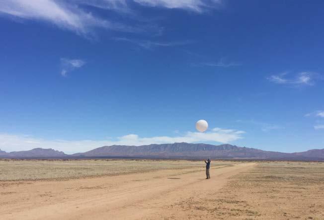
8 MSA UAS Instrumented UAS UND/ARL Flamingo UAS UAS Runway Sonic anemometer circuitry 4 channel Hot- Film CTA circuitry On-board data acquisition PC w/ SSD storage Cloud Cap Piccolo SL autopilot Boundary Layer Research: Test aerial platforms, Instrumentation, and sampling methods for process characterization ARL s Automated Impacts Routing (AIR): Effect of turbulence on efficiency - flight time, ability to maintain an automated flight path Aircraft thresholds 8


")
9 MSA Complex Terrain Phase III: JER / WSMR - San Andres Peak: 2510 m / 8235 ft Microscale Facility Y. Wang et al. (2018) Fernando et al. (2015) 9


 Heat Flux")

10 MSA Surface Energy Budget Measurements Net Radiometer Sonic Anemometer IRGAsonde + Sensible (!) & Latent (" # $) Heat Flux Soil Thermal Property Heat Flux Plate Water Content Reflectometer

!")
*%()*%++.%&'+ Dr.")


11 MSA Remote Sensing Doppler LiDAR: (Light Detection And Ranging)! " = $%&'()*%+ + -)*%()*%++.%&'+ Dr. Nikola Vasiljevic, Technical U. Denmark Multiple Synchronized LiDAR Scans directly measure /, 0, 1 Single LiDAR Scans Y. Wang et al

12 MSA Background Measurements!, #$, %, &, '( 12
 Field-scale mock urban cluster of buildings instrumented in")

 Development of DUE tactical decision aids")
 15: 275. doi:10.")
13 Future Phase: MSA Dense Urban Environments Phase IV: MSA Dense Urban Environments (DUE) Field-scale mock urban cluster of buildings instrumented in unprecedented detail to replicate the measurement capabilities of a laboratory wind tunnel to provide the basis for basic research on the dynamics of DUE boundary layers Objectives: Development, verification, and validation of microscale models (~10m grid) Development of DUE tactical decision aids including drone routing Improvement of mesoscale model DUE subgrid process parameterizations Zajic et al. Environ Fluid Mech (2015) 15: 275. doi: /s Dr. Yansen Wang (LBM-ABLE)
14 Conclusions Technical Significance Once complete, the MSA will be the premier meso/micro network for atmospheric science research due to unprecedented resolution (spacing less than 2 km and sampling of! = 20 hz) and a domain which includes diverse topography ranging from a valley at 1300 m to a mountain which peaks at 2500 m. Impact to Scientific Community The MSA will address a community need for high-resolution observational data for advancing the state of the science in development, verification and validation of fine-scale atmospheric prediction models, and provides a testing ground for atmospheric sensor development. Atmospheric modelers in the Air Force, Navy, NOAA, NCAR, DOE and academia will have access to a very unique multi-scale source of boundary layer atmospheric data for their research efforts targeting future improvements to operational weather forecasting capabilities. Impact to the DoD Will provide more accurate weather information and advanced decision aids to enhance/increase mission success rates. 14


15 Thank YOU! Questions? 15
Nowcasting and Urban Interactive Modeling Using Robotic and Remotely Sensed Data James Cogan, Robert Dumais, and Yansen Wang
 Nowcasting and Urban Interactive Modeling Using Robotic and Remotely Sensed Data James Cogan, Robert Dumais, and Yansen Wang Meteorological Modeling Branch Battlefield Environment Division Computational
University of Notre Dame 2. University of Utah 3. US Army Dugway Proving Grounds 4. University of Virginia 5. Oregon State University 6
 The Mountain Terrain Atmospheric Modeling and Observations (MATERHORN) Program: The First Field Experiment (MATERHORN-X1) H.J.S. Fernando 1, E. Pardyjak 2, D. Zajic 3, S. De Wekker 4 and J. Pace 3 S. Hoch
The Mountain Terrain Atmospheric Modeling and Observations (MATERHORN) Program: A Progress Report
 Program: A Progress Report") The Mountain Terrain Atmospheric Modeling and Observations (MATERHORN) Program: A Progress Report By H.J.S. Fernando, Univ. of Notre Dame, Notre Dame J. P. Hacker, Naval Postgraduate School/NCAR F. K.
The Mountain Terrain Atmospheric Modeling and Observations (MATERHORN) Program: A Progress Report By H.J.S. Fernando, Univ. of Notre Dame, Notre Dame J. P. Hacker, Naval Postgraduate School/NCAR F. K.
Wind and turbulence structure in the boundary layer around an isolated mountain: airborne measurements during the MATERHORN field study
 Wind and turbulence structure in the boundary layer around an isolated mountain: airborne measurements during the MATERHORN field study Stephan F.J. De Wekker 1, G.D. Emmitt 2, S. Greco 2, K. Godwin 2,
DACA 2013 Davos, Switzerland. University of Utah 2. University of Notre Dame 3. Universita Del Salento, Lecce, Italy 4
 First observations of the effects of shadow fronts on the surface layer dynamics during morning and evening transitions: MATERHORN-X Fall Eric Pardyjak 1, S. Hoch 1, D. Jensen 1, N. Gunawardena 1, S. Di
Near-surface weather prediction and surface data assimilation: challenges, development, and potential data needs
 Near-surface weather prediction and surface data assimilation: challenges, development, and potential data needs Zhaoxia Pu Department of Atmospheric Sciences University of Utah, Salt Lake City, Utah,
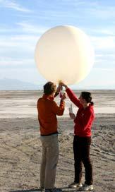
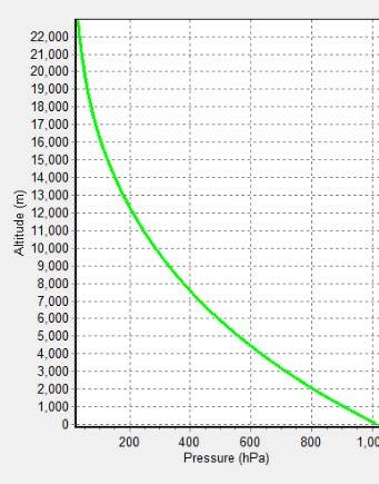
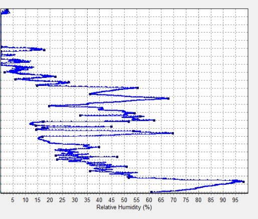
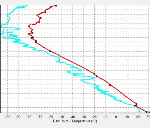
8.6 METEOROLOGICAL SENSOR ARRAY (MSA) OBSERVATIONS AND HIGH RESOLUTION MODEL VALIDATION
 OBSERVATIONS AND HIGH RESOLUTION MODEL VALIDATION") 8.6 METEOROLOGICAL SENSOR ARRAY (MSA) OBSERVATIONS AND HIGH RESOLUTION MODEL VALIDATION 1. BACKGROUND Gail Vaucher US Army Research Laboratory, White Sands Missile Range, NM Robert Edmonds Oak Ridge Associated
8.6 METEOROLOGICAL SENSOR ARRAY (MSA) OBSERVATIONS AND HIGH RESOLUTION MODEL VALIDATION 1. BACKGROUND Gail Vaucher US Army Research Laboratory, White Sands Missile Range, NM Robert Edmonds Oak Ridge Associated
Observations and modeling of the daytime boundary layer around an isolated Mountain
 Observations and modeling of the daytime boundary layer around an isolated Mountain Stephan De Wekker University of Virginia Sandip Pal (post-doc, February 2013) Mark Sghiatti (MS student, July 2013) Nevio
Regional methane emissions estimates in northern Pennsylvania gas fields using a mesoscale atmospheric inversion system
 Regional methane emissions estimates in northern Pennsylvania gas fields using a mesoscale atmospheric inversion system Thomas Lauvaux1, A. Deng1, B. Gaudet1, S. J. Richardson1, N. L. Miles1, J. N. Ciccarelli1,2,
Windcube TM Pulsed lidar wind profiler Overview of more than 2 years of field experience J.P.Cariou, R. Parmentier, M. Boquet, L.
 Windcube TM Pulsed lidar wind profiler Overview of more than 2 years of field experience J.P.Cariou, R. Parmentier, M. Boquet, L.Sauvage 15 th Coherent Laser Radar Conference Toulouse, France 25/06/2009
John R. Mecikalski #1, Martha C. Anderson*, Ryan D. Torn #, John M. Norman*, George R. Diak #
 P4.22 THE ATMOSPHERE-LAND EXCHANGE INVERSE (ALEXI) MODEL: REGIONAL- SCALE FLUX VALIDATIONS, CLIMATOLOGIES AND AVAILABLE SOIL WATER DERIVED FROM REMOTE SENSING INPUTS John R. Mecikalski #1, Martha C. Anderson*,
Summary of ABL group discussions: IHOP Planning meeting National Center for Atmospheric Research Boulder, CO April, 2001
 Summary of ABL group discussions: IHOP Planning meeting National Center for Atmospheric Research Boulder, CO 24-25 April, 2001 Scientific objectives: Summary list: It was agreed that the majority of the
MOUNTAIN TERRAIN ATMOSPHERIC MODELING AND OBSERVATIONS (MATERHORN) PROGRAM
 PROGRAM") MOUNTAIN TERRAIN ATMOSPHERIC MODELING AND OBSERVATIONS (MATERHORN) PROGRAM by H.J.S. Fernando Environmental Fluid Dynamics Laboratories Department of Civil Engineering & Geological Sciences and Aerospace
MOUNTAIN TERRAIN ATMOSPHERIC MODELING AND OBSERVATIONS (MATERHORN) PROGRAM by H.J.S. Fernando Environmental Fluid Dynamics Laboratories Department of Civil Engineering & Geological Sciences and Aerospace
1. Introduction/Goals and expected outcomes
 Request for use of the NSF Facilities for Education at the University of Colorado Boulder CABL: Characterizing the Atmospheric Boundary Layer Julie K. Lundquist Dept. of Atmospheric and Oceanic Sciences
Land Data Assimilation at NCEP NLDAS Project Overview, ECMWF HEPEX 2004
 Dag.Lohmann@noaa.gov, Land Data Assimilation at NCEP NLDAS Project Overview, ECMWF HEPEX 2004 Land Data Assimilation at NCEP: Strategic Lessons Learned from the North American Land Data Assimilation System
Investigation of the Air-Wave-Sea Interaction Modes Using an Airborne Doppler Wind Lidar: Analyses of the HRDL data taken during DYNAMO
 DISTRIBUTION STATEMENT A. Approved for public release; distribution is unlimited. Investigation of the Air-Wave-Sea Interaction Modes Using an Airborne Doppler Wind Lidar: Analyses of the HRDL data taken
Turbulence in the Stable Boundary Layer
 Turbulence in the Stable Boundary Layer Chemical-Biological Information Systems Austin, TX 11 January 2006 Walter D. Bach, Jr. and Dennis M. Garvey AMSRD-ARL-RO-EV & -CI-EE JSTO Project: AO06MSB00x Outline
RAL Advances in Land Surface Modeling Part I. Andrea Hahmann
 RAL Advances in Land Surface Modeling Part I Andrea Hahmann Outline The ATEC real-time high-resolution land data assimilation (HRLDAS) system - Fei Chen, Kevin Manning, and Yubao Liu (RAL) The fine-mesh
J7.3 INTERACTIVE MODELING AND SENSING IN URBAN SETTINGS. J. Cogan *, R. Dumais, Y. Wang, and M. Torres
 J7.3 INTERACTIVE MODELING AND SENSING IN URBAN SETTINGS J. Cogan *, R. Dumais, Y. Wang, and M. Torres Computational and Information Sciences Directorate Army Research Laboratory White Sands Missile Range,
Boundary Layer Science Challenges in the Context of Wind Energy
 Boundary Layer Science Challenges in the Context of Wind Energy WILLIAM J. SHAW 1 Pacific Northwest National Laboratory National Academies of Sciences, Engineering, and Medicine Workshop on the Future
Leveraging Existing and Future In-Situ Observational Networks
 Leveraging Existing and Future In-Situ Observational Networks John Horel* Department of Atmospheric Sciences University of Utah john.horel@utah.edu * COI Disclosure: equity stake in Synoptic Data Corp.
Outline. Research Achievements
 Taiwan Typhoon and Flood Research Institute, National Applied Research Laboratories 11F., No.97, Sec. 1, Roosevelt Rd., Zhongzheng Dist., Taipei City 10093, Taiwan (R.O.C.) http://www.ttfri.narl.org.tw/eng/index.html
Wind Assessment & Forecasting
 Wind Assessment & Forecasting GCEP Energy Workshop Stanford University April 26, 2004 Mark Ahlstrom CEO, WindLogics Inc. mark@windlogics.com WindLogics Background Founders from supercomputing industry
Mesoscale meteorological models. Claire L. Vincent, Caroline Draxl and Joakim R. Nielsen
 Mesoscale meteorological models Claire L. Vincent, Caroline Draxl and Joakim R. Nielsen Outline Mesoscale and synoptic scale meteorology Meteorological models Dynamics Parametrizations and interactions
Weather in the Connected Cockpit
 Weather in the Connected Cockpit What if the Cockpit is on the Ground? The Weather Story for UAS Friends and Partners of Aviation Weather November 2, 2016 Chris Brinton brinton@mosaicatm.com Outline Mosaic
SURF Progresses Contents
 SURF Progresses Contents 1 5th Workshop: June 21-23, 2017 2 SURF-2016 Summer Experiment 3 Preliminary results 4 Future plan (1) 5 th Workshop: June 21-23, 2017 SURF WS-5: Structure I. New Science Reports
WWRP RDP COPS Coordination Structure Science Questions Status Outlook
 WWRP RDP COPS Volker Wulfmeyer Institute of Physics and Meteorology University of Hohenheim Stuttgart, Germany, the COPS International Science Steering Committee, and the D-PHASE Steering Committee Coordination
Methodology for the creation of meteorological datasets for Local Air Quality modelling at airports
 Methodology for the creation of meteorological datasets for Local Air Quality modelling at airports Nicolas DUCHENE, James SMITH (ENVISA) Ian FULLER (EUROCONTROL Experimental Centre) About ENVISA Noise
SDG&E Meteorology. EDO Major Projects. Electric Distribution Operations
 Electric Distribution Operations SDG&E Meteorology EDO Major Projects 2013 San Diego Gas & Electric Company. All copyright and trademark rights reserved. OCTOBER 2007 WILDFIRES In 2007, wildfires burned
14.2 Weather impacts and routing services in support of airspace management operations. David I. Knapp, Jeffrey O. Johnson, David P.
 14.2 Weather impacts and routing services in support of airspace management operations David I. Knapp, Jeffrey O. Johnson, David P. Sauter U.S. Army Research Laboratory, Battlefield Environment Division,
The Terrain-Induced Rotor Experiment (T-REX)
") The Terrain-Induced Rotor Experiment (T-REX) J.D. Doyle 1 and V. Grubišić 2 1 Marine Meteorology Division 2 Desert Research Institute Introduction: The Terrain-induced Rotor Experiment (T-REX) is a coordinated
The Terrain-Induced Rotor Experiment (T-REX) J.D. Doyle 1 and V. Grubišić 2 1 Marine Meteorology Division 2 Desert Research Institute Introduction: The Terrain-induced Rotor Experiment (T-REX) is a coordinated
Validation of Boundary Layer Winds from WRF Mesoscale Forecasts over Denmark
 Downloaded from orbit.dtu.dk on: Dec 14, 2018 Validation of Boundary Layer Winds from WRF Mesoscale Forecasts over Denmark Hahmann, Andrea N.; Pena Diaz, Alfredo Published in: EWEC 2010 Proceedings online
The multiple uses of the Navy's Twin Otter Doppler Wind Lidar (TODWL) for atmospheric research
 for atmospheric research") The multiple uses of the Navy's Twin Otter Doppler Wind Lidar (TODWL) for atmospheric research G. D. Emmitt a, Steve Greco a, Chris O Handley a, Ralph Foster b, Dylan Reif c and Robert Bluth d a Simpson
The multiple uses of the Navy's Twin Otter Doppler Wind Lidar (TODWL) for atmospheric research G. D. Emmitt a, Steve Greco a, Chris O Handley a, Ralph Foster b, Dylan Reif c and Robert Bluth d a Simpson
Flux Tower Data Quality Analysis in the North American Monsoon Region
 Flux Tower Data Quality Analysis in the North American Monsoon Region 1. Motivation The area of focus in this study is mainly Arizona, due to data richness and availability. Monsoon rains in Arizona usually
PAM-Station Land-Owner Information Guide Project: CuPIDO, Tucson AZ, Jul/Aug 2006
 PAM-Station Land-Owner Information Guide Project: CuPIDO, Tucson AZ, Jul/Aug 2006 PropVane Anemometer mounted at 10-m Lightning Spike Two-Way radio antenna Sonic Anemometer Solar and Net Radiation sensors.
REVISION OF THE STATEMENT OF GUIDANCE FOR GLOBAL NUMERICAL WEATHER PREDICTION. (Submitted by Dr. J. Eyre)
") WORLD METEOROLOGICAL ORGANIZATION Distr.: RESTRICTED CBS/OPAG-IOS (ODRRGOS-5)/Doc.5, Add.5 (11.VI.2002) COMMISSION FOR BASIC SYSTEMS OPEN PROGRAMME AREA GROUP ON INTEGRATED OBSERVING SYSTEMS ITEM: 4 EXPERT
WORLD METEOROLOGICAL ORGANIZATION Distr.: RESTRICTED CBS/OPAG-IOS (ODRRGOS-5)/Doc.5, Add.5 (11.VI.2002) COMMISSION FOR BASIC SYSTEMS OPEN PROGRAMME AREA GROUP ON INTEGRATED OBSERVING SYSTEMS ITEM: 4 EXPERT
Eliezer Kit School of Mechanical Engineering, Tel-Aviv University. In collaboration with: Joe Fernando Chris Hocut Dan Liberzon
 Eliezer Kit School of Mechanical Engineering, Tel-Aviv University In collaboration with: Joe Fernando Chris Hocut Dan Liberzon Motivation and Layout of the talk Fine resolution measurements of atmospheric
Research on Fog and Low Clouds at Météo-France / CNRM
 Research on Fog and Low Clouds at Météo-France / CNRM 1) Improved site-specific numerical prediction COBEL-ISBA 1D numerical model CdG field experiment Operational forecast at Paris CdG international airport
Development of Innovative Technology to Provide Low-Cost Surface Atmospheric Observations in Data-sparse Regions
 Development of Innovative Technology to Provide Low-Cost Surface Atmospheric Observations in Data-sparse Regions Paul Kucera and Martin Steinson University Corporation for Atmospheric Research/COMET 3D-Printed
2.1 OBSERVATIONS AND THE PARAMETERISATION OF AIR-SEA FLUXES DURING DIAMET
 2.1 OBSERVATIONS AND THE PARAMETERISATION OF AIR-SEA FLUXES DURING DIAMET Peter A. Cook * and Ian A. Renfrew School of Environmental Sciences, University of East Anglia, Norwich, UK 1. INTRODUCTION 1.1
Working Group Initiation of Convection
 Working Group Initiation of Convection Ulrich Corsmeier Institut für Meteorologie und Klimaforschung (IMK) Forschungszentrum Karlsruhe/Universität Karlsruhe 2 nd COPS Workshop June 27 June 28, 2005 University
China-U.S. Collaboration on Rapid Urbanization. Jonathan Fink Vice President for Research and Economic Affairs Arizona State University August, 2004
 China-U.S. Collaboration on Rapid Urbanization Jonathan Fink Vice President for Research and Economic Affairs Arizona State University August, 2004 Why have an urban system science research agenda? More
DOPPLER LIDAR IN THE WIND FORECAST IMPROVEMENT PROJECTS
 EPJ Web of Conferences 11911, 10001 (2016) DOPPLER LIDAR IN THE WIND FORECAST IMPROVEMENT PROJECTS Yelena Pichugina 1, 2*, Robert Banta 2, Alan Brewer 2, Aditya Choukulkar 1, 2, Melinda Marquis 2, Joe
Addressing Diurnal Temperature Biases in the WRF Model
 Addressing Diurnal Temperature Biases in the WRF Model Jeffrey Massey University of Utah Collaborators: Jim Steenburgh, Jason Knievel, Sebastian Hoch, Josh Hacker Long term 2-m temperature verification
Wind Resource Analysis
 Wind Resource Analysis An Introductory Overview MGA/NWCC Midwestern Wind Energy: Moving It to Markets July 30, 2008 Detroit, Michigan Mark Ahlstrom 1 WindLogics Background Founded 1989 - supercomputing
Large-Eddy Simulations of Tropical Convective Systems, the Boundary Layer, and Upper Ocean Coupling
 DISTRIBUTION STATEMENT A. Approved for public release; distribution is unlimited. Large-Eddy Simulations of Tropical Convective Systems, the Boundary Layer, and Upper Ocean Coupling Eric D. Skyllingstad
SMAP and SMOS Integrated Soil Moisture Validation. T. J. Jackson USDA ARS
 SMAP and SMOS Integrated Soil Moisture Validation T. J. Jackson USDA ARS Perspective Linkage of SMOS and SMAP soil moisture calibration and validation will have short and long term benefits for both missions.
Complex Terrain (EDUCT) experiment, conducted by the National Center for Atmospheric
 experiment, conducted by the National Center for Atmospheric") Alex Ameen Shenandoah Trip Paper I visited Shenandoah National Park on April 11, 2009 to investigate the Education in Complex Terrain (EDUCT) experiment, conducted by the National Center for Atmospheric
Alex Ameen Shenandoah Trip Paper I visited Shenandoah National Park on April 11, 2009 to investigate the Education in Complex Terrain (EDUCT) experiment, conducted by the National Center for Atmospheric
Polar Weather Prediction
 Polar Weather Prediction David H. Bromwich Session V YOPP Modelling Component Tuesday 14 July 2015 A special thanks to the following contributors: Kevin W. Manning, Jordan G. Powers, Keith M. Hines, Dan
UFO Database. UFO Dissemination Workshop 23/04/2015. NLR, Amsterdam. Oleg A. Krasnov and the UFO team
 UFO Database UFO Dissemination Workshop 23/0/2015 NLR, Amsterdam Oleg A. Krasnov (o.a.krasnov@tudelft.nl) and the UFO team 2 / Outline UFO Database in Internet Database content Data collections UFO Toulouse
ATMOSPHERIC SCIENCE-ATS (ATS)
") Atmospheric Science-ATS (ATS) 1 ATMOSPHERIC SCIENCE-ATS (ATS) Courses ATS 150 Science of Global Climate Change Credits: 3 (3-0-0) Physical basis of climate change. Energy budget of the earth, the greenhouse
Atmospheric Science-ATS (ATS) 1 ATMOSPHERIC SCIENCE-ATS (ATS) Courses ATS 150 Science of Global Climate Change Credits: 3 (3-0-0) Physical basis of climate change. Energy budget of the earth, the greenhouse
Combining Deterministic and Probabilistic Methods to Produce Gridded Climatologies
 Combining Deterministic and Probabilistic Methods to Produce Gridded Climatologies Michael Squires Alan McNab National Climatic Data Center (NCDC - NOAA) Asheville, NC Abstract There are nearly 8,000 sites
Real-time PBL analysis system using profilers observations from The New York State Mesonet
 Real-time PBL analysis system using profilers observations from The New York State Mesonet Sarah Lu University at Albany State University of New York Outline Background System description and progress
Rapid Prototyping of Cutting-Edge Meteorological Technology: The ATEC 4DWX System
 Rapid Prototyping of Cutting-Edge Meteorological Technology: The ATEC 4DWX System James F. Bowers U.S. Army Dugway Proving Ground Dugway, Utah 84022-5000 Scott P. Swerdlin and Thomas T. Warner National
AgWeatherNet A Tool for Making Decisions Based on Weather
 AgWeatherNet A Tool for Making Decisions Based on Weather Gerrit Hoogenboom Director, AgWeatherNet & Professor of Agrometeorology Washington State University Prosser, Washington November 14, 2013 Washington
APPENDIX 2 OVERVIEW OF THE GLOBAL PRECIPITATION MEASUREMENT (GPM) AND THE TROPICAL RAINFALL MEASURING MISSION (TRMM) 2-1
 AND THE TROPICAL RAINFALL MEASURING MISSION (TRMM) 2-1") APPENDIX 2 OVERVIEW OF THE GLOBAL PRECIPITATION MEASUREMENT (GPM) AND THE TROPICAL RAINFALL MEASURING MISSION (TRMM) 2-1 1. Introduction Precipitation is one of most important environmental parameters.
APPENDIX 2 OVERVIEW OF THE GLOBAL PRECIPITATION MEASUREMENT (GPM) AND THE TROPICAL RAINFALL MEASURING MISSION (TRMM) 2-1 1. Introduction Precipitation is one of most important environmental parameters.
UNIVERSITY OF CALIFORNIA
 UNIVERSITY OF CALIFORNIA Methods of Improving Methane Emission Estimates in California Using Mesoscale and Particle Dispersion Modeling Alex Turner GCEP SURE Fellow Marc L. Fischer Lawrence Berkeley National
A Community Gridded Atmospheric Forecast System for Calibrated Solar Irradiance
 A Community Gridded Atmospheric Forecast System for Calibrated Solar Irradiance David John Gagne 1,2 Sue E. Haupt 1,3 Seth Linden 1 Gerry Wiener 1 1. NCAR RAL 2. University of Oklahoma 3. Penn State University
The Kentucky Mesonet: Entering a New Phase
 The Kentucky Mesonet: Entering a New Phase Stuart A. Foster State Climatologist Kentucky Climate Center Western Kentucky University KCJEA Winter Conference Lexington, Kentucky February 9, 2017 Kentucky
Status-quo of COPS Scientific Preparation, Candidate Instrumentation, Workshop Overview
 Status-quo of COPS Scientific Preparation, Candidate Instrumentation, Workshop Overview Andreas Behrendt, Volker Wulfmeyer Institut für Physik und Meteorologie (IPM), Universität Hohenheim, Stuttgart Christoph
The WRF Developmental Testbed Center (DTC)
") The WRF Developmental Testbed Center (DTC) Bob Gall A facility where the NWP research and operational communities interact to accelerate testing and evaluation of new models and techniques for research
The WRF Developmental Testbed Center (DTC) Bob Gall A facility where the NWP research and operational communities interact to accelerate testing and evaluation of new models and techniques for research
NOAA Research and Development Supporting NextGen. Darien Davis NOAA Office of Oceanic and Atmospheric Research June 22, 2009
 NOAA Research and Development Supporting NextGen Darien Davis Darien.l.davis@noaa.gov NOAA Office of Oceanic and Atmospheric Research June 22, 2009 FAA/NOAA Coordination Developing an integrated science
The National Operational Hydrologic Remote Sensing Center Operational Snow Analysis
 The National Operational Hydrologic Remote Sensing Center Operational Snow Analysis World Meteorological Organization Global Cryosphere Watch Snow-Watch Workshop Session 3: Snow Analysis Products Andrew
DEVELOPMENT OF A FORECAST EARLY WARNING SYSTEM ethekwini Municipality, Durban, RSA. Clint Chrystal, Natasha Ramdass, Mlondi Hlongwae
 DEVELOPMENT OF A FORECAST EARLY WARNING SYSTEM ethekwini Municipality, Durban, RSA Clint Chrystal, Natasha Ramdass, Mlondi Hlongwae LOCATION DETAILS AND BOUNDARIES ethekwini Municipal Area = 2297 km 2
The New York City Urban Atmospheric Observatory An Overview
 The New York City Urban Atmospheric Observatory An Overview 84th Annual Meeting of the American Meteorological Society, Special Session on Urban Meteorology 11 Jan 2004 R. Michael Reynolds Brookhaven National
Remote Sensing and Sensor Networks:
 SDG&E Meteorology Remote Sensing and Sensor Networks: Providing meteorological intelligence to support system operations Mike Espinoza Project Manager Steven Vanderburg Senior Meteorologist Brian D Agostino
A Facility for Producing Consistent Remotely Sensed Biophysical Data Products of Australia
 TERRESTRIAL ECOSYSTEM RESEARCH NETWORK - AusCover - A Facility for Producing Consistent Remotely Sensed Biophysical Data Products of Australia June, 2011 Mervyn Lynch Professor of Remote Sensing Curtin
ARM Climate Research Facility: Goals and Objectives
 ARM Climate Research Facility: Goals and Objectives Provide the national and international scientific community with the infrastructure needed for scientific research on global change Global change research
MODELING AND MEASUREMENTS OF THE ABL IN SOFIA, BULGARIA
 MODELING AND MEASUREMENTS OF THE ABL IN SOFIA, BULGARIA P58 Ekaterina Batchvarova*, **, Enrico Pisoni***, Giovanna Finzi***, Sven-Erik Gryning** *National Institute of Meteorology and Hydrology, Sofia,
Ship-Based UAV Measurements of Air-Sea Interaction in Marine Atmospheric Boundary Layer Processes in the Equatorial Indian Ocean
 DISTRIBUTION STATEMENT A. Approved for public release; distribution is unlimited. Ship-Based UAV Measurements of Air-Sea Interaction in Marine Atmospheric Boundary Layer Processes in the Equatorial Indian
Taiwan s South China Sea-Maritime Continent (SCS-MC) Field Campaign ( )
 Field Campaign ( )") Taiwan s South China Sea-Maritime Continent (SCS-MC) Field Campaign (2017-2019) Lead scientists: Po-Hsiung Lin (NTU), Yu-Chieng Liou (NCU/TTFRI) The Maritime Continent (MC) and South China Sea (SCS) acts
Taiwan s South China Sea-Maritime Continent (SCS-MC) Field Campaign (2017-2019) Lead scientists: Po-Hsiung Lin (NTU), Yu-Chieng Liou (NCU/TTFRI) The Maritime Continent (MC) and South China Sea (SCS) acts
THE INFLUENCE OF HIGHLY RESOLVED SEA SURFACE TEMPERATURES ON METEOROLOGICAL SIMULATIONS OFF THE SOUTHEAST US COAST
 THE INFLUENCE OF HIGHLY RESOLVED SEA SURFACE TEMPERATURES ON METEOROLOGICAL SIMULATIONS OFF THE SOUTHEAST US COAST Peter Childs, Sethu Raman, and Ryan Boyles State Climate Office of North Carolina and
Forecasting of Optical Turbulence in Support of Realtime Optical Imaging and Communication Systems
 Forecasting of Optical Turbulence in Support of Realtime Optical Imaging and Communication Systems Randall J. Alliss and Billy Felton Northrop Grumman Corporation, 15010 Conference Center Drive, Chantilly,
Steven Greco* and George D. Emmitt Simpson Weather Associates, Charlottesville, VA. 2. Experiments
 3.3 INVESTIGATION OF FLOWS WITHIN COMPLEX TERRAIN AND ALONG COASTLINES USING AN AIRBORNE DOPPLER WIND LIDAR: OBSERVATIONS AND MODEL COMPARISONS Steven Greco* and George D. Emmitt Simpson Weather Associates,
Ocean-Atmosphere Fluxes & Marine Meteorology
 Ocean-Atmosphere Fluxes & Marine Meteorology Breakout Group Questions How can the CND be enhanced to better address this science theme? What other approaches could be combined with the observatory elements
F O U N D A T I O N A L C O U R S E
 F O U N D A T I O N A L C O U R S E December 6, 2018 Satellite Foundational Course for JPSS (SatFC-J) F O U N D A T I O N A L C O U R S E Introduction to Microwave Remote Sensing (with a focus on passive
The Deep Propagating Gravity Wave Experiment (DEEPWAVE) Science Overview and Approach
 Science Overview and Approach") The Deep Propagating Gravity Wave Experiment (DEEPWAVE) Science Overview and Approach U.S. PIs: Dave Fritts 1, Ron Smith 2, Mike Taylor 3, Jim Doyle 4, Steve Eckermann 5, and Steve Smith 6 1 GATS, Boulder,
The Deep Propagating Gravity Wave Experiment (DEEPWAVE) Science Overview and Approach U.S. PIs: Dave Fritts 1, Ron Smith 2, Mike Taylor 3, Jim Doyle 4, Steve Eckermann 5, and Steve Smith 6 1 GATS, Boulder,
Weather Considerations for UAS Integration
 Weather Considerations for UAS Integration Scot Campbell 8 December 2016 Sponsor: Steve Abelman, ANG-C6 DISTRIBUTION STATEMENT A. Approved for public release: distribution unlimited. Legal Notices This
Operational Perspectives on Hydrologic Model Data Assimilation
 Operational Perspectives on Hydrologic Model Data Assimilation Rob Hartman Hydrologist in Charge NOAA / National Weather Service California-Nevada River Forecast Center Sacramento, CA USA Outline Operational
WWRP Implementation Plan Reporting AvRDP
 WWRP Implementation Plan Reporting AvRDP Please send you report to Paolo Ruti (pruti@wmo.int) and Sarah Jones (sarah.jones@dwd.de). High Impact Weather and its socio economic effects in the context of
Remote sensing data assimilation in WRF-UCM mesoscale model: Madrid case study
 Air Pollution XVIII 15 Remote sensing data assimilation in WRF-UCM mesoscale model: case study R. San José 1, J. L. Pérez 1, J. L. Morant 1 & R. M. González 2 1 Environmental Software and Modelling Group,
Performance of Radar Wind Profilers, Radiosondes, and Surface Flux Stations at the Southern Great Plains (SGP) Cloud and Radiation Testbed (CART) Site
 Cloud and Radiation Testbed (CART) Site") Performance of Radar Wind Profilers, Radiosondes, and Surface Flux Stations at the Southern Great Plains (SGP) Cloud and Radiation Testbed (CART) Site R. L. Coulter, B. M. Lesht, M. L. Wesely, D. R. Cook,
Performance of Radar Wind Profilers, Radiosondes, and Surface Flux Stations at the Southern Great Plains (SGP) Cloud and Radiation Testbed (CART) Site R. L. Coulter, B. M. Lesht, M. L. Wesely, D. R. Cook,
RPAS based observation on the Arctic Boundary Layer during the ISOBAR campaigns on Andøya and Hailuoto
 U N I V E R S I T Y O F B E R G E N RPAS based observation on the Arctic Boundary Layer during the ISOBAR campaigns on Andøya and Hailuoto S Kral 1, J Reuder 1, L Båserud 1, G Urbancic 1,M Jonassen 2;1,
UNCLASSIFIED R-1 ITEM NOMENCLATURE FY 2013 OCO
 Exhibit R-2, RDT&E Budget Item Justification: PB 213 Army DATE: February 212 COST ($ in Millions) FY 211 FY 212 Base OCO Total FY 214 FY 215 FY 216 FY 217 Cost To Complete Total Cost Total Program Element
The NASA Short-term Prediction Research and Transition (SPoRT) Center:
 Center:") The NASA Short-term Prediction Research and Transition (SPoRT) Center: Opportunities for Collaboration in the Great Lakes Region Andrew Molthan NASA Marshall Space Flight Center, Huntsville, AL andrew.molthan@nasa.gov
The NASA Short-term Prediction Research and Transition (SPoRT) Center: Opportunities for Collaboration in the Great Lakes Region Andrew Molthan NASA Marshall Space Flight Center, Huntsville, AL andrew.molthan@nasa.gov
SCIENTIFIC REPORT. Host: Sven-Erik Gryning (DTU Wind Energy, Denmark) Applicant: Lucie Rottner (Météo-France, CNRM, France)
 Applicant: Lucie Rottner (Météo-France, CNRM, France)") SCIENTIFIC REPORT ACTION: ES1303 TOPROF STSM: COST-STSM-ES1303-30536 TOPIC: Validation of real time turbulence estimation and measurement of wind gust using Doppler lidar. VENUE: Technical University of
SCIENTIFIC REPORT ACTION: ES1303 TOPROF STSM: COST-STSM-ES1303-30536 TOPIC: Validation of real time turbulence estimation and measurement of wind gust using Doppler lidar. VENUE: Technical University of
Emerging Needs, Challenges and Response Strategy
 Emerging Needs, Challenges and Response Strategy Development of Integrated Observing Systems in China JIAO Meiyan Deputy Administrator China Meteorological Administration September 2011 Geneva Outline
MID-TERM CONFERENCE CREST
 MID-TERM CONFERENCE CREST 23 November 2017 Innovation in Coastal Monitoring Alain De Wulf (Ugent, Geography Dept.) Innovation in coastal monitoring Outline Why? How? What (tools do we use to assess)? Conclusion
Improved Atmospheric Stable Boundary Layer Formulations for Navy Seasonal Forecasting
 DISTRIBUTION STATEMENT A. Approved for public release; distribution is unlimited. Improved Atmospheric Stable Boundary Layer Formulations for Navy Seasonal Forecasting Michael Tjernström Department of
and soils characterizing would be defined.
 Working out of the basic network for monitoring of natural and climatic processes in Siberia M.V. Kabanov, V.V. Zuev, V.А. Krutikov Institute of Monitoring of Climatic and Ecological Systems SB RAS, Tomsk,
Environmental Fluid Dynamics
 Environmental Fluid Dynamics ME EN 7710 Spring 2015 Instructor: E.R. Pardyjak University of Utah Department of Mechanical Engineering Definitions Environmental Fluid Mechanics principles that govern transport,
A NUMERICAL MODEL-BASED METHOD FOR ESTIMATING WIND SPEED REGIME IN OUTDOOR AND SEMI-OUTDOOR SITES IN THE URBAN ENVIRONMENT
 Proceedings of the 13 th International Conference on Environmental Science and Technology Athens, Greece, 5-7 September 2013 A NUMERICAL MODEL-BASED METHOD FOR ESTIMATING WIND SPEED REGIME IN OUTDOOR AND
Eddy Covariance. Method. The
 The Eddy Covariance Method Used for a variety of applications, including: Ecosystem Gas Exchange, Climate Change Research, Evapotranspiration, Agricultural Research, Carbon Sequestration, Landfill Emissions,
GCOM-W1 now on the A-Train
 GCOM-W1 now on the A-Train GCOM-W1 Global Change Observation Mission-Water Taikan Oki, K. Imaoka, and M. Kachi JAXA/EORC (& IIS/The University of Tokyo) Mini-Workshop on A-Train Science, March 8 th, 2013
Dust prediction models
 Dust prediction models Sara Basart 1 (sara.basart@bsc.es), E. Terradellas 2, E. Cuevas 3, O. Jorba 1, J.M. Baldasano 1 and F. Benincasa 1 1 Earth Sciences Department, BSC, Barcelona, Spain 2 AEMET, Barcelona,
Thermodynamic Profiling Technology Workshop
 Thermodynamic Profiling Technology Workshop Characteristics of a Testbed: NOAA/NWS Testbed Implementation David Helms Office of Science and Technology NOAA National Weather Service Boulder, Colorado April
Assessment of wind energy for Nevada using towers and mesoscale modeling
 Assessment of wind energy for Nevada using towers and mesoscale modeling Darko Koracin, Richard L. Reinhardt, Marshall B. Liddle, Travis McCord, Domagoj Podnar, and Timothy B. Minor Desert Research Institute,
Idaho Power Company s Cloud Seeding Program May 6, 2016
 Idaho Power Company s Cloud Seeding Program May 6, 2016 Shaun Parkinson, PhD, P.E. Overview What is cloud seeding & how is it done Idaho Power s history with cloud seeding Idaho Power s cloud seeding projects
MPAS Atmospheric Boundary Layer Simulation under Selected Stability Conditions: Evaluation using the SWIFT dataset
 MPAS Atmospheric Boundary Layer Simulation under Selected Stability Conditions: Evaluation using the SWIFT dataset Rao Kotamarthi, Yan Feng, and Jiali Wang Argonne National Laboratory & MMC Team Motivation:
MOSAiC Science Implementation The Multidisciplinary drifting Observatory for the Study of Arctic Climate
 MOSAiC Science Implementation The Multidisciplinary drifting Observatory for the Study of Arctic Climate MOSAiC Coordination Team M. Shupe. 13 March 2016 MOSAiC Plan Drifting, interdisciplinary process