4/18/2006 Olga N. Krankina, OSU
|
|
|
- Lester Copeland
- 5 years ago
- Views:
Transcription
1
2 (Northern Eurasia Landcover Dynamics Analysis) Monitoring and validating the distribution and change in land cover across Northern Eurasia
3 Objectives Characterize land cover and its change across boreal and temperate Northern Eurasia Develop methods, data, and collaborations needed to monitor future changes The Team US Oregon State University - Olga N. Krankina NASA Goddard Space Flight Center Jeff Masek and Jeff Morisette Boston University - Mark Friedl and Curtis Woodcock University of Maryland - Ivan Csiszar, Guoqing Sun, and Tatiana Loboda USDA FS Pacific Northwest Research Station Warren Cohen Eurasia Space Research Institute, Russian Academy of Sciences, Moscow Eugeny Lupian, Sergey Bartalev, Dmitry Ershov Center for Information Technologies Development, Moscow Alexander Maslov and Natalia Vandysheva Institute of Monitoring of Climatic and Ecological Systems, Tomsk Evgeny Gordov V.N. Sukachev Institute of Forest, Krasnoyarsk Slava Kharuk Institute of Biology, Komi Scientific Center, Syktyvkar Vladimir Elsakov Institute of Sustainable Development of Ukraine, Kiev Mykola Zalogin

4
5 Approach Combine remote sensing data (Landsat, MODIS) and local knowledge of land-cover conditions and change to validate and improve land cover / land-cover change products for Northern Eurasia establish a set of test sites for land cover / change analysis use these sites to validate global and regional land cover / change products develop methods for continental mapping of vegetation disturbance produce a new, updated land cover map for Northern Eurasia based on MODIS data
6 Motivation Improved land cover maps with known accuracies are critical for: successful management of natural resources implementation of international conventions a large array of development and aid programs advances in global change research Carbon cycling different types of land cover differ vastly in C exchange with the atmosphere for the same values of LAI or NPP Is a forest a source or a sink of C? Depends on when and how it was disturbed last time.
7 Motivation (continued) Why focus on Northern Eurasia? the sheer size of the Northern Eurasia region validation sites are sparse several land-cover types are unique the role of disturbance is of tremendous importance Multitude of land-cover products is available with large disagreement among them
8 Location of NELDA test sites (Map was created at EC JRC as part of GLC 2000 project, Bartalev et al. 2003) 4/18/2006 Olga N. Krankina, OSU


9 MODIS 2001 Land Cover Map
10 Agreement among land cover products # of different classes Describes number of different classes for each pixel in GLC2000, MODIS, IGBP-DIS, UMD based on a generalized legend (Image credit: M. Herold & C. Schmullius, GOFC-GOLD Land Cover Implementation Team Project Office)

11

12 1990 Forest Cover Map of USSR

13 Areas undergoing high rates of land cover change between 1980 and 2000 (Millenium Ecosystem Assessment, 2005).
14 Motivation (continued) Contribute to GOFC-GOLD NERIN (Northern Eurasia Regional Information Network) NEESPI Opportunity: Data and methods are available Past research by team members and broader community

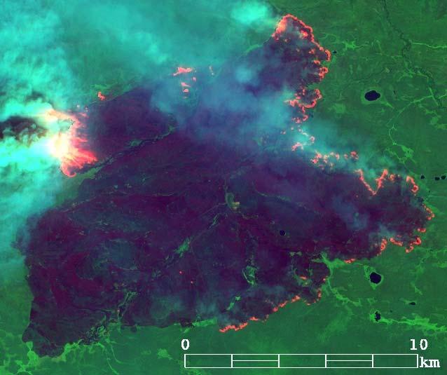
15 Fire


16 Burnt forest 25 million ha

17 Timber harvest

18


19
20


21 4/18/2006 Olga N. Krankina, OSU

22 Each stack of images included 3-4 dates (or layers)
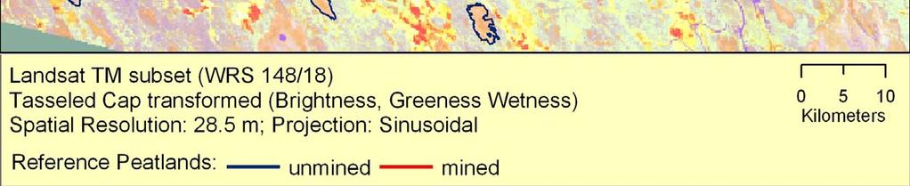
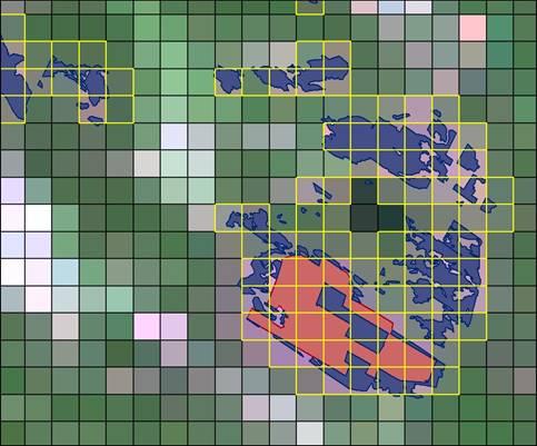
23 Disturbance Index Transformation 3 Band Tasseled Cap Image Standardized with reference to its mean value Disturbance Index Transformation Brightness (Greenness + Wetness) = Disturbance Index Recently disturbed forests exhibit a higher brightness reflectance value, while greenness and wetness are typically lower.

24 Multi-Temporal Disturbance Image Disturbance indices for each date combined into a multitemporal image

25 Classification of disturbed sites by time intervals 300 Cut no change cut cut disturbance index Undisturbed Cut
26 Location of NELDA test sites (Map was created at EC JRC as part of GLC 2000 project, Bartalev et al. 2003) 4/18/2006 Olga N. Krankina, OSU
27 Prospective new NELDA sites 14 additional sites proposed Cover additional vegetation types and regions within Northern Eurasia

28
29 Development of a New Land Cover Map of Northern Eurasia Using MODIS Objective: Use MODIS data in association with site data to create a map circa ~2005 Motivation: Provide best possible information regarding baseline land cover; support for studies of change Approach Modify MOD12 algorithm for regional processing Refine & augment MODIS site database Use LCCS classification system Validate using network of test sites
30 Training Site Development Live Database ~ 2300 sites globally Northern Eurasia: ~200 sites Will refine and augment in support of LCCS w/help from Russian collaborators (distinct from test sites)
31 MODIS Land Cover Processing Chain MODIS Data: Temporal and spectral information 32-day composites 500 m Inputs Surface Reflectance (NBAR) View-angle corrected surface reflectance 7 land bands Enhanced Vegetation Index (EVI) Computed from NBARs Annual Metrics Min, max, mean for each band, plus EVI Extract Exemplars From Training Site Database Estimate Classification Apply Classification to Northern Eurasia Post-Processing via Priors & Bayes Rule New Map
32 Expected results 15 test sites MODIS-derived disturbance/ land-cover change map for Northern Eurasia for the period New regional land-cover map Strengthen the user community and serve as basis for future projects
7/8/2010 Olga N. Krankina, OSU
 Northern Eurasia Regional Information Network Olga N. Krankina Department of Forest Science Oregon State University Motivation Northern Eurasia (NE) is the largest landmass, the largest terrestrial reservoir
Final Report. NELDA: Monitoring and Validating the Distribution and Change in Land Cover across Northern Eurasia
 Final Report NASA Grant Number NNG06GF54G 3/15/2006 to 3/14/2010 NELDA: Monitoring and Validating the Distribution and Change in Land Cover across Northern Eurasia Principal Investigator: Co-Investigators:
Regional Networks and NASA LCLUC Program
 Global Observation of Forest and Land Cover Dynamics Regional Networks and NASA LCLUC Program Dr. Olga Krankina College of Forestry, Oregon State University GOFC-GOLD Regional Networks Coordinator with
Overview on Land Cover and Land Use Monitoring in Russia
 Russian Academy of Sciences Space Research Institute Overview on Land Cover and Land Use Monitoring in Russia Sergey Bartalev Joint NASA LCLUC Science Team Meeting and GOFC-GOLD/NERIN, NEESPI Workshop
Overview of GOFC-GOLD Regional Networks
 Global Observation of Forest and Land Cover Dynamics Overview of GOFC-GOLD Regional Networks Dr. Olga N. Krankina College of Forestry, Oregon State University, USA GOFC-GOLD Regional Networks Coordinator
GOFC-GOLD Regional Networks and Central Asia
 Global Observation of Forest and Land Cover Dynamics GOFC-GOLD Regional Networks and Central Asia Dr. Olga N. Krankina College of Forestry, Oregon State University, USA GOFC-GOLD Regional Networks Coordinator
AGOG 485/585 /APLN 533 Spring Lecture 5: MODIS land cover product (MCD12Q1). Additional sources of MODIS data
. Additional sources of MODIS data") AGOG 485/585 /APLN 533 Spring 2019 Lecture 5: MODIS land cover product (MCD12Q1). Additional sources of MODIS data Outline Current status of land cover products Overview of the MCD12Q1 algorithm Mapping
AGOG 485/585 /APLN 533 Spring 2019 Lecture 5: MODIS land cover product (MCD12Q1). Additional sources of MODIS data Outline Current status of land cover products Overview of the MCD12Q1 algorithm Mapping
Report on: UNESCO Joint Training Course:
 Report on: UNESCO Joint Training Course: Geospatial Methods, Technologies, and Applications in Monitoring Land Cover, Land Use, Fire and Water in semi-arid regions Central Asia Jointly with NASA LCLUC
GCOS High Resolution Land Cover ECV. Slide 11
 GCOS High Resolution Land Cover ECV Slide 11 Detailed Land Cover and Climate Land cover and its changes modify the goods and services provided to human society force climate by altering water and energy
SIRS NEESPI megaproject :
 SIRS NEESPI megaproject : results and perspectives July 15, 2009 E. Gordov (1,2), M. Kabanov (2), V. Lykosov (3) and E. Vaganov (4) Siberian Center for Environmental research and Training, Tomsk, Russia,
ANALYSIS AND VALIDATION OF A METHODOLOGY TO EVALUATE LAND COVER CHANGE IN THE MEDITERRANEAN BASIN USING MULTITEMPORAL MODIS DATA
 PRESENT ENVIRONMENT AND SUSTAINABLE DEVELOPMENT, NR. 4, 2010 ANALYSIS AND VALIDATION OF A METHODOLOGY TO EVALUATE LAND COVER CHANGE IN THE MEDITERRANEAN BASIN USING MULTITEMPORAL MODIS DATA Mara Pilloni
Data Fusion and Multi-Resolution Data
 Data Fusion and Multi-Resolution Data Nature.com www.museevirtuel-virtualmuseum.ca www.srs.fs.usda.gov Meredith Gartner 3/7/14 Data fusion and multi-resolution data Dark and Bram MAUP and raster data Hilker
Access to global land cover reference datasets and their suitability for land cover mapping activities
 Access to global land cover reference datasets and their suitability for land cover mapping activities Brice Mora, N.E.Tsendbazar, M.Herold LPVE meeting, Frascati, January 29, 2014 Outlook 1. Background
Land cover research, applications and development needs in Slovakia
 Land cover research, applications and development needs in Slovakia Andrej Halabuk Institute of Landscape Ecology Slovak Academy of Sciences (ILE SAS) Štefánikova 3, 814 99 Bratislava, Slovakia Institute
Detecting Landscape Changes in High Latitude Environments Using Landsat Trend Analysis: 2. Classification
 1 Detecting Landscape Changes in High Latitude Environments Using Landsat Trend Analysis: 2. Classification Ian Olthof and Robert H. Fraser Canada Centre for Mapping and Earth Observation Natural Resources
Monitoring land cover, land use and fire in agricultural and semi-arid regions of Northern Eurasia
 Joint NASA LCLUC Science Team Meeting and GOFC-GOLD/NERIN, NEESPI, MAIRS Workshop Monitoring land cover, land use and fire in agricultural and semi-arid regions of Northern Eurasia September 15-19, 2009
Climatic and Ecological Conditions in the Klamath Basin of Southern Oregon and Northern California: Projections for the Future
 Climatic and Ecological Conditions in the Klamath Basin of Southern Oregon and Northern California: Projections for the Future A Collaborative Effort by: CLIMATE LEADERSHIP INITIATIVE INSTITUTE FOR A SUSTAINABLE
Capabilities and Limitations of Land Cover and Satellite Data for Biomass Estimation in African Ecosystems Valerio Avitabile
 Capabilities and Limitations of Land Cover and Satellite Data for Biomass Estimation in African Ecosystems Valerio Avitabile Kaniyo Pabidi - Budongo Forest Reserve November 13th, 2008 Outline of the presentation
Mapping forests in monsoon Asia with ALOS PALSAR 50-m mosaic images and MODIS
 1 Supplementary Information 2 3 Mapping forests in monsoon Asia with ALOS PALSAR 50-m mosaic images and MODIS imagery in 2010 4 5 6 7 8 9 10 11 Yuanwei Qin, Xiangming Xiao, Jinwei Dong, Geli Zhang, Partha
Assimilating terrestrial remote sensing data into carbon models: Some issues
 University of Oklahoma Oct. 22-24, 2007 Assimilating terrestrial remote sensing data into carbon models: Some issues Shunlin Liang Department of Geography University of Maryland at College Park, USA Sliang@geog.umd.edu,
USAGE AND PLANS OF HOTSPOT INFORMATION IN INDONESIA
 USAGE AND PLANS OF HOTSPOT INFORMATION IN INDONESIA Orbita Roswintiarti Natural Resources and Environmental Monitoring Division Indonesian National Institute of Aeronautics and Space (LAPAN) http://www.rs
Module 2.1 Monitoring activity data for forests using remote sensing
 Module 2.1 Monitoring activity data for forests using remote sensing Module developers: Frédéric Achard, European Commission (EC) Joint Research Centre (JRC) Jukka Miettinen, EC JRC Brice Mora, Wageningen
LAND COVER CATEGORY DEFINITION BY IMAGE INVARIANTS FOR AUTOMATED CLASSIFICATION
 LAND COVER CATEGORY DEFINITION BY IMAGE INVARIANTS FOR AUTOMATED CLASSIFICATION Nguyen Dinh Duong Environmental Remote Sensing Laboratory Institute of Geography Hoang Quoc Viet Rd., Cau Giay, Hanoi, Vietnam
Greening of Arctic: Knowledge and Uncertainties
 Greening of Arctic: Knowledge and Uncertainties Jiong Jia, Hesong Wang Chinese Academy of Science jiong@tea.ac.cn Howie Epstein Skip Walker Moscow, January 28, 2008 Global Warming and Its Impact IMPACTS
What is GOFC-GOLD? GOFC-GOLD is a coordinated international effort:
 What is GOFC-GOLD? GOFC-GOLD is a coordinated international effort: to ensure a continuous program of space-based and on-the-ground forest and land cover observations for global monitoring of terrestrial
Deriving Landcover Information over Siberia using MERIS and MODIS data
 Deriving Landcover Information over Siberia using MERIS and data Dr Laine Skinner (1) and Dr Adrian Luckman (1) (1) University of Wales Swansea, Singleton Park, SA2 8PP Swansea, UK. gglskinn@swan.ac.uk
Patrick Leinenkugel. German Aerospace Center (DLR) Vortrag > Autor > Dokumentname > Datum
 Vortrag > Autor > Dokumentname > Datum") Characterisation of land surface phenology and land cover for the Mekong Basin on the basis of multitemporal and multispectral satellite data from the MODIS Sensor Patrick Leinenkugel German Aerospace
Characterisation of land surface phenology and land cover for the Mekong Basin on the basis of multitemporal and multispectral satellite data from the MODIS Sensor Patrick Leinenkugel German Aerospace
Methods review for the Global Land Cover 2000 initiative Presentation made by Frédéric Achard on November 30 th 2000
 Methods review for the Global Land Cover 2000 initiative Presentation made by Frédéric Achard on November 30 th 2000 1. Contents Objectives Specifications of the GLC-2000 exercise Strategy for the analysis
Land abandonment and recultivation in Central and Eastern Europe
 Land abandonment and recultivation in Central and Eastern Europe Patrick Hostert Patrick Griffiths, Stephan Estel, Camilo Alcantara, Tobias Kuemmerle, Dirk Pflugmacher, Alexander Prishchepov, Volker Radeloff
A.M.Obukhov Institute of Atmospheric Physics RAS A.M.Obukhov Institute of Atmospheric Physics RAS A.M.Obukhov Institute of Atmospheric Physics RAS
 SESSION Pan-Eurasian Experiment (PEEX) A Research Initiative Meeting «The Grand Challenges Of The Changing Environment Of The Northern Pan-Eurasian Arctic-Boreal Areas» Wednesday, 19.08.2015 Chairs of
NASA MODIS and VIIRS Burned Area Products Update
 NASA MODIS and VIIRS Burned Area Products Update Louis Giglio, Luigi Bosche@, Michael Humber, William Walsh, David Roy, Christopher JusIce GOFC Fire Implementa0on Team Mee0ng November 2016 MODIS Burned
Using satellite images to calculate land use and land cover statistics
 Using satellite images to calculate land use and land cover statistics National Administrative Department of Statistics DANE Colombia April 2016 @DANE_Colombia /DANEColombia /DANEColombia Background (1)
the earth observer Editor s Corner Steve Platnick EOS Senior Project Scientist The Earth Observer. September - October Volume 24, Issue 5.
 National Aeronautics and Space Administration The Earth Observer. September - October 2012. Volume 24, Issue 5. A valued member of the Earth Observing System (EOS) and the Terra team is leaving NASA. Marc
RedLatif Latin American Network of Remote Sensing and Forest Fire Sun City, South Africa Maria Isabel Cruz Lopez May 9th, 2011 RedLatif Coordinator
 RedLatif Latin American Network of Remote Sensing and Forest Fire Sun City, South Africa May 9 th, 2011 Maria Isabel Cruz Lopez RedLatif Coordinator Index 1.- Objective 2.- Members 3.- WEB page 4.- Projects
Land Cover Project ESA Climate Change Initiative. Processing chain for land cover maps dedicated to climate modellers.
 Land Cover Project ESA Climate Change Initiative Processing chain for land cover maps dedicated to climate modellers land_cover_cci S. Bontemps 1, P. Defourny 1, V. Kalogirou 2, F.M. Seifert 2 and O. Arino
Satellite Constraints on Arctic-region Airborne Particles Ralph Kahn NASA Goddard Space Flight Center
 Satellite Constraints on Arctic-region Airborne Particles Ralph Kahn NASA Goddard Space Flight Center Sea of Okhotsk, MODIS image Feb. 6, 2007, NASA Earth Observatory Arctic Aerosol Remote Sensing Overview
Ecosystem Disturbance and
 Remote Sensing of Forest Health: Ecosystem Disturbance and Recovery Tracker (edart) Region 5 Remote Sensing Lab Michèle Slaton, Alex Koltunov, Carlos Ramirez edart Overview A group of automated and interactive
Dynamic Land Cover Dataset Product Description
 Dynamic Land Cover Dataset Product Description V1.0 27 May 2014 D2014-40362 Unclassified Table of Contents Document History... 3 A Summary Description... 4 Sheet A.1 Definition and Usage... 4 Sheet A.2
Impact of NASA EOS data on the scientific literature: 16 years of published research results from Terra, Aqua, Aura, and Aquarius
 Impact of NASA EOS data on the scientific literature: 16 years of published research results from Terra, Aqua, Aura, and Aquarius Gene R. Major NASA Goddard Library Nebulous Connections April 4, 2017 RESACs/RA
Kyoto and Carbon Initiative - the Ramsar / Wetlands International perspective
 Kyoto and Carbon Initiative - the Ramsar / Wetlands International perspective (the thoughts of Max Finlayson, as interpreted by John Lowry) Broad Requirements Guideline(s) for delineating wetlands (specifically,
K&C Phase 4 Status report. Use of short-period ALOS-2 observations for vegetation characterization and classification
 K&C Phase 4 Status report Use of short-period ALOS-2 observations for vegetation characterization and classification Paul Siqueira, Tracy Whelen University of Massachusetts, Amherst Yang Lei NASA JPL Science
Remote sensing of the terrestrial ecosystem for climate change studies
 Frontier of Earth System Science Seminar No.1 Fall 2013 Remote sensing of the terrestrial ecosystem for climate change studies Jun Yang Center for Earth System Science Tsinghua University Outline 1 Introduction
A Global Water Budget Assessment
 A Global Water Budget Assessment C. Adam Schlosser and Xiang Gao Joint Program on the Science and Policy of Global Change (JP Tech. Report #179, and accepted with minor revisions to J. of Hydrometeorology)
A Regional Database Tracking Fire Footprint Each Year within the South Atlantic Region: Current Database Description and Future Directions
 A Regional Database Tracking Fire Footprint Each Year within the South Atlantic Region: Current Database Description and Future Directions Last Updated on September 30, 2018 Contributors: NatureServe,
Application and impacts of the GlobeLand30 land cover dataset on the Beijing Climate Center Climate Model
 IOP Conference Series: Earth and Environmental Science PAPER OPEN ACCESS Application and impacts of the GlobeLand30 land cover dataset on the Beijing Climate Center Climate Model To cite this article:
The Wide Dynamic Range Vegetation Index and its Potential Utility for Gap Analysis
 Summary StatMod provides an easy-to-use and inexpensive tool for spatially applying the classification rules generated from the CT algorithm in S-PLUS. While the focus of this article was to use StatMod
DEVELOP National Program
 DEVELOP National Program GLSLCI 2015 Annual Meeting and Conference Sarnia, Ontario 19 June 2015 DEVELOP National Program NASA GLSLCI 2015 June 2015 NASA Earth observations NASA Earth observations include
Elsevier Editorial System(tm) for Remote Sensing of Environment Manuscript Draft
 for Remote Sensing of Environment Manuscript Draft") Elsevier Editorial System(tm) for Remote Sensing of Environment Manuscript Draft Manuscript Number: Title: Hierarchical Mapping of Northern Eurasian Land Cover Article Type: Full length article Keywords:
Elsevier Editorial System(tm) for Remote Sensing of Environment Manuscript Draft Manuscript Number: Title: Hierarchical Mapping of Northern Eurasian Land Cover Article Type: Full length article Keywords:
Introduction to Satellite Derived Vegetation Indices
 Introduction to the Use of Geospatial Information Technology for Drought Risk Management 13-17 November, 2017 Tonle Bassac II Restaurant, Phnom Penh, Cambodia Introduction to Satellite Derived Vegetation
Mapping Global Urban Area from DMSP/OLS Nightlights using a Cluster-based Method
 Mapping Global Urban Area from DMSP/OLS Nightlights using a Cluster-based Method Y. ZHOU, S. SMITH, A. THOMSON, B. BOND-LAMBERTY, M. IMHOFF K. ZHAO, C. ELVIDGE, J. EOM, K. CLARKE Joint Global Change Research
APPENDIX. Normalized Difference Vegetation Index (NDVI) from MODIS data
 from MODIS data") APPENDIX Land-use/land-cover composition of Apulia region Overall, more than 82% of Apulia contains agro-ecosystems (Figure ). The northern and somewhat the central part of the region include arable lands
APPENDIX Land-use/land-cover composition of Apulia region Overall, more than 82% of Apulia contains agro-ecosystems (Figure ). The northern and somewhat the central part of the region include arable lands
The use of spatial-temporal analysis for noise reduction in MODIS NDVI time series data
 The use of spatial-temporal analysis for noise reduction in MODIS NDVI time series data Julio Cesar de Oliveira 1,2, José Carlos Neves Epiphanio 1, Camilo Daleles Rennó 1 1 Instituto Nacional de Pesquisas
ZRCSAZU. Remote sensing and Earth observation data at ZRC SAZU. dr. Tatjana Veljanovski Atrij ZRC Ljubljana
 ZRCSAZU Remote sensing and Earth observation data at ZRC SAZU dr. Tatjana Veljanovski 2016-06-08 Atrij ZRC Ljubljana Remote Sensing Department Remote Sensing Department 20 years of experience application,
Understanding the role of land cover / land use nexus in malaria transmission under changing socio-economic climate in Myanmar
 Annual Report for Year 1 June, 2017 January, 2018 NASA Land Cover Land Use Change Program Funded under grant # NNX17AI06G: Understanding the role of land cover / land use nexus in malaria transmission
Comparison between Land Surface Temperature Retrieval Using Classification Based Emissivity and NDVI Based Emissivity
 Comparison between Land Surface Temperature Retrieval Using Classification Based Emissivity and NDVI Based Emissivity Isabel C. Perez Hoyos NOAA Crest, City College of New York, CUNY, 160 Convent Avenue,
DUC 2017 Fieldwork Overview: Akaitcho Wetland Mapping Project
 DUC 2017 Fieldwork Overview: Akaitcho Wetland Mapping Project Prepared for MobileDemand Project Managers: Kevin Smith, Al Richard Lead Technical Analyst: *Michael Merchant Support Analysts: Becca Warren,
Programme. MC : Byron Anangwe. Morning Session
 Programme MC : Byron Anangwe Morning Session DAY 2 Summary MC : Byron Anangwe The USGS global land cover mapping initiative Land use and land cover mapping at the Joint Research Centre Alan Belward FAO
Static Water Fraction
 Soil Moisture Active Passive (SMAP) Ancillary Data Report Static Water Fraction Preliminary, v.2 SMAP Science Document no. 045 Steven Chan Jet Propulsion Laboratory California Institute of Technology Pasadena,
Building a validation database for land cover products from high spatial resolution images
 Building a validation database for land cover products from high spatial resolution images The Land Cover project of the ESA Climate Change Initiative Bontemps Sophie 1, Achard Frédéric 2, Lamarche Céline
A Facility for Producing Consistent Remotely Sensed Biophysical Data Products of Australia
 TERRESTRIAL ECOSYSTEM RESEARCH NETWORK - AusCover - A Facility for Producing Consistent Remotely Sensed Biophysical Data Products of Australia June, 2011 Mervyn Lynch Professor of Remote Sensing Curtin
Global land cover maps validation: current strategy for CCI Land Cover
 THE LAND COVER COMPONENT OF THE ESA CLIMATE CHANGE INITIATIVE Global land cover maps validation: current strategy for CCI Land Cover Defourny P. (1), Brockmann C. (3), Bontemps S. (1), Achard F. (2), Boettcher
Identifying Audit, Evidence Methodology and Audit Design Matrix (ADM)
") 11 Identifying Audit, Evidence Methodology and Audit Design Matrix (ADM) 27/10/2012 Exercise XXX 2 LEARNING OBJECTIVES At the end of this session participants will be able to: 1. Identify types and sources
11 Identifying Audit, Evidence Methodology and Audit Design Matrix (ADM) 27/10/2012 Exercise XXX 2 LEARNING OBJECTIVES At the end of this session participants will be able to: 1. Identify types and sources
THE production of global land cover datasets is vital for
 1740 IEEE TRANSACTIONS ON GEOSCIENCE AND REMOTE SENSING, VOL. 44, NO. 7, JULY 2006 A Method to Compare and Improve Land Cover Datasets: Application to the GLC-2000 and MODIS Land Cover Products Linda M.
choice have on a particular application? For example, Fritz et al. (2010a) have shown that comparing global land cover (GLC-2000) with the equivalent
 have shown that comparing global land cover (GLC-2000) with the equivalent") Improving Global Land Cover through Crowd-sourcing and Map Integration L. See 1, S. Fritz 1, I. McCallum 1, C. Schill 2, C. Perger 3 and M. Obersteiner 1 1 International Institute for Applied Systems Analysis
Improving Global Land Cover through Crowd-sourcing and Map Integration L. See 1, S. Fritz 1, I. McCallum 1, C. Schill 2, C. Perger 3 and M. Obersteiner 1 1 International Institute for Applied Systems Analysis
Permanent Ice and Snow
 Soil Moisture Active Passive (SMAP) Ancillary Data Report Permanent Ice and Snow Preliminary, v.1 SMAP Science Document no. 048 Kyle McDonald, E. Podest, E. Njoku Jet Propulsion Laboratory California Institute
Geo-spatial Statistics with Globalland30
 UN International Workshop on Integrating Geospatial and Statistical Information Geo-spatial Statistics with Globalland30 Jun Chen 1,2 Lijun Chen 1, Ran Li 1 1 National Geomatics Center, China 2 International
Validating a Satellite Microwave Remote Sensing Based Global Record of Daily Landscape Freeze- Thaw Dynamics
 University of Montana ScholarWorks at University of Montana Numerical Terradynamic Simulation Group Publications Numerical Terradynamic Simulation Group 2012 Validating a Satellite Microwave Remote Sensing
Supporting Information for
 Supporting Information for Surface urban heat island across 19 global big cities Shushi Peng 1, Shilong Piao 1*, Philippe Ciais, Pierre Friedlingstein 3, Catherine Ottle, François-Marie Bréon, Ranga B.
What is a vegetation index?
 Vegetation indexes What is a vegetation index? A tool: a vegetation index is a mathematical formula used to estimate the likelihood of vegetation presence in remotely sensed data A product: the result
Interdisciplinary research for carbon cycling in a forest ecosystem and scaling to a mountainous landscape in Takayama,, central Japan.
 Asia-Pacific Workshop on Carbon Cycle Observations (March 17 19, 2008) Interdisciplinary research for carbon cycling in a forest ecosystem and scaling to a mountainous landscape in Takayama,, central Japan.
USING HYPERSPECTRAL IMAGERY
 USING HYPERSPECTRAL IMAGERY AND LIDAR DATA TO DETECT PLANT INVASIONS 2016 ESRI CANADA SCHOLARSHIP APPLICATION CURTIS CHANCE M.SC. CANDIDATE FACULTY OF FORESTRY UNIVERSITY OF BRITISH COLUMBIA CURTIS.CHANCE@ALUMNI.UBC.CA
West meets East: Monitoring and modeling urbanization in China Land Cover-Land Use Change Program Science Team Meeting April 3, 2012
 West meets East: Monitoring and modeling urbanization in China Land Cover-Land Use Change Program Science Team Meeting April 3, 2012 Annemarie Schneider Center for Sustainability and the Global Environment,
SUPPORTING INFORMATION. Ecological restoration and its effects on the
 SUPPORTING INFORMATION Ecological restoration and its effects on the regional climate: the case in the source region of the Yellow River, China Zhouyuan Li, Xuehua Liu,* Tianlin Niu, De Kejia, Qingping
Land Surface Remote Sensing II
 PROCEEDINGS OFSPIE Land Surface Remote Sensing II Thomas J. Jackson Jing Ming Chen Peng Gong Shunlin Liang Editors 13-16 October 2014 Beijing, China Sponsored by SPIE Cosponsored by State Key Laboratory
Defourny P. (1), Bontemps S. (1), Brockmann C. (3), Achard F. (2), Boettcher M. (3), De Maet T. (1), Land_Cover_CCI
, Bontemps S. (1), Brockmann C. (3), Achard F. (2), Boettcher M. (3), De Maet T. (1), Land_Cover_CCI") Defourny P. (1), Bontemps S. (1), Brockmann C. (3), Achard F. (2), Boettcher M. (3), De Maet T. (1), Land_Cover_CCI Gamba P. (4), Hagemann S. (5), Hartley A. (6), Hoffman L., (11), Khlystova I.G. (5),
Defourny P. (1), Bontemps S. (1), Brockmann C. (3), Achard F. (2), Boettcher M. (3), De Maet T. (1), Land_Cover_CCI Gamba P. (4), Hagemann S. (5), Hartley A. (6), Hoffman L., (11), Khlystova I.G. (5),
Research Proposal Global Change in Photosynthesis Moumita Dutta Gupta ~ GGR 904 May 5 th 2009
 Research Proposal Global Change in Photosynthesis 1982 2008 Moumita Dutta Gupta ~ GGR 904 May 5 th 2009 ?? -The Question - How and where is Global Photosynthesis changing as captured by the SPOT VEGETATION
Overview of Remote Sensing in Natural Resources Mapping
 Overview of Remote Sensing in Natural Resources Mapping What is remote sensing? Why remote sensing? Examples of remote sensing in natural resources mapping Class goals What is Remote Sensing A remote sensing
Remote Sensing Based Inversion of Gap Fraction for Determination of Leaf Area Index. Alemu Gonsamo 1 and Petri Pellikka 1
 Remote Sensing Based Inversion of Gap Fraction for Determination of Leaf Area Index Alemu Gonsamo and Petri Pellikka Department of Geography, University of Helsinki, P.O. Box, FIN- Helsinki, Finland; +-()--;
Seasonal and interannual relations between precipitation, soil moisture and vegetation in the North American monsoon region
 Seasonal and interannual relations between precipitation, soil moisture and vegetation in the North American monsoon region Luis A. Mendez-Barroso 1, Enrique R. Vivoni 1, Christopher J. Watts 2 and Julio
Ryan Baum, MS Candidate, ISU Matthew Germino, Assistant Professor, ISU
 Spatial and temporal variation in remotely sensed vegetation indices on the INEEL from 1984-2002 Ryan Baum, MS Candidate, ISU Matthew Germino, Assistant Professor, ISU Importance How does vegetation vary
WIGOS Metadata Standard: Satellite Community Update
 WIGOS Metadata Standard: Satellite Community Update IPET-SUP-2 Luís Nunes WIGOS Project Office WMO; OBS/WIGOS Contents The WIGOS Metadata Standard (WMDS) - background The outcomes and actions from the
Leveraging Sentinel-1 time-series data for mapping agricultural land cover and land use in the tropics
 Leveraging Sentinel-1 time-series data for mapping agricultural land cover and land use in the tropics Caitlin Kontgis caitlin@descarteslabs.com @caitlinkontgis Descartes Labs Overview What is Descartes
COMPARING GLOBAL LAND COVER DATASETS THROUGH THE EAGLE MATRIX LAND COVER COMPONENTS FOR CONTINENTAL PORTUGAL. Selçuk Mozak
 COMPARING GLOBAL LAND COVER DATASETS THROUGH THE EAGLE MATRIX LAND COVER COMPONENTS FOR CONTINENTAL PORTUGAL Selçuk Mozak COMPARING GLOBAL LAND COVER DATASETS THROUGH THE EAGLE MATRIX LAND COVER COMPONENTS
HYDROMETEOROLOGICAL DATABASE (HMDB) FOR PRACTICAL RESEARCH IN ECOLOGY
 FOR PRACTICAL RESEARCH IN ECOLOGY") HYDROMETEOROLOGICAL DATABASE (HMDB) FOR PRACTICAL RESEARCH IN ECOLOGY A Novakovskiy 1 * and V Elsakov 1 1 Laboratory of Computer Technology and Modeling, Institute of Biology, Komi Science Centre, Ural
HYDROMETEOROLOGICAL DATABASE (HMDB) FOR PRACTICAL RESEARCH IN ECOLOGY A Novakovskiy 1 * and V Elsakov 1 1 Laboratory of Computer Technology and Modeling, Institute of Biology, Komi Science Centre, Ural
LARGE AREA LAND COVER CLASSIFICATION WITH LANDSAT ETM+ IMAGES BASED ON DECISION TREE
 LARGE AREA LAND COVER CLASSIFICATION WITH LANDSAT ETM+ IMAGES BASED ON DECISION TREE Liang ZHAI, Jinping SUN, Huiyong SANG, Gang YANG, Yi JIA Key Laboratory of Geo-Informatics of NASG, Chinese Academy
Predicting ectotherm disease vector spread. - Benefits from multi-disciplinary approaches and directions forward
 Predicting ectotherm disease vector spread - Benefits from multi-disciplinary approaches and directions forward Naturwissenschaften Stephanie Margarete THOMAS, Carl BEIERKUHNLEIN, Department of Biogeography,
Mining Climate Data. Michael Steinbach Vipin Kumar University of Minnesota /AHPCRC
 Mining Climate Data Michael Steinbach Vipin Kumar University of Minnesota /AHPCRC Collaborators: G. Karypis, S. Shekhar (University of Minnesota/AHPCRC) V. Chadola, S. Iyer, G. Simon, P. Zhang (UM/AHPCRC)
Current LCLUC challenges in SCERIN: Assessing Ecosystem Function and Processes
 Summary of the SCERIN 2 meeting Current LCLUC challenges in SCERIN: Assessing Ecosystem Function and Processes Katarzyna Ostapowicz Department of GIS, Cartography and Remote Sensing, Institute of Geography
Impacts of sensor noise on land cover classifications: sensitivity analysis using simulated noise
 Impacts of sensor noise on land cover classifications: sensitivity analysis using simulated noise Scott Mitchell 1 and Tarmo Remmel 2 1 Geomatics & Landscape Ecology Research Lab, Carleton University,
Pan-Arctic, Regional and Local Land Cover Products
 Pan-Arctic, Regional and Local Land Cover Products Marcel Urban (1), Stefan Pöcking (1), Sören Hese (1) & Christiane Schmullius (1) (1) Friedrich-Schiller University Jena, Department of Earth Observation,
Advanced Image Analysis in Disaster Response
 Advanced Image Analysis in Disaster Response Creating Geographic Knowledge Thomas Harris ITT The information contained in this document pertains to software products and services that are subject to the
Arctic Tundra land cover and biomass change on the Central Yamal peninsula, Russia
 Arctic Tundra land cover and biomass change on the Central Yamal peninsula, Russia ArcticBiomass Workshop, 20-23 Ocrobertember 2015, Svalbard Kumpula, T.*, Verdonen, M*., Macias-Fauria, M***, Skarin A.****
The Soil Atlas of the Northern Circumpolar Region
 Conference Soil, Climate Change and Biodiversity Where do we stand? Brussels, Thursday 23rd and Friday 24th September 2010 1 The Soil Atlas of the Northern Circumpolar Region Luca Montanarella European
INTERNATIONAL EARTH OBSERVATION INITIATIVES AND PROGRAMS: THE CONTEXT FOR GLOBAL URBAN MAPPING
 INTERNATIONAL EARTH OBSERVATION INITIATIVES AND PROGRAMS: THE CONTEXT FOR GLOBAL URBAN MAPPING Martin Herold a and Christiane C. Schmullius a a ESA GOFC-GOLD Land Cover Project Office, Dep. of Geography,
Forest Service Suppression Cost Forecasts and Simulation Forecast for Fiscal Year 2010 Spring Update
 Forest Service Suppression Cost Forecasts and Simulation Forecast for Fiscal Year 2010 Spring Update Jeffrey P. Prestemon, Southern Research Station, Forest Service Krista Gebert, Rocky Mountain Research
Monitoring vegetation activity in Hungary using Direct Broadcast MODIS data
 Monitoring vegetation activity in Hungary using Direct Broadcast MODIS data Anikó Kern1 Contributors: Szilárd Pásztor1, Péter Bognár1, Zoltán Barcza2, Gábor Timár1, János Lichtenberger1, Péter Steinbach3,
SCERIN Overview SCERIN-4 Goals and Workshop Agenda
 The GOFC-GOLD South Central and Eastern European Network (SCERIN) SCERIN Overview SCERIN-4 Goals and Workshop Agenda Petya Campbell 1, Jana Albrechtová 2 and Lucie Kupková 2 1 Joint Center for Earth Systems
Extending the Deep Blue aerosol record from SeaWiFS and MODIS to NPP-VIIRS
 Extending the Deep Blue aerosol record from SeaWiFS and MODIS to NPP-VIIRS Andrew M. Sayer, N. Christina Hsu (PI), Corey Bettenhausen, Jaehwa Lee Climate & Radiation Laboratory, NASA Goddard Space Flight
Global Observation of Forest and Land Cover Dynamics Towards Operational Land Cover and Fire Observations
 Global Observation of Forest and Land Cover Dynamics Towards Operational Land Cover and Fire Observations Michael Brady Executive Director GOFC-GOLD Joint Meeting on Land Cover/Land Use Change Processes