Arctic Tundra land cover and biomass change on the Central Yamal peninsula, Russia
|
|
|
- Shanon Webb
- 5 years ago
- Views:
Transcription

 (Finnish")
1 Arctic Tundra land cover and biomass change on the Central Yamal peninsula, Russia ArcticBiomass Workshop, Ocrobertember 2015, Svalbard Kumpula, T.*, Verdonen, M*., Macias-Fauria, M***, Skarin A.**** & B. Forbes** *Department Of Geographical and historical studies, University of Eastern Finland ** Arctic Centre, University of Lapland *** Department of GeographybUniversity of Oxford, ****University of Uppsala, Sweden Past and ongoing projects Study of petroleum explorations impacts to reindeer herding: Environmental and Social Impacts of Industrialization in Northern Russia (ENSINOR) (Finnish Academy ) in YNAO and NAO (Bruce Forbes) NASA LULCC project: Land-cover and Land-use Changes on the Yamal Peninsula, Russia (Skip Walker) ( ) Resilience in Social-Ecological Systems of Northwest Eurasia RISES (Finnish Academy ) (Bruce Forbes) NASA LULCC project: Yamal LCLUC Synthesis: A synthesis of remote-sensing studies, ground observations and modeling to understand the social-ecological consequences of climate change and resource development on the Yamal Peninsula, Russia and relevance to the circumpolar Arctic (Skip Walker) ( ) Terra XS data Project: Combining remote sensing and field studies for assessment of landform dynamics and permafrost state on Yamal (Annett Bartsch) 1
 anthropogenic: petroleum related expansion of")

2 Research sites in Yamal July 2004, 2005, 2011, 2014, Bovanenkovo, Mordy-jaha - Yuribei river - Laboravaja July 2010, 2013, 2014 July 2007 Drivers of land cover and land use change on Yamal: 1) anthropogenic: petroleum related expansion of infrastructure and traffic 2) natural: climate change related, changes in vegetation, intensification of permafrost melting related processes, e.g. cryogenic landslides and thawing lakes 3) anthropogenic-natural: intensification of reindeer husbandry, impact to vegetation 2


3 Kumpula et al. (2012) Remote sensing 3


4 Remote sensing data Corona 1969 KH Aerial photographs s Landsat TM August Landsat MSS July Landsat TM August SPOT July SPOT July Landsat ETM 1999 July Landsat ETM 2001 July ASTER TERRA July Quickbird /28 July Landsat TM 2009 July Landsat TM July Landsat ETM July Worldview July Landsat 2014 July Terra XS 2014 July ALOS prism DEM 2007 MODIS 4


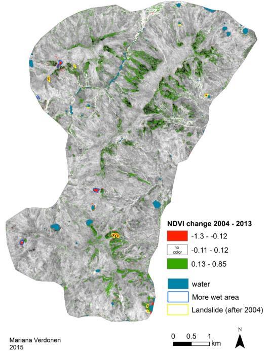
5 Lancover classification of Yarsalinksi sovkhoze summer and autumn pastures Landsat TM data 1988 & > change detection -> reindeer use of pastures (GPS) data -> reindeer shrub - interaction 2001 MODIS NDVI 2014 MODIS NDVI difference: - Red decrease in NDVI - Green increase in NDVI 5


6


7 KH Landsat lakes disappeared or shrinked 4 new lakes 7


 Landslide willow (salix) dynamics")
 Landform dynamics, eg.")

8 Landslides in central Yamal, Mapping of landslides with remote sensing The key research area is located on west bank of Mordy-jaha river where landslides can be found along the north-south ridge which is about 20 km long and 2-4 km width In late 1980 s occurred a major landslide event Focus of the research Landslide detection from optical multispectral and multiscale remote sensing imagery Field data collection of spectral characteristics (ASD spectometer) Landslide willow (salix) dynamics (dendrochronology, biomass, Leaf Area Index LAI 2200) Landform dynamics, eg. lakes TerraXS data analysis: landslide slope charateristics, willow thickets Combining TerraXS with optical RS data analysis Anthropogenic disturbance 8

 landslides are clearly detectable.")


9 About 400 landslides About 800 landslides KH-9 image 1976,Landsat TM image from 1988 shows rigde with no recent landslides. From SPOT image (1993) landslides are clearly detectable. By 2011 vegetation succession process has advanced so that from Landsat TM imagery landslides have become difficult to distinquish We detected about 800 landslides in our research area in Central Yamal which occurred in late 1980 s and 400 in early 1970 s 9


10 NDVI change Quickbird / Worldview NDVI change Quickbird / Worldview


 and icing")
11 Deciduous shrub growth and the greening of the Arctic in West Siberia - Salix dendro data collection from several sites in Yamal - NDVI data were derived from the NOAA AVHRR satellites. -MODIS at 16-day intervals and with 250m resolution - Very High Resolution images from Quickbird-2, and Worldview-2 (resolution 1-2,4 m) Climate change impacts to reindeer herding Rain on Snow (ROS) and icing events of pastures event event 11
12 Conclusions Rapid landcover changes due to the petroleum industry expansion. Development is just in the starting phase. Gas development has wide impacts to reindeer pastures, migration and herding society, eg. devaluation and shrinkage of pasture land. Climate change induced impacts related to landcover change are shrubbification, snow-ice conditions, lanslides, thawing lakes To study Land use and land cover change (LULCC) it requires multidisiplinary approach that we can combine anthropogenic disturbances, reindeer grazing impact, shrub increase-decrease, climate change impacts, landslides, lake changes, to create synthesis of LULCC dynamics in Yamal 12
Circumpolar Arctic greening:
 Circumpolar Arctic greening: Relationships to summer sea-ice concentrations, land temperatures and disturbance regimes D.A. Walker, U.S. Bhatt, H.E. Epstein, M.K. Raynolds, G.V. Frost, M.O. Liebman, A.V.
Cumulative effects of resource development, reindeer herding, and climate change on the Yamal Peninsula, Russia
 Cumulative effects of resource development, reindeer herding, and climate change on the Yamal Peninsula, Russia Photo: Bryan and Cherry Alexander D. A. (Skip) Walker, University of Alaska Fairbanks, and
Application of space-based technologies and models to address land-cover/land-use change problems on the Yamal Peninsula, Russia
 Application of space-based technologies and models to address land-cover/land-use change problems on the Yamal Peninsula, Russia Photo: Bryan and Cherry Alexander Authors D.A. Walker, U.S. Bhatt, V.E.
Greening of Arctic: Knowledge and Uncertainties
 Greening of Arctic: Knowledge and Uncertainties Jiong Jia, Hesong Wang Chinese Academy of Science jiong@tea.ac.cn Howie Epstein Skip Walker Moscow, January 28, 2008 Global Warming and Its Impact IMPACTS
Permafrost: Earth Observation Applications: Introduction
 Polar Meeting 3 Permafrost: Earth Observation Applications: Introduction Mark Drinkwater CNES, Paris, 22 23 May, 2013 Remote Sensing of Permafrost which Remote Sensing products? applicability to Permafrost
The Yamal Transect: Vegetation Analysis and Mapping (a plant to planet approach)
") The Yamal Transect: Vegetation Analysis and Mapping (a plant to planet approach) D.A. Walker, H.E. Epstein, H. A. Maier, G.V. Frost, M.K. Raynolds, U.S. Bhatt, J. Comiso, R. Daanen, D.S. Drozdov, B. Forbes,
The Yamal Transect: Vegetation Analysis and Mapping (a plant to planet approach) D.A. Walker, H.E. Epstein, H. A. Maier, G.V. Frost, M.K. Raynolds, U.S. Bhatt, J. Comiso, R. Daanen, D.S. Drozdov, B. Forbes,
REMOTE SENSING OF PERMAFROST IN NORTHERN ENVIRONMENTS
 REMOTE SENSING OF PERMAFROST IN NORTHERN ENVIRONMENTS What is permafrost? What can we monitor with satellite data? Permafrost is an Essential Climate Variable About 25 % of the land surface is underlain
VULNERABILITY, IMPACTS AND ADAPTATIONS OF ARCTIC SOCIAL-ECOLOGICAL SYSTEMS
 SUMMARY The Arctic is experiencing the Earth s most rapid climate change and extensive oil and gas development. As climate warms and roads and pipeline networks are expanding, Arctic people are responding
Human Dimensions in the Arctic Tundra under Changing Climate Conditions
 Human Dimensions in the Arctic Tundra under Changing Climate Conditions Nancy. G. Maynard, Ph.D. NASA Goddard Space Flight Center Inger Marie Gaup Eira Sami University College Svein D. Mathiesen, Ph.D.
Shared Knowledge for Decision-Making on Environment and Health Issues in the Arctic
 Shared Knowledge for Decision-Making on Environment and Health Issues in the Arctic RADARSAT Global View of the Arctic Ocean Credit : NASA JPL, University of Alaska - Fairbanks Nancy G. Maynard, Ph.D.
Application of Space-based Technologies and Models to Address Land-cover/Land-use Change problems on the Yamal Peninsula, Russia
 Application of Space-based Technologies and Models to Address Land-cover/Land-use Change problems on the Yamal Peninsula, Russia Annual Report to NASA January 16, 2007 By Skip Walker University of Alaska
Polar Space Task Group Permafrost Review of Requirements, Achievements and Expected Data
 Permafrost Review of Requirements, Achievements and Expected Data Annett Bartsch HORIZON2020 project NUNATARYUK (lead AWI with focus on coastal erosion and infrastructure) Dedicated Pleiades acquisitions
1 st Newsletter. IPA Task Force on Remote Sensing of Permafrost
 1 st Newsletter IPA Task Force on Remote Sensing of Permafrost Co Chairs: Guido Grosse (UAF; ffgg1@uaf.edu) & Claude Duguay (University of Waterloo; crduguay@uwaterloo.ca) http://www.permafrostwatch.org/news/ipa_taskforce_remotesensing.html
Recent temporal dynamics of arctic tundra vegetation within the context of spatial biomass-temperature relationships Howard E. Epstein and Leah M.
 Recent temporal dynamics of arctic tundra vegetation within the context of spatial biomass-temperature relationships Howard E. Epstein and Leah M. Reichle - Department of Environmental Science, University
Yamal-Land-Cover Land-Use Change (NASA LCLUC) Workshop A.V.Khomutov, M.O.Leibman
 Workshop A.V.Khomutov, M.O.Leibman") Yamal-Land-Cover Land-Use Change (NASA LCLUC) Workshop A.V.Khomutov, M.O.Leibman Earth Cryosphere Institute SB RAS, Tyumen-Moscow Landscape and Vegetation zoning of Yamal Peninsula E.S.Melnikov s scheme
Yamal-Land-Cover Land-Use Change (NASA LCLUC) Workshop A.V.Khomutov, M.O.Leibman Earth Cryosphere Institute SB RAS, Tyumen-Moscow Landscape and Vegetation zoning of Yamal Peninsula E.S.Melnikov s scheme
Second Yamal Land-Cover and Land-Use Change Workshop Arctic Centre, Rovaniemi, Finland 8-10 March 2010
 Second Yamal Land-Cover and Land-Use Change Workshop Arctic Centre, Rovaniemi, Finland 8-10 March 2010 Welcome, goals of the workshop, and overview of the project Skip Walker Welcome! Important that we
Detecting Landscape Changes in High Latitude Environments Using Landsat Trend Analysis: 2. Classification
 1 Detecting Landscape Changes in High Latitude Environments Using Landsat Trend Analysis: 2. Classification Ian Olthof and Robert H. Fraser Canada Centre for Mapping and Earth Observation Natural Resources
Data Fusion and Multi-Resolution Data
 Data Fusion and Multi-Resolution Data Nature.com www.museevirtuel-virtualmuseum.ca www.srs.fs.usda.gov Meredith Gartner 3/7/14 Data fusion and multi-resolution data Dark and Bram MAUP and raster data Hilker
Climate Change Adaptation
 Climate Change Adaptation Adriána Hudecz, Technical University of Denmark ROADEX Final Seminar Rovaniemi, 25 April 2012 Climate Change Adaptation Outline: 1. Background/global climate change 2. Climate
Climate Change Adaptation
 Climate Change Adaptation Adriána Hudecz, Technical University of Denmark ROADEX Final Seminar Inverness, 22 May 2012 Climate Change Adaptation Outline: 1. Background/global climate change 2. Climate change
Guido Grosse in collaboration with Katey Walter, Lawrence Plug, Vladimir Romanovsky, Mary Edwards, Lee Slater, Meghan Tillapaugh and Melanie Engram
 Monitoring thaw lake dynamics using high-resolution remote sensing Examples from the Cape Espenberg area (Seward Peninsula) and the Kolyma lowland (Siberia) Guido Grosse in collaboration with Katey Walter,
Polar Space Task Group Permafrost Review of Requirements, Achievements and Expected Data
 Polar Permafrost Review of Requirements, Achievements and Expected Data Annett Bartsch Central Institute for Meteorology and Geodynamics, Vienna, Austria PSTG 5, DLR, Oct., Developments since last meeting
Lesson 4b Remote Sensing and geospatial analysis to integrate observations over larger scales
 Lesson 4b Remote Sensing and geospatial analysis to integrate observations over larger scales We have discussed static sensors, human-based (participatory) sensing, and mobile sensing Remote sensing: Satellite
GCOS High Resolution Land Cover ECV. Slide 11
 GCOS High Resolution Land Cover ECV Slide 11 Detailed Land Cover and Climate Land cover and its changes modify the goods and services provided to human society force climate by altering water and energy
Product Guide: TerraSAR-X derived Cliff Top Retreat
 Product Guide: TerraSAR-X derived Cliff Top Retreat Stettner, Samuel 1), Bartsch, Annett 2),3), Widhalm, Barbara 2,3), Heim, Birgit 1), Günther, Frank 1), Morgenstern, Anne 1) 1) Alfred-Wegener-Institut,
A HIERARCHIC GEOGRAPHIC INFORMATION SYSTEM FOR NORTHERN ALASKA: INSIGHTS TOWARD A CIRCUMPOLAR ARCTIC VEGETATION MAP
 A HIERARCHIC GEOGRAPHIC INFORMATION SYSTEM FOR NORTHERN ALASKA: INSIGHTS TOWARD A CIRCUMPOLAR ARCTIC VEGETATION MAP Skip Walker Institute of Arctic and Alpine Research, University of Colorado, Boulder,
HYDROMETEOROLOGICAL DATABASE (HMDB) FOR PRACTICAL RESEARCH IN ECOLOGY
 FOR PRACTICAL RESEARCH IN ECOLOGY") HYDROMETEOROLOGICAL DATABASE (HMDB) FOR PRACTICAL RESEARCH IN ECOLOGY A Novakovskiy 1 * and V Elsakov 1 1 Laboratory of Computer Technology and Modeling, Institute of Biology, Komi Science Centre, Ural
HYDROMETEOROLOGICAL DATABASE (HMDB) FOR PRACTICAL RESEARCH IN ECOLOGY A Novakovskiy 1 * and V Elsakov 1 1 Laboratory of Computer Technology and Modeling, Institute of Biology, Komi Science Centre, Ural
ZRCSAZU. Remote sensing and Earth observation data at ZRC SAZU. dr. Tatjana Veljanovski Atrij ZRC Ljubljana
 ZRCSAZU Remote sensing and Earth observation data at ZRC SAZU dr. Tatjana Veljanovski 2016-06-08 Atrij ZRC Ljubljana Remote Sensing Department Remote Sensing Department 20 years of experience application,
Rate of recovery of lichen-dominated tundra vegetation after overgrazing at the Yamal Peninsula
 CZECH POLAR REPORTS 5 (1): 27-32, 2015 Rate of recovery of lichen-dominated tundra vegetation after overgrazing at the Yamal Peninsula Short Communication Svetlana N. Ektova *, Ludmila M. Morozova Institute
Mongolian Academy of Sciences
 Mongolian Academy of Sciences Figure 5. Change of subsurface profile temperature at some observation well in Jakarta. Figure 6. Change of air temperature in Jakarta in the period of 100 years (KLH, BMG,
The Wide Dynamic Range Vegetation Index and its Potential Utility for Gap Analysis
 Summary StatMod provides an easy-to-use and inexpensive tool for spatially applying the classification rules generated from the CT algorithm in S-PLUS. While the focus of this article was to use StatMod
SPATIAL AND TEMPORAL MODELLING OF ECOSYSTEM SERVICES
 SPATIAL AND TEMPORAL MODELLING OF ECOSYSTEM SERVICES Solen Le Clec h, T.Decaëns, S. Dufour, M. Grimaldi, N. Jégou and J. Oszwald ACES Conference 2016 Jacksonville, Florida (USA). December, 5-9th : issues
Figure B.15 - Example of plotting the landslide potential points
 Figure B.15 - Example of plotting the landslide potential points Figure B.16 - Example of landslide potential map based on topographic factor in north area of kabupaten Jember 37 from 61 Figure B.17 -
Sources of Imagery and GIS Data Layers (Last updated October 2005)
") Sources of Imagery and GIS Data Layers (Last updated October 2005) The question of where to find data is one often asked by beginners in precision agriculture and other geospatial projects. The following
Sources of Imagery and GIS Data Layers (Last updated October 2005) The question of where to find data is one often asked by beginners in precision agriculture and other geospatial projects. The following
Predicting ectotherm disease vector spread. - Benefits from multi-disciplinary approaches and directions forward
 Predicting ectotherm disease vector spread - Benefits from multi-disciplinary approaches and directions forward Naturwissenschaften Stephanie Margarete THOMAS, Carl BEIERKUHNLEIN, Department of Biogeography,
COMBINING ALOS DATA AND FIELD INVESTIGATIONS FOR THE RECONSTRUCTION OF THERMOKARST EVOLUTION IN THE NORTH SIBERIAN LENA DELTA
 COMBINING ALOS DATA AND FIELD INVESTIGATIONS FOR THE RECONSTRUCTION OF THERMOKARST EVOLUTION IN THE NORTH SIBERIAN LENA DELTA Anne Morgenstern (1), Mathias Ulrich (1), Frank Guenther (1), Sebastian Roessler
Services Requirements Paper Executive Council Panel of Experts on Polar & High Mountain Observations, Research, and Services
 Services Requirements Paper Executive Council Panel of Experts on Polar & High Mountain Observations, Research, and Services Aimee M. Devaris Regional Director U.S. National Oceanic and Atmospheric Administration
Remote Sensing I: Basics
 Remote Sensing I: Basics Kelly M. Brunt Earth System Science Interdisciplinary Center, University of Maryland Cryospheric Science Laboratory, Goddard Space Flight Center kelly.m.brunt@nasa.gov (Based on
METRIC tm. Mapping Evapotranspiration at high Resolution with Internalized Calibration. Shifa Dinesh
 METRIC tm Mapping Evapotranspiration at high Resolution with Internalized Calibration Shifa Dinesh Outline Introduction Background of METRIC tm Surface Energy Balance Image Processing Estimation of Energy
Arctic Adaptation Research Considerations and Challenges
 Arctic Adaptation Research Considerations and Challenges Dr Grete K. Hovelsrud, Research Director CICERO- Center for International Climate and Environmental Research Oslo, Norway Many Strong Voices Stakeholder
Remote Sensing Based Inversion of Gap Fraction for Determination of Leaf Area Index. Alemu Gonsamo 1 and Petri Pellikka 1
 Remote Sensing Based Inversion of Gap Fraction for Determination of Leaf Area Index Alemu Gonsamo and Petri Pellikka Department of Geography, University of Helsinki, P.O. Box, FIN- Helsinki, Finland; +-()--;
Monitoring Vegetation Growth of Spectrally Landsat Satellite Imagery ETM+ 7 & TM 5 for Western Region of Iraq by Using Remote Sensing Techniques.
 Monitoring Vegetation Growth of Spectrally Landsat Satellite Imagery ETM+ 7 & TM 5 for Western Region of Iraq by Using Remote Sensing Techniques. Fouad K. Mashee, Ahmed A. Zaeen & Gheidaa S. Hadi Remote
Terrestrial Climate Change Variables
 Terrestrial Climate Change Variables Content Terrestrial Climate Change Variables Surface Air Temperature Land Surface Temperature Sea Level Ice Level Aerosol Particles (acid rain) Terrestrial Climate
Lecture Topics. 1. Vegetation Indices 2. Global NDVI data sets 3. Analysis of temporal NDVI trends
 Lecture Topics 1. Vegetation Indices 2. Global NDVI data sets 3. Analysis of temporal NDVI trends Why use NDVI? Normalize external effects of sun angle, viewing angle, and atmospheric effects Normalize
Pan-Arctic Digital Elevation Map (Pan-Arctic DEM)
") Memorandum to CAFF Board 07/28/2017 BACKGROUND: Pan-Arctic Digital Elevation Map (Pan-Arctic DEM) ArcticDEM is a National Geospatial-Intelligence Agency (NGA)-National Science Foundation (NSF) publicprivate
Memorandum to CAFF Board 07/28/2017 BACKGROUND: Pan-Arctic Digital Elevation Map (Pan-Arctic DEM) ArcticDEM is a National Geospatial-Intelligence Agency (NGA)-National Science Foundation (NSF) publicprivate
Pan-Arctic Digital Elevation Model (DEM)
") Pan-Arctic Digital Elevation Model (DEM) Tazio Strozzi and Maurizio Santoro Gamma Remote Sensing, Gümligen, Switzerland Annett Bartsch et al. Institute of Photogrammetry and Remote Sensing, TU Wien, Austria
Pan-Arctic Digital Elevation Model (DEM) Tazio Strozzi and Maurizio Santoro Gamma Remote Sensing, Gümligen, Switzerland Annett Bartsch et al. Institute of Photogrammetry and Remote Sensing, TU Wien, Austria
ACTIVE LAYER MONITORING IN NORTHERN WEST SIBERIA
 ACTIVE LAYER MONITORING IN NORTHERN WEST SIBERIA A. V. Pavlov Earth Cryosphere Institute, B RAS 142452, Zeleny-village, 5-67, Noginsk district, Moscow region, Russia e-mail: emelnikov@glas.apc.org Abstract
Remote Sensing of SWE in Canada
 Remote Sensing of SWE in Canada Anne Walker Climate Research Division, Environment Canada Polar Snowfall Hydrology Mission Workshop, June 26-28, 2007 Satellite Remote Sensing Snow Cover Optical -- Snow
Fluvial-geomorphic dynamics of a Subarctic catchment under changing climatic conditions
 Fluvial-geomorphic dynamics of a Subarctic catchment under changing climatic conditions TULeVAT project (2007 2010) a collaborator in the IPY initiative ID 104 Arctic-Hydra J. Käyhkö 1, P. Alho 1, E. Lotsari
DEVELOPMENT OF DIGITAL CARTOGRAPHIC DATABASE FOR MANAGING THE ENVIRONMENT AND NATURAL RESOURCES IN THE REPUBLIC OF SERBIA
 DEVELOPMENT OF DIGITAL CARTOGRAPHIC BASE FOR MANAGING THE ENVIRONMENT AND NATURAL RESOURCES IN THE REPUBLIC OF SERBIA Dragutin Protic, Ivan Nestorov Institute for Geodesy, Faculty of Civil Engineering,
Overview on Land Cover and Land Use Monitoring in Russia
 Russian Academy of Sciences Space Research Institute Overview on Land Cover and Land Use Monitoring in Russia Sergey Bartalev Joint NASA LCLUC Science Team Meeting and GOFC-GOLD/NERIN, NEESPI Workshop
Changing Marine Access in the Arctic Ocean: The Arctic Climate Impact Assessment Panama Canal Authority 11 January 2005
 Changing Marine Access in the Arctic Ocean: The Arctic Climate Impact Assessment Panama Canal Authority 11 January 2005 Lawson Brigham Deputy Director, U.S. Arctic Research Commission ACIA Contributing
7/8/2010 Olga N. Krankina, OSU
 Northern Eurasia Regional Information Network Olga N. Krankina Department of Forest Science Oregon State University Motivation Northern Eurasia (NE) is the largest landmass, the largest terrestrial reservoir
Terrestrial Ecosystems Summary
 Terrestrial Ecosystems Summary Section Coordinators: D. A. "Skip" Walker 1 and Mike Gill 2 1 University of Alaska Fairbanks, Fairbanks, AK, USA 2 Canadian Wildlife Service, Environment Canada, Whitehorse,
Land cover/land use mapping and cha Mongolian plateau using remote sens. Title. Author(s) Bagan, Hasi; Yamagata, Yoshiki. Citation Japan.
 Bagan, Hasi; Yamagata, Yoshiki. Citation Japan.") Title Land cover/land use mapping and cha Mongolian plateau using remote sens Author(s) Bagan, Hasi; Yamagata, Yoshiki International Symposium on "The Imp Citation Region Specific Systems". 6 Nove Japan.
Title Land cover/land use mapping and cha Mongolian plateau using remote sens Author(s) Bagan, Hasi; Yamagata, Yoshiki International Symposium on "The Imp Citation Region Specific Systems". 6 Nove Japan.
What is the largest country in the world? Russia
 What is the largest country in the world? #1 Russia CSCOPE 2007 2 Russia Dimensions #2-3 Spans 11 Time Zones From East to West: Gulf of Finland to Alaska From North to South: Above the Arctic Circle to
Application of Space-based Technologies and Models to Address Land-cover/Land-use Change problems on the Yamal Peninsula, Russia
 Application of Space-based Technologies and Models to Address Land-cover/Land-use Change problems on the Yamal Peninsula, Russia Introduction and summary Annual Report to NASA February 14, 2008 By Skip
APPLICATION OF LAND CHANGE MODELER FOR PREDICTION OF FUTURE LAND USE LAND COVER A CASE STUDY OF VIJAYAWADA CITY
 APPLICATION OF LAND CHANGE MODELER FOR PREDICTION OF FUTURE LAND USE LAND COVER A CASE STUDY OF VIJAYAWADA CITY K. Sundara Kumar 1, Dr. P. Udaya Bhaskar 2, Dr. K. Padmakumari 3 1 Research Scholar, 2,3
DAMAGE DETECTION OF THE 2008 SICHUAN, CHINA EARTHQUAKE FROM ALOS OPTICAL IMAGES
 DAMAGE DETECTION OF THE 2008 SICHUAN, CHINA EARTHQUAKE FROM ALOS OPTICAL IMAGES Wen Liu, Fumio Yamazaki Department of Urban Environment Systems, Graduate School of Engineering, Chiba University, 1-33,
MAPPING LAND USE/ LAND COVER OF WEST GODAVARI DISTRICT USING NDVI TECHNIQUES AND GIS Anusha. B 1, Sridhar. P 2
 MAPPING LAND USE/ LAND COVER OF WEST GODAVARI DISTRICT USING NDVI TECHNIQUES AND GIS Anusha. B 1, Sridhar. P 2 1 M. Tech. Student, Department of Geoinformatics, SVECW, Bhimavaram, A.P, India 2 Assistant
Title. Author(s)Radiarta, I Nyoman; Saitoh, Sei-Ichi. Issue Date Doc URL. Type. Note. File Information
Radiarta, I Nyoman; Saitoh, Sei-Ichi. Issue Date Doc URL. Type. Note. File Information") Title Spatial information systems approach toward sustaina Author(s)Radiarta, I Nyoman; Saitoh, Sei-Ichi International Symposium on "Sustainability Science o Citation2009. Hakodate, Japan. Issue Date 2009-11-07
Title Spatial information systems approach toward sustaina Author(s)Radiarta, I Nyoman; Saitoh, Sei-Ichi International Symposium on "Sustainability Science o Citation2009. Hakodate, Japan. Issue Date 2009-11-07
Circumpolar AVHRR Surface Temperature and its Relationship Bioclimate Zones and NDVI
 Circumpolar AVHRR Surface Temperature and its Relationship Bioclimate Zones and NDVI Martha Raynolds, Donald A. Walker, University of Alaska Fairbanks Overview of Presentation Two data sets: Circumpolar
Pan-Arctic Digital Elevation Model - International Collaboration in Generation of ArcticDEM
 Pan-Arctic Digital Elevation Model - International Collaboration in Generation of ArcticDEM ESRI International Users Conference, June 30, 2016 Tracy Fuller, USGS Pan-Arctic DEM Technical Lead, Alaska Mapping
2 nd Asia CryoNet Workshop Current methods of measurement of the cryosphere in Asia consistency and issues
 2 nd Asia CryoNet Workshop Current methods of measurement of the cryosphere in Asia consistency and issues Dongqi Zhang, Cunde Xiao, Vladimir Aizen and Wolfgang Schöner Feb.5, 2016, Salekhard, Russia 1.
Pan-Arctic, Regional and Local Land Cover Products
 Pan-Arctic, Regional and Local Land Cover Products Marcel Urban (1), Stefan Pöcking (1), Sören Hese (1) & Christiane Schmullius (1) (1) Friedrich-Schiller University Jena, Department of Earth Observation,
Progress Report Year 2, NAG5-6003: The Dynamics of a Semi-Arid Region in Response to Climate and Water-Use Policy
 Progress Report Year 2, NAG5-6003: The Dynamics of a Semi-Arid Region in Response to Climate and Water-Use Policy Principal Investigator: Dr. John F. Mustard Department of Geological Sciences Brown University
Global Level GIS. Geocryological Map of the USSR, 1: , 1991
 Geocryological Map of the USSR, 1: 2 500 000, 1991 (Editor E.D.Ershov, Moscow State University, Faculty of Geology, Geocryological department) Global Level GIS Compiled for almost 20 years; Based on modeling
forest tropical jungle swamp marsh prairie savanna pampas Different Ecosystems (rainforest)
") Different Ecosystems forest A region of land that is covered with many trees and shrubs. tropical jungle (rainforest) swamp A region with dense trees and a variety of plant life. It has a tropical climate.
Different Ecosystems forest A region of land that is covered with many trees and shrubs. tropical jungle (rainforest) swamp A region with dense trees and a variety of plant life. It has a tropical climate.
Permafrost Related Causes and. Consequences of the Sagavanirktok River Flooding in Spring 2015
 Permafrost-Related Causes and Consequences of the Sagavanirktok River Delta Flooding in Spring 2015 Permafrost Related Causes and Consequences of the Sagavanirktok River Flooding in Spring 2015 Yuri Shur
Geological Mapping Using EO Data for Onshore O&G Exploration
 Geological Mapping Using EO Data for Onshore O&G Exploration Michael Hall ESA Oil and Gas Workshop, Frascati, Italy michael.hall@infoterra-global.com Why use EO data for Geological Mapping? Availability
Yamal LCLUC Synthesis. Grant NNX14AD90G. Annual Report, 31 March 2018
 Yamal LCLUC Synthesis A synthesis of remote-sensing studies, ground observations and modeling to understand the socialecological consequences of climate change and resource development on the Yamal Peninsula,
MESO SCALE 5/3/2018. Outline: 1.Introduction 2.Fractal Dimension 3.Geographic Information Systems (GIS) 4.Remote Sensing (RS) 5.
 4.Remote Sensing (RS) 5.") 5/3/218 Dr. Kaswanto Thursday, May 3, 218 www.kaswanto.staff.ipb.ac.id It is important to immediately clarify that the study of the landscape requires metrics but also additional tools like Databases,
5/3/218 Dr. Kaswanto Thursday, May 3, 218 www.kaswanto.staff.ipb.ac.id It is important to immediately clarify that the study of the landscape requires metrics but also additional tools like Databases,
Cross-Sensor Continuity Science Algorithm
 Cross-Sensor Continuity Science Algorithm - Long Term Vegetation Index and Phenology Workshop - Javzan Tsend-Ayush and Tomoaki Miura Department of Natural Resources and Environmental Management University
Application and impacts of the GlobeLand30 land cover dataset on the Beijing Climate Center Climate Model
 IOP Conference Series: Earth and Environmental Science PAPER OPEN ACCESS Application and impacts of the GlobeLand30 land cover dataset on the Beijing Climate Center Climate Model To cite this article:
EVALUATION AND MONITORING OF SNOWCOVER WATER RESOURCES IN CARPATHIAN BASINS USING GEOGRAPHIC INFORMATION AND SATELLITE DATA
 EVALUATION AND MONITORING OF SNOWCOVER WATER RESOURCES IN CARPATHIAN BASINS USING GEOGRAPHIC INFORMATION AND SATELLITE DATA Gheorghe Stancalie, Simona Catana, Anisoara Iordache National Institute of Meteorology
Assessing the potential of VEGETATION sensor data for mapping snow and ice cover: a Normalized DiVerence Snow and Ice Index
 int. j. remote sensing, 2001, vol. 22, no. 13, 2479 2487 Assessing the potential of VEGETATION sensor data for mapping snow and ice cover: a Normalized DiVerence Snow and Ice Index XIANGMING XIAO Complex
Environmental Changes, Migration, and Remittances Affect Pastoralist Communities in Montane Central Asia
 Environmental Changes, Migration, and Remittances Affect Pastoralist Communities in Montane Central Asia Geoffrey M. Henebry * Hannah Visiting Professor Center for Global Change & Earth Observations &
APPENDIX. Normalized Difference Vegetation Index (NDVI) from MODIS data
 from MODIS data") APPENDIX Land-use/land-cover composition of Apulia region Overall, more than 82% of Apulia contains agro-ecosystems (Figure ). The northern and somewhat the central part of the region include arable lands
APPENDIX Land-use/land-cover composition of Apulia region Overall, more than 82% of Apulia contains agro-ecosystems (Figure ). The northern and somewhat the central part of the region include arable lands
Scientific registration n : 2180 Symposium n : 35 Presentation : poster MULDERS M.A.
 Scientific registration n : 2180 Symposium n : 35 Presentation : poster GIS and Remote sensing as tools to map soils in Zoundwéogo (Burkina Faso) SIG et télédétection, aides à la cartographie des sols
 Permafrost http://www.cbc.ca/news/canada/story/2011/11/16/north-bigfix-permafrost.html 1. What is permafrost? Permafrost is a thick layer of permanently frozen ground. 2. Large parts of northeastern Russia
Droughts are normal recurring climatic phenomena that vary in space, time, and intensity. They may affect people and agriculture at local scales for
 I. INTRODUCTION 1.1. Background Droughts are normal recurring climatic phenomena that vary in space, time, and intensity. They may affect people and agriculture at local scales for short periods or cover
Mapping polar vegetation using UAS
 Mapping polar vegetation using UAS Stein Rune Karlsen, Agnar Sivertsen, Andreas Tøllefsen, Rune Storvold, Bernt Johansen Norut Northern Research Institute Anna Zmarz Warsaw University of Technology Content
Uses of free satellite imagery for Disaster Risk Reduction (DRR)
") Centre of Applied Geoscience, Disaster Risk Reduction Research Group, School of Earth and Environmental Science, University of Portsmouth, UK Uses of free satellite imagery for Disaster Risk Reduction
Centre of Applied Geoscience, Disaster Risk Reduction Research Group, School of Earth and Environmental Science, University of Portsmouth, UK Uses of free satellite imagery for Disaster Risk Reduction
Applications of GIS and Remote Sensing for Analysis of Urban Heat Island
 Chuanxin Zhu Professor Peter V. August Professor Yeqiao Wang NRS 509 December 15, 2016 Applications of GIS and Remote Sensing for Analysis of Urban Heat Island Since the last century, the global mean surface
Detection of snow surface thawing and refreezing in the Eurasian Arctic with QuikSCAT: implications for reindeer herding
 Ecological Applications, 20(8), 2010, pp. 2346 2358 Ó 2010 by the Ecological Society of America Detection of snow surface thawing and refreezing in the Eurasian Arctic with QuikSCAT: implications for reindeer
Central Asia High Elevation International Geophysical (HEIG) Project, since 2015
 Project, since 2015") Central Asia High Elevation International Geophysical (HEIG) Project, since 2015 Under auspices of UNESCO: the International Geoscience Programme (IGCP), the US, Japan, Germany, China, France, Kazakhstan,
Central Asia High Elevation International Geophysical (HEIG) Project, since 2015 Under auspices of UNESCO: the International Geoscience Programme (IGCP), the US, Japan, Germany, China, France, Kazakhstan,
Overview of Remote Sensing in Natural Resources Mapping
 Overview of Remote Sensing in Natural Resources Mapping What is remote sensing? Why remote sensing? Examples of remote sensing in natural resources mapping Class goals What is Remote Sensing A remote sensing
VISUALIZATION URBAN SPATIAL GROWTH OF DESERT CITIES FROM SATELLITE IMAGERY: A PRELIMINARY STUDY
 CO-439 VISUALIZATION URBAN SPATIAL GROWTH OF DESERT CITIES FROM SATELLITE IMAGERY: A PRELIMINARY STUDY YANG X. Florida State University, TALLAHASSEE, FLORIDA, UNITED STATES ABSTRACT Desert cities, particularly
Interdisciplinary research for carbon cycling in a forest ecosystem and scaling to a mountainous landscape in Takayama,, central Japan.
 Asia-Pacific Workshop on Carbon Cycle Observations (March 17 19, 2008) Interdisciplinary research for carbon cycling in a forest ecosystem and scaling to a mountainous landscape in Takayama,, central Japan.
Multi-scale Remote Assessment of Land-surface Hydrologic Response to Stress
 Multi-scale Remote Assessment of Land-surface Hydrologic Response to Stress M.C. Anderson J.M. Norman U Wisconsin-Madison W.P. Kustas USDA-ARS, HRSL T.P. Meyers NOAA-ATDD J.M. Jacobs U New Hampshire NASA
Northwest Outlook September 2017
 Northwest Outlook September 2017 Hot and dry August August 2017 continued with the pattern established in June and July that featured a large, semipermanent ridge in the flow of the jet stream. Temperatures
Wednesday, November 15, 2017
 Wednesday, November 15, 2017 Northern Europe: Physical Geography Objective: Locate and describe the various traditional regions of Western Europe. Outline how the physical geography varies from region
Assimilating terrestrial remote sensing data into carbon models: Some issues
 University of Oklahoma Oct. 22-24, 2007 Assimilating terrestrial remote sensing data into carbon models: Some issues Shunlin Liang Department of Geography University of Maryland at College Park, USA Sliang@geog.umd.edu,
Urban Mapping & Change Detection. Sebastian van der Linden Humboldt-Universität zu Berlin, Germany
 Urban Mapping & Change Detection Sebastian van der Linden Humboldt-Universität zu Berlin, Germany Introduction - The urban millennium Source: United Nations Introduction Text Source: Google Earth Introduction
Impact of NASA EOS data on the scientific literature: 16 years of published research results from Terra, Aqua, Aura, and Aquarius
 Impact of NASA EOS data on the scientific literature: 16 years of published research results from Terra, Aqua, Aura, and Aquarius Gene R. Major NASA Goddard Library Nebulous Connections April 4, 2017 RESACs/RA
Landuse and Landcover change analysis in Selaiyur village, Tambaram taluk, Chennai
 Landuse and Landcover change analysis in Selaiyur village, Tambaram taluk, Chennai K. Ilayaraja Department of Civil Engineering BIST, Bharath University Selaiyur, Chennai 73 ABSTRACT The synoptic picture
Physical Geography: Patterns, Processes, and Interactions, Grade 11, University/College Expectations
 Geographic Foundations: Space and Systems SSV.01 explain major theories of the origin and internal structure of the earth; Page 1 SSV.02 demonstrate an understanding of the principal features of the earth
GEOG Lecture 8. Orbits, scale and trade-offs
 Environmental Remote Sensing GEOG 2021 Lecture 8 Orbits, scale and trade-offs Orbits revisit Orbits geostationary (36 000 km altitude) polar orbiting (200-1000 km altitude) Orbits revisit Orbits geostationary
Introduction to Satellite Derived Vegetation Indices
 Introduction to the Use of Geospatial Information Technology for Drought Risk Management 13-17 November, 2017 Tonle Bassac II Restaurant, Phnom Penh, Cambodia Introduction to Satellite Derived Vegetation
Paper presented at the 9th AGILE Conference on Geographic Information Science, Visegrád, Hungary,
 Paper presented at the 9th AGILE Conference on Geographic Information Science, Visegrád, Hungary, 2006 21 Validation of MODIS Snowcover Products in Romania. Methodology and conclusions C. Flueraru, G.