Wednesday, November 15, 2017
|
|
|
- Rosalind Greene
- 6 years ago
- Views:
Transcription

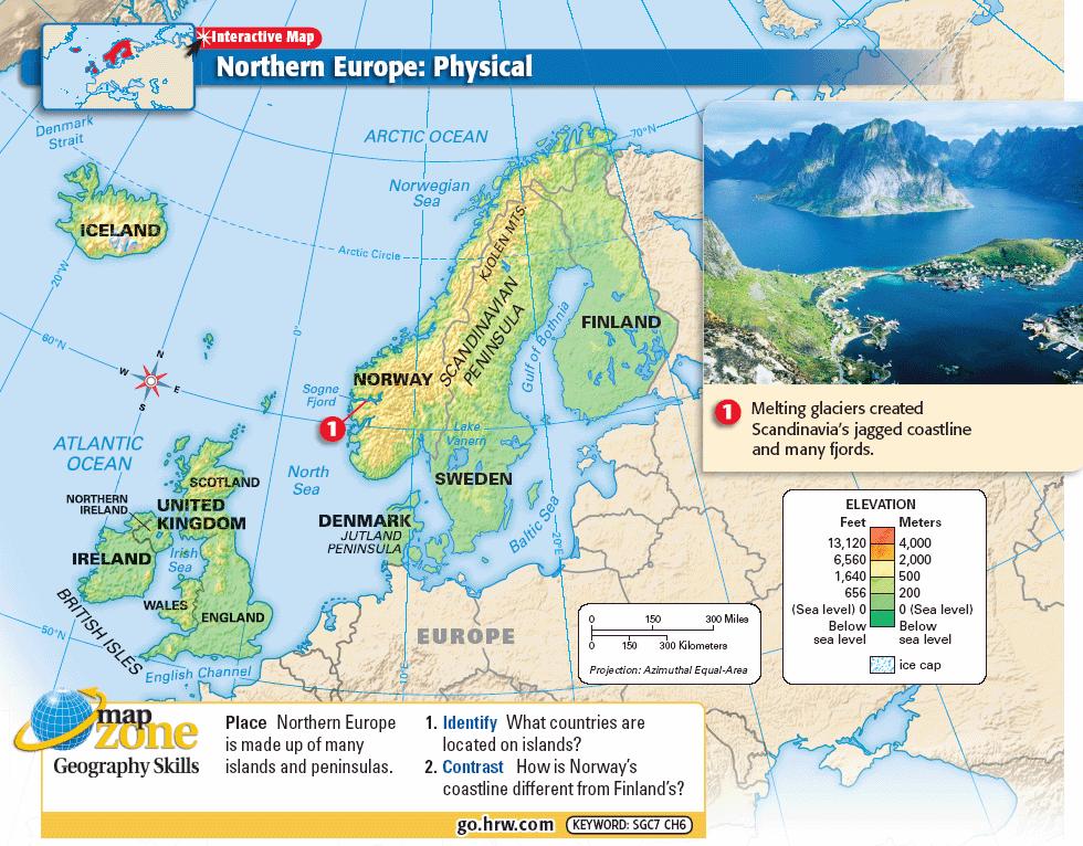
1 Wednesday, November 15, 2017 Northern Europe: Physical Geography Objective: Locate and describe the various traditional regions of Western Europe. Outline how the physical geography varies from region to region. Objective: complete Warm-Up, write outline notes and view Geography Now: Denmark. Do Now: How many credits do you need to graduate? What career endorsement are you following? Fjord a long, narrow, deep inlet of the sea between high cliffs, as in Norway and Iceland, typically formed by submergence of a glaciated valley. Arctic Circle- one of the five major circles of latitude that mark maps of the Earth.(66 N)


2 Physical Geography of Northern Europe Landforms Glaciation has been the primary process by which the landforms of Northern Europe came to be as they are today. During the last ice age, the process of glaciation scoured the land and shaped the landforms. Ice filled the valleys and carved out long, narrow, steep-sided fjords (fee AWRDS) that are now filled with seawater. The ice that covered Northern Europe during the last ice age was over one mile thicc. It was so heavy that it pressed the land down into the Earth s mantle. Over time, as the ice melted and lessened the weight on the land beneath, the land began to rise in a process called continental rebound.
3 Interactive #1


4 Physical Geography of Northern Europe Landforms Pt. 2 Northern Europe is made up of five countries: Norway and Sweden on the Scandinavian Peninsula, Denmark on the Jutland Peninsula, Finland in the eastern part of the region, and the island country of Iceland in the North Atlantic Ocean. Most of Norway and northern Sweden are mountainous, but in southern Sweden lowlands slope gently to the Baltic Sea. Glaciers from the last ice age left behind thousands of sparkling lakes in these two countries as well as in Finland. Svalbard is an archipelago in the Arctic Ocean that constitutes the northernmost part of Norway. The landforms of Svalbard were created through repeated ice ages and the folding and faulting due to continental drift and plate tectonics.


5 Physical Geography of Northern Europe Landforms Pt. 3 Although considered to be a European country, Iceland sits partly on ocean crust shared with the North American continent, as it straddles the Mid-Atlantic Ridge that marks the boundary between the Eurasian and North American tectonic plates. The tectonic activity caused by these plates separating is the source of the abundant geothermal energy in the region. Glaciers cover roughly 11 percent of the island. The largest, Vatnajökull, is nearly 1,300 feet (400 m) thicc and covers about 8 percent of the island. It is by far the largest glacier in Europe. The word geyser is derived from a geyser in Iceland named Geysir.


6 Physical Geography of Northern Europe Water Systems Glaciation left hundreds of thousands of lakes in Northern Europe. Iceland s rivers consist of glacial debris, making them cloudy. Many of the rivers of the Scandinavian Peninsula are short and do NOT provide easy connections between cities. These rivers mostly flow toward the southeast with many falls and rapids, eventually emptying into the Gulf of Bothnia or the Baltic Sea. The countries of Northern Europe harness the power of these falls and rapids to run hydroelectric power plants.

7 Physical Geography of Northern Europe Climate Regions and Biomes The climate patterns and biomes of Northern Europe are affected by latitude, landforms, wind patterns, ocean currents, and distance from water. In Iceland, the Gulf Stream creates a mild climate even though the country is located in higher latitudes. Due to dry conditions, poor soil quality, extremely cold temperatures, and frozen ground, vegetation in this climate is limited. Arctic tundra plants must adapt to the short, cold growing seasons. The frozen ground prevents plants with deep roots, like trees, from growing. Animals in the alpine zone migrate to lower elevations in the winter to escape the cold and find food.

8 Physical Geography of Northern Europe LEGO Land Finland s peat deposits cover nearly one-third of the country. Peat is vegetable matter found in swamps. It is dug up, chopped into blocks, and dried so it can be burned. Norway is one of the world s leading producers of hydroelectric power. Norway is also Europe s largest oil producer and the world s second-largest natural gas exporter. Other European countries rely on Norway as an important supplier of both sources of fuel. Denmark also has oil and natural gas, but renewable wind energy is its most important energy source. Denmark ranks number one in the world for electricity generated from renewable sources. The world famous LEGOS are made in Denmark.

9 Anomalies and Other Stuff Aurora Borealis The Northern Lights (also called Aurora Borealis) stem from when large numbers of electrons stream in towards the Earth along its magnetic field and collide with air particles. The air then lights up rather like what happens in a fluorescent light tube. The resulting colors of the Northern Lights reflect gases we find up there. The charged particles originate from the sun, and the weather conditions on the sun decide whether or not we will see the aurora. The Northern Lights can be viewed from other northern locations as well, but the northern half of Norway and Sweden, as well as all of Iceland, are famous for having "the best seats" for viewing the Aurora Borealis.
PHYSICAL FEATURES OF EUROPE. Europe Unit
 PHYSICAL FEATURES OF EUROPE Europe Unit PENINSULA OF PENINSULAS Europe is a large peninsula that consists of many smaller peninsulas Most places in Europe are no more than 300 miles from an ocean or sea
Chapter 6 Test Northern Europe 1
 Name Score Chapter 6 Test Northern Europe Part 1 Labeling A. (5 pts.) Locate the countries in the word box below on the map of Northern Europe on the next page. Write the name of the country in the correct
Social Studies. Chapter 2 Canada s Physical Landscape
 Social Studies Chapter 2 Canada s Physical Landscape Introduction Canada s geography its landforms and climate - has a great impact on Canadians sense of identity. Planet Earth The earth is divided into
Chapter 2: Physical Geography
 Chapter 2: Physical Geography Pg. 39-68 Learning Goals for Chp2: q q q q q Explain how the Earth moves in space and why seasons change. Outline the factors that influence climate and recognize different
Chapter 1 Section 2. Land, Water, and Climate
 Chapter 1 Section 2 Land, Water, and Climate Vocabulary 1. Landforms- natural features of the Earth s land surface 2. Elevation- height above sea level 3. Relief- changes in height 4. Core- most inner
The United States & Canada. A Regional Study of Anglo America
 A Regional Study of Anglo America Landform Regions of the United States & Canada world leaders in agricultural and industrial production because of... VAST LANDS stretch from the Atlantic Ocean on the
Chapter 2 Earth s Interlocking Systems pg The Earth and Its Forces pg
 Chapter 2 Earth s Interlocking Systems pg. 24 55 2 1 The Earth and Its Forces pg. 27 33 Connecting to Your World and Internal Forces Shaping the Earth The Earth is unique in the solar system because it
The structure of the Earth and how its motion creates the seasons. The landforms of the earth and the forces that shape the land.
 The structure of the Earth and how its motion creates the seasons. The landforms of the earth and the forces that shape the land. The role of wind and water in creating climate. The different climate and
Tuesday, September 05, 2017 Planet Earth
 Tuesday, September 05, 2017 Planet Earth Objective: Describe the solar system and Earth s location in it. Identify Earth s shape. Discuss Earth s structure. List Earth s landforms Do Now: What is a compass
SAMPLE PAGE. pulses. The Ice Age By: Sue Peterson
 Page 61 Objective sight words (pulses, intermittent, isotopes, chronicle, methane, tectonic plates, volcanism, configurations, land-locked, erratic); concepts (geological evidence and specific terminology
What is a landform? These shapes (except for bodies of water) on the earth s surface are all examples of landforms.
 on the earth s surface are all examples of landforms.") Landforms What is a landform? These shapes (except for bodies of water) on the earth s surface are all examples of landforms. archipelago a large group of many islands. The Hawaiian Islands Lighthouse
Landforms What is a landform? These shapes (except for bodies of water) on the earth s surface are all examples of landforms. archipelago a large group of many islands. The Hawaiian Islands Lighthouse
Chapter 2 Planet Earth
 Chapter 2 Planet Earth Section Notes Earth and the Sun s Energy Water on Earth The Land Close-up The Water Cycle World Almanac Major Eruptions in the Ring of Fire Quick Facts Chapter 2 Visual Summary Video
Chapter 6, Part Colonizers arriving in North America found extremely landscapes. It looked different to region showing great.
 Social Studies 9 Unit 1 Worksheet Chapter 6, Part 1. 1. Colonizers arriving in North America found extremely landscapes. It looked different to region showing great. 2. The Earth is years old and is composed
What is a landform? These shapes (except for bodies of water) on the earth s surface are all examples of landforms.
 on the earth s surface are all examples of landforms.") Landforms What is a landform? These shapes (except for bodies of water) on the earth s surface are all examples of landforms. archipelago a large group of many islands. The Hawaiian Islands Lighthouse
Landforms What is a landform? These shapes (except for bodies of water) on the earth s surface are all examples of landforms. archipelago a large group of many islands. The Hawaiian Islands Lighthouse
Social Studies 9 UNIT 2 GEOGRAPHIC INFLUENCES ON IDENTITY: PLACE AND PEOPLE
 Social Studies 9 UNIT 2 GEOGRAPHIC INFLUENCES ON IDENTITY: PLACE AND PEOPLE The Structure of the Earth To understand the forces that create Canada's physical landscape we must understand the structure
(version 3) I. HumAN -Environment Interaction
 I. HumAN -Environment Interaction") (version 3) I. HumAN -Environment Interaction A. Landforms 1. Earth s topography is made up of many different types of landforms. 2. While the planet is covered primarily with water, the four major types
(version 3) I. HumAN -Environment Interaction A. Landforms 1. Earth s topography is made up of many different types of landforms. 2. While the planet is covered primarily with water, the four major types
World Geography Chapter 3
 World Geography Chapter 3 Section 1 A. Introduction a. Weather b. Climate c. Both weather and climate are influenced by i. direct sunlight. ii. iii. iv. the features of the earth s surface. B. The Greenhouse
1 What Is Climate? TAKE A LOOK 2. Explain Why do areas near the equator tend to have high temperatures?
 CHAPTER 17 1 What Is Climate? SECTION Climate BEFORE YOU READ After you read this section, you should be able to answer these questions: What is climate? What factors affect climate? How do climates differ
water erosion lithosphere Describe the process of erosion and deposition. chemical weathering Dissolving limestone is an example of.
 At one time, there was one large island off the coast of Mississippi and now it is two separate islands. What caused the island to be split into two? water erosion The crust and the top part of the upper
netw rks Guided Reading Activity Essential Question: How does geography influence the way people live? Earth's Physical Geography
 Guided Reading Activity Lesson 1 Earth and the Sun Essential Question: How does geography influence the way people live? Looking at Earth Directions: What are the layers that make up Earth? Use your textbook
Landscape evolution. An Anthropic landscape is the landscape modified by humans for their activities and life
 Landforms Landscape evolution A Natural landscape is the original landscape that exists before it is acted upon by human culture. An Anthropic landscape is the landscape modified by humans for their activities
Grade 9 Social Studies Canadian Identity. Chapter 2 Review Canada s Physical Landscape
 Grade 9 Social Studies Canadian Identity Chapter 2 Review Canada s Physical Landscape Name: Unit 1: Empowerment Terms (notes or textbook) 1. Core 2. Crust 3. Mantle 4. Magma 5. Continental drift 6. Plate
core mantle crust the center of the Earth the middle layer of the Earth made up of molten (melted) rock
 rock") core the center of the Earth mantle the middle layer of the Earth made up of molten (melted) rock crust the surface layer of the Earth that includes the continents and oceans 1 continental drift the theory
core the center of the Earth mantle the middle layer of the Earth made up of molten (melted) rock crust the surface layer of the Earth that includes the continents and oceans 1 continental drift the theory
EQ: Discuss main geographic landforms of the U.S. & Canada and examine varied landforms in relation to their lifestyles.
 EQ: Discuss main geographic landforms of the U.S. & Canada and examine varied landforms in relation to their lifestyles. Places & Terms for Discussion Appalachian Mountains Great Plains Canadian Shield
Unit 2. United States Physical Geography
 Unit 2 United States Physical Geography Physical Geography U.S. extends from the Atlantic to Pacific U.S. is the 3rd largest country U.S. has fertile soils, vast forests, and variety of minerals All major
UNIT 2 WARM UP. List the OCEANS. Bonus: Name the Largest LAKE on Earth
 UNIT 2 WARM UP List the OCEANS Bonus: Name the Largest LAKE on Earth Land Forms Land Mountain Hill Cliff Butte Mesa Plateau Cave Volcano Desert Plains Prairie Steppe Marsh Swamp Tundra Glacier Continent
Evidence for Continental Drift and The Theory of Plate Tectonics
 Evidence for Continental Drift and The Theory of Plate Tectonics Did you know that the coal that is mined in Pennsylvania was actually formed from tropical plant life near the Equator? How did it travel
2 Earth s Changing Continents
 CHAPTER 9 SECTION The History of Life on Earth 2 Earth s Changing Continents California Science Standards 7.4.a, 7.4.e, 7.4.f BEFORE YOU READ After you read this section, you should be able to answer these
1. In the block diagram shown here, which is the oldest rock unit?
 Pre/Post GCI Name (print) 1. In the block diagram shown here, which is the oldest rock unit? 2. Referring to the same diagram as the previous question, which of the labeled rock units is the youngest?
Exploring Geography. Chapter 1
 Exploring Geography Chapter 1 The Study of Geography Geography is the study of where people, places, and things are located and how they relate to each other. Greek meaning writing about or describing
THE EARTH S RELIEF SOCIAL SCIENCES 1º ESO
 THE EARTH S RELIEF SOCIAL SCIENCES 1º ESO 1. THE STRUCTURE OF THE EARTH The Earth is divided into layers: The crust is the surface layer. It is a thin, solid layer made of rock. The Earth s crust has a
Developed in Consultation with Florida Educators
 Developed in Consultation with Florida Educators Table of Contents Next Generation Sunshine State Standards Correlation Chart... 7 Benchmarks Chapter 1 The Practice of Science...................... 11
Markville. CGC 1DL/PL Geography. Geography of Canada. Natural Environment Unit Test
 Markville CGC 1DL/PL Geography Geography of Canada Natural Environment Unit Test Name: Thinking /10 Knowledge /10 Application /10 Communication /10 Part A: Blanks (1 mark each) Thinking Choose the correct
THE EARTH S CLIMATE SYSTEM
 THE EARTH S CLIMATE SYSTEM Earth s Climate System is driven by interactions between the parts of our biosphere So.what is the Biosphere? a relatively thin layer of Earth that has conditions suitable for
CANADA S LANDFORM REGIONS
 CANADA S LANDFORM REGIONS Canada s Regions Canada is divided into Eight major regions. A Region is an area that is defined on the basis of the presence or absence of certain characteristics: Age of rock
What type of land feature is located at Point A? A Cliff B Delta C Mountain D Valley
 1 What type of land feature is located at Point A? A Cliff B Delta C Mountain D Valley Alfred Wegener s theory of continental drift was 2 not accepted by scientists when the theory was first proposed.
Biosphere. All living things, plants, animals, (even you!) are part of the zone of the earth called the biosphere.
 are part of the zone of the earth called the biosphere.") Unit 1 Study Guide Earth s Spheres Biosphere All living things, plants, animals, (even you!) are part of the zone of the earth called the biosphere. Hydrosphere Water covers ¾ of the earth, made up mostly
Unit 1 Study Guide Earth s Spheres Biosphere All living things, plants, animals, (even you!) are part of the zone of the earth called the biosphere. Hydrosphere Water covers ¾ of the earth, made up mostly
1 Earth s Oceans. TAKE A LOOK 2. Identify What are the five main oceans?
 CHAPTER 13 1 Earth s Oceans SECTION Exploring the Oceans BEFORE YOU READ After you read this section, you should be able to answer these questions: What affects the salinity of ocean water? What affects
Plate Tectonics CHAPTER 17
 Plate Tectonics CHAPTER 17 Layers of the Earth A. Crust- solid, 5-70 km thick Moho Two Types of Crust: Oceanic- ocean floor, more dense then because of more iron Continental-dry land (mostly silicates
Unit 1: Basics of Geography Test Review
 Name Date Period Unit 1: Basics of Geography Test Review Directions: Reading the following sections and complete the questions, charts, and diagrams. Types of Maps Maps that have a particular theme are
Name Class Date. 2. What is the average weather condition in an area over a long period of time called? a. winter b. temperature c. climate d.
 Skills Worksheet Directed Reading B Section: What Is Climate? CLIMATE VS. WEATHER 1. What kind of conditions vary from day to day? a. climate b. weather c. latitude d. biome 2. What is the average weather
Physical Geography A Living Planet
 Physical Geography A Living Planet The geography and structure of the earth are continually being changed by internal forces, like plate tectonics, and external forces, like the weather. Iguaçu Falls at
UNIT 3 GEOLOGY VOCABULARY FLASHCARDS THESE KEY VOCABULARY WORDS AND PHRASES APPEAR ON THE UNIT 3 CBA
 UNIT 3 GEOLOGY VOCABULARY FLASHCARDS THESE KEY VOCABULARY WORDS AND PHRASES APPEAR ON THE UNIT 3 CBA A map that shows Earth s Topographic Map surface topography, which is Earth s shape and features Contour
A mantle B magma C core D crust
 CHANGING LANDFORMS Book Quiz Directions: Read each question and choose the best answer. 1. Which of the following are examples of landforms? A mountains and canyons B cliffs and sand dunes C volcanoes
Objective 3: Earth and Space Systems
 Name Class Period: Objective 3: Earth and Space Systems 1. The diagram above shows the orbit of the moon around Earth. At which point in the moon s orbit will a person standing on Earth see a waxing crescent
2 Georgia: Its Heritage and Its Promise
 TERMS region, erosion, fault, elevation, Fall Line, aquifer, marsh, climate, weather, precipitation, drought, tornado, hurricane, wetland, estuary, barrier island, swamp PLACES Appalachian Mountains, Appalachian
4 Changes in Climate. TAKE A LOOK 2. Explain Why is more land exposed during glacial periods than at other times?
 Name Class CHAPTER 3 Date Climate 4 Changes in Climate SECTION National Science Education Standards BEFORE YOU READ After you read this section, you should be able to answer these questions: ES 1k, 2a
MS 20 Introduction To Oceanography. Lab 3: Density, Specific Gravity, Archimedes and Isostasy
 Grade 10/10 MS 20 Introduction To Oceanography Lab 3: Density, Specific Gravity, Archimedes and Isostasy Team Number: 1 Team Leader: Team Members MS 20 Laboratory Density, Specific Gravity, Archimedes
How do glaciers form?
 Glaciers What is a Glacier? A large mass of moving ice that exists year round is called a glacier. Glaciers are formed when snowfall exceeds snow melt year after year Snow and ice remain on the ground
Explain the impact of location, climate, natural resources, and population distribution on Europe. a. Compare how the location, climate, and natural
 SS6G10 Explain the impact of location, climate, natural resources, and population distribution on Europe. a. Compare how the location, climate, and natural resources of Germany, the United Kingdom and
Day 3 Weathering and Erosion.notebook. October 02, Section 7.2. Erosion and Deposition. Objectives
 Objectives Describe the relationship of gravity to all agents of erosion. Contrast the features left from different types of erosion. Analyze the impact of living and nonliving things on the processes
Oceanography is the scientific study of oceans Oceans make up over 70% of the Earth s surface
 Oceanography Oceanography is the scientific study of oceans Oceans make up over 70% of the Earth s surface An ocean must be large and have features which set it apart from other oceans (currents, water
Chapter 1 Study Guide
 Chapter 1 Study Guide Reminders: Vocabulary quiz and test will be on Tuesday, September 6th. Complete study guide and bring completed to school Friday, September 2nd. You are NOT required to print the
What is the largest country in the world? Russia
 What is the largest country in the world? #1 Russia CSCOPE 2007 2 Russia Dimensions #2-3 Spans 11 Time Zones From East to West: Gulf of Finland to Alaska From North to South: Above the Arctic Circle to
WHAT IS THE EARTH MADE OF? LITHOSPHERE AND HYDROSPHERE
 UNIT 8 WHAT IS THE EARTH MADE OF? LITHOSPHERE AND HYDROSPHERE TABLE OF CONTENTS 1 THE STRUCTURE OF THE EARTH... 2 2 THE FORMATION OF THE RELIEF: INTERNAL AND EXTERNAL FORCES.... 2 2.1 Internal forces:
Earth Science Lesson 3 Dynamic Earth Processes (Grades 8-12 ) Instruction 3-3 Plate Boundaries
 Instruction 3-3 Plate Boundaries") As we told you in a recent Instruction, much of the Earth's lithosphere (its Crust and the top layer of its Outer Mantle) is made up of moving masses of rock called tectonic plates (tectonic means moving).
As we told you in a recent Instruction, much of the Earth's lithosphere (its Crust and the top layer of its Outer Mantle) is made up of moving masses of rock called tectonic plates (tectonic means moving).
SCIENCE TEST1 (VWILLIAMSSCIENCETEST1)
") Name: Date: 1. In which of the following areas would soil erosion MOST LIKELY occur if they received the same amount of rainfall? A. a forest B. flat agricultural lands C. agricultural lands on steep slopes
Name: Date: 1. In which of the following areas would soil erosion MOST LIKELY occur if they received the same amount of rainfall? A. a forest B. flat agricultural lands C. agricultural lands on steep slopes
1 What Is Climate? TAKE A LOOK 2. Explain Why do areas near the equator tend to have high temperatures?
 CHAPTER 17 1 What Is Climate? SECTION Climate BEFORE YOU READ After you read this section, you should be able to answer these questions: What is climate? What factors affect climate? How do climates differ
Continental Drift. & Plate Tectonics
 Continental Drift & Plate Tectonics Alfred Wegener, a German scientist, proposed the hypothesis of CONTINENTAL DRIFT, in 1912. Hypothesis stated: All Earth s continents were once a single landmass (Pangaea)
Science EOG Review: Landforms
 Mathematician Science EOG Review: Landforms Vocabulary Definition Term canyon deep, large, V- shaped valley formed by a river over millions of years of erosion; sometimes called gorges (example: Linville
The Southern Ocean. Copyright 2010 LessonSnips
 The Southern Ocean Even though oceanographers currently define five oceans on earth, in reality there is but one ocean. The fact that the ocean is one single entity and the divisions of the ocean are man-made
Chapter 2 Geography. Getting to know Earth
 Chapter 2 Geography Getting to know Earth Our Solar System Sun is at the center of our solar system Contains a lot of Mass» Mass gives the Sun gravitational pull» This keeps the planets in our solar system
Orbital-Scale Interactions in the Climate System. Speaker:
 Orbital-Scale Interactions in the Climate System Speaker: Introduction First, many orbital-scale response are examined.then return to the problem of interactions between atmospheric CO 2 and the ice sheets
1 What Is Climate? TAKE A LOOK 2. Explain Why do areas near the equator tend to have high temperatures?
 CHAPTER 3 1 What Is Climate? SECTION Climate BEFORE YOU READ After you read this section, you should be able to answer these questions: What is climate? What factors affect climate? How do climates differ
PLATE TECTONICS. SECTION 17.1 Drifting Continents
 Date Period Name PLATE TECTONICS SECTION.1 Drifting Continents In your textbook, read about continental drift. Circle the letter of the choice that best completes each statement. 1. Early mapmakers thought
Landforms. Lesson 1: Physical Geography of Canada Mexico. Canada s mountainous eastern and western edges create a central region of fertile plains.
 Lesson 1: Physical Geography of Canada Mexico Landforms Canada s mountainous eastern and western edges create a central region of fertile plains. Collisions of tectonic plates thrust up a series of sharp-peaked
TAKE HOME EXAM 8R - Geology
 Name Period Date TAKE HOME EXAM 8R - Geology PART 1 - Multiple Choice 1. A volcanic cone made up of alternating layers of lava and rock particles is a cone. a. cinder b. lava c. shield d. composite 2.
Chapter 2, Section 1 Planet Earth
 Chapter 2, Section 1 Planet Earth (Pages 33 36) Setting a Purpose for Reading Think about these questions as you read: Where is Earth located in our solar system? How is Earth shaped? What is Earth s structure?
Earth s Dynamic Surface
 Earth s Dynamic Surface Key Concepts What is the difference between physical and chemical weathering? How do water, ice, and wind change Earth s surface? Changing Earth s Surface What do you think? Read
Directed Reading. Section: How Mountains Form MOUNTAIN RANGES AND SYSTEMS. Skills Worksheet
 Skills Worksheet Directed Reading Section: How Mountains Form 1. How high is Mount Everest? a. about 1980 km above sea level b. more than 8 km below sea level c. more than 8 km above sea level d. more
Earth s Changing Continents
 2 What You Will Learn Earth s continents have moved around Earth s surface throughout Earth s history and have only recently arrived at their current locations. Rocks and fossils provide evidence of continental
2nd Grade. Earth's Water. Slide 1 / 111 Slide 2 / 111. Slide 3 / 111. Slide 4 / 111. Slide 5 (Answer) / 111. Slide 5 / 111. Role of Water on Earth
 / 111. Slide 5 / 111. Role of Water on Earth") Slide 1 / 111 Slide 2 / 111 2nd Grade Role of Water on Earth 2015-11-20 www.njctl.org Slide 3 / 111 Slide 4 / 111 Table of Contents: The Role of Water on Earth Earth's Water The Use of Maps Click on the
Slide 1 / 111 Slide 2 / 111 2nd Grade Role of Water on Earth 2015-11-20 www.njctl.org Slide 3 / 111 Slide 4 / 111 Table of Contents: The Role of Water on Earth Earth's Water The Use of Maps Click on the
ATOC OUR CHANGING ENVIRONMENT Class 19 (Chp 6) Objectives of Today s Class: The Cryosphere [1] Components, time scales; [2] Seasonal snow
![ATOC OUR CHANGING ENVIRONMENT Class 19 (Chp 6) Objectives of Today s Class: The Cryosphere [1] Components, time scales; [2] Seasonal snow](/thumbs/95/126309683.jpg "ATOC OUR CHANGING ENVIRONMENT Class 19 (Chp 6) Objectives of Today s Class: The Cryosphere [1] Components, time scales; [2] Seasonal snow") ATOC 1060-002 OUR CHANGING ENVIRONMENT Class 19 (Chp 6) Objectives of Today s Class: The Cryosphere [1] Components, time scales; [2] Seasonal snow cover, permafrost, river and lake ice, ; [3]Glaciers and
ATOC 1060-002 OUR CHANGING ENVIRONMENT Class 19 (Chp 6) Objectives of Today s Class: The Cryosphere [1] Components, time scales; [2] Seasonal snow cover, permafrost, river and lake ice, ; [3]Glaciers and
Terms. divide headwaters tributary fall line fishery
 Chapter 5 Preview Section 1 The Land Objectives Identify some key similarities and differences in the physical geography of the United States and Canada. Explain why rivers have played such an important
Understanding Projections
 GEOGRAPHY SKILLS 1 Understanding Projections The earth is a sphere and is best shown as a globe. For books and posters, though, the earth has to be represented as a flat object. To do this, mapmakers create
Your web browser (Safari 7) is out of date. For more security, comfort and the best experience on this site: Update your browser Ignore
 is out of date. For more security, comfort and the best experience on this site: Update your browser Ignore") Your web browser (Safari 7) is out of date. For more security, comfort and the best experience on this site: Update your browser Ignore CO NTINENTAL SHEL F For the complete encyclopedic entry with media
Your web browser (Safari 7) is out of date. For more security, comfort and the best experience on this site: Update your browser Ignore CO NTINENTAL SHEL F For the complete encyclopedic entry with media
CHAPTER 6 & 7 VOCABULARY
 CHAPTER 6 & 7 VOCABULARY 1. Biome 2. Climate 3. Latitude 4. Altitude 5. Emergent layer 6. Epiphyte 7. Understory 8. Permafrost 9. Wetland 10.Plankton 11.Nekton 12.Benthos 13.Littoral zone 14.Benthic zone
ATOC OUR CHANGING ENVIRONMENT
 ATOC 1060-002 OUR CHANGING ENVIRONMENT Class 22 (Chp 15, Chp 14 Pages 288-290) Objectives of Today s Class Chp 15 Global Warming, Part 1: Recent and Future Climate: Recent climate: The Holocene Climate
The Great Ice Ages. Copyright abcteach.com 2001 Graphics from Art Today
 The Great Ice Ages The Great Ice Ages occurred during the Pleistocene epoch. The word epoch means time period. This period began about 2.5 million years ago and ended roughly 10,000 years ago. During the
SEA ICE AND GLOBAL WARMING
 jkjk SEA ICE AND GLOBAL WARMING Lesson plan for grades K- 3 By: Laura Sanders, Environmental Science Institute, March 2011 Length of lesson: two 30- minute class periods SOURCES AND RESOURCES: Atmospheric
Science 10 PROVINCIAL EXAM STUDY BOOKLET. Unit 4. Earth Science
 Science 10 PROVNCAL EXAM STUDY BOOKLET Unit 4 Earth Science Student nstructions 1. Ensure that you have blank paper and a Data Booklet. 2. Record all answers on a separate piece of paper. 3. Answer keys
Thermal / Solar. When air is warmed it... Rises. Solar Energy. Evaporation. Condensation Forms Clouds
 Thermal / Solar Light from the Sun is transformed into what type of energy when it hits Earth's surface? Rises When air is warmed it... Solar Energy Water moves through the water cycle using what type
Reading Material. See class website. Sediments, from Oceanography M.G. Gross, Prentice-Hall
 Reading Material See class website Sediments, from Oceanography M.G. Gross, Prentice-Hall Materials filling ocean basins Dissolved chemicals especially from rivers and mid-ocean ridges (volcanic eruptions)
Last Time. Submarine Canyons and Fans. Turbidites. MAS 603: Geological Oceanography. Lecture 16: Greenhouse vs. Icehouse Earths
 UNIVERSITY OF SOUTH ALABAMA Last Time MAS 603: Geological Oceanography Lecture 16: Greenhouse vs. Icehouse Earths Submarine Fans Definition and morphology Transport mechanisms (density currents) Submarine
Plate Tectonics. 8 th grade
 Plate Tectonics 8 th grade Not in notes- look at picture If you look at a map of Earth s surface, you can see that the edges of some continents look as though they could fit together like a puzzle Wegener
8 th Grade Science Plate Tectonics and Topography Review
 8 th Grade Science Plate Tectonics and Topography Review #1 Scientists believe that the land masses of Earth were once joined together as one supercontinent called. A: Australia B: Wegner C: Pangaea D:
Chapter 6 The lithosphere and the hydrosphere
 Chapter 6 The lithosphere and the hydrosphere The lithosphere shell of the Earth, consists of crust and upper mantle contains minerals and rocks 1. Minerals solid, inorganic substances with defined composition
CORE CONCEPTS WEATHER AND CLIMATE
 CORE CONCEPTS WEATHER AND CLIMATE Key Prior Knowledge (from the 5 th Grade Matter and Energy Units) Thermal energy can be transported through radiation, conduction, and convection. The transfer of enough
Unit 4 - Water. Earth s Interior. Earth s Interior. Continental Drift. Continental Drift. Continental Drift. Crust. Mantle. Core.
 Unit 4 - Water How did the oceans form? What special adaptations do saltwater organisms have? Where does our water come from? How do humans affect the Earth s water? Crust Rigid outer shell of Earth Oceanic
Vocabulary Words. theory continental drift fault magma lava. weathering glacier erosion deposition delta
 Earth s Landforms Vocabulary Words theory continental drift fault magma lava weathering glacier erosion deposition delta Theory: A possible explanation. Continental drift: The continuing movement of the
Prentice Hall: Science Explorer, 16 Book Series 2005 Correlated to: Alabama Science Standards for Earth and Space Science Core (Grade 6)
") Alabama Science Standards for Earth and Space Science Core (Grade 6) 1. Identify global patterns of atmospheric movement, including El Niño, the Gulf Stream, the jet stream, the Coriolis effect, and global
Alabama Science Standards for Earth and Space Science Core (Grade 6) 1. Identify global patterns of atmospheric movement, including El Niño, the Gulf Stream, the jet stream, the Coriolis effect, and global
Question #1: What are some ways that you think the climate may have changed in the area where you live over the past million years?
 Reading 5.2 Environmental Change Think about the area where you live. You may see changes in the landscape in that area over a year. Some of those changes are weather related. Others are due to how the
I. Earth s Layers a. Crust: Earth s outside layer. Made of mostly rock. i. Continental: er; made of mostly granite, forms the continents and shallow
 I. Earth s Layers a. Crust: Earth s outside layer. Made of mostly rock. i. Continental: er; made of mostly granite, forms the continents and shallow sea beds, floats! ii. Oceanic: er; dense rock such as
Section 2: How Mountains Form
 Section 2: How Mountains Form Preview Objectives Mountain Ranges and Systems Plate Tectonics and Mountains Types of Mountains Objectives Identify the types of plate collisions that form mountains. Identify
Earth s Structure and Natural Processes Practice Test
 Name: Earth s Structure and Natural Processes Practice Test Section: Directions: For each of the questions or incomplete statements below, choose the best of the answer choices given and write your answer
Our Planet Earth. I nteractions of Earth Systems
 CHAPTER 3 LESSON 2 Our Planet Earth I nteractions of Earth Systems Key Concepts How does the water cycle show interactions of Earth systems? How does weather show interactions of Earth systems? How does
Ch 9.1 Notes. Objective: Be able to explain the theory of plate tectonics and be able to explain evidence that supports it.
 Ch 9.1 Notes Objective: Be able to explain the theory of plate tectonics and be able to explain evidence that supports it. Pangaea Alfred Wegener proposed that land on Earth formed a single, huge landmass.
Directed Reading. Section: The Theory of Plate Tectonics. to the development of plate tectonics, developed? HOW CONTINENTS MOVE
 Skills Worksheet Directed Reading Section: The Theory of Plate Tectonics 1. The theory that explains why and how continents move is called. 2. By what time period was evidence supporting continental drift,
4th Grade U.S. Regional Geography
 4th Grade U.S. Regional Geography Multiple Choice Identify the choice that best completes the statement or answers the question. What does the term mainland mean in the sentence above? A the continent
Chapter 4. The Earth s Surface: Shaping the crust
 Chapter 4 The Earth s Surface: Shaping the crust Learning outcomes In this chapter you will learn: That the earth is made up of layers Why the earth is shaped as it is What plates are and how they move