DAMAGE SCENARIO UNDER HYPOTHETICAL RECURRENCE OF 1934 EARTHQUAKE INTENSITIES IN VARIOUS DISTRICTS IN BIHAR
|
|
|
- Rudolph Doyle
- 6 years ago
- Views:
Transcription
1
2 DAMAGE SCENARIO UNDER HYPOTHETICAL RECURRENCE OF 1934 EARTHQUAKE INTENSITIES IN VARIOUS DISTRICTS IN BIHAR Authored by: Dr. Anand S. Arya, FNA, FNAE Professor Emeritus, Deptt. of Earthquake Engg., I.I.T. Roorkee Former National Seismic Advisor, MHA, New Delhi Padmashree awarded by the President, 2002 Member BSDMA, Bihar Assisted by: Barun Kant Mishra PS to Member BSDMA, Bihar i

3 Vice Chairman Bihar State Disaster Management Authority Government of Bihar FOREWORD Earthquake is a natural hazard that can neither be prevented nor predicted. It is generated by the process going on inside the earth, resulting in the movement of tectonic plates. It has been seen that wherever earthquake occurs, it occurs again and again. It is quite probable that an earthquake having the intensity similar to 1934 Bihar-Nepal earthquake may replicate again. Given the extent of urbanization and the pattern of development in the last several decades, the repeat of 1934 in future will be catastrophic in view of the increased population and the vulnerable assets. Prof A.S.Arya, member, BSDMA has carried out a detailed analysis keeping in view the possible damage scenario under a hypothetical event, having intensity similar to 1934 earthquake. Census of India 2011 has been used for the population and housing data, while the revised seismic zoning map of India is the basis for the maximum possible earthquake intensity in various blocks of Bihar. Probable loss of human lives, probable number of housing, which will need reconstruction, or retrofitting has been computed for various districts and the blocks within the districts. The following grim picture of losses has emerged for the state of Bihar. Loss of human lives may be to the extent of 2,22,337, if earthquake occurs at night; but 72,766 if earthquake occurs during daytime. About 20 % of the total housing in Bihar will need re-construction whereas; about 45 % of the total housing in Bihar will need repairing and retrofitting. ii
4 The projected damage scenario highlights the absolute seriousness of the situation given the present building stock and demands that all new construction in Bihar, without any exception, must be earthquake resistant and the existing critical and large occupancy buildings need to be surveyed and retrofitted, if required. I must complement Prof Arya for this pioneering work and also appreciate the work done by Mr Barun Kant Mishra in carrying out this study. I am sure this exercise will go a long way in creating awareness and education in the public about the gravity of emerging vulnerability in the state due to seismic hazard. Anil Kumar Sinha, IAS (retd.) Vice Chairman, BSDMA, Bihar iii

5 Member Bihar State Disaster Management Authority Government of Bihar PREFACE During the past 180 years, Bihar has faced devastating earthquakes in 1833 and 1934, followed by a less damaging earthquake in The epicenter of 1833 earthquake was in central-east Nepal, which caused widespread damages at Monghyr, Muzaffarpur and other places in Bihar. Earthquake of magnitude 8.4 had occurred in 1934, having epicenter close to Bihar border in eastern Nepal, which devastated vast areas of North Bihar from East Champaran to Araria; severe damages were reported from Patna, Barh and Jamalpur also; Munghyr was completely ruined. In 1988, Earthquake of magnitude 6.6, epicenter at South-East Nepal, affected the districts of Darbhanga, Madhubani, Saharsa and Munger. The object of this study is to estimate the probable damages and loss of lives that may occur in Bihar, if the 1934 earthquake intensity repeats. Therefore, hypothetical recurrence of postulated earthquake intensities in various districts and blocks of Bihar, have been analyzed based on Housing and population data of Census of India For computation of probable building damage in a given area, a relation has been established with building types and seismic intensities. The building types based on wall material of 2011 Census have been correlated to the building types defined under MSK 1964 intensities, such as Type-A (Un-burnt brick houses, clay houses), Type-B (ordinary burnt brick buildings), Type-C1 (wood), Type-C2 (concrete) and Type-X (grass / plastic / bamboo / polythene / G.I. / asbestos sheets). Seismic intensity zones are V, IV and III as per the Seismic zoning map of India (IS: ). Damage grades are adopted from G1 (slight damage) to G5 (total damage). Numerical values have been assigned to different damage grades in different Seismic intensity zones. Number of housing under damage grade of G5, G4, G3 and G2 have been computed for various districts and blocks, placed in different Seismic zones. iv
6 Risk of loss of human lives is based on the damage grade, the average population per house, the time of occurrence of earthquake, the type of construction and type of the roof of the collapsed houses. Losses of human lives are considered under damage grades of Collapse and Destruction (G5 and G4) and under grades G3 and G2 assumed nil. Type of roof was considered R1(Light weight pitched roofs), R2 (Pitched roofs with heavy weight covering) and R3 (Heavy flat roofs consisting of wood joists carrying bricks and earth fill, stone slabs, RB or RC roof slabs). A life loss Reduction Factor for a district is based on Light roof housing type R1 and R2. For occurrence of Earthquake at a favorable time, life loss reduction factor for clear weather and daytime has also been considered. During the postulated earthquake, a large number of losses of human lives are noticed and a huge number of re-construction and repair of houses will be required. Therefore, to reduce the trauma during post disaster, it is the time to determine that whatever is built now, must be earthquake resistant! And the most critical buildings needed for human survival must be surveyed and retrofitted. Assistance provided by Shri. Barun Kant Mishra, Private Secretary to the Member, BSDMA throughout this study is gratefully acknowledged. Dr. Anand S. Arya, Member, BSDMA, Bihar v
7 Subjects CONTENTS Page 1. INTRODUCTION 1 2. THREE DAMAGING EARTHQUAKES IN THE TERRITORY OF BIHAR Damage Scenario observed in 1833 Bihar-Nepal earthquake Damage Scenario observed in 1934 Bihar-Nepal earthquake The 1988 Bihar-Nepal Earthquake 3 3. SEISMIC ZONING MAP OF BIHAR 4 4. HOUSING DATA REQUIRED FOR WORKING OUT DAMAGE SCENARIOS 5 a) Walling material 6 b) Roofing material 6 5. RELATIONSHIP OF HOUSE TYPES WITH EARTHQUAKE DAMAGING INTENSITIES Walling Material Classification Roofing Material 7 6. THE DAMAGING EARTHQUAKE INTENSITIES Damage grades Probable Damages Stated in MSK Intensities VI to IX Definition of terms Most, Many and a Few Relationship of Building damages with building types and seismic intensity 8 7. COMPUTATION OF PROBABLE BUILDING DAMAGE IN A GIVEN AREA Number of Housing of different Types Number of housing under different damage grades RISK OF LOSS OF HUMAN LIVES 12 (i) The time of occurrence of the earthquake 12 (ii) Type of Construction 12 (iii) Type of Roof of the collapsed house 13 (iv) Loss of Lives in 1934 Earthquake projected to the year ESTIMATION FOR LOSS OF LIVES ESTIMATION OF RECONSTRUCTION & REPAIRING CONCLUSION 18 Annexure A : Understanding Census Housing 19 Report-1. Damage Scenario under hypothetical Earthquake in Bihar 21 Report-2. Computation of R and F for each district of Bihar 37 Report-3. Computation for Light Roof Reduction factor 38 vi
8 DAMAGE SCENARIO UNDER HYPOTHETICAL RECURRENCES OF 1934 EARTHQUAKE INTENSITIES IN VARIOUS DISTRICTS IN BIHAR 1. INTRODUCTION The aim of this document is to look at the damage scenarios in various Blocks and s of Bihar during a hypothetical earthquake having intensity similar to 1934 Bihar-Nepal earthquake if it recurs in the years soon following the Census year The 1934 Earthquake had serious impact on the population of Bihar. Incidentally, seismic zoning map of Bihar closely follows the intensity Iso-seismals of earthquake of See Fig. 1 and Fig. 3 for comparison. Housing and population data required for working out Damage Scenarios is based on 2011 Census of India. Building types stipulated in 2011 Census have been correlated to the building types defined under MSK intensities so as to achieve the number of Census houses having various Damage Grades in different Seismic Zones. Human lives are lost under damage grades of Collapse and Destruction (G5 and G4). In the post earthquake situation, buildings under damage grades of Collapse and Destruction will need reconstruction while buildings under damage grades of moderate damage G2 and heavy damage G3 may be repaired and retrofitted. 2. THREE DAMAGING EARTHQUAKES IN THE TERRITORY OF BIHAR 2.1 Damage Scenario observed in 1833 Bihar-Nepal earthquake This is mentioned as a violent earthquake in Mallet s Earthquake Catalogue of the British Association. It had shaken the eastern India and Nepal between 5.30 to 8.00 PM on Aug. 26, The epicenter of the earthquake is stated as about 27½ o N 86.5 o E and Magnitude 7 ½ to 8 in the earthquake catalogue prepared by the India Meteorology Department, Govt. of India. It will thus be at about 100 km north of Indian border, inside Nepal. Widespread damage occurred in Nepal killing 414 persons. In India water was thrown out of tanks 1.2 m deep at Muzaffarpur, a Chasm of considerable size was formed in the earth at Chapra and many houses were destroyed and damaged at Monghyr, Rangpur, Muzaffarpur and other places. No loss of life was reported in India. 2.2 Damage Scenario observed in 1934 Bihar-Nepal earthquake This earthquake of Magnitude estimated between 8.3 and 8.6 (assigned 8.4) had occurred on 15th January 1934 with origin time and location assigned as 14 h 13 min 25 sec Indian Standard time at 26.6 o N Lat o E long. It is one of the few most violent earthquakes experienced in India and Nepal so far wherein 7153 lives were lost in India and about 8519 in Nepal. In this earthquake the towns of Monghyr in India and Bhatgaon in Nepal were completely in ruins, so were large parts of the cities of Motihari, Muzaffarpur and Darbhanga in India and, Patan and Kathmandu in Nepal, not mentioning the numerous villages razed to the ground in both countries. Large tracts in the districts of East Champaran, Sitamarhi, Madhubani, Saharsa and Purnia in a length of about 300 km and average width of about 50 km slumped due to liquefaction of sands and at many places sand fountains and sand-boils had occurred on a - 1 -

9 large scale. In Sitamarhi, Madhubani and Purnia houses had greatly tilted and sank into the ground. In Purnia 95 percent houses became uninhabitable including 50 percent destroyed. Across the Ganga river also damage in towns of Patna, Barh and Jamalpur was severe including damage to roads. The following is the district wise life loss reported in India (Bihar): Champaran 499, Muzaffarpur 2539, Darbhanga 2149, Monghyr 1497, Saran 193, Bhagalpur 174, Patna 142, Goya 34, Purnia 24, Santhal Parganas 2. (The old districts of Muzaffarpur and Darbhanga include the present districts of Sitamarhi, Madhubani and Saharsa). The effects of this earthquake expressed in Modified Mercalli Scale and observed in terms of the slump belt are shown in Fig. 1 super imposed on the survey of India map of Bihar State published in See Fig.1. The epicenters of the earthquakes having Magnitudes more than 5.0 are also plotted. The seismic zones as per IS: are superimposed on this map to show the current thinking about probable maximum intensity on MSK scale since seismic zone V indicates roughly areas of MSK IX and more and Zone IV areas of MSK VIII. Thus some of the factors that controlled the intensity distribution in this earthquake can be summarized as follows: - 2 -
10 i. Isoseismic X covered the epicentral region at the centre of the large slump belt and intensity dropped away from this area. ii. Damage was seen to be severe along river banks and low lying water logged areas near river banks (unconsolidated sandy beds). It was seen to be less on thick clay beds. iii. Damage in the slump belt was due to soil sinking effects. Outside this belt collapse of buildings occurred on account of direct shock, which was more pronounced in earthen or earthen-brick composite houses and less in fired-brick houses. Also huts made from bamboo with mud plaster suffered much less damage. iv. Munghyr town situated more than 120 km from the epicenter suffered much more severe damage as compared with many towns in between due to a peculiar geologic geotechnical set up. It is located on a thin shelf of alluvium abutting against Archaean quartzites. The discontinuity seems to play significant role in amplifying the ground motions greatly, due to which this town suffers damage from big as well as small earthquake motions arriving at it from any direction. This town was damaged again in the much smaller earthquake in Aug described later and in the more distant earthquake of 1833 described here earlier. It may be noted that iso-seismal IX in this earthquake that is presently in Zone V had enclosed an area of about km2 (with a length of about 300km). 2.3 The 1988 Bihar-Nepal Earthquake - 3 -
11 This earthquake of M 6.6 on Richter scale according to U.S. Geological Survey occurred in India-Nepal border region at Lat 26 o N, Long. 86 o E on Aug. 21, 1988 at 4h 39m 10.3s Indian Standard Time, that is, in the early morning hours of a day in the monsoon season when the areas in north Bihar were under floods. As a result 282 persons died and 3766 were injured in Bihar. The figures are surprisingly low in view of the fact that houses were damaged in Bihar, (Pucca private houses: collapsed 11335, major damage 19141, minor damage 34142; Kutcha houses: collapsed 13758, major damage and minor damage 43700). Most of the damaged houses were of Unburnt or burnt brick masonry in Bihar. The worst affected s in Bihar were again Darbhanga, Madhubani, and Saharsa close to the border and Munger town due its special geologic and geotechnical set-up. The iso-seismal map of 1988 Bihar- Nepal Earthquake is shown in Fig.2 As in the 1934 earthquake, large scale liquefaction of soil took place but to a much smaller extent than that in The overall damage costs in private housing and government buildings structures and services, estimated by the various Government Departments were Rupees crores for houses and Rs crores for government buildings and facilities (Rupees of year 1988). Note: It may be mentioned that the earthquake of Magnitude 8.4 in 1934 would be about 750 times of the energy release in 6.6 earthquake Magnitude in The repeat of 1934 in future will indeed be catastrophic in view the increased population and the vulnerable assets. Whatever is built now must be earthquake resistant! 3. SEISMIC ZONING MAP OF BIHAR Eight of the State of Bihar lie in the Seismic Zone V of Seismic Zoning Map of India. These s are Sitamarhi, Madhubani, Darbhanga, Saharsa, Supan, Madhepura, Araria and Kishanganj. In Seismic Zone V, MSK Intensity IX or higher are considered probable. Twenty Four districts namely Poorvi Champaran, Paschim Champaran, Shivhar, Chapra, Siwan, Gopalganj, Muzaffarpur, Vaishali, Samastipur, Begusarai, Khagaria, Purnia, Katihar, Bhojpur, Patna, Jahanabad, Nalanda, Nawada, Shekhpura, Lakhisarai, Jamui, Munger, Bhagalpur and Banka are classified in seismic Zone IV with probable maximum earthquake intensity, MSK VIII. Only five districts at the South-West Corner of the State are placed in seismic zone III where maximum probable intensity MSK VII is postulated to occur. The seismic zoning map of Bihar is shown in Fig.3. It will be instructive to note that during the 1934 Bihar-Nepal Earthquake an elliptic area of 120 km East-West & 30 km North-South was placed in the iso-seismal of Intensity MM X surrounded by an elliptic area of 300 km East-West by 120 km North-South which was placed in Iso-seismal of MM Intensity IX covering Nepal s Mountains area and the plain area in Bihar. The presently defined seismic Zone V area is wholly classified in the Isoseismal of Intensity MM IX which also contains the Iso-seismal of Intensity X. A very large area covering most of the districts now placed in seismic Zone IV were actually subjected to MM Intensity VIII. Only the Southern part of some of the districts and whole of the - 4 -

12 districts to the South-West of Bihar were subjected to MM Intensity VII which defines seismic Zone III. An iso-seismal map of 1934 earthquake is shown in Fig.1. Thus, the present classification of seismic Zones in Bihar is in reality the outcome of the 1934 Bihar-Nepal Earthquake. Therefore, the repeat occurrence of similar intensities in a future large magnitude earthquake of the same size as in 1934 earthquake should be considered probable and the damage levels in various districts that could occur in the present building types can be worked out in a realistic manner. Fig.3 : Seismic Zoning map of Bihar 4. HOUSING DATA REQUIRED FOR WORKING OUT DAMAGE SCENARIOS The best comprehensive data on types of housing units is being collected in the National Census exercise being conducted every 10 year in India. The author has looked at the data collected in 1971, 1981, 1991, 2001 & The type of Census housing is explained on Annexure A. The 1971 data also included sketches of various housing types which were common in those days in the Rural as well as urban areas of India. The data in 2011 Census classifies the various building types based on wall material and roof material which are considered most important in the damaging impacts of earthquakes, floods and cyclonic winds. In this report the impact of earthquake Intensities has only been considered. The specified data in the Census of housing units specifies the following materials for walling and roofing: - 5 -
13 a) Walling material i) Grass/ Thatch/ Bamboo etc. ii) Plastic/ Polythene iii) Mud/ iv) Un-burnt brick v) Wood vi) Stone not packed with mortar vii) Stone packed with mortar viii) G.I./ Metal/ Asbestos sheets ix) Burnt brick x) Concrete xi) Any Other material b) Roofing material i) Grass/ Thatch/ Bamboo/ Wood/Mud etc. ii) Plastic/ Polythene iii) Handmade Tiles iv) Machine made Tiles v) Burnt Brick vi) Stone/Slate vii) G.I./Metal/ Asbestos sheets viii) Concrete ix) Any other material Information on number of housing units for all wall materials is given in the housing tables of the Census for each district and sub-district (called block in Bihar) for rural and urban areas separately as well as the total housing unit per district/block. 5. RELATIONSHIP OF HOUSE TYPES WITH EARTHQUAKE DAMAGING INTENSITIES 5.1 Walling Material Classification The impact of various earthquake intensities on buildings is indicated in the description given in MSK intensity scales. The building types for specifying the damage are classified as A, B and C types which are defined as follows (Refer IS 1893 (Part 1) : 2002, Annex D) :- Type -A: Type -B: Type-C: Buildings in field-stone, rural structures, Un-burnt brick houses, clay houses. Ordinary brick buildings, Building of the large block and prefabricated type, half timbered structures, building in natural hewn stone. Concrete building, Well built wooden structures. It is seen that in the rural and urban areas of India, many houses are constructed by biomass type wall material such as Grass/ Thatch/ Bamboo etc., Plastic/ Polythene, G.I./ Metal/ Asbestos sheets and any other materials. These materials do not fall under the categories A, B and C. The author therefore classified such materials under type X. To be able to correlate the buildings types in India stipulated in 2011 Census with the building types defined under MSK intensities, the house type tabulation was reworked as given below: - 6 -
14 Type-A: Type-B: Type-C1: Type-C2: Type-X: Mud/Un-burnt Brick, Stone not packed with Mortar, Stone Packed with Mortar. Burnt Brick Wood Concrete Grass/ Plastic/ Bamboo etc, Plastic/ Polythene, G.I./ Metal/ Asbestos sheets and any other material. For computation of the numbers of Census housing units under various damageability grades, the type C1 and C2 has been summed up and named as Type C. Type X, having low vulnerability, has not been considered for computation of damageability. 5.2 Roofing Material The roofing material stated under 4 b) above were also classified under three roof types as follows: Category R1: Light weight pitched roofs consisting of grass, thatch, bamboo, wood, plastic, polythene, GI Metal, Asbestos Sheets, Other similar light materials. Category R2: Pitched roofs with heavy weight covering such as earthen tiles, slates. Category R3: Heavy flat roofs consisting of wooding joists carrying bricks and earth fill, stone slabs, RB or RC roof slabs. 6. THE DAMAGING EARTHQUAKE INTENSITIES 6.1 Damage grades These are defined in MSK Intensity Scale as follows:- (Refer IS 1893 (Part 2) : 2002, Annex D) - Classification of Damage to Buildings G5 : G4 : G3 : G2 : G1 : Grade 5 - Total damage Total collapse of the buildings Grade 4 - Destruction Gaps in walls; parts of buildings may collapse; separate parts of the buildings lose their cohesion; and inner walls collapse. Grade 3 - Heavy damage Large and deep cracks in walls and plaster; fall of chimneys Grade 2 - Moderate damage Small cracks in walls and plaster; Fall of fairly large pieces of plaster; Pantiles slip off; Cracks in chimneys; Parts of chimney fall down Grade 1 - Slight damage Fine cracks in plaster; fall of small pieces of plaster - 7 -
15 6.2 Probable Damages Stated in MSK Intensities VI to IX (Refer IS 1893 (Part 2) : 2002, Annex D) - Intensity Scales Intensity Scale VI: Frightening Damage of Grade 1 is sustained in single buildings of Type B and in many of Type A. Damage in few buildings of Type A is of Grade 2. Intensity Scale VII: Damage of buildings In many buildings of Type C damage of Grade 1 is caused: in many buildings of Type B damage is of Grade 2. Most buildings of Type A suffer damage of Grade 3, few of Grade 4. In single instances, landslides of roadway on steep slopes: crack inroads; seams of pipelines damaged; cracks in stone walls. Intensity Scale VIII: Destruction of buildings Most buildings of Type C suffer damage of Grade 2, and few of Grade 3, Most buildings of Type B suffer damage of Grade 3. Most buildings of Type A suffer damage of Grade 4. Occasional breaking of pipe seams. Memorials and monuments move and twist. Tombstones overturn. Stone walls collapse. Intensity Scale IX: General Damage of buildings Many buildings of Type C suffer damage of Grade 3, and a few of Grade 4. Many buildings of Type B show damage of Grade 4 and a few of Grade 5. Many buildings of Type A suffer damage of Grade 5. Monuments and columns fall. Considerable damage to reservoirs; underground pipes partly broken; In individual cases, railway lines are bent and roadway damaged. 6.3 Definition of terms Most, Many and a Few European committee describing MSK Scale have tried to express range of numbers for the terms Most, Many and a Few. Since the number given in the MSK Intensity Scale 1964 are averages, the author has considered that the definition of Most can be taken up in the range of 60% to 90%, Many in the range of 40% to 60% and Few in the range of 5% to 15%. 6.4 Relationship of Building damages with building types and seismic intensity Numerical values have been assigned to different damage grades for computation through a computer based on definition of Most, Many and a Few
16 Table 1: Number of Housing having various Damage Grades in different Seismic Zones Type of building Zone III Intensity : MSK VII Zone IV Intensity : MSK VIII Zone V Intensity : MSK IX or More A 10% : G4 75% : G3 Rest : G2 or, (G1 10% : G5 75% : G4 Rest : G3 or, G2 50% : G5 Rest : G4 or, G3 B 10% : G3 50% : G2 Rest : G1 10% : G4 75% : G3 Rest : G2 10% : G5 50% : G4 Rest : G3 C 10% : G2 50% : G1 Rest : No damage 10% : G3 75% : G2 Rest : G1 10% : G4 50% : G3 Rest : G2 D 10% : G1 Rest : No damage 10% : G2 Rest : G1 or, No damage 10% : G3 50% : G2 Rest : G1 Notes: (i) % shown in the table above denotes the average percentage of number of buildings of a particular type in the area under consideration. (ii) 10% shown above may range from 5% to 15%; 50% may range from 40% to 60% and 75% may range from 60% to 90%. (iii) Variation in % are due to age of the building, mortar used in masonry, workmanship of construction, maintenance of the building, number of storeys, storey height, type of roof (pitched roof, flat flexible, flat rigid), etc. 7. COMPUTATION OF PROBABLE BUILDING DAMAGE IN A GIVEN AREA 7.1 Number of Housing of different Types Let, na_v, nb_v and nc_v = number of housing of type A, B and C respectively in zone V. na_iv, nb_iv and nc_iv = number of housing of type A, B and C respectively in zone IV. na_iii, nb_iii and nc_iii = number of housing of type A, B and C respectively in zone III. As explained in para 5, the number of housing of types A, B, C and X, related to the different districts and their blocks have been tabulated in Report-1. For Darbhanga district and it s Blocks, housing types is illustrated in Table-2 below. The earthquake zone of different blocks is also shown in the Table
17 Table-2: Number of Census Houses of different Types in Present Darbhanga Block of Darbhanga Seismic Zone na nb nc Jale V 8,323 38, Singhwara V 10,453 41, Keotiranway V 6,947 41, Darbhanga V 18,085 94, Manigachhi V 7,386 33, Tardih V 2,398 15, Alinagar V 5,292 18, Benipur V 8,366 38, Bahadurpur V 9,930 35, Hanumannagar IV 4,083 19, Hayaghat IV 4,370 20, Baheri IV 11,685 46, Biraul IV 11,696 41, Ghanshyampur V 3,576 18, Kiratpur V 617 4, Gora Bauram V 5,807 15, Kusheshwar Asthan IV 6,027 17, Kusheshwar Asthan Purbi IV 2,342 5, Total for Darbhanga V & IV 127, , Number of housing under different damage grades Following are the equations for number of housing under damage grade of G5, G4, G3 and G2, for different seismic zones, generated with the help of Table 1. a) For a region in Zone V The number of housing under damage grade of G5 in zone V, NG5_V = 0.50 * na_v *nb_v The number of housing under damage grade of G4 in zone V, NG4_V = 0.25 * na_v * nb_v * nc_v The number of housing under damage grade of G3 in zone V, NG3_V = 0.25 * na_v * nb_v * nc_v The number of housing under damage grade of G2 in zone V, NG2_V = 0.40 * nc_v. (V.5). (V.4). (V.3). (V.2) b) For a region in Zone IV The number of housing under damage grade of G5 in zone IV, NG5_IV = 0.10 * na_iv The number of housing under damage grade of G4 in zone IV, NG4_IV = 0.75 * na_iv * nb_iv.(iv.5). (IV.4)
18 The number of housing under damage grade of G3 in zone IV, NG3_IV = * na_iv * nb_iv * nc_iv The number of housing under damage grade of G2 in zone IV, NG2_IV = * na_iv * nb_iv * nc_iv c) For a region in Zone III The number of housing under damage grade of G5 in zone III, NG5_III = Nil The number of housing under damage grade of G4 in zone III, NG4_III = 0.10 * na_iii The number of housing under damage grade of G3 in zone III, NG3_III = 0.75 * na_iii * nb_iii The number of housing under damage grade of G2 in zone III, NG2_III = * na_iii * nb_iii * nc_iii. (IV.3). (IV.2). (III.5). (III.4). (III.3). (III.2) Probable number of housing under different damage grades, as per seismic zone of different blocks of Bihar are tabulated in Report-1. Probable number of housing under different damage grades, as per seismic zone of different blocks of Darbhanga district are illustrated in Table-3. The number of housing under different damage grades for different blocks has been sum up to obtain the total number of housing under different damage grades for the whole Darbhanga district. Table-3 : Probable Number of Housing Under Different Damage Grades in Present Darbhanga Blocks of Darbhanga Number of damageable Number of Houses under various Seismic cesus houses Damage Grades Zone na nb nc NG5 NG4 NG3 NG2 Jale V Singhwara V Keotiranway V Darbhanga V Manigachhi V Tardih V Alinagar V Benipur V Bahadurpur V Ghanshyampur V Kiratpur V Gora Bauram V Hanumannagar IV Hayaghat IV Baheri IV Biraul IV Kusheshwar Asthan IV Kusheshwar Asthan Purbi IV Total for Darbhanga V & IV
19 8. RISK OF LOSS OF HUMAN LIVES As seen in many earthquakes in the world, there are many factors, which have given different numbers for loss of lives:- (i) (ii) The time of occurrence of the earthquake The time of occurrence of earthquake may be at any hour in the morning, daytime, evening or in the night and it may be during any day of any season of the year. For example, 1934 Bihar Nepal Earthquake occurred on the 15 th January in the afternoon, on a sunny day. The casualties were very few, although the loss of buildings was huge both in urban and rural areas. During the winter season people were working out in the sun and only those who were still in houses, particularly women and old people lost their lives. During 1980, in erstwhile Yugoslavia, at Skopje on the Adriatic coast, the earthquake destroyed all reinforced concrete 5 storied hotel buildings with practically no life loss. The hotels were to be occupied after a couple of days when the tourist season was to commence. The earthquake occurred a few days earlier before the opening. Had the earthquake occurred after a week, thousands of tourists would have been killed. In North Yemen, Earthquake happened in 1982 at the noon time. Hundreds of Muslims were praying in the Mosque and the children were learning in the Madarsa attached to the Mosque. The earthquake killed more than 200 during collapse of the total structure. In China, the Sichuan earthquake occurred at night, school and hostel buildings collapsed. School buildings were empty and no student was killed. But, thousands of students were killed in the hostel, sleeping at night. Type of Construction During Uttarkashi earthquake in 1991, 650 lives were lost, where, as per Government records, houses were termed fully damaged, i.e. one life was lost in 23 houses destroyed. On the other hand, in the Killari earthquake of 1993 in Maharshtra, about 9000 lives lost and houses were destroyed, I,e, one life was lost in 3.2 houses destroyed. As explained in the damage categories, houses damaged in G4 and G5 are clubbed under one heading by the revenue officers visiting a building site after an earthquake. If the destroyed (G4) and the collapsed (G5) be differentiated, the differences in life lost can be understood, since, life loss takes place mostly in the collapsed houses
20 (iii) Type of Roof of the collapsed house A big difference is seen in the loss of life, if a house has heavy flat roof (Type R3) consisting of wooden joist, brick laid over joist and lime or earth fill at the top. Other flat roof may be Reinforced concrete or Reinforced brick roof with or without roof covering. Collapse of such roof, with collapse of walls is sufficient to crush any life underneath. If the roof is sloping with light weight covering (Type R1), the injuries of the people underneath may be severe; but the life losses can be much less. Type R2 will have more injurious effects than Type R1 but much less than Type R3 (iv) Loss of Lives in 1934 Earthquake projected to the year 2011 Case 1. Madhubani district Reported loss of life in old Darbhanga district, in 1934 Earthquake = 2,149 Old Darbhanga district in 1934 covered the three present districts Madhubani, Darbhanga and Samastipur. As per 2011 Census Housing Data, Madhubani 1,068,295 Darbhanga 993,103 Samastipur 1,028,897 Total for old Darbhanga Distt. 3,090,295 Housing Fraction for Madhubani, (with respect to old Darbhanga ) = 1,068,295 / 3,090,295 = 0.35 Loss of Life in present Madhubani, in 1934 Earthquake = 0.35 * 2,149 = 752 As per 1931 Census, Population of Bihar in 1931 (Including Jharkhand) = 25,727,500 As per 2011 Census Population Data Bihar 103,804,637 Jharkhand 32,966,238 Total for Combined Bihar 136,770,875 Ratio of increased population, 2011 to 1931 = 136,770,875 / 25,727,500 = 5.32 Loss of Life in present Madhubani, If 1934 Earthquake projected to 2011, = 752 * 5.32 = 4,001 numbers Case 2. DARBHANGA DISTRICT Reported loss of life in old Darhanga district, in 1934 Earthquake = 2,149 Similarly, working out for the present Darbhanga district (as in Case.1), Housing Fraction for Darbhanga, (with respect to old Darbhanga ) = 993,103 / 3,090,295 = 0.32 Loss of Life in present Darbhanga, in 1934 Earthquake = 0.32 * 2,149 = 688 Similarly, working out 1931 and 2011 Census Population Data (as in Case.1), for Bihar and Jharkhand, Ratio of increased population, 2011 to 1931 =5.32 Loss of Life in present Darbhanga, If 1934 Earthquake projected to 2011, = 688 * 5.32 = 3660 numbers
21 Case 3. MUZZAFFARPUR DISTRICT Reported loss of life in old Muzaffarpur district, in 1934 Earthquake = 2,539 Old Muzaffarpur district in 1934 covered the four present districts Sheohar, Sitamarhi, Muzaffarpur, and Samastipur. As per 2011 Census Housing Data, Sheohar 166,000 Sitamarhi 856,964 Muzaffarpur 1,119,394 Vaishali 750,811 Total for old Muzaffarpur Distt. 2,893,169 Housing Fraction for Muzaffarpur, (with respect to old Muzzaffarpur ) = 1,119,394 / 2,893,169 = 0.39 Loss of Life in present Muzaffarpur, in 1934 Earthquake = 0.39 * 2,539 = 990 Similarly, working out 1931 and 2011 Census Population Data (as in Case.1), for Bihar and Jharkhand, Ratio of increased population, 2011 to 1931 =5.32 Loss of Life in present Muzaffarpur, If 1934 Earthquake projected to 2011, = 990 * 5.32 = 5267 numbers 9. ESTIMATION FOR LOSS OF LIVES From Census data, total population and total no of housing is known for each district. Let R be the average population per house for a district. R for various districts of Bihar is computed in Report-2 and the values of R are used in Report-1. Human lives are lost under damage grades of Collapse and Destruction (G5 and G4). It is assumed that loss of lives may be 6 % in a house under damage grade G5 and 2 % under damage grade G4. Loss of lives in damage grades G3 and G2 is assumed nil. It is assumed that the life loss Reduction Factor for a district, based on Light roof R1 housing and R2 housing; L = (10 % of R1 + 30% of R2 + R3) / Total Housing. The values of L are computed in Report-3 and are used in Report-1 Occurrence of Earthquake at a favorable time It is assumed that the life loss Reduction Factor for a district, during clear weather and daytime, F = (0.3 * Rural housing + O.5 * Urban Housing) Total Housing The values of F are computed in Report-2 and are used in Report
22 Then, a) Estimated Loss of Human Lives, in a region in Zone V For unfavorable time occurrence = L * R *(0.06 * NG5_V * NG4_V) For favorable time occurrence = F * L * R *(0.06 * NG5_V * NG4_V) b) Estimated Loss of Human Lives, in a region in Zone IV For unfavorable time occurrence = L * R *(0.06 * NG5_IV * NG4_IV) For favorable time occurrence = F * L * R *(0.06 * NG5_IV * NG4_IV) c) Estimated Loss of Human Lives, in a region in Zone III For unfavorable time occurrence = L * R *(0.06 * NG5_III * NG4_III) For favorable time occurrence = F * L * R *(0.06 * NG5_IIIV * NG4_IV) Probable losses of lives for different blocks of Bihar are tabulated in Report-1. Probable loss of life for each Block of Madhubani, Darbhanga and Muzaffarpur districts is illustrated in Table-4, Table-5 and Table-6 respectively. Probable Loss of Lives is based on: the average population per house, R for a district, probable number of housing of the blocks under damage grade of G5 and G4 the life loss Reduction Factor for a district, based on Light roof housing type R1 and R2 life loss Reduction Factor for a district, during clear weather and daytime, Probable losses of lives during favorable time, computed on Table-4, Table-5 and Table-6 has been compared with the projected loss of lives in 1934 Earthquake (favorable time) as below: s Table Vales Projected Values Madhubani Darbhanga Muzaffarpur Total Values Total values show close resemblance of table values with projected values, if large area is considered
23 Table-4 : Probable loss of life in Blocks of Madhubani district Blocks of Madhubani Seismic Zone Factors Number of Houses under various Damage Grades Loss of Human Lives NG5 NG4 Unfavourable Favourable Madhwapur V Harlakhi V Basopatti V R = Jainagar V L = Ladania V F = Laukaha V Laukahi V Phulparas V Babubarhi V Khajauli V Kaluahi V Benipatti V Bisfi V Madhubani V Pandaul V Rajnagar V Andhratharhi V Jhanjharpur V Ghoghardiha V Lakhnaur V Madhepur V Total for Madhubani Distt. V Table-5 : Probable loss of life in Blocks of Darbhanga district Blocks of Darbhanga Seismic Zone Factors Number of Houses under various Damage Grades Loss of Human Lives NG5 NG4 Unfavourable Favourable Jale V Singhwara V Keotiranway V R = Darbhanga V L = Manigachhi V F = Tardih V Alinagar V Benipur V Bahadurpur V Hanumannagar IV Hayaghat IV Baheri IV Biraul IV Ghanshyampur V Kiratpur V Gora Bauram V Kusheshwar Asthan IV Kusheshwar Asthan Purbi IV Total for Darbhanga V & IV
24 Table-6 : Probable loss of life in Blocks of Muzaffarpur district Blocks of Muzaffarpur Seismic Zone Factors Number of Houses under various Damage Grades Loss of Human Lives NG5 NG4 Unfavourable Favourable Sahebganj IV Baruraj (Motipur) IV Paroo IV Saraiya IV R = Marwan IV L = Kanti IV F = Minapur IV Bochaha IV Aurai V Katra V Gaighat IV Bandra IV Dholi (Moraul) IV Musahri IV Kurhani IV Sakra IV Total for Muzaffarpur Distt. V & IV ESTIMATION OF RECONSTRUCTION & REPAIRING The housing under damage grade G5 and G4 shall have to be reconstructed and the housing under damage grade G3 and G2 shall have to be repaired, hence, a) For a region in Zone V Estimated Reconstruction = NG5_V + NG4_V Estimated Repairing = NG3_V + NG2_V b) For a region in Zone IV Estimated Reconstruction = NG5_IV + NG4_IV Estimated Repairing = NG3_IV + NG2_IV c) For a region in Zone III Estimated Reconstruction = NG5_III + NG4_III Estimated Repairing = NG3_III + NG2_III Based on probable number of housing under various damage grades, probable number of housing of each Block of Darbhanga district, which will require reconstruction and repair, is illustrated in Table-7. The probable number of housing of each Block requiring reconstruction and repair has been summed up to obtain the total number housing requiring reconstruction and repair for whole Darbhanga district. Probable reconstruction and repair for different blocks of Bihar are tabulated in Report
25 Table-7 : Number of Census Houses requiring Re-construction and Repair in Blocks of Darbhanga district Blocks of Darbhanga district Number of Houses under damage Seismic Number of Houses needing Types Zone NG5 NG4 NG3 NG2 Re-construction Repairing Jale V 8,043 21,596 18, ,640 18,576 Singhwara V 9,362 23,421 19, ,783 20,308 Keotiranway V 7,648 22,688 18, ,336 19,141 Darbhanga V 18,504 52,045 43, ,549 44,320 Manigachhi V 7,070 18,788 15, ,858 15,852 Tardih V 2,785 8,563 7, ,348 7,257 Alinagar V 4,455 10,391 8, ,845 8,774 Benipur V 8,005 21,285 17, ,290 18,135 Bahadurpur V 8,540 20,444 17, ,983 17,565 Hanumannagar IV 408 4,992 14,834 3,626 5,400 18,460 Hayaghat IV 437 5,319 15,687 3,733 5,756 19,420 Baheri IV 1,169 13,426 35,910 8,375 14,594 44,285 Biraul IV 1,170 12,929 32,124 7,654 14,098 39,778 Ghanshyampur V 3,613 10,056 8, ,670 8,517 Kiratpur V 786 2,550 2, ,336 2,159 Gora Bauram V 4,487 9,432 8, ,919 8,340 Kusheshwar Asthan IV 603 6,221 13,262 3,407 6,824 16,669 Kusheshwar Asthan Purbi IV 234 2,307 4,347 1,296 2,542 5,643 Total for Darbhanga V & IV 87,319 2,66,454 3,01,410 31,787 3,53,772 3,33, CONCLUSION The damage scenario under hypothetical occurrences of postulated earthquake intensities in all districts and blocks in Bihar has been analyzed and computations are shown in Report-1. In view of the huge number of probable Loss of Human Lives during postulated earthquake and a large number of Re-construction and Repair of Houses required at the probable post earthquake situation, the following measures are suggested that should be taken up urgently :- (i) (ii) (iii) All new construction of housing should be earthquake resistant as per BIS codes if India. The housing constructed without sufficient earthquake resisting elements, should be surveyed and retrofitted if required. A special legislation along with special team of private-public organization may be entrusted to accomplish the above tasks
26 Understanding Census Housing Appendix A We may consider Housing Sector comprising of all buildings as per Census the Housing Series, where buildings are classified in there different ways rural and urban, based on functional uses, and as permanent semi-permanent or temporary. These are defined below: a) Rural-Urban Areas The unit of classification is town for urban areas and village for rural areas. The definition of urban area adopted is as follows: i) All places with a municipality, corporation, cantonment board or notified town area, etc. ii) A place satisfying the following three criteria simultaneously: a minimum population of 5,000; at least 75 per cent of male working population engaged in non-agricultural pursuits; and a density of population of at least 400 per sq. km. For identification of places, that would qualify to be classified as urban all villages, which, as per the 1991 Census, satisfied the above criteria were so chosen. Apart from these, the outgrowths (OGs) of cities and towns have also been treated as urban under Urban Agglomerations : Examples of out-growths are railway colonies, university campuses, port areas, military camps, etc. that may have come up near a statutory town or city but within the revenue limits of a villages or villages contiguous to the town or city. Thus, the town level data, wherever presented, also includes the data for outgrowths of such towns. Towns with population of 1,00,000 and above are called cities b) Uses of Census Houses The different uses of census houses were standardized and grouped into ten categories, as shown below Residence: This category includes houses that were used exclusively for residential purpose. Residence-cum-other use: such as residence-cum- grocery shop, residence-cum workshop (book binding), residence-cum-boarding house, etc., Shop / Office: Census houses exclusively used as shops, and offices were covered under this category. School / College, etc.: All types of educational institutions and training centers without lodging facilities or any residential use. Hotel/ lodge /guest house, etc.: Used exclusively for temporary stay or stay in transit and where no person living for a period of three months or more. Hospital/Dispensary, etc.: Used as hospitals, dispensaries, nursing homes and such other health or medical institutes. Factory / workshop / work shed, etc.: Exclusively used for running a factory or a workshop of manufacturing, production, processing, repairing or services, etc. Appendix A, Page 19
27 Place of worship: Such as temples, gurudwaras, mosques, churches, prayer halls, etc. Other non-residential use: Used as places of entertainment and community gathering and all other non-residential miscellaneous uses not covered under any of the above categories; used as cattle-shed, godown, garage, petrol pump, power station, pump house, tube well room, cinema house, museum, stadium, etc. Vacant: Found vacant, under construction or not being used for any other non-residential purpose. c) Type of Census Houses These have been classified according to the types of material used in the construction of wall and roof of the house. The basis of their classification is described hereunder: Permanent Houses: Houses, the walls and roof of which are made of permanent materials. The material of walls can be any one from the following, namely, galvanized iron sheets or other metal sheets, asbestos sheets, burnt bricks, stones or concrete. Roof may be made of from any one of the following materials, namely, tiles, slate, galvanized iron sheets, metal sheets, asbestos sheets, bricks, stones or concrete. Temporary Houses: Houses in which both walls and roof are made of materials, which have to be replaced frequently. Walls may be made from any one of the following temporary materials, namely, grass, thatch, bamboo, plastic, polythene, mud, unburnt bricks or wood. Roof may be made from any one of the following temporary materials, namely, grass, thatch, bamboo, wood, mud, plastic or polythene. Semi-permanent houses: Houses in which either the wall or the roof is made of permanent material. Serviceable temporary houses: Temporary houses in which wall is made of mud, un-burnt bricks or wood. Non-serviceable temporary houses: Temporary houses in which wall is made of grass, thatch, bamboo, etc., plastic or polythene. Appendix A, Page 20
28 Report - 1 Damage Senario under hypothetical Earthquake in Bihar, based on H-3B: CENSUS HOUSES BY PREDOMINANT MATERIAL OF WALL IN BIHAR (Excluding Locked / Vacant Houses) (Cencus 2011) Block Seismic Zone Factors Number of cesus houses of different Types and their Vulnerability na (H) nb (M) nc1 nc2 Type X (VL) Number of Houses under various Damage Grades Total NG5 NG4 NG3 NG2 Loss of Human Lives Unfavourable Estimated Damages Favourable Reconstruction Repairing Total for Bihar V, IV, III 4,528,393 10,812,874 99, ,883 7,164,060 22,783, ,653 3,868,106 7,788,551 2,445, ,337 72,766 4,530,759 10,233,904 Pashchim Champaran IV R = , ,270 4,441 3, , ,920 6,532 83, ,367 62,579 2, , ,945 Sidhaw IV L = ,858 19, ,331 69, ,580 14,965 3, ,066 18,797 Ramnagar IV F = ,797 22, ,455 57, ,865 17,429 4, ,345 21,680 Gaunaha IV 2,791 13, ,086 51, ,435 10,298 2, ,715 12,685 Mainatanr IV 3,715 15, ,033 47, ,346 12,012 2, ,717 14,912 Narkatiaganj IV 9,920 43, ,077 92, ,787 33,386 7, ,779 40,954 Lauriya IV 5,845 22, ,567 49, ,673 17,652 4, ,257 21,859 Bagaha IV 5,942 33, ,173 86, ,760 25,283 5, ,355 31,127 Piprasi IV 85 1, ,172 8, Madhubani IV 216 3, ,230 20, , ,168 Bhitaha IV 160 1, ,370 12, , ,767 Thakrahan IV 278 2, ,444 11, , ,969 Jogapatti IV 2,652 13, ,756 55, ,364 10,551 2, ,629 13,126 Chanpatia IV 5,626 33, ,789 72, ,530 25,297 5, ,092 31,052 Sikta IV 4,201 16, ,088 49, ,762 12,465 3, ,183 15,663 Majhaulia IV 5,124 30, ,449 75, ,866 23,123 5, ,378 28,564 Bettiah IV 4,943 36, ,617 51, ,328 27,602 6, ,822 33,965 Bairia IV 1,628 15, ,610 47, ,750 11,610 2, ,913 14,169 Nautan IV 2,540 22, ,430 56, ,198 17,444 4, ,452 21,514 Purba Champaran IV R = , ,452 5,105 5, ,200 1,225,719 12, , , ,240 5,512 1, , ,922 Raxaul IV L = ,174 24, ,865 56, ,563 18,632 4, ,981 23,147 Adapur IV F = ,644 22, ,608 52, ,949 17,241 4, ,713 21,514 Ramgarhwa IV 4,090 18, ,578 49, ,894 14,034 3, ,303 17,310 Sugauli IV 4,923 23, ,674 54, ,088 18,365 4, ,580 22,550 Banjaria IV 4,690 17, ,587 38, ,270 13,510 3, ,739 16,619 Narkatia IV 9,010 21, ,997 43, ,887 16,671 4, ,788 20,723 Bankatwa IV 5,698 12, ,415 25, ,531 9,878 2, ,101 12,342 Ghorasahan IV 6,450 23, ,880 41, ,166 18,006 4, ,811 22,420 Dhaka IV 10,712 44, ,462 77,949 1,071 12,456 34,027 7, ,528 41,877 Chiraia IV 8,422 37, ,622 67, ,029 28,543 6, ,872 35,231 Motihari IV 7,427 46, ,425 90, ,241 35,735 8, ,983 44,422 Turkaulia IV 2,593 16, ,858 43, ,598 12,632 2, ,857 15,593 Harsidhi IV 1,901 18, ,125 49, ,306 14,271 3, ,496 17,457 Paharpur IV 1,464 18, ,301 41, ,986 14,288 3, ,132 17,392 Areraj IV 2,023 18, ,014 36, ,348 13,916 3, ,551 17,051 Sangrampur IV 1,406 12, ,604 27, ,255 9,134 2, ,395 11,241 Report 1, Page 21
29 Number of cesus houses of different Types and their Vulnerability Number of Houses under various Damage Grades Estimated Damages Block Seismic Zone Factors na (H) nb (M) nc1 nc2 Type X (VL) Total NG5 NG4 NG3 NG2 Loss of Human Lives Unfavourable Favourable Reconstruction Repairing Kesaria IV 4,057 17, ,445 43, ,755 13,175 3, ,160 16,279 Kalyanpur IV 6,097 27, ,535 66, ,330 21,178 4, ,940 26,077 Kotwa IV 3,265 14, ,371 42, ,939 11,450 2, ,266 14,126 Piprakothi IV 1,127 7, ,940 19, ,632 5,998 1, ,745 7,331 Chakia(Pipra) IV 4,298 25, ,883 54, ,808 19,742 4, ,237 24,231 Pakri Dayal IV 2,946 17, ,295 38, ,944 13,253 2, ,239 16,250 Patahi IV 3,597 20, ,524 44, ,797 16,050 3, ,157 19,741 Phenhara IV 1,046 6, ,213 18, ,392 4,645 1, ,497 5,716 Madhuban IV 5,044 14, ,214 36, ,225 11,241 2, ,730 14,120 Tetaria IV 2,360 6, ,164 23, ,445 5,251 1, ,681 6,540 Mehsi IV 4,096 20, ,601 40, ,133 15,818 3, ,542 19,623 Sheohar V & IV R = ,037 59,653 1, , ,361 2,757 16,628 43,288 9, ,384 53,057 Purnahiya V L = ,026 8, ,581 24,314 1,855 4,747 4, ,602 4,131 Piprarhi IV F = ,748 11, ,879 27, ,454 8,732 2, ,629 10,796 Sheohar IV 3,478 17, ,526 39, ,405 13,779 3, ,753 17,063 Dumri Katsari IV 1,453 7, ,813 23, ,872 6,012 1, ,017 7,587 Tariani Chowk IV 2,332 14, ,862 49, ,151 10,747 2, ,384 13,480 Sitamarhi V & IV R = , ,612 7,146 3, , ,749 86, , ,274 16,782 13,739 4, , ,056 Bairgania V L = ,180 14, ,655 31,663 3,550 8,369 6, ,920 7,088 Suppi V F = ,031 13, ,575 33,883 2,915 7,785 6, ,700 6,608 Majorganj V 3,163 11, ,343 26,993 2,698 6,406 5, ,104 5,546 Sonbarsa V 6,302 27, ,247 62,067 5,889 15,378 13, ,266 13,554 Parihar V 7,085 32,145 1, ,370 79,085 6,757 17,992 15, , ,749 15,966 Sursand V 5,930 21, ,906 50,320 5,127 12,380 10, ,507 10,907 Bathnaha V 7,513 28, ,215 66,967 6,614 16,233 13, , ,848 13,904 Riga V 6,107 26, ,820 52,224 5,752 15,052 12, ,804 12,600 Parsauni V 2,867 10, ,044 22,783 2,499 6,065 5, ,564 5,175 Belsand IV 2,810 12, ,504 31, ,388 9,855 12, ,669 22,599 Runisaidpur V 8,036 39, ,675 91,920 7,932 21,684 18, , ,615 18,630 Dumra V 13,053 62, , ,675 12,753 34,561 28, , ,314 29,654 Bajpatti V 6,633 21, ,596 51,243 5,451 12,398 10, ,849 10,798 Charaut V 4,005 9, ,027 20,904 2,969 5,855 4, ,824 5,053 Pupri V 5,364 22, ,590 44,655 4,909 12,518 10, ,427 10,638 Nanpur V 7,626 25, ,687 45,822 6,326 14,508 12, ,834 12,301 Bokhara V 5,302 13, ,683 27,033 4,038 8,277 6, ,315 7,035 Report 1, Page 22
30 Number of cesus houses of different Types and their Vulnerability Number of Houses under various Damage Grades Estimated Damages Block Seismic Zone Factors na (H) nb (M) nc1 nc2 Type X (VL) Total NG5 NG4 NG3 NG2 Loss of Human Lives Unfavourable Favourable Reconstruction Repairing Madhubani V R = , ,902 4,520 5, ,275 1,068, , , ,374 4,054 16,041 4, , ,428 Madhwapur V L = ,919 15, ,211 33,181 3,529 8,864 7, ,394 7,576 Harlakhi V F = ,798 19, ,219 43,062 4,370 11,086 9, ,456 9,388 Basopatti V 2,554 15, ,206 38,215 2,861 8,622 7, ,483 7,526 Jainagar V 2,356 21, ,349 43,987 3,319 11,382 9, ,701 9,937 Ladania V 7,640 14, ,471 38,345 5,312 9,401 8, ,713 8,161 Laukaha V 6,569 19, ,661 45,890 5,205 11,292 9, ,497 9,732 Laukahi V 12,657 12, ,792 49,806 7,536 9,230 8, ,765 8,249 Phulparas V 6,048 13, ,005 39,414 4,342 8,120 6, ,462 6,947 Babubarhi V 8,708 23, ,126 50,377 6,671 13,799 11, ,470 11,781 Khajauli V 1,911 15, ,947 32,334 2,460 8,043 6, ,503 6,884 Kaluahi V 2,658 13, ,373 26,558 2,659 7,339 6, ,998 6,187 Benipatti V 6,923 40, ,031 84,225 7,484 21,947 18, , ,431 18,763 Bisfi V 7,298 38, ,170 76,289 7,536 21,354 17, , ,890 18,229 Madhubani V 6,673 42, ,012 74,601 7,568 22,887 18, , ,455 19,134 Pandaul V 10,413 35, ,925 68,262 8,712 20,219 17, , ,931 17,406 Rajnagar V 6,771 31, ,740 62,049 6,496 17,289 14, ,785 14,524 Andhratharhi V 5,867 21, ,575 46,289 5,079 12,235 10, ,314 10,400 Jhanjharpur V 6,859 21, ,930 51,055 5,617 12,691 10, ,307 10,818 Ghoghardiha V 4,908 14, ,277 47,951 3,905 8,508 7, ,413 7,261 Lakhnaur V 4,438 19, ,980 45,254 4,164 10,874 9, ,038 9,236 Madhepur V 3,015 20, ,275 71,151 3,555 11,030 9, ,585 9,291 Supaul V R = , ,254 1,879 1, , ,825 23,832 68,640 57,551 1,437 1, ,472 58,988 Nirmali V L = , ,939 24, ,870 2, ,689 2,358 Basantpur V F = , ,689 52,252 1,480 5,398 4, ,878 4,685 Chhatapur V 1,271 8, ,266 72,709 1,516 4,757 4, ,273 4,170 Pratapganj V 877 6, ,369 29,644 1,068 3,377 2, ,445 2,830 Raghopur V 3,599 14, ,511 59,220 3,289 8,368 6, ,657 7,052 Saraigarh Bhaptiyahi V 641 4, ,875 36, ,356 2, ,111 2,109 Kishanpur V 923 7, ,982 49,202 1,259 4,250 3, ,509 3,711 Marauna V 380 3, ,661 41, ,999 1, ,567 1,774 Supaul V 5,933 30, ,250 96,148 6,054 17,028 14, ,082 14,816 Pipra V 3,752 15, ,281 48,835 3,427 8,720 7, ,147 7,407 Tribeniganj V 3,786 17, ,542 81,734 3,600 9,515 7, ,115 8,077 Report 1, Page 23
31 Number of cesus houses of different Types and their Vulnerability Number of Houses under various Damage Grades Estimated Damages Block Seismic Zone Factors na (H) nb (M) nc1 nc2 Type X (VL) Total NG5 NG4 NG3 NG2 Loss of Human Lives Unfavourable Favourable Reconstruction Repairing Araria V R = , ,755 3,142 1, , ,693 23,429 59,362 50,919 2,032 1, ,791 52,951 Narpatganj V L = ,908 12, ,644 91,591 2,217 6,832 5, ,048 5,899 Forbesganj V F = ,730 28,270 1, , ,049 7,192 16,459 14, ,651 14,763 Bhargama V 979 5, ,368 55,926 1,031 2,967 2, ,998 2,560 Raniganj V 2,448 11, ,256 97,654 2,376 6,413 5, ,789 5,610 Araria V 4,096 19, , ,674 3,963 10,719 9, ,682 9,787 Kursakatta V 1,080 3, ,953 36, ,128 1, ,033 2,036 Sikti V 1,531 4, ,603 37,641 1,194 2,548 2, ,742 2,296 Palasi V 2,438 9, ,950 62,850 2,133 5,213 4, ,346 4,554 Jokihat V 2,697 10, ,337 81,286 2,419 6,083 5, ,502 5,447 Kishanganj V & IV R = , ,181 1,500 1, , ,067 5,885 35,287 90,204 19, , ,717 Terhagachh V L = ,480 5, ,451 39,859 1,822 3,539 3, ,360 3,048 Dighalbank V F = ,756 12, ,785 56,655 2,173 6,930 5, ,102 5,768 Thakurganj IV 5,854 20, ,247 78, ,447 15,949 4, ,032 20,142 Pothia IV 3,015 18, ,790 65, ,130 14,291 3, ,431 17,700 Bahadurganj IV 2,438 19, ,212 65, ,782 14,859 3, ,026 18,136 Kochadhamin IV 2,690 20, ,610 73, ,077 15,681 3, ,346 19,215 Kishanganj IV 4,905 27, ,680 58, ,382 20,721 4, ,873 25,708 Purnia V & IV R = , ,777 2,042 2, , ,947 5,761 47, ,306 28,658 1, , ,963 Banmankhi V L = ,071 14, ,129 80,327 2,502 7,894 6, ,396 6,802 Barhara IV F = ,001 7, ,091 47, ,227 5,626 1, ,427 7,083 Bhawanipur IV 1,775 7, ,933 39, ,037 5,444 1, ,214 6,776 Rupauli IV 2,872 11, ,801 55, ,330 9,069 2, ,617 11,314 Dhamdaha IV 2,585 9, ,269 67, ,926 7,625 1, ,184 9,521 Krityanand Nagar IV 1,783 11, ,746 53, ,513 8,979 2, ,691 11,104 Purnia East IV 4,766 44, , , ,066 34,172 8, ,543 42,214 Kasba IV 1,268 11, ,041 46, ,065 8,502 2, ,192 10,647 Srinagar IV 665 3, ,924 26, , ,304 Jalalgarh IV 738 7, ,161 30, ,260 5,361 1, ,334 6,542 Amour IV 3,152 9, ,338 72, ,356 7,702 1, ,671 9,623 Baisa IV 2,347 8, ,410 50, ,585 6,373 1, ,820 7,878 Baisi IV 5,941 10, ,623 56, ,497 8,272 2, ,091 10,405 Dagarua IV 2,703 10, ,934 56, ,049 7,885 1, ,320 9,749 Report 1, Page 24
32 Number of cesus houses of different Types and their Vulnerability Number of Houses under various Damage Grades Estimated Damages Block Seismic Zone Factors na (H) nb (M) nc1 nc2 Type X (VL) Total NG5 NG4 NG3 NG2 Loss of Human Lives Unfavourable Favourable Reconstruction Repairing Katihar IV R = , ,467 2,673 2, , ,787 6,874 71, ,047 38,684 2, , ,731 Falka IV L = ,443 6, ,000 36, ,761 5,221 1, ,906 6,494 Korha IV F = ,591 14, ,207 63, ,904 11,362 2, ,364 14,336 Hasanganj IV 862 3, ,545 14, , ,057 3,085 Kadwa IV 6,280 19, ,962 86, ,707 15,491 3, ,335 19,292 Balrampur IV 5,919 9, ,507 37, ,363 7,389 1, ,955 9,320 Barsoi IV 8,855 23, ,673 85, ,009 18,458 4, ,895 22,941 Azamnagar IV 10,689 19, ,110 78,920 1,069 10,003 15,723 3, ,072 19,699 Pranpur IV 3,805 8, ,671 35, ,691 6,596 1, ,071 8,386 Dandkhora IV 1,558 3, ,807 18, ,526 2, ,682 3,534 Katihar IV 5,977 42, ,135 25,724 75, ,700 32,256 8, ,297 40,384 Mansahi IV 1,584 4, ,590 18, ,624 3, ,782 4,217 Barari IV 6,014 12, ,226 61, ,723 9,585 2, ,325 12,135 Sameli IV 703 5, ,225 18, ,065 4, ,135 5,103 Kursela IV 428 5, ,028 14, , ,012 Manihari IV 5,661 9, ,889 43, ,237 7,888 2, ,803 9,996 Amdabad IV 4,369 7, ,006 35, ,050 6,147 1, ,487 7,796 Madhepura V & IV R = , ,256 1,427 1, , ,483 21,056 61,172 82,971 10,667 2, ,227 93,638 Gamharia V L = ,940 10, ,865 20,248 3,005 6,169 5, ,174 5,209 Singheshwar V F = ,969 11, ,829 33,972 2,676 6,726 5, ,402 5,741 Ghailarh V 6,732 9, ,885 23,771 4,363 6,687 5, ,050 5,836 Madhepura V 5,498 23, ,633 65,251 5,120 13,271 11, ,391 11,227 Shankarpur V 969 5, ,358 29,295 1,075 3,201 2, ,277 2,660 Kumarkhand V 1,392 9, ,004 60,437 1,673 5,262 4, ,935 4,498 Murliganj V 1,725 13, ,358 55,325 2,166 6,970 5, ,136 5,831 Gwalpara IV 639 6, ,860 28, ,082 4,577 1, ,146 5,597 Bihariganj IV 1,276 7, ,258 34, ,724 5,878 1, ,852 7,327 Uda Kishunganj IV 2,080 11, ,113 48, ,756 9,166 2, ,964 11,396 Puraini IV 1,110 7, ,095 26, ,587 5,759 1, ,698 7,126 Alamnagar IV 2,166 11, ,323 41, ,765 8,722 1, ,981 10,668 Chausa IV 2,497 10, ,836 34, ,971 8,457 2, ,221 10,523 Report 1, Page 25
33 Number of cesus houses of different Types and their Vulnerability Number of Houses under various Damage Grades Estimated Damages Block Seismic Zone Factors na (H) nb (M) nc1 nc2 Type X (VL) Total NG5 NG4 NG3 NG2 Loss of Human Lives Unfavourable Favourable Reconstruction Repairing Saharsa V & IV R = , ,199 1,622 1, , ,608 30,580 87,110 99,678 11,866 4,469 1, , ,544 Nauhatta V L = ,264 8, ,747 44,014 1,509 4,724 3, ,232 4,035 Satar Kataiya V F = ,458 18, ,958 37,468 4,611 10,799 9, ,410 9,100 Mahishi V 2,139 9, ,505 48,528 2,044 5,422 4, ,466 4,557 Kahara V 14,508 44, ,584 70,903 11,665 25,751 21, , ,416 21,903 Saur Bazar V 8,655 23, ,436 52,060 6,692 14,019 11, ,711 11,913 Patarghat V 2,162 8, ,001 34,285 1,970 5,010 4, ,981 4,303 Sonbarsa IV 1,406 15, ,546 55, ,595 11,682 2, ,736 14,261 Simri Bakhtiarpur IV 12,299 26, ,652 66,358 1,230 11,916 21,157 5, ,145 26,486 Salkhua IV 3,665 7, ,520 30, ,527 6,148 1, ,894 7,846 Banma Itahari IV 3,517 7, ,230 22, ,349 5,622 1, ,701 7,138 Darbhanga V & IV R = , ,499 4,954 7, , ,103 87, , ,410 31,787 15,702 5, , ,197 Jale V L = ,323 38, ,452 62,668 8,043 21,596 18, , ,640 18,576 Singhwara V F = ,453 41, ,978 68,069 9,362 23,421 19, , ,783 20,308 Keotiranway V 6,947 41, ,999 66,476 7,648 22,688 18, , ,336 19,141 Darbhanga V 18,085 94, ,502 21, ,966 18,504 52,045 43, ,196 1,023 70,549 44,320 Manigachhi V 7,386 33, ,455 56,165 7,070 18,788 15, , ,858 15,852 Tardih V 2,398 15, ,125 32,730 2,785 8,563 7, ,348 7,257 Alinagar V 5,292 18, ,987 36,606 4,455 10,391 8, ,845 8,774 Benipur V 8,366 38, ,496 60,921 8,005 21,285 17, , ,290 18,135 Bahadurpur V 9,930 35, ,388 63,936 8,540 20,444 17, , ,983 17,565 Hanumannagar IV 4,083 19, ,526 39, ,992 14,834 3, ,400 18,460 Hayaghat IV 4,370 20, ,296 36, ,319 15,687 3, ,756 19,420 Baheri IV 11,685 46, ,347 76,328 1,169 13,426 35,910 8, ,594 44,285 Biraul IV 11,696 41, ,232 70,216 1,170 12,929 32,124 7, ,098 39,778 Ghanshyampur V 3,576 18, ,155 36,341 3,613 10,056 8, ,670 8,517 Kiratpur V 617 4, ,204 20, ,550 2, ,336 2,159 Gora Bauram V 5,807 15, ,369 38,628 4,487 9,432 8, ,919 8,340 Kusheshwar Asthan IV 6,027 17, ,236 40, ,221 13,262 3, ,824 16,669 Kusheshwar Asthan Purbi IV 2,342 5, ,289 30, ,307 4,347 1, ,542 5,643 Report 1, Page 26
34 Number of cesus houses of different Types and their Vulnerability Number of Houses under various Damage Grades Estimated Damages Block Seismic Zone Factors na (H) nb (M) nc1 nc2 Type X (VL) Total NG5 NG4 NG3 NG2 Loss of Human Lives Unfavourable Favourable Reconstruction Repairing Muzaffarpur V & IV R = , ,253 6,691 8, ,984 1,093,030 26, , ,136 92,463 8,230 2, , ,599 Sahebganj IV L = ,612 22, ,302 51, ,463 17,371 4, ,024 21,516 Baruraj (Motipur) IV F = ,426 41, ,398 92,771 1,043 11,927 31,675 7, ,970 39,273 Paroo IV 6,975 29, ,495 71, ,192 22,805 5, ,890 28,323 Saraiya IV 7,774 33, ,936 67, ,146 25,515 6, ,923 31,562 Marwan IV 4,129 18, ,878 37, ,968 14,386 3, ,381 17,800 Kanti IV 7,012 32, ,970 65, ,503 24,926 5, ,204 30,847 Minapur IV 9,102 32, ,927 79, ,092 25,274 6, ,003 31,585 Bochaha IV 4,445 23, ,333 58, ,677 17,978 4, ,121 22,371 Aurai V 9,303 30, ,768 72,656 7,732 17,805 15, , ,537 15,351 Katra V 8,731 30, ,833 58,022 7,440 17,628 14, , ,069 15,120 Gaighat IV 7,205 29, ,789 63, ,381 22,954 5, ,101 28,601 Bandra IV 3,905 12, ,971 33, ,209 9,926 2, ,599 12,390 Dholi (Moraul) IV 4,180 11, ,367 22, ,267 8,832 2, ,685 11,061 Musahri IV 14, ,745 1,571 2,606 29, ,036 1,461 21,934 83,822 20, , ,513 Kurhani IV 14,385 49, ,737 88,335 1,439 15,702 38,037 9, ,141 47,296 Sakra IV 11,926 42, ,778 72,334 1,193 13,176 32,762 8, ,369 40,990 Gopalganj IV R = , ,280 3,296 2, , ,096 4,137 67, ,414 61,956 4,270 1,324 71, ,370 Katiya IV L = ,554 19, ,369 30, ,895 15,065 3, ,150 18,439 Bijaipur IV F = ,013 18, ,484 27, ,146 14,402 3, ,448 17,659 Bhorey IV 2,622 25, ,495 37, ,506 19,281 4, ,769 23,552 Pach Deuri IV , ,735 22, ,891 9,359 2, ,978 11,423 Kuchaikote IV 4,638 46, ,443 72, ,143 35,423 8, ,607 43,462 Phulwaria IV 1,783 18, ,292 28, ,215 14,236 3, ,393 17,340 Hathua IV 3,250 35, ,954 47, ,955 26,688 5, ,280 32,681 Uchkagaon IV 2,378 28, ,673 36, ,669 21,850 4, ,906 26,611 Thawe IV 2,412 18, ,323 24, ,693 14,340 3, ,934 17,587 Gopalganj IV 2,587 32, ,749 47, ,235 24,945 5, ,494 30,375 Manjha IV 2,532 27, ,212 40, ,636 20,786 4, ,889 25,610 Barauli IV 5,324 34, ,087 54, ,491 26,698 6, ,024 32,803 Sidhwalia IV 2,453 14, ,843 25, ,317 11,294 2, ,562 13,952 Baikunthpur IV 4,956 27, ,769 45, ,468 21,046 4, ,963 25,876 Report 1, Page 27
35 Number of cesus houses of different Types and their Vulnerability Number of Houses under various Damage Grades Estimated Damages Block Seismic Zone Factors na (H) nb (M) nc1 nc2 Type X (VL) Total NG5 NG4 NG3 NG2 Loss of Human Lives Unfavourable Favourable Reconstruction Repairing Siwan IV R = , ,850 3,196 4,530 66, ,130 7, , ,483 87,395 8,612 2, , ,878 Nautan IV L = ,743 12, ,147 17, ,570 9,609 2, ,744 11,714 Siwan IV F = ,609 55, ,991 67, ,491 42,135 9, ,152 51,897 Barharia IV 5,771 50, ,434 62, ,337 38,040 8, ,914 46,318 Goriakothi IV 7,122 32, ,949 47, ,560 24,752 5, ,272 30,710 Lakri Nabiganj IV 3,452 18, ,969 25, ,393 13,824 3, ,738 17,058 Basantpur IV 1,986 16, ,851 21, ,097 12,237 2, ,296 15,030 Bhagwanpur Hat IV 4,462 30, ,256 40, ,420 23,436 5, ,866 28,771 Maharajganj IV 4,991 29, ,221 38, ,732 22,850 5, ,231 28,142 Pachrukhi IV 5,077 32, ,358 41, ,084 25,013 5, ,592 30,754 Hussainganj IV 4,450 27, ,821 34, ,079 20,945 4, ,524 25,763 Ziradei IV 2,771 25, ,425 30, ,587 19,046 4, ,864 23,176 Mairwa IV 1,643 18, ,083 22, ,036 13,667 2, ,200 16,629 Guthani IV 2,524 20, ,804 27, ,946 15,616 3, ,199 19,090 Darauli IV 3,733 25, ,909 32, ,302 19,076 4, ,675 23,344 Andar IV 2,168 17, ,001 22, ,397 13,463 2, ,614 16,416 Raghunathpur IV 3,706 24, ,333 31, ,190 18,388 4, ,561 22,495 Hasanpura IV 3,172 21, ,638 26, ,544 16,503 3, ,861 20,202 Daraundha IV 4,828 26, ,523 33, ,237 20,005 4, ,719 24,483 Siswan IV 4,097 23, ,536 30, ,412 17,880 4, ,822 21,888 Saran IV R = , ,689 5,829 6,054 97, ,320 14, , ,692 94,403 11,967 3, , ,095 Mashrakh IV L = ,630 24, ,154 38, ,706 19,128 4, ,269 23,890 Panapur IV F = ,533 14, ,586 25, ,812 10,962 2, ,266 13,635 Taraiya IV 5,573 15, ,047 28, ,759 12,294 3, ,316 15,342 Ishupur IV 4,148 16, ,890 25, ,810 13,099 3, ,225 16,283 Baniapur IV 6,486 32, ,512 46, ,126 25,045 6, ,775 31,138 Lahladpur IV 1,740 13, ,384 16, ,609 9,925 2, ,783 12,100 Ekma IV 6,624 32, ,903 42, ,188 24,704 5, ,851 30,456 Manjhi IV 8,217 40, ,312 53, ,205 30,993 7, ,027 38,131 Jalalpur IV 4,890 27, ,281 34, ,393 20,858 4, ,882 25,669 Revelganj IV 4,119 11, ,662 18, ,261 9,132 2, ,672 11,485 Chapra IV 14,652 60, ,001 7,154 84,080 1,465 17,053 46,744 11,419 1, ,518 58,163 Nagra IV 3,372 17, ,523 22, ,233 13,067 3, ,570 16,139 Marhaura IV 9,220 30, ,746 47, ,987 23,815 5, ,909 29,754 Amnour IV 10,342 22, ,734 40,324 1,034 10,015 17,779 4, ,049 22,441 Maker IV 3,112 11, ,432 18, ,498 8,973 2, ,809 11,045 Parsa IV 7,813 17, ,250 30, ,649 14,061 3, ,430 17,738 Dariapur IV 15,797 32, ,098 56,841 1,580 15,052 25,310 6,666 1, ,632 31,976 Garkha IV 11,300 30, ,505 48,198 1,130 11,555 24,007 5, ,685 29,919 Dighwara IV 6,984 14, ,800 25, ,734 11,798 3, ,433 14,963 Sonepur IV 11,941 29, ,282 48,302 1,194 11,894 23,000 5, ,088 28,827 Report 1, Page 28
36 Number of cesus houses of different Types and their Vulnerability Number of Houses under various Damage Grades Estimated Damages Block Seismic Zone Factors na (H) nb (M) nc1 nc2 Type X (VL) Total NG5 NG4 NG3 NG2 Loss of Human Lives Unfavourable Favourable Reconstruction Repairing Vaishali IV R = , ,114 3,094 7, , ,733 14, , ,631 74,791 7,507 2, , ,422 Vaishali IV L = ,519 21, ,458 41, ,280 16,502 3, ,832 20,372 Paterhi Belsar IV F = ,811 9, ,993 21, ,068 7,441 1, ,349 9,316 Lalganj IV 10,370 27, ,008 56,868 1,037 10,554 21,677 5, ,591 27,160 Bhagwanpur IV 7,008 23, ,824 44, ,582 18,034 4, ,283 22,522 Goraul IV 5,325 20, ,124 38, ,015 15,596 3, ,548 19,295 Chehra Kalan IV 5,014 11, ,850 26, ,917 9,089 2, ,418 11,496 Patepur IV 18,090 40, ,469 83,974 1,809 17,607 31,755 8, ,416 39,936 Mahua IV 10,189 28, ,082 56,673 1,019 10,523 22,434 5, ,542 27,961 Jandaha IV 12,684 28, ,274 61,635 1,268 12,371 22,495 6, ,639 28,557 Raja Pakar IV 8,851 15, ,479 32, ,147 12,012 3, ,032 15,178 Hajipur IV 17,979 56, ,266 12,708 88,328 1,798 19,088 43,539 10, ,886 54,494 Raghopur IV 11,303 14, ,147 44,000 1,130 9,881 11,425 3, ,011 14,765 Bidupur IV 13,399 28, ,005 49,072 1,340 12,929 22,693 5, ,269 28,668 Desri IV 4,772 9, ,922 19, ,572 7,847 2, ,049 10,033 Sahdai Buzurg IV 6,068 15, ,286 28, ,146 12,449 3, ,753 15,529 Mahnar IV 7,625 22, ,785 38, ,986 17,644 4, ,748 22,143 Samastipur IV R = , ,891 8,890 6, ,703 1,028,897 17, , , ,198 7,237 2, , ,731 Kalyanpur IV L = ,848 32, ,282 76, ,132 25,038 6, ,917 31,284 Warisnagar IV F = ,361 24, ,958 50, ,177 18,566 4, ,813 22,986 Shivaji Nagar IV 4,511 29, ,126 49, ,316 22,405 5, ,767 27,660 Khanpur IV 4,218 18, ,412 47, ,991 14,077 3, ,413 17,552 Samastipur IV 11,230 52, ,141 83,993 1,123 13,632 40,067 9, ,755 49,868 Pusa IV 5,935 19, ,556 34, ,375 14,914 3, ,969 18,534 Tajpur IV 8,411 20, ,459 36, ,361 16,073 4, ,202 20,147 Morwa IV 6,183 23, ,628 46, ,033 18,475 4, ,651 22,879 Patori IV 9,614 19, ,634 38, ,183 15,561 4, ,145 19,576 Mohanpur IV 6,604 10, ,183 24, ,975 8,192 2, ,635 10,472 Mohiuddinagar IV 9,145 19, ,529 42, ,848 15,685 4, ,763 19,937 Sarairanjan IV 8,626 34, ,521 62, ,948 26,824 6, ,810 33,361 Vidyapati Nagar IV 8,425 17, ,380 36, ,021 13,468 3, ,863 17,194 Dalsinghsarai IV 10,260 23, ,130 48,841 1,026 10,035 18,422 5, ,061 23,492 Ujiarpur IV 14,491 34, ,668 72,617 1,449 14,282 26,822 7, ,731 34,020 Bibhutpur IV 16,376 38, ,807 81,229 1,638 16,132 30,257 8, ,770 38,420 Rosera IV 6,569 28, ,691 51, ,809 22,193 5, ,466 27,637 Singhia IV 7,721 26, ,963 51, ,399 20,213 5, ,171 25,252 Hasanpur IV 11,490 25, ,535 56,225 1,149 11,150 19,944 5, ,299 25,260 Bithan IV 6,594 13, ,100 36, ,251 10,337 2, ,910 13,201 Report 1, Page 29
37 Number of cesus houses of different Types and their Vulnerability Number of Houses under various Damage Grades Estimated Damages Block Seismic Zone Factors na (H) nb (M) nc1 nc2 Type X (VL) Total NG5 NG4 NG3 NG2 Loss of Human Lives Unfavourable Favourable Reconstruction Repairing Begusarai IV R = , ,211 5,427 7, , ,079 16, , ,816 76,541 8,397 2, , ,357 Khudabandpur IV L = ,662 11, ,805 23, ,375 8,931 2, ,941 11,363 Chhorahi IV F = ,024 15, ,614 32, ,814 12,156 3, ,517 15,245 Garhpura IV 5,476 14, ,096 29, ,547 11,252 2, ,095 14,136 Cheria Bariarpur IV 8,515 19, ,469 38, ,383 15,676 4, ,234 19,772 Bhagwanpur IV 12,338 19, ,983 42,981 1,234 11,246 15,942 4, ,480 20,408 Mansurchak IV 5,145 10, ,827 20, ,912 8,328 2, ,426 10,638 Bachhwara IV 10,682 17, ,163 46,724 1,068 9,726 13,731 3, ,794 17,657 Teghra IV 13,854 33, ,411 57,670 1,385 13,717 26,104 6, ,103 32,986 Barauni IV 16,213 35, ,084 61,001 1,621 15,717 28,008 7, ,338 35,409 Birpur IV 4,358 12, ,600 21, ,469 9,385 2, ,905 11,916 Begusarai IV 27,049 71, ,261 22, ,843 2,705 27,433 55,842 14,347 1, ,138 70,189 Naokothi IV 5,241 13, ,669 27, ,260 10,442 2, ,784 13,403 Bakhri IV 5,893 17, ,354 34, ,175 13,697 3, ,764 17,451 Dandari IV 4,982 7, ,977 19, ,500 6,135 1, ,998 7,916 Sahebpur Kamal IV 13,667 21, ,079 45,529 1,367 12,425 17,440 5, ,792 22,503 Balia IV 11,230 20, ,595 40,724 1,123 10,443 16,067 4, ,566 20,459 Matihani IV 9,633 16, ,138 35, ,854 12,996 3, ,817 16,563 Shamho Akha Kurha IV 1,135 3, ,708 7, ,197 2, ,310 3,344 Khagaria IV R = , ,803 2,293 3, , ,409 7,363 71, ,198 34,245 3, , ,443 Alauli IV L = ,063 22, ,376 69,368 1,206 11,287 17,754 4, ,493 22,419 Khagaria IV F = ,238 43, ,677 87,979 1,724 17,304 34,237 8, ,027 43,078 Mansi IV 4,463 10, ,573 19, ,427 8,446 2, ,873 10,527 Chautham IV 6,507 13, ,784 35, ,209 10,505 2, ,859 13,384 Beldaur IV 2,637 10, ,133 45, ,999 7,914 2, ,263 10,069 Gogri IV 16,574 34, ,842 70,563 1,657 15,926 27,575 7, ,583 34,959 Parbatta IV 14,150 27, ,227 13,853 56,844 1,415 13,354 21,766 6, ,769 28,008 Bhagalpur IV R = , ,647 2,744 7, , ,459 17, , ,077 69,253 10,175 3, , ,330 Narayanpur IV L = ,991 9, ,118 21, ,665 7,313 1, ,164 9,271 Bihpur IV F = ,129 12, ,853 27, ,303 9,708 2, ,116 12,531 Kharik IV 6,674 10, ,593 29, ,095 8,711 2, ,762 11,154 Naugachhia IV 6,316 14, ,717 32, ,216 11,608 3, ,848 14,615 Rangra Chowk IV 2,781 8, ,149 19, ,919 6,475 1, ,197 8,072 Gopalpur IV 4,447 9, ,373 20, ,283 7,460 1, ,728 9,360 Pirpainti IV 13,508 20, ,680 57,707 1,351 12,218 16,733 4, ,569 21,361 Colgong IV 19,501 40, ,784 77,623 1,950 18,695 32,147 8,800 1, ,645 40,947 Ismailpur IV 1,067 2, ,912 9, ,030 1, ,137 2,284 Sabour IV 8,606 17, ,105 29, ,198 13,760 3, ,059 17,289 Nathnagar IV 10,039 14, ,012 29,190 1,004 8,990 11,763 3, ,994 15,105 Sultanganj IV 13,437 30, ,204 52,247 1,344 13,147 24,118 6, ,491 30,415 Report 1, Page 30
38 Number of cesus houses of different Types and their Vulnerability Number of Houses under various Damage Grades Estimated Damages Block Seismic Zone Factors na (H) nb (M) nc1 nc2 Type X (VL) Total NG5 NG4 NG3 NG2 Loss of Human Lives Unfavourable Favourable Reconstruction Repairing Shahkund IV 15,978 19, ,525 39,958 1,598 13,983 16,239 4, ,581 20,783 Goradih IV 14,597 12, ,054 30,776 1,460 12,221 10,680 3, ,680 13,982 Jagdishpur IV 28,552 78, ,484 6, ,663 2,855 29,299 61,556 16,050 1, ,154 77,606 Sonhaula IV 15,391 19, ,826 40,525 1,539 13,514 15,993 4, ,053 20,556 Banka IV R = , ,369 1,106 5,146 27, ,293 22, , ,634 46,877 9,900 3, , ,511 Shambhuganj IV L = ,531 18, ,443 38,221 1,553 13,515 15,220 4, ,068 19,623 Amarpur IV F = ,993 26, ,430 49,665 1,899 16,880 21,280 6, ,780 27,322 Rajaun IV 20,151 19, ,879 42,997 2,015 17,058 16,152 4, ,074 20,967 Dhuraiya IV 25,758 16, ,915 46,657 2,576 20,972 14,376 4,751 1, ,548 19,127 Barahat IV 15,903 15, ,669 33,250 1,590 13,446 12,632 3, ,036 16,471 Banka IV 23,565 20, ,711 47,786 2,357 19,744 17,377 5,477 1, ,101 22,854 Phulidumar IV 14,171 10, ,819 26,248 1,417 11,630 8,602 2, ,047 11,346 Belhar IV 18,913 13, ,513 35,803 1,891 15,535 11,632 4, ,426 15,733 Chanan IV 24,618 7, ,240 33,298 2,462 19,176 7,220 3,153 1, ,638 10,373 Katoria IV 27,645 6, ,006 36,473 2,765 21,383 6,974 3,296 1, ,147 10,270 Bausi IV 24,519 12, ,280 39,895 2,452 19,623 11,170 4,257 1, ,075 15,426 Munger IV R = , , ,547 35, ,253 8,307 79, ,996 36,371 5,350 1,926 87, ,367 Munger IV L = ,937 44, ,508 10,863 71,733 1,494 15,631 34,500 8,998 1, ,125 43,498 Bariarpur IV F = ,785 12, ,829 23, ,803 9,502 2, ,282 11,948 Jamalpur IV 9,955 31, ,750 45, ,629 24,566 6, ,625 30,794 Dharhara IV 10,905 13, ,295 29,059 1,091 9,523 10,940 3, ,613 14,088 Kharagpur IV 16,778 24, ,928 48,188 1,678 15,040 19,772 5,633 1, ,718 25,405 Asarganj IV 5,870 9, , ,395 7,897 2, ,982 9,911 Tarapur IV 6,734 15, ,476 24, ,623 12,346 3, ,296 15,574 Tetiha Bambor IV 5,945 9, ,539 17, ,405 7,567 2, ,999 9,619 Sangrampur IV 7,164 12, ,519 21, ,618 9,906 2, ,335 12,531 Lakhisarai IV R = , , ,141 18, ,867 6,652 60,963 88,307 23,722 4,602 1,519 67, ,030 Barahiya IV L = ,816 12, ,755 23, ,152 10,305 2, ,934 13,135 Pipariya IV F = ,077 5, ,991 10, ,809 3,994 1, ,117 5,014 Surajgarha IV 17,687 34, ,360 58,386 1,769 16,681 27,062 7,337 1, ,450 34,399 Lakhisarai IV 12,076 29, ,478 45,770 1,208 12,022 23,198 5, ,229 28,977 Chanan* IV 9,756 8, ,132 21, ,216 7,502 2, ,191 9,804 Ramgarh Chowk IV 7,617 8, ,185 17, ,563 6,967 1, ,325 8,927 Halsi IV 8,493 11, ,896 22, ,520 9,280 2, ,369 11,774 Report 1, Page 31
39 Number of cesus houses of different Types and their Vulnerability Number of Houses under various Damage Grades Estimated Damages Block Seismic Zone Factors na (H) nb (M) nc1 nc2 Type X (VL) Total NG5 NG4 NG3 NG2 Loss of Human Lives Unfavourable Favourable Reconstruction Repairing Sheikhpura IV R = ,333 71, ,143 9, ,142 4,433 40,386 56,994 15,106 3,086 1,049 44,820 72,100 Barbigha IV L = ,130 17, ,401 27, ,564 13,584 3, ,477 17,018 Shekhopur Sarai IV F = ,041 8, , ,882 6,700 1, ,286 8,375 Sheikhpura IV 12,782 23, ,578 39,300 1,278 11,912 18,468 4, ,190 23,429 Ghat Kusumbha IV 2,287 5, , ,299 4,560 1, ,528 5,672 Chewara IV 6,410 7, ,342 15, ,532 5,922 1, ,173 7,565 Ariari IV 9,683 9, ,950 21, ,197 7,758 2, ,165 10,041 Nalanda IV R = , ,994 1,378 7,112 33, ,294 18, , ,855 73,977 14,058 4, , ,832 Karai Parsurai IV L = ,530 6, , ,299 5,460 1, ,052 7,080 Nagar Nausa IV F = ,146 11, ,335 19, ,487 9,012 2, ,202 11,385 Harnaut IV 11,399 20, ,540 34,896 1,140 10,620 16,409 4, ,760 20,559 Chandi IV 10,778 18, ,260 31,506 1,078 9,899 14,457 3, ,977 18,222 Rahui IV 9,266 18, ,962 30, ,821 14,764 3, ,748 18,511 Bind IV 5,459 7, , ,885 6,356 1, ,431 8,070 Sarmera IV 7,423 11, ,921 21, ,729 9,295 2, ,471 11,783 Asthawan IV 8,091 20, ,452 30, ,078 15,753 4, ,888 19,900 Bihar IV 22,075 72, ,424 4, ,345 2,208 23,757 55,928 14,474 1, ,964 70,402 Noorsarai IV 11,586 21, ,784 34,812 1,159 10,797 16,713 4, ,956 21,017 Tharthari IV 5,494 7, , ,892 6,213 1, ,442 7,868 Parbalpur IV 4,404 9, , ,205 7,109 1, ,646 8,879 Hilsa IV 14,596 22, ,893 39,771 1,460 13,236 18,299 4,825 1, ,695 23,123 Ekangarsarai IV 9,523 22, ,011 34, ,403 17,702 4, ,355 22,066 Islampur IV 16,235 24, ,145 44,713 1,624 14,659 19,891 5,319 1, ,283 25,210 Ben IV 7,181 9, ,185 18, ,337 7,690 2, ,055 9,778 Rajgir IV 9,324 14, ,596 25, ,443 11,612 3, ,376 14,749 Silao IV 8,809 19, ,218 30, ,557 15,364 4, ,438 19,507 Giriak IV 4,795 13, , ,941 10,475 2, ,421 13,058 Katrisarai IV 2,357 6, , ,456 5,355 1, ,692 6,665 Report 1, Page 32
40 Number of cesus houses of different Types and their Vulnerability Number of Houses under various Damage Grades Estimated Damages Block Seismic Zone Factors na (H) nb (M) nc1 nc2 Type X (VL) Total NG5 NG4 NG3 NG2 Loss of Human Lives Unfavourable Favourable Reconstruction Repairing Patna IV & III R = , ,473 2,394 25,054 64,471 1,141,382 24, , , ,978 21,134 8, , ,269 Maner IV L = ,709 29, ,853 46,368 1,271 12,460 22,970 5,735 1, ,731 28,706 Dinapur-Cum-Khagaul IV F = ,213 49, ,774 5,443 71,859 1,521 16,337 38,291 9,977 1, ,859 48,268 Patna Rural IV 43, , ,570 12, ,710 4,396 62, ,785 58,924 4,753 1,854 66, ,709 Sampatchak IV 4,702 14, ,348 21, ,985 11,332 2, ,455 14,174 Phulwari IV 11,890 37, ,263 1,939 53,026 1,189 12,706 29,438 7,557 1, ,895 36,995 Bihta IV 14,426 31, ,645 49,915 1,443 14,013 25,126 6,552 1, ,456 31,678 Naubatpur IV 12,502 26, ,463 42,265 1,250 12,054 21,072 5, ,304 26,419 Bikram IV 10,395 20, ,615 33,464 1,040 9,882 16,481 4, ,921 20,838 Dulhin Bazar III 8,636 14, ,499 24, ,931 7, ,879 Paliganj III 19,901 29, ,022 52,806 1,990 17,844 16, ,990 33,999 Masaurhi IV 16,745 29, ,248 50,038 1,675 15,502 23,392 6,129 1, ,177 29,522 Dhanarua IV 14,812 22, ,346 39,947 1,481 13,363 18,039 4,680 1, ,844 22,719 Punpun IV 10,110 19, ,677 31,237 1,011 9,493 15,121 3, ,504 19,004 Fatwah IV 11,212 23, ,086 37,244 1,121 10,745 18,419 4, ,866 23,204 Daniawan IV 6,099 7, , ,363 6,385 1, ,973 8,120 Khusrupur IV 8,725 9, ,416 20, ,541 8,162 2, ,413 10,529 Bakhtiarpur IV 10,787 23, ,679 39,478 1,079 10,441 18,489 4, ,520 23,204 Athmalgola IV 5,392 8, ,528 16, ,932 7,086 1, ,471 9,007 Belchhi IV 4,278 8, , ,043 6,583 1, ,470 8,206 Barh IV 10,087 24, ,291 37,854 1,009 10,042 19,403 5, ,051 24,406 Pandarak IV 9,341 16, ,477 27, ,632 12,927 3, ,566 16,311 Ghoswari IV 5,919 6, ,121 13, ,107 5,471 1, ,699 7,044 Mokameh IV 8,148 25, ,621 38, ,628 19,541 4, ,443 24,327 Bhojpur IV & III R = , ,000 1,770 4,836 34, ,222 3,773 50, , ,266 2, , ,172 Shahpur III L = ,754 20, ,549 34, ,846 10, ,639 Arrah IV F = ,291 59, ,442 81,468 1,629 18,178 46,031 11,017 1, ,807 57,048 Barhara IV 10,513 20, ,652 38,505 1,051 9,953 16,366 4, ,004 20,750 Koilwar IV 10,928 23, ,210 38,387 1,093 10,555 18,579 4, ,648 23,430 Sandesh III 6,937 12, ,235 20, ,419 6, ,056 Udwant Nagar III 8,357 18, ,026 28, ,117 9, ,020 Behea III 9,852 19, ,238 32, ,317 10, ,761 Jagdishpur III 18,874 26, ,454 48,438 1,887 16,827 14, ,887 31,638 Piro III 16,342 28, ,878 46,961 1,634 15,100 15, ,634 30,576 Charpokhari III 7,086 12, , ,517 6, ,069 Garhani III 7,726 10, , ,864 5, ,815 Agiaon III 9,679 16, ,568 28, ,918 9, ,982 Tarari III 13,071 19, ,372 34,461 1,307 11,750 10, ,307 22,519 Sahar III 8,078 11, , ,255 6, ,870 Report 1, Page 33
41 Number of cesus houses of different Types and their Vulnerability Number of Houses under various Damage Grades Estimated Damages Block Seismic Zone Factors na (H) nb (M) nc1 nc2 Type X (VL) Total NG5 NG4 NG3 NG2 Loss of Human Lives Unfavourable Favourable Reconstruction Repairing Buxar III R = , ,459 1,344 2,308 29, ,563 9,079 87, , , ,341 Simri III L = ,252 20, ,750 35, ,207 10, ,965 Chakki III F = ,399 3, ,371 6, ,413 1, ,343 Barhampur III 8,338 19, ,240 33, ,249 10, ,902 Chaugain III 2,870 6, , ,787 3, ,178 Kesath III 2,192 4, , ,093 2, ,506 Dumraon III 13,022 30, ,819 47,859 1,302 12,808 16, ,302 29,052 Buxar III 10,369 39, ,309 54,800 1,037 11,689 20, ,037 32,127 Chausa III 5,658 12, ,662 20, ,498 6, ,211 Rajpur III 17,142 21, ,857 42,015 1,714 15,035 12, ,714 27,234 Itarhi III 11,306 18, ,865 32,140 1,131 10,360 10, ,131 20,624 Nawanagar III 10,240 21, ,815 33,611 1,024 9,799 11, ,024 21,201 Kaimur (Bhabua) III R = , ,677 1,081 1,573 21, ,029 14, ,526 93, , ,226 Ramgarh III L = ,851 16, ,356 28, ,551 8, ,482 Nuaon III F = ,108 11, ,333 19, ,718 6, ,875 Kudra III 11,329 19, ,249 32,116 1,133 10,429 10, ,133 20,962 Mohania III 13,548 26, ,344 44,030 1,355 12,835 14, ,355 27,261 Durgawati III 9,268 15, ,103 27, ,535 8, ,172 Chand III 13,155 10, ,556 25,521 1,316 10,935 6, ,316 17,276 Chainpur III 21,428 15, ,455 38,905 2,143 17,631 9, ,143 27,079 Bhabua III 23,523 35, ,902 63,125 2,352 21,174 19, ,352 40,634 Rampur III 11,957 6, ,138 1,196 9,590 4, ,196 13,611 Bhagwanpur III 11,235 7, ,761 1,124 9,177 4, ,124 13,786 Adhaura III 11, ,935 1,188 8,951 1, ,188 10,088 Rohtas III R = , ,230 1,433 5,327 22, ,217 22, , , , ,947 Kochas III L = ,623 20, ,255 32,988 1,062 10,060 11, ,062 21,336 Dinara III F = ,812 23, ,780 42,461 1,581 14,202 12, ,581 27,148 Dawath III 7,564 12, ,312 21, ,879 6, ,497 Suryapura III 3,519 7, , ,372 3, ,308 Bikramganj III 10,734 20, ,051 32,830 1,073 10,114 11, ,073 21,279 Karakat III 15,029 23, ,734 40,884 1,503 13,624 12, ,503 26,571 Nasriganj III 10,070 15, ,634 1,007 9,096 8, ,007 17,604 Rajpur III 5,760 8, , ,205 4, ,078 Sanjhauli III 4,204 7, , ,948 4, ,249 Nokha III 13,710 18, ,856 34,761 1,371 12,158 10, ,371 22,609 Kargahar III 15,914 23, ,145 42,196 1,591 14,323 13, ,591 27,480 Chenari III 14,189 13, ,725 1,419 12,019 7, ,419 19,988 Nauhatta III 13,843 2, ,834 1,384 10,610 2, ,384 12,806 Sheosagar III 15,826 17, ,060 34,442 1,583 13,601 9, ,583 23,470 Sasaram III 21,929 47, ,453 72,791 2,193 21,173 25, ,193 46,562 Report 1, Page 34
42 Number of cesus houses of different Types and their Vulnerability Number of Houses under various Damage Grades Estimated Damages Block Seismic Zone Factors na (H) nb (M) nc1 nc2 Type X (VL) Total NG5 NG4 NG3 NG2 Loss of Human Lives Unfavourable Favourable Reconstruction Repairing Akorhi Gola III 10,230 12, ,110 24,274 1,023 8,930 7, ,023 16,020 Dehri III 13,968 40, ,640 56,987 1,397 14,515 21, ,397 35,856 Tilouthu III 9,165 10, , ,973 6, ,177 Rohtas III 8,194 6, , ,834 4, ,912 Aurangabad III R = , ,371 1,055 4,848 23, ,180 21, , ,102 1, , ,996 Daudnagar III L = ,697 21, ,264 39,134 1,570 13,897 11, ,570 25,789 Haspura III F = ,553 16, ,350 31,559 1,355 11,795 9, ,355 21,000 Goh III 21,669 18, ,156 42,409 2,167 18,072 10, ,167 28,838 Rafiganj III 29,331 22, ,919 54,658 2,933 24,294 13, ,933 38,016 Obra III 19,550 21, ,015 43,293 1,955 16,795 12, ,955 28,962 Aurangabad III 18,150 30, ,722 51,185 1,815 16,636 16, ,815 33,221 Barun III 15,492 18, ,024 36,447 1,549 13,477 10, ,549 23,964 Nabinagar III 28,399 22, ,687 55,011 2,840 23,517 13, ,840 36,812 Kutumba III 19,496 18, ,801 41,507 1,950 16,503 10, ,950 27,411 Deo III 16,186 13, ,872 31,726 1,619 13,458 7, ,619 21,311 Madanpur III 20,153 13, ,420 36,251 2,015 16,450 8, ,015 24,672 Gaya III R = , ,334 1,037 8,748 29, ,128 39, , ,832 2, , ,527 Konch III L = ,842 11, ,631 33,609 1,984 16,056 7, ,984 23,457 Tikari III F = ,217 25, ,531 47,748 1,922 16,950 14, ,922 31,142 Belaganj III 16,179 19, ,606 38,025 1,618 14,110 11, ,618 25,253 Khizirsarai III 16,596 16, ,406 34,481 1,660 14,057 9, ,660 23,388 Neem Chak Bathani III 9,529 6, ,101 17, ,785 3, ,697 Muhra III 10,791 5, ,617 1,079 8,684 3, ,079 12,464 Atri III 8,487 4, , ,801 2, ,623 Manpur III 11,016 15, ,317 1,102 9,783 8, ,102 18,250 Gaya Town C.D.Block III 25,468 83, ,237 2, ,695 2,547 27,485 44, ,547 71,665 Paraiya III 9,940 8, , ,260 4, ,043 Guraru III 13,617 9, ,052 24,048 1,362 11,125 5, ,362 16,735 Gurua III 20,714 11, ,432 33,985 2,071 16,701 7, ,071 24,098 Amas III 9,914 8, , ,262 4, ,148 Banke Bazar III 15,515 7, ,069 1,552 12,411 5, ,552 17,472 Imamganj III 22,579 10, ,308 34,515 2,258 17,974 6, ,258 24,888 Dumaria III 16,542 5, ,006 23,408 1,654 12,968 4, ,654 17,039 Sherghati III 15,121 11, ,602 1,512 12,490 6, ,512 19,388 Dobhi III 17,190 8, ,849 1,719 13,745 5, ,719 19,316 Bodh Gaya III 24,183 18, ,026 43,846 2,418 19,972 11, ,418 30,990 Tan Kuppa III 14,043 6, ,535 1,404 11,193 4, ,404 15,555 Wazirganj III 20,624 17, ,502 41,611 2,062 17,265 10, ,062 27,846 Fatehpur III 23,697 14, ,130 39,995 2,370 19,258 9, ,370 28,491 Mohanpur III 22,087 10, ,553 2,209 17,584 6, ,209 24,360 Barachatti III 12,925 10, ,015 1,293 10,778 6, ,293 17,218 Report 1, Page 35
43 Number of cesus houses of different Types and their Vulnerability Number of Houses under various Damage Grades Estimated Damages Block Seismic Zone Factors na (H) nb (M) nc1 nc2 Type X (VL) Total NG5 NG4 NG3 NG2 Loss of Human Lives Unfavourable Favourable Reconstruction Repairing Nawada IV & III R = , , ,257 18, ,955 7,710 79, ,072 78,121 5,797 1,855 87, ,193 Nardiganj III L = ,907 11, ,135 22, ,596 6, ,190 Nawada IV F = ,521 41, ,201 61,537 1,652 16,573 32,706 8,257 1, ,225 40,962 Warisaliganj IV 14,055 21, ,056 37,993 1,406 12,670 17,080 4, ,076 21,772 Kashi Chak IV 4,736 7, , ,330 6,205 1, ,804 7,825 Pakribarawan IV 13,439 17, ,921 33,392 1,344 11,858 14,371 3, ,202 18,232 Kauwakol IV 13,780 15, ,151 30,196 1,378 11,839 12,335 3, ,217 15,794 Roh IV 14,565 13, ,049 29,809 1,457 12,323 11,607 3, ,780 14,950 Gobindpur III 8,865 7, , ,441 4, ,124 Akbarpur III 18,841 18, ,750 39,312 1,884 15,950 10, ,884 26,514 Hisua III 11,870 14, ,227 27,655 1,187 10,334 8, ,187 18,405 Narhat III 8,748 8, ,393 19, ,435 5, ,477 Meskaur III 11,335 6, ,185 19,599 1,134 9,191 4, ,134 13,506 Sirdala III 17,636 10, ,127 29,820 1,764 14,303 6, ,764 21,035 Rajauli III 13,811 11, ,540 27,444 1,381 11,519 6, ,381 18,406 Jamui IV & III R = , , ,060 17, ,496 15, , ,607 41,073 8,476 2, , ,679 Islamnagar Aliganj IV L = ,522 15, ,364 27,456 1,052 9,397 12,131 3, ,449 15,566 Sikandra IV F = ,568 14, ,532 29,779 1,257 10,848 11,655 3, ,105 15,073 Jamui IV 18,621 23, ,692 45,799 1,862 16,327 19,196 5,591 1, ,190 24,787 Barhat IV 9,134 7, ,450 18, ,648 6,690 2, ,561 8,752 Lakshmipur IV 14,415 8, ,985 25,370 1,442 11,686 7,662 2, ,127 10,224 Jhajha IV 28,311 20, ,199 51,484 2,831 23,275 17,489 5,606 1, ,106 23,095 Gidhaur IV 5,997 7, , ,208 5,815 1, ,808 7,600 Khaira IV 25,739 15, ,228 43,923 2,574 20,845 13,539 4,655 1, ,419 18,194 Sono IV 26,776 13, ,268 41,692 2,678 21,395 11,908 4,366 1, ,073 16,274 Chakai III 35,390 9, ,372 47,035 3,539 27,521 7, ,539 35,114 Jehanabad IV & III R = , , ,214 9, ,775 3,684 38,373 88,674 43,519 2, , ,193 Ratni Faridpur III L = ,661 14, ,082 25, ,712 8, ,794 Jehanabad IV F = ,773 33, ,646 49,705 1,377 13,675 26,207 6,674 1, ,053 32,882 Kako IV 10,947 18, ,278 31,308 1,095 10,093 14,969 3, ,188 18,804 Modanganj IV 5,158 9, , ,802 7,404 1, ,318 9,310 Ghoshi IV 6,961 12, , ,431 9,635 2, ,127 12,244 Makhdumpur III 18,191 27, ,118 48,645 1,819 16,430 15, ,819 31,774 Hulasganj III 5,857 9, ,782 17, ,316 5, ,386 Arwal III R = ,101 76, ,158 4, ,561 5,710 50,478 42, ,710 93,162 Arwal III L = ,171 19, ,566 1,117 10,300 10, ,117 20,774 Kaler III F = ,328 15, ,077 28,622 1,133 10,079 8, ,133 18,881 Karpi III 16,882 21, ,334 40,041 1,688 14,808 12, ,688 26,842 Sonbhadra Banshi Suryapur III 8,392 7, , ,041 4, ,413 Kurtha III 9,328 12, , ,251 7, ,252 Report 1, Page 36
44 Report - 2 Computation of R and F for each district of Bihar, R = Total Population / Total Census Houses Favourable Condition factor, F = { 0.3 * Rural housing + O.5 * Urban Housing } Total Housing S. No. s / State Census Houses Population R Total Rural Urban Total Rural Urban Total F 1 Pashchim Champaran 936, ,514 96,620 3,922,780 3,528, , Purba Champaran 1,243,825 1,142, ,565 5,082,868 4,683, , Sheohar 166, ,484 7, , ,821 28, Sitamarhi 856, ,294 49,670 3,419,622 3,228, , Madhubani 1,088,786 1,047,552 41,234 4,476,044 4,311, , Supaul 600, ,287 27,815 2,228,397 2,122, , Araria 703, ,061 44,213 2,806,200 2,637, , Kishanganj 445, ,793 43,357 1,690,948 1,527, , Purnia 798, ,847 85,749 3,273,127 2,932, , Katihar 738, ,232 69,838 3,068,149 2,794, , Madhepura 510, ,278 24,000 1,994,618 1,906,448 88, Saharsa 470, ,651 38,046 1,897,102 1,741, , Darbhanga 1,002, ,174 95,539 3,921,971 3,541, , Muzaffarpur 1,119, , ,700 4,778,610 4,308, , Gopalganj 554, ,925 38,133 2,558,037 2,396, , Siwan 674, ,514 41,858 3,318,176 3,135, , Saran 777, ,323 76,299 3,943,098 3,591, , Vaishali 750, ,317 51,494 3,495,249 3,262, , Samastipur 1,056,465 1,012,979 43,486 4,254,782 4,107, , Begusarai 733, , ,248 2,954,367 2,387, , Khagaria 394, ,696 21,007 1,657,599 1,570,470 87, Bhagalpur 653, , ,634 3,032,226 2,432, , Banka 444, ,604 18,492 2,029,339 1,957,988 71, Munger 308, ,281 85,782 1,359, , , Lakhisarai 207, ,882 31,763 1,000, , , Sheikhpura 132, ,293 24, , , , Nalanda 616, , ,522 2,872,523 2,415, , Patna 1,210, , ,103 5,772,804 3,262,711 2,510, Bhojpur 511, ,559 77,368 2,720,155 2,331, , Buxar 334, ,252 35,405 1,707,643 1,543, , Kaimur (Bhabua) 340, ,143 15,299 1,626,900 1,561,538 65, Rohtas 608, ,383 95,678 2,962,593 2,535, , Aurangabad 477, ,291 49,006 2,511,243 2,275, , Gaya 807, , ,282 4,379,383 3,803, , Nawada 424, ,551 45,323 2,216,653 2,001, , Jamui 356, ,909 30,851 1,756,078 1,611, , Jehanabad 214, ,660 28,132 1,124, , , Arwal 144, ,334 9, , ,094 51, Bihar State 23,414,674 20,713,342 2,701, ,804,637 92,075,028 11,729, Report 2, Page 37
45 Report - 3 Computation for Light Roof Reduction factor, L L = (10 % of R1 + 30% of R2 + R3) / Total Housing Census Housesby predominant material of Roof for Bihar s Sr. No. Area Name Roof Type R1 Grass Thatch, Plastic, GI Metals, Any Other Material Roof Type R2 Handmade Tiles, Machine Made Tiles, Stone/State Roof Type R3 Burnt Brick and Concrete Total number of census houses Light Roof factor, L STATE - BIHAR 10,454,348 5,478,944 6,849,775 22,783,067 1 Dist. - Pashchim Champaran 514, , , , Dist. - Purba Champaran 638, , ,143 1,225, Dist. - Sheohar 99,042 32,874 32, , Dist. - Sitamarhi 358, , , , Dist. - Madhubani 676, , ,591 1,068, Dist. - Supaul 503,174 38,439 50, , Dist. - Araria 614,577 24,633 56, , Dist. - Kishanganj 373,165 15,332 49, , Dist. - Purnia 658,466 36,037 91, , Dist. - Katihar 439, , , , Dist. - Madhepura 362,224 75,824 65, , Dist. - Saharsa 265, ,228 79, , Dist. - Darbhanga 416, , , , Dist. - Muzaffarpur 571, , ,122 1,093, Dist. - Gopalganj 225,621 34, , , Dist. - Siwan 195,864 48, , , Dist. - Saran 259, , , , Dist. - Vaishali 352, , , , Dist. - Samastipur 436, , ,563 1,028, Dist. - Begusarai 225, , , , Dist. - Khagaria 171, , , , Dist. Bhagalpur 219, , , , Dist. - Banka 203,162 97, , , Dist. - Munger 91,516 61, , , Dist. - Lakhisarai 51,630 50,412 96, , Dist. - Sheikhpura 35,093 26,890 64, , Dist. - Nalanda 153,097 87, , , Dist. - Patna 271, , ,404 1,141, Dist. - Bhojpur 119, , , , Dist. - Buxar 82, ,398 49, , Dist. - Kaimur (Bhabua) 84, ,808 64, , Dist. - Rohtas 124, , , , Dist. - Aurangabad 137, , , , Dist. - Gaya 240, , , , Dist. - Nawada 102, , , , Dist. - Jamui 75, , , , Dist. - Jehanabad 58,630 50,950 98, , Dist. - Arwal 46,078 46,406 47, , Report 3, Page 38
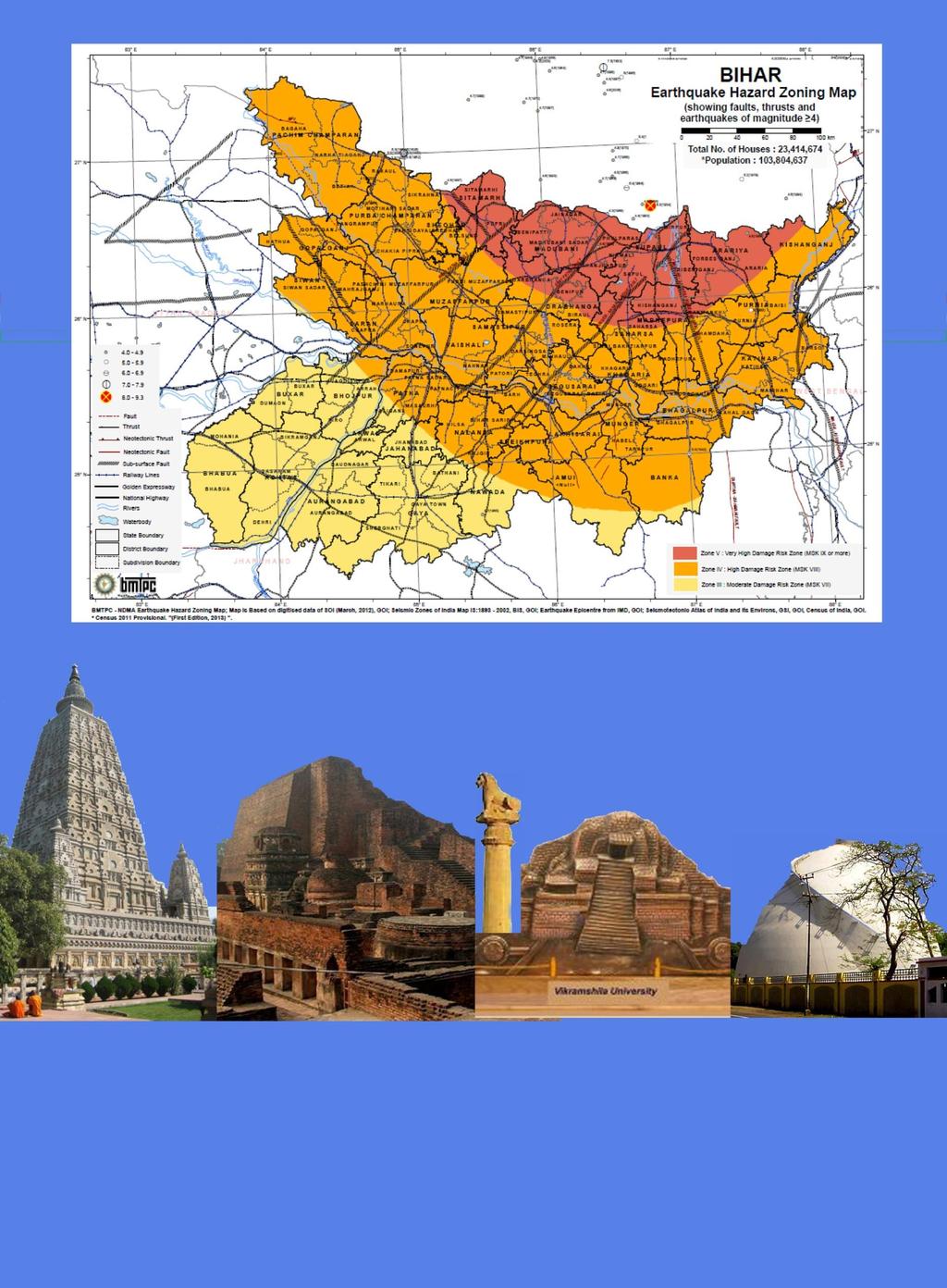
46
DISTRICTWISE ACHIEVEMENT OF CMHM
 DISTRICTWISE ACHIEVEMENT OF CMHM - 2016-17 Districtwise and Achievement under CMHM Fin. Year 2016-17 (Phy. in Hect./Nos., Fin. in Lakh Rs.) Sl. Districts Name Phy Fund Available in 2016-17 Achievement
FOURTH GRADE HAZARDS 1 WEEK LESSON PLANS AND ACTIVITIES
 FOURTH GRADE HAZARDS 1 WEEK LESSON PLANS AND ACTIVITIES PLATE TECTONIC CYCLE OVERVIEW OF FOURTH GRADE VOLCANOES WEEK 1. PRE: Comparing different structures of volcanoes. LAB: Modeling three types of volcanoes.
भ रत सरक र GOVERNMENT OF INDIA. Precipitation/TS Forecast For Districts of BIHAR भ रत म सम वज ञ न वभ ग
 भ रत सरक र GOVERNMENT OF INDIA भ रत म सम वज ञ न वभ ग म सम वज ञ न क दर, अ नस ब द, पटन बह र, पन क ड- 800002 INDIA METEOROLOGICAL DEPARTMENT METEOROLOGICAL CENTRE, ANISHABAD, PATNA, BIHAR PIN CODE800002 द
20.1 Earthquakes. Chapter 20 EARTHQUAKES AND VOLCANOES. Earthquakes and plate boundaries 500 UNIT 6 EARTH S STRUCTURE
 Chapter 20 EARTHQUAKES AND VOLCANOES 20.1 Earthquakes In Chapter 19, you read about the San Andreas Fault, which lies along the California coast (Figure 20.1). This fault passes right through San Francisco
Climate Change in Bihar, India:A Case Study
 Climate Change in Bihar, India:A Case Study L. B. Roy 1, M. Bhushan 2, R. Kumar 2 1,2 Civil Engineering Department, National Institute of Technology Patna Patna-800005, Bihar, India 1 lbroy@nitp.ac.in
HAZUS-MH: Earthquake Event Report
 HAZUS-MH: Earthquake Event Report Region Name: El Paso County Earthquake Scenario: El Paso County Random EQ Print Date: February 08, 2006 Disclaimer: The estimates of social and economic impacts contained
Released Science Inquiry Task Location Grade 11
 Date: Your Name: Released Science Inquiry Task Location 2009 Grade 11 Science Directions: You will be completing an extended-response inquiry task called Location. Explain the reasons for all of your answers.
earthquakes 1. Earthquakes occur when plates grind against one another along cracks called faults.
 earthquakes BEGIN 1 earthquakes 1. Earthquakes occur when plates grind against one another along cracks called faults. 2 earthquakes 1. Earthquakes occur when plates grind against one another along cracks
1. Why do earthquakes happen? 3. What type of mechanical waves are Primary or P waves? 4. What type of mechanical waves are Secondary or S waves?
 Name Period Earthquake Activity Background Information Earthquakes occur because of a sudden release of stored energy. This energy has built up over long periods of time as a result of tectonic forces
Section 19.1: Forces Within Earth Section 19.2: Seismic Waves and Earth s Interior Section 19.3: Measuring and Locating.
 CH Earthquakes Section 19.1: Forces Within Earth Section 19.2: Seismic Waves and Earth s Interior Section 19.3: Measuring and Locating Earthquakes Section 19.4: Earthquakes and Society Section 19.1 Forces
SCENARIO DESIGN ON THE IMPACT OF A HIGH-MAGNITUDE EARTHQUAKE IN THE CITY OF LIMA, PERU
 SCENARIO DESIGN ON THE IMPACT EARTHQUAKE IN THE CITY OF LIMA, Methodology Determination of the characteristics of the probable earthquake (magnitude, intensity, acceleration). Seismic geotechnical soil
Earthquakes. Dr. Mark van der Meijde INTERNATIONAL INSTITUTE FOR GEO-INFORMATION SCIENCE AND EARTH OBSERVATION
 Earthquakes Dr. Mark van der Meijde vandermeijde@itc.nl INTERNATIONAL INSTITUTE FOR GEO-INFORMATION SCIENCE AND EARTH OBSERVATION Topics to handle Theory of earthquakes Mechanism Strength Measurements
Magnitude 6.3, NORTH OF MOROCCO
 Earthquake location & overview A magnitude 6.3 earthquake struck in Alboran Sea, orth of Morocco; the epicentre was centered about 54 km ( 34 miles) E of Al Hoceima. The depth has been estimated to be
Mw 7.8, Southwest of Sumatra, Indonesia Wed, 2 March 2016 at 12:49:48 UTC M /03/03
 Earthquake overview AFGHANISTA N PAKISTA N INDIA A moment magnitude (Mw) 7.8 earthquake struck in South West, Indonesia. The epicentre was centered about 800 km West South West of Padang, Sumatra province,
Earthquakes. These icons indicate that teacher s notes or useful web addresses are available in the Notes Page.
 Earthquakes These icons indicate that teacher s notes or useful web addresses are available in the Notes Page. This icon indicates the slide contains activities created in Flash. These activities are not
VULNERABILITY FUNCTIONS FOR BUILDINGS BASED ON DAMAGE SURVEY DATA IN SRI LANKA AFTER THE 2004 INDIAN OCEAN TSUNAMI. Murao, O. 1, Nakazato, H.
 371 VULNERABILITY FUNCTIONS FOR BUILDINGS BASED ON DAMAGE SURVEY DATA IN SRI LANKA AFTER THE 2004 INDIAN OCEAN TSUNAMI Murao, O. 1, Nakazato, H. 2 1 Graduate School of Systems and Information Engineering,
The Magnitude 7.2 Earthquake from the West Valley Fault: Implications for Metro Manila and Nearby Provinces
 The Magnitude 7.2 Earthquake from the West Valley Fault: Implications for Metro Manila and Nearby Provinces First DRI Collegiate Conference in the Philippines 16 March 2017 Renato U. Solidum, Jr. Department
Earthquake. earthquake, epicenters in the U.S. Kobe, Japan deaths
 Kobe, Japan 1995 5000 deaths Earthquakes It is estimated that there are 500,000 detectable earthquakes in the world each year. 100,000 of those can be felt, and 100 of them cause damage. The world's deadliest
Section Forces Within Earth. 8 th Grade Earth & Space Science - Class Notes
 Section 19.1 - Forces Within Earth 8 th Grade Earth & Space Science - Class Notes Stress and Strain Stress - is the total force acting on crustal rocks per unit of area (cause) Strain deformation of materials
Disaster Risk Management in India. Kamal Kishore New Delhi, 27 October 2016
 Disaster Risk Management in India Kamal Kishore New Delhi, 27 October 2016 Hazard, Exposure and Vulnerability Disaster Prevention Mitigation Hurricane Matthew: Cuba & Haiti Emergency Response Coordination
Pacific Catastrophe Risk Assessment And Financing Initiative
 Pacific Catastrophe Risk Assessment And Financing Initiative VANUATU September 211 Country Risk Profile: VANUATU is expected to incur, on average, 48 million USD per year in losses due to earthquakes and
Pacific Catastrophe Risk Assessment And Financing Initiative
 Pacific Catastrophe Risk Assessment And Financing Initiative TIMOR-LESTE September Timor-Leste is expected to incur, on average, 5.9 million USD per year in losses due to earthquakes and tropical cyclones.
Report on Disaster statistics of Nepal
 Report on Disaster statistics of Nepal Submitted by Altaf Rehman Submitted to Dr. Naveed Ahmed University of engineering and technology Peshawar Assignment 1 Section A Registration id 14PWCIV456 Page 1
SEISMIC RISK ASSESSMENT IN ARMENIA
 SEISMIC RISK ASSESSMENT IN ARMENIA Hovhannes Khangeldyan Head of National Crisis Management Center Rescue Service Ministry of Emergency Situations of the Republic of Armenia Tokyo, 2016 ARMENIA: GEOGRAPHICAL
Earthquakes and Earth s Interior
 - What are Earthquakes? Earthquakes and Earth s Interior - The shaking or trembling caused by the sudden release of energy - Usually associated with faulting or breaking of rocks - Continuing adjustment
COMPREHENSIVE GIS-BASED SOLUTION FOR ROAD BLOCKAGE DUE TO SEISMIC BUILDING COLLAPSE IN TEHRAN
 COMPREHENSIVE GIS-BASED SOLUTION FOR ROAD BLOCKAGE DUE TO SEISMIC BUILDING COLLAPSE IN TEHRAN B. Mansouri 1, R. Nourjou 2 and K.A. Hosseini 3 1 Assistant Professor, Dept. of Emergency Management, International
Earthquakes. & Expansive Soils
 Earthquakes & Expansive Soils January 22, 2009 Plan Update Flanagan & Associates, LLC Consultants Tulsa, OK www.rdflanagan.com rdflanagan@rdflanagan.com Plan can be reviewed at: www.rdflanagan.com/.html
Earthquake hazards. Aims 1. To know how hazards are classified 2. To be able to explain how the hazards occur 3. To be able to rank order hazards
 Earthquake hazards Aims 1. To know how hazards are classified 2. To be able to explain how the hazards occur 3. To be able to rank order hazards Types of hazard Primary A direct result of the earthquake
Damage and Restoration of Drinking Water Systems Caused by 0206 Tainan Earthquake and Future Mitigation Measures
 Damage and Restoration of Drinking Water Systems Caused by 0206 Tainan Earthquake and Future Mitigation Measures Nan-Tzer Hu 1. Overview of 0206 Earthquake s At 03:57 local time (19:57 UTC) on 6 February
Your Task: Read each slide then use the underlined red or underlined information to fill in your organizer.
 Severe Weather: Tornadoes and Hurricanes Thunderstorms and Lightning S6E4 d. Construct an explanation of the relationship between air pressure, weather fronts, and air masses and meteorological events
Magnitude 6.3 SOUTH ISLAND OF NEW ZEALAND
 A magnitude 6.3 earthquake shook the southern New Zealand city of Christchurch. At least 100 people are reported dead, and there are reports of collapsed buildings, cracked streets and flooding due to
Pacific Catastrophe Risk Assessment And Financing Initiative
 Pacific Catastrophe Risk Assessment And Financing Initiative TUVALU is expected to incur, on average,. million USD per year in losses due to earthquakes and tropical cyclones. In the next 5 years, has
Earthquake Disaster Management in India
 Earthquake Disaster Management in India Akshay B. Ahlawat JRF in Geography Abstract: The fact is that natural disasters are always unexpected events which affect human life as well as nature itself. Earthquakes
Tornadoes pose a high risk because the low atmospheric pressure, combined with high wind velocity, can:
 Tornadoes are powerful, circular windstorms that may be accompanied by winds in excess of 200 miles per hour. Tornadoes typically develop during severe thunderstorms and may range in width from several
Comprehensive Emergency Management Plan
 Comprehensive Emergency Management Plan Section 6-Earthquake Annex Blank Intentionally 2 CEMP Annex 6 1 Earthquake Annex I. PURPOSE II. SITUATION The earthquake annex is a hazard-specific annex to be used
EPS 20: Earthquakes. Laboratory Exercise 1. Intensity
 Name GSI Name EPS 20: Earthquakes Laboratory Exercise 1 Intensity Purpose: To investigate seismic intensity and how it is used to describe the effects of earthquakes Background: Several hundred years ago,
Monthly Communicable Disease Surveillance Report (Summary of reporting % for P, L, S included)
") Integrated Diseases Surveillance ProGRAMME Monthly Communicable Disease Surveillance Report Monthly Communicable Disease Surveillance Report (Summary of reporting % for P, L, S included) MONTH: Mar 2018
Integrated Diseases Surveillance ProGRAMME Monthly Communicable Disease Surveillance Report Monthly Communicable Disease Surveillance Report (Summary of reporting % for P, L, S included) MONTH: Mar 2018
UGRC 144 Science and Technology in Our Lives/Geohazards
 UGRC 144 Science and Technology in Our Lives/Geohazards Session 3 Understanding Earthquakes and Earthquake Hazards Lecturer: Dr. Patrick Asamoah Sakyi Department of Earth Science, UG Contact Information:
Bridge Construction: Reducing Disaster Risk
 JAMMU-UDHAMPUR RAIL LINK Bridge Construction: Reducing Disaster Risk PROF MAHESH TANDON MANAGING DIRECTOR, TANDON CONSULTANTS PVT LTD GUEST PROFESSOR @ GANDHINAGAR FORMER DISTINGUISHED VISITING PROFESSOR
NPTEL Video Course on Geotechnical Earthquake Engineering
 NPTEL Video Course on Geotechnical Earthquake Engineering by Prof. Deepankar Choudhury Professor, Dept. of Civil Engg., Indian Institute of Technology (IIT) Bombay Powai, Mumbai 400076, India. Email: dc@civil.iitb.ac.in
Appendix 2. Extracts from Ministry for the Environment Active Fault Guidelines 2003
 Extracts from Ministry for the Environment Active Fault Guidelines 2003 Published in July 2003 by the Ministry for the Environment Manatu Mo Te Taiao PO Box 10-362, Wellington, New Zealand ISBN: 0-478-18901
COMMUNITY EMERGENCY RESPONSE TEAM TORNADOES
 Tornadoes are powerful, circular windstorms that may be accompanied by winds in excess of 200 miles per hour. Tornadoes typically develop during severe thunderstorms and may range in width from several
Monthly Communicable Disease Surveillance Report (Summary of reporting % for P, L, S included)
") Integrated Diseases Surveillance ProGRAMME Monthly Communicable Disease Surveillance Report Monthly Communicable Disease Surveillance Report (Summary of reporting % for P, L, S included) MONTH: May 2018
Integrated Diseases Surveillance ProGRAMME Monthly Communicable Disease Surveillance Report Monthly Communicable Disease Surveillance Report (Summary of reporting % for P, L, S included) MONTH: May 2018
Downtown Anchorage Seismic Risk Assessment & Land Use Regulations to Mitigate Seismic Risk
 Prepared for: The Municipality of Anchorage Planning Department and the Geotechnical Advisory Commission Downtown Anchorage Seismic Risk Assessment & Land Use Regulations to Mitigate Seismic Risk Prepared
Ground motion intensity map of the Tainan earthquake (Central Weather Bureau).
.") Taiwan lies on the boundary between the Eurasian Plate and the Philippine Sea Plate, which are converging at 80 mm per year. The island is the result of uplift caused by the collision of the northern end
Taiwan lies on the boundary between the Eurasian Plate and the Philippine Sea Plate, which are converging at 80 mm per year. The island is the result of uplift caused by the collision of the northern end
Pacific Catastrophe Risk Assessment And Financing Initiative
 Pacific Catastrophe Risk Assessment And Financing Initiative PALAU September is expected to incur, on average,.7 million USD per year in losses due to earthquakes and tropical cyclones. In the next 5 years,
Initiative. Country Risk Profile: papua new guinea. Better Risk Information for Smarter Investments PAPUA NEW GUINEA.
 Pacific Catastrophe Risk Assessment And Financing Initiative PAPUA NEW GUINEA September 211 Country Risk Profile: papua new is expected to incur, on average, 85 million USD per year in losses due to earthquakes
An earthquake can cause:
 Earthquakes An earthquake is a sudden rapid shaking of the earth. They are caused by the breaking and shifting of the rock beneath the earth s surface. Often found in conjunction with Plate tectonic boundaries.
Lesson 8. Natural Disasters
 Lesson 8 Natural Disasters 1 Reading is NOT a spectator sport! 2 Reading requires active participation! 3 PREDICT Try to figure out what information will come next and how the selection might end. 4 Natural
INTRODUCTION. Climate
 INTRODUCTION Climate Landslides are serious natural disasters in many parts of the world. Since the past 30 years, rainfall triggered landslides and debris flows had been one of the natural disasters of
Earthquakes Science & Safety. Ms Joan L. Latchman Seismologist Seismic Research Unit
 Earthquakes Science & Safety Ms Joan L. Latchman Seismologist Seismic Research Unit Summary Trinidad lies in an area of high earthquake activity for the Caribbean. Earthquake safety tips should be practiced
Earthquake Damage Scenario
 Chapter 2. Earthquake Damage Scenario CHAPTER 2. EARTHQUAKE DAMAGE SCENARIO 2.1 Earthquake Scenario Setting and Ground Motion 2.1.1 Fault in the Philippines The Philippines is located in latitude 5 to
Earthquake Disaster Assessment on May 27 Ms 6.2 Yogyakarta Earthquake of Indonesia
 Earthquake Disaster Assessment on May 27 Ms 6.2 Yogyakarta Earthquake of Indonesia Qu Guosheng, Zhao Fengxin, Huang Jianfa, Li Yigang, Li Yanfeng, Du Xiaoxia and Ning Baokun1 National Earthquake Response
September 28, 2004 Parkfield Earthquake
 PRELIMINARY REPORT ON SEPTEMBER 28, 2004 PARKFIELD EARTHQUAKE By Rakesh K. Goel, M.EERI and Charles B. Chadwell, M. EERI Department of Civil & Environmental Engineering, California Polytechnic State University,
M 7.1 EARTHQUAKE 5KM ENE OF RABOSO, MEXICO EXACT LOCATION: N W DEPTH: 51.0KM SEPTEMBER 19, 1:14 LOCAL TIME
 M 7.1 EARTHQUAKE 5KM ENE OF RABOSO, MEXICO EXACT LOCATION: 18.584 N 98.399 W DEPTH: 51.0KM SEPTEMBER 19, 2017 @ 1:14 LOCAL TIME Photo: Eduardo Verdugo / AP Photo: Alfredo Estrella/ Agence France-Presse/
NPTEL Online - IIT Kanpur. Course Name Geotechnical Earthquake Engineering. Department IIT Kanpur
 NPTEL Online - IIT Kanpur Course Name Geotechnical Earthquake Engineering Department Instructor Civil Engineering Department IIT Kanpur Prof. N.R. Patra Module 1 INTRODUCTION TO GEOTECHNICAL ENGINEERING
Assessing Spatial Vulnerability for Landslide Threat in Hilly Areas of The Nilgiris, Tamil Nadu, India
 Assessing Spatial Vulnerability for Landslide Threat in Hilly Areas of The Nilgiris, Tamil Nadu, India by G.P.Ganapathy, Centre for Disaster Mitigation and Management, VIT University, Vellore 632014, India,
Technical Article TRICOLITE. Pledged to Excellence SAFE, EFFICIENT, RELIABLE POWER DISTRIBUTION SOLUTIONS
 Technical Article SAFE, EFFICIENT, RELIABLE POWER DISTRIBUTION SOLUTIONS EARTHQUAKES & SEISMIC COMPLIANCE OF LV SWITCHGEAR ASSEMBLY Random vibrations, such as those caused by an earthquake, cause shocks
Online Supplementary Material for: Heterogeneous Peer Effects and Rank Concerns: Theory and Evidence
 Online Supplementary Material for: Heterogeneous Peer Effects and Rank Concerns: Theory and Evidence Michela M. Tincani 1 November 12, 2014 1 Tincani: University College London, 30 Gordon Street, London,
M-8.1 EARTHQUAKE 87KM SW OF PIJIJIAPAN, MEXICO EXACT LOCATION: N W DEPTH: 69.7KM SEPTEMBER 7, 11:49 PST
 M-8.1 EARTHQUAKE 87KM SW OF PIJIJIAPAN, MEXICO EXACT LOCATION: 15.068 N 93.715 W DEPTH: 69.7KM SEPTEMBER 7, 2017 @ 11:49 PST Photo: Luis Alberto Cruz / AP Photo: Carlos Jasso 1 THE 2017 CHIAPAS MEXICO
Borah Peak Earthquake HAZUS Scenario Project Executive Summary Idaho Bureau of Homeland Security Idaho Geological Survey Western States Seismic
 Borah Peak Earthquake HAZUS Scenario Project Executive Summary Idaho Bureau of Homeland Security Idaho Geological Survey Western States Seismic Policy Council 12/30/2008 The HAZUS-MH analysis of the Borah
Earthquakes Science & Safety. Dr. Richard Robertson Geologist & Head Seismic Research Unit
 Earthquakes Science & Safety Dr. Richard Robertson Geologist & Head Seismic Research Unit Summary The Eastern Caribbean islands are in a seismically active part of the world. Earthquake safety tips should
Monthly Communicable Disease Surveillance Report (Summary of reporting % for P, L, S included)
") Integrated Diseases Surveillance Project Monthly Communicable Disease Surveillance Report Monthly Communicable Disease Surveillance Report (Summary of reporting % for P, L, S included) MONTH: JUNE 2014
Integrated Diseases Surveillance Project Monthly Communicable Disease Surveillance Report Monthly Communicable Disease Surveillance Report (Summary of reporting % for P, L, S included) MONTH: JUNE 2014
KENTUCKY HAZARD MITIGATION PLAN RISK ASSESSMENT
 KENTUCKY HAZARD MITIGATION PLAN RISK ASSESSMENT Presentation Outline Development of the 2013 State Hazard Mitigation Plan Risk Assessment Determining risk assessment scale Census Data Aggregation Levels
How to Use This Presentation
 How to Use This Presentation To View the presentation as a slideshow with effects select View on the menu bar and click on Slide Show. To advance through the presentation, click the right-arrow key or
2.3 Notes: Earthquake Damage Can Be Reduced
 2.3 Notes: Earthquake Damage Can Be Reduced Earthquakes can cause severe damage and loss of life Each year, there is about one earthquake with a magnitude of or higher-this is an extremely earthquake.
Earthquakes and Earth s Chapter. Interior
 Earthquakes and Earth s Chapter Interior 8.1 What Is an Earthquake? An earthquake is the vibration of Earth produced by the rapid release of energy Focus and Epicenter Focus is the point within Earth
Year 8 Level: 5-8 GEOGRAPHY Time: 1:30min
 Year 8 Level: 5-8 GEOGRAPHY Time: 1:30min Name: Class: Answer all questions in the space provided. 1. Label the diagram below using the following words; (4) mantle, crust, outer core, inner core 2. Write
EARTHQUAKES AND EARTHQUAKE-RESISTANT DESIGN OF STRUCTURES. Er. K. S. BHARGAV LECTURER Department of Civil Engineering, GGSGP CHEEKA
 EARTHQUAKES AND EARTHQUAKE-RESISTANT DESIGN OF STRUCTURES by Er. K. S. BHARGAV LECTURER Department of Civil Engineering, GGSGP CHEEKA SCOPE OF PRESENTATION EARTHQUAKE AND ITS CHARACTERIZATION EARTHQUAKE-RESISTANT
Flash flood disaster in Bayangol district, Ulaanbaatar
 Flash flood disaster in Bayangol district, Ulaanbaatar Advanced Training Workshop on Reservoir Sedimentation Management 10-16 October 2007. IRTCES, Beijing China Janchivdorj.L, Institute of Geoecology,MAS
Flexible soils amplified the damage in the 2010 Haiti earthquake
 Earthquake Soil Interaction 45 Flexible soils amplified the damage in the 2010 Haiti earthquake R. O. de León Sciences Academy of the Dominican Republic, Dominican Republic Abstract On January 12 th, 2010,
Tornadoes. Tornadoes COMMUNITY EMERGENCY RESPONSE TEAM TORNADOES
 Tornadoes Tornadoes Tell the participants that tornadoes are powerful, circular windstorms that may be accompanied by winds in excess of 200 miles per hour. Tornadoes typically develop during severe thunderstorms
Earthquake Hazards. Tsunami
 Earthquake Hazards Tsunami Measuring Earthquakes Two measurements that describe the power or strength of an earthquake are: Intensity a measure of the degree of earthquake shaking at a given locale based
Tsukuba, Japan International Institute of Seismology and Earthquake Engineering Building Research Institute STUDY TRIP TO ITAKO CITY
 Tsukuba, Japan International Institute of Seismology and Earthquake Engineering Building Research Institute STUDY TRIP TO ITAKO CITY A Technical Report By MARTINEZ BRAVO Delvin Abdiel (MEE10515) Disaster
TOM NEWBY SCHOOL EXAMINATION
 1 TOM NEWBY SCHOOL EXAMINATION Subject Geography Examiner Miss M Albertyn Date 15 June 2017 Total marks 75 Session 1 Duration 1½ hours Grade 7 Moderator Mrs W Pienaar Special instructions/ Equipment This
ILO Assessment Report: Community Based Emergency Employment Nabulini, Manu and Naibita Village.
 ILO Assessment Report: Community Based Emergency Employment Nabulini, Manu and Naibita Village. Back ground: The category 5 tropical cyclone Winston (TCW) which made landfall in Fiji on 20th February 2016
A Review of Concept of Peri-urban Area & Its Identification
 A Review of Concept of Peri-urban Area & Its Identification Ar. Manita Saxena Research Scholar Department of Architecture and Planning M.A.N.I.T, Bhopal Dr. Supriya Vyas Assistant Professor, Department
An Unexpected Catastrophe: Anniversary of the 1989 Newcastle. The 1989 Earthquake. By Dr. Khosrow Shabestari and Dr. Peeranan Towashiraporn
 An Unexpected Catastrophe: Anniversary of the 1989 Newcastle Earthquake Editor s note: Twenty years ago this month, the deadliest earthquake 12.2009 AIRCurrents on Australian soil occurred near Newcastle,
Natural Disasters Spring, LECTURE #8: Earthquake Disasters: Monitoring & Mitigation. Date: 1 Feb 2018 (lecturer: Dr.
 GEOL 0820 Ramsey Natural Disasters Spring, 2018 LECTURE #8: Earthquake Disasters: Monitoring & Mitigation Date: 1 Feb 2018 (lecturer: Dr. Shawn Wright) I. Exam I - Reminder Feb 6 th next class details:
ENVI.2030L - Earthquakes
 ENVI.2030L - Earthquakes Name I. Introduction The crust of the earth behaves in a brittle manner. Stress is the force applied to a brittle substance and strain represents the build-up of energy in the
Seismic vulnerability in Latinamerica Speaker: Rafael Osiris de León Sciences Academy of Dominican Republic.
 Seismic vulnerability in Latinamerica Speaker: Rafael Osiris de León Sciences Academy of Dominican Republic. IANAS GENERAL ASSEMBLY Punta Cana, 16-20 July, 2013 TECTONIC PLATES AND EARTHQUAKES Pacific
Three Fs of earthquakes: forces, faults, and friction. Slow accumulation and rapid release of elastic energy.
 Earthquake Machine Stick-slip: Elastic Rebound Theory Jerky motions on faults produce EQs Three Fs of earthquakes: forces, faults, and friction. Slow accumulation and rapid release of elastic energy. Three
Goals In this activity you will:
 Activity 3 How Big Was It? Goals In this activity you will: Rank the effects of earthquakes. Map the intensity of earthquakes. Interpret a map of earthquake intensity to infer the general location of the
Earthquake Hazards. Tsunami
 Earthquake Hazards Tsunami Review: What is an earthquake? Earthquake is the vibration (shaking) and/or displacement of the ground produced by the sudden release of energy. The point inside the Earth where
SHAKING AND GROUND FAILURE-INDUCED DAMAGE TO BUILDINGS BY THE 2010 AND 2011 CHRISTCHURCH EARTHQUAKES AND ITS LESSONS
 Int. Journal for Housing Science, Vol.36, No.3 pp.162-169, 2012 Published in the United States SHAKING AND GROUND FAILURE-INDUCED DAMAGE TO BUILDINGS BY THE 2010 AND 2011 CHRISTCHURCH EARTHQUAKES AND ITS
Hawke s Bay Liquefaction Hazard Report - Frequently Asked Questions
 Hawke s Bay Liquefaction Hazard Report - Frequently Asked Questions What is liquefaction? Liquefaction occurs when an earthquake shakes up water-logged sediments. As a result, the soil behaves like a liquid
Development and Implementation of the Japanese Enhanced Fujita Scale
 Development and Implementation of the Japanese Enhanced Fujita Scale May 2018 Japan Meteorological Agency (JMA) The Japan Meteorological Agency released its Guidelines for the Japanese Enhanced Fujita
4/22/2011. Skill sharing session AVC what makes the ground tremble? What to do before. What to do during. What to do after
 Skill sharing session AVC 2011 Session Objectives what makes the ground tremble? What to do before What to do during What to do after Definition of earthquake Earthquake causes Characteristic of earthquake
A Presentation By: Dr. G. M. Dar Centre for Disaster Management & Env. Studies, J&K IMPA, Srinagar
 A Presentation By: Dr. G. M. Dar Centre for Disaster Management & Env. Studies, J&K IMPA, Srinagar Introduction Disaster: Sudden or great misfortune. A catastrophe, a calamitous event. Hazards are a natural
Introduction to Engineering Seismology
 Introduction to Engineering Seismology Sudhir K Jain Mythology The Myths 2 The Earth is held up by 4 elephants that stand on the back of a turtle. The turtle is balanced in turn on a cobra. When any of
Disaster RISK Management : Bhutanese Scenario
 Disaster RISK Management : Bhutanese Scenario Expert Group Meeting (EGM) on Geo-referenced Information Systems for Disaster Risk Management (Geo-DRM) and sustaining the Community of Practice (COP), Bangkok,
Montserrat Eruption = Monster rat
 Montserrat Eruption 1997 = Monster rat Small island in the Caribbean sea Montserrat is a small... Soufriere Hills volcano Key facts: Date: 25 th June 1997 (small eruptions began in July 1995) Size: 4.5
Vulnerability of Bangladesh to Cyclones in a Changing Climate
 Vulnerability of Bangladesh to Cyclones in a Changing Climate Susmita Dasgupta Kiran Pandey Mainul Huq Zahirul Huq Khan M.M. Zahid Ahmed Nandan Mukherjee Malik Fida Khan 2010 Bangladesh: Tropical Cyclone
Paper Reference. Paper Reference(s) 1312/2F Edexcel GCSE Geography A Foundation Tier. Monday 11 June 2007 Afternoon Time: 1 hour 15 minutes
 1312/2F Edexcel GCSE Geography A Foundation Tier. Monday 11 June 2007 Afternoon Time: 1 hour 15 minutes") Centre No. Paper Reference Surname Initial(s) Candidate No. 1 3 1 2 2 F Signature Paper Reference(s) 1312/2F Edexcel GCSE Geography A Foundation Tier Paper 2F Monday 11 June 2007 Afternoon Time: 1 hour
Centre No. Paper Reference Surname Initial(s) Candidate No. 1 3 1 2 2 F Signature Paper Reference(s) 1312/2F Edexcel GCSE Geography A Foundation Tier Paper 2F Monday 11 June 2007 Afternoon Time: 1 hour
9. GEOLOGY, SOILS, AND MINERALS
 June 28, 2018 Page 9-1 9. GEOLOGY, SOILS, AND MINERALS This EIR chapter describes the existing geological, soil, and mineral conditions in the planning area. The chapter includes the regulatory framework
Satellite Image. False-color IR satellite view of basins and ranges north of Snake River Plain Lost River Rangelower. Lemhi Range-upper.
 Satellite Image False-color IR satellite view of basins and ranges north of Snake River Plain Lost River Rangelower center Lemhi Range-upper center Challis, Idaho is left of center Epicenter of 1983, magnitude
Earthquakes An introduction to earthquake monitoring techniques
 Earthquakes An introduction to earthquake monitoring techniques TEACHER S COPY Aims To understand what an earthquake is and where they occur To gain an insight into how earthquakes are recorded and how
Geohazards and disaster risk reduction
 Geohazards and disaster risk reduction Susanne Sargeant 8 November 2017 Overview University and my PhD Seismology at BGS Learning other skills Working at the interface between science and resilience building
SAMPLE QUESTION PAPER SET-II CLASS XII SUBJECT- GEOGRAPHY (029)
") SAMPLE QUESTION PAPER SET-II CLASS XII SUBJECT- GEOGRAPHY (029) 2015-2016 TIME ALLOWED- 3 HRS. MAXIMUM MARKS-70 General Instructions: I. There are 22 questions in all. II. III. IV. All questions are compulsory.
SAMPLE QUESTION PAPER SET-II CLASS XII SUBJECT- GEOGRAPHY (029) 2015-2016 TIME ALLOWED- 3 HRS. MAXIMUM MARKS-70 General Instructions: I. There are 22 questions in all. II. III. IV. All questions are compulsory.
Bangladesh in Risk of Earthquake: What Can Be Done. Presented By : Md.Jahangir Alam Coordinator, Disaster Management Unit Dhaka Ahsania Mission
 Bangladesh in Risk of Earthquake: What Can Be Done Presented By : Md.Jahangir Alam Coordinator, Disaster Management Unit Dhaka Ahsania Mission What are Earthquakes? The shaking /ground vibration caused