Assessing Spatial Vulnerability for Landslide Threat in Hilly Areas of The Nilgiris, Tamil Nadu, India
|
|
|
- Dortha O’Brien’
- 5 years ago
- Views:
Transcription

1 Assessing Spatial Vulnerability for Landslide Threat in Hilly Areas of The Nilgiris, Tamil Nadu, India by G.P.Ganapathy, Centre for Disaster Mitigation and Management, VIT University, Vellore , India, Dharma Rao, Director-National Intelligence Grid, Ministry of Home Affairs, Govt. of India, New Delhi , India, Sekar S.K, Centre for Disaster Mitigation and Management, VIT University, Vellore , India

2 Landslide Hazard Zonation Map of India 3% 7% 30% 60%
3 Agencies involved Geological Survey of India (GSI) Central Road Research Institute (CRRI) Central Building Research Institute (CBRI) Indian Institute of Technology, Roorkee (IIT-R) Wadia Institute of Himalayan Geology (WIHG) Department of Space (DoS) National Remote Sensing Centre (NRSC) Defence Terrain Research Laboratory (DTRL) Bureau of Indian Standards (BIS) some academic institutions, and individual experts.


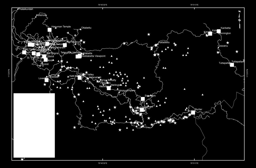
4 Study Area

5

6 The Nilgiri s Revenue Taluks

7 Population growth in Nilgiri District Area 2500Sq.km Lakhs 7.62 Lakhs
8 General causes of Landslides Addition of Moisture (Extensive Rainfall) Removal of Vegetation (Timbering) Addition of Weight (Buildings in Top) Over steepening Vibrations These factors will act either individually or in combination.

9 Landslide Occurrences Since 1865 in Nilgiris 300 LS
10 Landslide Occurrences Since 1865 in Nilgiris

11 Geological Map
12 Geomorphological Map

13 Topography - Coonoor to Ooty

14 Aerial view of Coonoor to Ooty

15 Monthly Normal Rainfall in Nilgiri District
16 November 2009 Landslides Heavy rains triggered a series of landslides in Ooty, Coonoor and Kotagiri regions of the Nilgiris Killed 42 people within 48 hours. Total Deaths 80. Estimated loss about 300 Crores

17 Spatial Distribution - November 2009 Landslides RF: 19cm RF: 82cm RF: 31cm

18 Daily Rainfall from November 2009
19 November 2009 Landslides Lessons Learned Many slides have taken place in areas of intense cultural activity. agricultural operations, construction of buildings and roads removal of earth and rock levelling of slopes deforestation and blocking of natural drainage.
20 November 2009 Landslides Lessons Learned Considering all these evidences the following factors appear to have been involved, singly or in combination, in inducing the landslides. Water (Heavy rainfall) Toe Removal Increase of Head Load
21 Lovedale Road view from Coonoor Road Increase of Head Load Toe Removal Water

22 Closer View

23 Closer View

24 Closer View

25 Lovedale Road View from Coonoor Road Landslide Scenario


26 Zone of Crack Lovedale Road at Thalayattu Mandu on top and bottom side showing the Zone of Crack and Zone of Failure Zone of Failure

27 Houses built in the Stream Channel Severe Damage at Naduhatti

28 Debris covered at Naduhatti

29 Severely Damaged Road - Ooty Coonoor Road near Thalayattu Mund Junction.


30 Ooty Coonoor NH. 2 kms from Valley View point. No way beyond this point.


31 Near Sagar Holiday Resorts, Valley View.
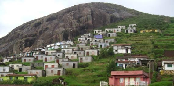
32 Unplanned colonization

33

34 Lessons for the Planners and public 2009 landslides Severe to High Landslide Areas identified by GSI in 1982

35 Landslide hazard zonal significance (BMTPC, Landslide Hazard Zonation Atlas of India 2003)
36 Tourism in Nilgiris Nilgiris District has tremendous potential for tourism. Several places in this district like Ooty. Coonoor and the Mudumalai sanctuary are well known to tourists all over India and the world. The district is blessed with abundance of natural beauty and a variety of wild life. The salubrious climate is a major attraction to the tourists. It is estimated that during loan season an average inflow of about persons per day is noted. The tourists visiting the town present a cross section. The foreign tourists account for about persons in a year.

37 Tourist Places
38 Landslide Inventories
39 Spatial Vulnerability Analysis Establishing the degree of vulnerability of buildings and lifeline utilities, one can obtain an estimate of risk. Vulnerability analysis is, therefore, an intrinsic aspect of disaster mitigation and one of the linkages in the assessment process. The Nilgiris district spatial vulnerability is assessed in three categories viz., built environment, critical facilities (essential and high potential loss), and transportation & lifeline utilities. The details are
40 Critical Facilities 1.Essential facilities hospitals, medical clinics, schools/educational institutions, fire stations, police stations and emergency operations facilities 2.High potential loss facilities dams, levees, military installations, nuclear power plants and hazardous material sites
41 Lifeline Inventory 1. Transportation highways, railways, bus, ports, ferry and airports 2. Lifeline Utility potable water, wastewater, natural gas, crude & refined oil, electric power and communications.
42 Critical Facility/Life line Inventory Analysis The Ooty town has, two colleges, one Polytechnic 12 primary school and 9 secondary schools. The town has 2 Government Hospitals, 4 private hospitals, 3 municipal dispensaries and an eye hospital. The roads, lanes and by lanes constitute predominant land use. This is inevitable as the palaces, bungalows are scattered and the topography demands the type of roads. The Ooty town has partial underground drainage which was laid 100 years ago. This covers an area of sq.km. Out of a total corporate area of 30.94sq.kms. There were 5165 service connections which have been provided under sewerage scheme. Out of 36 utilities in the study area about 65% critical facilities and 36% of transportation and life line utilities are vulnerable to severe landslide threat.


43 Landslide Hazard
44 Vulnerable facilities of Nilgiris Sl.No Facilities Total Falls Under Percentage High to Moderate Hazard Areas 1 Essential % 2 Lifeline % 3 Transportation % 4 Village/Towns %
45 Recommendations/ Conclusions

46 Dangerous Slopes

47 Blocking the Natural Draines

48 We Don t Bother
49 Recommendations/Conclusions 1. In order to reduce the enormous destructive potential of landslides and to minimise the consequential losses, it is necessary that Risk should be calculated. 2. Most of the topographic maps of hilly terrain of Nilgiris which are used as base maps for carrying out various studies including landslide investigation and mapping are available in small scale of 1:50,000 and a very few in 1:25, Small scale maps typically represent extensive areas, but they offer only a gross perspective on details.


50 3. The potential for accuracy drops as the area mapped grows larger and the scale grows smaller. Such scaled maps are not suitable for in-depth and accurate landslide investigations and instrumented monitoring. 4. A large-scale map, which shows a limited amount of space and provides a considerable amount of detailed information about that space can only be used for detailed landslide investigations, mapping and monitoring. 5. From the study it has been found that the eastern part of the study area is more prone to landslides. The historical landslide inventories very clearly reveal most of the landslides are trigged by the human and cultural activities.
51 6. Strengthening of buildings and infrastructure should lead to reduction in Vulnerability. The vulnerability of the buildings, critical facilities, lifeline structures should be studied thoroughly for further planning purposes. 7. The present vulnerability study is based in spatial distribution and relative risk based. However the likely damage to structures should be categorised in different grades depending on their impact and landslide types. 8. The out put of the present study can be used as first hand information for the decision makers and planners and also helpful for the further developmental activities in the landslide prone areas of Nilgiris District of India.

52 Monitoring Additional rain gauge stations may be installed in close interval and monitor the intense rainfall as well as the existing unstable slopes.

53 Destination- Disaster Free India
BASIC DETAILS. Morphometric features for landslide zonation A case study for Ooty Mettupalayam highway
 BASIC DETAILS Paper reference number : MWF PN 121 Title of the paper Name of the Presenter Author affiliation Mailing address Email address : Extraction of Topographic and Morphometric features for landslide
HAZUS-MH: Earthquake Event Report
 HAZUS-MH: Earthquake Event Report Region Name: El Paso County Earthquake Scenario: El Paso County Random EQ Print Date: February 08, 2006 Disclaimer: The estimates of social and economic impacts contained
CSIR-Central Building Research Institute, Roorkee (UK)
") CSIR-Central Building Research Institute, Roorkee (UK) Introduction: Training programme on Control Measures for Landslides held during July 18-22, 2016 Landslides problem in hilly terrains are one of the
CSIR-Central Building Research Institute, Roorkee (UK) Introduction: Training programme on Control Measures for Landslides held during July 18-22, 2016 Landslides problem in hilly terrains are one of the
INTERNATIONAL JOURNAL OF GEOMATICS AND GEOSCIENCES Volume 1, No 1, 2010
 An Integrated Approach with GIS and Remote Sensing Technique for Landslide Hazard Zonation S.Evany Nithya 1 P. Rajesh Prasanna 2 1. Lecturer, 2. Assistant Professor Department of Civil Engineering, Anna
1. INTRODUCTION. EXAMPLE OF SECHILIENNE ROCKFALL (France)
") FORM OSE POST-GRADUATE COURSE Landslide vulnerability and risk 1 FORM OSE POST-GRADUATE COURSE Landslide vulnerability and risk 2 FORM OSE POST-GRADUATE COURSE Landslide vulnerability and risk 3 Christophe
FORM OSE POST-GRADUATE COURSE Landslide vulnerability and risk 1 FORM OSE POST-GRADUATE COURSE Landslide vulnerability and risk 2 FORM OSE POST-GRADUATE COURSE Landslide vulnerability and risk 3 Christophe
RISK OF PRINCIPAL DISASTERS IN INDIA AND IMPACTS OF DISASTERS ON ECONOMIC DEVELOPMENT
 RISK OF PRINCIPAL DISASTERS IN INDIA AND IMPACTS OF DISASTERS ON ECONOMIC DEVELOPMENT At the Himachal Pradesh Institute of Public Administration Shimla 05. 05.2012 Improve Disaster Management with the
GENERAL. CHAPTER 1 BACKGROUND AND PURPOSE OF THE GUIDELINES Background of the Guidelines Purpose of the Guidelines...
 GENERAL CHAPTER 1 BACKGROUND AND PURPOSE OF THE GUIDELINES... 1 1.1 Background of the Guidelines... 1 1.2 Purpose of the Guidelines... 3 CHAPTER 2 APPLICATION OF THE GUIDELINES... 3 2.1 Potential Users
Need of Proper Development in Hilly Urban Areas to Avoid
 Need of Proper Development in Hilly Urban Areas to Avoid Landslide Hazard Dr. Arvind Phukan, P.E. Cosultant/Former Professor of Civil Engineering University of Alaska, Anchorage, USA RI District Governor
International Journal of Modern Trends in Engineering and Research e-issn No.: , Date: April, 2016
 International Journal of Modern Trends in Engineering and Research www.ijmter.com e-issn No.:2349-9745, Date: 28-30 April, 2016 Landslide Hazard Management Maps for Settlements in Yelwandi River Basin,
Interpretive Map Series 24
 Oregon Department of Geology and Mineral Industries Interpretive Map Series 24 Geologic Hazards, and Hazard Maps, and Future Damage Estimates for Six Counties in the Mid/Southern Willamette Valley Including
Outline of Guideline for Development and Utilization of Tsunami Disaster Management Map
 Outline of Guideline for Development and Utilization of Tsunami Disaster Management Map Port and Airport Research Institute, Japan The Overseas Coastal Area Development Institute of Japan Ports and Harbours
Landslide Hazard Zonation Methods: A Critical Review
 International Journal of Civil Engineering Research. ISSN 2278-3652 Volume 5, Number 3 (2014), pp. 215-220 Research India Publications http://www.ripublication.com/ijcer.htm Landslide Hazard Zonation Methods:
9/13/2011 CHAPTER 9 AND SUBSIDENCE. Case History: La Conchita Landslide. Introduction
 CHAPTER 9 SLOPE PROCESSES, LANDSLIDES, AND SUBSIDENCE Case History: La Conchita Landslide La Conchita: small coastal community 80 km (50 mi) northwest of Los Angeles Landslide occurred on January 10, 2005
APPLICATION OF REMOTE SENSING & GIS ON LANDSLIDE HAZARD ZONE IDENTIFICATION & MANAGEMENT
 APPLICATION OF REMOTE SENSING & GIS ON LANDSLIDE HAZARD ZONE IDENTIFICATION & MANAGEMENT PRESENTED BY SUPRITI PRAMANIK M.TECH IN ENVIRONMENTAL SCIENCE AND TECHNOLOGY NIT,DURGAPUR 25-04-2015 1 INTRODUCTION
Vulnerability Mapping for Disaster Assessment Using ArcGIS Tools and Techniques for Mumbai City, India
 Vulnerability Mapping for Disaster Assessment Using ArcGIS Tools and Techniques for Mumbai City, India Reshma Raskar-Phule Assistant Professor, Department of Civil Engineering, Sardar Patel College of
Landslide Forecasting and Warning Mechanism
 Annual Conference of Relief Commissioners, Disaster Management 18 May 2018, Vigyan Bhawan, New Delhi Landslide Forecasting and Warning Mechanism Dr. Saibal Ghosh Director, GSI, New Delhi Understanding
Roadmap to Stability
 Landslide Policy Committee for Aizawl City February 2014 Technical Support by: Aizawl is in earthquake hazard zone V and highly prone to natural, man-made and earthquake induced landslides. In order to
Georeferencing and Satellite Image Support: Lessons learned, Challenges and Opportunities
 Georeferencing and Satellite Image Support: Lessons learned, Challenges and Opportunities Shirish Ravan shirish.ravan@unoosa.org UN-SPIDER United Nations Office for Outer Space Affairs (UNOOSA) UN-SPIDER
3/8/17. #20 - Landslides: Mitigation and Case Histories. Questions for Thought. Questions for Thought
 #20 - Landslides: Mitigation and Case Histories Web Exercise #3 (Volcanoes) Due Wednesday There is a 2-point penalty for every day the assignment is late. Exam 1 Scores Scores and exam key are posted Vaiont
They include earthquakes, volcanic eruptions, floods, landslides, and other processes and occurrences. They are included in the broader concept of.
 They include earthquakes, volcanic eruptions, floods, landslides, and other processes and occurrences. They are included in the broader concept of. In general, natural processes are labeled hazardous only
2014 Summer training course for slope land disaster reduction Taipei, Taiwan, Aug
 MINISTRY OF SCIENCE AND TECHNOLOGY HYDROTECH RESEARCH INSTITUTE MINISTRY OF NATURAL RESOURCES AND ENVIRONMENT VIETNAM INSTITUTE OF GEOSCIENCES AND MINERAL RESOURCES (VIGMR) 2014 Summer training course
SLOPE PROCESSES, LANDSLIDES, AND SUBSIDENCE
 CHAPTER 9 SLOPE PROCESSES, LANDSLIDES, AND SUBSIDENCE La Conchita slide January 10, 2005 Triggered by heavy rainfall, reactivation along an older landslide surface (35,000 years ago, 6000 years ago, and
USING 3D GIS TO ASSESS ENVIRONMENTAL FLOOD HAZARDS IN MINA
 King Fahd University of Petroleum & Minerals College of Environmental Design Geographical Information system USING 3D GIS TO ASSESS ENVIRONMENTAL FLOOD HAZARDS IN MINA Prepared by : Ali AL-Zahrani OUTLINE
9/23/2013. Introduction CHAPTER 7 SLOPE PROCESSES, LANDSLIDES, AND SUBSIDENCE. Case History: La Conchita Landslide
 Introduction CHAPTER 7 SLOPE PROCESSES, LANDSLIDES, AND SUBSIDENCE Landslide and other ground failures posting substantial damage and loss of life In U.S., average 25 50 deaths; damage more than $3.5 billion
Disaster Management and Spatial Data An Experience of Sri Lanka for Joint project team meeting 2012
 Disaster Management and Spatial Data An Experience of Sri Lanka for Joint project team meeting 2012 1 by Padma Kumara Withana Provincial Surveyor General Uva Province 2 Out line ü Introduction ü Natural
CHAPTER 3 LANDSLIDE HAZARD ZONATION
 43 CHAPTER 3 LANDSLIDE HAZARD ZONATION 3.1 GENERAL Landslide hazard is commonly shown on maps, which display the spatial distribution of hazard classes (Landslide Hazard Zonation). Landslide hazard zonation
Disaster RISK Management : Bhutanese Scenario
 Disaster RISK Management : Bhutanese Scenario Expert Group Meeting (EGM) on Geo-referenced Information Systems for Disaster Risk Management (Geo-DRM) and sustaining the Community of Practice (COP), Bangkok,
Debris flow: categories, characteristics, hazard assessment, mitigation measures. Hariklia D. SKILODIMOU, George D. BATHRELLOS
 Debris flow: categories, characteristics, hazard assessment, mitigation measures Hariklia D. SKILODIMOU, George D. BATHRELLOS Natural hazards: physical phenomena, active in geological time capable of producing
IDENTIFICATION OF LANDSLIDE-PRONE AREAS USING REMOTE SENSING TECHNIQUES IN SILLAHALLAWATERSHED, NILGIRIS DISTRICT,TAMILNADU,INDIA
 IDENTIFICATION OF LANDSLIDE-PRONE AREAS USING REMOTE SENSING TECHNIQUES IN SILLAHALLAWATERSHED, NILGIRIS DISTRICT,TAMILNADU,INDIA J.Jayanthi 1, T.Naveen Raj 2, M.Suresh Gandhi 3, 1 Research Scholar, Department
Like other coastal cities, Honolulu s
 Worst-Case Scenarios: Flooding and Evacuation Plans in Honolulu Karl Kim, Pradip Pant, Eric Yamashita Like other coastal cities, Honolulu s long-term viability depends on how well it can adapt to climate
International Symposium on Natural Disaster Mitigation. Local vulnerability assessment of landslides and debris flows
 International Symposium on Natural Disaster Mitigation of landslides and debris flows Lessons learnt from Cam Pha town and Van Don district, Quang Ninh province, Vietnam Nguyen Quoc Phi Faculty of Environment
GUIDELINES FOR CONSTRUCTION TECHNOLOGY TRANSFER DEVELOPMENT OF WARNING AND EVACUATION SYSTEM AGAINST SEDIMENT DISASTERS IN DEVELOPING COUNTRIES
 GUIDELINES FOR CONSTRUCTION TECHNOLOGY TRANSFER DEVELOPMENT OF WARNING AND EVACUATION SYSTEM AGAINST SEDIMENT DISASTERS IN DEVELOPING COUNTRIES MARCH 2004 Ministry of Land, Infrastructure and Transport
GROUNDWATER CONFIGURATION IN THE UPPER CATCHMENT OF MEGHADRIGEDDA RESERVOIR, VISAKHAPATNAM DISTRICT, ANDHRA PRADESH
 GROUNDWATER CONFIGURATION IN THE UPPER CATCHMENT OF MEGHADRIGEDDA RESERVOIR, VISAKHAPATNAM DISTRICT, ANDHRA PRADESH Prof.P.Jagadeesara Rao Department of Geo-Engineering and Centre for Remote Sensing, College
Natural Terrain Risk Management in Hong Kong
 Natural Terrain Risk Management in Hong Kong Nick Koor Senior Lecturer in Engineering Geology School of Earth and Environmental Sciences Slope failures in Hong Kong Man-made Slope Failure - 300 landslides
INTRODUCTION. Climate
 INTRODUCTION Climate Landslides are serious natural disasters in many parts of the world. Since the past 30 years, rainfall triggered landslides and debris flows had been one of the natural disasters of
GG101 Lecture 22: Mass Wasting. Soil, debris, sediment, and broken rock is called regolith.
 GG101 Lecture 22: Mass Wasting Mass Wasting is the movement of rock and soil down a slope due to the force of gravity. Soil, debris, sediment, and broken rock is called regolith. Mass wasting creates broad
Landslides Management in Rural Roads of Pauri District (Uttarakhand): Challenges & Opportunities
: Challenges & Opportunities") Landslides Management in Rural Roads of Pauri District (Uttarakhand): Challenges & Opportunities Shakti Prakash 1 & V.V.S. Gulati 2 1 Corrosponding author, Environment Specialist, 2 Team Leader (Uttarakhand
Landslides Management in Rural Roads of Pauri District (Uttarakhand): Challenges & Opportunities Shakti Prakash 1 & V.V.S. Gulati 2 1 Corrosponding author, Environment Specialist, 2 Team Leader (Uttarakhand
Haiti and Dominican Republic Flash Flood Initial Planning Meeting
 Dr Rochelle Graham Climate Scientist Haiti and Dominican Republic Flash Flood Initial Planning Meeting September 7 th to 9 th, 2016 Hydrologic Research Center http://www.hrcwater.org Haiti and Dominican
UGRC 144 Science and Technology in Our Lives/Geohazards
 UGRC 144 Science and Technology in Our Lives/Geohazards Flood and Flood Hazards Dr. Patrick Asamoah Sakyi Department of Earth Science, UG, Legon College of Education School of Continuing and Distance Education
Geologic Hazards. Montour County Multi-jurisdictional. General. Earthquake
 Geologic Hazards General s are very rare in Pennsylvania and have caused little damage with no reported injuries or causalities. s that do occur in Pennsylvania happen deep within the Earth s crust. This
A Presentation By: Dr. G. M. Dar Centre for Disaster Management & Env. Studies, J&K IMPA, Srinagar
 A Presentation By: Dr. G. M. Dar Centre for Disaster Management & Env. Studies, J&K IMPA, Srinagar Introduction Disaster: Sudden or great misfortune. A catastrophe, a calamitous event. Hazards are a natural
Discontinuity -fault Subterranean erosion Loading of slope/crest Permeability/ stiffness of material. Vegetation removal[fire/drought]
![Discontinuity -fault Subterranean erosion Loading of slope/crest Permeability/ stiffness of material. Vegetation removal[fire/drought]](/thumbs/78/77977188.jpg "Discontinuity -fault Subterranean erosion Loading of slope/crest Permeability/ stiffness of material. Vegetation removal[fire/drought]") Note on Strengthening Early Warning System [landslides] Vijayawada Municipal Corporation & UNDP-DM Cell ======================================================== Introduction: Landslide defined as a process
Note on Strengthening Early Warning System [landslides] Vijayawada Municipal Corporation & UNDP-DM Cell ======================================================== Introduction: Landslide defined as a process
Landslide Hazard Assessment Methodologies in Romania
 A Scientific Network for Earthquake, Landslide and Flood Hazard Prevention SciNet NatHazPrev Landslide Hazard Assessment Methodologies in Romania In the literature the terms of susceptibility and landslide
Team 09 Nguyen chau lan (Vietnam) Dilum Wannigasekara (Sri lanka)
 Dilum Wannigasekara (Sri lanka)") Team 09 Nguyen chau lan (Vietnam) Dilum Wannigasekara (Sri lanka) contents Part I: Landslide in Vietnam Part II: Case study of Landslide in sri lanka Part I: Introduction of Landslide in hoa binh province
Team 09 Nguyen chau lan (Vietnam) Dilum Wannigasekara (Sri lanka) contents Part I: Landslide in Vietnam Part II: Case study of Landslide in sri lanka Part I: Introduction of Landslide in hoa binh province
Hydrological parameters Controls Vulnerable Zones in Calicut Nilambur Gudalur Ghat section, Gudalur, The Nilgiris, Tamil Nadu.
 International Journal of ChemTech Research CODEN (USA): IJCRGG ISSN: 0974-4290 Vol.9, No.03 pp 248-253, 2016 Hydrological parameters Controls Vulnerable Zones in Calicut Nilambur Gudalur Ghat section,
DIPLOMA IN DISASTER MANAGEMENT. (Non-Semester) (With effect from the academic year )
 (With effect from the academic year )") DIPLOMA IN DISASTER MANAGEMENT (Non-Semester) (With effect from the academic year 2013-14) Eligibility for the Course Candidate should have passed the Higher Secondary Examination conducted by the Board
DIPLOMA IN DISASTER MANAGEMENT (Non-Semester) (With effect from the academic year 2013-14) Eligibility for the Course Candidate should have passed the Higher Secondary Examination conducted by the Board
EIT-Japan Symposium 2011 on Human Security Engineering
 EIT-Japan Symposium 2011 on Human Security Engineering 2011 Disastrous Landslides at Khao Panom, Krabi, Thailand Suttisak Soralump Geotechnical Engineering Research and Development Center (GERD) Faculty
RISK ASSESSMENT COMMUNITY PROFILE NATURAL HAZARDS COMMUNITY RISK PROFILES. Page 13 of 524
 RISK ASSESSMENT COMMUNITY PROFILE NATURAL HAZARDS COMMUNITY RISK PROFILES Page 13 of 524 Introduction The Risk Assessment identifies and characterizes Tillamook County s natural hazards and describes how
CHAPTER GEOLOGICALLY HAZARDOUS AREAS Applicability Regulations.
 CHAPTER 19.07 GEOLOGICALLY HAZARDOUS AREAS 19.07.010 Applicability. Geologically hazardous areas may pose a threat to the health and safety of citizens when incompatible development is sited in areas of
Investigation, assessment and warning zonation for landslides in the mountainous regions of Vietnam
 Investigation, assessment and warning zonation for landslides in the mountainous regions of Vietnam (State-Funded Landslide Project SFLP) Dr. Eng. Le Quoc Hung Add: 67 Chien Thang Street, Ha Dong District,
- facilitate the preparation of landslide inventory and landslide hazard zonation maps for the city, - development of precipitation thresholds,
 Date of Submission 29.03.2012 IPL Project Proposal Form 2012 (MAXIMUM: 3 PAGES IN LENGTH) 1. Project Title: (2 lines maximum)-introducing Community-based Early Warning System for Landslide Hazard Management
Yoshinori KAWAMURA, Oriental Consultants Global Co., Ltd.
 Landslides along National Roads in Central Highland in Sri Lanka: Review on Current Situation and Suggestion for Further Development of Landslide Mitigation along Highways in Sri Lanka Yoshinori KAWAMURA,
COMMUNITY SERVICE AREA
 INSTITUTE FOR TRIBAL ENVIRONMENTAL PROFESSIONALS Tribal Waste and Response Assistance Program (TWRAP) Developing and Implementing a Tribal Integrated Solid Waste Management Plan April 12-14, 2016 Palm
Using Weather and Climate Information for Landslide Prevention and Mitigation
 Using Weather and Climate Information for Landslide Prevention and Mitigation Professor Roy C. Sidle Disaster Prevention Research Institute Kyoto University, Japan International Workshop on Climate and
National Public Weather and Warning Services in the Swaziland Meteorological Service Dennis S.Mkhonta /
 National Public Weather and Warning Services in the Swaziland Meteorological Service Dennis S.Mkhonta dennis.mkhonta@gmail.com / dennis@swazimet.gov.sz Introduction Swaziland s geographical position exposes
Multi-Jurisdictional Hazard Mitigation Plan. Table C.10 The Richter Scale. Descriptor Richter Magnitude Earthquake Effects
 Geologic Hazards Earthquake Earthquakes are very rare in Pennsylvania and have caused little damage, with no reported injuries or causalities. Earthquakes that do occur in Pennsylvania happen deep within
Preparation of Database for Urban Development
 Preparation of Database for Urban Development By PunyaP OLI, 1. Chairman, ERMC (P) Ltd., Kathmandu, Nepal. Email: punyaoli@ermcnepal.com 2. Coordinator, Himalayan College of Geomatic Engineering and Land
3/3/2013. The hydro cycle water returns from the sea. All "toilet to tap." Introduction to Environmental Geology, 5e
 Introduction to Environmental Geology, 5e Running Water: summary in haiku form Edward A. Keller Chapter 9 Rivers and Flooding Lecture Presentation prepared by X. Mara Chen, Salisbury University The hydro
LANDSLIDE HAZARD ZONATION IN AND AROUND KEDARNATH REGION AND ITS VALIDATION BASED ON REAL TIME KEDARNATH DISASTER USING GEOSPATIAL TECHNIQUES
 LANDSLIDE HAZARD ZONATION IN AND AROUND KEDARNATH REGION AND ITS VALIDATION BASED ON REAL TIME KEDARNATH DISASTER USING GEOSPATIAL TECHNIQUES Divya Uniyal 1,*, Saurabh Purohit 2, Sourabh Dangwal 1, Ashok
Borah Peak Earthquake HAZUS Scenario Project Executive Summary Idaho Bureau of Homeland Security Idaho Geological Survey Western States Seismic
 Borah Peak Earthquake HAZUS Scenario Project Executive Summary Idaho Bureau of Homeland Security Idaho Geological Survey Western States Seismic Policy Council 12/30/2008 The HAZUS-MH analysis of the Borah
Running Head: HAZARD MITIGATION PLAN OUTLINE FOR MISSISSIPPI 1
 Running Head: HAZARD MITIGATION PLAN OUTLINE FOR MISSISSIPPI 1 Hazard Mitigation Plan Outline for Mississippi Name: Institution: HAZARD MITIGATION PLAN OUTLINE FOR MISSISSIPPI 2 Hazard Mitigation Plan
LANDSLIDE SUSCEPTIBILITY MAPPING USING INFO VALUE METHOD BASED ON GIS
 LANDSLIDE SUSCEPTIBILITY MAPPING USING INFO VALUE METHOD BASED ON GIS ABSTRACT 1 Sonia Sharma, 2 Mitali Gupta and 3 Robin Mahajan 1,2,3 Assistant Professor, AP Goyal Shimla University Email: sonia23790@gmail.com
Initiative. Country Risk Profile: papua new guinea. Better Risk Information for Smarter Investments PAPUA NEW GUINEA.
 Pacific Catastrophe Risk Assessment And Financing Initiative PAPUA NEW GUINEA September 211 Country Risk Profile: papua new is expected to incur, on average, 85 million USD per year in losses due to earthquakes
Earthquakes. & Expansive Soils
 Earthquakes & Expansive Soils January 22, 2009 Plan Update Flanagan & Associates, LLC Consultants Tulsa, OK www.rdflanagan.com rdflanagan@rdflanagan.com Plan can be reviewed at: www.rdflanagan.com/.html
The Richter Scale. Micro Less than 2.0 Microearthquakes, not felt. About 8,000/day
 Geologic Hazards General s are very rare in Pennsylvania and have caused very little damage and no reported injuries or casualties. Since the Commonwealth is not on an active fault, the earthquakes that
8 Current Issues and Research on Sediment Movement in the River Catchments of Japan
 8 Current Issues and Research on Sediment Movement in the River Catchments of Japan YUTAKA ICHIKAWA INTRODUCTION Prediction of sediment movement is one of the challenging tasks in water-related research.
EMERGENCY WARNING SYSTEM PROCEDURES FOR DEBRIS FLOWS IN WESTERN OREGON
 EMERGENCY WARNING SYSTEM PROCEDURES FOR DEBRIS FLOWS IN WESTERN OREGON Updated: 12/03/2007 by the Oregon Department of Forestry and the Oregon Department of Geology and Mineral Industries Debris flows
SEISMIC RISK ASSESSMENT IN ARMENIA
 SEISMIC RISK ASSESSMENT IN ARMENIA Hovhannes Khangeldyan Head of National Crisis Management Center Rescue Service Ministry of Emergency Situations of the Republic of Armenia Tokyo, 2016 ARMENIA: GEOGRAPHICAL
Preparing Landslide Inventory Maps using Virtual Globes
 Introduction: A landslide is the movement of a mass of rock, debris, or earth down a slope, under the influence of gravity. Landslides can be caused by different phenomena, including intense or prolonged
Assessing Hazards and Risk
 Page 1 of 6 EENS 204 Tulane University Natural Disasters Prof. Stephen A. Nelson Assessing Hazards and Risk This page last updated on 07-Jan-2004 As discussed before, natural disasters are produced by
KENTUCKY HAZARD MITIGATION PLAN RISK ASSESSMENT
 KENTUCKY HAZARD MITIGATION PLAN RISK ASSESSMENT Presentation Outline Development of the 2013 State Hazard Mitigation Plan Risk Assessment Determining risk assessment scale Census Data Aggregation Levels
IDENTIFICATION OF LANDSLIDE-PRONE AREAS USING REMOTE SENSING TECHNIQUES
 5.1 IDENTIFICATION OF LANDSLIDE-PRONE AREAS USING REMOTE SENSING TECHNIQUES P.V. Seethapathi National Institute of Hydrology Jal Vigyan Bhawan, Roorkee-247 667, Uttarakhand Email: neriwalam@gwl.net.in
Looking after Lyme Regis
 Looking after Lyme Regis Lyme Regis sits on one of the most unstable stretches of coastline in the country. The highly active and unstable nature of the land which Lyme Regis is built upon can easily be
Hazard Zonation for Glacial Lake Outburst Flood (GLOF) in Bhutan Himalaya
 in Bhutan Himalaya") Hazard Zonation for Glacial Lake Outburst Flood (GLOF) in Bhutan Himalaya A mode of Adaptation to the impacts of climate change DGM-NCAP Project Karma Department of Geology & Mines Ministry of Economic
Hazard Zonation for Glacial Lake Outburst Flood (GLOF) in Bhutan Himalaya A mode of Adaptation to the impacts of climate change DGM-NCAP Project Karma Department of Geology & Mines Ministry of Economic
VULNERABILITY OF WATER SUPPLY TO NATURAL HAZARDS IN JAMAICA
 VULNERABILITY OF WATER SUPPLY TO NATURAL HAZARDS IN JAMAICA RAFI AHMAD rafi.ahmad@uwimona.edu.jm Unit for disaster studies, Department of Geography & Geology, The University of the West Indies, Mona Kingston
Pacific Catastrophe Risk Assessment And Financing Initiative
 Pacific Catastrophe Risk Assessment And Financing Initiative TIMOR-LESTE September Timor-Leste is expected to incur, on average, 5.9 million USD per year in losses due to earthquakes and tropical cyclones.
Seismic hazard analysis and microzonation of Coimbatore Corporation
 Indian Journal of Geo Marine Sciences Vol.46 (11), November 2017, pp. 2207-2214 Seismic hazard analysis and microzonation of Coimbatore Corporation K E Viswanathan 1 & K Elangovan 2 1 Department of Civil
Geo-Environmental Study of Kaliasaur Landslide in District Rudraprayag of Garhwal Himalaya, Uttarakhand, India
 International Journal of Humanities and Social Science Invention ISSN (Online): 2319 7722, ISSN (Print): 2319 7714 Volume 5 Issue 3 March. 2016 PP.07-13 Geo-Environmental Study of Kaliasaur Landslide in
DEVELOPING A TRANSPORTATION PLAN FOR EVACUATION OF BUILDUP AREAS IN CASE OF EARTHQUAKE "CASE STUDY"
 DEVELOPING A TRANSPORTATION PLAN FOR EVACUATION OF BUILDUP AREAS IN CASE OF EARTHQUAKE "CASE STUDY" Osama A. Abaza Associate Professor, Civil Engineering Dept., University of Alaska Anchorage, Anchorage,
Flood hazard mapping in Urban Council limit, Vavuniya District, Sri Lanka- A GIS approach
 International Research Journal of Environment Sciences E-ISSN 2319 1414 Flood hazard mapping in Urban Council limit, Vavuniya District, Sri Lanka- A GIS approach Abstract M.S.R. Akther* and G. Tharani
STEREO ANALYST FOR ERDAS IMAGINE Stereo Feature Collection for the GIS Professional
 STEREO ANALYST FOR ERDAS IMAGINE Stereo Feature Collection for the GIS Professional STEREO ANALYST FOR ERDAS IMAGINE Has Your GIS Gone Flat? Hexagon Geospatial takes three-dimensional geographic imaging
LANDSLIDE SUSCEPTIBILITY MAPPING USING WEIGHTS OF EVIDENCE METHOD IN COONOOR WATERSHED, NILIGIRIS DISTRICT, TAMILNADU, INDIA
 LANDSLIDE SUSCEPTIBILITY MAPPING USING WEIGHTS OF EVIDENCE METHOD IN COONOOR WATERSHED, NILIGIRIS DISTRICT, TAMILNADU, INDIA Naveen raj.t 1, Meera switha.b 2, Velvizhi.P 2, Backiaraj.S 3 1Assistant Professor,
12/05/2016. The First step in Adaptation to future climate change Reduce Vulnerability and Exposure to present Climate Variability (IPCC 2014)
") Integrating CCA, DRR and L+D to Address Emerging Challenges due to Slow Onset Processes Joy Jacqueline Pereira (Project Leader), SEADPRI-Universiti Kebangsaan Malaysia, Nguyen Van Thang (Collaborator),
Integrating CCA, DRR and L+D to Address Emerging Challenges due to Slow Onset Processes Joy Jacqueline Pereira (Project Leader), SEADPRI-Universiti Kebangsaan Malaysia, Nguyen Van Thang (Collaborator),
Prepared by: Ryan Ratcliffe GPH-903 December 10, 2011
 Prepared by: Ryan Ratcliffe GPH-903 December 10, 2011 Scientific studies have proven that global sea level has risen 7.1 inches in the past century and computer models have suggested that climate change
Born in Unzen The World s First Unmanned Construction of Multilayer Sediment Control Dam Using Sediment Forms Unzen Restoration Project Office
 Born in Unzen The World s First Unmanned Construction of Multilayer Sediment Control Dam Using Sediment Forms Unzen Restoration Project Office Unzen Restoration Project Office Kyushu Regional Construction
Pre-Disaster Natural Hazard Mitigation Plan Guilford, Connecticut History of Hazard Mitigation Planning Authority Disaster Mitigation Act of 2000 (ame
 Pre-Disaster Natural Hazard Mitigation Plan Guilford, Connecticut History of Hazard Mitigation Planning Authority Disaster Mitigation Act of 2000 (amendments to Stafford Act of 1988) Presented by: David
Landslide Mitigation (BYUI)
") Landslide Mitigation (BYUI) The general principle behind landslide mitigation is stabilization. Slopes that are too steep are shallowed or strengthened. Loose rocks can be bolted or cemented into place.
Landslide Mitigation (BYUI) The general principle behind landslide mitigation is stabilization. Slopes that are too steep are shallowed or strengthened. Loose rocks can be bolted or cemented into place.
GIS AND REMOTE SENSING FOR GEOHAZARD ASSESSMENT AND ENVIRONMENTAL IMPACT EVALUATION OF MINING ACTIVITIES AT QUY HOP, NGHE AN, VIETNAM
 GIS AND REMOTE SENSING FOR GEOHAZARD ASSESSMENT AND ENVIRONMENTAL IMPACT EVALUATION OF MINING ACTIVITIES AT QUY HOP, NGHE AN, VIETNAM QuocPhi Nguyen 1, Phuong Nguyen 1, ThiHoa Nguyen 2 and TienPhu Nguyen
A Remote Sensing and GIS approach to trace the Densification in Residential Areas
 A Remote Sensing and GIS approach to trace the Densification in Residential Areas Valliappan AL Assistant Professor, School of Planning and Architecture, Vijayawada, India. Date:11/03/2015 What is Densification?
Geoscientific Instrumentation in River Valley Projects
 J. Ind. Geophys. Union ( July 2008 ) Vol.12, No.3, pp.141-147 Geoscientific Instrumentation in River Valley Projects G.C.Pargaien Energy Infratech Private Limited, 145-146, Udyog Vihar, Phase IV, Gurgaon
Natural hazards in Glenorchy Summary Report May 2010
 Natural hazards in Glenorchy Summary Report May 2010 Contents Glenorchy s hazardscape Environment setting Flood hazard Earthquakes and seismic hazards Hazards Mass movement Summary Glossary Introduction
APPROACH TO THE SPANISH WATER ORGANISATION IMPROVING FLOOD HAZARD MAPPING, LAWS AND AUTHORITIES COORDINATION
 "Workshop On Land Use Planning And Water Management, With Focus On Flood Risk Management Oslo, Norway. Wednesday 31 January and Thursday 1 February 2007 APPROACH TO THE SPANISH WATER ORGANISATION IMPROVING
Report on Disaster statistics of Nepal
 Report on Disaster statistics of Nepal Submitted by Altaf Rehman Submitted to Dr. Naveed Ahmed University of engineering and technology Peshawar Assignment 1 Section A Registration id 14PWCIV456 Page 1
Vulnerability of Bangladesh to Cyclones in a Changing Climate
 Vulnerability of Bangladesh to Cyclones in a Changing Climate Susmita Dasgupta Kiran Pandey Mainul Huq Zahirul Huq Khan M.M. Zahid Ahmed Nandan Mukherjee Malik Fida Khan 2010 Bangladesh: Tropical Cyclone
Chapter 1 Data Collection
 Chapter 1 Data Collection 1. Climate of Brunei Darussalam and Temburong District Situated at around four degrees north of the Equator, Brunei Darussalam enjoys an equatorial climate with an abundance of
Urban Planning Word Search Level 1
 Urban Planning Word Search Level 1 B C P U E C O S Y S T E M P A R E U O E U R B A N P L A N N E R T N S T D H E C O U N T Y G E R E R D W R E N I C I T Y C O U N C I L A A A S U G G C I L A G P R I R
Montserrat Eruption = Monster rat
 Montserrat Eruption 1997 = Monster rat Small island in the Caribbean sea Montserrat is a small... Soufriere Hills volcano Key facts: Date: 25 th June 1997 (small eruptions began in July 1995) Size: 4.5
GIS and Remote Sensing Support for Evacuation Analysis
 GIS and Remote Sensing Support for Evacuation Analysis Presented to GIS for Transportation Symposium Rapid City, South Dakota March 28-31, 2004 Demin Xiong Oak Ridge National Laboratory 2360 Cherahala
INDIANA ACADEMIC STANDARDS FOR SOCIAL STUDIES, WORLD GEOGRAPHY. PAGE(S) WHERE TAUGHT (If submission is not a book, cite appropriate location(s))
 WHERE TAUGHT (If submission is not a book, cite appropriate location(s))") Prentice Hall: The Cultural Landscape, An Introduction to Human Geography 2002 Indiana Academic Standards for Social Studies, World Geography (Grades 9-12) STANDARD 1: THE WORLD IN SPATIAL TERMS Students
Prentice Hall: The Cultural Landscape, An Introduction to Human Geography 2002 Indiana Academic Standards for Social Studies, World Geography (Grades 9-12) STANDARD 1: THE WORLD IN SPATIAL TERMS Students
Opportunities to Improve Ecological Functions of Floodplains and Reduce Flood Risk along Major Rivers in the Puget Sound Basin
 Opportunities to Improve Ecological Functions of Floodplains and Reduce Flood Risk along Major Rivers in the Puget Sound Basin Christopher Konrad, US Geological Survey Tim Beechie, NOAA Fisheries Managing