Hazard Zonation for Glacial Lake Outburst Flood (GLOF) in Bhutan Himalaya
|
|
|
- Conrad Bernard Reed
- 6 years ago
- Views:
Transcription
1 Hazard Zonation for Glacial Lake Outburst Flood (GLOF) in Bhutan Himalaya A mode of Adaptation to the impacts of climate change DGM-NCAP Project Karma Department of Geology & Mines Ministry of Economic Affairs Royal Government of Bhutan

2 Location CHINA NEPAL BHUTAN INDIA Population : 6,34,982 Religion : Mahayana Buddhism Area : Km 2
3 Glaciers & Glacial lakes in Bhutan Types of glaciers and glacier lakes Glaciers : 1. Debris covered glacier (D-type) 2. Debris free glacier (C-type) Glacial lakes: Moraine dam Glaciers = 677 Glacial Lakes = 2674 Potentially dangerous lakes = 25
4 Relation Between Temperature rise and Glacier Mass Balance Global Glacier shrinkage Years


5 Impacts of global warming in Asia IPCC 2001
6 Types of Glacier Clean (C-type) Debris covered (D-type)
7 Change in Glacier Oct Oct. 1999


8 Change in Glacier Oct Oct. 1999
9 Jichu Dramo Glaciers 12 m Retreat rate with 2-3 m surface lowering (Naito et al 2000)
10 Source : Karma et al 2003
11 Debris covered glacier
12 Formation of Glacier Lake Melting process as vertical thinning of glacier Glacier retreat as horizontal expansion of lake melt stress glacier retreat
13 Mechanism of Expansion Small ponds on the debris-covered area Aggregated medium pond, expansion begin Large lake, rapid expansion continue Final stage, no more expansion Lugge II Lugge Raphsthreng Thorthormi GLOF depends on the moraine strength
14 Expansion of Rapstreng Tso 1993, SPOT
15 Expansion of Thorthormi 1993, SPOT
16 Expansion of Lugge Tso 1993, SPOT
17 Impact of Glacier retreat From WFP Program Report in Nepal 2005 For 3 Countries (Nepal, India, China) 1.Fresh Water Regime - Glacier retreat increase river levels ---Flooding (IPCC 2001) - Ice volume reduces with time - -- Reduction in run offs Example - Reduction on Ganges river by two-third -37 % India s irrigated land million people
18 Impact of Glacier Retreat 2. Glacial Lake Outburst Flood -Dig Tso in 1985 (Nepal) - Zhangzangbo in 1964 &1981(China) - Lugge Tso in 1994 (Bhutan)
19 Impact of Glacier Retreat 3. National Economic Loss - Hydro Power - Major Industries relying on water - Water sensitive agriculture sector
20 Possible triggers and causes for GLOF in the Himalayan mountains
21 Risk in Bhutan Puna Tsang Chu
22 What Can We do? Mitigate critical glacial lakes at the source Installation of Technical Early Warning System Hazard zonation for GLOF To Save Lives and minimize damages to the property of the people
23 Recent Projects DGM NCAP Project - Hazard zonnation for GLOF along Puna Tsang Chu from Khuruthang to Lhamoizinkha DGM-UNDPGEF Project - Assessment for early warning system for GLOF DGM-UNDPGEF Project -Lowering of thorthormi lake
24 Project Area : DGM-NCAP project Hazard maps exist till Khuruthang Major developmental activities Settlements DGM-NCAP Project Area Hazard maps exist
25 Project Aims & Objective Base map for policy & decision makers and planners. To save lives & properties To render higher degree of safety to the local communities in the future. Hazard zonation map for GLOF of the area
26 Methodology Subjective Analysis Multi-criteria Evaluation Rapstreng Tso Thorthormi BASIS : Worst Case Scenario (Rapstreng + Thorthormi) Spot , SPOT
27 What we did? Delineated areas with different colour code representing different hazard level RED High hazard zone YELLOW Medium hazard zone BLUE Low hazard zone
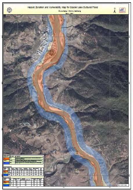
28 Hazard & Vulnerability map
29 Vulnerability Assessment Hazard Level Map Color No. of Buildings No. of People No. of Livestock Historical Monuments No. of Bridges Road Length (Km) Area (Km²) High Red Medium Yellow Low Blue Hazard Level Map Color Cultivated Land (Km²) Arid Land (Barren, Open, Scrubs) (Km²) Forest Cover (Km²) Built Up Area (Km²) High Red Medium Yellow Low Blue
30 Vulnerability Assessment Hazard Level Map Color No. of Buildings No. of People No. of Livestock Historical Monuments No. of Bridges Road Length (Km) High Red Medium Yellow Low Blue
31 Project Frame Work Quick Bird Image Existing Data Field Data Data Collections Data Processing GIS - Database GLOF Hazard Analysis Subjective Analysis Multi-Criteria Evaluation High hazard Hazard Overlay Hazard Map Verification Final Hazard map Vulnerability Assessment

32 THANK YOU & TASHI DELEK Consequence of global warming
DISASTER HAZARDS IN BHUTAN By Tshewang Rinzin January Reducing Disaster Risks for a Safe and Happy Bhutan
 DISASTER HAZARDS IN BHUTAN By Tshewang Rinzin 26-27 January 2009 Reducing Disaster Risks for a Safe and Happy Bhutan Disaster Hazards in Bhutan Earthquakes Glacial Lake Outburst Flood (GLOF) Floods in
Bhutan Country Report for JPTM 2010 (July, 2010) Department of Disaster Management Ministry of Home & Cultural Affairs Royal Government of Bhutan
 Department of Disaster Management Ministry of Home & Cultural Affairs Royal Government of Bhutan") Bhutan Country Report for JPTM 2010 (July, 2010) Department of Disaster Management Ministry of Home & Cultural Affairs Royal Government of Bhutan 1 Contents of Presentation 1. Disaster Hazards and Underlying
Bhutan Country Report for JPTM 2010 (July, 2010) Department of Disaster Management Ministry of Home & Cultural Affairs Royal Government of Bhutan 1 Contents of Presentation 1. Disaster Hazards and Underlying
Disaster Management in Bhutan
 ROYAL GOVERNMENT OF BHUTAN Disaster Management in Bhutan Tshering Wangchuk ROYAL GOVERNMENT OF BHUTAN EARTH FIRE WATER AIR ROYAL GOVERNMENT OF BHUTAN Presentation Outline Various Hazards in Bhutan Major
Disaster RISK Management : Bhutanese Scenario
 Disaster RISK Management : Bhutanese Scenario Expert Group Meeting (EGM) on Geo-referenced Information Systems for Disaster Risk Management (Geo-DRM) and sustaining the Community of Practice (COP), Bangkok,
Geo-information and Disaster Risk Reduction in the Hindu Kush-Himalayan region
 Geo-information and Disaster Risk Reduction in the Hindu Kush-Himalayan region Basanta Shrestha, Division Head MENRIS, International Centre for Integrated Mountain Development Kathmandu, Nepal The International
Glaciers and climate change Jon Ove Hagen, Department of Geosciences University of Oslo
 Glaciers and climate change Jon Ove Hagen, Department of Geosciences University of Oslo joh@geo.uio.no Department of geosciences, Faculty of Mathematics and Natural Sciences Glaciers and climate change
Role of Hydro-Met Services in Disaster Risk Management
 Role of Hydro-Met Services in Disaster Risk Management Tshewang Rigzin (Mr) National Centre for Hydrology and Meteorology, Bhutan 30 th November 2017 Outline Vision and Mission Functions related to Disaster
Data challenges in Trans-boundary River Basins: Case Study of the Upper Indus Basin
 Data challenges in Trans-boundary River Basins: Case Study of the Upper Indus Basin Asif Khan Lead Author (Water chapter- AR6 IPCC) Post Doctorate (Water-Energy-Food-Climate Change, IIASA, Austria) PhD
Report on Disaster statistics of Nepal
 Report on Disaster statistics of Nepal Submitted by Altaf Rehman Submitted to Dr. Naveed Ahmed University of engineering and technology Peshawar Assignment 1 Section A Registration id 14PWCIV456 Page 1
Climate Changes and Natural Hazards in Mountain Areas, Mountainhazards 2011 Dushanbe, Tajikistan
 Climate Changes and Natural Hazards in Mountain Areas, Mountainhazards 2011 Dushanbe, Tajikistan Title: GLOF Risk Assessment in Hindu Kush-Himalayas (HKH) Region in the Era of Climate Change Ashutosh Mohanty
Skeletal remains of what was a debris-covered glacier near Mt. Everest
 Annual satellite imaging of the world s glaciers Assessment of glacier extent and change GLIMS Development and population of a digital glacier data inventory HIGH ICE Skeletal remains of what was a debris-covered
BHUTAN. Reducing Disaster Risks for a safe and Happy. Samdrup Dorji, Survey Engineer Cadastral Information Division National Land Commission, BHUTAN
 NATIONAL LAND COMMISSION BHUTAN Reducing Disaster Risks for a safe and Happy Bhutan Samdrup Dorji, Survey Engineer Cadastral Information Division National Land Commission, BHUTAN Presentation Outline Introduction
Geographic Information Infrastructure and Policy Framework for Sustainable Mountain Development in the Hindu Kush-Himalayas
 Geo SMART ASIA 2017 22-24 August, Kualalampur Geographic Information Infrastructure and Policy Framework for Sustainable Mountain Development in the Hindu Kush-Himalayas Basanta Shrestha, Director Strategic
How to manage risk through integrated geohazard assessment. Prof. John M. Reynolds Reynolds International Ltd, Mold, UK
 How to manage risk through integrated geohazard assessment Prof. John M. Reynolds Reynolds International Ltd, Mold, UK Talk outline Introduction Types of disasters within the Himalayas Integrated Geohazard
GIS as a tool in flood management
 GIS for the United Nations and the International Community Conference Panel: GIS and Capacity - How Territorial Planning Benefits from Geospatial Information 3-5 April 2012 Geneva, Switzerland GIS as a
Country Report Nepal Geospatial Data Sharing Initiatives of Survey Department Supporting Disaster Management
 Third JPTM Step 2 for Sentinel Asia 6-8 July, 2010 Manila, The Philippines Country Report Nepal Geospatial Data Sharing Initiatives of Survey Department Supporting Disaster Management Durgendra M Kayastha
They include earthquakes, volcanic eruptions, floods, landslides, and other processes and occurrences. They are included in the broader concept of.
 They include earthquakes, volcanic eruptions, floods, landslides, and other processes and occurrences. They are included in the broader concept of. In general, natural processes are labeled hazardous only
DROUGHT ASSESSMENT USING SATELLITE DERIVED METEOROLOGICAL PARAMETERS AND NDVI IN POTOHAR REGION
 DROUGHT ASSESSMENT USING SATELLITE DERIVED METEOROLOGICAL PARAMETERS AND NDVI IN POTOHAR REGION Researcher: Saad-ul-Haque Supervisor: Dr. Badar Ghauri Department of RS & GISc Institute of Space Technology
Recent extreme weather events in the Nepal Himalayas
 The Extremes ofthe Extremes: Extraordinary Floods (Proceedings of n symposium held al Reykjavik. Iceland. July 2000). lalispubl.no. 271. 2002. 141 Recent extreme weather events in the Nepal Himalayas SURESH
The Impact of Geography in South and East Asia
 The Impact of Geography in South and East Asia Gobi desert, Mongolia Essential Question: How does geography impact the distribution of population throughout South and East Asia? I CAN Explain how geography
Geospatial Technologies for Resources Planning & Management
 Geospatial Technologies for Resources Planning & Management Lal Samarakoon, PhD Director, Geoinformatics Center Asian Institute of Technology, Thailand Content Geoinformatics for SDG Information Integration
ICIMOD Responding to Mountain Challenges in the Hindu Kush- Himalayas
 ICIMOD Responding to Mountain Challenges in the Hindu Kush- Himalayas Eklabya Sharma International Centre for Integrated Mountain Development Kathmandu, Nepal Regional Intergovernmental Learning and Knowledge
Dealing with climate-change impacts on glacier and permafrost hazards: adaptation strategies in mountain regions
 Dealing with climate-change impacts on glacier and permafrost hazards: adaptation strategies in mountain regions Christian Huggel Luzia Fischer, Wilfried Haeberli, Stephan Gruber, Jeannette Nötzli Glaciology
GLACIAL LAKE OUTBURST FLOODS IN THE NEPAL HIMALAYA JONATHAN M LALA UNIVERSITY OF TEXAS AT AUSTIN CE 394K.3 GIS IN WATER RESOURCES DECEMBER 2, 2016
 GLACIAL LAKE OUTBURST FLOODS IN THE NEPAL HIMALAYA JONATHAN M LALA UNIVERSITY OF TEXAS AT AUSTIN CE 394K.3 GIS IN WATER RESOURCES DECEMBER 2, 2016 TABLE OF CONTENTS Abstract... 3 Introduction... 3 Methods...
investment decisions
 Climate modelling: A guide to investment decisions Vicky Pope Met Office Hadley Centre This is not an ADB material. The views expressed in this document are the views of the author/s and/or their organizations
Report. Developing a course component on disaster management
 Report Developing a course component on disaster management By Chira Prangkio Tawee Chaipimonplin Department of Geography, Faculty of Social Sciences, Chiang Mai University Thailand Presented at Indian
Assessing Climate Change Vulnerability of Cultural Resources
 National Park Service U.S. Department of the Interior Klondike Gold Rush National Historical Park Assessing Climate Change Vulnerability of Cultural Resources Cultural Resources Caitlin Rankin, YLCC Climate
Grant 0299-NEP: Water Resources Project Preparatory Facility
 Document Produced under Grant Project Number: 45206 May 2016 Grant 0299-NEP: Water Resources Project Preparatory Facility Final Report Volume 3 East Rapti (1 of 9) Prepared by Pvt. Ltd. For Ministry of
Climate change and adaptation of the aviation community
 Climate change and adaptation of the aviation community Sigrún Karlsdóttir, Halldór Björnsson, Trausti Jónsson Icelandic Meteorological Office International Air Safety & Climate Change conference EASA
Capacity Building in Applications of Remote Sensing and GIS for Disaster Management
 Capacity Building in Applications of Remote Sensing and GIS for Disaster Management M.K. Hazarika, L. Samarakoon, N. Senevirathne, J.S.M. Fowze and R. de Silva Project Researcher GeoInformatics Center
Chapter 4 Hydrodynamic Modelling of Glacial Lake Outburst Floods
 Chapter 4 Hydrodynamic Modelling of Glacial Lake Outburst Floods To better understand the impacts that a GLOF can have on the downstream valleys, an attempt was made to simulate one GLOF event each in
UNIT 11 SOUTH ASIA SG 1 - PHYSICAL GEOGRAPHY & THE ENVIRONMENT
 UNIT 11 SOUTH ASIA SG 1 - PHYSICAL GEOGRAPHY & THE ENVIRONMENT I. PHYSICAL GEOGRAPHY TAKE OUT YOUR PHYSICAL MAP OF SOUTH ASIA A. The Himalayan Mountains form the northern boundary of the region (color
APPLICATION OF REMOTE SENSING & GIS ON LANDSLIDE HAZARD ZONE IDENTIFICATION & MANAGEMENT
 APPLICATION OF REMOTE SENSING & GIS ON LANDSLIDE HAZARD ZONE IDENTIFICATION & MANAGEMENT PRESENTED BY SUPRITI PRAMANIK M.TECH IN ENVIRONMENTAL SCIENCE AND TECHNOLOGY NIT,DURGAPUR 25-04-2015 1 INTRODUCTION
Progress Report. Flood Hazard Mapping in Thailand
 Progress Report Flood Hazard Mapping in Thailand Prepared By: Mr. PAITOON NAKTAE Chief of Safety Standard sub-beuro Disaster Prevention beuro Department of Disaster Prevention and Mitigation THAILAND E-mail:
1. INTRODUCTION. EXAMPLE OF SECHILIENNE ROCKFALL (France)
") FORM OSE POST-GRADUATE COURSE Landslide vulnerability and risk 1 FORM OSE POST-GRADUATE COURSE Landslide vulnerability and risk 2 FORM OSE POST-GRADUATE COURSE Landslide vulnerability and risk 3 Christophe
FORM OSE POST-GRADUATE COURSE Landslide vulnerability and risk 1 FORM OSE POST-GRADUATE COURSE Landslide vulnerability and risk 2 FORM OSE POST-GRADUATE COURSE Landslide vulnerability and risk 3 Christophe
Coping with International Water Conflict in Central Asia ~ Implications of Climate Change and Melting Ice in the Syr Darya Catchment *
 Coping with International Water Conflict in Central Asia ~ Implications of Climate Change and Melting Ice in the Syr Darya Catchment * *: Partially funded by NOAA CORC ARCHES. Tobias Siegfried, Thomas
GEOSPATIAL ANALYSIS OF GLACIAL DYNAMICS OF SHIGAR AND SHAYOK BASINS. Syed Naseem Abbas Gilany 1
 GEOSPATIAL ANALYSIS OF GLACIAL DYNAMICS OF SHIGAR AND SHAYOK BASINS 1 OUTLINE Introduction Problem Statement / Rationale Objectives Material and Methods Study Area Datasets Required Data Analysis / Assessment
Using Weather and Climate Information for Landslide Prevention and Mitigation
 Using Weather and Climate Information for Landslide Prevention and Mitigation Professor Roy C. Sidle Disaster Prevention Research Institute Kyoto University, Japan International Workshop on Climate and
Natural Disaster Preparedness for Hydropower Projects in High Mountain Environments
 Natural Disaster Preparedness for Hydropower Projects in High Mountain Environments John M. Reynolds Reynolds International Ltd Suite 2, Broncoed House Broncoed Business Park Wrexham Road Mold Flintshire
Louis-François Guerre, Planet Action Coordinator Copenhagen, December Spot Image 2007
 Louis-François Guerre, Planet Action Coordinator Copenhagen, December 2009 1 Spot Image 2007 Spot Image, Earth Observation and geo-information services Satellite operator, imagery distributor SPOT4 SPOT5
Flood Inundation Mapping under different climate change scenarios in the upper Indus River Basin, Pakistan
 Flood Inundation Mapping under different climate change scenarios in the upper Indus River Basin, Pakistan Sohaib Baig (doctoral student) 16 November 2017 Disaster Prevention Research Institute 1 Kyoto
Roles of NGII in successful disaster management
 The Second UN-GGIM-AP Plenary Meeting Roles of NGII in successful disaster management Republic of Korea Teheran Iran 28 October 2013 Sanghoon Lee, Ph.D. NGII Outline Type of Disasters Occur in Korea Practical
Impact of Climate Change on Riverbank Erosion
 International Journal of Sciences: Basic and Applied Research (IJSBAR) ISSN 2307-4531 http://gssrr.org/index.php?journal=journalofbasicandapplied Impact of Climate Change on Riverbank Erosion Most. Nazneen
The Impact of Geography in South and East Asia
 The Impact of Geography in South and East Asia Gobi desert, Mongolia Essential Question: How does the geography of SE Asia impact trade and the distribution of population throughout the region? (AKS #52a)
Impacts of Climate Change and Water-Related Disaster Reduction Management in the Asia-Pacific Region
 Impacts of Climate Change and Water-Related Disaster Reduction Management in the Asia-Pacific Region Katumi MUSIAKE Professor, Fukushima University Secretary General, Asia Pacific Association of Hydrology
Future Climate Change
 Future Climate Change How do you know whether to trust a prediction about the future? All predictions are based on global circulation models (GCMs, AOGCMs) - model accuracy is verified by its ability to
Arctic Adaptation Research Considerations and Challenges
 Arctic Adaptation Research Considerations and Challenges Dr Grete K. Hovelsrud, Research Director CICERO- Center for International Climate and Environmental Research Oslo, Norway Many Strong Voices Stakeholder
*X208/11/01* X208/11/01 GEOGRAPHY INTERMEDIATE 2 NATIONAL QUALIFICATIONS 2014 THURSDAY, 29 MAY 9.00 AM AM
 X208/11/01 NATIONAL QUALIFICATIONS 2014 THURSDAY, 29 MAY 9.00 AM 11.00 AM GEOGRAPHY INTERMEDIATE 2 Candidates should answer four questions: Section A Question 1 and Question 2 AND Section B any two questions
Physical Geography: Patterns, Processes, and Interactions, Grade 11, University/College Expectations
 Geographic Foundations: Space and Systems SSV.01 explain major theories of the origin and internal structure of the earth; Page 1 SSV.02 demonstrate an understanding of the principal features of the earth
Interpretive Map Series 24
 Oregon Department of Geology and Mineral Industries Interpretive Map Series 24 Geologic Hazards, and Hazard Maps, and Future Damage Estimates for Six Counties in the Mid/Southern Willamette Valley Including
Climate Change Impacts in Alaska: the Weather Perspective
 Climate Change Impacts in Alaska: the Weather Perspective September 18, 2007 NOAA s National Weather Service, Alaska Region James Partain, Chief Environmental and Scientific Services Division NOAA NWS
Prediction of Climate Change Impacts in Tanzania using Mathematical Models: The Case of Dar es Salaam City
 Prediction of Climate Change Impacts in Tanzania using Mathematical Models: The Case of Dar es Salaam City By Guido Uhinga PhD Student (Climate Change) Ardhi University Local Climate Solutions for Africa
Journey of supporting CSNs to establish Geo-DRM
 Regional Workshop on Geo-referenced Information Systems for Disaster Risk Management (Geo-DRM) 26-27 June 2014 Bangkok, Thailand Journey of supporting CSNs to establish Geo-DRM Keran Wang Chief, Space
5 Regional Capacity for Studying the GLOF Risk
 5 Regional Capacity for Studying the GLOF Risk The four Himalayan countries that were the focus of the inventory project, Bhutan, India, Nepal and Pakistan, have a range of capacities in terms of the remote
Approach of Estimating Tsunami Economic Losses in The. Okinawa Island with Scenario-based of Input-Output Table. and Okinawa Earthquake Sources
 ORIGINAL ARTICLE Approach of Estimating Tsunami Economic Losses in The Okinawa Island with Scenario-based of Input-Output Table and Okinawa Earthquake Sources Kwanchai Pakoksung 1*, Anawat Suppasri 1,
The Hindu Kush-Himalayan (HKH) region
 region") Understanding the Dynamics of Snow and Glaciers in the Hindu Kush-Himalayan Region Deo Raj Gurung, Remote Sensing Specialist, MENRIS, ICIMOD, drgurung@icimod.org Samjwal Ratna Bajracharya, Remote Sensing
Understanding the Dynamics of Snow and Glaciers in the Hindu Kush-Himalayan Region Deo Raj Gurung, Remote Sensing Specialist, MENRIS, ICIMOD, drgurung@icimod.org Samjwal Ratna Bajracharya, Remote Sensing
USING 3D GIS TO ASSESS ENVIRONMENTAL FLOOD HAZARDS IN MINA
 King Fahd University of Petroleum & Minerals College of Environmental Design Geographical Information system USING 3D GIS TO ASSESS ENVIRONMENTAL FLOOD HAZARDS IN MINA Prepared by : Ali AL-Zahrani OUTLINE
Disaster Risk Assessment: Opportunities for GIS and data management with Open DRI
 Disaster Risk Assessment: Opportunities for GIS and data management with Open DRI Jacob Opadeyi Department of Geomatics Engineering and Land Management, The University of the West Indies, St. Augustine,
MultiHazard Process Chains: Nepal and other hotspots
 MultiHazard Process Chains: Nepal and other hotspots Jeffrey S. Kargel (Thanks to NASA Disasters program and David Green for support) 6 Sep 2016 Glaciers Glacial Lakes Seismicity Meteorological floods
Chapter 27. Bhutan, Maldives, Nepal, & Sri Lanka
 Chapter 27 Bhutan, Maldives, Nepal, & Sri Lanka Physical Geography of Bhutan, Maldives, Nepal & Sri Lanka Landforms Their locations on the fringe of South Asia means their physical and human geography
Study of Temperature Variation over Nepal and its different topographic regions between 1989 and 2010
 Study of Temperature Variation over Nepal and its different topographic regions between 1989 and 2010 By SHRESTHA SAHAJ 51210647 Supervisor: Professor Dr. SANGA-NGOIE Kazadi A Thesis Submitted In Partial
Neeraj Kaushal 1, Kamal Kumar 2 Water Resources Department, PEC University of Technology, Chandigarh, India. IJRASET 2013: All Rights are Reserved
 Time Series Analysis of Glacial Lake in Western Himalayas Based on NDWI and MNDWI Neeraj Kaushal 1, Kamal Kumar 2 Water Resources Department, PEC University of Technology, Chandigarh, India Abstract This
TABLE OF CONTENTS LIST OF TABLES. Page
 TABLE OF CONTENTS Page 11.0 EFFECTS OF THE ENVIRONMENT ON THE PROJECT... 11-1 11.1 Weather Conditions... 11-1 11.2 Flooding... 11-2 11.3 Forest Fires... 11-2 11.4 Permafrost and Subsidence Risk... 11-3
Seamless weather and climate for security planning
 Seamless weather and climate for security planning Kirsty Lewis, Principal Climate Change Consultant, Met Office Hadley Centre 28 June 2010 Global Climate Models Mitigation timescale changes could be avoided
Natural Disasters in Member Countries (2002 Summary)
") 4.2 Member Countries and their Disaster Characteristics: Table 5: Natural Disasters in Member Countries (2002 Summary) (Country/Disaster Type/Disaster Characteristics) Data Country DisType Count of TotAff
4.2 Member Countries and their Disaster Characteristics: Table 5: Natural Disasters in Member Countries (2002 Summary) (Country/Disaster Type/Disaster Characteristics) Data Country DisType Count of TotAff
Unit 1: Basics of Geography Test Review
 Name Date Period Unit 1: Basics of Geography Test Review Directions: Reading the following sections and complete the questions, charts, and diagrams. Types of Maps Maps that have a particular theme are
The Impact of Geography in South and East Asia
 The Impact of Geography in South and East Asia Gobi desert, Mongolia Essential Question: How does the geography of SE Asia impact trade and the distribution of population throughout the region? (AKS #52a)
Flood Level Simulation Modeling And Vulnerability Of Slums Along Musiriver, Hyderabad
 International Journal of Humanities and Social Science Invention (IJHSSI) ISSN (Online): 2319 7722, ISSN (Print): 2319 7714 Volume 7 Issue 05 Ver. I May. 2018 PP.51-56 Flood Level Simulation Modeling And
Copernicus Overview. Major Emergency Management Conference Athlone 2017
 Copernicus Overview Major Emergency Management Conference Athlone 2017 Copernicus is a European programme implemented by the European Commission. The services address six thematic areas: land, marine,
Landslide Hazard Assessment Methodologies in Romania
 A Scientific Network for Earthquake, Landslide and Flood Hazard Prevention SciNet NatHazPrev Landslide Hazard Assessment Methodologies in Romania In the literature the terms of susceptibility and landslide
Assessing Hazards and Risk
 Page 1 of 6 EENS 204 Tulane University Natural Disasters Prof. Stephen A. Nelson Assessing Hazards and Risk This page last updated on 07-Jan-2004 As discussed before, natural disasters are produced by
Jim Fox. copyright UNC Asheville's NEMAC
 Decisions and System Thinking Jim Fox November, 2012 1 UNC Asheville s s NEMAC National Environmental Modeling and Analysis Center Applied Research and technology development on integration of environmental
Use of Geospatial data for disaster managements
 Use of Geospatial data for disaster managements Source: http://alertsystemsgroup.com Instructor : Professor Dr. Yuji Murayama Teaching Assistant : Manjula Ranagalage What is GIS? A powerful set of tools
GIS and Remote Sensing Support for Evacuation Analysis
 GIS and Remote Sensing Support for Evacuation Analysis Presented to GIS for Transportation Symposium Rapid City, South Dakota March 28-31, 2004 Demin Xiong Oak Ridge National Laboratory 2360 Cherahala
CLIMATE CHANGE ASSESSMENT. A. Climate Change Risk Assessment and Adaptation Measures
 Solar Transmission Sector Project (RRP IND 49214) CLIMATE CHANGE ASSESSMENT I. Transmission System at Bhadla, Rajasthan A. Climate Change Risk Assessment and Adaptation Measures High temperature Risk is
Understanding Karnali River Basin. Kabi Raj Khatiwada
 Understanding Karnali River Basin Kabi Raj Khatiwada http://treasuresfromtheroad.com/karnali-river-too-slow-boat/ The asymmetric, single-tower, cable-stayed bridge is the longest of its type in the world
MULTI-HAZARD RISK ASSESSMENT AND DECISION MAKING
 MULTI-HAZARD RISK ASSESSMENT AND DECISION MAKING JULINDA KEÇI Epoka University Logo of the institution CONTENT: Introduction Multi Hazard Risks Multi-Hazard Risk Assessment Quantitative Assessment Event
Considerations on debris-flow hazard analysis, risk assessment and management.
 European Geosciences Union General Assembly 2008, 14-18 April, Vienna Considerations on debris-flow hazard analysis, risk assessment and management. A. Remaître 1, J.-P. Malet 1, O. Maquaire 2 1. CNRS
Existing GIS Resources on the Indus Basin
 Existing GIS Resources on the Indus Basin Workshop on Spatial Information Analysis for the Sustainable Management of the Indus Basin in Pakistan May 26-27, 2003 Elements of Existing GIS Resources Data
Seasonal and annual variation of Temperature and Precipitation in Phuntsholing
 easonal and annual variation of Temperature and Precipitation in Phuntsholing Leki Dorji Department of Civil Engineering, College of cience and Technology, Royal University of Bhutan. Bhutan Abstract Bhutan
South Asia Flash Flood Guidance System Operational Workshop (Step-4)
") South Asia Flash Flood Guidance System Operational Workshop (Step-4) (5 th to 7 th June 2018) Operational Flash Flood Forecasting and Early Warnings Capabilities in Bhutan (Sonam Tashi) Weather Forecaster
South Asia Flash Flood Guidance System Operational Workshop (Step-4) (5 th to 7 th June 2018) Operational Flash Flood Forecasting and Early Warnings Capabilities in Bhutan (Sonam Tashi) Weather Forecaster
International Symposium on Natural Disaster Mitigation. Local vulnerability assessment of landslides and debris flows
 International Symposium on Natural Disaster Mitigation of landslides and debris flows Lessons learnt from Cam Pha town and Van Don district, Quang Ninh province, Vietnam Nguyen Quoc Phi Faculty of Environment
Climate change in Central Asia:Tienshan trends and future
 Climate change in Central Asia:Tienshan trends and future Ysmail Dairov, Regional Mountain Centre of Central Asia 23 October 2012, Eger, Hungary 1 The Regional Mountain Centre of Central Asia was established
Understanding Weather and Climate Risk. Matthew Perry Sharing an Uncertain World Conference The Geological Society, 13 July 2017
 Understanding Weather and Climate Risk Matthew Perry Sharing an Uncertain World Conference The Geological Society, 13 July 2017 What is risk in a weather and climate context? Hazard: something with the
National Adaptation Geo-information System (NAGiS) project in Hungary
 project in Hungary") National Adaptation Geo-information System (NAGiS) project in Hungary Mr. Péter Kajner Hungarian Mining and Geological Survey (MBFSZ) National Adaptation Center Department CGE webinar: Geo-information
National Adaptation Geo-information System (NAGiS) project in Hungary Mr. Péter Kajner Hungarian Mining and Geological Survey (MBFSZ) National Adaptation Center Department CGE webinar: Geo-information
Integration of Geo spatial and Statistical Information: The Nepelese Experience
 Integration of Geo spatial and Statistical Information: The Nepelese Experience Krishna Raj B.C. Joint Secretary Ministry of Land Reform and Management, Nepal 11 June, 2014 Presentation Outline The Country
Spatial Analysis of Natural Hazard and Climate Change Risks in Peri-Urban Expansion Areas of Dakar, Senegal
 1 Spatial Analysis of Natural Hazard and Climate Change Risks in Peri-Urban Expansion Areas of Dakar, Senegal URBAN WEEK 2009 BBL Preston Lounge Thursday, March 12, 2009 Christian Hoffmann GeoVille group
Cambridge International Examinations Cambridge International General Certificate of Secondary Education
 Cambridge International Examinations Cambridge International General Certificate of Secondary Education *7731101867* ENVIRONMENTAL MANAGEMENT 0680/21 Paper 2 October/November 2014 1 hour 45 minutes Candidates
Remote sensing and GIS for multi-hazard risk assessments in the coastal zone: recent applications and challenges in the Pacific Jens Kruger
 Remote sensing and GIS for multi-hazard risk assessments in the coastal zone: recent applications and challenges in the Pacific Jens Kruger Geoscience Division Pacific Community (SPC) The First Pacific
Sea Level Rise and Coastal Inundation Thursday 11 th October, 2012, 1.00pm, With lunch in the Legislative Council Committee Room
 The Presiding Officers invite Parliamentarians and Staff to a Science Briefing on Sea Level Rise and Coastal Inundation Thursday 11 th October, 2012, 1.00pm, With lunch in the Legislative Council Committee
Chapter 27. Bhutan, Maldives, Nepal, & Sri Lanka
 Chapter 27 Bhutan, Maldives, Nepal, & Sri Lanka Physical Geography of Bhutan, Maldives, Nepal & Sri Lanka Landforms Their locations on the fringe of South Asia means their physical and human geography
From Climate Science to Climate Services
 Making sense of complexity in an interdependent world: February 2013 From Climate Science to Climate Services Julia Slingo, Met Office Chief Scientist Climate Change: Taking the planet into uncharted territory?
Introduction to Mountain Regions
 2 Introduction to Mountain Regions 2.1 Populations in Mountain Regions As shown in Table 1, in 2000, the number of people living in mountainous regions was estimated to be more than 1.1 billion, with nearly
Challenges and Potentials of Place Based Information Management in Nepal"
 Nineteenth United Nations Regional Cartographic Conference for Asia and the Pacific, Bangkok, Thailand, 29 October 1 November 2012 Challenges and Potentials of Place Based Information Management in Nepal"
Virtual Reality Modeling of Landslide for Alerting in Chiang Rai Area Banphot Nobaew 1 and Worasak Reangsirarak 2
 Virtual Reality Modeling of Landslide for Alerting in Chiang Rai Area Banphot Nobaew 1 and Worasak Reangsirarak 2 1 Banphot Nobaew MFU, Chiang Rai, Thailand 2 Worasak Reangsirarak MFU, Chiang Rai, Thailand
Earthquake hazards. Aims 1. To know how hazards are classified 2. To be able to explain how the hazards occur 3. To be able to rank order hazards
 Earthquake hazards Aims 1. To know how hazards are classified 2. To be able to explain how the hazards occur 3. To be able to rank order hazards Types of hazard Primary A direct result of the earthquake
Trip Distribution Model for Flood Disaster Evacuation Operation
 Trip Distribution Model for Flood Disaster Evacuation Operation The devastating consequences of disasters in both developed and developing countries indicate significant lack or absence of disaster management
Drought lesson plan ITEMS. Teachers lesson plan. Student assignments. About droughts. Real life stories. Droughts: Be prepared.
 Drought lesson plan The drought lesson plan provides teachers and students with an opportunity to investigate the Australian climate, water table and the impacts of drought through individual or classroom
Vulnerability of Bangladesh to Cyclones in a Changing Climate
 Vulnerability of Bangladesh to Cyclones in a Changing Climate Susmita Dasgupta Kiran Pandey Mainul Huq Zahirul Huq Khan M.M. Zahid Ahmed Nandan Mukherjee Malik Fida Khan 2010 Bangladesh: Tropical Cyclone
Ice Sheets and Sea Level -- Concerns at the Coast (Teachers Guide)
") Ice Sheets and Sea Level -- Concerns at the Coast (Teachers Guide) Roughly 153 million Americans (~53% of the US population) live in coastal counties. World wide some 3 billion people live within 200 km
Ice Sheets and Sea Level -- Concerns at the Coast (Teachers Guide) Roughly 153 million Americans (~53% of the US population) live in coastal counties. World wide some 3 billion people live within 200 km