INDIAN GEOGRAPHY ADITYA IAS ACADEMY India Location & Size. Location
|
|
|
- Emily Flynn
- 5 years ago
- Views:
Transcription
 divides the country into almost two equal parts.")
1 ADITYA IAS ACADEMY INDIAN GEOGRAPHY 1. India Location & Size Location India lies entirely in the Northern Hemisphere. The mainland extends between - 8degree 4 N and 37degree 6 N latitude 68degree 7 E and 97degree 25 E longitude Tropic of Cancer (23degree 30 ) divides the country into almost two equal parts. The latitudinal and longitudinal extent of India is about 30degree, which causes a time difference of nearly 2 hrs between the easternmost and westernmost parts of the country. The mainland of India extends from Kashmir in the north to Kanyakumari in the south Arunachal Pradesh in the east to Gujarat in the west The northern part of the country lies in the sub-tropical zone or the warm temperate zone while the southern part lies within the tropics. The east-west extent (2933 km) appears to be smaller than the north-south extent (3214 km). Time along the Standard Meridian of India i.e. 82degree 30 E (which is ahead of GMT by 5 hrs 30 min) passing through Mirzapur (UP) is taken as the Standard Time for the country. India is a southward extension of the Asian continent. No other country has a long coastline on the Indian Ocean as India has and indeed it is India s eminent position in the Indian Ocean which justifies the naming of an ocean after it. This has provided the country with a coastline of 6500 km in the mainland 7517 km in the entire mainland plus island groups The southernmost point of the Indian Union- Indira Point got submerged under the sea-water in 2004 during the Tsunami. Gujarat has longest coastline followed by Andhra Pradesh, Tamil Nadu and Maharashtra respectively. Size India has an area of 3.28 million sq. km. Its total area accounts for about 2.4% the total geographical area of the world. India is 7th largest country in the world. Russia>Canada>USA>China>Brazil>Australia>India 1


2 India is bounded by young fold mountains in North-east - Hindukush and Sulaiman Ranges North - Himalayas North-east - Purvanchal Hills Indian subcontinent includes India, Pakistan, Nepal, Bhutan and Bangladesh. India s territorial limit extends towards the sea up to 12 nautical miles from the coast. 1 nautical mile = about 1.8 km 2

3 India s Neighbor India occupies an important strategic position in South Asia. North-west - Pakistan and Afghanistan North - China, Nepal and Bhutan East - Bangladesh and Myanmar Our southern neighbors across the sea consist of two island countries-sri Lanka and Maldives. Sri Lanka is separated from India by a narrow channel formed by the Palk Strait and Gulf of Mannar. Bangladesh shares the largest land frontier with India followed by China and Pakistan respectively. Tropic of Cancer passes through Gujarat, Rajasthan, Madhya Pradesh, Chhattisgarh, Jharkhand, Tripura and Mizoram. The capitals of these 3 states lie above Tropic of Cancer Rajasthan, Tripura and Mizoram. Standard Meridian of India passes through Uttar Pradesh, Madhya Pradesh, Chhattisgarh, Odisha and Andhra Pradesh. 3

4 Q 1) which of the following pairs of islands is separated from each other by Ten Degree Channel? a. Andaman and Nicobar b. Nicobar and Sumatra c. Maldives and Lakshadweep d.sumatra and Java Ans.- a 4
5 Q 2) If you travel by road from Kohima to Kottayam, what is the minimum no. of states within India through which you can travel, including the origin and destination? a.6 b.7 c.8 d.9 Ans. -b (Nagaland, Assam, W.B., Odisha, Andhra Pradesh, Karnataka or Tamil Nadu and Kerala) Q 3) among the following cities, which one lies on a longitude closest to that of Delhi? a. Bengaluru b. Hyderabad c. Nagpur d. Pune Ans. A (Delhi and Bengaluru are located almost on the same latitude) 5
6 2. STRUCTURE AND PHYSIOGRAPHY Structure The geological structure of a country helps in understanding the types and character of rocks and slopes, the physical and chemical properties of soils, the availability of minerals, and the surface and underground water resources. Geological Time Scale - It is a record of Earth s Geologic history based on radiometric dating and the record of ancient life preserved in layers of rocks. Era Period (million years ago ) Epoch Quaternary Holocene (.01) Pleistocene (1.8) Pliocene (5.3) Cenozoic Miocene (23.8) Tertiary Oligocene (33.7) Eocene (54.8) Paleocene (65.0) Cretaceous (144) Jurassic (206) Plant and Animal Development Humans develop "Age of mammals" Extinction of dinosaurs and many other species. First flowering plants Mesozoic "Age of Reptiles" First birds Triassic (248) Dinosaurs dominant. Permian (290) Carboniferous: Pennsylvanian (323) Extinction of trilobites and many other marine animals Paleozoic Carboniferous: Mississippian (354) "Age of Amphibians" First reptiles Large coal swamps Large Amphibians abundant. Devonian (417) "Age of Fishes" First insect fossils 6
7 Silurian (443) Fishes dominant First land plants Ordovician (490) First fishes Cambrian (540) "Age of Invertebrates" Trilobites dominant First organisms with shells First multicelled organisms Precambrian - comprises about 88% of geologic time (4500) First one-celled organisms Origin of Earth 1. Pre-Cambrian Era - Collision between 3 proto continents and so developed 3 lineaments. Aravalli - Narmada Singhbhum - Son Dharwad - Godavari Geosynclines developed at margin of these proto continents Aravalli, Vindhyan, Satpura, Eastern Ghats, Bijawal ( Chotanagpur Plateau) 2. Gondwana times Reactivation of 3 lineaments Rifting of Mahanadi and Damodar Submergence of forest development of coalfields 3. Mesozoic Time Indian plate broke from Gondwana land and started northward journey (150 million yrs ago) - Gondwana land is the southern part of the ancient super continent Pangaea with Angara land in the northern part. 7
8 NOTE Gondwana land include India, Australia, South Africa, South America and Antarctica as one single land mass. India plate broke from Madagascar (15 million years ago) 4. Late Cretaceous India moved over Reunion Islands which are having hotspot volcanism. So Deccan lava plateau was formed. 5. Tertiary Time Indian plate collided with Eurasian plate and hence Himalaya was formed. 6. Late Pleistocene Northern plain was formed. Physiography Physiography deals with the study of the surface features and landforms of the earth. Geological divisions of India 1. Peninsular Block It is composed of igneous and metamorphic rocks with gently rising hills and wide valley. It is most stable land blocks & ancient landmasses on the earth s surface. 2. Himalayas Himalayan Mountains form an unstable zone. 3. Indo-Ganga-Brahmaputra plain These are formed of alluvial deposits. Major Physiographic Divisions 1. Himalayan Mountains 2. Northern Plains 3. Peninsular Plateau 4. Indian Desert 5. Coastal Plains 6. Islands Himalayan Mountains It is geologically young and structurally fold mountains. It represents the loftiest and one of the most rugged mountain barriers of the world. Their width varies from 400 km in Kashmir to 150 km in Arunachal Pradesh. The altitudinal variations are greater in the eastern half than those in the western half. 8
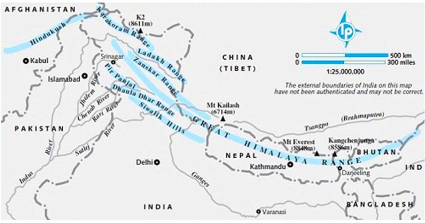
9 Six phases are involved in the formation of Himalayas 1. Tibetan Plateau (not a part of Himalaya but is formed due to Himalayan orogeny) 2. Indus- Tsangpo Suture Zone 3. Tethys Himalaya or Trans-Himalaya (not a part of Himalaya) 4. Great Himalayas MCT (Main Central Thrust) It separates Greater Himalaya from Lesser Himalaya. 5. Lesser Himalayas MBF (Main Boundary Thrust) It separates Lesser Himalaya from Shiwaliks. 6. Shiwaliks HFF (Himalayan Front Fault) It separates Shiwaliks from the Northern Plains. Western Himalayas It sprawls from Indus to Kali River. The ranges from north to south are Karakoram, Ladakkh, Zaskar, Pir Panjal and Dhauladhar. The slopes are lower and gradual. The peaks are K2, Godwin Austin, Gasherbrum, Masherbrum. They don t act as barrier for north-west monsoon. Eastern Himalayas It sprawls from Kali to Brahmaputra River. The hill from north to south are Mishmi, Abor, Miri and Dafla (Mnemonics MAMD) The slopes are steep and higher. The peaks are Everest, Makalu, Annapurna and Dhaulagiri. They act as active barrier to south-west monsoon. Eastern Himalayas get more rainfall than western Himalayas. 9
10 10
11 Physiographic Divisions of Himalayas 1. The Trans-Himalayas 2. The Greater Himalayas (Himadri) 3. The Lesser Himalayas (Himachal) 4. The Shiwaliks The Trans-Himalayas Most of them lie in Tibet. They contain the Tethys sediments. It constitutes the core of the Himalayan axis. It consists of ranges like Karakoram (K 2), Ladakh (Rakapokshi). Karakoram region is home of the greatest glaciers of world outside polar region. Some of them are Siachen (highest battlefield), Baltoro (largest mountain glacier), Biafo and Hispar glacier. It acts as watershed between India and Turkmenistan. The Great Himalayas- It is the most continuous range. The core of this part of Himalayas is composed of Granite. It is perennially snow bound and a number of glaciers descend from this range. Some highest peaks of the Himalayas are 1. Mt.Everest or Sagarmatha (Nepal) 2. Kanchenjunga (Sikkim) 3. Nanga Parbat 4. Nanda Devi 5. Kamet 6. Namcha Barwa The Lesser Himalayas The Shiwaliks It lies to the south of the Great Himalayas. Important ranges Pir Panjal (largest range), Dhaula Dhar and Mahabharata range (Nepal). This region is well known for its hill stations like the Kashmir valley, the Kangra and Kullu valley. It consists generally of unfossiliferous sediments or metamorphosed crystalline. The main rocks are slate, limestone and quartzite. This region is subjected to heavy rainfall, deforestation and urbanization. It is locally known as Dhaula Dhar (in H.P.) and Nagtibha (in Uttarakhand) It is the outermost range of the Himalayas. These ranges are mainly composed of sandstone, sand rocks, clay brought down by rivers from the main Himalayan ranges. These valleys are covered with thick gravel and alluvium. NOTE The longitudinal valley lying between lesser Himalaya and the Shiwaliks are known as Duns. E.g. Dehra Dun, Kotli Dun, Patli Dun 11
12 Longitudinal Divisions of the Himalayas 1. The Kashmir Himalayas 2. The Himachal ad Kumaon Himalayas 3. Darjeeling and Sikkim Himalayas 4. The Arunachal Himalayas 5. Eastern Hills and Mountains The Kashmir Himalayas It extends from the Indus to Sutlej river. It comprises a series of ranges north to south (Mnemonics K L Zaskar P D). Karakoram Ladakh Zaskar Pir Panjal Dhaula Dhar The Ladakh region of the Kashmir Himalayas is a cold desert, which lies between the Greater Himalayas and the Karakoram ranges. Between the Great Himalayas and the Pir Panjal lies the famous Dal Lake. Fresh lakes are Dal Lake and Wular Lake. Salt lakes are Pangong Tso and Tso Moriri. It has the largest no. glaciers in India. The important glaciers of South Asia are Baltoro and Siachen. The Kashmir valleys are also famous for Karewa formation which is useful for the cultivation of Zafron, a local variety of Saffron. Karewa are thick deposits of glacial clay and other materials embedded with moraines. Important passes are Zozi La - Great Himalayas (between Kashmir and Ladakh) Banihal - Pir Panjal (Mnemonics B-P) Photu La - Zaskar Khardung La - Ladakh Range (Mnemonics- K-L) Thang La - Ladakh Range The region is drained by the river Indus and its tributaries such as the Jhelum and Chenab. Jhelum in the valley of Kashmir is still in its youth stage ad yet form meanders. The southernmost part of this region consists of longitudinal valleys known as Duns. E.g. Jammu Dun and Pathankot Dun The Himachal and Kumaon Himalayas It extends from Sutlej to Kali River. The northernmost part of the Himachal Himalayas is an extension of the Ladakh cold desert, which lies in the Spiti subdivisions of Lahul & Spiti. All the three ranges (the Greater, the lesser and the Outer Himalayas) are well represented in this region. Important passes are Rohtang, Bara-Lacha, Shipki La (HP) and Lipulekh pass (Uttarakhand). 12
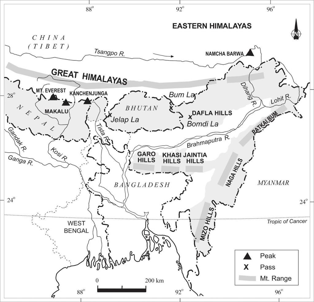
13 It is drained by two major river systems in India the Indus and the Ganga. These valleys are well known for orchards and scenic beauty.shimla, Dalhousie, Chamba, Dharamshala and Kullu-Manali are the important hill stations of this region The two distinguishing features of this region are the Shiwaliks and Dun formation. In the Great Himalayan range, the valleys are mostly inhabited by the Bhotiyas. These are nomadic groups who migrate to Bugyals (the summer grasslands in higher reaches) during summer months and return to the valleys during winter. The Valley of Flowers is situated in this region. The region is also known to have famous five Prayags (river confluences). The Darjeeling & Sikkim Himalayas They are flanked by Nepal Himalayas in the west and the Bhutan Himalayas in the east. It has very few passes Nathu La and Jelep La (tri-junction of India, China and Bhutan). It is a region of high mountain peaks and deep valleys. Some of the peaks are as follow in decreasing order of their height Kanchenjunga, Makalu, Dhaulagiri, Annapurna, Manaslu and Gosainath. The higher reaches of this region are inhabited by Lepcha tribes. Tea plantation is done in this region because of physical conditions such as moderate slope, thick soil cover with high organic content, well distributed rainfall throughout the year and mild winters. As compared to the other three sections of the Himalayas, these along with the Arunachal Himalayas are conspicuous by the presence of Shiwaliks formation. In place of the Shiwaliks, here the Duar formation are important which act as gateways to Himalayas. These are also known for their scenic beauty and rich flora and fauna, particularly various types of orchids. The Arunachal Himalayas It extends from Tista to Dihang River. It has a no. of mountain passes Bomdi La, Bom La and Diphu pass (tri-junction of India, China ad Myanmar). Here most of the interactions are carried through the duar region along the Arunachal-Assam border. The important mountain peaks are Kangtu and Namcha Barwa. These ranges are dissected by fast flowing rivers from the north to the south, forming deep gorges. Brahmaputra flows through a deep gorge after crossing Namcha Barwa. The important rivers are Kameng, Subhansiri, Dibang, Dihang and Lohit. These are perennial with the high rate of fall, thus forming the highest hydro-electric power potential in the country. Some of the prominent ethnic tribal community is from west to east are Monpa, Dafla, Abor, Mishmi, Nishi and Nagas. Most of these communities practice Jhumming or Shifting or Slash & Burn cultivation. 13
14 Eastern Hills and Mountains These are low hills, inhabited by numerous tribal groups practicing Jhum cultivation. Passing through the states of Nagaland, Manipur, Tripura and Mizoram, it is locally known as Purvanchal. These hills are mostly composed of strong sandstones which are sedimentary rocks. The main hills of Purvanchal are Patkai Bum (A.P.), Naga hills (Mt. Saramati), Manipur hills, Mizo or Lushai hills, Blue Mt.(Mizoram), Tripura Range. The main rivers are Barak (Manipur, Mizoram and Assam) and Dhansiri (Nagaland). The Physiography of Manipur is unique by the presence of Loktak Lake at the centre, surrounded by mountains from all sides. Mizoram which is also known as the Molassis Basin is made up of soft unconsolidated deposits. NOTE On the border of Nagaland and Myanmar lies the Arakan Yoma. The extension of this mountain chain continues southward up to the Andaman & Nicobar islands and even up to the Archipelago of Indonesia. Northern Plains The northern plain has been formed by the interplay of the three major river systems Indus, Ganga and Brahmaputra along with their tributaries. This plain is formed of alluvial soil. It lies to the south of the Shiwaliks and separated by the HFF (Himalayan Front Fault). It is a transitional zone between the Himalayas of the north and Peninsular India of the south. Changing river courses in the areas of frequent floods is a unique geomorphic process in the plain. Majuli Island (Assam), in the Brahmaputra River is the largest inhabited riverine island in the world. Physiographic divisions of the Northern Plains north to south Bhabar Plain, Terai Plain, Bhangar Plain and Khadar Plain. 1.Bhabar Plain 2. Terai Plain In width, the Bhabar plain is about 8-16 km, consisting of gravel and unasserted sediments deposited by the rivers descending from the Himalayas and Shiwaliks. All the streams disappear in the Bhabar belt. It is not suitable for cultivation of crops. South of Bhabar belt, the streams and rivers re-emerge and create a wet, swampy and marshy region known as Terai. This is thickly forested region full of wildlife. At present, the Terai region is known for good cultivation of sugarcane, rice, wheat etc. 14
15 3. Bhangar Plain The largest part of the northern plain is formed of older alluvium. It lies above the flood limits of the rivers and present a terrace like features. The soil in this region contains concretions ad nodules of impure calcium carbonate or Kankar. 4. Khadar Plain The newer younger deposits of the flood plains are called Khadar. They are enriched by fresh deposits of silt every year during the rainy season and so are fertile, thus, ideal for intensive agriculture. NOTE Alluvial Plains are subdivided into Bhangar and Khadar. Major Regions of the Northern Plains Based on geo-climate and topographical characteristics The Rajasthan Plains The Punjab Plains The Gangetic Plains The Brahmaputra Plains 1. The Rajasthan Plains - They lie to the west of the Aravalli and include the Marusthali and the Bagar of Rajasthan. At present, Luni is the only flowing river which reaches the Arabian Sea through the marshes of the Rann of Kachchh. North of Luni, there is a large area of inland drainage. The greater part of the Rajasthan Plains is desert covered with longitudinal and transverse sanddunes (called Dhrians) and barchans. A large no. of Playa lakes occur in the basin. The soils are fertile but lack moisture. 2. The Punjab Plains It is an aggradational plain, deposited by the Sutlej, Beas and Ravi rivers. This plain is becoming arid rapidly due to Salinization due to over irrigation. 3. The Gangetic Plains It lies between the Yamuna catchment to Bangladesh border. The Upper Ganga Plain lies between Yamuna to Ghaghara. It includes the Rohillakhand plain. It is the most productive plains of India in which the Green Revolution is a big success. The Middle Ganga Plain includes Kosi plain. It is flood prone areas. It has thick alluvial deposits with less Kankar formation. The Lower Ganga Plain extends from Patna (Bihar) to the Bay of Bengal. It has been formed by the down warping of a part of the Peninsular India between Rajmahal hills and the Meghalaya plateau and subsequent sedimentation by the Ganga and Brahmaputra rivers. In the lower part of it, is Sundarban Delta (largest mangrove swamp in the world). 15
16 4. The Brahmaputra Plains NOTE Rahr Plain is a part of the Lower Gangetic Plain. It lies to the east of the Chotanagpur Plateau. It is drained by Damodar and Subarnarekha rivers. It is covered by the lateritic-alluvial soils. It is a depositional plain. The region is surrounded by high mountains on all sides, except on the west. It is one of the most productive plains of India in which rice and jute are the main crops. Swamps and marshes are numerous in the northern region of the lower Brahmaputra valley. Peninsular Plateau The peninsular plateau is one of the oldest and the most stable landmass of India. It is composed of the old crystalline, igneous and metamorphic rocks. It was formed due to the breaking and drifting of the Gondwana land. It is made up of a series of patland plateaus such as the Hazaribagh plateau, Palamu plateau, Malwa plateau, Coimbatore plateau and the Karnataka plateau. It is known as Ruhr of India due to large mineral deposits. An extension of this is also seen in the northeast in the form of Shillong and Karbi-Anglog Plateau. The western and north-western part of the plateau has an emphatic presence of black soil. It is known as Deccan Trap. This is of volcanic origin hence the rocks are igneous. Some of the important physiographic features of this region are tors, block mountains, rift valleys, bare rocky structure, series of hummocky hills and wall-like quartzite dykes. Peninsular Plateau can be divided into 1. Central Highlands 2. Eastern Plateau 3. Deccan Plateau Central Highlands The part of the Peninsular plateau lying to the north of the Narmada River covering the whole Malwa plateau. 1. North Central Highlands It comprise Aravalli and the Malwa plateau. Aravalli It is one of the oldest fold mountains of the world. It is mainly composed of quartzite, gneisses and schists. Its highest peak is Guru Shikhar. It spreads over Delhi, Haryana, Rajasthan and Gujarat (Palanpur). It is source of these rivers Luni, Banas and Sabarmati. Haldighat is a mountain pass in the Aravalli range of Rajasthan. Malwa Plateau It is bordered by the Aravalli in the north, the Vindhyan Range in the south and the Bundelkhand plateau in the east. 16
17 It is historically known as Khandesh. It is semi-arid region. These regions are facing high soil erosion. It is known as Chambal badlands. It has two drainage systems one towards the Arabian Sea (Narmada and Tapi) and another towards the Bay of Bengal (Chambal, Sind, Betwa and Ken). 2. South Central Highlands The Vindhyan Range extends from Gujarat to Bihar. It spreads over 5 states Gujarat, M.P., Chhattisgarh, U.P. and Bihar. It is source of these rivers Chambal, Sind, Betwa and Ken. Kaimur hills are a part of the Vindhyan range. It spreads over M.P., U.P. and Bihar. It comprises Bundelkhand and Baghelkhand region (M.P. & U.P.) which are drought prone areas. Eastern Plateau 1. Chotanagpur Plateau It spreads over parts of West Bengal, Jharkhand, Chattisgarh, Odisha and northeastern part of Andhra Pradesh. It consists of plateaux at different levels of elevation. These regions are cartons of Singhbhum which are rich in mineral deposits. The rivers which drain the plateau are Barakar, Damodar, Subarnarekha and Koel. Rajmahal hill is in Jharkhand. 2. Meghalaya Plateau It is detached from the Indian Peninsula by the Malda Gap. It consists of Garo, Khasi and Jaintia hills and its outlying include Mikir and Regma hills. The hills are not very high. Kapilli River separates Mikir and Regma hills from the Meghalaya plateau. The Shillong peak is the highest peak. Nokrek is the highest peak of Garo hills. It is not effective in blocking the rain bearing winds but the rain passes with funneling effect so heavy rainfall occur in Meghalaya. They receive maximum rainfall from the south-west monsoon. Mawsynram records the highest rainfall in the world. It has highly eroded surface. Meghalaya plateau is rich in mineral resources like coal, iron-ore, sillimanites, limestone and uranium. Deccan Plateau 1. North Deccan It is mainly covered with basalt. It comprises Satpura Range and Maharashtra plateau. Satpura range spreads over Gujarat, Maharashtra, M.P. and Chhattisgarh. 17
18 Maikal Rnnge forms a connecting link between the Vindhyan and the Satpura Mountains. Maikal range is in Chhattisgarh. The most striking feature is the fault, giving rise to the present shoreline of the Arabian Sea. West to East Rajpipla hills (GJ), Gawilgarh hills (MH), Mahadeo hills (MH) and Maikal hill (CH). It has steep gradient in the north and gentle slope in the south. It also comprises Mahanadi Basin, Chhattisgarh plain, Garhjat hills (Odisha) and Dandakaranya (Chhattisgarh, Odisha and Andhra Pradesh). 2. South Deccan It shows dominance of Archaean and Dharwad formations. Karnataka Plateau Mulangiri is the highest peak in Baba Budan hills in Karnataka. The northern upland is known as Manland while the southern part is called a Maidan. Telangana Plateau It lies between Satmala hills (MH) and Sechachalam hills (Andhra Pradesh). 3. Western Ghats - It spreads over 6 states Gujarat, Maharashtra, Karnataka, Goa, Kerala and Tamil Nadu. Western Ghats are comparatively higher in elevation and more continuous than the Eastern Ghats. It provides natural conditions for the development of ports. Western Ghats are parallel to the western coasts. Most of the Peninsular Rivers have their origin in the Western Ghats. It causes the orographic rain by forcing the rain bearing moist winds to rise along the western slope of the Ghats. The height of the Western Ghats increases from north to south. Its highest peak is Anamudi. The hills in Maharashtra from north to south Ajanta, Satmala, Balaghat and Harischandra. In the Nilgiris, the Eastern Ghats join the Western Ghats to form a mountain knot whose highest point is Anamudi. The important passes of Western Ghats are Thal Ghats between Mumbai and Nasik Bhor Ghats between Mumbai and Pune Pal Ghats joins Coimbatore with Kochi and Kozhikode NOTE The short westward flowing Sharavati River (in Karnataka) forms the highest waterfall of India named Jog Falls. 4. Eastern Ghats It spreads over 5 states West Bengal, Odisha, Andhra Pradesh, Karnataka and Tamil Nadu. They are discontinuous and irregular and dissected by rivers draining into the Bay of Bengal. It is lower than Western Ghats. Jindhagadani is the highest peak in the Eastern Ghats. 18
19 The hills from north to south are Nallamalla hills (AP & Telangana), Venukonda hills (AP), Palkonda hills (AP), Nagari hills (AP), Sechachalam hills (AP), Javadi and Shevroy hills (TN), Panchamalai hills(tn), Sirumalai hills (TN) and Varushnad hills (TN). Southern Hill Complex It lies to the south of the Western Ghats but it is neither a part of Western Ghats nor Eastern Ghats. It includes Nilgiri Hills (KR and TN) Anamalai Hills (KR and TN) Palani Hills (KR and TN) The hill stations in these regions are Ooty - Nilgiri hills Munnar - Anamalai hills Kodaikanal Palani hills NOTE Kodaikanal is artificial lake. Shenkotta Gap is in between Cardamom hills. The Indian Deserts To the north-west of the Aravalli hills lies the Great Indian Deserts. It is a land of undulating topography dotted with longitudinal dunes and barchans (crescent shaped dunes). It receives low rainfall below 150 mm per year. It has arid climate with low vegetation cover. It is because of these characteristics features that this is also known as Marusthali. During the Mesozoic era, this region was under the sea. Some of the well pronounced desert land features present here are mushroom rocks, shifting dunes and oasis (mostly in the southern part). Low precipitation and high evaporation makes it a water deficit region. Most of the river in this region is ephemeral (short-lived). Luni River originates in the Pushkar valley of the Aravalli Range, near Ajmer, passes through the south-eastern portion of the Thar Desert, and ends in the marshy lands of Rann of Kutch in Gujarat. The lakes and playas have brackish water which is the main source of obtaining salt. On the basis of the orientation, the desert can be divided into two parts the northern part is sloping towards Sindh and the southern part towards the Rann of Kutch. The Coastal Plains They were formed by the depositional action of therivers and the erosional and depositional action of the sea-waves. On the basis of the location and active geomorphological process, it can be divided into the western coastal plain and the eastern coastal plain. The Western Coastal Plain It is characterized mainly by sandy beaches, coastal sand-dunes, mud flats, lagoons, alluvial tracts along rivers, estuary, lateritic platforms and residual hills. The western coast may be divided into following divisions 1. Kachchh and Kathiawar Coast in Gujarat 19
20 2. Konkan Coast in Maharashtra (Daman to Marmagao) 3. Goan Coast in Karnataka (Marmagao to Mangalore) 4. Malabar Coast in Kerala (Mangalore to Kanyakumari) The first three are an example of submerged coastal plain. Because of this submergence, it is a narrow belt and provides natural conditions for the development of ports and harbors. The important natural ports are Kandla, JLN Port Navha Sheva, Mazagaon, Marmagao, Mangalore and Cochin. The Malabar Coast shows evidence of emergence. There are numerous shallow lagoons and backwaters Kayals and Teris. Vembanad and Asthamudi are the important lagoons of the Malabar Coast. The western coastal plains are narrow in the middle ad get broader towards north and south. They do not form any delta. They form estuaries. The Eastern Coastal Plains In the northern part, it is referred to as the Northern Circar while the southern part is known as the Coromandel Coast. These are gentle, monotonous plains rising gently westward to the foot of the Eastern Ghats. These plains are wide and level. As compared to the western coastal plain, the eastern coastal plain is broader and is an example of emergent coast. The continental shelf extends up to 500 km into the sea, which makes it difficult for the development of good ports and harbors. There are well developed deltas here. There are some of the important lagoons of India along the eastern coast. 1. Chilika Lake It is the largest salt water lake in India, located in Odisha. 2. Kolleru Lake lies between the deltas of Godavari and Krishna. 3. Pulicat Lake lies further south on the border of Andhra Pradesh & Tamil Nadu. The Islands India has a total of 615 islands, of which 572 lies in the Bay of Bengal and the remaining 43 in the Arabian Sea. The Bay of Bengal Islands include the Andaman & Nicobar Islands which are largely tectonic and volcanic in origin while the islands of the Arabian Sea are coral formations. There are a no. of offshore islands along the mouth of the Ganga, eastern and western coast and in the Gulf of Khambat and Mannar. Many of these islands are inhabited and administered by the adjacent states. The Andaman & Nicobar Islands The entire group of islands are divided into two categories the Andaman in the north and the Nicobar in the south. They are separated by a water body called the Ten Degree Channel. They have a warm tropical climate all year round with two monsoons. These islands receive convectional rainfall and have an equatorial type of vegetation. The entire region falls in a major earthquake zone. The Barren Island in the Andaman has an active volcano. The main rocks of these islands are sandstone, limestone and shale. These are submarine islands. But the Physiography of the Nicobar Island is mainly of coral origin. Some of the tribes of these islands are Onges, Jarawas and Sentinelese. Wandoor Marine Biosphere Reserve is in South Andaman and Great Nicobar Island. The important peaks from north to south are Saddle peak, Mount Diavolo, Mount Koyob and Mount Thuiler (Great Nicobar). Duncan passage lies between South Andaman and Little Andaman. 20
21 The Lakshadweep Islands The islands of the Arabian Sea include Lakshadweep and Minicoy. The entire island group is built of coral deposits. It is closest to the mainland compare to Andaman. Nine Degree Channel seperates Kavaratti from Minicoy Island. Lakshadweep islands are separated from the Maldives Islands by Eight Degree Channel. Minicoy is the largest island. The hills and streams are absent on these islands, Pitti Island which is uninhabited has a bird sanctuary. Fishing is the main occupation of the people of Lakshadweep. Corals Coral Polyps are short-lived microscopic organisms which live in colonies. They flourish in shallow, mud free and warm waters. They secrete calcium carbonate. The coral secretions and their skeletons form coral deposits in the form of reefs. They are mainly of 3 types fringing reef, barrier reef and atolls. Great Barrier Reef of Australia is a good example. Atolls are circular or horse shoe shaped coral reefs. 21
22 3. Drainage System Drainage The term drainage describes the river system of an area. The area drained by a single river system is called a drainage basin. The world s largest drainage basin is of the Amazon River. Water Divide is any elevated area such as the mountain or an upland which seperates the drainage basins. A catchment area is an area of land where all surface water from rain, melting snow or ice converges to a single point at a lower elevation, usually the exit of the basin. A watershed describes an area of land that contains a common set of streams and rivers that all drain into a single larger body of water, such as the large river, a lake or an ocean. The micro unit within a river basin is known as the watershed while the sum of all the micro, meso and macro tributaries of a river is known as a river basin. Watersheds are small in areas while the basins cover large areas. Drainage Pattern The factors controlling the pattern of drainage in a region include the topography, slope, structural control, and nature of rocks, tectonic activities, supply of water, and above all, the geological history of that region. The important drainage patterns are 1. Dendritic Pattern It develops where the river channel follow the slope of the terrain. The streams with its tributaries resembles the branches of a tree so the name Dendritic. Most of the rivers of the Gangetic Plains are of Dendritic type. 2. Trellis Pattern A river joined by its tributaries, as approximately right angles, develops a trellis pattern. It develops where hard and soft rocks exit parallel to each other. The old folded mountains of Chotanagpur Plateau have trellis pattern, 3. Rectangular or Centripetal Pattern It is a drainage pattern in which the main streams and their tributaries display many right-angle bends and exhibit sections of approx the same length. It differs from trellis pattern as it is more irregular and its tributary streams are neither long nor parallel as in trellis pattern. It is found in Vindhyan Mountains. 4. Radial Pattern It develops when streams flow in different directions from a central peak or dome like structure. A good example is those rivers which originate from the Amarkantak Plateau. Drainage Systems in India The drainage systems of India are mainly controlled by the broad relief features of the subcontinent. India has 113 river basins, of which, 14 are large, 44 medium and 55 minor river basins. On the basis of discharge of water, it may be divided into the Arabian Sea drainage and the Bay of Bengal drainage. 22
23 They are separated from each other through the Delhi Ridge, the Aravalli and the Sahyadris. Nearly 75% of the drainage area is oriented towards the Bay of Bengal while 25% discharge their water in the Arabian Sea. On the basis of mode of origin, nature and characteristics, Indian rivers are divided into two main groups 1. Himalayan Rivers Most of the Himalayan Rivers are perennial. It means that they have water throught the year. It comprises the Indus, the Ganga and the Brahmaputra. They have cut through the mountains making gorges. They perform intensive erosional activity in their upper courses and carry huge loads of silt and sand. In the middle and the lower courses, these rivers form meanders, ox bow lakes and many other depositional features in their floodplains. The great Himalayan Rivers (Indus, Sutlej, Kali, Karnali, Gandak, Kosi, Tista and Brahmaputra) are antecedent rivers. 2. The Peninsular River A large no. of the peninsular rivers is seasonal, as their flow is dependent on rainfall. They have shorter and shallower courses as compared to the Himalayan counterparts. Most of the rivers of Peninsular India originate in Western Ghats and flow towards the Bay of Bengal. Some of them originate in the Central Highlands (Narmada & Tapi) and flow towards the west. Evolution of the Himalayan Drainage Geologists believed that a big river called the Indo-Brahma River or Shiwalik river traversed the entire longitudinal extent of the Himalayas from Assam to Punjab, finally falls into the Gulf of Sindh during the Miocene period. In due course of time, Shiwalik River was dismembered into three main drainage systems the Indus, the Ganga and the Brahmaputra. It was due to the Pleistocene upheaval in the western Himalayas, including the upliftment of the Potwar Plateau (Delhi Ridge), which acted as the water divide between the Indus and the Ganga drainage systems. And the down thrusting of the Malda Gap between Rajmahal hills and the Meghalaya Plateau during the mid Pleistocene period caused the Ganga and the Brahmaputra systems to flow towards the Bay of Bengal. The Indus System It has a total length of 2880 km, of which 709 km lies in India. It is the westernmost of the Himalayan River in India. It originates from a glacier near Bokhar Chu in the Tibet region in the Kailash mountain range. In Tibet, it is known as Singi Khambam or Lions Mouth. It flows in the north-western direction between the Ladakh and Zaskar ranges. It forms a spectacular gorge near Gilgit in J&K. The river passes by the Nanga Parbat and turns south-west to enter Pakistan near Chillar in the Dardistan region. The river flows further southward and receives Panjnad a little over Mithankot. It finally discharges into the Arabian Sea, east of Karachi. The Indus flows in India only through the Leh district of J&K. The right bank tributaries are Shyok, Shigar, Gilgit, Kabul and Gumla. The left bank tributaries are Zaskar and Panjnad (Jhelum, Chenab, Ravi, Beas and Sutlej). 23
24 The tributaries of Gilgit are Ghizar and Hunza. The other tributaries of Indus Khurram, Tochi, Gomal, Viboa and Sangar. They all originate in the Sulaiman Ranges. The rivers from north to south are Indus, Jhelum, Chenab, Ravi, Beas and Satlej (Mnemonics IJC RBI). Indus Water Treaty (1960) India can use only 20% of the total water carried by Indus River System. Also they can t divide the water of Indus. This water is used for irrigation in Punjab, Haryana and the southern & western part Rajasthan. Also the Jhelum and Chenab rivers given to Pakistan. 1. Jhelum It rises from a spring at Verinag situated at the foot of the Pir Panjal in J&K. It flows through Srinagar and the Wular Lake before it enters Pakistan. Its gradient is gentle and thus is navigable between Anantnag and Baramulla. Its tributary is Kishenganga (Neelam River). 2. Chenab It is the largest tributary of the Indus. It is formed by two streams the Chandra and the Bhaga which join near Keylong in H.P. Hence, it is also known as Chandrabhaga. It flows between the Pir Panjal and the Great Himalayas. 3. Ravi It rises near the Rohtang Pass in Kullu, very close to the source of the Beas River. It drains the area lying between Pir Panjal and Dhauladhar range. It flows through the Chamba valley in H.P. 4. Beas It originates from the Beas kund near the Rohtang Pass. It flows through the Kullu valley and forms gorges at Koti and Larji in Dhauladhar range. It enters the Punjab plain where it meets the Sutlej near Harike. 5. Sutlej It originates in the Rakas Lake near Mansaravar in Tibet where it is known as Langchen Khambab. It is an antecedent river. It makes gorges through the Zaskar and the Greater Himalayas. It flows almost parallel to the Indus and comes out of a gorge at Rupar. It passes through the Shipki La on the Himalayan range enter the Punjab plain. It feeds the canal system of the Bhakra Nangal Project. The Ganga System The Ganga basin is the largest river basin in India. It rises in the Gangotri glacier near Gaumukh in the Uttarkashi district of Uttaranchal. Here it is known as the Bhagirathi. 24
25 The Alaknanda has its source in the Satopanth glacier above Badrinath. The tributaries of Alaknanda are 1. Dhauli and Vishnu Ganga join it at Vishnu Prayag 2. Pindar joins it at Karn Prayag 3. Mandakini or Kali Ganga joins it at Rudra Prayag 4. Bhagirathi meets it at Dev Prayag. Thereafter, it is known as Ganga. The Ganga enters the plains at Haridwar. It flows through 4 states Uttarakhand, U.P., Bihar and West Bengal. After the Farakka Barrage in West Bengal, the river splits into two branches namely, the Bhagirathi-Hugli and the Padma. The Hugli flows through Kolkata while the Padma enters Bangladesh. The river finally discharges itself into the Bay of Bengal near the Sagar Island. NOTE The Sundarban Delta is the result of the depositional action of the Ganga, Brahmaputra and the Meghna River. The right bank tributaries are Yamuna and Son. The left bank tributaries from west to east are Ramganga, Gomati, Ghaghara, Rapti, Gandak, Burhi Gandak, Kosi and Mahananda. 1. Yamuna It is the westernmost and the longest tributary of the Ganga having its source in the Yamunotri glacier on the western slope of the Banderpunch range. It joins the Ganga at Prayag (Allahabad). It passes through Uttarakhand, H.P., U.P., Haryana and Delhi. The right bank tributaries are Chambal, Sind, Betwa and Ken (all originate from the Peninsular Plateau). The left bank tributaries are Hindon, Rind, Senger and Varuna. Chambal It rises near Mhow in the Malwa Plateau of Madhya Pradesh. Kali Sind and Parbati originating from the Malwa Plateau are its right bank tributaries. The Banas River, rising from the Aravalli range, is its left bank tributary. The main dams across the river are Gandhi Sagar, Rana Pratap Sagar and Jawahar Sagar. Chambal is famous for its badland topography called the Chambal ravines. These ravines are found in the Rajasthan, Madhya Pradesh and Uttar Pradesh in the lower course of the Chambal River. Betwa Its tributaries are Dushan, Ken and Tons. 2. Ramganga This is comparatively a small river which rises in the Garhwal hills. It enters the plains of Uttar Pradesh near Nijababad. It joins the Ganga near Kannauj. 25
26 3. Ghaghara It originates in the glaciers of Mapchacungo. Its tributaries are Tila, Seti, Beri and Srada. It finally meets the Ganga at Chhapra. Sarda It rises in the Milan glacier in the Nepal Himalayas where it is known as the Goriganga. Along the Indo-Nepal border, it is called Kali or Chauk, where it joins the Ghaghara. 4. Gandak It rises in the Nepal Himalayas between the Dhaulagiri & Mt. Everest and drains the central part of Nepal. It enters the Ganga plain in Champaran districts of Bihar and joins the Ganga at Sonpur near Patna. It changes its course frequently. It comprises two streams Kaligandak and Trishulganga. 5. Kosi It is an antecedent river with its source to the north of the Mt. Everest in Tibet, where its main stream Aruna rises. It is often referred to as the sorrow of Bihar. It forms Sapta Kosi after uniting with the river Aruna. It emerges into the Bihar plains near Chatra in Saharasa district. 6. Mahananda It rises in the Darjeeling hills of West Bengal. This is the last north bank tributary of the Ganga. Damodar River It drains the eastern parts of the Chotanagpur Plateau where it flows through a rift valley and finally joins the Hugli. Barakar is its main tributary. Once known as the sorrow of Bengal, it has been called Damodar Valley Corporations, a multipurpose project. Son River It originates from the Amarkantak Plateau not far from the source of Narmada River. It reaches Arrah, west of Patna, to join the Ganga. The Brahmaputra System It has its origin in the Chemayungdung glacier of the Kailash range near the Mansarovar Lake. 26
27 In Tibet, it is known as the Tsangpo which means the purifier. Rangpo Tsangpo is the major right bank tributary of the river in Tibet. It is slightly longer than the Indus. It passes the Greater Himalayas near Namcha Barwa. It crosses the Dihang-gorge in Arunachal Pradesh. At Sadiya, the river comes down and flows to the west in Assam up to Dhubri. Then it takes a sharp southward bend to enter into Bangladesh near Dhubri. It is known by different names Dihang (in A.P.), Tsangpo (in Tibet) and Jamuna (in Bangladesh). In Bangladesh, the Tista joins it on its right bank from where the river is known as Jamuna. It finally merges with the river Padma which falls in the Bay of Bengal. The catchment area of the Brahmaputra receives heavy rainfall. Most of its tributaries are large and pour large quantity of water and sediment into the Brahmaputra River. The Brahmaputra River is notorious for flooding and river bank erosion. Brahmaputra has a braided channel in its entire length in Assam and form many riverine islands. Majuli, the largest river island in Asia, lies in the river which is bounded by the Lakhimpur district in the north and the Jorhat district in the south. The right bank tributaries are Subansiri, Kameng, Manas, Sankosh and Bhareli. The left bank tributaries are Dibang or Sikang, Lohit, Kapili, Kalang, Burhi Dihing and Puthimari. Subansiri, also known as Gold River, flows through Arunachal Pradesh. An antecedent stream is a stream that maintains its original course and pattern despite the changes in underlying rock topography. The antecedent rivers are Indus, Sutlej, Kosi, Brahmaputra, Subansiri, Manas, Kali and Tista. NOTE Barak River is not a tributary of the Brahmaputra River. It rises from Mt. Japov (Nagaland). It flows through Manipur, Mizoram and Assam. The Barak basin has Mawsynram and Cherrapunji which receive the highest rainfall in the world. Tista River - The Tista River originates from the Pahunri (or Tista Kangse) glacier, and flows southward through gorges and rapids in the Sikkim Himalaya. Its tributaries are Rangpo, Rangit and Sevak. It shifted its course frequently. It flows through Sikkim and West Bengal and finally joins the Brahmaputra River in Bangladesh. The Peninsular Drainage System - Peninsular drainage system is older than the Himalayan one. Western Ghats act as the water divide between the major peninsular rivers, discharging in Bay of Bengal and as small joining the Arabia Sea. Peninsular Rivers are characterized by fixed course, absence of meanders and non-perennial flow of water. NOTE Chambal, Sind, Betwa, Ken and Son, originating in the northern part of the peninsula belong to the Ganga River system. There is lack of alluvial and deltaic deposits in all west flowing rivers. Narmada and Tapi flow through the rift valley (Damodar River also flows through rift valley). The major river system of the peninsular drainage is Mahanadi, Godavari, Krishna, Penner and Kaveri. 27
28 1. Mahanadi River It rises from Dandakaranya Plateau near Sihawa in Raipur district of Chattisgarh. It flows through Chattisgarh, Odisha and M.P. Hirakud Dam is built on this river. Some navigation is carried on the lower course of the river. Its tributaries are Seonath, Hasdeo, Mand, Ib, Tel and Ong. 2. Godavari River It is the largest peninsular river. It is also called the Dakshin Ganga. It rises in the Nasik (Trimbakeshwar) district of Maharashtra. It flows through Chattisgarh, Odisha, M.P., Andhra Pradesh and Maharashtra. It is navigable only in the deltaic stretch. The river after Rajahmundry splits into several branches forming a large delta. The delta of Godavari is characterized by a no. of paleo-channels and mangroves associated with lagoons. The Kolleru Lake is one such inland lagoon. Its tributaries are Penganga, Waingangā, Indrāvati, Manjra, Purna, Wardha, Pranhita, Maner, Tal and Sabri. NOTE Wardha and Waingangā are combinedly called Pranhita. 3. Krishna River It is the 2 nd largest east flowing peninsular river which rises near Mahabaleshwar. It flows through Andhra Pradesh, Maharashtra and Karnataka. Nagarajun- Sagar dam is built on this river. Its tributaries are Koyna, Tungabhadra, Bhima, Ghataprabha, Malaprabha and Musi. 4. Penner River It rises in the Kolar district of the south Mysore Plateau. Its tributaries are Chitravati and Papaghani. 5. Kaveri River It rises in Brahmagiri hills of Kogadu district in Karnataka. It flows through Karnataka, Kerala and Tamil Nadu. It is a sacred river like the Ganga. Its drainage basin receives rainfall during the summer monsoon. Hence, the river carries water throughout the year with comparatively less fluctuation than the other peninsular rivers. Krishnasagar Reservoir is built on this river. Its tributaries are Kabini, Bhavani, Amravati, Hemavati, Arkavati, Sirsa and Noyal. It passes through the islands of Sivasamundram and Srinagapatinam. 28
29 Major west flowing rivers are 1. Narmada River It rises from the Amarkantak Plateau of the Maikal hills of Chattisgarh. It flows through M.P., Maharashtra and Gujarat. Moving north it forms a picturesque gorge in marble rocks and Dhuandhar waterfall near Jabalpur. Further moving westwards, it flows through a rift valley between the Vindhyan and the Satpura Ranges. Finally it meets the Arabian Sea (Gulf of Khambat) south of Bharuch. The Sardar Sarovar Project has been constructed on this river. 2. Tapi River It rises from the Satpura range (Multai in Betul district of M.P.) and flows almost parallel to Satpura. It flows through M.P., Maharashtra and Gujarat. It also flows in a rift valley between the Satpura range in the north and the Ajanta range in the south. Below the Surat city, it merges with the Gulf of Khambat. 3. Luni River It rises near Ajmer in the Aravalli range. It is the largest river system of Rajasthan. It originates near Pushkar in two branches the Saraswati and the Sabarmati which join with each other at Govindgarh. From here, the river comes out of Aravalli and is known as Luni. The entire river system is ephemeral (short-lived). 4. Mahi River It originates from the Vindhyan hills in M.P. It finally merges into the Gulf of Khambat. Some smaller rivers flowing towards the Arabian Sea 1. Sabarmati, Mahi, Shetrunji and Bhandar in Gujarat 2. Mandovi and Zuari in Goa 3. Vaitarna, Bedti and Sharavati in Karnataka. 4. Ponnani, Periyar and Pamba in Kerala. Ponnani (Bharathapuzha) is the largest river of Kerala rises near Anamalai hills. NOTE The east flowing peninsular rivers from north to south are Subarnarekha (JH, W.B. and Odisha), Baitarni (Odisha), Brahmani (Odisha), Mahanadi, Rushikulya (Odisha), Godavari, Krishna, Penner, Palar, Ponnaiyar, Kaveri, Vaigai and Arjuna. 29
30 Difference between the Himalayan Rivers and the Peninsular Rivers Himalayan Rivers It originates from Himalayan Mountains covered with glacier. Most of them are inconsequent rivers. These rivers generally have large basins. They are perennial. Most of them are in the late youth stage. Both vertical and lateral erosions are significant. These rivers make only delta. They are having dendritic pattern in the plains. Peninsular Rivers Most of the rivers originate from Western Ghats and some from Central Highlands. They are most consequent or rejuvenated rivers. These rivers, except Godavari, have relatively small basins. These are mostly seasonal. Most of them are in senile stage. There is hardly any vertical erosion. These rivers make both delta and estuaries. They are having trellis, radial and rectangular patterns. River Regimes - The pattern of flow of water in a river channel over a year is known as its regime. It is measured either in cusecs (cubic feet per second) or cumecs (cubic meter per second). The main difference in the flow pattern of the Himalaya and the Peninsular Rivers is caused by the differences in climate. The regime of the Himalayan Rivers is dependent on the pattern of water supply both from snow-melt and rainfall. Their regimes are monsoonal as well as glacial. The regimes of the Peninsular Rivers are only monsoonal as they are controlled by rainfall which also varies from one parts of the Peninsular Plateau to the other. Lakes A lake is a natural depression filled with water. The lakes in India have different origins. Most lakes are permanent; some contain water only during the rainy season, like the lakes in the basins of inland drainage are semi-arid regions. Lakes in the region of inland drainage are sometimes seasonal. Sāmbhar salt water lake is in Rajasthan. Lagoons are formed by deposition of sandbars along the sea coast. E.g. Chilika Lake, Pulicat Lake, Vembanad Lake (Kerala) and Asthamudi Lake (Kerala). Lakes of large extent are called the seas like the Dead Sea, the Aral Sea etc. Most of the fresh water lakes are in the Himalayan region. They are of glacial origin. E.g. Dal Lake, Bhimtal, Nainital, Loktak and Barapani Tectonic lakes are formed due to the fractures and faults in the earth s crust. Most of the lakes in the hilly areas of Kashmir belong to this type of lake. Wular Lake, Tso Moriri and Pangong Tso are some of the examples. Wular Lake is the largest freshwater lake in India. 30
31 4. CLIMATE Introduction The climate of India is essentially sub-tropical monsoon. It is monsoonal in rhythm and character. The difference between weather and climate is a measure of time. Weather is what conditions of the atmosphere over a short period of time while climate is how the atmosphere behaves over relatively longer periods of time. There are variations in weather conditions during different seasons due to the changes in the elements of weather which are temperature, pressure, wind direction, velocity, humidity, precipitation etc. Factors affecting the climate of India - 1. Latitude The northern part of India lies in sub-tropical and temperate zone and the parts lying to the south of the Tropic of Cancer falls in the tropical zone. 2. Altitude The temperature decreases with the increasing height. 3. Relief The windward side of the Western Ghats and Assam receive high rainfall where as the other side remain dry due to its leeward situation along the Western Ghats. 3. The Himalayan Mountains It acts as an effective climatic divide. It protects the subcontinent from the cold northern Siberian winds that originate near the Arctic Circle and blow across Central and eastern Asia. 4. Distribution of Land and Water Water heats up and cools down slowly as compared to the landmass. This differential heating of land and sea creates different air pressure zones in different seasons. It thus causes reversal in the direction of monsoon winds. 5. Distance from the sea The areas in the interior of India are far away from the moderating influence of the sea and thus have extremes of climate as compared to areas which are close to sea. Indian Monsoon A monsoon is a periodic (seasonal) reversal in the direction of winds. South-east Asia, especially the subcontinent of India is a typical example of a monsoon region. It is a complex weather phenomenon. Monsoon is that axis around which revolves the entire agricultural cycle of India. It is because more than 50% people of India depend on agriculture for their livelihood and agriculture itself is based on southwest monsoon. But the sudden monsoon burst increases the problem of soil erosion over large areas in India. Its unique features are sudden onset, gradual advance, gradual retreat and regional & temporal variation. ITCZ (Inter Tropical Convergence Zone) ITCZ is a low pressure zone located at the equator where trade winds converge, and so it is a zone where air tends to ascend. 31
32 During summer, the ITCZ came around 20degree-25degree N latitude, sometimes called monsoon trough. It encourages the development of thermal low over north and north-west India. Due to the shift of the ITCZ, the trade winds of the southern hemisphere cross the equator start blowing from south-west to north-east due to the Coriolis force. It thus becomes south-west monsoon. In winter, the ITCZ moves southward and so the reversal of winds from north-east to south and southwest takes place. They are called north-east monsoon. 2 nd Equatorial Trough Apart from the ITCZ, there is another 2 nd equatorial trough (low pressure cell of ITCZ) off Australia in the eastern Indian Ocean. In most years, this 2 nd equatorial trough migrates northwards and merges with the ITCZ just before the monsoon burst and it intensifies the ITCZ. But in other years, this low pressure cell couples with the relative high pressure of the Arabian Sea forming a local vertical circulation cell in the northern Indian Ocean. This couple swings and oscillates with opposite pressure conditions. This is called IOD (Indian Ocean Dipole). Jet Stream Jet Stream is the most prominent movement in upper level westerly wind blows; irregular, concentrated, meandering bands of geo-strophic wind, travelling at speeds of kms. The tropical easterly jet stream extends far to the north of the Tibet and the air flows are along the Kolkata-Bangalore axis. Indian Monsoon Mechanism In 1973, the Monsoon Expedition (Monex) was organized as a joint venture of the Soviet Union and India. Under this expedition, four Russian and two Indian ships equipped with modern scientific instruments were into the service in the Indian Ocean and the Arabian Sea to investigate the phenomenon of Indian Monsoon. 1. Tropical Easterly Jet Stream During summer, the ITCZ moves northward which heats up the Tibetan plateau. It thus creates intense low pressure here. As a result more and more air will rise and creates tropical easterly jet stream over Tibet. It then descends into the permanent Mascarene high pressure over the southern India Ocean near Madagascar. It thus strengthens Mascarene high pressure cell nd Equatorial trough Sometimes during summer, even after the northward movement of the ITCZ, the low pressure cell of ITCZ doesn t merge with the main ITCZ. Thus, the weak low pressure system remains over Tibet. When this 2nd equatorial trough (low pressure cell) merges with the main ITCZ, it strengthens the low pressure cells of ITCZ. It thus attracts more monsoon winds towards India. 3. Somali Jet Stream It develops due to intensification of the Somali Ocean currents. It is found at the low level and appears only during summer. It developed at horn of Africa and one branch moves towards India. Its role is to push the monsoon winds towards India. So stronger the Somali currents, stronger will be the monsoon. 4. STWJ (Sub Tropical Westerly Jet Stream) It is a narrow band of fast moving air flowing from west to east. During the early summer, the STWJ stream moves northward which gets bifurcated into two branches. The northern branch moves north of the Himalayas but the southern branch still remains over northern India. So the high pressure conditions still persist and there is no monsoon. 32
33 During summer, the STWJ stream moves entirely northward. It thus creates onset of monsoon. The burst monsoons thus depend upon the upper air circulation which is dominated by STWJ stream. NOTE Even after the development of ITCZ over Tibet, and merging of 2 nd equatorial trough, monsoon winds can t attract towards India if the southern branch of STWJ stream is remain over India. It resists monsoon winds towards India. 5. IOD (Indian Ocean Dipole) IOD, also known as Indian Nino, is an irregular oscillation of sea-surface temperature, in which a western Indian Ocean becomes alternately warmer and then colder than the eastern part of the ocean. During the +ve IOD, the eastern Indian Ocean off Sumatra in Indonesia becomes colder than normal while the western tropical part of the Indian Ocean near the African coast becomes unusually warm. Such an event has been found to be beneficial for the Monsoon. During the ve IOD, the opposite of the above mentioned case occurs. This effect obstructs the progress of monsoon over India. In other words there is association of western pacific pool (low pressure near western Australia) with Mascarene high. If the western pacific pool will be strong and so the Mascarene high will strengthens. It is thus beneficial for strong monsoon. During El-Nino year, the western pacific pool becomes high pressure area and the low pressure area develops near Peru. In this case the WPP becomes weak and so the Mascarene high. Hence, there will be low push to south-west monsoon winds to move towards India. 6. MJO (Madden-Julian Oscillation) It is a major fluctuation in tropical weather on weekly to monthly timescales of days or days. It can influence the timing, development and strength of the Indian monsoon. It can be characterized as an eastward moving pulse of clouds and rainfall near the equator that typically reoccurs every days and is a feature of the tropical atmosphere. MJO effects are most evident over the Indian Ocean and western equatorial Pacific. 7. ENSO (El-Nino Southern Oscillation) It refers to anomalies in sea-surface temperature in Pacific Ocean off coast of South America which has sometimes been observed to have near-decisive impact on monsoon rainfall. In El-Nino year, a warmer than usual sea surface temperature is observed in Pacific Ocean off coast of South America. This condition is associated with suppressed monsoon rainfall in India. La Nina is opposite ENSO and is more favorable for monsoon. NOTE The word El-Nino means Child Christ because this current appears around Christmas in December. December is a summer month in Peru. Breaks in the Monsoon The Indian Monsoon fluctuates due to these reasons 1. If the ITCZ does not develop properly over Tibet. 2. If 2 nd equatorial trough does not merge with ITCZ. 3. If the southern branch of STWJ stream re-establish over north India. 4. If there is inadequate heating of Tibetan Plateau. 5. If there is weak Mascarene high pressure. 6. If the IOD/El-Nino event gets intensified. 33
34 Seasons in India The Meteorological Department of India divides the seasons of India into the following four seasons 1. The cold weather season 2. The hot weather season 3. The southwest monsoon season (rainy season) 4. The retreating monsoon season The Cold Weather Season During the winter season, the temperature decreases with increasing latitude in India. This season is characterized by fog and frost in north and north-west India. There are three main reasons for the excessive cold in north India during this season 1. The snowfall in the nearby Himalayan ranges creates cold waves situation. 2. States like Punjab, Haryana and Rajasthan are far away from the moderating influence of sea. 3. The cold winds coming from the Caspian Sea and Turkmenistan bring cold wave along with fog and frost over the north-western parts of India. The Peninsular region of India, however, doesn t have any well defined cold weather season. There is hardly any seasonal change because of moderating influence of the sea and the proximity to the equator. Winter monsoons do not cause rainfall as they move from land to the sea. It is because they are having little humidity and due to anti-cyclonic circulation on land, the possibility of rainfall from them reduces. But there is little rain in the north-western India due to western disturbances. Western disturbances are basically the temperate cyclones that originate in the Mediterranean Sea and pass through West Asia and reach north-west borders of India and finally reach up to Central India. These disturbances bring small winter rains in India which are locally called Mahavat (Rajasthan, Punjab and Haryana) and are beneficial for the Rabi crops. The Hot Weather Season With the northward movement of the sun towards the Tropic of Cancer in March, the temperature starts rising in north India. The hot weather season in south India is mild and not as intense as found in north India. The Peninsular situation of South India with moderating effect of the ocean keeps the temp. lower than that prevailing in India. Being a transitional season between the north-east and the south-west monsoon, it is characterized by unstable air pressure and wind circulation. A sudden contact between dry and moist air masses gives rise to local storms of great intensity. These are called pre-monsoon shower. Some famous local storms of hot weather season are Mango Shower - Karnataka Blossom Shower - Kerala Kal Baisakhi - West Bengal Nor Westers - Assam and West Bengal Bardoli Cheerha - Assam Loo - Northern Plains NOTE The thunderstorms which occur during summer to bring some rainfall in Karnataka are also known as Cherry Blossom Showers. 34
35 The South-West Monsoon Season As a result of rapid increase of temp. over the north-western plains, the low pressure conditions over there get further intensified. By early June, they are powerful enough to attract the trade winds of Sothern Hemisphere coming from the Indian Ocean. The normal date of the onset of the monsoon is towards the end of the May over Andaman & Nicobar Islands. Thereafter, it bursts on the Malabar Coast in Kerala by 1 st June and moves swiftly to reach Mumbai and Central India between 10 th and 13 th July. By mid July, the south-west monsoon engulfs the entire subcontinent. The south-west monsoon approaches the landmass in two branches 1. The Arabian Sea branch The monsoon winds originating over thearabian Sea further split into three branches Its one branch is obstructed by the Western Ghats. The rainfall occurs in windward side. And the leeward side remains dry which includes the south Karnataka Plateau and Rayalseema of Andhra Pradesh. Another branch strikes the coast north of Mumbai. Moving along the Narmada and Tapi river valleys, then winds cause rainfall in extensive areas of Central India. A third branch strikes the Saurashtra peninsula and the Kachchh. It causes only a scanty rainfall along the Kathiawar upland in Gujarat and west Rajasthan. The Aravalli lies parallel to these winds. So, it reaches up to H.P. & Punjab. In Punjab and Haryana, it joins the Bay of Bengal branch. 2. The Bay of Bengal branch It strikes the coast of Myanmar and part of south-east Bangladesh. But the ArakanYoma hills deflect a big portion of this branch towards the Indian subcontinent. It then enters West Bengal from south and south-east from the south-westerly direction. Then, it moves westward along the Ganga plains and meets the Arabian Sea branch in the Punjab plains. Its sub-branch strikes the Garo and Khasi hills of Meghalaya. The Tamil Nadu coast remains dry during this season because 1. It is situated parallel to the Bay of Bengal branch. 2. It lies in the rain shadow area of the Arabian Sea branch of the south-west monsoon. Most of the rainfall in India are from the eastern branch i.e. Bay of Bengal branch. NOTE The highest rainfall occurs in Western Ghats, north-east region, Andaman & Nicobar Islands followed by East India. The Retreating Monsoon The month of October and November are known for retreating monsoons. It is transition zone. The ITCZ gradually starts moving southwards and withdrawing from the Indian subcontinent. In the process, the south-west monsoon winds also starts retreating and the rainfall starts withdrawing. The withdrawal starts from the western plains and Rajasthan. It is marked by clear skies and rise in temperature. The land is still moist owing to the conditions of high temp. and humidity, the weather becomes rather oppressive. This is commonly known as the October Heat. 35
36 At any given time in the retreating season, there are two winds over India the south-west monsoon which is withdrawing and the north-east trade winds which are advancing. And the path of re-tracing the path of advance of south-west monsoon winds. It generally brings tropical cyclones. The Bay of Bengal has the higher frequency of cyclonic rain because 1. It is relatively warmer than the Arabian Sea branch. 2. It receives cyclone from South China Sea and from the Phillipines Sea and the cyclones are capable of crossing over small islands and also cross the Isthmus of Kra. 3. The orientation of the winds and the coastline is such that the Bay of Bengal branch reached the coast more perpendicularly where as the Arabian Sea branch moves relatively more parallel to the coast. Rainfall Pattern The bulk of the rain in India are orographic rainfall. The pre-monsoon showers and convectional showers are convectional rainfall while tropical cyclones are features of retreat season. There are 3 rainfall regions in India 1. Areas of heavy rainfall (> 200 cm) It occurs along the west coast, western ghats, north-east region and Andaman & Nicobar Islands. 2. Areas of moderate rainfall ( cm) It occurs along Central India, Odisha, Cacher valley and Manipur. 3. Areas of low rainfall ( cm) The region include Delhi, Haryana, Punjab, J&K, Rajasthan, Gujarat and Deccan Plateau. Rainfall Variability The average annual rainfall of India is about 125 cm but it has great spatial variations. The highest variability is found in the areas where the average annual rainfall is the lowest. It may be due to the variations in monsoon bursts, variations in the withdrawal of the monsoon and monsoon breaks. The monsoon variations are the primary cause of drought particularly because most parts of India continue to be rainfed. The variability of rainfall has a significant role in the agricultural operations and other economic activities of the country. Climatic Regions of India India has a monsoon type of climate. Temperature and rainfall are two important elements which are considered to be decisive in the schemes of climatic classification. A Koeppen s classification is empirical in nature based on climatic data. Koeppen took into considerations 1. the mean monthly temp. 2. the mean monthly rainfall 3. the mean annual rainfall 36
37 Koeppen identified five major climatic types, namely : Koeppen divided the country into three climatic zones 1. Humid (A) 2. Arid (B) 3. Semi-arid (C & D) He is following small letters to define sub-types s semi arid w dry season in winter f - sufficient precipitation m rainforest h dry and hot g Gangetic plain c less than four months with mean temp. over 10degree C Accordingly, India can be divided into eight climatic regions Amw (monsoon with short dry season) West coast of India south of Goa As (monsoon with dry summer) Coromandel coast of Tamil Nadu Aw (tropical savannah) Most of the peninsular plateau Bwhw (hot desert) Extreme western Rajasthan Bwhw (semi arid steppe climate) North-western Gujarat and western Rajasthan Cwg (Monsoon with dry winter) Ganga plain and most of north-east India Dfc (cold humid winter with short summer) Arunachal Pradesh E (polar type) J & K, Himachal Pradesh and Uttarakhand 37
38 5. SOILS Introduction Soil is the mixture of rock debris and organic material which develops on the earth s surface. Soil is the final product of the interactions between the weathering of underlying rocks, the climate, plants and the activities of millions of insects and earthworms. The major factors affecting the formation of soil are relief, parent material, climate, time, vegetation and biodiversity including the human activities. In general, soil is made up of four elements inorganic or mineral fraction (derived from the parent material), organic material (decayed & decomposed plants & animals), air and water which exist in a complicated and dynamic relationship with one another. The abundance of each elements and its importance in the functioning of the soil system vary from one soil to another. Characteristics of Soil 1. Parent Material It is the underlying geological material (generally bedrock or a superficial or drift deposit) in which soil horizon form. 2. Humus The end product of breakdown of dead organic material is known as humus. The humus of ordinary soil is black, and is, thus responsible for making the top soil darker than the subsoil. It helps in the maintenance of soil fertility. The amount of humus in different soil varies considerably. 3. Soil texture A soil is generally characterized by the size of its particles. Based on texture, the main soil types are sandy, clayey, and silty and loam etc. 4. Soil Structure It refers to the arrangement of soil particles. The way in which sand, silt, clay and humus bond together to form beds is known as soil structure. 5. Soil p H The acidity and alkalinity of soils is expressed in the ph value, which is a scale that measures the orientation of hydrogen ion held by the soil particles. It specifically affects plant nutrient availability by controlling the chemical forms of the nutrient. The optimum ph range for most plant is 6 and 7.5. Both the highly acidic and alkaline soils are injurious to crops. High soil acidity is typical of cold, humid climates. And in arid climates, the soils are typically alkaline. Acidity can be corrected by the application of lime (CaCo3) and to decrease the ph of the soil, the iron sulphates or ammonium sulphates are used through the formation of sulphuric acids. Alkali or Alkaline soils are the soils with ph > 9. It has a poor soil structure and a low infiltration capacity. All alkaline soils are basic but not all the basic soils are alkaline. The problem of alkalinity can be corrected by adding gypsum. 6. Soil Air Soil air is vital both to soil itself and to organic life within it. The air in the soil helps in the process of oxidation converts nitrogen into a form readily available to the plants. 38

39 7. Soil Water The amount of water in the soil varies from nil in arid climates to a state of complete waterlogging. Soil Horizon Soil horizons are the building blocks of soil classification. It is a layer which lies more or less parallel to the surface and has fairly distinctive soil properties. It is identified as O, A, E, B and C. The O horizon is the topmost layer of most soils. It is composed mainly of plant litter at various levels of decomposition and humus. A horizon is found below the O layer. This layer is composed primarily of mineral particles and has two characteristics: it is the layer in which humus and other organic materials are mixed with mineral particles, and it is a zone of translocation from which eluviation has removed finer particles and soluble substances, both of which may be deposited at a lower layer. Thus the A horizon is dark in color and usually light in texture and porous. The A horizon is commonly differentiated into a darker upper horizon or organic accumulation, and a lower horizon showing loss of material by eluviation. The B horizon is a mineral soil layer which is strongly influenced by illuviation. Consequently, this layer receives material eluviated from the A horizon. The B horizon also has a higher bulk density than the A horizon due to its enrichment of clay particles. The B horizon may be colored by oxides of iron and aluminum or by calcium carbonate illuviated from the A horizon. The C horizon is composed of weathered parent material. The texture of this material can be quite variable with particles ranging in size from clay to boulders. The C horizon has also not been significantly influenced by the pedogenic processes, translocation, and/or organic modification. The final layer in a typical soil profile is called the R horizon. This soil layer simply consists of unweathered bedrock. Classification of Soils In ancient times, soils used to be classified into two main groups Urvara and Usara which were fertile and sterile respectively. 39
NCERT Class 9th Social Science Geography Chapter 2: Physical Features of India
 NCERT Class 9th Social Science Geography Chapter 2: Physical Features of India Question 1. Choose the right answer from the four alternatives given below. (i) A landmass bounded by sea on three sides in
2. PHYSICAL FEATURES OF INDIA
 2. PHYSICAL FEATURES OF INDIA Question 1: Choose the right answer from the four alternatives given below. (i) A landmass bound by sea on three sides is referred to as (a) Coast (c) Peninsula (b) Island
Social Science Class 9 th DRAINAGE Drainage System In India Himalayan River System Peninsular River System Lakes Role of Rivers in the Economy
 Social Science Class 9 th DRAINAGE Drainage System In India Himalayan River System Peninsular River System Lakes Role of Rivers in the Economy The term drainage describes the river system of an area. The
India is a vast country with varied landforms. Our country has practically all major physical features of the earth i.e. mountains, plains, deserts,
 India is a vast country with varied landforms. Our country has practically all major physical features of the earth i.e. mountains, plains, deserts, plateaus and islands. India is a large landmass formed
ISSUED BY KENDRIYA VIDYALAYA - DOWNLOADED FROM CHAPTER -3 DRAINAGE SYSTEM
 CHAPTER -3 DRAINAGE SYSTEM The flow of water through well-defined channels is known as drainage The network of such channels is called a drainage system. The drainage pattern of an area is the outcome
Downloaded from
 BAL BHARATI PUBLIC SCHOOL, PITAMPURA, DELHI GEOGRAPHY CLASS IX CHAPTER -3 DRAINAGE (summative assessment 1) Q.1. What is a River System? Ans. A river along with its tributaries is known as a River System
Geography: Contemporary India - For Class IX Physical Features of India
 Geography: Contemporary India - For Class IX Physical Features of India (Q.1) Which are the two broad classification of peninsular plateau? (Q.2) What is a Doab? (Q.3) What is an Alluvial Plain. (Q.4)
OUR COUNTRY INDIA LOCATIONAL SETTING
 7 India is a country of vast geographical expanse. In the north, it is bound by the lofty Himalayas. The Arabian Sea in the west, the Bay of Bengal in the east and the Indian Ocean in the south, wash the
INDIAN SCHOOL MUSCAT SENIOR SECTION DEPARTMENT OF SOCIAL SCIENCE CLASS: IX : GEOGRAPHY TOPIC/CHAPTER: CHAPTER: 2 PHYSICAL FEATURES
 INDIAN SCHOOL MUSCAT SENIOR SECTION DEPARTMENT OF SOCIAL SCIENCE CLASS: IX : GEOGRAPHY TOPIC/CHAPTER: CHAPTER: 2 PHYSICAL FEATURES WORKSHEET NO. 06 Summary:- Tectonic Plate Theory:- This theory is based
INDIAN SCHOOL MUSCAT SENIOR SECTION DEPARTMENT OF SOCIAL SCIENCE CLASS: IX - GEOGRAPHY CHAPTER:3 : DRAINAGE WORKSHEET NO. 09
 INDIAN SCHOOL MUSCAT SENIOR SECTION DEPARTMENT OF SOCIAL SCIENCE CLASS: IX - GEOGRAPHY CHAPTER: : DRAINAGE WORKSHEET NO. 09 Please write following question-answers in your note book: 2,4,, 8, 9, 12,18,
SMART NOTES ON INDIAN GEOGRAPHY - 3
 ON INDIAN GEOGRAPHY - 3 Point. Precise. Powerful. www.thesmartnotes.org ON INDIAN GEOGRAPHY - 3 To our Hardworking and persistence aspirants. Success is going from failure to failure without losing enthusiasm.
The term drainage describes the river
 3 DRAINAGE The term drainage describes the river system of an area. Look at the physical map. You will notice that small streams flowing from different directions come together to form the main river,
ITL Public School GEOGRAPHY Ch -1: India -Size and Location Class IX
 ITL Public School GEOGRAPHY Ch -1: India -Size and Location Class IX INDIA KNOWN AS A SUB CONTINENT: India and the adjoining countries are considered to be a sub-continent as it comprises of all the characteristics
SMART NOTES ON INDIAN GEOGRAPHY - 1
 ON INDIAN GEOGRAPHY - 1 Point. Precise. Powerful. www.thesmartnotes.org ON INDIAN GEOGRAPHY - 1 To our Hardworking and persistence aspirants. Success is going from failure to failure without losing enthusiasm.
ISSUED BY KENDRIYA VIDYALAYA - DOWNLOADED FROM
 UNIT II CHAPTER -2 PHYSIOGRAPHY - INDIA PHYSIOGRAPHY Structure and Relief; physiographic divisions Drainage systems: concept of water sheds the Himalayan and the Peninsular Can you map different phases
You have already learnt earlier that India
 2 PHYSICAL FEATURES OF INDIA You have already learnt earlier that India is a vast country with varied landforms. What kind of terrain do you live in? If you live in the plains you are familiar with the
Chapter 8 [Our World Continents and Oceans]
![Chapter 8 [Our World Continents and Oceans]](/thumbs/89/101173350.jpg "Chapter 8 [Our World Continents and Oceans]") 1 (iv) so. std. Multiple Choice Questions (MCQs) (for 2 nd Term) CLASS: IV SUBJECT: SOCIAL STUDIES Chapter 8 [Our World Continents and Oceans] 1. Earth is known as the planet. (a) red (b) blue (c) white
1 (iv) so. std. Multiple Choice Questions (MCQs) (for 2 nd Term) CLASS: IV SUBJECT: SOCIAL STUDIES Chapter 8 [Our World Continents and Oceans] 1. Earth is known as the planet. (a) red (b) blue (c) white
India - Relief Features
 India - Relief Features CHAPTER 1 In this chapter we shall study about relief features of India. In the subsequent chapters such as Climate in India; Rivers and Water Resources; The People etc we would
Summative Assessment I
 Class: IV Time: 3 Hrs. Summative Assessment I Social Science Marks: 88 Handwriting: 2 Total: 90 1. All questions are compulsory. 2. Use crayons for colouring. General Instruction I. Multiple choice questions:
TERM I UNIT II GEOGRAPHY CLASS IX Prepared by NARAYANAN MANNANDI. The Indian School Bahrain
 TERM I UNIT II GEOGRAPHY CLASS IX 2013-14 14 Prepared by NARAYANAN MANNANDI The Indian School Bahrain Ch 1 - INDIA SIZE AND LOCATION 1) Describe the size and location of India. Location:- i) India is a
UNIT II CHAPTER -2 PHYSIOGRAPHY - INDIA
 UNIT II CHAPTER -2 PHYSIOGRAPHY - INDIA Structure and Relief; physiographic divisions Drainage systems: concept of water sheds the Himalayan and the Peninsular Can you map different phases in the movement
By- Saurabh Pandey Junior research fellow(jrf) NET, MA, B.TECH 3 Years teaching experience UPSC Faculty
 NET, MA, B.TECH 3 Years teaching experience UPSC Faculty") Important Topics (Mapping) By- Saurabh Pandey Junior research fellow(jrf) NET, MA, B.TECH 3 Years teaching experience UPSC Faculty Topic 1 - PALESTINE AND ISRAEL west asia Q Which of the following countries
Important Topics (Mapping) By- Saurabh Pandey Junior research fellow(jrf) NET, MA, B.TECH 3 Years teaching experience UPSC Faculty Topic 1 - PALESTINE AND ISRAEL west asia Q Which of the following countries
N. K. Manglik Director
 N. K. Manglik Director Hydro-meteorological observations could be broadly defined as the scientific way for collection of flow data at a specific location along the river including selected meteorological
Geography and Economics
 Written as per the revised syllabus prescribed by the Maharashtra State Board of Secondary and Higher Secondary Education, Pune. Social Sciences Part II Geography and Economics Std. X Salient Features
UNIT 11 SOUTH ASIA SG 1 - PHYSICAL GEOGRAPHY & THE ENVIRONMENT
 UNIT 11 SOUTH ASIA SG 1 - PHYSICAL GEOGRAPHY & THE ENVIRONMENT I. PHYSICAL GEOGRAPHY TAKE OUT YOUR PHYSICAL MAP OF SOUTH ASIA A. The Himalayan Mountains form the northern boundary of the region (color
Chapter 21 Southwest Asia: Harsh & Arid Lands
 Name Hour Chapter 21 Southwest Asia: Harsh & Arid Lands Essential Question: How has the physical geography of Asia influenced the development of these regions (i.e. history, population distribution, &
Board Question Paper : March 2015
 Board Question Paper : March 2015 BOARD QUESTION PAPER : MARCH 2015 Time: 2 Hours Total Marks: 40 Note: i. All questions are compulsory. ii. Figure to the right indicate full marks. iii. Solve Q. No.3
INDIA SIZE AND LOCATION
 QUESTION BANK IN SOCIAL SCIENCE CLASS-IX (TERM-I) 1 INDIA SIZE AND LOCATION Location CONCEPTS India lies entirely in the Northern Hemisphere. India s mainland extends between 8 4'N and 37 8'N latitudes,
Geographical location and climatic condition of the
 Geographical location and climatic condition of the study sites North eastern region of India is comprised of eight states namely; Arunachal Pradesh, Assam, Manipur, Meghalaya, Mizoram, Nagaland, Sikkim
Natural Vegetation and Wildlife
 Natural Vegetation and Wildlife Exercise Page 51 Question 1: Choose the right answer from the four alternatives given below. (i) To which one of the following types of vegetation does rubber belong? (a)
CONTENTS. SmartPrep.in
 CONTENTS 1. INDIA - LOCATION... 1 Structure and Physiography...2 The Peninsular Block...2 The Himalayas and other Peninsular Mountains...2 Indo-Ganga-Brahmaputra Plain...2 Physiography...3 North and North
PHYSICAL FEATURES OF SOUTH ASIA
 PHYSICAL FEATURES OF SOUTH ASIA Formation India is a land of varied physical features. The physical features of India have evolved over several geological periods. According to the theory of Plate Tectonics
Figure 2.1: Constituent Area
 2 The Region 2.1 CONSTITUENT AREA The National Capital Region includes NCT-Delhi, nine districts of Haryana, six districts of Uttar Pradesh and one district of Rajasthan. Total area of the region is 34,144
15. THE GLOBE AND THE MAP
 15. THE GLOBE AND THE MAP 1 DEFINE THE FOLLOWING 1. AXIS : The imaginary line which passes through the centre of the earth and joins the North Pole and South Pole is called the Axis. The earth rotates
The Lithosphere and the Tectonic System. The Structure of the Earth. Temperature 3000º ºC. Mantle
 The Lithosphere and the Tectonic System Objectives: Understand the structure of the planet Earth Review the geologic timescale as a point of reference for the history of the Earth Examine the major relief
Continental Landscapes
 Continental Landscapes Landscape influenced by tectonics, climate & differential weathering Most landforms developed within the last 2 million years System moves toward an equilibrium Continental Landscapes
South, Southeast, and East Asia. Physical Geography
 South, Southeast, and East Asia Physical Geography Mountains v Mountains are important in Asia because they influence: A. Population patterns B. Movement of people and goods C. Climate Mountains v The
3. The diagram below shows how scientists think some of Earth's continents were joined together in the geologic past.
 1. The map below shows the present-day locations of South America and Africa. Remains of Mesosaurus, an extinct freshwater reptile, have been found in similarly aged bedrock formed from lake sediments
Chapter 1 Section 2. Land, Water, and Climate
 Chapter 1 Section 2 Land, Water, and Climate Vocabulary 1. Landforms- natural features of the Earth s land surface 2. Elevation- height above sea level 3. Relief- changes in height 4. Core- most inner
THE EARTH S RELIEF SOCIAL SCIENCES 1º ESO
 THE EARTH S RELIEF SOCIAL SCIENCES 1º ESO 1. THE STRUCTURE OF THE EARTH The Earth is divided into layers: The crust is the surface layer. It is a thin, solid layer made of rock. The Earth s crust has a
CHAPTER 12 NATURAL DISASTERS
 CHAPTER 12 NATURAL DISASTERS In this chapter, you learn about the following: Natural calamities cyclones causes, effects and preventive measures Floods causes, affected areas, effects and control Land
KALINJAR PUBLICATIONS Sonu Tower, A-17, Room No. 101 Dr. Mukherjee Nagar. Delhi-9
 PUBLISHED BY Address Phone E-mail Website : : : : : KALINJAR PUBLICATIONS Sonu Tower, A-17, Room No. 101 Dr. Mukherjee Nagar. Delhi-9 011 45151781, 011 45041881, Mobile No.- 08800734161 contact@kalinjar.com
Module 10: Resources and Virginia Geology Topic 4 Content: Virginia Geology Notes
 Virginia is composed of a very diverse landscape that extends from the beaches and barrier islands all of the way to the highly elevated Appalachian Plateau. Geologists have discovered ancient shallow
DR.M.K.K ARYA MODEL SCHOOL
 DR.M.K.K ARYA MODEL SCHOOL Sub: Social science Syllabus Class-IV Session 2018-19 Prescribed book: Candid New Trends in Social Studies Syllabus to be completed in the month of April. Chapter 1.India Our
ALL INDIA WEATHER SUMMARY AND FORECAST BULLETIN
 Sunday 22 April 2018 NIGHT Time of Issue: 2000 hours IST ALL INDIA WEATHER SUMMARY AND FORECAST BULLETIN Significant Weather Features The ongoing fairly widespread rainfall activity with isolated thunder
Practice 3rd Quarter Exam Page 1
 Name 1. Which characteristic would most likely remain constant when a limestone cobble is subjected to extensive abrasion? A) shape B) mass C) volume D) composition 2. Which activity demonstrates chemical
ALL INDIA WEATHER SUMMARY AND FORECAST BULLETIN
 Tuesday 08 May 2018 MID DAY Time of Issue: 1345 hours IST ALL INDIA WEATHER SUMMARY AND FORECAST BULLETIN Significant Weather Features Under the influence of the present Western Disturbance over Jammu
mountain rivers fixed channel boundaries (bedrock banks and bed) high transport capacity low storage input output
 high transport capacity low storage input output") mountain rivers fixed channel boundaries (bedrock banks and bed) high transport capacity low storage input output strong interaction between streams & hillslopes Sediment Budgets for Mountain Rivers Little
mountain rivers fixed channel boundaries (bedrock banks and bed) high transport capacity low storage input output strong interaction between streams & hillslopes Sediment Budgets for Mountain Rivers Little
Name. 4. The diagram below shows a soil profile formed in an area of granite bedrock. Four different soil horizons, A, B, C, and D, are shown.
 Name 1. In the cross section of the hill shown below, which rock units are probably most resistant to weathering? 4. The diagram below shows a soil profile formed in an area of granite bedrock. Four different
What landforms make up Australia?!
 What landforms make up Australia? The tectonic forces of folding, faulting and volcanic activity have created many of Australia's major landforms. Other forces that work on the surface of Australia, and
3. HYDROMETEROLOGY. 3.1 Introduction. 3.2 Hydro-meteorological Aspect. 3.3 Rain Gauge Stations
 3. HYDROMETEROLOGY 3.1 Introduction Hydrometeorology is a branch of meteorology and hydrology that studies the transfer of water and energy between the land surface and the lower atmosphere. Detailed hydrological
ALL INDIA WEATHER SUMMARY AND FORECAST BULLETIN
 Saturday 21 April 2018 MORNING Time of Issue: 0800 hours IST ALL INDIA WEATHER SUMMARY AND FORECAST BULLETIN Significant Weather Features Isolated thunder squalls and hailstorms are very likely over Sub
BOARD OF SECONDARY EDUCATION (AP) SUMMATIVE ASSESSMENT - I TENTH CLASS SOCIAL STUDIES MODEL PAPER PAPER - I (ENGLISH VERSION)
 SUMMATIVE ASSESSMENT - I TENTH CLASS SOCIAL STUDIES MODEL PAPER PAPER - I (ENGLISH VERSION)") BOARD OF SECONDARY EDUCATION (AP) SUMMATIVE ASSESSMENT - I TENTH CLASS SOCIAL STUDIES MODEL PAPER PAPER - I (ENGLISH VERSION) Time: 2 hrs. 45 mins. PART - A & B Maximum Marks: 40 INSTRUCTIONS: i) 15 minutes
BOARD OF SECONDARY EDUCATION (AP) SUMMATIVE ASSESSMENT - I TENTH CLASS SOCIAL STUDIES MODEL PAPER PAPER - I (ENGLISH VERSION) Time: 2 hrs. 45 mins. PART - A & B Maximum Marks: 40 INSTRUCTIONS: i) 15 minutes
Description DESCRIPTION
 DESCRIPTION The location of the Upper James Watershed is located in northeastern South Dakota as well as southeastern North Dakota. It includes the following counties located in North Dakota Barnes, Dickey,
EXTERNAL LAND FORMING PROCESSES
 NAME SCHOOL INDEX NUMBER DATE EXTERNAL LAND FORMING PROCESSES WEATHERING 1 1998 Q 7 (a) (i) What is the difference between weathering and mass wasting (ii) List five processes involved in chemical weathering
W E E K L Y MONSOON INSIGHT
 W E E K L Y MONSOON INSIGHT 08 th July 2016 Indian Monsoon Dynamics Recent Weather Development India received 35% surplus rainfall in the week ended 6 July with all regions recording above-normal rainfall
The Building of the NYC Region
 The Building of the NYC Region Definitions Fall Line marks the area where an upland region (continental bedrock) and a coastal plain meet Piedmont the plateau region of the eastern United States which
CLASS XI. Smart Skills Sanskriti School. Smart Skills Sanskriti School. Smart Skills Sanskriti School. Class XI / Geography / 1
 Principal s Message The second edition of Smartskills has been prepared with the belief that knowledge must continually be renewed with focus and effort. Our aim, as before is to help students understand,
WHAT IS THE EARTH MADE OF? LITHOSPHERE AND HYDROSPHERE
 UNIT 8 WHAT IS THE EARTH MADE OF? LITHOSPHERE AND HYDROSPHERE TABLE OF CONTENTS 1 THE STRUCTURE OF THE EARTH... 2 2 THE FORMATION OF THE RELIEF: INTERNAL AND EXTERNAL FORCES.... 2 2.1 Internal forces:
ALL INDIA INSTALLED CAPACITY (IN MW) OF POWER STATIONS
 OF POWER STATIONS") Region Northern Region Western Region Southern Region Eastern Region North Eastern Region Islands ALL INDIA Figures at decimal may not tally due to rounding off ALL INDIA INSTALLED CAPACITY (IN MW) OF
Region Northern Region Western Region Southern Region Eastern Region North Eastern Region Islands ALL INDIA Figures at decimal may not tally due to rounding off ALL INDIA INSTALLED CAPACITY (IN MW) OF
Chapter 6, Part Colonizers arriving in North America found extremely landscapes. It looked different to region showing great.
 Social Studies 9 Unit 1 Worksheet Chapter 6, Part 1. 1. Colonizers arriving in North America found extremely landscapes. It looked different to region showing great. 2. The Earth is years old and is composed
STUDY GUIDE FOR CONTENT MASTERY. Surface Water Movement
 Surface Water SECTION 9.1 Surface Water Movement In your textbook, read about surface water and the way in which it moves sediment. Complete each statement. 1. An excessive amount of water flowing downslope
Terrain Units PALEOGEOGRAPHY: LANDFORM CREATION. Present Geology of NYS. Detailed Geologic Map of NYS
 NYS TOPOGRAPHY Why so? PALEOGEOGRAPHY: LANDFORM CREATION Prof. Anthony Grande AFG 014 Present Geology of NYS Detailed Geologic Map of NYS Generalized Geology Detailed Geology Hot links to the fold out
Earth History. What is the Earth s time scale? Geological time Scale. Pre-Cambrian. FOUR Eras
 The Earth is 4.6 billion years old! Earth History Mrs. Burkey ESS Cy Creek HS 17-18 If the Earth formed at midnight 6:00 am First life appears 10:00 pm First animals/plants on land 11:59 pm First humans
4. The map below shows a meandering stream. Points A, B, C, and D represent locations along the stream bottom.
 1. Sediment is deposited as a river enters a lake because the A) velocity of the river decreases B) force of gravity decreases C) volume of water increases D) slope of the river increases 2. Which diagram
BOARD OF SECONDARY EDUCATION (AP) SUMMATIVE ASSESSMENT - I TENTH SOCIAL MODEL PAPER PAPER - I (ENGLISH VERSION) SECTION - I
 SUMMATIVE ASSESSMENT - I TENTH SOCIAL MODEL PAPER PAPER - I (ENGLISH VERSION) SECTION - I") BOARD OF SECONDARY EDUCATION (AP) SUMMATIVE ASSESSMENT - I TENTH SOCIAL MODEL PAPER PAPER - I (ENGLISH VERSION) Time: 2 hrs. 45 mins. PART - A& B Maximum Marks: 40 Time: 2 hrs. 15 mins. PART - A Marks:
BOARD OF SECONDARY EDUCATION (AP) SUMMATIVE ASSESSMENT - I TENTH SOCIAL MODEL PAPER PAPER - I (ENGLISH VERSION) Time: 2 hrs. 45 mins. PART - A& B Maximum Marks: 40 Time: 2 hrs. 15 mins. PART - A Marks:
Geography Class XI Fundamentals of Physical Geography Section A Total Periods : 140 Total Marks : 70. Periods Topic Subject Matter Geographical Skills
 Geography Class XI Fundamentals of Physical Geography Section A Total Periods : 140 Total Marks : 70 Sr. No. 01 Periods Topic Subject Matter Geographical Skills Nature and Scope Definition, nature, i)
PALEOGEOGRAPHY of NYS. Definitions GEOLOGIC PROCESSES. Faulting. Folding 9/6/2012. TOPOGRAPHIC RELIEF MAP of NYS GRADATIONAL TECTONIC
 TOPOGRAPHIC RELIEF MAP of NYS PALEOGEOGRAPHY of NYS Prof. Anthony Grande AFG 2012 Definitions GEOLOGIC PROCESSES Geography: study of people living on the surface of the earth. Geology: the scientific study
ALL INDIA INSTALLED CAPACITY (IN MW) OF POWER STATIONS
 OF POWER STATIONS") Region Northern Region Western Region Southern Region Eastern Region North Eastern Region Islands ALL INDIA Figures at decimal may not tally due to rounding off ALL INDIA INSTALLED CAPACITY (IN MW) OF
Region Northern Region Western Region Southern Region Eastern Region North Eastern Region Islands ALL INDIA Figures at decimal may not tally due to rounding off ALL INDIA INSTALLED CAPACITY (IN MW) OF
Physical Geography of East Asia
 Physical Geography of East Asia Satellite View of China Landforms of China China s Geography China Miles 0 250 500 1,000 1,500 2,000 United States 3 rd largest country in the world. Comparable to the US
BOARD ANSWER PAPER : MARCH 2014
 Geography and Economics BOARD ANSWER PAPER : MARCH 2014 GEOGRAPHY AND ECONOMICS Q.1. (A) Complete the following statements by choosing the appropriate alternatives from those given in the brackets and
ALL INDIA INSTALLED CAPACITY (IN MW) OF POWER STATIONS
 OF POWER STATIONS") Region Northern Region Western Region Southern Region Eastern Region North Eastern Region Islands ALL INDIA Figures at decimal may not tally due to rounding off ALL INDIA INSTALLED CAPACITY (IN MW) OF
Region Northern Region Western Region Southern Region Eastern Region North Eastern Region Islands ALL INDIA Figures at decimal may not tally due to rounding off ALL INDIA INSTALLED CAPACITY (IN MW) OF
Chapter 2 Planet Earth
 Chapter 2 Planet Earth Section Notes Earth and the Sun s Energy Water on Earth The Land Close-up The Water Cycle World Almanac Major Eruptions in the Ring of Fire Quick Facts Chapter 2 Visual Summary Video
The Sea Floor. Chapter 2
 The Sea Floor Chapter 2 Geography of the Ocean Basins World ocean is the predominant feature on the Earth in total area Northern Hemisphere = 61% of the total area is ocean. Southern Hemisphere = about
3/5/05 Dr. Stewart 1
 I. Physiography of Appalachian Mountains A. Introduction 1. These mountains extend from NE Canada to Georgia 2. They are the remains of a deeply eroded, ancient mountain chain once larger than the Himalayans
PHYSICAL GEOGRAPHY General Information
 PHYSICAL GEOGRAPHY General Information By understanding the environment we can understand why one place is different or the same as another. See handout Geomorphology Geo --Land morph --Change ology --Study
The Impact of Geography in South and East Asia
 The Impact of Geography in South and East Asia Gobi desert, Mongolia Essential Question: How does the geography of SE Asia impact trade and the distribution of population throughout the region? (AKS #52a)
Geosphere Final Exam Study Guide
 Geosphere Final Exam Study Guide Chapter 1 Intro to Earth Systems 1. Name and describe Earth s 4 major spheres Geosphere-- nonliving, mostly solid rock divided into crust, mantle, and core Atmosphere a
Long Range Forecast Update for 2014 Southwest Monsoon Rainfall
 Earth System Science Organization (ESSO) Ministry of Earth Sciences (MoES) India Meteorological Department PRESS RELEASE New Delhi, 9 June 2014 Long Update for 2014 Southwest Monsoon Rainfall HIGHLIGHTS
Lab 7: Sedimentary Structures
 Name: Lab 7: Sedimentary Structures Sedimentary rocks account for a negligibly small fraction of Earth s mass, yet they are commonly encountered because the processes that form them are ubiquitous in the
Mahesh Shinde s Dnyanadeep's IAS For UPSC - IAS / IPS / IFS. UPSC Pre Daily Test 4. Brainstorming : 4
 Daily Test 4 Brainstorming : 4 FO UPSC & MPSC Questions : 100 1. Which type of forest covers the maximum area in India? 2. What is the term as the drainage pattern developed on folded sedimentary rocks?
The Impact of Geography in South and East Asia
 The Impact of Geography in South and East Asia Gobi desert, Mongolia Essential Question: How does the geography of SE Asia impact trade and the distribution of population throughout the region? (AKS #52a)
Unit 4 - Water. Earth s Interior. Earth s Interior. Continental Drift. Continental Drift. Continental Drift. Crust. Mantle. Core.
 Unit 4 - Water How did the oceans form? What special adaptations do saltwater organisms have? Where does our water come from? How do humans affect the Earth s water? Crust Rigid outer shell of Earth Oceanic
The structure of the Earth and how its motion creates the seasons. The landforms of the earth and the forces that shape the land.
 The structure of the Earth and how its motion creates the seasons. The landforms of the earth and the forces that shape the land. The role of wind and water in creating climate. The different climate and
ALL INDIA INSTALLED CAPACITY (IN MW) OF POWER STATIONS
 OF POWER STATIONS") Region Northern Region Western Region Southern Region Eastern Region North Eastern Region Islands ALL INDIA Figures at decimal may not tally due to rounding off ALL INDIA INSTALLED CAPACITY (IN MW) OF
Region Northern Region Western Region Southern Region Eastern Region North Eastern Region Islands ALL INDIA Figures at decimal may not tally due to rounding off ALL INDIA INSTALLED CAPACITY (IN MW) OF
deep within the planet. They are also shaped by conditions on the planet s surface. In
 Chapter 4 Landforms, Water, and Natural Resources Earth is home to many different types of landforms. These landforms are shaped by forces deep within the planet. They are also shaped by conditions on
2017 civils360.com DAY 1- INDIAN GEOGRAPHY
 DAY 1- INDIAN GEOGRAPHY 01-02-2017 Q1. Consider the following statements. 1.Bengladesh is Country that shares longest Border with India. 2. J&K is the state which shares longest international border. 3.
Mesozoic Earth History
 Mesozoic Earth History The Mesozoic Era 251-66 MYA Breakup of Pangea Changes in air and oceanic currents Evolution of new terrestrial and marine life Opening of the Atlantic Ocean Basin Rocky Mountains
BOARD ANSWER PAPER : MARCH 2014
 Geography and Economics BOARD ANSWER PAPER : MARCH 2014 GEOGRAPHY AND ECONOMICS Q.1. (A) (B) Q.2. (A) Complete the following statements by choosing the appropriate alternatives from those given in the
netw rks Guided Reading Activity Essential Question: How does geography influence the way people live? Earth's Physical Geography
 Guided Reading Activity Lesson 1 Earth and the Sun Essential Question: How does geography influence the way people live? Looking at Earth Directions: What are the layers that make up Earth? Use your textbook
ICSE Board Class X Geography Board Paper- 2014
 Time:2 hrs ICSE Board Class X Geography Board Paper- 2014 Total Marks: 80 General Instructions: 1. Answers to this paper must be written on the paper provided separately. 2. You will not be allowed to
e Southeast Region of the United Statesg
 e Southeast of the United Statesg - relative location: the location of a place in relation to another place (i.e. south, near, bordering, next to) - barrier islands: located off the southeast coast of
Oceanography is the scientific study of oceans Oceans make up over 70% of the Earth s surface
 Oceanography Oceanography is the scientific study of oceans Oceans make up over 70% of the Earth s surface An ocean must be large and have features which set it apart from other oceans (currents, water
Geologic Trips San Francisco and the Bay Area
 Excerpt from Geologic Trips San Francisco and the Bay Area by Ted Konigsmark ISBN 0-9661316-4-9 GeoPress All rights reserved. No part of this book may be reproduced without written permission in writing,
EARTH S HISTORY. What is Geology? logy: science. Geology is the scientific study of the Earth, including its:
 EARTH S HISTORY 1 What is Geology? Geo: earth logy: science Geology is the scientific study of the Earth, including its: composition, structure, and physical properties. 2 1 Geologists study: the origin
Model Answer Paper Max. Marks : 40
 07...... 00 MT MT SOCIAL SCIENCE (73) GEOGRAPHY & ECONOMICS SEMI PRELIM I PAPER III (E) Time : Hours Model Answer Paper Max. Marks : 0 A.. (A) Complete and write the following statements by choosing appropriate
Social Studies. Chapter 2 Canada s Physical Landscape
 Social Studies Chapter 2 Canada s Physical Landscape Introduction Canada s geography its landforms and climate - has a great impact on Canadians sense of identity. Planet Earth The earth is divided into
GO ON. Directions: Use the diagram below to answer question 1.
 d i a g n o s t i c t e s t : e a r t h a n d s p a c e s c i e n c e question 1. 1. What is the correct order (starting from the surface) of Earth s layers? A crust, outer core, inner core, mantle B mantle,
Erosion Surface Water. moving, transporting, and depositing sediment.
 + Erosion Surface Water moving, transporting, and depositing sediment. + Surface Water 2 Water from rainfall can hit Earth s surface and do a number of things: Slowly soak into the ground: Infiltration