University of Fort Hare, Alice Campus
|
|
|
- Jasmine Small
- 5 years ago
- Views:
Transcription
46 622 7223 Facsimile: +27 (0)86 570 7844 COMPILED BY: WorleyParsons RSA (Pty) Ltd ABN 61")
43 721 1535 email: Carol.White@worleyparsons.com www.worleyparsons.com Copyright 2013 WorleyParsons RSA (Pty) Ltd")
1 University of Fort Hare, Alice Campus Geotechnical Investigation COMPILED FOR: MBB Consulting Engineers P O Box 509 Grahamstown 6140 Telephone: +27 (0) Facsimile: +27 (0) COMPILED BY: WorleyParsons RSA (Pty) Ltd ABN Contact person: Carol White 57 Jarvis Road Berea 5241 PO Box 19829, Tecoma 5205 South Africa Telephone: +27 (0) Facsimile: +27 (0) Carol.White@worleyparsons.com Copyright 2013 WorleyParsons RSA (Pty) Ltd
2 Disclaimer This report has been prepared on behalf of and for the exclusive use of MBB Consulting Engineers, and is subject to and issued in accordance with the agreement between MBB Consulting Engineers and WorleyParsons RSA (Pty) Ltd. WorleyParsons RSA (Pty) Ltd accepts no liability or responsibility whatsoever for it in respect of any use of or reliance upon this report by any third party. Copying this report without the permission of MBB Consulting Engineers and WorleyParsons RSA (Pty) Ltd is not permitted. PROJECT REV DESCRIPTION ORIG REVIEW WORLEY- PARSONS APPROVAL DATE CLIENT APPROVAL DATE A Preliminary Ms C White Ms A Burger Dr GV Price N/A Page i
3 CONTENTS 1. INTRODUCTION GENERAL WORLEYPARSONS PROPOSAL AIM OF THIS REPORT STRUCTURE OF THIS REPORT METHOD OF INVESTIGATION SITE DESCRIPTION GEOLOGY FIELD TESTING TRIAL HOLE INVESTIGATIONS DYNAMIC CONE PENETRATION TESTING LABORATORY TESTING INTRODUCTION TEST RESULTS GEOTECHNICAL APPRAISAL INTRODUCTION ENGINEERING GEOLOGY STRUCTURE FOUNDATIONS GEOTECHNICAL RECOMMENDATIONS APPENDIX 1 - TRIAL HOLE LOGS APPENDIX 2 DCP TEST RESULTS APPENDIX 3 LABORATORY TEST RESULTS Page ii
4 1. INTRODUCTION 1.1 GENERAL WorleyParsons RSA (Pty) Ltd was, on 10 July 2013, appointed by MBB Consulting Services (EC) (Pty) Ltd, to undertake a geotechnical investigation at the proposed new residences for the University of Fort Hare, Alice campus in Alice, Eastern Cape. This after Ms A Burger of WorleyParsons RSA (Pty) Ltd had, on 04 July 2013 provided Mr P Ellis of MBB Consulting Engineers with a methodology proposal and cost for the geotechnical investigation. The geotechnical investigation would ascertain the foundation conditions available at the new building site and provide recommendations regarding founding depths for the new structure. 1.2 WORLEYPARSONS PROPOSAL WorleyParsons proposed, on recommendation of the client, that the geotechnical investigations would proceed as follows: Field investigations comprising excavation of 19 trial holes at the site The trial holes would be excavated using a TLB Removal of disturbed samples for laboratory testing Profiling of trial holes using the method of Jennings et al with presentation using DotPlot Laboratory testing would comprise of: 9X Foundation Indicator tests including Grading; Atterberg Limits and Hydrometer analyses to determine the engineering characteristics of the unconsolidated materials, and propensity or otherwise for heave and shrinkage 1X MOD AASHTO density and CBR strength tests to determine efficacy of these materials for constructions of roads and/ or platforms at the site 3X Point Load Strength Index (PLSI) to determine strength of the foundation rock and via conversion to Unconfined Compressive Strength (UCS) the Estimated Safe Allowable Bearing Pressure (EASBP) 19X Dynamic Cone Penetration (DCP) tests done at the base of and/ or adjacent to the trial holes to enable calculation of bearing capacity in unconsolidated materials, and quality/ density of in situ materials. 1.3 AIM OF THIS REPORT The investigation is aimed at making an assessment of the available founding conditions at the site, with recommendations regarding suitable founding levels for the proposed new two/ three storey residence buildings. Page 1
5 1.4 STRUCTURE OF THIS REPORT The structure and content of the report continues as follows: Chapter 2 Chapter 3 Chapter 4 Chapter 5 Chapter 6 Chapter 7 Method of Investigation Site Description Geology Field Testing Laboratory Testing Geotechnical Appraisal Page 2
6 2. METHOD OF INVESTIGATION Investigations consisted of an initial desk top study reviewing geological and topographical data with the study area demarcated on geological and topographical maps. WorleyParsons established on site for field investigations on 15 July 2013, with investigations completed the following day. Ms C White and Ms A Burger of WorleyParsons RSA (Pty) Ltd profiled nineteen trial holes excavated by TLB on site, conducted DCP tests at the base of and/ or adjacent to the trial holes, and removed disturbed samples for laboratory testing. From this information a geotechnical report has been compiled outlining the findings of the investigation, with all trial holes presented as appendices in DotPlot Format, along with DCP and laboratory test results. Page 3
7 3. SITE DESCRIPTION The proposed residences site is situated within the confines of the University of Fort Hare property, located in the town of Alice, within the Eastern Cape Province (Figure 3.1, over page). A portion of the site is an open field directly adjacent to the existing residences, with a water tower and pumpstation centrally sited. An additional portion of the site earmarked for the development, slopes gently in a northerly direction towards a sports ground. Page 4

8 Page 5
9 4. GEOLOGY The geology of the surrounding area comprises mudstones, siltstones and sandstones of the Balfour Formation, Adelaide Subgroup, Beaufort Group, Karoo Supergroup. The mudstones comprise mostly grey mudstone, sometimes with a high silt component approaching siltstone classification. Sandstone and siltstone occurs within the argillaceous rocks where it is interspersed as individual horizons within the mudstone. Unconsolidated colluvium and alluvium blanket much of the region varying in depth from a few millimetres to several metres. Post-Karoo dolerite dykes and sills are common to the general area, as seen in the presence of a large dolerite sill to the east of the site (Figure 4.1, over page). Page 6
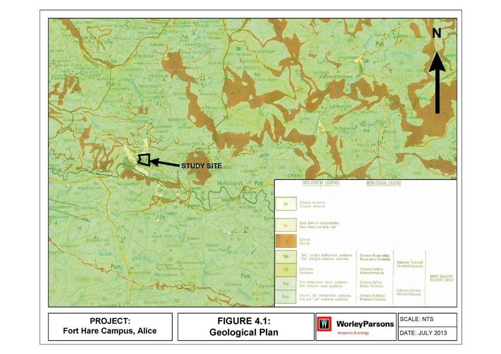
10 Page 7
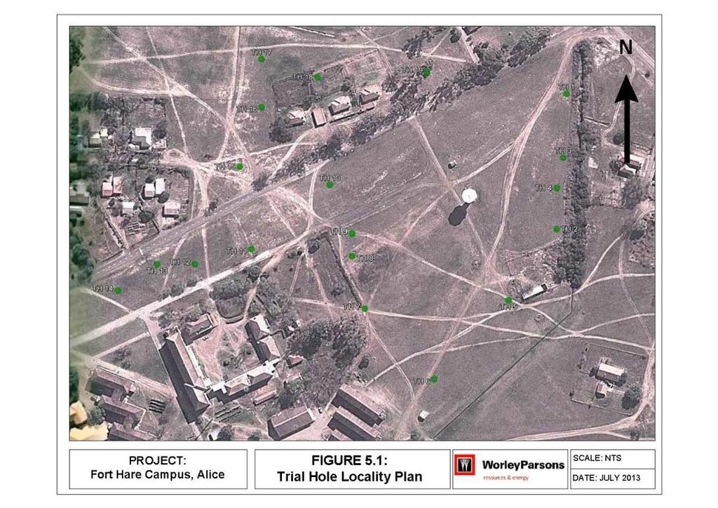
 of the new proposed residences was obtained from Mr P Ellis of MBB Consulting who indicated the")


11 5. FIELD TESTING 5.1 TRIAL HOLE INVESTIGATIONS A site plan (Figure 5.1, over page) of the new proposed residences was obtained from Mr P Ellis of MBB Consulting who indicated the proposed locations for nineteen trial holes. The trial holes were excavated by TLB on the 15/ 16 July 2013 and have been presented in DotPlot format as individual profiles as Appendix 1. Photos of each trial hole and their GPS co-ordinates are presented below, followed by a generalised profile and unconsolidated soil thickness summary of each in Table 5.1. Plate 1: Trial Hole 1 S E Plate 2: Trial Hole 2 Narrow Face S E Plate 3: Trial Hole 2 Sidewall Page 8


12 Plate 4: Trial Hole 3 Narrow Face S E Plate 5: Trial Hole 3 Sidewall Plate 6: Trial Hole 4 Narrow Face S E Plate 7: Trial Hole 4 Sidewall Page 9


13 Plate 8: Trial Hole 5 Narrow Face S E Plate 9: Trial Hole 5 Sidewall Plate 10: Trial Hole 6 Narrow Face S E Plate 11: Trial Hole 6 Sidewall Page 10


14 Plate 12: Trial Hole 7 Plate 13: Trial Hole 8 S E S E Plate 14: Trial Hole 9 Narrow Face S E Plate 15: Trial Hole 9 Sidewall Page 11


15 Plate 16: Trial Hole 10 Narrow Face S E Plate 17: Trial Hole 10 Sidewall Plate 18: Trial Hole 11 Narrow Face S E Plate 19: Trial Hole 11 Sidewall Page 12


16 Plate 20: Trial Hole 12 Narrow Face S E Plate 21: Trial Hole 12 Sidewall Plate 22: Trial Hole 13 Narrow Face S E Plate 23: Trial Hole 13 Sidewall Page 13


17 Plate 24: Trial Hole 14 Narrow Face S E Plate 25: Trial Hole 14 Sidewall Plate 26: Trial Hole 15 Narrow Face S E Page 14


18 Plate 27: Trial Hole 16 Narrow Face S E Plate 28: Trial Hole 16 Sidewall Plate 29: Trial Hole 17 Plate 30: Trial Hole 18 S E S E Page 15


19 Plate 31: Trial Hole 19 Narrow Face S E Plate 32: Trial Hole 19 Sidewall The nineteen Trial Holes on site intersected a relatively consistent profile type but with varying depth to rock/ TLB refusal as determined by individual locations. A generalised profile would be expected as follows: Slightly moist, grey/ dark brown, loose to medium dense, intact SILT: Colluvium overlying Slightly moist, dark/ olive brown, firm/ medium dense, intact/ slickensided, GRAVELLY CLAYEY SILT: Pedogenic Nodular Ferricrete overlying Slightly moist, dark/ olive brown, firm/ medium dense, intact/ slickensided, GRAVELLY CLAYEY SILT: Pedogenic Nodular Ferricrete with rounded gravel and cobbles which have calcified surfaces overlying Slightly moist olive brown, stiff, intact SILTY CLAY: Residual Olive brown, highly to moderately weathered, closely jointed, hard rock: MUDSTONE Individual Trial Hole profiles compiled in DotPlot format are presented as appended, with a Trial Hole Locality Plan shown as Figure 5.1 Depth to rock head is variable with depth to refusal also highly variable as tabulated over page. No groundwater seepage was intersected in any of the Trial Holes. Page 16
20 Table 5.1: Unconsolidated soil thickness Trial Hole Thickness of Fill (m) Thickness of Colluvium (m) Thickness of Pedogenic Nodular Ferricrete (m) Thickness of soft rock Mudstone/ Siltstone (m) Thickness of medhard rock Mudstone/ Siltstone (m) Depth of Trial Hole (m) TH TH TH TH TH TH TH TH TH TH TH TH TH TH TH TH Page 17
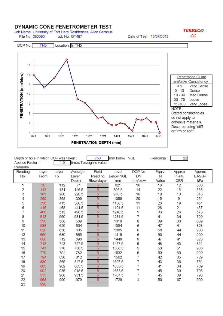
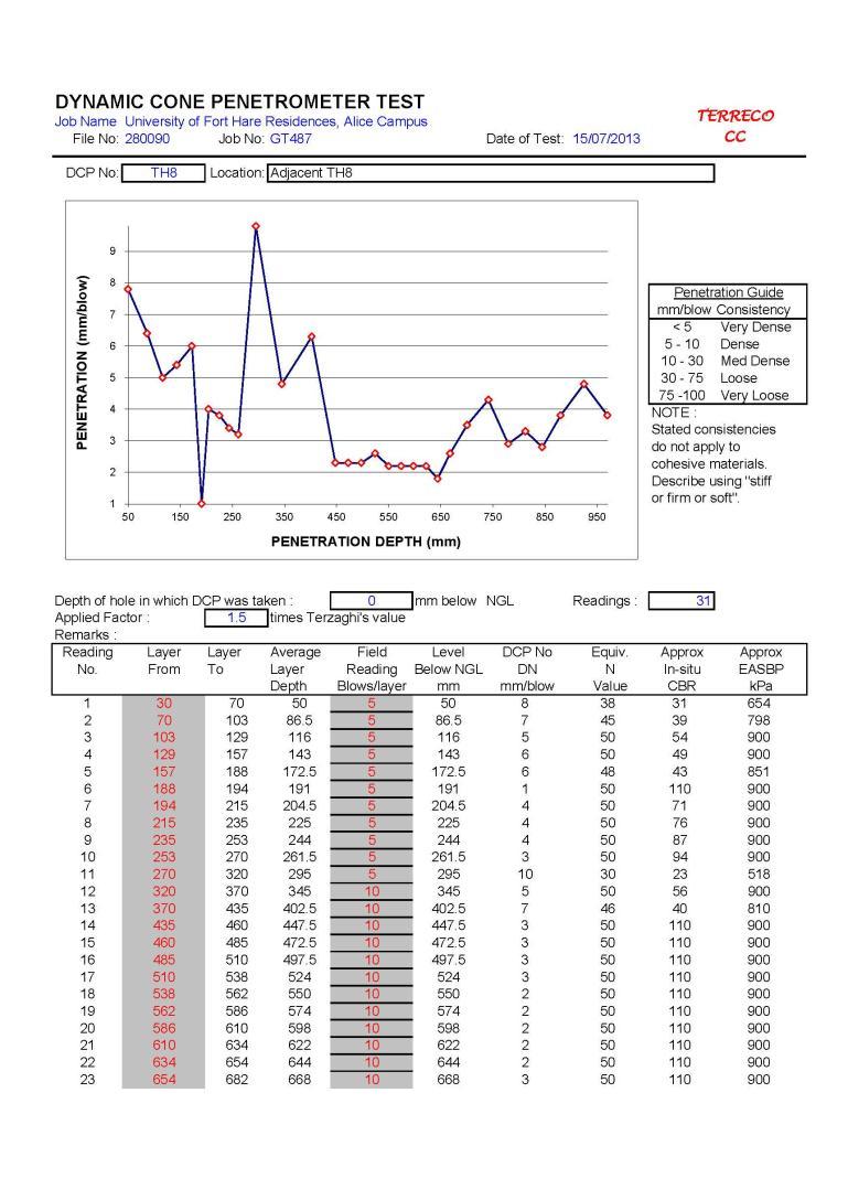
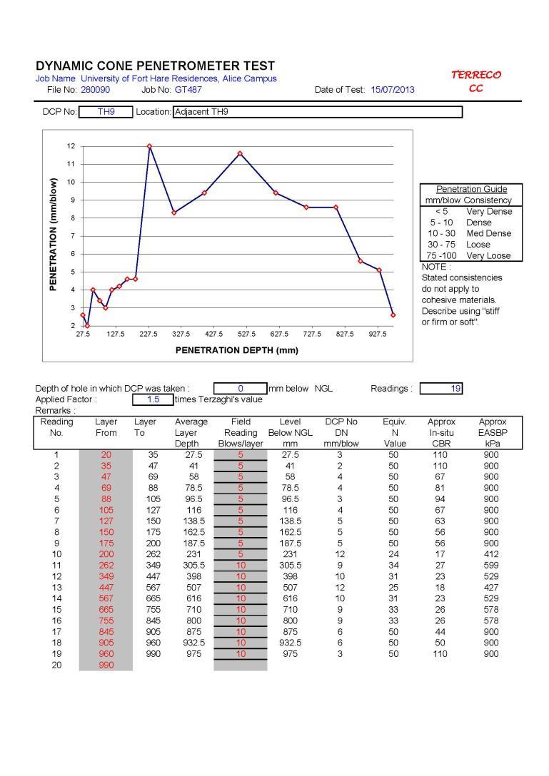
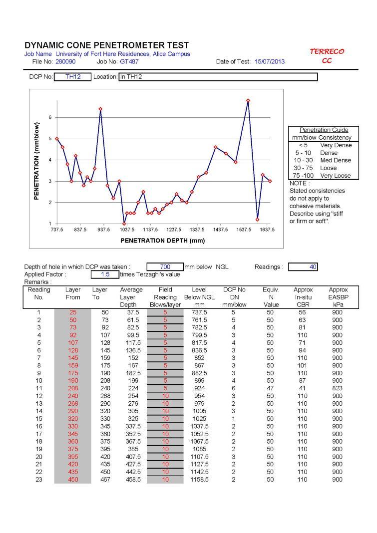
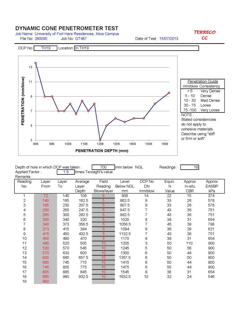
21 Trial Hole Thickness of Fill (m) Thickness of Colluvium (m) Thickness of Pedogenic Nodular Ferricrete (m) Thickness of soft rock Mudstone/ Siltstone (m) Thickness of medhard rock Mudstone/ Siltstone (m) Depth of Trial Hole (m) TH TH TH Note that Trial holes represent only point sources of information which must be kept in mind when interpreting results: depth to rockhead and TLB refusal may therefore vary, and there should be no interpolation between trial holes. 5.2 DYNAMIC CONE PENETRATION TESTING DCP tests have been undertaken adjacent to/ in most trial holes in order to estimate the bearing capacity of unconsolidated materials and underlying rock. The result of which are attached as Appendix 2. Results indicate high and consistent bearing capacities in most of the trial holes although some have very erratic and unpredictable values. Generally though the site has a good founding regime with respect to bearing capacity for the structures envisaged for the development. DCP values coinciding with the pedogenic layer yields values in excess of 300 kpa increasing with depth where harder pedogenic material is encountered and where bearing capacities can be found to be in excess of 900 kpa. The DCP test results also indicate occasional soft spots within the unconsolidated profile suggesting potential for differential settlement. It is very important to note though that DCP values should only be used for comparative purposes and not as finite standard since dynamic penetration will vary with variations in moisture content. A wet profile will therefore indicate far lower bearing capacity values. Note also that the near-surface silty and sandy materials may in the long term be compressible resulting in differential settlement under load. This too must be taken into consideration when constructing in these materials. Page 18
22 Page 19
23 6. LABORATORY TESTING 6.1 INTRODUCTION This section of the report presents the findings of laboratory testing as undertaken by Tosca Lab of Port Elizabeth on disturbed samples removed from the site. Test types and the number of tests have been undertaken according to the instructions received from the client on the day of the fieldwork conducted. Major aspects of the testing are indicated in Table 6.2, with the complete set of test results included as Appendix TEST RESULTS Laboratory foundation indicator test results are presented in Table 6.2 below. Trial Hole Number Table 6.2 Foundation indicator results Sample Depth (m) Description Equiv. PI % Clay TH2 487/2/FI/A 1.50 Clayey Silt PI LS Heave Potential Low/ Medium 487/2/FI/B 2.10 Silty Clay Low TH5 487/5/FI 1.50 Silty Clay TH7 487/7/FI/A 0.80 Silty Clay Low/ Medium Low/ Medium 487/7/FI/B 1.90 Silty Clay Low TH11 487/11/FI 1.60 Silty Clay Low TH13 487/13/FI 1.60 Silty Clay Low TH16 487/16/FI 1.50 Silty Clay Low TH18 487/18/FI 2.5 Silty Clay Low Page 20

24 Where: Equiv. PI = Equivalent Plasticity Index of whole sample % Clay = Percentage clay PI = Plasticity Index LS = Linear Shrinkage Results reveal relatively low clay percentages yet inflated Linear Shrinkage and Plasticity Indices, as high as 11.5 and 23, respectively (hence the three low/ medium heave potential as indicated in Table 6.2). Results of clay activity have been assessed and are presented in Figure 6.2. These indicate low potential for heave: mainly as a result of the low clay content. The high Linear Shrinkage and relatively high PI suggest nonetheless that the unconsolidated materials may heave and shrink on wetting and drying respectively and therefore either avoided beneath foundations or accounted for in foundation design. Figure 6.2 Clay activity chart Page 21
25 7. GEOTECHNICAL APPRAISAL 7.1 INTRODUCTION This section of the report provides geotechnical findings as based on the field tests and laboratory test results. 7.2 ENGINEERING GEOLOGY Trial holes sited and excavated at positions requested by MBB Consulting Engineers indicate a site underlain by loose to medium dense colluvial silt (or fill), overlying pedogenic gravelly clayey silt ferricrete which includes occasional rounded pebbles and cobbles in some of the deeper trail holes; in turn overlying residual clay, with refusal in some trial holes on mudstone or siltstone. The nineteen trial holes generally intersect a relatively consistent profile type but with varying depth to rock/ TLB refusal as determined by individual locations. The trial holes that intersect rock are numbered 1, 3, 4, 10 and 15. These are located on slightly higher lying areas on the eastern and central parts of the site (see Figure 5.1) and suggesting thereby, especially after consideration of the expected high clay content in the unconsolidated materials, founding on rock in these zones to nullify geotechnical problems with heave and shrinkage of clay on wetting and drying. This will though require additional detailed investigation in this area, using rather an excavator to provide greater depth of penetration, to confirm any near surface rockhead. Alternatively consideration will need to be given to founding in the deeper colluvial, pedogenic, and residual soil areas with the understanding that this will require foundation methods capable of accommodating post-construction differential movements. The magnitude of the differential movements will only become known once laboratory results have been received. 7.3 STRUCTURE FOUNDATIONS The best possible geotechnical outcome would be to construct foundations for the new buildings on rock since this will provide high bearing capacity and obviate geotechnical problems derived from active clays. Possibly too, albeit of a lesser nature, differential settlement in the near-surface loose colluvium and uncompacted fill. For foundations on rock normal strip footings would be used and if the rock does prove somewhat deep: perhaps in excess of 1,5m, then a system such as trench-fill could be considered. In trench-fill excavations are taken down to rock but then backfilled using compacted inert geotechnical materials, such as weathered dolerite sabunga, or soilcrete, or low strength mass concrete, etc., to normal strip footing invert level, and then continue using standard strip footings. Also to consider could be spot bases with ground beams and suspended floors/ strengthened floor slab if the rockhead contact is not too deep say within 5m of surface. Foundations in deeper unconsolidated materials will require more intricate structural foundation solutions to accommodate the differential foundation movements that may occur, albeit the low/ medium heave potential predicted. These could include:
26 Relatively wider and deeper footings with steel reinforcement; brickforce in the walls; and articulation of the structure by creating preformed structural cracks as per structural design requirements Alternatively stiffened raft foundations or even piling. The latter though will require additional investigation in the form of rotary cored borehole drilling. The following precautionary procedures though should, as a general rule and irrespective of the magnitude of perceived differential movements, also be considered when founding in these materials. Ensure all surface run-off is led away from structures with no ponding up against any buildings Discourage growing of plants alongside building walls and ensure no trees are planted within 10m of structures Construct a 1,5m concrete platform around each structure to move the zone of evapotranspiration away from foundation areas, and in so doing minimise moisture fluctuations. A deep subsoil drain with plastic liner on the building side of the trench can also assist in minimising moisture changes beneath foundations Provide flexible couplings for all buried services in order to minimise chances of rupture. These various options will need to be considered by the structural engineer who will ultimately decide and be responsible for the foundation designs 7.4 GEOTECHNICAL RECOMMENDATIONS It is recommended that foundations for the new structures be taken down to rock, if possible, since this is the preferred geotechnical solution. If founding on rock is not possible, then it is recommended that foundations be constructed on reinforced strip footings a minimum of 1,5m below ground (to minimise moisture fluctuations), brickforce provided in the brickwork, articulation provided in the structure to accommodates any latent differential movements and other general recommendations including a concrete paving surround, landscaping etc. as indicated in the previous section.
27 Appendix 1 - Trial Hole Logs
28
29
30
31
32
33
34
35
36
37
38
39
40
41
42
43
44
45
46
47 Appendix 2 DCP Test Results
48
49
50
51
52
53
54
55
56
57
58
59
60

61
62
63
64
65
66
67
68 Appendix 3 Laboratory Test Results
69
70
REPORT NO 12/115/D NOVEMBER 2012 GEOTECHNICAL INVESTIGATION FOR THE PROPOSED SOLAR PHOTOVOLTAIC FACILITY, GROOTVLEI POWER STATION
 Consulting Geotechnical Engineers & Engineering Geologists P.O.Box 3557 Cramerview 2060. Tel: (011) 465-1699. Fax: (011) 465-4586. Cell 082 556 7302 & 076 966 8445 REPORT NO 12/115/D NOVEMBER 2012 GEOTECHNICAL
GEOTECHNICAL INVESTIGATION FOR REDHOUSE CHELSEA ARTERIAL AND WALKER DRIVE EXTENSION, PORT ELIZABETH, EASTERN CAPE
 GEOTECHNICAL INVESTIGATION FOR REDHOUSE CHELSEA ARTERIAL AND WALKER DRIVE EXTENSION, PORT ELIZABETH, EASTERN CAPE MAY 2010 Prepared for: Prepared by: BKS (PTY) LTD TERRATEST (PTY) LTD P.O. Box 272 P.O.
UNDP HARARE HOSPITAL PROPOSED NATPHARM WAREHOUSE
 UNDP HARARE HOSPITAL PROPOSED NATPHARM WAREHOUSE January 17 2016 TO CARRY OUT IN-SITU SOIL SURVEY, LABORATORY TESTS AND GEOTECHNICAL REPORTING. GEOTECHNICAL INVESTIGATIONS REPORT 1 2 Re: GEOTECHNICAL INVESTIGATIONS
Project No.: R01
 Report to Voigts Construction on a Geotechnical Investigation carried out for the Royal Albert Lodge, Albert Falls Dam, KwaZulu-Natal Project No.: 18-156R01 Date Issued: November 2018 Report to Voigts
GEOTECHNICAL PHASE 1
 GEOTECHNICAL PHASE 1 FOR PROPOSED SKUKUZA SAFARI LODGE FOR KRUGER NATIONAL PARK MPUMALANGA PROVINCE SEPTEMBER 2014 Report No: G14-0902 Issue 2 Prepared by: Conic North Consulting Engineers PO Box 11862
DRENNAN, MAUD & PARTNERS
 DRENNAN, MAUD & PARTNERS Consulting Civil Engineers and Engineering Geologists Registered Member : S.A. Association of Consulting Engineers PARTNERS: R.D. COLLYER, Pr.Eng.,B.Sc.(Eng.),M.Sc.(Eng.),MSAICE.
 5.2 APPENDIX D2 Geotechnical Report Jeffares & Green: 03524: Ilinge and Lesseyton Cemetery Development ILINGE AND LESSEYTON CEMETERY DEVELOPMENT - GEOTECHNICAL INVESTIGATION FINAL REPORT SEPTEMBER 2014
Telephone : G. Ntaka : Fax : M. Bénet :
 Our Ref: P 24058 Your Ref: Drennan Maud cc. CK 95/54198/23 Consulting Geotechnical Engineers & Engineering Geologists VAT Reg ¹ 4770223594 P.O. Box 22997 Unit 7, Gayridge Business Park ¹ 2 MARGATE 13 Wingate
Appendix A. Producer Statement Advisory Note
 Appendix A Producer Statement Advisory Note Ref. No. 17095 26 May 2017 PRODUCER STATEMENT CONSTRUCTION REVIEW (PS4) IMPORTANT ADVISORY NOTE The Building Consent Authority (BCA) frequently requires Producer
Milford Centre Ltd. Private Plan Change GEOTECHNICAL ASSESSMENT
 Milford Centre Ltd. Private Plan Change GEOTECHNICAL ASSESSMENT Final 15 April 2008 Milford Centre Ltd. Private Plan Change GEOTECHNICAL ASSESSMENT Final 15 April 2008 Sinclair Knight Merz 25 Teed Street
ECoast Homes Pty Ltd: Proposed 76-lot subdivision, Penquite Road, Newstead GEOTECHNICAL ASSESSMENT 7 April 2009
 99 Attachment 11 (8 pages including this page) Interpretation of site geology and soils, laboratory test results, and generalised AS2870 classifications 100 Geological setting The proposed subdivision
REPORT ON THE ASSESSMENT OF TRENCHING INTHE ROAD RESERVE OF THE ROAD BETWEEN BEAUFORT WEST AND CARNAVON.
 Contract Report CSIR/BE/TIE/SKA/59E2214 August 2018 REPORT ON THE ASSESSMENT OF TRENCHING INTHE ROAD RESERVE OF THE ROAD BETWEEN BEAUFORT WEST AND CARNAVON. Authors: Dave Ventura Anele Sambo Michael Roux
 Project: ITHACA-TOMPKINS REGIONAL AIRPORT EXPANSION Project Location: ITHACA, NY Project Number: 218-34 Key to Soil Symbols and Terms TERMS DESCRIBING CONSISTENCY OR CONDITION COARSE-GRAINED SOILS (major
Report to Tyris Realty on a Geotechnical Investigation for a Proposed Warehouse Development at Sprite Place, Westmead
 Report to Tyris Realty on a Geotechnical Investigation for a Proposed Warehouse Development at Sprite Place, Westmead Reference : 11-358 Dated : February 2012 MOORE SPENCE JONES (PTY) LTD Consulting Geotechnical,
 5.2 APPENDIX D2 Geotechnical Report Jeffares & Green: 03524: Ilinge and Lesseyton Cemetery Development ILINGE AND LESSEYTON CEMETERY DEVELOPMENT - GEOTECHNICAL INVESTIGATION FINAL REPORT SEPTEMBER 2014
APPENDIX A. Borehole Logs Explanation of Terms and Symbols
 APPENDIX A Borehole Logs Explanation of Terms and Symbols Page 153 of 168 EXPLANATION OF TERMS AND SYMBOLS The terms and symbols used on the borehole logs to summarize the results of field investigation
General. DATE December 10, 2013 PROJECT No TO Mary Jarvis Urbandale/Riverside South Development Corporation
 DATE December 10, 201 PROJECT No. 10-1121-0260- TO Mary Jarvis Urbandale/Riverside South Development Corporation CC Justin Robitaille, Urbandale Jonathan Párraga, J.L. Richards & Associates Limited FROM
14 Geotechnical Hazards
 Volume 2: Assessment of Environmental Effects 296 14 Geotechnical Hazards Overview This Chapter provides an assessment of the underlying geotechnical conditions to identify: any potential liquefaction
GEOLOGICAL PROCESSES AND MATERIALS SGM210
 University of Pretoria GEOLOGICAL PROCESSES AND MATERIALS SGM210 23 April 2014 1 SOIL PROFILING According to Jennings, Brink & Williams (1973) Very important part of a geotechnical site investigation.
16 January 2018 Job Number: RICHARD NEWMAN C\- CLARK FORTUNE MCDONALD AND ASSOCIATES PO BOX 553 QUEENSTOWN
 16 January 2018 Job Number: 50595 RICHARD NEWMAN C\- CLARK FORTUNE MCDONALD AND ASSOCIATES PO BOX 553 QUEENSTOWN CHANSEN@CFMA.CO.NZ STORMWATER DISPOSAL ASSESSMENT Dear Richard, RDAgritech were requested
Safe bearing capacity evaluation of the bridge site along Syafrubesi-Rasuwagadhi road, Central Nepal
 Bulletin of the Department of Geology Bulletin of the Department of Geology, Tribhuvan University, Kathmandu, Nepal, Vol. 12, 2009, pp. 95 100 Safe bearing capacity evaluation of the bridge site along
APPENDIX 6: GEOTECHNICAL FEASIBILITY INVESTIGATION
 APPENDIX 6: GEOTECHNICAL FEASIBILITY INVESTIGATION ENVIRONMENTAL SCIENCE ASSOCIATES SAMANCOR CHROME, MIDDELBURG GEOTECHNICAL FEASIBILITY INVESTIGATION FOR NEW CHROME PLANT FACILITY J VAN TONDER (PrSciNat)
APPENDIX H SOIL SURVEY
 Environmental Impact Statement Beryl Solar Farm APPENDIX H SOIL SURVEY Beryl Solar Farm 16 347 Final V1 H i Geotechnical Engineers & Engineering Geologists NATA Accredited Laboratories for Asphalt, Aggregate,
Yumbah Nyamat Works Approval Application October Appendix J. Geotechnical Site Investigation
 Yumbah Nyamat Works Approval Application October 2018 Appendix J Geotechnical Site Investigation GEOTECHNICAL SITE INVESTIGATION PROJECT NO: 23269-1 Client: Proposed: Location: P DESIGN GROUP NEW AQUACULTURE
 Photo 1 - Southerly view across 2700 parking lot toward existing building. Multi-residential building borders western side of property in upper right of view. Photo 2 - Southerly view across 2750 parking
Appendix F Laboratory test results
 Appendix F Laboratory test results SOIL AND ROCK SAMPLE ANALYSIS LABORATORY TEST REPORT To: Bord Gais Copy: Orla Smyth (kkidd@bge.ie) From: Stephen Watson Laboratory Manager Causeway Geotech Ltd Tel: +44(0)2827666640
SOIL INVESTIGATION REPORT. PROPOSED HOUSING DEVELOPMENT PROJECT Coral Spring, Trelawny, Jamaica.
 SOIL INVESTIGATION REPORT PROPOSED HOUSING DEVELOPMENT PROJECT Coral Spring, Trelawny, Jamaica. Prepared for: FCS Consultants 7a Barbados Avenue Kingston 5, Jamaica Prepared by: NHL Engineering Limited
Geotechnical verification of impact compaction
 PII-73 Geotechnical verification of impact compaction P. J. Waddell1, R. A. Moyle2 & R. J. Whiteley1 1 2 Coffey Geotechnics, Sydney, Australia Coffey Geotechnics, Harrogate, UK Abstract Remediation of
Chapter 12 Subsurface Exploration
 Page 12 1 Chapter 12 Subsurface Exploration 1. The process of identifying the layers of deposits that underlie a proposed structure and their physical characteristics is generally referred to as (a) subsurface
DRENNAN MAUD (PTY) LTD
 LTD") DRENNAN MAUD (PTY) LTD GEOTECHNICAL ENGINEERS AND ENGINEERING GEOLOGISTS Incorporating Drennan Maud & Partners (Est.1975) and GAP Consulting Reg. No. 2014/038872/07 Durban Head Office Info@drennanmaud.com
DRENNAN MAUD (PTY) LTD GEOTECHNICAL ENGINEERS AND ENGINEERING GEOLOGISTS Incorporating Drennan Maud & Partners (Est.1975) and GAP Consulting Reg. No. 2014/038872/07 Durban Head Office Info@drennanmaud.com
REPORT TO TGC ENGINEERS CC. ON A GEOTECHNICAL INVESTIGATION FOR A PROPOSED NEW LANDFILL, CANDIDATE SITE 1 KRANTZ FONTEIN FARM KOKSTAD
 REPORT TO TGC ENGINEERS CC. ON A GEOTECHNICAL INVESTIGATION FOR A PROPOSED NEW LANDFILL, CANDIDATE SITE 1 KRANTZ FONTEIN FARM KOKSTAD 1. INTRODUCTION Drennan, Maud and Partners was requested by Mr Graham
GEOTECHNICAL INVESTIGATION OF RAILWAYS
 GEOTECHNICAL INVESTIGATION OF RAILWAYS Prof. Hannes Gräbe University of Pretoria Transnet Chair in Railway Engineering May 2011 Contents Cost considerations Objectives Phased approach to site investigation
Boreholes. Implementation. Boring. Boreholes may be excavated by one of these methods: 1. Auger Boring 2. Wash Boring 3.
 Implementation Boreholes 1. Auger Boring 2. Wash Boring 3. Rotary Drilling Boring Boreholes may be excavated by one of these methods: 4. Percussion Drilling The right choice of method depends on: Ground
Central Queensland Coal Project Appendix 4b Geotechnical Assessment. Environmental Impact Statement
 Central Queensland Coal Project Appendix 4b Geotechnical Assessment Environmental Impact Statement GEOTECHNICAL ASSESSMENT OF OPEN CUT MINING ADJACENT TO THE BRUCE HIGHWAY, CENTRAL QUEENSLAND COAL PROJECT
Report on Site Classification & Construction Testing
 Report on Site Classification & Construction Testing Northlakes Estate Stage 29, Cameron Park CGS1871 CGS1871 Prepared for Northlakes Pty Ltd C/- McCloy Group Pty Ltd December 2013 Report on Site Classification
Limited Geotechnical Engineering Evaluation Classroom Additions Albany County Campus Laramie, Wyoming
 Limited Geotechnical Engineering Evaluation Classroom Additions Albany County Campus 2300 Missile Drive, Cheyenne, Wyoming 82001 Phone 307-635-0222 www.stratageotech.com Limited Geotechnical Engineering
(C) Global Journal of Engineering Science and Research Management
 Global Journal of Engineering Science and Research Management") GEOTECHNCIAL ASSESSMENT OF PART OF PORT HARCOURT, NIGER DELTA FOR STRUCTURAL ANALYSIS Warmate Tamunonengiyeofori Geostrat International Services Limited, www.geostratinternational.com. *Correspondence
GEOTECHNCIAL ASSESSMENT OF PART OF PORT HARCOURT, NIGER DELTA FOR STRUCTURAL ANALYSIS Warmate Tamunonengiyeofori Geostrat International Services Limited, www.geostratinternational.com. *Correspondence
MERCURY - PERSEUS TRANSMISSION LINE ENGINEERING GEOLOGICAL ASSESSMENT FOR ROUTE 1
 MERURY - PERSEUS TRANSMISSION LINE ENGINEERING GEOLOGIAL ASSESSMENT FOR ROUTE 1 Prepared by: I KLEINHANS KNIGHT HALL HENDRY P.O. Box 72292 Lynnwood Ridge 0040 Prepared for: STRATEGI ENVIRONMENTAL FOUS
 R-1 Conveyor Relocation Project Legend 0 500 1000 1500 ft. This map is a user generated static output from an Internet mapping site and is for general reference only. Data layers that appear on this map
REPORT ON A GEOTECHNICAL INVESTIGATION FOR THE PROPOSED NEW ESKOM GENERAL LANDFILL AND HAZARDOUS WASTE FACILITY, LEPHALALE
 Inroads Consulting 1 REPORT ON A GEOTECHNICAL INVESTIGATION FOR THE PROPOSED NEW ESKOM GENERAL LANDFILL AND HAZARDOUS WASTE FACILITY, LEPHALALE 1. TERMS OF REFERENCE This report has been prepared at the
 TP-1 N61E 0 DARK BROWN SANDY SILT (ML) stiff, wet with roots (Disturbed Surficial Soil) DEPTH (FEET) 5 REDDISH BROWN SANDSTONE intensely fractured, weak to friable, deeply weathered, tight (Franciscan
GEOTECHNICAL ENGINEERING II. Subject Code : 06CV64 Internal Assessment Marks : 25 PART A UNIT 1
 GEOTECHNICAL ENGINEERING II Subject Code : 06CV64 Internal Assessment Marks : 25 PART A UNIT 1 1. SUBSURFACE EXPLORATION 1.1 Importance, Exploration Program 1.2 Methods of exploration, Boring, Sounding
Lake Rotoiti Wastewater Scheme - Stage 1 Investigations. Rotorua Lakes Council
 Lake Rotoiti Wastewater Scheme - Stage 1 Investigations Rotorua Lakes Council i Contents 1 Introduction...1 2 Site Description...1 3 Geological Setting...1 4 Geotechnical Investigation...1 4.1 Borehole
Geotechnical Engineering Report
 Geotechnical Engineering Report Turner Turnpike Widening Bridge B Bridge Crossing: South 257 th West Avenue Creek County, Oklahoma June 1, 2016 Terracon Project No. 04155197 Prepared for: Garver, LLC Tulsa,
DRENNAN MAUD (PTY) LTD
 LTD") DRENNAN MAUD (PTY) LTD GEOTECHNICAL ENGINEERS AND ENGINEERING GEOLOGISTS Incorporating Drennan Maud & Partners (Est.1975) and GAP Consulting Reg. No. 2014/038872/07 Durban Head Office Info@drennanmaud.com
DRENNAN MAUD (PTY) LTD GEOTECHNICAL ENGINEERS AND ENGINEERING GEOLOGISTS Incorporating Drennan Maud & Partners (Est.1975) and GAP Consulting Reg. No. 2014/038872/07 Durban Head Office Info@drennanmaud.com
SITE INVESTIGATION 1
 SITE INVESTIGATION 1 Definition The process of determining the layers of natural soil deposits that will underlie a proposed structure and their physical properties is generally referred to as site investigation.
Reference: R01. Dated: 18 July 2013 LEVEL 1 BEE SUPPLIER
 Geotechnical Engineering Services Engineering Geology Environmental and Groundwater Pile Integrity Testing Civil Engineering Laboratory Earthworks/Materials Supervision & Control Geotechnical Monitoring
REPORT OF PRELIMINARY GEOTECHNICAL EXPLORATION
 REPORT OF PRELIMINARY GEOTECHNICAL EXPLORATION ENKA INTERMEDIATE SCHOOL Sand Hill Road Candler, North Carolina Prepared For: BUNCOMBE COUNTY SCHOOLS Prepared By: AMEC ENVIRONMENT & INFRASTRUCTURE, INC.
Appendix J. Geological Investigation
 Appendix J Geological Investigation Appendix J Geological Environment Table of Contents Page 1 INTRODUCTION...J-1 1.1 Purpose of the Investigation...J-1 1.2 Scope of the Investigation...J-1 2 METHODO OF
Geotechnical Engineering Report
 Geotechnical Engineering Report Turner Turnpike Widening Polecat Creek Bridge (Bridge A) June 1, 2016 Terracon Project No. 04155197 Prepared for: Garver, LLC Prepared by: Terracon Consultants, Inc. TABLE
DATA REPORT GEOTECHNICAL INVESTIGATION GALVESTON CRUISE TERMINAL 2 GALVESTON, TEXAS
 DATA REPORT GEOTECHNICAL INVESTIGATION GALVESTON CRUISE TERMINAL 2 GALVESTON, TEXAS SUBMITTED TO PORT OF GALVESTON 123 ROSENBERG AVENUE, 8TH FLOOR GALVESTON, TEXAS 77553 BY HVJ ASSOCIATES, INC. HOUSTON,
SOIL AND AGGREGATE FUNDAMENTALS STUDENT GUIDE AMRC April, 2006 AREA MANAGER ROADS CERTIFICATION PROGRAM FOR EDUCATIONAL PURPOSES ONLY
 AREA MANAGER ROADS CERTIFICATION PROGRAM AMRC 2011 SOIL AND AGGREGATE FUNDAMENTALS STUDENT GUIDE FOR EDUCATIONAL PURPOSES ONLY April, 2006 WPC #28013 07/09 2009 by British Columbia Institute of Technology
DATE: 5/17/2012. LOGGED BY: Geoff Richards. COMPANY: Tetra Tech EM, Inc. DRILL FOREMAN: Walter
 ATTACHMENT 2 Page 1 of 1 B1 0 1 2 FILL, Dry; brownish red; clayey silt and gravel; ~30% gravel size fragments of dark grey microcrystalline (aphanetic), extrusive, igneous, rock 3 B1-4a 1100 B1-4b-duplicate
CONTENTS. 1. GeneralsG Field Investigation WorkG Laboratory Testing Work Surface Soil Description-- 7.
 CONTENTS Page 1. GeneralsG 4 2. Field Investigation WorkG 4 3. Laboratory Testing Work--- 5 4. Surface Soil Description-- 7 Appendix A Borehole Location Plan 11 Soil Profile-- 15 Bore Logs--=---- 18 Appendix
ADDENDUM 1 FISHER SLOUGH RESTORATION PROJECT SKAGIT COUNTY, WASHINGTON
 F I N A L A D D E N D U M 1 R E P O R T ADDENDUM 1 FISHER SLOUGH RESTORATION PROJECT SKAGIT COUNTY, WASHINGTON REPORT OF GEOTECHNICAL INVESTIGATION URS JOB NO. 3376186 Prepared for Tetra Tech Inc. 142
Introduction to Soil Mechanics Geotechnical Engineering-II
 Introduction to Soil Mechanics Geotechnical Engineering-II ground SIVA Dr. Attaullah Shah 1 Soil Formation Soil derives from Latin word Solum having same meanings as our modern world. From Geologist point
CENTRAL REGION GEOHAZARDS RISK ASSESSMENT SITE INSPECTION FORM
 SITE NUMBER AND NAME C55 H861:02 Slide LEGAL DESCRIPTION NW 14-40-14-W4 CENTRAL REGION GEOHAZARDS RISK ASSESSMENT SITE INSPECTION FORM HIGHWAY & KM NAD 83 COORDINATES N 5811217 E 437291 PREVIOUS INSPECTION
Field Exploration. March 31, J-U-B ENGINEERS, Inc. 115 Northstar Avenue Twin Falls, Idaho Attn: Mr. Tracy Ahrens, P. E. E:
 March 31, 201 11 Northstar Avenue 83301 Attn: Mr. Tracy Ahrens, P. E. E: taa@jub.com Re: Geotechnical Data Report Preliminary Phase 1 Field Exploration Revision No. 1 Proposed Rapid Infiltration Basin
Report of Preliminary Geotechnical Exploration. CSO-012 Sewer Separation Cincinnati, Hamilton County, Ohio. February, 2011
 11242843_GeoTech_Preliminary - Feburary 2011_1/40 Report of Preliminary Geotechnical Exploration CSO-012 Sewer Separation Cincinnati, Hamilton County, Ohio February, 2011 11242843_GeoTech_Preliminary -
Soil Mechanics. Chapter # 1. Prepared By Mr. Ashok Kumar Lecturer in Civil Engineering Gpes Meham Rohtak INTRODUCTION TO SOIL MECHANICS AND ITS TYPES
 Soil Mechanics Chapter # 1 INTRODUCTION TO SOIL MECHANICS AND ITS TYPES Prepared By Mr. Ashok Kumar Lecturer in Civil Engineering Gpes Meham Rohtak Chapter Outlines Introduction to Soil Mechanics, Soil
GEOTECHNICAL INVESTIGATION REPORT INFRASTRUCTURE PVT LTD
 GEOTECHNICAL INVESTIGATION REPORT Client : TAEIN CONSTRUCTION & INFRASTRUCTURE PVT LTD Office address : Flat No.104, A -Wing,1st floor,gloria Park, Paranjape Scheme, Bavdhan Khurd, Chandni Chowk, Pune
Depth (ft) USCS Soil Description TOPSOIL & FOREST DUFF
 USCS Soil Description TOPSOIL & FOREST DUFF") Test Pit No. TP-6 Location: Latitude 47.543003, Longitude -121.980441 Approximate Ground Surface Elevation: 1,132 feet Depth (ft) USCS Soil Description 0 1.5 1.5 5.0 SM 5.0 8.0 SM Loose to medium dense,
Test Pit No. TP-6 Location: Latitude 47.543003, Longitude -121.980441 Approximate Ground Surface Elevation: 1,132 feet Depth (ft) USCS Soil Description 0 1.5 1.5 5.0 SM 5.0 8.0 SM Loose to medium dense,
Civil Engineering, Surveying and Environmental Consulting WASP0059.ltr.JLS.Mich Ave Bridge Geotech.docx
 2365 Haggerty Road South * Canton, Michigan 48188 P: 734-397-3100 * F: 734-397-3131 * www.manniksmithgroup.com August 29, 2012 Mr. Richard Kent Washtenaw County Parks and Recreation Commission 2330 Platt
SLOPE STABILITY ASSESSMENT PROPOSED RESIDENTIAL SUBDIVISION 161 LAKESHORE ROAD EAST TOWN OF THE BLUE MOUNTAINS, ONTARIO
 SLOPE STABILITY ASSESSMENT PROPOSED RESIDENTIAL SUBDIVISION 161 LAKESHORE ROAD EAST TOWN OF THE BLUE MOUNTAINS, ONTARIO PETO MacCALLUM LTD. 19 CHURCHILL DRIVE BARRIE, ONTARIO L4N 8Z5 PHONE: (705) 734-3900
GNS Science, Lower Hutt, New Zealand NZSEE Conference
 A Ground Shaking Amplification Map for New Zealand U. Destegul, G. Dellow & D. Heron GNS Science, Lower Hutt, New Zealand. 2008 NZSEE Conference ABSTRACT: A ground shaking amplification map of New Zealand
Omaroro Lower Playing Field - Geotechnical Interpretive Report
 Report Omaroro Lower Playing Field - Geotechnical Interpretive Report Prepared for Wellington Water Limited Prepared by Beca Limited 1 December 2017 Omaroro Lower Playing Field - Geotechnical Interpretive
June 9, R. D. Cook, P.Eng. Soils Engineer Special Services Western Region PUBLIC WORKS CANADA WESTERN REGION REPORT ON
 PUBLIC WORKS CANADA WESTERN REGION REPORT ON GEOTECHNICAL INVESTIGATION PROPOSED MARTIN RIVER BRIDGE MILE 306.7 MACKENZIE HIGHWAY Submitted by : R. D. Cook, P.Eng. Soils Engineer Special Services Western
6.2 Geotechnical Investigation and Construction Material Survey
 6.2 Geotechnical Investigation and Construction Material Survey Geological surveys and investigations were conducted to obtain information on the subsurface geological condition required for the preliminary
APPENDIX A GEOTECHNICAL REPORT
 The City of Winnipeg Bid Opportunity No. 529-2017 Template Version: C420170317 - RW APPENDIX A GEOTECHNICAL REPORT Quality Engineering Valued Relationships KGS Group 2017 Industrial Street Rehabilitation
Saving on the Geotechnical Investigation A False Economy
 Saving on the Geotechnical Investigation A False Economy G. S. Young 1, BE, MEngSc, FIEAust and W. Ellis 2. 1 Douglas Partners Pty Ltd, 96 Hermitage Road, West Ryde, NSW 2114 PH (02) 9809 0666; email:
KDOT Geotechnical Manual Edition. Table of Contents
 KDOT Geotechnical Manual 2007 Edition The KDOT Geotechnical Manual is available two volumes. Both volumes are very large electronic (pdf) files which may take several minutes to download. The table of
5.2 APPENDIX D2 Geotechnical Report
 5.2 APPENDIX D2 Geotechnical Report Jeffares & Green: 03524: Ilinge and Lesseyton Cemetery Development ILINGE AND LESSEYTON CEMETERY DEVELOPMENT - GEOTECHNICAL INVESTIGATION FINAL REPORT SEPTEMBER 2014
Soils. Technical English - I 10 th week
 Technical English - I 10 th week Soils Soil Mechanics is defined as the branch of engineering science which enables an engineer to know theoretically or experimentally the behavior of soil under the action
A. V T = 1 B. Ms = 1 C. Vs = 1 D. Vv = 1
 Geology and Soil Mechanics 55401 /1A (2002-2003) Mark the best answer on the multiple choice answer sheet. 1. Soil mechanics is the application of hydraulics, geology and mechanics to problems relating
Manor Farm, Otley Road, Adel - preliminary findings
 005/87/ 6 th September 07 Mr G Titchmarsh Titchmarsh & Bagley. Prospect House Sovereign Street Leeds LS BJ Registered in England 07068066 Parkhill Wetherby West Yorkshire LS 5DZ T 097 55 0 www.lithos.co.uk
Todmorden Wind Farm Geotechnical Site Investigations, Calderdale, West Yorkshire
 Todmorden Wind Farm Geotechnical Site Investigations, Calderdale, West Yorkshire Archaeological Watching Brief Report Oxford Archaeology North March 2013 I and H Brown Issue No: 2012-13/1370 OA North Job
Preliminary Geotechnical Evaluation Gooseberry Point Pedestrian Improvements Whatcom County, Washington SITE AND PROJECT DESCRIPTION
 File No. 12-100 Geotechnical & Earthquake Engineering Consultants Mr. Kevin Brown, P.E. Gray & Osborne, Inc. 3710 168 th Street NE, Suite B210 Arlington, Washington 98223 Subject: Draft Report Preliminary
Northern Colorado Geotech
 PRELIMINARY GEOTECHNICAL ENGINEERING REPORT PROPOSED CECIL FARMS DEVELOPMENT WELD COUNTY ROAD 7, BETWEEN ROADS 7 AND 7 SEVERANCE, COLORADO NORTHERN COLORADO GEOTECH PROJECT NO. 0-6 APRIL 0, 06 Prepared
ATTACHMENT A PRELIMINARY GEOTECHNICAL SUMMARY
 ATTACHMENT A PRELIMINARY GEOTECHNICAL SUMMARY Kevin M. Martin, P.E. KMM Geotechnical Consultants, LLC 7 Marshall Road Hampstead, NH 0384 603-489-6 (p)/ 603-489-8 (f)/78-78-4084(m) kevinmartinpe@aol.com
Geotechnical Engineering Report
 Geotechnical Engineering Report Turner Turnpike Widening Bridge D Bridge Crossing: South 209 th West Avenue Creek County, Oklahoma June 1, 2016 Terracon Project No. 04155197 Prepared for: Garver, LLC Tulsa,
Appendix 6 Geotechnical report
 Page 56 Appendix 6 Geotechnical report 1. Introduction The following provides an initial and preliminary description/assessment of the overall geology, the likely ground conditions and preliminary geotechnical
REPORT. Housing Re-Zone. Middle Road and Iona Road - Geotechnical Investigation Report
 REPORT Housing Re-Zone Middle Road and Iona Road - Geotechnical Investigation Report Prepared for Hastings istrict Council Prepared by Tonkin & Taylor Ltd ate April 06 Job Number 464.000 istribution: Hastings
GEOTECHNICAL INVESTIGATION REPORT
 GEOTECHNICAL INVESTIGATION REPORT SOIL INVESTIGATION REPORT FOR STATIC TEST FACILITY FOR PROPELLANTS AT BDL, IBRAHIMPATNAM. Graphics Designers, M/s Architecture & Engineering 859, Banjara Avenue, Consultancy
Geotechnical Investigation Report
 Geotechnical Investigation Report Proposed Salt Storage Shed Majestic Hills Drive Hamilton Township, Ontario Hamilton Township 7 Pido Road Peterborough Ontario K9J 6X7 Canada 568 0 Report No June 08 Table
PRINCIPLES OF GEOTECHNICAL ENGINEERING
 PRINCIPLES OF GEOTECHNICAL ENGINEERING Fourth Edition BRAJA M. DAS California State University, Sacramento I(T)P Boston Albany Bonn Cincinnati London Madrid Melbourne Mexico City New York Paris San Francisco
Re: Steep Slope Assessment for 2465 Waverly Drive, Blind Bay, BC; Legal Address: Lot 39, Section 18, Township 22, Range 10, Plan 25579, W6M, KDYD.
 OEL File 1563-1 May 30, 2017 Doug Wall PO Box 774 Salmon Arm, BC V1E 4N7 Re: Steep Slope Assessment for 2465 Waverly Drive, Blind Bay, BC; Legal Address: Lot 39, Section 18, Township 22, Range 10, Plan
GEOTECHNICAL SITE INVESTIGATION REPORT SUBDIVISION - SELECTED LOTS AKISQNUK FIRST NATION WINDERMERE, BC
 GEOTECHNICAL SITE INVESTIGATION REPORT SUBDIVISION - SELECTED LOTS AKISQNUK FIRST NATION WINDERMERE, BC Prepared For: Akisqnuk First Nation Windermere, BC Box 688 Fernie, BC V0B 1M0 250 423 4829 August
Proposed Cemetery Thornhill Road. Tier One Hydrogeological Risk Assessment. Peter Mitchell Associates
 Proposed Cemetery Thornhill Road Tier One Hydrogeological Risk Assessment Peter Mitchell Associates January 2015 Executive Summary This report uses a desk-based risk assessment technique published by the
CONQUEST ENGINEERING LTD.
 CONQUEST ENGINEERING LTD. Geotechnical and Materials Engineers Concrete Technology, Blasting Consultants Construction Quality Assurance / Quality Control 8 Bluewater Road, Bedford, NS BB J6 Phone (9)85-7
REPORT ON SLOPE STABILITY INVESTIGATION DON MILLS ROAD AND EGLINTON AVENUE EAST TORONTO, ONTARIO. Prepared for:
 REPORT ON SLOPE STABILITY INVESTIGATION DON MILLS ROAD AND EGLINTON AVENUE EAST TORONTO, ONTARIO Prepared for: TORONTO AND REGION CONSERVATION AUTHORITY Prepared By: SIRATI & PARTNERS CONSULTANTS LIMITED
BP Connect Development Turangi Preliminary Geotechnical Assessment Report
 The Holmes Group BP Connect Development Turangi Preliminary Geotechnical Assessment Report The Holmes Group BP Connect Development Turangi Preliminary Geotechnical Assessment Report Prepared By Opus International
Converse Consultants Geotechnical Engineering, Environmental & Groundwater Science, Inspection & Testing Services
 Converse Consultants Geotechnical Engineering, Environmental & Groundwater Science, Inspection & Testing Services July 27, 2017 Ms. Rebecca Mitchell Mt. San Antonio College Facilities Planning & Management
Geology and Soil Mechanics /1A ( ) Mark the best answer on the multiple choice answer sheet.
 Mark the best answer on the multiple choice answer sheet.") Geology and Soil Mechanics 55401 /1A (2003-2004) Mark the best answer on the multiple choice answer sheet. 1. Soil mechanics is the application of hydraulics, geology and mechanics to problems relating
Geology and Soil Mechanics 55401 /1A (2003-2004) Mark the best answer on the multiple choice answer sheet. 1. Soil mechanics is the application of hydraulics, geology and mechanics to problems relating
Reference No S072 APRIL 2012
 A REPORT TO SOLMAR DEVELOPMENT CORP. A PRELIMINARY SOIL INVESTIGATION FOR PROPOSED SUBDIVISION DEVELOPMENT NORTHEAST OF SIDEROAD 5 AND 0 LINE TOWN OF ERIN Reference No. 202-S072 APRIL 202 DISTRIBUTION
Geotechnical Engineering Study, Conifer Senior High School Football Field Improvements, Conifer, Colorado
 2390 South Lipan Street Denver, CO 80223 phone: (303) 742-9700 fax: (303) 742-9666 email: kadenver@kumarusa.com www.kumarusa.com Office Locations: Denver (HQ), Colorado Springs, Fort Collins, and Frisco,
Geotechnical Indications Of Eastern Bypass Area In Port Harcourt, Niger Delta
 Geotechnical Indications Of Eastern Bypass Area In Port Harcourt, Niger Delta Warmate Tamunonengiyeofori Geostrat International Services Limited, Rivers State, Nigeria www.geostratinternational.com info@geostratinternational.com,
DEFINITION OF EXPANSION POTENTIAL FOR EXPANSIVE SOIL John D. Nelson 1,2, Kuo-Chieh Chao 2 & Daniel D. Overton 2
 DEFINITION OF EXPANSION POTENTIAL FOR EXPANSIVE SOIL John D. Nelson 1,2, Kuo-Chieh Chao 2 & Daniel D. Overton 2 1 ) Colorado State University, USA 2 ) Tetra Tech, Inc., USA Abstract: Expansion potential
GEOTECHNICAL REPORT CBSA Facility Redevelopment Thousand Islands International Crossing Lansdowne, Ontario
 GEOTECHNICAL REPORT CBSA Facility Redevelopment Thousand Islands International Crossing Lansdowne, Ontario Prepared For: The Federal Bridge Corporation Limited SPL Project No.: 10001084 Report Date: January
February 22, 2016 AG File No
 Ainley Graham & Associates Limited 1-50 Grant Timmins Drive, Kingston, Ontario, K7M 8N2 Tel: (343) 266-0002 Fax: (343) 266-0028 E-mail Kingston@ainleygroup.com February 22, 2016 AG File No. 15062-1 Ministry
THE INSTITUTE OF COST ACCOUNTANTS OF INDIA (ICAI)
") THE INSTITUTE OF COST ACCOUNTANTS OF INDIA (ICAI) GEOTECHNICAL INVESTIGATION REPORT FOR PROPOSED PROJECT INSTITUTIONAL BUILDING FOR ICAI AT CBD BELAPUR, NAVI MUMBAI OCTOBER 2012 1281-2012-073 BY THANE
THE INSTITUTE OF COST ACCOUNTANTS OF INDIA (ICAI) GEOTECHNICAL INVESTIGATION REPORT FOR PROPOSED PROJECT INSTITUTIONAL BUILDING FOR ICAI AT CBD BELAPUR, NAVI MUMBAI OCTOBER 2012 1281-2012-073 BY THANE