DRENNAN, MAUD & PARTNERS
|
|
|
- Amberly Kennedy
- 5 years ago
- Views:
Transcription
,M.Sc.,FSAIEG. M.J. HADLOW, Pr.Sci.Nat.,B.Sc.(Hons.),MSAIEG. CONSULTANT: R.R. MAUD, Pr.Sci.Nat.,B.Sc.,Ph.D.,FGS.,FGSSA., FSAIEG.")


1 DRENNAN, MAUD & PARTNERS Consulting Civil Engineers and Engineering Geologists Registered Member : S.A. Association of Consulting Engineers PARTNERS: R.D. COLLYER, Pr.Eng.,B.Sc.(Eng.),M.Sc.(Eng.),MSAICE. M.J.F. BÉNET, Pr.Sci.Nat.,B.Sc.(Hons.),M.Sc.,FSAIEG. M.J. HADLOW, Pr.Sci.Nat.,B.Sc.(Hons.),MSAIEG. CONSULTANT: R.R. MAUD, Pr.Sci.Nat.,B.Sc.,Ph.D.,FGS.,FGSSA., FSAIEG.,FSAII 68 RIDGE ROAD TOLLGATE DURBAN 4001 P.O. BOX MAYVILLE 4058 OUR REF.: YOUR REF.: 23311REV1 TELEPHONE (031) TELEFAX (031) dmp@iafrica.com th 30 November 2012 Tongaat Hulett Developments P.O. Box GLENASHLEY Greg.Veerasamy@tongaat.com Attention : Mr Greg Veerasamy Dear Sirs, REPORT ON THE GEOTECHNICAL INVESTIGATION FOR THE SUITABILITY FOR DEVELOPMENT OF AN AREA DESIGNATED AS CANELANDS EAST, VERULAM Further to our discussions and appointment to undertake the above-mentioned th investigation, we confirm that the field work has now been completed on the 18 August SITE DESCRIPTION The site comprises a total area of 7.22 ha and is situated in the outer north eastern part of Canelands, Verulam. The site is located directly south of the meandering Umdloti River and is bordered by Dow AgroSciences and the Verulam-tongaat Railway line to the east and south respectively. The majority of the site is presently under cane cultivation by a farmer lessee to the Client.
2 Ref Rev1 Tongaat Hulett Developments Canelands East, Verulam Page ¹ 2 A triangular shape portion of the total area has mistakenly been included into the fenced off area of Dow AgroSciences SA (Pty) Ltd. The gravel access road leading to Dow AgroSciences SA (Pty) Ltd along which servitudes and a substation are present crosses through the centre of the site. The southern boundary of the site is marked by the property of the railways accommodating the main railway line connecting Tongaat with Verulam. The southern part of the project area south of the road crossing through the project area is sloping gently with a concave slope conformation in a north to north-westerly direction. The northern part comprises a fairly level north-western portion with a wider north westerly trending valley line located to the north east. The entire valley line has been marked as wetland by the Client as has the outermost south eastern part. 2. FIELD INVESTIGATION The field work comprised the mechanical excavation of inspection pits using a 4x4 TLB provided, supplemented with dynamic cone penetrometer tests and hand auger excavations as well as material sampling. Three representative samples were collected and taken to Thekwini Soils Laboratory in order to determine materials suitability for further use in construction. The field investigation was partly restricted by the presence of infrastructures such as servitudes, roads, fences and a substation. Further agreement was reached with the farming lessee to minimize crop damage. In total an area of 4.65 ha was classified on the plan provided either as wetland areas, lying below the theoretical 100-year-flood-line or as existing services was excluded. Separate access had to be arranged for the triangular area fenced off by Dow AgroSciences SA (Pty) Ltd. Due to TLB accessibility restrictions, only auger excavations and dynamic cone penetrometer tests were proposed for this portion. However, on the day of testing, the entire area was flooded, which is a common occurance according to the representatives of Dow AgroSciences SA (Pty) Ltd). As such field work was restricted to a single auger excavation and a single dynamic cone penetrometer test. 2.1 Inspection Pits (IP 1 - IP 9) A total of nine inspection pits were excavated across the project area. The subsoil profiles exposed were examined and logged. The pits were numbered IP 1 to IP 9 and the approximate positions are marked on the site plan (Figure 1). The logs are presented in Appendix 1 included at the rear of this report.
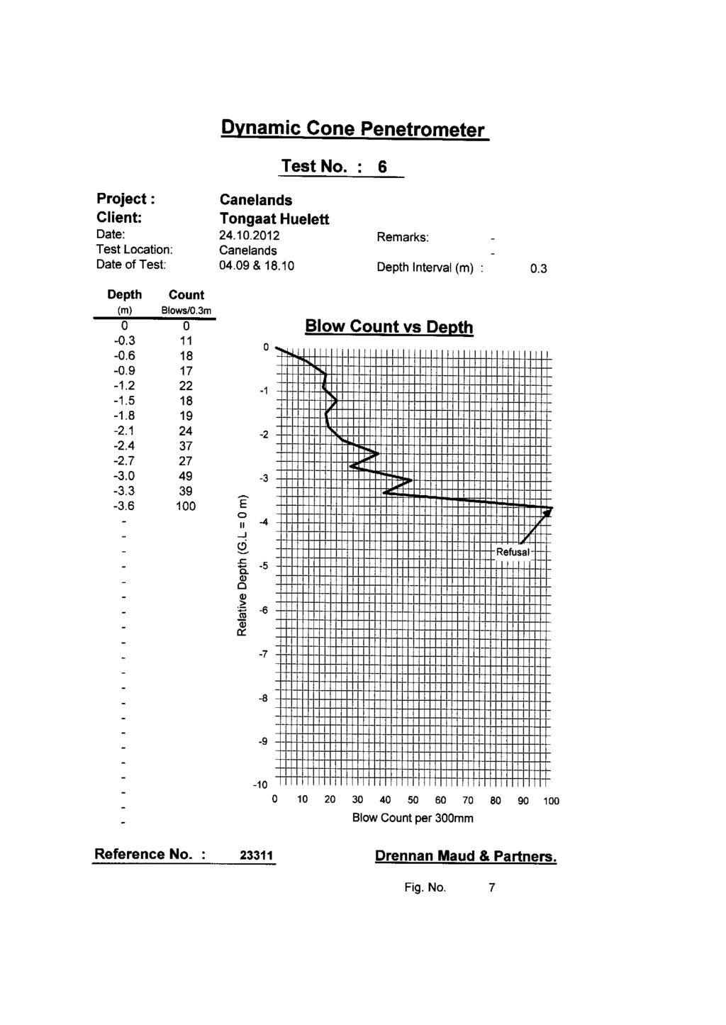
3 Ref Rev1 Tongaat Hulett Developments Canelands East, Verulam Page ¹ Auger Excavations (AH 1 - AH 3) A total of three hand augers were excavated, two along slopes of the main valley line and a third within the previously mentioned fenced off area. Both excavations along the embankment met with refusal at shallow depths less than 500mm on what is believed to be boulders. Due to flooding within the fenced area only one auger hole (AH3) was excavated. All the auger hole profiles are included in Appendix 1 of this report. 2.3 Dynamic Cone Penetration Testing A total of 13 Dynamic Cone Penetrometer probes (DCP s) were carried out. The aim of DCP testing was to establish the consistency of the subsoil underlying the site at shallow to moderate depths as well as to establish the depth to weathered bedrock. The DCP results are recorded graphically in Figures 2 to 14 and represented as Appendix 2. In order to facilitate the interpretation of the DCP test results with respect to the subsoil consistency in the non-cohesive and cohesive materials underlying the site, the following Table is provided as a guide only. Table 1 : Subsoil Consistency Inferred from the DCP Test Results Cohesive Soils Non-Cohesive Soils DCP Blow Count Blow /300mm Subsoil Consistency DCP Blow Count Blows /300mm Subsoil Consistency 0-4 Very Soft 0-8 Very Loose 4-8 Soft 8-18 Loose 8-15 Firm Medium Dense Stiff Dense Very Stiff >90 Very Dense > 54 Hard Specific to DMP equipment 3. GEOLOGY AND SOILS The majority of the project area is underlain by the diamictic bedrock of the Ordovician Dwyka Formation and the soils derived therefrom. Along the upper slope of the valley as well as at the northern end of the project area. Quaternary alluvial terrace sediments comprising loose sands, gravel and boulder capping the Dwyka Formation at depth. Pits could not be established along the valleys embankment due to the limited accessibility for the TLB, furthermore hand auger excavations refused at shallow depths on likely boulders contained within the alluvial terrace sediments.
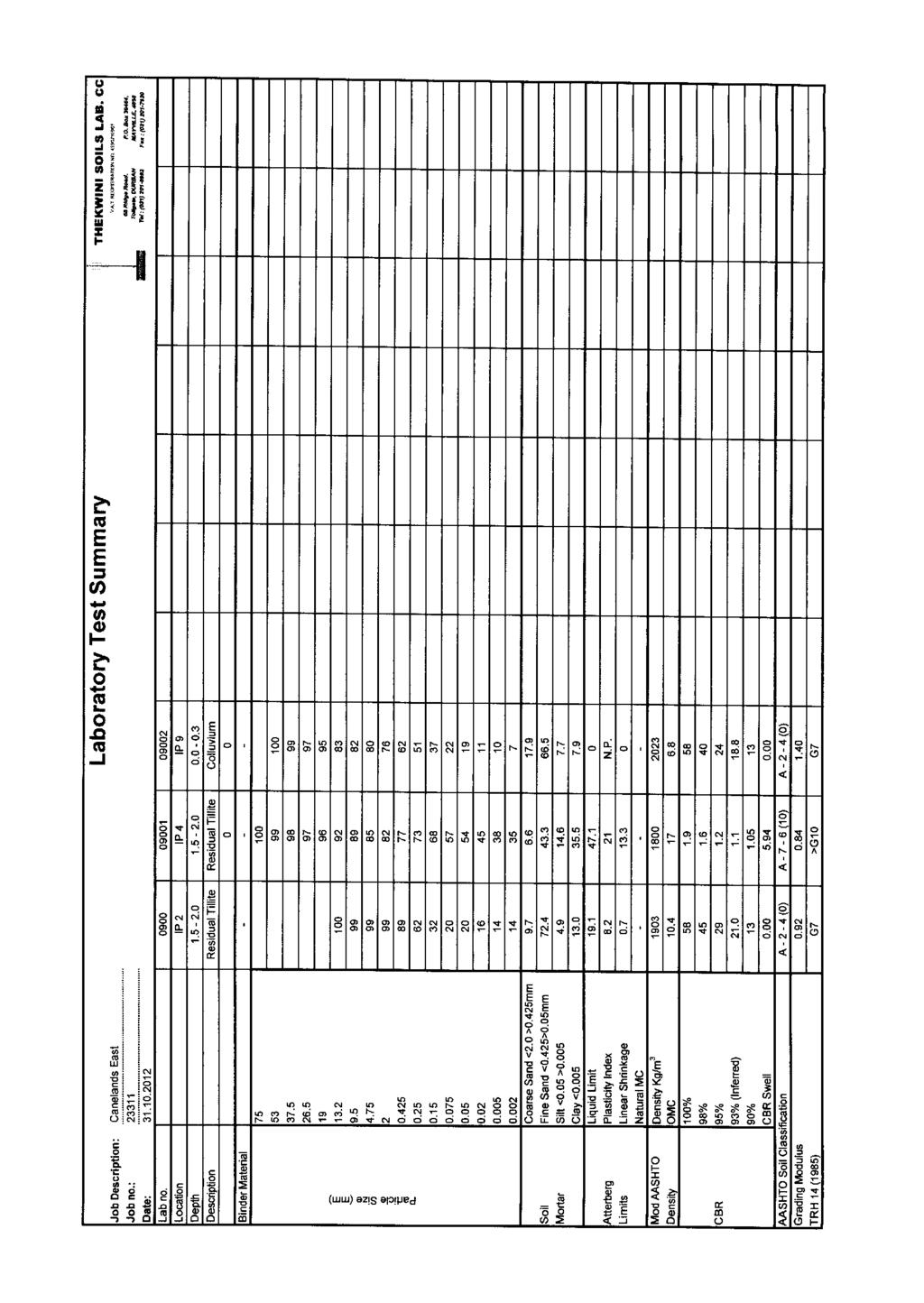
4 Ref Rev1 Tongaat Hulett Developments Canelands East, Verulam Page ¹ 4 Fill materials were encountered along the western portion of the site. We assume, a north west - south east trending depression or shallow drainage line leading towards the Dow AgroSciences SA (Pty) Ltd pond has been filled in order to level the area. In general the depth to completely to highly weathered, very soft rock, sedimentary bedrock exceeds 3.00m depth with the exception of the south western most area where weathered bedrock was exposed at a depth of 2.40m below existing ground level in IP5. Loose alluvial terrace sediments associated with the nearby meandering umdloti River cap the underlying Dwyka Formation both along the embankment of the valley line as well as at the north western boundary around IP LABORATORY RESULTS A total of three representative bulk samples recovered were taken to Thekwini Soils Laboratory for testing which included full grading analyses, Mod AASHTO and CBR tests to determine the suitability of the materials for possible use as construction material. The results are summarised in Table 2 below and listed as Figures 15, 16 and 17 in Appendix 3 included at the end of this report 4.1 Results Table 2 : Laboratory tests and Result summary IP ¹ Depth (m) Description Tests Results Full Ind Mod AASHTO CBR AASHTO Class THR Residual Tillite Residual Tillite A-2-4(0) G7 A-7-6(10) >G Colluvium A-2-4(0) G Colluvium The material encountered in IP 9 classifies as a gravelly sand with a clay content of 7.4% and a grading modulus of The material is non-plastic and has no linear shrinkage. In terms of the Revised U.S. Classification this material classifies as an A (0) which is considered an excellent to good subgrade material.
5 Ref Rev1 Tongaat Hulett Developments Canelands East, Verulam Page ¹ 5 The maximum Mod AASHTO density of the material is 2023 kg/m³ at an optimum moisture content of 6.8 %. The material has a CBR of 19 at a compaction of 93% increasing to 40 at a compaction of 98% of the materials maximum Mod AASHTO density. The material has no CBR swell. In terms of TRH 14 (1985) the material classifies as a G7 material and is considered suitable for re-use as subgrade and in selected layer works for road and pavement works Residual Tillite The residual material encountered in IP 2 classifies as a clayey sand with a clay content of 14.2% and a grading modulus of The plasticity index of the materials fines is 8.2 with a linear shrinkage of 0.7%. In terms of the Revised U.S. Classification these materials are A (0) which is considered an excellent to good subgrade material. The maximum Mod AASHTO density of the material is 1903 kg/m³ at an optimum moisture content of 10.4 %. The material has a CBR of 21 at a compaction of 93% increasing to 45 at a compaction of 98% of the materials maximum Mod AASHTO density. The material has no CBR swell. In terms of TRH 14 (1985) the material classifies as a G7 material and is considered suitable for re-use as subgrade and in selected layer works for road and pavement works. The residual material encountered in IP 4 classifies as a gravelly, sandy, silty clay with a clay content of 34.6% and a grading modulus of The plasticity index of the materials fines is 21 with a linear shrinkage of 13.3%. In terms of the Revised U.S. Classification these materials are A (10) which is considered a fair to poor subgrade material. The maximum Mod AASHTO density of the material is 1800 kg/m³ at an optimum moisture content of 17 %. The material has a CBR of 1.1 at a compaction of 93% increasing to 1.6 at a compaction of 98% of the materials maximum Mod AASHTO density. The material has a maximum CBR swell of 3.69%. Due to the low CBR results, in terms of TRH 14 (1985) the material does not classify as a G10 material and is not considered suitable in road and pavement layer works.
6 Ref Rev1 Tongaat Hulett Developments Canelands East, Verulam Page ¹ 6 5. GEOTECHNICAL ASSESSMENT 5.1 Excavatabliity Excavatability in general is expected to be soft according to SABS 1200D through the fill body, colluvial, alluvial as well as completely weathered bedrock. Abnormal fill material, boulders or less weathered dropstones as are common within the Dwyka tillite and the soils deriving therefrom might reduce the trenchability locally. Blasting of sizable relic dropstones / corestones might be required locally. 5.2 Subsoil Seepage Subsoil seepage was identified during the investigation predominantly within the residual and completely to highly weathered Dwyka Formation. Additionally perched water tables may build up during periods of high rain fall, at the base of the loose alluvial terraces where underlain by less permeable in-situ materials. 5.3 Founding Conditions Throughout the site founding conditions within competent residual and the upper competent weathered sedimentary bedrock of the Dwyka Formation are considered good. The bearing capacity of the in-situ sandy clays and clayey sand may locally allow up to a maximum of 150kPa, whereas competent weathered Dwyka bedrock is likely to exceed 200 kpa depending on the composition and degree of weathered bedrock. In general neither fill materials, nor colluvial or alluvial materials are considered suitable for founding and all founding should ideally be taken through these materials into competent materials of the Dwyka Formation. 6. CONCLUSION 6.1 In terms of the results of this assessment, we consider the investigated 2.54ha portion of the 7.22ha site as stable in its existing condition, and capable of development as such. The development of the site should, however, be carried out in terms of the recommendations given below. These recommendations amount to no more than sound building practices, appropriate for the geotechnical conditions existing on the site. Areal restrictions are given by the legislation regarding buffer zones for any proposed development within a certain proximity of wetlands, 100-year-flood lines, servitudes and substations as present in the area.
7 Ref Rev1 Tongaat Hulett Developments Canelands East, Verulam Page ¹ 7 7. GENERAL DEVELOPMENT RECOMMENDATIONS 7.1 General Development It must be understood, all development will be restricted by the existing servitudes and the areas designated as wetland and within the 100-year-flood line with the buffer zones applying. However, the remaining areas are considered suitable for general development. We assume, it is most likely to create individual platforms suitable for proposed development. Within the southern portion of the area, given the generally gently sloping concave topography, some earthworks will be required, consisting of cutting and / or filling for the creation of engineered platforms. 7.2 Earthworks Excavation is considered soft according SABS 1200D through all fill material and residual clays into the upper weathered diamictic bedrock of the Ordovizian Dwyka Formation. Shoring of any excavation deeper than 1.20m is advised and must be implemented at the discretion of the Engineer. Where the alluvial terraces are present along the southern embankment of the north easterly valley sidewalls are likely to be unstable and might have to be shored at depth less than 1.20m. Aggressive earthworks along the southern boundary may endanger the stability of the adjacent railway line. Any earthworks in the vicinity of the railway line may require detailed geotechnical studies. Although no further details on any proposed development have been made available at this stage, general recommendations regarding cut and fill embankments are given below Cut Embankments We assume building platforms are likely to be created for potential development. Since no details have been forwarded, the following will be of a general nature. As soon as the individual sites have been identified more specific recommendations can be made: Building platforms should ideally be created entirely in cut. All permanent cut slopes into sandy materials should be restricted to a maximum of 1:2 (26 ). The maximum height of any cut slope should not exceed 3.00m without being assessed by an Engineering Geologist.
8 Ref Rev1 Tongaat Hulett Developments Canelands East, Verulam Page ¹ 8 All permanent cut slope batters into clayey materials should be trimmed back to a maximum batter of 1:1.75 (30 ). Temporary cut banks during construction may be laid back to a slope batter of 1:1.5 (33 ). All cut embankments must be protected against surface erosion by the planting of vegetation immediately after construction. In the hard to medium weathered bedrock, cut slopes may be steepened to 1:1 (45 ) or steeper at the discretion of the Engineer. Should it not be possible to accommodate the above slope angles, the slopes will need to be supported by retaining structures. In addition, it may be necessary to shore excavations or cut faces during construction Fill Embankments Where fill platforms have to be created the following generalized recommendations apply: Fill platforms should not be placed onto any unstable materials such as colluvium materials or alluvial terraces. Prior to the placement of any fill the in-situ subsoil materials containing vegetation should be removed. The fills should be constructed in layers not exceeding a maximum of 300mm loose thickness and be compacted to 93% of the materials maximum Mod AASHTO Density for clayey materials and 95% of the materials maximum Mod AASHTO Density for sandy materials prior to the placement of the next layer. The maximum particle size within the fill should be restricted to two thirds of the layers loose thickness. Permanent fill batters should be no steeper than 1:1,75(30 ) and should not exceed a maximum vertical height of about 3m. For generally well constructed engineered fills, internal settlements within the fill of up to 1% of the fill thickness should be anticipated. As such, settlements across the cut/fill line or from natural ground to maximum fill, depending on the thickness of fill, may vary across the platform.
9 Ref Rev1 Tongaat Hulett Developments Canelands East, Verulam Page ¹ Subsoil Drainage Seepage may occur along the contact between the capping colluvial sandy materials and the in-situ residual clays or weathered bedrock formations during periods of high rainfall. Control of seepage by the installation of subsoil drains may be necessary locally depending on the nature of the development. 7.4 Sanitation Due to the site being situated inbetween two areas apparently classified as wetland, all effluent waters should ideally be collected and piped towards the nearest treatment system. Alternatively, systems such as conservancy tanks or package plant may be considered. Systems such as french drain systems are not considered ideal due to the amount of unsealed area required for evapotranspiration and environmental restrictions implemented by the nearby eco-sensitive wetlands. 7.5 Materials The colluvium material encountered classified as a G7 material, whereas the residual in-situ soils varied from a G7 sandy material to a clay material not classifying as a G10 material. We expect the in-situ residual soils and upper completely to highly weathered bedrock materials of the Ordovizian Dwyka Formation to provide materials within this range, depending on the composition as well as the degree of weathering. We trust that this report meets your immediate requirements. Yours faithfully DRENNAN, MAUD & PARTNERS M.J. HADLOW Pr.Sci.Nat. Encls. Appendix 1 - Soil Profiles Appendix 2 - DCP s 1-13 Appendix 3 - Lab Test Results Figure 1 - Site Plan /kmc/aj/kc
10 APPENDIX 1 SOIL PROFILES (IP 1 - IP 9 & AH 1 - AH 3)
11 APPENDIX 2 DYNAMIC CONE PENETROMETER TEST RESULTS (DCP 1 - DCP 13)
12 APPENDIX 3 LABORATORY TEST RESULTS
13 FIGURE 1 SITE PLAN
14
15
16
17
18
19
20
21
22
23
24
25
26
27
28
29
30
31
32
33
34
35
36
37
38
39
40
41
42


43 CANELANDS EAST AH1 DCP11 X X DCP12 IP9 AH2 X DCP10 IP8 IP1 X X X DCP1 DCP9 DCP13/AH3 IP2 X DCP2 IP3 DCP7 X X DCP8 X DCP3 IP6 IP4 DCP6 IP7 X DCP5 DCP4 X X IP5 KEY DCP1 X APPROX. POSITION OF DYNAMIC CONE PENETROMETER TESTS REF. NO FIG. NO. 1 DRENNAN, MAUD & PARTNERS Consulting Civil Engineers & Engineering Geologists IP1 AH1 APPROX. POSITION OF INSPECTION PITS APPROX. POSITION OF AUGER HOLE 68 Ridge Road Tollgate DURBAN 4001 Telephone P.O. Box MAYVILLE 4058 Telefax dmp@iafrica.com
Telephone : G. Ntaka : Fax : M. Bénet :
 Our Ref: P 24058 Your Ref: Drennan Maud cc. CK 95/54198/23 Consulting Geotechnical Engineers & Engineering Geologists VAT Reg ¹ 4770223594 P.O. Box 22997 Unit 7, Gayridge Business Park ¹ 2 MARGATE 13 Wingate
DRENNAN MAUD (PTY) LTD
 LTD") DRENNAN MAUD (PTY) LTD GEOTECHNICAL ENGINEERS AND ENGINEERING GEOLOGISTS Incorporating Drennan Maud & Partners (Est.1975) and GAP Consulting Reg. No. 2014/038872/07 Durban Head Office Info@drennanmaud.com
DRENNAN MAUD (PTY) LTD GEOTECHNICAL ENGINEERS AND ENGINEERING GEOLOGISTS Incorporating Drennan Maud & Partners (Est.1975) and GAP Consulting Reg. No. 2014/038872/07 Durban Head Office Info@drennanmaud.com
REPORT NO 12/115/D NOVEMBER 2012 GEOTECHNICAL INVESTIGATION FOR THE PROPOSED SOLAR PHOTOVOLTAIC FACILITY, GROOTVLEI POWER STATION
 Consulting Geotechnical Engineers & Engineering Geologists P.O.Box 3557 Cramerview 2060. Tel: (011) 465-1699. Fax: (011) 465-4586. Cell 082 556 7302 & 076 966 8445 REPORT NO 12/115/D NOVEMBER 2012 GEOTECHNICAL
Report to Tyris Realty on a Geotechnical Investigation for a Proposed Warehouse Development at Sprite Place, Westmead
 Report to Tyris Realty on a Geotechnical Investigation for a Proposed Warehouse Development at Sprite Place, Westmead Reference : 11-358 Dated : February 2012 MOORE SPENCE JONES (PTY) LTD Consulting Geotechnical,
GEOTECHNICAL INVESTIGATION FOR REDHOUSE CHELSEA ARTERIAL AND WALKER DRIVE EXTENSION, PORT ELIZABETH, EASTERN CAPE
 GEOTECHNICAL INVESTIGATION FOR REDHOUSE CHELSEA ARTERIAL AND WALKER DRIVE EXTENSION, PORT ELIZABETH, EASTERN CAPE MAY 2010 Prepared for: Prepared by: BKS (PTY) LTD TERRATEST (PTY) LTD P.O. Box 272 P.O.
REPORT TO TGC ENGINEERS CC. ON A GEOTECHNICAL INVESTIGATION FOR A PROPOSED NEW LANDFILL, CANDIDATE SITE 1 KRANTZ FONTEIN FARM KOKSTAD
 REPORT TO TGC ENGINEERS CC. ON A GEOTECHNICAL INVESTIGATION FOR A PROPOSED NEW LANDFILL, CANDIDATE SITE 1 KRANTZ FONTEIN FARM KOKSTAD 1. INTRODUCTION Drennan, Maud and Partners was requested by Mr Graham
UNDP HARARE HOSPITAL PROPOSED NATPHARM WAREHOUSE
 UNDP HARARE HOSPITAL PROPOSED NATPHARM WAREHOUSE January 17 2016 TO CARRY OUT IN-SITU SOIL SURVEY, LABORATORY TESTS AND GEOTECHNICAL REPORTING. GEOTECHNICAL INVESTIGATIONS REPORT 1 2 Re: GEOTECHNICAL INVESTIGATIONS
SOIL INVESTIGATION REPORT. PROPOSED HOUSING DEVELOPMENT PROJECT Coral Spring, Trelawny, Jamaica.
 SOIL INVESTIGATION REPORT PROPOSED HOUSING DEVELOPMENT PROJECT Coral Spring, Trelawny, Jamaica. Prepared for: FCS Consultants 7a Barbados Avenue Kingston 5, Jamaica Prepared by: NHL Engineering Limited
Central Queensland Coal Project Appendix 4b Geotechnical Assessment. Environmental Impact Statement
 Central Queensland Coal Project Appendix 4b Geotechnical Assessment Environmental Impact Statement GEOTECHNICAL ASSESSMENT OF OPEN CUT MINING ADJACENT TO THE BRUCE HIGHWAY, CENTRAL QUEENSLAND COAL PROJECT
16 January 2018 Job Number: RICHARD NEWMAN C\- CLARK FORTUNE MCDONALD AND ASSOCIATES PO BOX 553 QUEENSTOWN
 16 January 2018 Job Number: 50595 RICHARD NEWMAN C\- CLARK FORTUNE MCDONALD AND ASSOCIATES PO BOX 553 QUEENSTOWN CHANSEN@CFMA.CO.NZ STORMWATER DISPOSAL ASSESSMENT Dear Richard, RDAgritech were requested
GEOTECHNICAL PHASE 1
 GEOTECHNICAL PHASE 1 FOR PROPOSED SKUKUZA SAFARI LODGE FOR KRUGER NATIONAL PARK MPUMALANGA PROVINCE SEPTEMBER 2014 Report No: G14-0902 Issue 2 Prepared by: Conic North Consulting Engineers PO Box 11862
 5.2 APPENDIX D2 Geotechnical Report Jeffares & Green: 03524: Ilinge and Lesseyton Cemetery Development ILINGE AND LESSEYTON CEMETERY DEVELOPMENT - GEOTECHNICAL INVESTIGATION FINAL REPORT SEPTEMBER 2014
 5.2 APPENDIX D2 Geotechnical Report Jeffares & Green: 03524: Ilinge and Lesseyton Cemetery Development ILINGE AND LESSEYTON CEMETERY DEVELOPMENT - GEOTECHNICAL INVESTIGATION FINAL REPORT SEPTEMBER 2014
June 9, R. D. Cook, P.Eng. Soils Engineer Special Services Western Region PUBLIC WORKS CANADA WESTERN REGION REPORT ON
 PUBLIC WORKS CANADA WESTERN REGION REPORT ON GEOTECHNICAL INVESTIGATION PROPOSED MARTIN RIVER BRIDGE MILE 306.7 MACKENZIE HIGHWAY Submitted by : R. D. Cook, P.Eng. Soils Engineer Special Services Western
Appendix A. Producer Statement Advisory Note
 Appendix A Producer Statement Advisory Note Ref. No. 17095 26 May 2017 PRODUCER STATEMENT CONSTRUCTION REVIEW (PS4) IMPORTANT ADVISORY NOTE The Building Consent Authority (BCA) frequently requires Producer
 R-1 Conveyor Relocation Project Legend 0 500 1000 1500 ft. This map is a user generated static output from an Internet mapping site and is for general reference only. Data layers that appear on this map
A. V T = 1 B. Ms = 1 C. Vs = 1 D. Vv = 1
 Geology and Soil Mechanics 55401 /1A (2002-2003) Mark the best answer on the multiple choice answer sheet. 1. Soil mechanics is the application of hydraulics, geology and mechanics to problems relating
Geology and Soil Mechanics /1A ( ) Mark the best answer on the multiple choice answer sheet.
 Mark the best answer on the multiple choice answer sheet.") Geology and Soil Mechanics 55401 /1A (2003-2004) Mark the best answer on the multiple choice answer sheet. 1. Soil mechanics is the application of hydraulics, geology and mechanics to problems relating
Geology and Soil Mechanics 55401 /1A (2003-2004) Mark the best answer on the multiple choice answer sheet. 1. Soil mechanics is the application of hydraulics, geology and mechanics to problems relating
University of Fort Hare, Alice Campus
 University of Fort Hare, Alice Campus Geotechnical Investigation COMPILED FOR: MBB Consulting Engineers P O Box 509 Grahamstown 6140 Telephone: +27 (0)46 622 7223 Facsimile: +27 (0)86 570 7844 COMPILED
Reference: R01. Dated: 18 July 2013 LEVEL 1 BEE SUPPLIER
 Geotechnical Engineering Services Engineering Geology Environmental and Groundwater Pile Integrity Testing Civil Engineering Laboratory Earthworks/Materials Supervision & Control Geotechnical Monitoring
Converse Consultants Geotechnical Engineering, Environmental & Groundwater Science, Inspection & Testing Services
 Converse Consultants Geotechnical Engineering, Environmental & Groundwater Science, Inspection & Testing Services Ms. Rebecca Mitchell Mt. San Antonio College Facilities Planning & Management 1100 North
Geotechnical Level 1 Supervision Report Muller Street, Redland Bay.
 TGE15051-1 Geotechnical Level 1 Supervision Report Frostdale Civil Contractors 24/03/2015 TOTAL GEOTECHNICS Adelaide, Ballarat, Brisbane, Hallam, Hoppers Crossing, Traralgon, Warrnambool Report No: TGE15051-1
ATTACHMENT A PRELIMINARY GEOTECHNICAL SUMMARY
 ATTACHMENT A PRELIMINARY GEOTECHNICAL SUMMARY Kevin M. Martin, P.E. KMM Geotechnical Consultants, LLC 7 Marshall Road Hampstead, NH 0384 603-489-6 (p)/ 603-489-8 (f)/78-78-4084(m) kevinmartinpe@aol.com
14 Geotechnical Hazards
 Volume 2: Assessment of Environmental Effects 296 14 Geotechnical Hazards Overview This Chapter provides an assessment of the underlying geotechnical conditions to identify: any potential liquefaction
Pierce County Department of Planning and Land Services Development Engineering Section
 Page 1 of 7 Pierce County Department of Planning and Land Services Development Engineering Section PROJECT NAME: DATE: APPLICATION NO.: PCDE NO.: LANDSLIDE HAZARD AREA (LHA) GEOLOGICAL ASSESSMENT REPORT
Construction Exits Rock pads
 Construction Exits Rock pads SEDIMENT CONTROL TECHNIQUE Type 1 System Sheet Flow Sandy Soils Type 2 System Concentrated Flow [1] Clayey Soils Type 3 System Supplementary Trap Dispersive Soils [1] Minor
Rock & Aggregate Drop Inlet Protection
 Rock & Aggregate Drop Inlet Protection SEDIMENT CONTROL TECHNIQUE Type 1 System Sheet Flow Sandy Soils Type 2 System [1] Concentrated Flow Clayey Soils Type 3 System Supplementary Trap Dispersive Soils
Project No.: R01
 Report to Voigts Construction on a Geotechnical Investigation carried out for the Royal Albert Lodge, Albert Falls Dam, KwaZulu-Natal Project No.: 18-156R01 Date Issued: November 2018 Report to Voigts
December 11, 2006 File:
 December 11, 2006 File: 15-85-38 Alberta Infrastructure and Transportation Room 301, Provincial Building 9621-96 Avenue Peace River, Alberta T8S 1T4 Attention: Mr. Ed Szmata PEACE REGION (SWAN HILLS AREA)
Impact : Changes to Existing Topography (Less than Significant)
") 4.2 Land Resources 4.2.1 Alternative A Proposed Action Impact 4.2.1-1: Changes to Existing Topography (Less than Significant) Development of the project site would involve grading and other earthwork as
4.2 Land Resources 4.2.1 Alternative A Proposed Action Impact 4.2.1-1: Changes to Existing Topography (Less than Significant) Development of the project site would involve grading and other earthwork as
(C) Global Journal of Engineering Science and Research Management
 Global Journal of Engineering Science and Research Management") GEOTECHNCIAL ASSESSMENT OF PART OF PORT HARCOURT, NIGER DELTA FOR STRUCTURAL ANALYSIS Warmate Tamunonengiyeofori Geostrat International Services Limited, www.geostratinternational.com. *Correspondence
GEOTECHNCIAL ASSESSMENT OF PART OF PORT HARCOURT, NIGER DELTA FOR STRUCTURAL ANALYSIS Warmate Tamunonengiyeofori Geostrat International Services Limited, www.geostratinternational.com. *Correspondence
APPENDIX H SOIL SURVEY
 Environmental Impact Statement Beryl Solar Farm APPENDIX H SOIL SURVEY Beryl Solar Farm 16 347 Final V1 H i Geotechnical Engineers & Engineering Geologists NATA Accredited Laboratories for Asphalt, Aggregate,
GEOTECHNICAL ENGINEERING II. Subject Code : 06CV64 Internal Assessment Marks : 25 PART A UNIT 1
 GEOTECHNICAL ENGINEERING II Subject Code : 06CV64 Internal Assessment Marks : 25 PART A UNIT 1 1. SUBSURFACE EXPLORATION 1.1 Importance, Exploration Program 1.2 Methods of exploration, Boring, Sounding
REPORT OF PRELIMINARY GEOTECHNICAL EXPLORATION
 REPORT OF PRELIMINARY GEOTECHNICAL EXPLORATION ENKA INTERMEDIATE SCHOOL Sand Hill Road Candler, North Carolina Prepared For: BUNCOMBE COUNTY SCHOOLS Prepared By: AMEC ENVIRONMENT & INFRASTRUCTURE, INC.
SITE INVESTIGATION 1
 SITE INVESTIGATION 1 Definition The process of determining the layers of natural soil deposits that will underlie a proposed structure and their physical properties is generally referred to as site investigation.
1.0 INSPECTION ANNUAL INSPECTION, JUNE 29, 2011 CARMACKS COPPER PROJECT, CARMACKS, YUKON. Dear Mr. West-Sells,
 Doc. No. 162 Rev. 0 Mr. Paul West-Sells President & Chief Operating Officer Western Copper Corporation 2060-1111 West Georgia Street Vancouver, BC V6E 4M3 ANNUAL INSPECTION, JUNE 29, 2011 CARMACKS COPPER
GEOTECHNICAL REPORT. Matanuska-Susitna Borough. Parks Highway Connections Museum Drive. Matanuska-Susitna Borough, Alaska.
 Matanuska-Susitna Borough GEOTECHNICAL REPORT Parks Highway Connections Museum Drive Matanuska-Susitna Borough, Alaska March 2, 20 Prepared By: John Thornley, PE Geotechnical Engineer 333 Arctic Blvd.,
GEOTECHNICAL INVESTIGATION OF RAILWAYS
 GEOTECHNICAL INVESTIGATION OF RAILWAYS Prof. Hannes Gräbe University of Pretoria Transnet Chair in Railway Engineering May 2011 Contents Cost considerations Objectives Phased approach to site investigation
6.2 Geotechnical Investigation and Construction Material Survey
 6.2 Geotechnical Investigation and Construction Material Survey Geological surveys and investigations were conducted to obtain information on the subsurface geological condition required for the preliminary
Lake Rotoiti Wastewater Scheme - Stage 1 Investigations. Rotorua Lakes Council
 Lake Rotoiti Wastewater Scheme - Stage 1 Investigations Rotorua Lakes Council i Contents 1 Introduction...1 2 Site Description...1 3 Geological Setting...1 4 Geotechnical Investigation...1 4.1 Borehole
patersongroup Consulting Engineers April 20, 2010 File: PG1887-LET.01R Novatech Engineering Consultants Suite 200, 240 Michael Cowpland Drive
 patersongroup April 20, 2010 File: PG1887-LET.01R Novatech Engineering Consultants Suite 200, 240 Michael Cowpland Drive Ottawa, Ontario K2M 1P6 Attention: Mr. Adam Thompson Consulting Engineers 28 Concourse
August 10, 2007 File:
 August 10, 2007 File: 15-85-72 Alberta Infrastructure and Transportation Room 301, Provincial Building 9621-96 Avenue Peace River, AB T8S 1T4 Attention: Mr. Ed Szmata PEACE REGION (PEACE HIGH LEVEL AREA)
3.12 Geology and Topography Affected Environment
 3 Affected Environment and Environmental Consequences 3.12 Geology and Topography 3.12.1 Affected Environment 3.12.1.1 Earthquakes Sterling Highway MP 45 60 Project Draft SEIS The Kenai Peninsula is predisposed
APPENDIX D1 GEOTECHNICAL REPORT BY DOUGLAS PARTNERS
 Submissions Report Wellington Solar Farm APPENDIX D1 GEOTECHNICAL REPORT BY DOUGLAS PARTNERS 17-076 Final v1 E-I Report on Geotechnical Investigation Proposed Solar Farm Goolma Road, Wellington, NSW Prepared
HISTORY OF CONSTRUCTION FOR EXISTING CCR SURFACE IMPOUNDMENT PLANT GASTON ASH POND 40 CFR (c)(1)(i) (xii)
(1)(i) (xii)") HISTORY OF CONSTRUCTION FOR EXISTING CCR SURFACE IMPOUNDMENT PLANT GASTON ASH POND 40 CFR 257.73(c)(1)(i) (xii) (i) Site Name and Ownership Information: Site Name: E.C. Gaston Steam Plant Site Location:
HISTORY OF CONSTRUCTION FOR EXISTING CCR SURFACE IMPOUNDMENT PLANT GASTON ASH POND 40 CFR 257.73(c)(1)(i) (xii) (i) Site Name and Ownership Information: Site Name: E.C. Gaston Steam Plant Site Location:
M E M O R A N D U M. Mr. Jonathan K. Thrasher, P.E., Mr. Ian Kinnear, P.E. (FL) PSI
 PSI") M E M O R A N D U M TO: FROM: Mr. Mark Schilling Gulf Interstate Engineering Mr. Jonathan K. Thrasher, P.E., Mr. Ian Kinnear, P.E. (FL) PSI DATE: November 11, 2014 RE: Summary of Findings Geotechnical
M E M O R A N D U M TO: FROM: Mr. Mark Schilling Gulf Interstate Engineering Mr. Jonathan K. Thrasher, P.E., Mr. Ian Kinnear, P.E. (FL) PSI DATE: November 11, 2014 RE: Summary of Findings Geotechnical
Use of the Light Falling Weight Deflectometer (LFWD) as a site investigation tool for residual soils and weak rock
 as a site investigation tool for residual soils and weak rock") Use of the Light Falling Weight Deflectometer (LFWD) as a site investigation tool for residual soils and weak rock Dr. David Lacey, Dr. Burt Look & Dave Marks Summary of Presentation Introduction Residual
Use of the Light Falling Weight Deflectometer (LFWD) as a site investigation tool for residual soils and weak rock Dr. David Lacey, Dr. Burt Look & Dave Marks Summary of Presentation Introduction Residual
REPORT ON THE ASSESSMENT OF TRENCHING INTHE ROAD RESERVE OF THE ROAD BETWEEN BEAUFORT WEST AND CARNAVON.
 Contract Report CSIR/BE/TIE/SKA/59E2214 August 2018 REPORT ON THE ASSESSMENT OF TRENCHING INTHE ROAD RESERVE OF THE ROAD BETWEEN BEAUFORT WEST AND CARNAVON. Authors: Dave Ventura Anele Sambo Michael Roux
Report on Site Classification & Construction Testing
 Report on Site Classification & Construction Testing Northlakes Estate Stage 29, Cameron Park CGS1871 CGS1871 Prepared for Northlakes Pty Ltd C/- McCloy Group Pty Ltd December 2013 Report on Site Classification
ECoast Homes Pty Ltd: Proposed 76-lot subdivision, Penquite Road, Newstead GEOTECHNICAL ASSESSMENT 7 April 2009
 99 Attachment 11 (8 pages including this page) Interpretation of site geology and soils, laboratory test results, and generalised AS2870 classifications 100 Geological setting The proposed subdivision
R.M.HARW & ASSOCIATES LTD. GEOTECHNICAL INVESTIGATION PROPOSED BRIDGE SITE. HELAVA CREEKl MILE MACKENZIE HIGHWAY E-2510 OCTOBER 16, 1973
 El R.M.HARW & ASSOCIATES LTD. GEOTECHNICAL INVESTIGATION PROPOSED BRIDGE SITE HELAVA CREEKl MILE 616.4 MACKENZIE HIGHWAY E-2510 OCTOBER 16, 1973 R,M,HARDV & ASSOCIATES LTD. CONSULTING ENGINEERING & TESTING
Geotechnical Data Report
 Geotechnical Data Report Downtown Greenville Future Conveyance Study December 1, 2015 Terracon Project No. 86155032 Prepared for: Prepared by: Terracon Consultants, Inc. December 1, 2015 561 Mauldin Road
Soil Mechanics. Chapter # 1. Prepared By Mr. Ashok Kumar Lecturer in Civil Engineering Gpes Meham Rohtak INTRODUCTION TO SOIL MECHANICS AND ITS TYPES
 Soil Mechanics Chapter # 1 INTRODUCTION TO SOIL MECHANICS AND ITS TYPES Prepared By Mr. Ashok Kumar Lecturer in Civil Engineering Gpes Meham Rohtak Chapter Outlines Introduction to Soil Mechanics, Soil
This report was prepared by Klohn Crippen Consultants Ltd. for Alberta Transportation Central Region under Contract No. CE053/2000.
 Alberta Transportation Central Region #401, 4902 51 Street Red Deer, Alberta T4N 6K8 June 7, 2002 Mr. Melvin Mayfield, P.Eng. Project Engineer Dear Mr. Mayfield: Central Region Landslide Assessment Site
Boreholes. Implementation. Boring. Boreholes may be excavated by one of these methods: 1. Auger Boring 2. Wash Boring 3.
 Implementation Boreholes 1. Auger Boring 2. Wash Boring 3. Rotary Drilling Boring Boreholes may be excavated by one of these methods: 4. Percussion Drilling The right choice of method depends on: Ground
Field Exploration. March 31, J-U-B ENGINEERS, Inc. 115 Northstar Avenue Twin Falls, Idaho Attn: Mr. Tracy Ahrens, P. E. E:
 March 31, 201 11 Northstar Avenue 83301 Attn: Mr. Tracy Ahrens, P. E. E: taa@jub.com Re: Geotechnical Data Report Preliminary Phase 1 Field Exploration Revision No. 1 Proposed Rapid Infiltration Basin
Omaroro Lower Playing Field - Geotechnical Interpretive Report
 Report Omaroro Lower Playing Field - Geotechnical Interpretive Report Prepared for Wellington Water Limited Prepared by Beca Limited 1 December 2017 Omaroro Lower Playing Field - Geotechnical Interpretive
Report of Preliminary Geotechnical Exploration. CSO-012 Sewer Separation Cincinnati, Hamilton County, Ohio. February, 2011
 11242843_GeoTech_Preliminary - Feburary 2011_1/40 Report of Preliminary Geotechnical Exploration CSO-012 Sewer Separation Cincinnati, Hamilton County, Ohio February, 2011 11242843_GeoTech_Preliminary -
Geotechnical Subsurface Exploration, Engineering Evaluation and Dam Visual Observation Sun Valley Drive Extension Roswell, Fulton County, GA
 Ranger Consulting, Inc. Geotechnical, Environmental, Drilling, Construction 3147 Martha Berry Highway, Rome, Georgia 165; Phone: 76-29-1782; Fax: 76-29-171 April 2, 215 Mr. Tommy Crochet, PE McGee Partners,
Safe bearing capacity evaluation of the bridge site along Syafrubesi-Rasuwagadhi road, Central Nepal
 Bulletin of the Department of Geology Bulletin of the Department of Geology, Tribhuvan University, Kathmandu, Nepal, Vol. 12, 2009, pp. 95 100 Safe bearing capacity evaluation of the bridge site along
Chapter 12 Subsurface Exploration
 Page 12 1 Chapter 12 Subsurface Exploration 1. The process of identifying the layers of deposits that underlie a proposed structure and their physical characteristics is generally referred to as (a) subsurface
1 PROJECT BACKGROUND. August 14, Alberta Transportation Central Region #401, Street Red Deer, Alberta T4N 6K8
 August 14, 2013 Alberta Transportation Central Region #401, 4902 51 Street Red Deer, Alberta T4N 6K8 Mr. Dennis Grace, P.Eng. Construction Engineer Dear Mr. Grace: Central Region Geohazard Assessment 2013
SLOPE STABILITY ASSESSMENT PROPOSED RESIDENTIAL SUBDIVISION 161 LAKESHORE ROAD EAST TOWN OF THE BLUE MOUNTAINS, ONTARIO
 SLOPE STABILITY ASSESSMENT PROPOSED RESIDENTIAL SUBDIVISION 161 LAKESHORE ROAD EAST TOWN OF THE BLUE MOUNTAINS, ONTARIO PETO MacCALLUM LTD. 19 CHURCHILL DRIVE BARRIE, ONTARIO L4N 8Z5 PHONE: (705) 734-3900
3.18 GEOLOGY AND SOILS
 3.18 GEOLOGY AND SOILS This section discusses geologic resource concerns as they relate to the environment, public safety, and project design both during construction and after completion of the project.
February 22, 2016 AG File No
 Ainley Graham & Associates Limited 1-50 Grant Timmins Drive, Kingston, Ontario, K7M 8N2 Tel: (343) 266-0002 Fax: (343) 266-0028 E-mail Kingston@ainleygroup.com February 22, 2016 AG File No. 15062-1 Ministry
REPORT ON A GEOTECHNICAL INVESTIGATION FOR THE PROPOSED NEW ESKOM GENERAL LANDFILL AND HAZARDOUS WASTE FACILITY, LEPHALALE
 Inroads Consulting 1 REPORT ON A GEOTECHNICAL INVESTIGATION FOR THE PROPOSED NEW ESKOM GENERAL LANDFILL AND HAZARDOUS WASTE FACILITY, LEPHALALE 1. TERMS OF REFERENCE This report has been prepared at the
PREPARED FOR MR. JOE WOOD CARTER & SLOOPE, INC PEAKE ROAD MACON, GEORGIA PREPARED BY
 SUBSURFACE EXPLORATION AND GEOTECHNICAL ENGINEERING EVALUATION MACON WATER AUTHORITY (MWA) SANITARY SEWER RELOCATION MACON, GEORGIA GEC PROJECT NO. 14077.2 PREPARED FOR MR. JOE WOOD CARTER & SLOOPE, INC.
ENCE 3610 Soil Mechanics. Site Exploration and Characterisation Field Exploration Methods
 ENCE 3610 Soil Mechanics Site Exploration and Characterisation Field Exploration Methods Geotechnical Involvement in Project Phases Planning Design Alternatives Preparation of Detailed Plans Final Design
Northern Colorado Geotech
 PRELIMINARY GEOTECHNICAL ENGINEERING REPORT PROPOSED CECIL FARMS DEVELOPMENT WELD COUNTY ROAD 7, BETWEEN ROADS 7 AND 7 SEVERANCE, COLORADO NORTHERN COLORADO GEOTECH PROJECT NO. 0-6 APRIL 0, 06 Prepared
Geotechnical Investigation Juneau Seawalk - Taku Fisheries to Miner s Wharf Juneau, Alaska DM&A Job No
 Duane Miller & Associates 5821 Arctic Boulevard, Suite A Anchorage, AK 99518-1654 (907) 644-3200 Fax 644-0507 Arctic & Geotechnical Engineering May 4, 2006 Tetra Tech/KCM, Inc. 1971 First Avenue Seattle,
Distribution: Tonkin & Taylor Ltd (FILE) 1 copy 1 copy
 1 copy 1 copy") REPORT Proposed Second Runway Geotechnical Environmental Baseline Report Prepared for Prepared by Tonkin & Taylor Ltd Date October 2015 Job Number 29777.2000.v3 Distribution: Tonkin & Taylor Ltd (FILE)
REPORT Proposed Second Runway Geotechnical Environmental Baseline Report Prepared for Prepared by Tonkin & Taylor Ltd Date October 2015 Job Number 29777.2000.v3 Distribution: Tonkin & Taylor Ltd (FILE)
5.2 APPENDIX D2 Geotechnical Report
 5.2 APPENDIX D2 Geotechnical Report Jeffares & Green: 03524: Ilinge and Lesseyton Cemetery Development ILINGE AND LESSEYTON CEMETERY DEVELOPMENT - GEOTECHNICAL INVESTIGATION FINAL REPORT SEPTEMBER 2014
[1] Performance of the sediment trap depends on the type of outlet structure and the settling pond surface area.
![[1] Performance of the sediment trap depends on the type of outlet structure and the settling pond surface area.](/thumbs/76/74245181.jpg "[1] Performance of the sediment trap depends on the type of outlet structure and the settling pond surface area.") Sediment Trench SEDIMENT CONTROL TECHNIQUE Type 1 System Sheet Flow Sandy Soils Type 2 System [1] Concentrated Flow Clayey Soils Type 3 System [1] Supplementary Trap Dispersive Soils [1] Performance of
Sediment Trench SEDIMENT CONTROL TECHNIQUE Type 1 System Sheet Flow Sandy Soils Type 2 System [1] Concentrated Flow Clayey Soils Type 3 System [1] Supplementary Trap Dispersive Soils [1] Performance of
KDOT Geotechnical Manual Edition. Table of Contents
 KDOT Geotechnical Manual 2007 Edition The KDOT Geotechnical Manual is available two volumes. Both volumes are very large electronic (pdf) files which may take several minutes to download. The table of
 Project: ITHACA-TOMPKINS REGIONAL AIRPORT EXPANSION Project Location: ITHACA, NY Project Number: 218-34 Key to Soil Symbols and Terms TERMS DESCRIBING CONSISTENCY OR CONDITION COARSE-GRAINED SOILS (major
Civil Engineering, Surveying and Environmental Consulting WASP0059.ltr.JLS.Mich Ave Bridge Geotech.docx
 2365 Haggerty Road South * Canton, Michigan 48188 P: 734-397-3100 * F: 734-397-3131 * www.manniksmithgroup.com August 29, 2012 Mr. Richard Kent Washtenaw County Parks and Recreation Commission 2330 Platt
CHRACTERISTICS OF LANDSLIDE OCCURRED IN LOPARE, BOSNIA AND HERZEGOVINA
 CHRACTERISTICS OF LANDSLIDE OCCURRED IN LOPARE, BOSNIA AND HERZEGOVINA Jun Sugawara 1 and Takao Aizawa 2 1 WorleyParsons, Australia 2 Suncoh Consultants, Japan ABSTRACT This paper presents results of detailed
Milford Centre Ltd. Private Plan Change GEOTECHNICAL ASSESSMENT
 Milford Centre Ltd. Private Plan Change GEOTECHNICAL ASSESSMENT Final 15 April 2008 Milford Centre Ltd. Private Plan Change GEOTECHNICAL ASSESSMENT Final 15 April 2008 Sinclair Knight Merz 25 Teed Street
Converse Consultants Geotechnical Engineering, Environmental & Groundwater Science, Inspection & Testing Services
 Converse Consultants Geotechnical Engineering, Environmental & Groundwater Science, Inspection & Testing Services July 27, 2017 Ms. Rebecca Mitchell Mt. San Antonio College Facilities Planning & Management
REPORT ON SLOPE STABILITY INVESTIGATION DON MILLS ROAD AND EGLINTON AVENUE EAST TORONTO, ONTARIO. Prepared for:
 REPORT ON SLOPE STABILITY INVESTIGATION DON MILLS ROAD AND EGLINTON AVENUE EAST TORONTO, ONTARIO Prepared for: TORONTO AND REGION CONSERVATION AUTHORITY Prepared By: SIRATI & PARTNERS CONSULTANTS LIMITED
An Introduction to Field Explorations for Foundations
 An Introduction to Field Explorations for Foundations J. Paul Guyer, P.E., R.A. Paul Guyer is a registered mechanical engineer, civil engineer, fire protection engineer and architect with over 35 years
Application of DCP in Prediction of Resilient Modulus of Subgrade Soils
 Application of DCP in Prediction of Resilient Modulus of Subgrade Soils Louay Mohammad, Ph.D. Louisiana Transportation Research Center Louisiana State University 2006 Pavement Performance Seminar April
AGENDA ITEM 6 APPENDIX /0151/DET GROUND WATER & SURFACE WATER MANAGEMENT PLAN
 CAIRNGORMS NATIONAL PARK AUTHORITY Planning Committee Agenda Item 6 Appendix 18 12/10/2018 AGENDA ITEM 6 APPENDIX 18 2018/0151/DET GROUND WATER & SURFACE WATER MANAGEMENT PLAN Dalwhinnie Quarry Ground
GEOTECHNICAL ENGINEERING REPORT
 GEOTECHNICAL ENGINEERING REPORT Route 0 (Patrick Henry Highway) Bridge and Approaches over Louse Creek Charlotte County, Virginia UPC 907, VDOT Project: 000-019-807 Schnabel Reference P1079 / 110, On-Call
Soil Formation. Lesson Plan: NRES B2-4
 Soil Formation Lesson Plan: NRES B2-4 1 Anticipated Problems 1. What are five different factors that affect soil formation? 2. What are some different types of parent material that affect soils? 3. What
Environmental Scoping Report for the proposed establishment of a New Coal-Fired Power Station in the Lephalale Area, Limpopo Province
 8. GEOLOGY, SOILS AND AGRICULTURAL POTENTIAL 8.1. Geology 8.1.1. Candidate Site Geology Due to the layered natured of the geology and various structures the candidate sites are underlain by differing geological
Sediment Trap. At multiple locations within the project site where sediment control is needed.
 Sediment Trap SE-3 Objectives EC Erosion Control SE Sediment Control TR Tracking Control WE Wind Erosion Control Non-Stormwater NS Management Control Waste Management and WM Materials Pollution Control
Geotechnical Engineering Study, Conifer Senior High School Football Field Improvements, Conifer, Colorado
 2390 South Lipan Street Denver, CO 80223 phone: (303) 742-9700 fax: (303) 742-9666 email: kadenver@kumarusa.com www.kumarusa.com Office Locations: Denver (HQ), Colorado Springs, Fort Collins, and Frisco,
ARCH 1250 APPLIED ENVIRONMENTAL STUDIES
 John Seitz, RA, LEED AP Assistant Adjunct Professor Professor Paul C. King, RA, AIA, ARA Assistant Professor Geology Geology is the scientific study of the structure and composition of the earth s surface
B-1 BORE LOCATION PLAN. EXHIBIT Drawn By: 115G BROOKS VETERINARY CLINIC CITY BASE LANDING AND GOLIAD ROAD SAN ANTONIO, TEXAS.
 N B-1 SYMBOLS: Exploratory Boring Location Project Mngr: BORE LOCATION PLAN Project No. GK EXHIBIT Drawn By: 115G1063.02 GK Scale: Checked By: 1045 Central Parkway North, Suite 103 San Antonio, Texas 78232
Geotechnical Engineering and Resilience
 Chapter 14 Part G VOLUME 2 Geotechnical Engineering and Resilience Page 192 Overview Key geotechnical aspects of the Project include: Cut slopes in dune sand, including erodibility and erosion protection;
Soils. Technical English - I 10 th week
 Technical English - I 10 th week Soils Soil Mechanics is defined as the branch of engineering science which enables an engineer to know theoretically or experimentally the behavior of soil under the action
SOIL AND AGGREGATE FUNDAMENTALS STUDENT GUIDE AMRC April, 2006 AREA MANAGER ROADS CERTIFICATION PROGRAM FOR EDUCATIONAL PURPOSES ONLY
 AREA MANAGER ROADS CERTIFICATION PROGRAM AMRC 2011 SOIL AND AGGREGATE FUNDAMENTALS STUDENT GUIDE FOR EDUCATIONAL PURPOSES ONLY April, 2006 WPC #28013 07/09 2009 by British Columbia Institute of Technology
Rock Sizing for Batter Chutes
 Rock Sizing for Batter Chutes STORMWATER MANAGEMENT PRACTICES Photo 1 Rock-lined batter chute Photo 2 Rock-lined batter chute 1. Introduction In the stormwater industry a chute is a steep drainage channel,
Geology and Soils. Geology. Soils [ 251 ]
![Geology and Soils. Geology. Soils [ 251 ]](/thumbs/89/97974301.jpg "Geology and Soils. Geology. Soils [ 251 ]") December 2010 Geology and Soils This section describes the local geology, soils, groundwater, and seismology in the Sunrise Project area. All of these factors affect the constructability of the project
December 2010 Geology and Soils This section describes the local geology, soils, groundwater, and seismology in the Sunrise Project area. All of these factors affect the constructability of the project
REPORT ON LEVEL 1 EARTHWORKS INSPECTION AND TESTING
 29 February 2016 Project No. SGS/16/005 REPORT ON LEVEL 1 EARTHWORKS INSPECTION AND TESTING PROJECT: DEVELOPER: DILGP ECONOMIC DEVELOPMENT QLD SUPERINTENDENT: CALIBRE CONSULTING (QLD) PTY LTD CONTRACTOR:
Assessment of Ground Water in a Part of Coastal West Bengal using Geo-Electrical Method
 Vol. 13, No. 2, pp. 203-210 (2013) Journal of Agricultural Physics ISSN 0973-032X http://www.agrophysics.in Research Article Assessment of Ground Water in a Part of Coastal West Bengal using Geo-Electrical
 PRELIMINARY GEOTECHNICAL EXPLORATION Additional MeadWestvaco Ridgeville Property 331 acres Dorchester County, South Carolina S&ME Project No. 1131-09-259A Prepared For: BP Barber & Associates Post Office
Hydrogeological Assessment for Part of Lots 2 and 3, Concession 5, Township of Thurlow, County of Hastings 1.0 INTRODUCTION. 1.
 February 10,2017 25506400 Ontario Ltd. Foxboro, ON Attention: Brad Newbatt Re: Hydrogeological Assessment for Part of Lots 2 and 3, Concession 5, Township of Thurlow, County of Hastings 1.0 INTRODUCTION