Quaternary volcanic ash deposits in the Padang Terap District, Kedah, Peninsular Malaysia
|
|
|
- Aron Ramsey
- 6 years ago
- Views:
Transcription
1 GEOSEA V Proceedings Vol.!, Geol. Soc. Malaysia, Bulletin 19, April 1986; pp Quaternary volcanic ash deposits in the Padang Terap District, Kedah, Peninsular Malaysia J. 0EBAVEYE 1, M. DE 0APPER 1, P. DE PAEPE 1 and R. GIJBELs 2 1 Geological Institute, State University of Gent, Krijgslaan 281, B-9000 Gent, Belgium 2 Department of Chemistry, University of Antwerp, B-2610 Wilrijk, Belgium Abstract: Rhyolitic ash deposits, observed locally in north-west Malaysia, are studied with regard to their nature, origin and age. Volcanic ash layers are found scattered along the axis of the Padang Terap river, in its most upstre:tm section. The ash was deposited there, following its widespread deposition, subsequent erosion and transport to the contemporary drainage axis of the basin. The ash does not cover the young alluvium. The pyroclastic materials contained in the deposits are composed of glass shards of different habits, pumice fragments and distorted phenocrysts (i.e. quartz, biotite, plagioclase, sanidine and hornblende). The chemical analyses of the glass shards show their average composition corresponds to hydrous, slight peraluminous melts of rhyolitic composition, belonging to the high-k calc-alkaline rock series. Based on its microscopical and chemical composition, the ash is thought to originate from the Toba area, north Sumatra, and can be correlated with either a 75,000 year old or a 30,000 year old eruption. A K-Ar dating of the glass shards is in progress. The geomorphic position of the ashes and their approximate age suggest that older important landforms in the area have formed under tlrier Late Pleistocene conditions. The stage of weathering of the soils developed on rhyolitic ash, characterised by an argillic horizon, is intermediate between the weathering stage of soils on young and on old alluvium. Differences in drainage conditions are thought responsible for differences in intensity of weathering of the material. The present study deals with the geomorphological position of the ash deposits in the Padang Terap District and the description of their microscopical and chemical properties. The characteristics of the soils developed on the ash deposits are examined and compared to those of soils developed on similar on parent material in other localities. An absolute dating with the K-Ar method is in progress. The results will be communicated in a forthcoming paper. INTRODUCTION The occurrence of Quaternary rhyolitic ash deposits on the Malay Peninsula has often been reported. The deposits were observed in Perak (Scrivenor, 1930; Wilbourn, 1938; Stauffer, 1970), West Pahang (Richardson, 1939; Alexander, 1968) and Selangor (Stauffer, 1971, 1973; Stauffer and Batchelor, 1978). It was postulated that these
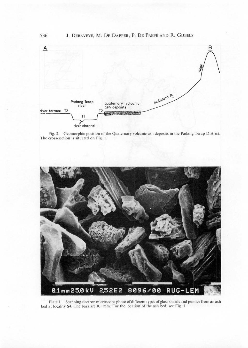
2 534 J. DEBAVEYE, M. DE DAPPER, P. DE' PAEPE AND R. GIJBELS pyroclastic rocks originated from the Toba volcano in north Sumatra and were mingled with local detrital material prior to final deposition. Soils developed on volcano ash deposits were first described in Malaysia by Leamy and Pantan (1966) and were later mapped by Soo (1968) and Law (1968) in Perak and Pahang respectively. The detailed analysis of a soil profile developed on volcanic ash in Perak was given by Paramananthan (1977). During the soil and geomorphological survey carried out in the Padang Terap District (De Dapper, 1981; Debaveye et al., 1983) the presence of volcanic ash deposits was established in Kedah. They were found extended over 238 ha. This is so far the most northerly position of the ashes observed on the peninsula. GEOMORPHOLOGICAL SETTING The rhyolitic ash deposits in Kedah occur scattered on both sides of the Padang Terap river lying between latitudes 6 17'N and 6 2l'N (Fig. 1). The observed thickness of the pyroclasticsmaterial is 1.2 m to more than 2 m. The bedrock in the area consists of Mesozoic sedimentary rocks of the Middle to Upper Triassic Semanggol Formation. The later includes interbedded shales and sandstones and locally contains interbeds and lenses of conglomerate and chert. The plain of the Padang Terap river has an elevation which ranges from I 5 to 50 m above sea-level. It is divided by a great number of parallel ridges, emerging from the surrounding upland and running almost perpendicular to the main drainage axes. Hence, the plain is compartmentalized and the main rivers break through the ridges by narrow watergaps which form local temporary base levels. A set of two river terraces (T 1 and T 2 ) occurs along the main river channels. T 1 is mostly cut-and-filled in T 2 -deposits. A short distance upstream the watergaps, due to the bunding effect of the latter, the younger T 1 -deposits can locally overlap the T 2 - deposits. The T 2 -terrace level belongs to a geomorphic surface that also comprises important pediments (P 2 ) which developed at the feet of the ridges and isolated low hills in between the ridges (Fig. 2). This geomorphic surface has been formed during drier climatic conditions than the ones prevailing at the present day (De Dapper and Debaveye, 1984). The volcanic ashes occur on flat terrain (0-1 %), on top of the T 2 -terrace and the toeslope of the P 2 -pediments. They never cover the T 1 -deposits. In the most upstream section of the Padang Terap river valley the pyroclastic material occurs at an elevation of 35 m a.s.l. and takes a position in between imperfectly to well drained old alluvial soils (T 2 ) and well drained young alluvial soils (T 1 ). In the lower section of the river valley the ashes are found at 28 m a.s.l. and are covered by poorly drained young alluvial soils (T 1 ) (Kg. Pisang). In the latter no soil profile development was observed. For more details on the geomorphology of the Padang Terap District one is referred to De Dapper and Debaveye (1986).
3
4
5
6
7
8
9
10
11
12
13
14
15
16
17
Continental Landscapes
 Continental Landscapes Landscape influenced by tectonics, climate & differential weathering Most landforms developed within the last 2 million years System moves toward an equilibrium Continental Landscapes
Practice Test Rocks and Minerals. Name. Page 1
 Name Practice Test Rocks and Minerals 1. Which rock would be the best source of the mineral garnet? A) basalt B) limestone C) schist D) slate 2. Which mineral is mined for its iron content? A) hematite
Practice 3rd Quarter Exam Page 1
 Name 1. Which characteristic would most likely remain constant when a limestone cobble is subjected to extensive abrasion? A) shape B) mass C) volume D) composition 2. Which activity demonstrates chemical
LAB 2 IDENTIFYING MATERIALS FOR MAKING SOILS: ROCK AND PARENT MATERIALS
 LAB 2 IDENTIFYING MATERIALS FOR MAKING SOILS: ROCK AND PARENT MATERIALS Learning outcomes The student is able to: 1. understand and identify rocks 2. understand and identify parent materials 3. recognize
Geology (Mellow) Hike, Santa Lucia Memorial Park February 16, I. Overview of Santa Lucia Range geology and tectonic history
 Hike, Santa Lucia Memorial Park February 16, I. Overview of Santa Lucia Range geology and tectonic history") Geology (Mellow) Hike, Santa Lucia Memorial Park February 16, 2015 I. Overview of Santa Lucia Range geology and tectonic history A. Basement Rocks 1. Salinian Block Rocks Sierra Nevada Type, continental
Geology (Mellow) Hike, Santa Lucia Memorial Park February 16, 2015 I. Overview of Santa Lucia Range geology and tectonic history A. Basement Rocks 1. Salinian Block Rocks Sierra Nevada Type, continental
Chapter 10. Chapter Rocks and the Rock Cycle. Rocks. Section 1 Rocks and the Rock Cycle
 Chapter 10 Rocks 1 Chapter 10 Section 1 Rocks and the Rock Cycle 2 10.1 Rocks and the Rock Cycle Magma is the parent material for all rocks. Once the magma cools and hardens, many changes can occur. Geology:
mountain rivers fixed channel boundaries (bedrock banks and bed) high transport capacity low storage input output
 high transport capacity low storage input output") mountain rivers fixed channel boundaries (bedrock banks and bed) high transport capacity low storage input output strong interaction between streams & hillslopes Sediment Budgets for Mountain Rivers Little
mountain rivers fixed channel boundaries (bedrock banks and bed) high transport capacity low storage input output strong interaction between streams & hillslopes Sediment Budgets for Mountain Rivers Little
Classification according to patent rock material/origin, soil distribution and orders
 Classification according to patent rock material/origin, soil distribution and orders Alluvial Soils Shales and Sandstone Soils Limestone Soils Chocolate Hills: Limestone formation Andesite and Basalt
International Journal of Modern Trends in Engineering and Research e-issn No.: , Date: April, 2016
 International Journal of Modern Trends in Engineering and Research www.ijmter.com e-issn No.:2349-9745, Date: 28-30 April, 2016 Landslide Hazard Management Maps for Settlements in Yelwandi River Basin,
GEOL FORENSIC GEOLOGY ROCK IDENTIFICATION
 GEOL.2150 - FORENSIC GEOLOGY ROCK IDENTIFICATION Name I. Introduction There are three basic types of rocks - igneous, sedimentary, and metamorphic: Igneous. Igneous rocks have solidified from molten matter
Name. 4. The diagram below shows a soil profile formed in an area of granite bedrock. Four different soil horizons, A, B, C, and D, are shown.
 Name 1. In the cross section of the hill shown below, which rock units are probably most resistant to weathering? 4. The diagram below shows a soil profile formed in an area of granite bedrock. Four different
Figure 2.1: Constituent Area
 2 The Region 2.1 CONSTITUENT AREA The National Capital Region includes NCT-Delhi, nine districts of Haryana, six districts of Uttar Pradesh and one district of Rajasthan. Total area of the region is 34,144
Determination of uplift rates of fluvial terraces across the Siwaliks Hills, Himalayas of central Nepal
 Determination of uplift rates of fluvial terraces across the Siwaliks Hills, Himalayas of central Nepal Martina Böhme Institute of Geology, University of Mining and Technology, Freiberg, Germany Abstract.
PALEOGEOGRAPHY of NYS. Definitions GEOLOGIC PROCESSES. Faulting. Folding 9/6/2012. TOPOGRAPHIC RELIEF MAP of NYS GRADATIONAL TECTONIC
 TOPOGRAPHIC RELIEF MAP of NYS PALEOGEOGRAPHY of NYS Prof. Anthony Grande AFG 2012 Definitions GEOLOGIC PROCESSES Geography: study of people living on the surface of the earth. Geology: the scientific study
Geologic History. Earth is very, very old
 Geologic History Earth is very, very old Earth s History The history of Earth and the ages of rocks can be investigated and understood by studying rocks and fossils. Evidence of ancient, often extinct
Page 1. Name:
 Name: 1) Which property would best distinguish sediment deposited by a river from sediment deposited by a glacier? thickness of sediment layers age of fossils found in the sediment mineral composition
Chapter 2. Wearing Down Landforms: Rivers and Ice. Physical Weathering
 Chapter 2 Wearing Down Landforms: Rivers and Ice Physical Weathering Weathering vs. Erosion Weathering is the breakdown of rock and minerals. Erosion is a two fold process that starts with 1) breakdown
Page 1. Name:
 Name: Questions 1 through 3 refer to the following: The diagrams below represent two rock outcrops found several miles apart in New York State. Individual rock layers are lettered, and fossils and rock
Water, geology, climate & soils: Sierra Nevada, Merced River & Central Valley connections
 Water, geology, climate & soils: Sierra Nevada, Merced River & Central Valley connections Geography & geology Merced River basin Climate & hydrology Soils & soil formation Roger Bales UC Merced Water,
(Refer Slide Time: 1:25)
") Earth Sciences for Civil Engineering Professor Javed N Malik Department of Earth Sciences Indian Institute of Technology Kanpur Module 2 Lecture No 10 Rock types and their Properties (Part-4) So welcome
Earth Sciences for Civil Engineering Professor Javed N Malik Department of Earth Sciences Indian Institute of Technology Kanpur Module 2 Lecture No 10 Rock types and their Properties (Part-4) So welcome
Landforms and Rock Structure
 Landforms and Rock Structure Rock Structure as a Landform Control Landforms of Horizontal Strata and Coastal Plains Landforms of Warped Rock Layers Landforms Developed on Other Land-Mass Types Landforms
LANDFORM REGIONS IN CANADA. Classroom Notes and Descriptions
 LANDFORM REGIONS IN CANADA Classroom Notes and Descriptions Landform Regions in Canada There are eight distinct landforms in Canada: Western Cordillera Region Interior Plains Canadian Shield Hudson Bay
Name Roy G Biv Page 1
 Name Roy G Biv Base your answers to questions 1 through 3 on the diagram below. The arrows show the direction in which sediment is being transported along the shoreline. A barrier beach has formed, creating
Cattaraugus Creek: A Story of Flowing Water and the Geology of the Channel It Flows Through Presentation to West Valley Citizen Task Force 4/27/16
 Cattaraugus Creek: A Story of Flowing Water and the Geology of the Channel It Flows Through Presentation to West Valley Citizen Task Force 4/27/16 Raymond C. Vaughan, Ph.D. What happens if you drop a
Quiz 1. 3) Which of the following planetary bodies has the least number of impact craters on its surface? A) Mercury B) Mars C) the Moon D) Earth
 Which of the following planetary bodies has the least number of impact craters on its surface? A) Mercury B) Mars C) the Moon D) Earth") Quiz 1 1) Earth's atmosphere is unique among the moons and planets in that A) it has a nitrogen (N2) rich atmosphere. B) it is rich in oxygen (O2) and nitrogen (N2). C) it is rich in carbon dioxide because
Quiz 1 1) Earth's atmosphere is unique among the moons and planets in that A) it has a nitrogen (N2) rich atmosphere. B) it is rich in oxygen (O2) and nitrogen (N2). C) it is rich in carbon dioxide because
A Sedimentary Rock is..
 Sedimentary Rocks A Sedimentary Rock is.. rock formed from the lithification or crystallization of: 1. Minerals in solution 2. Organic remains 3. Materials produced by living things (biochemical) 4. Clastic
Custom Soil Resource Report Soil Map
 77 35' 22'' W Custom Soil Resource Report Soil Map 77 35' 0'' W 282170 282220 282270 282320 282370 282420 282470 282520 282570 282620 40 59' 2'' N 40 58' 52'' N 4539900 4539950 4540000 4540050 4540100
Chapter 3 Sedimentation of clay minerals
 Chapter 3 Sedimentation of clay minerals 3.1 Clay sedimentation on land 3.2 From land to sea 3.3 Clay sedimentation in the sea 1 3.1 Clay sedimentation on land Deserts Glaciers Rivers Lacustrine 2 University
This slide show is intended to help you understand important types of rocks.
 Rocks Mrs. Comer This slide show is intended to help you understand important types of rocks. The diagram in the next slide represents the ROCK CYCLE a scheme that represents the processes of continuous
INTRODUCTION. Climate
 INTRODUCTION Climate Landslides are serious natural disasters in many parts of the world. Since the past 30 years, rainfall triggered landslides and debris flows had been one of the natural disasters of
COMPOSITIONAL TERMS: FELSIC : light colored INTERMEDIATE : medium shades MAFIC : dark colored ULTRAMAFIC : rare (composition of the mantle)
") GEOLOGY 306 Laboratory NAME: Instructor: TERRY J. BOROUGHS SECTION: Common Rocks (Chapter 2) For this assignment, you will require: a streak plate, glass plate, magnet, dilute hydrochloric (HCl) acid,
GEOLOGY 306 Laboratory NAME: Instructor: TERRY J. BOROUGHS SECTION: Common Rocks (Chapter 2) For this assignment, you will require: a streak plate, glass plate, magnet, dilute hydrochloric (HCl) acid,
Igneous petrology EOSC 321 Laboratory 8: Intermediate and Felsic Volcanic Rocks. Pyroclastic Rocks
 321 Lab 8 Instructor: L. Porritt - 1 - Igneous petrology EOSC 321 Laboratory 8: Intermediate and Felsic Volcanic Rocks. Pyroclastic Rocks Learning Goals. After this Lab, you should be able: Identify fine-grained
Name HW - Landscapes
 Name HW - Landscapes 1. New York s Tug Hill landscape region is classified as a plateau because this region has a A) high elevation with distorted bedrock B) high elevation with nearly horizontal layers
Geohistory Review. Things you need to know:
 Geohistory Review Things you need to know: a) The earth and the solar system are 4.5 billion years old (4.5 X 10 9 ) b) Law of original horizontality: Sedimentary rock layers are always deposited as horizontal
BUREAU OF MINERAL RESOURCES GEOLOGY AND GEOPHYSICS
 COMMONWEALTH OF AUSTRALIA DEPARTMENT OF NATIONAL DEVELOPMENT BUREAU OF MINERAL RESOURCES GEOLOGY AND GEOPHYSICS RECORDS: 1 9 67/77 PHOTO-INTERPRETATION OF BURKETOWN 1:250,000 SCALE SHEET QUEENSLAND. by
NOA ASSESSMENT HARRIS QUARRY MENDOCINO COUNTY, CALIFORNIA TABLE OF CONTENTS
 NOA ASSESSMENT HARRIS QUARRY MENDOCINO COUNTY, CALIFORNIA TABLE OF CONTENTS Introduction... 1 Scope of Services... 1 Project Location and Description... 1 Geologic Setting... 1 Regional Geology... 1 Site
1.0 Introduction 1.1 Geographic Location 1.2 Topography 1.3 Climate and Rainfall 1.4 Geology and Hydrogeology 1.5 Water Availability 1.
 1.0 1.1 Geographic Location 1.2 Topography 1.3 Climate and Rainfall 1.4 Geology and Hydrogeology 1.5 Water Availability 1.6 Demography 1.0 1.1 Geographic Location St. Lucia forms part of an archipelago
 Page 1 of 9 Name: Base your answer to the question on the diagram below. The arrows show the direction in which sediment is being transported along the shoreline. A barrier beach has formed, creating a
Erosional Features. What processes shaped this landscape?
 Have you ever looked at the land around you and wondered what processes shaped what you see? Perhaps you see mountains, valleys, rivers, or canyons. Do you know how long these geologic features have been
PROBLEMS OF CLASSIFYING SOILS WITH SULFIDIC HORIZONS IN PENINSULAR MALAYS IA
 PROBLEMS OF CLASSIFYING SOILS WITH SULFIDIC HORIZONS IN PENINSULAR MALAYS IA S. Paramananthan Department of Agriculture Peninsular Malaysia, and B. Gopinathan Malaysian Agricultural Research and Development
Sedimentary Rocks. Rocks made of bits & pieces of other rocks.
 Sedimentary Rocks Rocks made of bits & pieces of other rocks. Sedimentary Rocks Igneous rocks are the most common rocks on Earth, but because most of them exist below the surface you might not have seen
Engineering Geology ECIV 2204
 Engineering Geology ECIV 2204 Instructor : Dr. Jehad Hamad 2017-2016 Chapter (3) Igneous Rocks Chapter 3: Rocks: Materials of the Solid Earth Igneous Rocks Chapter 3: Rocks: Materials of the Solid Earth
Directed Reading. Section: Rocks and the Rock Cycle. made of a. inorganic matter. b. solid organic matter. c. liquid organic matter. d. chemicals.
 Skills Worksheet Directed Reading Section: Rocks and the Rock Cycle 1. The solid part of Earth is made up of material called a. glacial ice. b. lava. c. rock. d. wood. 2. Rock can be a collection of one
SOILS RELATIVE TO GEOLOGY AND LANDFORMS IN WALNUT GULCH EXPERIMENTAL WATERSHED, ARIZONA, USA. W. R. Osterkamp, D. J. Breckenfeld, and J.J.
 SOILS RELATIVE TO GEOLOGY AND LANDFORMS IN WALNUT GULCH EXPERIMENTAL WATERSHED, ARIZONA, USA W. R. Osterkamp, D. J. Breckenfeld, and J.J. Stone ABSTRACT Soils of the Walnut Gulch Experimental Watershed
The future of the Lowland Belizean Savannas?.
 The future of the Lowland Belizean Savannas?. Using cluster analysis to explore multivariate spatial patterns in savanna soils PETER FURLEY & SARAH BEADLE UK Belize association 15 th November 2014 Outline
2.2.7 Backbarrier flats
 FIGURE 24. VERTICAL PHOTOGRAPH SHOWING THE DEVELOPMENT OF SMALL PARABOLIC DUNES FROM BLOWOUTS IN A LARGE RELICT FOREDUNE NORTHWEST OF HUNTER'S CREEK. PHOTOGRAPH COURTESY OF CAR'T'ER HOLT HARVEY FORESTS
Weathering, Erosion, Deposition, and Landscape Development
 Weathering, Erosion, Deposition, and Landscape Development I. Weathering - the breakdown of rocks into smaller particles, also called sediments, by natural processes. Weathering is further divided into
Erosion and Deposition
 Erosion and Deposition The Erosion-Deposition Process What do you think? Read the two statements below and decide whether you agree or disagree with them. Place an A in the Before column if you agree with
8 th Earth Science Chapter 4 Rocks Name Section 1 The Rock Cycle:
 8 th Earth Science Chapter 4 Rocks Name Section 1 The Rock Cycle: Most rock used for stone contains one or more common minerals, called rock-forming minerals, such as, feldspar,, or. When you look closely,
RIVERS, GROUNDWATER, AND GLACIERS
 RIVERS, GROUNDWATER, AND GLACIERS Delta A fan-shaped deposit that forms when a river flows into a quiet or large body of water, such as a lake, an ocean, or an inland sea. Alluvial Fan A sloping triangle
PENNSYLVANIA. Ordinary processes at Earth's surface and just below it cause rocks to change and soils to form. Page 1 of 3. S8.A.1.1.
 Know: Understand: Do: S8.D.1.1.1 -- Essential Explain the rock cycle as changes in the solid earth and rock types found in Pennsylvania (igneous - granite, basalt, obsidian, pumice, ; sedimentary - limestone,
Section I: Multiple Choice Select the best answer to each question. Mark your final answer on the answer sheet. (1 pt each)
") Sedimentary Rocks & Surface Processes Quest Name: Earth Science 2013 Block: Date: Section I: Multiple Choice Select the best answer to each question. Mark your final answer on the answer sheet. (1 pt each)
Sedimentary Rocks & Surface Processes Quest Name: Earth Science 2013 Block: Date: Section I: Multiple Choice Select the best answer to each question. Mark your final answer on the answer sheet. (1 pt each)
Geology and hydrology of Tuaran
 Allnllal Geological Conference '96 ~~~~~ Jllne 8-9,1996, [(ota [(illaballl, Sabah Geology and hydrology of Tuaran MAJEED M. FAISAL, SHARIFF A.K. OMANG AND SANUDIN HJ. TAHIR University Malaysia Sabah Km
Exploring Geology Chapter 9 Geologic Time
 Exploring Geology Chapter 9 Geologic Time Copyright The McGraw-Hill Companies, Inc. Permission required for reproduction or display. Chapter 9: Geologic Time Stratigraphic Principles Relative Age Dating
Chapter 2. Regional Landscapes and the Hydrologic Cycle
 Chapter 2. Regional Landscapes and the Hydrologic Cycle W. Lee Daniels Department of Crop and Soil Environmental Sciences, Virginia Tech Table of Contents Introduction... 23 Soils and landscapes of the
Rock Identification. invisible rhyolite andesite basalt komatiite. visible granite diorite gabbro peridotite
 Rock Identification The samples in this lab are arranged into four groups: igneous, sedimentary, metamorphic, and unknown. Study the igneous, sedimentary, and metamorphic collections to get an idea of
Page 1. Name:
 Name: 1) Which event is the best example of erosion? dissolving of rock particles on a limestone gravestone by acid rain breaking apart of shale as a result of water freezing in a crack rolling of a pebble
A Sedimentary Rock is..
 Sedimentary Rocks A Sedimentary Rock is.. rock formed from the lithification or crystallization of: 1. Minerals in solution 2. Organic remains 3. Materials produced by living things (biochemical) 4. Clastic
Geomorphological and geological features of the collapsing landslides induced by the 2009 Padang earthquake
 Geomorphological and geological features of the collapsing landslides induced by the 2009 Padang earthquake Maho Nakano (1), Masahiro Chigira (2), ChounSian Lim (3), Sumaryono gajam (4) (1) CTI Engineering
Soils, Hydrogeology, and Aquifer Properties. Philip B. Bedient 2006 Rice University
 Soils, Hydrogeology, and Aquifer Properties Philip B. Bedient 2006 Rice University Charbeneau, 2000. Basin Hydrologic Cycle Global Water Supply Distribution 3% of earth s water is fresh - 97% oceans 1%
Review - Unit 2 - Rocks and Minerals
 Review - Unit 2 - Rocks and Minerals Base your answers to questions 1 and 2 on the diagram below, which shows the results of three different physical tests, A, B, and C, that were performed on a mineral.
GEOLOGICAL FEATURES OF THE BADGER SPRINGS TRAIL FOR HIKERS Rev. 3,
 GEOLOGICAL FEATURES OF THE BADGER SPRINGS TRAIL FOR HIKERS Rev. 3, 12-3-02 http://ensayoes.com/docs/176/index-2111121.html Trail location The Badger Springs trail is just a short distance North of the
EROSIONAL FEATURES. reflect
 reflect Have you ever looked at the land around you and wondered what processes shaped what you see? Perhaps you see mountains, valleys, rivers, or canyons. Do you know how long these geologic features
The Geology of Pacific Northwest Rocks & Minerals Activity 1: Geologic Time
 Name: Age: I. Introduction There are two types of geologic time, relative and absolute. In the case of relative time geologic events are arranged in their order of occurrence. No attempt is made to determine
GEOPHYSICS GRAVITY DATA COVERAGE
 GEOPHYSICS DATA COVERAGE The Mudgee-Gulgong district lies within the Dubbo 1:250,000 sheet area. This area is now covered by high res_olution gravity, magnetic and radiometric data. The aeromagnetic and
Social Studies 9 UNIT 2 GEOGRAPHIC INFLUENCES ON IDENTITY: PLACE AND PEOPLE
 Social Studies 9 UNIT 2 GEOGRAPHIC INFLUENCES ON IDENTITY: PLACE AND PEOPLE The Structure of the Earth To understand the forces that create Canada's physical landscape we must understand the structure
Landforms. Why does the land look like it does? 1. Controlled by water 2. Controlled by the rocks
 Landforms Why does the land look like it does? 1. Controlled by water 2. Controlled by the rocks Landforms Made by Running Water Stream erosion The evolution of a river system Entrenched meanders Fluvial
[Penumaka, 7(1): January-March 2017] ISSN Impact Factor
![[Penumaka, 7(1): January-March 2017] ISSN Impact Factor](/thumbs/95/124653515.jpg "[Penumaka, 7(1): January-March 2017] ISSN Impact Factor") INTERNATIONAL JOURNAL OF ENGINEERING SCIENCES &MANAGEMENT HYDROGEOMORPHOLOGY OF CHEVELLA BASIN, RANGA REDDY DISTRICT, TELANGANA STATE Penumaka Ramesh* 1 & Podila Sankara Pitchaiah 2 * 1&2 Department of
INTERNATIONAL JOURNAL OF ENGINEERING SCIENCES &MANAGEMENT HYDROGEOMORPHOLOGY OF CHEVELLA BASIN, RANGA REDDY DISTRICT, TELANGANA STATE Penumaka Ramesh* 1 & Podila Sankara Pitchaiah 2 * 1&2 Department of
Colluvial debris: Rocks that have fallen down hills. Types of Parent Material
 Weathered Rocks from the lithosphere are the parent materials for soils Nature of the parent material will greatly influence time it takes to make soil and the nature of the soil that is formed Types of
Unit 2 Exam: Rocks & Minerals
 Name: Date: 1. Base your answer(s) to the following question(s) on the 2001 edition of the Earth Science Reference Tables, the map and cross section below, and your knowledge of Earth science. The shaded
Geomorphology for Engineers
 Geomorphology for Engineers Edited by P. G. Fookes, E. M. Lee and G. Milligan Whittles Publishing CRC PRESS Contents Foreword Preface Dedication Biographies 1. Introduction to Engineering Geomorphology
Geology of Quesnel and Stikine terranes and associated porphyry deposits. Jim Logan Paul Schiarizza
 Geology of Quesnel and Stikine terranes and associated porphyry deposits Jim Logan Paul Schiarizza Quesnel and Stikine terranes Major cordilleran terranes characterized by similar Late Triassic Early Jurassic
Erosion Surface Water. moving, transporting, and depositing sediment.
 + Erosion Surface Water moving, transporting, and depositing sediment. + Surface Water 2 Water from rainfall can hit Earth s surface and do a number of things: Slowly soak into the ground: Infiltration
Name Class Date. Study Guide for 7 th Grade Final Exam (Semester One)
") Name Class Date Study Guide for 7 th Grade Final Exam (Semester One) 1. What are the steps of the scientific method? Define the problem or question Form a hypothesis (MUST BE TESTABLE) o (identify variables)
Name Class Date Study Guide for 7 th Grade Final Exam (Semester One) 1. What are the steps of the scientific method? Define the problem or question Form a hypothesis (MUST BE TESTABLE) o (identify variables)
Page 1. Name:
 Name: 1) What is the approximate density of a mineral with a mass of 262.2 grams that displaces 46 cubic centimeters of water? A) 6.1 g/cm 3 C) 1.8 g/cm 3 B) 5.7 g/cm 3 D) 12.2 g/cm 3 2) In which two Earth
Edinburgh Research Explorer
 Edinburgh Research Explorer GEOMORPHOLOGY Rivers split as mountains grow Citation for published version: Attal, M 2009, 'GEOMORPHOLOGY Rivers split as mountains grow' Nature Geoscience, vol. 2, no. 11,
EROSION, DEPOSITION AND SEDIMENTARY ROCKS. Reading: Earth Science Tarbuck and Lutgens Chapter 5: pages Chapter 3: pages 52-54, 61-69
 EROSION, DEPOSITION AND SEDIMENTARY ROCKS Reading: Earth Science Tarbuck and Lutgens Chapter 5: pages 124-133 Chapter 3: pages 52-54, 61-69 Base Level Resistant bed Resistant bed creates a local base level
ATTACHMENT Q PALEONTOLOGICAL RESOURCES REPORT
 ATTACHMENT Q PALEONTOLOGICAL RESOURCES REPORT LaRamie Soils Service, Inc. 217B Grand Avenue, Suite 1 P.O. Box 255 Laramie, WY 82073 geomorph@laramiesoils.com PALEONTOLOGICAL EVALUATION LANCASTER ENERGY
HW #2 Landscape Travel from A to B 12,
 HW #2 Landscape 2016 Section: Name: ate: 1. ase your answer(s) to the following question(s) on the map below, which represents two bridges that cross the Green River. Letters,, and represent locations
Term 1 final review ES
 Name: Date: 1. t what approximate altitude in the atmosphere can stratospheric ozone be found?. 10 km. 30 km. 70 km D. 100 km 2. What percentage of Earth s history represents human existence?. less than
Surface Water and Stream Development
 Surface Water and Stream Development Surface Water The moment a raindrop falls to earth it begins its return to the sea. Once water reaches Earth s surface it may evaporate back into the atmosphere, soak
Version 1 Page 1 Barnard/George/Ward
 The Great Mineral & Rock Test 1. Base your answer to the following question on the table below which provides information about the crystal sizes and the mineral compositions of four igneous rocks, A,
UNIT 3 GEOLOGY VOCABULARY FLASHCARDS THESE KEY VOCABULARY WORDS AND PHRASES APPEAR ON THE UNIT 3 CBA
 UNIT 3 GEOLOGY VOCABULARY FLASHCARDS THESE KEY VOCABULARY WORDS AND PHRASES APPEAR ON THE UNIT 3 CBA A map that shows Earth s Topographic Map surface topography, which is Earth s shape and features Contour
Geologic History Unit Notes. Relative age - general age statement like older, younger more recent
 Geologic History Unit Notes Relative age - general age statement like older, younger more recent Absolute age - specific age like 4,600 million years old Fundamental Principles of Relative Dating 1. Uniformitarianism
GLY 155 Introduction to Physical Geology, W. Altermann. Grotzinger Jordan. Understanding Earth. Sixth Edition
 Grotzinger Jordan Understanding Earth Sixth Edition Chapter 4: IGNEOUS ROCKS Solids from Melts 2011 by W. H. Freeman and Company Chapter 4: Igneous Rocks: Solids from Melts 1 About Igneous Rocks Igneous
23/9/2013 ENGINEERING GEOLOGY. Chapter 2: Rock classification:
 ENGINEERING GEOLOGY Chapter 2: Rock classification: ENGINEERING GEOLOGY Chapter 1.0: Introduction to engineering geology Chapter 2.0: Rock classification Igneous rocks Sedimentary rocks Metamorphic rocks
Glacial Erosion Polished on front side Glacial striations (scratches) on top
 on top") St Mary s Cemetery Glacial Erosion Polished on front side Glacial striations (scratches) on top Weathering Water channel in the rock mechanical weathering Some rocks eroding faster than others mechanical
St Mary s Cemetery Glacial Erosion Polished on front side Glacial striations (scratches) on top Weathering Water channel in the rock mechanical weathering Some rocks eroding faster than others mechanical
2. PHYSICAL SETTING FINAL GROUNDWATER MANAGEMENT PLAN. 2.1 Topography. 2.2 Climate
 FINAL GROUNDWATER MANAGEMENT PLAN 2. PHYSICAL SETTING Lassen County is a topographically diverse area at the confluence of the Cascade Range, Modoc Plateau, Sierra Nevada and Basin and Range geologic provinces.
Quiz Five (9:30-9:35 AM)
") Quiz Five (9:30-9:35 AM) UNIVERSITY OF SOUTH ALABAMA GY 111: Physical Geology Lecture 10: Intrusive Igneous Rocks Instructor: Dr. Douglas W. Haywick Last Time 1) Pyro-what? (air fall volcanic rocks) 2)
Quiz Five (9:30-9:35 AM) UNIVERSITY OF SOUTH ALABAMA GY 111: Physical Geology Lecture 10: Intrusive Igneous Rocks Instructor: Dr. Douglas W. Haywick Last Time 1) Pyro-what? (air fall volcanic rocks) 2)
Sediment and sedimentary rocks Sediment
 Sediment and sedimentary rocks Sediment From sediments to sedimentary rocks (transportation, deposition, preservation and lithification) Types of sedimentary rocks (clastic, chemical and organic) Sedimentary
Indian Statistical Institute Junior Research Fellowship in Geology, Entrance Examination 2016
 Indian Statistical Institute Junior Research Fellowship in Geology, Entrance Examination 2016 BOOKLET No. Afternoon TEST CODE: GEB Time: 2 hours Part I - one question 1 X 25 = 25 Part II five questions
Page 1. Weathering & Erosion by Mass Wasting Pre-Test. Name:
 Weathering & Erosion by Mass Wasting Pre-Test 3048-1 - Page 1 Name: 1) As a particle of sediment in a stream breaks into several smaller pieces, the rate of weathering of the sediment will A) increase
Igneous Rock Classification, Processes and Identification Physical Geology GEOL 100
 Igneous Rock Classification, Processes and Identification Physical Geology GEOL 100 Ray Rector - Instructor Major Concepts 1) Igneous rocks form directly from the crystallization of a magma or lava 2)
The structure of the Earth and how its motion creates the seasons. The landforms of the earth and the forces that shape the land.
 The structure of the Earth and how its motion creates the seasons. The landforms of the earth and the forces that shape the land. The role of wind and water in creating climate. The different climate and
9/4/2015. Feldspars White, pink, variable Clays White perfect Quartz Colourless, white, red, None
 ENGINEERING GEOLOGY Chapter 1.0: Introduction to engineering geology Chapter 2.0: Rock classification Igneous rocks Sedimentary rocks Metamorphic rocks Chapter 3.0: Weathering & soils Chapter 4.0: Geological
Rocks. Types of Rocks
 Rocks Rocks are the most common material on Earth. They are naturally occurring aggregates of one or more minerals. 1 Igneous rocks, Types of Rocks Sedimentary rocks and Metamorphic rocks. 2 1 3 4 2 IGNEOUS
Geologic Trips San Francisco and the Bay Area
 Excerpt from Geologic Trips San Francisco and the Bay Area by Ted Konigsmark ISBN 0-9661316-4-9 GeoPress All rights reserved. No part of this book may be reproduced without written permission in writing,
The Geology of Sebago Lake State Park
 Maine Geologic Facts and Localities September, 2002 43 55 17.46 N, 70 34 13.07 W Text by Robert Johnston, Department of Agriculture, Conservation & Forestry 1 Map by Robert Johnston Introduction Sebago
Before the 1700 s, scientists thought that the Earth was only 6,000 years old. This mindset was based on biblical references.
 Before the 1700 s, scientists thought that the Earth was only 6,000 years old. This mindset was based on biblical references. However, as scientists began to better understand the processes that shape
Pre-Lab Reading Questions ES202
 ES202 The are designed to encourage students to read lab material prior to attending class during any given week. Reading the weekly lab prior to attending class will result in better grade performance