GEOPHYSICS GRAVITY DATA COVERAGE
|
|
|
- Elvin Cannon
- 5 years ago
- Views:
Transcription
1 GEOPHYSICS DATA COVERAGE The Mudgee-Gulgong district lies within the Dubbo 1:250,000 sheet area. This area is now covered by high res_olution gravity, magnetic and radiometric data. The aeromagnetic and radiometric surveys were flown in 1991 by the Australian Geological Survey Organisation (AGSO) using flight line spacings of 400m. However to improve resolution the Department of Mineral Resources provided additional fimding for 250m interline spacing over parts of the Molong and Capertee Zones including the central part of the Mudgee-Gulgong area. The average mean terrain clearance was 100 m. The gravity data acquired by AGSO in 1973 using an approximate square grid of 11 km and was infilled by the Department of Mineral Resources to an approximate grid spacing of 4.0 km. Several transforms were applied to the grided magnetic data including Reduction to the Pole (RTP) and RTP first vertical derivative. Image processing was applied to the grided data to produce final pseudocolour and greyscale products of Total Magnetic Intensity (TMI) magnetics, RTP-TMI magnetics and their first and second vertical derivatives. The grided K-U-Th radiometric data was contrast enhanced and combined to produce RGB colour composite images. Interpretation of the magnetic and radiometric data was undertaken with images produced at a scale of 1:50,000. The residual gravity data was illuminated with an artificial sun from the east to enhance the north-south structural grain. GRAVITY Fig. 10 is and image of the residual gravity data for the Mudgee-Gulgong region. The image shows a major continuous gravity ridge extending from south of Ilford to Gulgong. Outcropping Ordovician volcanic rocks such as the Burranah Formation and
2 the Cudgegong Volcanics, are associated with gravity highs along this ridge while elsewhere along the gravity ridge the response is more subdued. To the west and northwest of Gulgong the gravity ridge becomes a broad area with a high gravity response. This area is located beneath the fill of the Hill End Trough and suggests that Ordovician volcanics may form a considerable part of the basement of this area. The three Carboniferous granites, The Gulgong Granite, the Ulan Granite and the Home Rule Granite are all represented by well-defined gravity lows. The northwest trending domains of gravity highs to the northeast of the Burranah Formation are located under Permian cover of the Sydney Basin but are thought to be expressions of the Early Permian Rylstone Volcanics. MAGNETICS. Geological mapping and interpretation of the Mudgee-Gulgong district was greatly aided by the magnetic data, particularly the first derivative pseudocolour TMI image. This data shows major and subtle magnetic units and linears, allowing interpretation at a regional as well as a local scale. Outcrop magnetic susceptibilities were collected during mapping to aid interpretation (Table 1). TABLE 1. Ranges of Outcrop Magnetic Susceptibilities Unit Rock Type Range (St units x lo5) Burranah Formation Monzodiorite Lava Volcanic breccia Volcaniclastic sandstone, siltstone Early Devonian Diorite Fresh diorite Altered diorite Carwell Creek Formation Siltstone Gulgong Granite Granite

3 I I! I Scale 1 :400,000 lma e of residual gravity for i the RI udgee-gulgong district Fig. 10
4
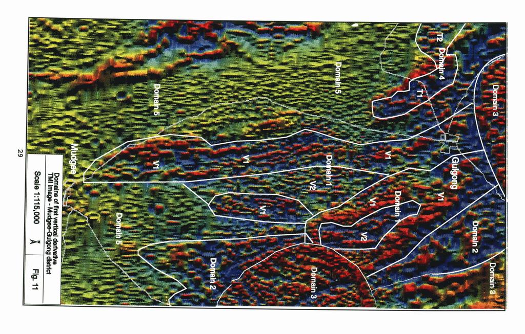
5 Fig. 11 is a first vertical derivative TMI pseudocolour image of the Mudgee-Gulgong district. The image has been divided into five main domains based on the intensity and character of the magnetic response. Domain I Domain 1 incorporates the Burranah Formation. It is characterised by generally linear, moderate to high intensity anomalies within a background area of generally low intensity response. Within this domain there are two principal subdomains termed V1 and V2. Subdomain V1 has a variable moderate to high response and subdomain V2 has a variable but generally low to moderate response. Domain V1 consists dominantly of primary volcanic rocks and breccias while domain V2 is composed dominantly of volcaniclastic rocks, small intrusions and sediments. Subdomain V1 forms a north-south-trending belt on the western side of the Burranah Formation and outlines a previously u~ecognised extension of The Burranah Formation to the east of Gulgong. The western subdomain is fault bounded and has several narrow magnetic units that have north-nortwesterly trends. Offsets on many of these units have been interpreted as faults that have dextral senses of movement. The subdomain area east of Gulgong is interpreted to form a south-plunging syncline under a thin cover of Quaternary alluvium. Subdomain V1 effectively surrounds most of V2. Subdomain V2 has numerous north-south trending narrow magnetic units which often form fold closures. Several faults are interpreted from within this domain. The Mount Galambine, Magpie Hill and Home Rule Faults are represented as narrow linear corridors of low magnetic intensity that also form boundaries, in part, to the V1 and V2 subdomains. Several late, northeast trending faults cut across both the V1 and V2 subdomains and have both dextral and sinistral senses of movement.
6 Domain 2 Domain 2 is characterised by groups of small, circular, coalescing high intensity anomalies. The southern area corresponds to the Eurundery Anticline that contains rocks of the Coomber Formation and Dungaree Volcanics. The northern area is entirely under Cainozoic cover and may represent additional occurrences of these units. Domain 3 Domain 3 comprises three distinctive broadly circular high intensity magnetic areas that are interpreted as three separate granitoids referred to earlier as the Gulgong Granite, the Ulan Granite and the Home Rule Granite. The Gulgong Granite and the Home Rule Granite have a similar high magnetic response but the Ulan Granite is less well defined. The Ulan Granite and the Home Rule Granite are transected by several narrow late stage dykes. A strong linear magnetic low trends southwesterly across the southern edge of the Gulgong Granite. Domain 4 Domain 4 is located to the west of Gulgong and comprises an area of generally low magnetic response. The domain defines the main area of Tertiary basaltic lava flows and can be divided into two subdomains that represent separate flows. Subdomain TI is a northwest trending area about 7 km long by 1 km wide with a generally smooth low magnetic intensity core surrounded by a high magnetic intensity rim. This subdomain crosscuts the smaller subdomain T2 immediately to its west that has a slightly higher overall magnetic intensity. Subdomain T2 represents a slightly older basaltic lava flow.
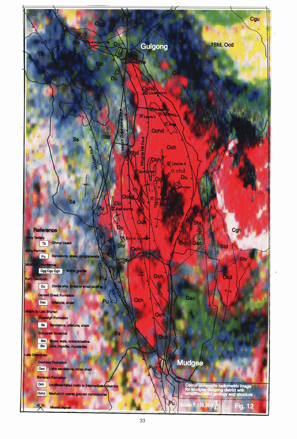
7 Domain 5 Domain 5 comprises the remainder of the study area and is characterised by generally low magnetic intensity responses. The domain includes units of the Chesleigh Formation, Carwell Creek Formation and the Dungaree Volcanics. In the west of the domain area there are several narrow, linear, high magnetic intensity anomalies that outline a number of broad, open folds. These folds are located within the upper volcanic unit of the Chesleigh Formation in the Hill End Trough and help to define the structural character of this part of the district. The northern extension of the Mudgee Fault can also be traced through this domain. It is represented as a very narrow linear zone of subtle low magnetic intensity areas that trend north nortwesterly through the district towards the base of the Chesleigh Formation. RADIOMETRICS In contrast to magnetic data, radiometric data is a response from probably no more than the top 40 cm to 50 cm of the surficial material. In areas of outcrop, the radiometric response is a reflection of the radiogenic qualities of the outcrop, but this response can become progressively more modified as surficial processes become dominant. In areas of residuum or even colluviurn, the response may still reflect the nature of bedrock, however in areas of deep weathering, deep alluvium, or areas modified by agricultural activities, the original radiometric response can be greatly modified. Despite the obvious need for caution in its interpretation, the radiometric data has been a valuable guide in discriminating the main geological units in the study area. The radiometric image shown in Fig. 12 is an rgb (red, green, blue) colour composite image of the potassium (K), thorium (Th) and uranium (U) datasets with the simplified
8
9 geology. The image has been contrast enhanced using histogram equalisation to maximise the discrimination between geological units. The Burranah rmd Coomber Formatiom The Burranah Formation constitutes the region of highest relief within the study area. It is dissected by numerous, essentially radially arranged streams that drain mostly away 6om the area to leave residual soils and minor areas of outcrop. This setting is reflected in the radiometric response that is a strong and mostly uniform red that reflects the potassic (shoshonitic) nature of the volcanic rocks of this formation. Where areas of internal drainage are developed, the radiometric response becomes much darker and almost black eg, in the area to the west of the Home Rule Granite. Because of the uniform response from the Burranah Formation there is little structural information that can be interpreted fiom the data. Areas of internal drainage are developed to the west of the Mount Galambine Fault and east of the Magpie Hill Fault. The Coomber Formation crops out in the core of the Eumndury Anticline along with the Dungaree Volcanics. Outcrop is poor throughout the area and residual soils are well developed. The Coomber Formation has a similar red (high K) response to that of the Burranah Formation and this is probably a reflection of the feldspathic nature of the sandstones which dominate much of this unit. Dungaree Volcanics In areas of reasonable outcrop the Dungaree Volcanics have a mixed pinkish-red (high K, low Th, Low U) and white (low K, Low Th, Low U) radiometric response. The response contrasts with the more uniform add darker red response from the Burranah Formation and Coomber Formation and the characteristic yellow and green response
10 from the Lower Fhesleigh Formation. To the southwest of Gulgong this response is almost completely modiied by the green (Th) response from Quaternary alluvium. Chesleigh Formation In the area to the west of Mudgee, the basal section of the Chesleigh Formation displays the yellow and green (low K, high Th, low U) radiometric response typical of many sedimentary units. To the west the Chesleigh Formation develops a more red (high K) response as volcanics become dominant over sediment. Canvell Creek Formation The Carwell Creek Formation is a poorly outcropping unit in an area of low relief. The unit has a mottled green and blue response (high Th, high U, low K) north of Mudgee but the response changes to a mottled pink, blue and white in the Mudgee area where soils developed on the unit are extensively cultivated and improved. The response from the northern area is more typical of a sediment response and probably more representative of this unit. Cmbon~erous Granites The Home Rule Granite comprises an area of both red and white radiometric response. The red response is typical of many of the I-type granites in the Lachlan Fold Belt and is developed over areas of low relief with little or no outcrop. The white area ( low K, low Th, low U) is developed over the area of highest relief and may represent an early phase of the granite or alteration. The radiometric response from the Gulgong Granite is largely masked by the blue and black response from younger units while the response from the Ulan Granite is strongly
11 yellow and green, indicative of a relatively high thorium, low potassium, and low uranium composition. An area of colluvium and alluvium developed to the southwest of the Ulan Granite has a similar radiometric response to the Ulan Granite from which it was probably sourced. Permian Sediments and Tertiary Basalt Pemian sediments and Tertiary basalts crop out to the west and southwest of Gulgong. The radiometric response in this area consists of a mottled blue and white response (high U) from the Permian sediments that becomes a mottled blue and black response (high K, high Th, high U) from areas of Tertiary basalt. The mottled blue and black response is also present to the north and northeast of Gulgong and suggests the presence of additional Tertiary basalt in this area under a very thin cover of Quaternary alluvium.
REGIONAL GEOLOGICAL SE'ITING
 REGIONAL GEOLOGICAL SE'ITING TECTONIC SE'ITING The Mudgee-Gulgong district is located in the exposed northeastern margin of the Lachlan Fold Belt in central New South Wales and occurs mostly within the
3. GEOLOGY. 3.1 Introduction. 3.2 Results and Discussion Regional Geology Surficial Geology Mine Study Area
 3. GEOLOGY 3.1 Introduction This chapter discusses the baseline study of the geology and mineralization characteristics of the mine study area. The study consolidates existing geological data and exploration
ASX Company Announcement
 ASX Company Announcement Yellow Rock Resources ACN: 116 221 740 35 Great Eastern Highway Rivervale WA 6103 Telephone: (08) 9361 5400 Facsimile: (08) 9361 5900 Email: info@aurium.com.au Companies Announcement
OZ SEEBASE TM. Datasets. Digital Elevation Model
 Digital Elevation Model 10 Digital Elevation Models (DEM s) often show the youngest structures, and any active geological structures. They are widely used for neotectonic analysis. The composition of eroding
Geological & Geophysical Interpretation of ZTEM EM and Magnetic Survey. Kemess Project, BC. for AuRico Metals Inc. September, 2016 Nicole Pendrigh
 Geological & Geophysical Interpretation of ZTEM EM and Magnetic Survey Kemess Project, BC for AuRico Metals Inc. September, 2016 Nicole Pendrigh SUMMARY REPORT Regional setting Located in North central
Mine Scale Constrained Geophysical Inversion; A Case Study at the Darlot-Centenary Gold Mine
 Page 1 Mine Scale Constrained Geophysical Inversion; A Case Study at the Darlot-Centenary Gold Mine Sarah Monoury, SRK Consulting, Ben Jupp, SRK Consulting and Andrew Foley, Gold Fields This article was
Beneath the sand of the Tanami Desert
 Beneath the sand of the Tanami Desert ARGA 2018, Wallaroo, SA Nadir de Souza Kovacs Ngururrpa program The program area covers the traditional land of the Parna Ngururrpa People in a remote part of the
For personal use only
 VICTORIAN PORPHYRY COPPER GOLD TENEMENTS GRANTED ASX ANNOUNCEMENT 13 AUGUST 2013 Mantle Mining Corporation Limited (ASX: MNM) is pleased to report that three exploration licences highly prospective for
Euler Deconvolution Technique for Gravity Survey
 Journal of Applied Sciences Research, 6(11): 1891-1897, 2010 2010, INSInet Publication Euler Deconvolution Technique for Gravity Survey 12,3 Piyaphong Chenrai, 2 Jayson Meyers, 1,4 Punya Charusiri 1 Earthquake
USING A LIDAR DEM, RADIOMETRICS AND MAGNETICS TO MAP BASALTIC REGOLITH IN THE LAKE CORANGAMITE CATCHMENT, VICTORIA
 112 USING A LIDAR DEM, RADIOMETRICS AND MAGNETICS TO MAP BASALTIC REGOLITH IN THE LAKE CORANGAMITE CATCHMENT, VICTORIA David Gibson, Andrew Fitzpatrick & Heike Apps CRC LEME, Geoscience Australia, PO Box
COOMALIE RIDGES RADIOMETRIC SURVEY, RUM JUNGLE AREA,
 COMMONWEALTH OF AUSTRALIA DEPARTMENT OF NATIONAL DEVELOPMENT BUREAU OF MINERAL RESOURCES, GEOLOGY AND GEOPHYSICS RECORD No. 1966/51 500917 COOMALIE RIDGES RADIOMETRIC SURVEY, RUM JUNGLE AREA, NORTHERN
L.O: HOW GEOLOGISTS SEQUENCE EVENTS IN EARTH'S GEOLOGIC HISTORY IF NOT OVERTURNED, OLDEST ON BOTTOM, YOUNGEST ON TOP
 L.O: HOW GEOLOGISTS SEQUENCE EVENTS IN EARTH'S GEOLOGIC HISTORY IF NOT OVERTURNED, OLDEST ON BOTTOM, YOUNGEST ON TOP 1. Unless a series of sedimentary rock layers has been overturned, the bottom rock layer
Assessing our untapped energy resources. Derek Reay Geological Survey of Northern Ireland
 Assessing our untapped energy resources Derek Reay Geological Survey of Northern Ireland Talk Outline Northern Ireland energy market Oil and Gas Exploration Description Exploration risks Application of
MOKWA (Sheet 41) 1:250,000 GEOPHYSICAL MAP SERIES AND INTERPRETATION
 1:250,000 GEOPHYSICAL MAP SERIES AND INTERPRETATION") TECHNICAL ASSISTANCE FOR THE INTERPRETATION OF AIRBORNE GEOPHYSICAL SURVEY Contract No. SMMRP/C.2.1/CON/07/02 MOKWA (Sheet 41) 1:250,000 GEOPHYSICAL MAP SERIES AND INTERPRETATION Prepared for Federal Republic
TECHNICAL ASSISTANCE FOR THE INTERPRETATION OF AIRBORNE GEOPHYSICAL SURVEY Contract No. SMMRP/C.2.1/CON/07/02 MOKWA (Sheet 41) 1:250,000 GEOPHYSICAL MAP SERIES AND INTERPRETATION Prepared for Federal Republic
The McPhillamys Gold Deposit, Discovery History & Geology. Presenter: Tara French
 The McPhillamys Gold Deposit, Discovery History & Geology. Presenter: Tara French Forward-Looking Statements This presentation contains forward-looking statements. without limitation: Estimates of future
ENVI.2030L Geologic Time
 Name ENVI.2030L Geologic Time I. Introduction There are two types of geologic time, relative and absolute. In the case of relative time geologic events are arranged in their order of occurrence. No attempt
GEOLOGY OF THE NICOLA GROUP BETWEEN MISSEZULA LAKE AND ALLISON LAKE
 GEOLOGY OF THE NICOLA GROUP BETWEEN MISSEZULA LAKE AND ALLISON LAKE (92H/15E. 10E1 By V. A. Preto INTRODUCTION Mapping was continued southward from the area covered in 1973 and an additional 55 square
Geology of Quesnel and Stikine terranes and associated porphyry deposits. Jim Logan Paul Schiarizza
 Geology of Quesnel and Stikine terranes and associated porphyry deposits Jim Logan Paul Schiarizza Quesnel and Stikine terranes Major cordilleran terranes characterized by similar Late Triassic Early Jurassic
KEMESS SOUTH MAGNETIC MODELING. CONDOR CONSULTING, INC. OCTOBER 2017
 KEMESS SOUTH MAGNETIC MODELING. CONDOR CONSULTING, INC. OCTOBER 2017 INTRODUCTION Magnetic data in the vicinity of the Kemess South Mine in the Yukon has been analyzed and modeled in order to try to explain
EXISTING GEOLOGICAL INFORMATION
 CHAPER 3 EXISTING GEOLOGICAL INFORMATION 3-1 General Geology of the Surrounding Area (1) General geology and ore deposits in Mongolia Geographically, Mongolia is a country located between Russia to the
CSA Mine Observations Applied to the Development of Regional Exploration Models
 CSA Mine Observations Applied to the Development of Regional Exploration Models 1 Introduction Recent work completed by the geology team has resulted in an improved understanding of the CSA mine system
Aeromagnetic map of the Death Valley ground-water model area, Nevada and California
 Aeromagnetic map of the Death Valley ground-water model area, Nevada and California By D.A. Ponce and R.J. Blakely Prepared in cooperation with the Nevada Operations Office National Nuclear Security Administration
RAWL1NSON RANGE- YOUNG RANGE AEROMAGNETIC RECONNAISSANCE SURVEY,
 /06 ( e. r0-6;./? NOE-LIERIDO cc COMMONWEALTH OF AUSTRALIA MY TO num DEPARTMENT OF NATIONAL DEVELOPackTM"" BUREAU OF MINERAL RESOURCES, GEOLOGY AND GEOPHYSICS RECORD No- 1961-137 RAWL1NSON RANGE- YOUNG
Evaluating the information content of National ASTER Geoscience Maps in the Wagga Wagga and Cobar regions of New South Wales
 Evaluating the information content of National ASTER Geoscience Maps in the Wagga Wagga and Cobar regions of New South Wales The National ASTER Geoscience Maps, freely available from CSIRO/GA (https://data.csiro.au/dap/
Airborne gravity gradiometer surveying of petroleum systems under Lake Tanganyika, Tanzania
 Airborne gravity gradiometer surveying of petroleum systems under Lake Tanganyika, Tanzania D. Roberts Beach Energy P. Roy Chowdhury CGG S. J. Lowe CGG A. N. Christensen CGG Outline Introduction Geology
Structural Geology Lab. The Objectives are to gain experience
 Geology 2 Structural Geology Lab The Objectives are to gain experience 1. Drawing cross sections from information given on geologic maps. 2. Recognizing folds and naming their parts on stereoscopic air
NOTES ON THE RESPONSE OF THE PECORS MAGNETIC ANOMALY
 L.E. Reed Geophysical Consultant Inc. 11331 Fourth Line Nassagaweya R.R. 2 Rockwood, Ont. N0B 2K0, Canada PHONE:905 854 0438 FAX: 905 854 1355 E-mail: lereed@aztec-net.com NOTES ON THE RESPONSE OF THE
Seismic Reflection Imaging across the Johnson Ranch, Valley County, Idaho
 Seismic Reflection Imaging across the Johnson Ranch, Valley County, Idaho Report Prepared for the Skyline Corporation Lee M. Liberty Center for Geophysical Investigation of the Shallow Subsurface (CGISS)
3. Radiometry. The Australian Continent: A Geophysical Synthesis Radiometry
 16 3. Radiometry A major effort has been made to assemble a continent-scale study combining the results of many different airborne radiometric surveys (Figure 3.1). The radiometric surveys measure the
For personal use only
 Investigator Resources Limited Date: 9 th September 2011 New silver targets identified near high grade Paris discovery in South Australia Three new silver targets defined by further infill soil analyses
Geologic Mapping Invitational Trial Event
 Geologic Mapping Invitational Trial Event A TEAM OF UP TO: 2 Team Name AVAILABLE TIME: 50 min Required Materials: Each team MUST have a protractor, ruler, non-programmable calculator, colored pencils,
Exploring in the last frontier: Skarn mineralisation, Attunga District, NSW
 BROVEY MAPPING SERVICES Exploring in the last frontier: Skarn mineralisation, Attunga District, NSW Latest exploration findings and interpretations Nancy Vickery, Joshua Leigh and Michael Oates Outline
Convergent plate boundary.
 Crustal Deformation Convergent plate boundary http://my.execpc.com/~acmelasr/mountains/geogramsnf.html Plate Tectonic Settings and Magma Where plates CONVERGE, water is driven off the subducting plate,
Environmental Scoping Report for the proposed establishment of a New Coal-Fired Power Station in the Lephalale Area, Limpopo Province
 8. GEOLOGY, SOILS AND AGRICULTURAL POTENTIAL 8.1. Geology 8.1.1. Candidate Site Geology Due to the layered natured of the geology and various structures the candidate sites are underlain by differing geological
Horizontal gradient and band-pass filter of aeromagnetic data image the subsurface structure; Example from Esh El Mellaha Area, Gulf of Suez, Egypt.
 Horizontal gradient and band-pass filter of aeromagnetic data image the subsurface structure; Example from Esh El Mellaha Area, Gulf of Suez, Egypt. Essam Aboud 1, Serguei Goussev 2, Hassan Hassan 2, Suparno
GEOPHYSICAL MAPS AND PETROPHYSICAL DATA OF MOZAMBIQUE
 Geophysical maps and petrophysical data of Mozambique GTK Consortium Geological Surveys in Mozambique 2002 2007, edited by Yrjö Pekkala, Tapio Lehto & Hannu Mäkitie, 65 80, 2008 GEOPHYSICAL MAPS AND PETROPHYSICAL
Regional GIS based exploration targeting studies in data poor environments
 Regional GIS based exploration targeting studies in data poor environments A case study of gold prospectivity mapping in Nigeria Matthew Greentree, Mathieu Lacorde and Bert De Waele Acknowledgements Australian
The McCully gas field in southern New Brunswick was discovered in the year 2000 on a joint drilling exploration venture by Corridor Resources Inc.
 1 The McCully gas field in southern New Brunswick was discovered in the year 2000 on a joint drilling exploration venture by Corridor Resources Inc. and Potash Corporation of Saskatchewan. Located about
SQUARE POST PROJECT CHARTERS TOWERS NORTH QUEENSLAND AUSTRALIA
 SQUARE POST PROJECT CHARTERS TOWERS NORTH QUEENSLAND AUSTRALIA Square Post - Summary PROJECT DETAILS - SQUARE POST The Square Post exploration permit (EPM 18510) contains two styles of mineralisation:
Chapter 3. Geology & Tectonics
 Chapter 3 Geology & Tectonics 3.1 Geology The general geological features of Indonesia are shown in Figure 3.1. The basement formation is metamorphic and it is intruded with plutonic formations. They are
CHAPTER FOUR GEOPHYSICAL INTERPRETATION AND DISCUSSION
 CHAPTER FOUR GEOPHYSICAL INTERPRETATION AND DISCUSSION 4.1. DATA PROCESSING AND INTERPRETATION 4.1.1. Introduction Processing of potential field data entails the application of various filters to the data
High Grade Uranium Samples
 13 November 2007 Manager Company Announcements Company Announcements Office Australian Stock Exchange Limited Level 10, 20 Bond Street SYDNEY NSW 2000 ABN 42 082 593 235 High Grade Uranium Samples Electronic
Mapping Basement Structures in the Peace River Arch of Alberta Using Monogenic Signal Decomposition of Magnetic Data
 Mapping Basement Structures in the Peace River Arch of Alberta Using Monogenic Signal Decomposition of Magnetic Data Hassan H. Hassan*, CGG Gravity & Magnetic Services, Calgary, Alberta, Canada Hassan.Hassan@CGG.com
INTRODUCTION. Climate
 INTRODUCTION Climate Landslides are serious natural disasters in many parts of the world. Since the past 30 years, rainfall triggered landslides and debris flows had been one of the natural disasters of
Prospecting Report 'S Office i DB Property, B.C. -J Negro Creek Nelson Mining District NTS 82F.050. Operator: Kootenay Gold Inc.
 . '.' I"' i9 12 Prospecting Report 'S Office i DB Property, B.C. -J Negro Creek Nelson Mining District NTS 82F.050 Operator: Kootenay Gold Inc. Owner: Darlene Lavoie Work Performed Summer of 2007 Report
Detour West Gold Project Technical Overview. April, 2018
 Detour West Gold Project Technical Overview April, 2018 Detour West Project Overview Detour West is a 7,680 hectare property located at the northwest margin of the Abitibi Greenstone Belt, 20 km west of
=%REPORT RECONNAISSANCE OF CHISHOLM LAKE PROSPECT. October 25, 1977
 =%REPORT ON FIELD RECONNAISSANCE OF CHISHOLM LAKE PROSPECT October 25, 1977 Bruce D. Vincent Imperial Oil Limited, Minerals - Coal, CALGARY, ALBERTA CHISHOLM LAKE PROSPECT Introduction The Chisholm Lake
AIRBORNE SURVEY RESULTS SUGGEST MANONO AND KITOTOLO PEGMATITES EXTEND ONTO THE BUCKELL LITHIUM PROPERTY
 Tantalex Resources Corporation 333 Bay Street, Suite 630 Toronto, ON Canada M5H 2R2 AIRBORNE SURVEY RESULTS SUGGEST MANONO AND KITOTOLO PEGMATITES EXTEND ONTO THE BUCKELL LITHIUM PROPERTY Toronto, Canada
5. Gravity. 5.1 Geoid Variations. The Australian Continent: A Geophysical Synthesis Gravity
 34 The Australian Continent: A Geophysical Synthesis Gravity 5. Gravity Gravity data map subtle changes in the Earth s gravitational field caused by variations in the density of the underlying materials.
IVANHOE DISCOVERS IMPORTANT NEW GOLD-COPPER PORPHYRY DISTRICT IN SOUTHERN MONGOLIA NEW PORPHYRY DISTRICT NOW NAMED BRONZE FOX
 November 29, 2004 IVANHOE DISCOVERS IMPORTANT NEW GOLD-COPPER PORPHYRY DISTRICT IN SOUTHERN MONGOLIA NEW PORPHYRY DISTRICT NOW NAMED BRONZE FOX ULAANBAATAR, MONGOLIA Ivanhoe Mines Chairman Robert Friedland
PRINCETON BASIN (92H/7E, 8W. 9W, 10E)
") PRINCETON BASIN (92H/7E, 8W. 9W, 10E) By R. D. McMechan INTRODUCTION Remapping of the Princeton basin, south-central British Columbia, was undertaken during the summer of 1975 in order to: (1) produce
PRINCETON BASIN (92H/7E, 8W. 9W, 10E) By R. D. McMechan INTRODUCTION Remapping of the Princeton basin, south-central British Columbia, was undertaken during the summer of 1975 in order to: (1) produce
GEOL 02: Historical Geology Lab 14: Topographic Maps. Name: Date:
 GEOL 02: Historical Geology Lab 14: Topographic Maps Name: Date: A topographic map is a two dimensional (flat) representation (model) of a three dimensional land surface (landscape). It shows landforms
BAROBO MINERALISED CORRIDOR
 MEDUSA MINING LIMITED ABN: 60 099 377 849 Unit 7, 11 Preston Street Como WA 6152 PO Box 860 Canning Bridge WA 6153 Telephone: +618-9367 0601 Facsimile: +618-9367 0602 Email: admin@medusamining.com.au Internet:
14. Weathering and Regolith
 The Australian Continent: A Geophysical Synthesis Weathering and Regolith 123 14. Weathering and Regolith The regolith consists of the zone at the Earth's surface between fresh rock and the interface with
3. The diagram below shows how scientists think some of Earth's continents were joined together in the geologic past.
 1. The map below shows the present-day locations of South America and Africa. Remains of Mesosaurus, an extinct freshwater reptile, have been found in similarly aged bedrock formed from lake sediments
geologic age of Earth - about 4.6 billion years
 Geologic Time Geologic Time geologic age of Earth - about 4.6 billion years Geologic Time very difficult to appreciate from our human perspective necessary to understand history of Earth two basic ways
General Geologic Setting and Seismicity of the FHWA Project Site in the New Madrid Seismic Zone
 General Geologic Setting and Seismicity of the FHWA Project Site in the New Madrid Seismic Zone David Hoffman University of Missouri Rolla Natural Hazards Mitigation Institute Civil, Architectural & Environmental
coosi 3^COMMONWEALTH OP AUSTRALIA
 1940 coosi 3^COMMONWEALTH OP AUSTRALIA DEPARTMENT OF NATIONAL DEVELOPMENT BUREAU OF MINERAL RESOURCES GEOLOGY AND GEOPHYSICS RECORDS: $966/54 019564 REPORT ON PHOTO INTERPRETATION OF MILLUNGERA 1:250,000
GEOLOGIC MAPS PART II
 EARTH AND ENVIRONMENT THROUGH TIME LABORATORY - EES 1005 LABORATORY FIVE GEOLOGIC MAPS PART II Introduction Geologic maps of orogenic belts are much more complex than maps of the stable interior. Just
Earth Science - Lab #11 Geologic Time
 Earth Science - Lab #11 Geologic Time Page # Below are standard geologic symbols for the 3 main categories of rocks. Although these symbols are not universal, they are generally accepted by most geologists
Golden Cross Resources
 Golden Cross Resources Labrador Uranium Joint Venture with Altius Resources Update - November 2007 Labrador Uranium - Canada LABRADOR URANIUM PROPERTIES Golden Cross Resources signed an agreement with
RELINQUISHMENT REPORT. License P1546 Block April 2009
 RELINQUISHMENT REPORT License P1546 Block 110-01 14 April 2009 Sherritt International Oil and Gas Limited 2000, 425-1 st street S.W., Calgary, Alberta Canada T2P 3L8 Telephone (403) 260-2900 Fax (403)
Darnley Bay Resources Preliminary Airborne Survey Results
 4 King Street West, Suite 1103 Toronto, Ontario M5H 1B6, Canada Tel:(416) 862-7885 Fax:(416) 862-7889 dbr@darnleybay.com UPDATE Trading Symbol: DBL. TSX Venture Exchange April 19, 2010 Darnley Bay Resources
Assessing soil wetness with airborne radiometric data
 Assessing soil wetness with airborne radiometric data David Beamish British Geological Survey, Keyworth, Nottingham, NG12 5GG, UK Corresponding author (e-mail:dbe@bgs.ac.uk) Extended Abstract 20 th European
KINGSTON RESOURCES LIMITED
 KINGSTON RESOURCES LIMITED ASX:KSN ACN 009 148 529 9 April 2015 Company Announcements Office Australian Securities Exchange Six Mile Hill Exploration Update - April 2015 Highlights: Detailed 3D gravity
Northparkes Forty Years on and Still Prospective
 Northparkes Forty Years on and Still Prospective September 2010 Location Tailings Impoundment E22 Pit E27 Pit Tailings Impoundment COBAR PARKES SYDNEY Dumps MINE LEASE E48 Deposit Plant Site Conveyor SITE
Section 7. Reading the Geologic History of Your Community. What Do You See? Think About It. Investigate. Learning Outcomes
 Chapter 3 Minerals, Rocks, and Structures Section 7 Reading the Geologic History of Your Community What Do You See? Learning Outcomes In this section, you will Goals Text Learning Outcomes In this section,
The Kingfisher Field, Uganda - A Bird in the Hand! S R Curd, R Downie, P C Logan, P Holley Heritage Oil plc *
 A Bird in the Hand! EXTENDED ABSTRACT The Kingfisher Field, Uganda - A Bird in the Hand! Heritage Oil plc * The Kingfisher Field lies on Uganda s western border beneath Lake Albert, situated in the western
REGOLITH GEOCHEMISTRY OF THE NORTH KIMBERLEY, WESTERN AUSTRALIA: A STRONG PROXY FOR BEDROCK
 REGOLITH GEOCHEMISTRY OF THE NORTH KIMBERLEY, WESTERN AUSTRALIA: A STRONG PROXY FOR BEDROCK Paul A. Morris 1 1 Geological Survey of Western Australia, 100 Plain Street, East Perth 6004, Western Australia;
Gravel Transport Can Determine Late Flood Tectonics
 Chapter 23 Gravel Transport Can Determine Late Flood Tectonics The locations of all the quartzite gravel in the northwest states and adjacent Canada provide more information about the Flood than just reinforcing
Evaluation of Structural Geology of Jabal Omar
 International Journal of Engineering Research and Development e-issn: 2278-067X, p-issn: 2278-800X, www.ijerd.com Volume 11, Issue 01 (January 2015), PP.67-72 Dafalla Siddig Dafalla * and Ibrahim Abdel
Improved Imaging of the Subsurface Geology in the Mowla Terrace, Canning Basin using Gravity Gradiometry Data
 Improved Imaging of the Subsurface Geology in the Mowla Terrace, Canning Basin using Gravity Gradiometry Data Irena Kivior* Stephen Markham Fasil Hagos Archimedes Consulting Archimedes Consulting Archimedes
The headwaters of Blacklegs Creek originate near Parkwood in Indiana County
 III BASIN DESCRIPTION A. Location, Area and Drainage The headwaters of Blacklegs Creek originate near Parkwood in Indiana County approximately eight (8) miles west of Indiana, Pennsylvania. The main stream
The Welsh Borderland. Geologically recent surface deposits. The Welsh Borderland
 The Welsh Borderland This account provides a broad perspective of the geology of the Welsh Borderland region which comprises the southeast of Powys, southern Shropshire, northern Gwent, the western half
MEMORANDUM. Interpretation of Magnetic and Volterra-3DIP survey MC Claims
 11966 95A Avenue, Delta, BC V4C 3W2 Canada Tel +1 (604) 582-1100 www.sjgeophysics.com MEMORANDUM Date: September 13, 2017 From: To: SUBJECT: E. Trent Pezzot Bonanza Mining Corporation Interpretation of
For personal use only
 22 April 2013 Drilling to commence at Majada, Copper-Gold Prospect, Chile. Red Gum Resources Limited (ASX: RGX, Red Gum or the Company ) is pleased to announce that drilling of its Majada Copper-Gold Prospect,
Managing Director s Presentation AGM 2006
 Managing Director s Presentation AGM 2006 Good morning Ladies and Gentlemen. It has been an interesting and busy first year for Monax. What I propose to do with my presentation today is to review the operations
Structural Styles and Geotectonic Elements in Northwestern Mississippi: Interpreted from Gravity, Magnetic, and Proprietary 2D Seismic Data
 Structural Styles and Geotectonic Elements in Northwestern Mississippi: Interpreted from Gravity, Magnetic, and Proprietary 2D Seismic Data Nick Loundagin 1 and Gary L. Kinsland 2 1 6573 W. Euclid Pl.,
Maine Geologic Facts and Localities October, Lobster Lake, Maine. Text by Robert G. Marvinney. Maine Geological Survey
 Maine Geologic Facts and Localities October, 1998 Lobster Lake, Maine 45 o 51 7.91 N, 69 o 30 53.88 W Text by Robert G. Marvinney, Department of Agriculture, Conservation & Forestry 1 Map by Introduction
Answers. Rocks. Year 8 Science Chapter 8
 Answers Rocks Year 8 Science Chapter 8 p171 1 Rocks are made up of minerals such as quartz, feldspars, micas, and calcite. Different rocks are made up of different combinations of minerals. 2 Igneous,
B) color B) Sediment must be compacted and cemented before it can change to sedimentary rock. D) igneous, metamorphic, and sedimentary rocks
 color B) Sediment must be compacted and cemented before it can change to sedimentary rock. D) igneous, metamorphic, and sedimentary rocks") 1. Which characteristic of nonsedimentary rocks would provide the least evidence about the environment in which the rocks were formed? A) structure B) color C) crystal size D) mineral composition 2. Which
1. Which characteristic of nonsedimentary rocks would provide the least evidence about the environment in which the rocks were formed? A) structure B) color C) crystal size D) mineral composition 2. Which
Application and Challenges of Artificial Intelligence in Exploration
 Application and Challenges of Artificial Intelligence in Exploration XPLOR 2017 John McGaughey 2017 Mira Geoscience Ltd. Artificial Intelligence Artificial Intelligence is colossally hyped these days,
FINAL EXAM Crustal Deformation CONVERGE DIVERGENT PLATES MANTLE PLUMES FLUX BASALTIC GRANITIC
 Crustal Deformation Reading: Chapter 10 Pages 283-294 FINAL EXAM 8 to 10 AM, THURSDAY DEC. 6 HERE: Natural Science 101 BRING A SCAN TRON TURN IN YOUR REVIEW QUESTIONS BEFORE THE TEST, PICK UP WHEN YOU
This file was created by scanning the printed publication. Errors identified by the software have been corrected; however, some errors may remain.
 This file was created by scanning the printed publication. Errors identified by the software have been corrected; however, some errors may remain. GEOLOGY OF TENDERFOOT CREEK EXPERIMENTAL FOREST LITTLE
Strike-Slip Faults. ! Fault motion is parallel to the strike of the fault.
 Strike-Slip Faults! Fault motion is parallel to the strike of the fault.! Usually vertical, no hanging-wall/footwall blocks.! Classified by the relative sense of motion. " Right lateral opposite block
YELLOW ROCK RESOURCES LIMITED ABN
 YELLOW ROCK RESOURCES LIMITED ABN 90 116 221 740 16 October 2007 Companies Announcement Office ASX Limited 20 Bridge Street Sydney NSW 2000 DOUGLAS RANGE URANIUM PROJECT UPDATE Yellow Rock Resources Ltd
Use of Geostatistically-constrained Potential Field Inversion and Downhole Drilling to Predict Distribution of Sulphide and Uranium Mineralisation
 Use of Geostatistically-constrained Potential Field Inversion and Downhole Drilling to Predict Distribution of Sulphide and Uranium Mineralisation Matthew Zengerer Talk Outline Introduction Purpose and
Enhancing exploration opportunities at Broken Hill with airborne gravity gradiometry
 Enhancing exploration opportunities at Broken Hill with airborne gravity gradiometry Richard Lane Paper presented at the NSW Department of Mineral Resources Exploration NSW Geoscience information Release
QUALITATIVE INTERPRETATION OF POTENTIAL FIELD PROFILES: SOUTHERN NECHAKO BASIN
 QUALITATIVE INTERPRETATION OF POTENTIAL FIELD PROFILES: SOUTHERN NECHAKO BASIN By Melvyn E. Best Bemex Consulting International 5288 Cordova Bay Road Victoria, B.C. V8Y 2L4 KEYWORDS: potential fields,
Wind Mountain Project Summary Memo Feeder Program
 A Manex Resource Group Company Wind Mountain Project Summary Memo Feeder Program J.A. Kizis, Jr., February 07, 2018 Assays have been received for both holes drilled at Wind Mountain during late 2017 and
GEOLOGY GL1 Foundation Unit
 Candidate Name Centre Number Candidate Number 2 General Certificate of Education Advanced Subsidiary/Advanced 451/01 GEOLOGY GL1 Foundation Unit P.M. THURSDAY, 10 January 2008 (1 hour) Examiner Question
3D Geometry of the Xade Complex inferred from Gravity and Magnetic Data
 Geophysical Case Histories 3D Geometry of the Xade Complex inferred from Gravity and Magnetic Data 1. British Geological Survey, Edinburgh, United Kingdom Paper 92 Pouliquen, G. [1], Key, R. [1] ABSTRACT
Answers: Internal Processes and Structures (Isostasy)
") Answers: Internal Processes and Structures (Isostasy) 1. Analyse the adjustment of the crust to changes in loads associated with volcanism, mountain building, erosion, and glaciation by using the concept
Answers: Internal Processes and Structures (Isostasy) 1. Analyse the adjustment of the crust to changes in loads associated with volcanism, mountain building, erosion, and glaciation by using the concept
The Pine Creek AEM Survey, Northern Territory
 The Pine Creek AEM Survey, Northern Territory (Data acquisition, processing, delivery and interpretation) M.A. Craig, M.T. Costelloe, S. Liu, S. Jaireth Onshore Energy and Minerals Division, Geoscience
Structural Geology of the Mountains
 Structural Geology of the Mountains Clinton R. Tippett Shell Canada Limited, Calgary, Alberta clinton.tippett@shell.ca INTRODUCTION The Southern Rocky Mountains of Canada (Figure 1) are made up of several
Figure 1 The map shows the top view of a meandering stream as it enters a lake. At which points along the stream are erosion and deposition dominant?
 1. In which type of climate does chemical weathering usually occur most rapidly? 1. hot and dry 3. cold and dry 2. hot and wet 4. cold and wet 2. Figure 1 The map shows the top view of a meandering stream
Name. GEOL.5220 Structural Geology Faults, Folds, Outcrop Patterns and Geologic Maps. I. Properties of Earth Materials
 I. Properties of Earth Materials GEOL.5220 Structural Geology Faults, Folds, Outcrop Patterns and Geologic Maps Name When rocks are subjected to differential stress the resulting build-up in strain can
Redbank Granted IOCG Prospective Tenements in Gawler Craton, SA
 ASX ANNOUNCEMENT 7 NOVEMBER 2018 Redbank Granted IOCG Prospective Tenements in Gawler Craton, SA HIGHLIGHTS 2018 Project Generation activities for Redbank identified highly prospective Olympic Dam-style
Interpretation of Subsurface Geological Structure of Massepe Geothermal Area Using Resistivity Data
 Proceedings World Geothermal Congress 2010 Bali, Indonesia, 25-29 April 2010 Interpretation of Subsurface Geological Structure of Massepe Geothermal Area Using Resistivity Data Ahmad Zarkasyi and Yuanno
Section I: Multiple Choice Select the best answer to each question. Mark your final answer on the answer sheet. (1 pt each)
") Sedimentary Rocks & Surface Processes Quest Name: Earth Science 2013 Block: Date: Section I: Multiple Choice Select the best answer to each question. Mark your final answer on the answer sheet. (1 pt each)
Sedimentary Rocks & Surface Processes Quest Name: Earth Science 2013 Block: Date: Section I: Multiple Choice Select the best answer to each question. Mark your final answer on the answer sheet. (1 pt each)