PRE-FEASIBILITY REPORT
|
|
|
- Carol Lewis
- 5 years ago
- Views:
Transcription
1 PRE-FEASIBILITY REPORT 0
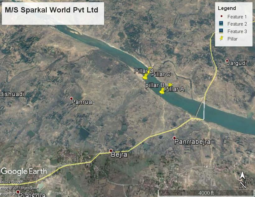
2 1. EXECUTIVE SUMMARY The proposed project of Ha (9.70 acre) areas is of stream bed sand mining and falls under Category- B2 as per EIA Notification 2006 of the Ministry of Environment Forests & Climate Change New Delhi. The mining lease area is located in Village- Baijra & Panduya, Tahsil- Dhanbad, District- Dhanbad, Jharkhand. The proposed project activity will be carried out in the bed of the Barakar River. Mining Lease Area Ha (9.70 acre) Pillar Latitude Longitude A 23 55'35.89"N 86 39'7.54"E Location of mine (Centre) B 23 55'38.2"N 86 39'11.74"E C 23 55'48.25"N 86 39'1.08"E D 23 55'44.57"N 86 38'58.54"E Toposheet No. River/Nalla/Tanks/Lakes etc 73 I/9 Barakar Topography Flat Minerals of mine Sand Proposed production of mine 1,08,000 TPA Method of mining Open Cast Manual Mining Method Dust Suppression 2.5 KLD Water demand Domestic Use 1.5 KLD Green Belt 1 KLD Total 5 KLD Sources of water Nearby village. Ultimate depth of Mining 2 m Man power 28 Solid Waste No waste is expected as all the mineral which is collected is saleable Nearest railway station Kaseetar Railway Station (about 13.5 km in 1
3 Nearest state highway/national highway Nearest Airport NE direction) NH-2: About 15.0 km in S direction NH-32: About 17.5 km in SW direction SH-13: About 14.0 km in W direction Ranchi (Birsa Munda)Airport (about km in SW direction) 2. INTRODUCTION 2.1 Identification of Project and Project Proponent The proposed project at Baijra & Panduya Plot No (P),2366 & 1(P) Sand Mining Project over area of ha on the bank of Barakar River of district Dhanbad Jharkhand. Leas area has been allotted to M/s Sparkal World Pvt. Ltd. after auction by State Govt. has given its consent to grant mining lease vide letter no. 2032/M, Dhanbad Dated 4/11/15 Copy of letter is enclosed as Annexure No.1. The details of the project are given below: Name of the Lessees M/S Sparkal World Pvt. Ltd. Name & Address of Applicant Name of Mine Mineral Area (ha) Postal Address M/S Sparkal World Pvt. Ltd. M/S Sparkle World PvtLtd, Director - Shri Rajan Prasad (Director) Sashtri Nagar, Bank More, Dhanbad Phone No c.debiprasad@gmail.com Baijra & PANDUYA Sand mining Project Located on Barakar River Sand Area: ha M/S Sparkal World Pvt. Ltd. 2
4 M/S Sparkle World PvtLtd, Director - Shri Rajan Prasad (Director) Sashtri Nagar, Bank More, Dhanbad Phone No c.debiprasad@gmail.com Status of Mine Fresh application for Environmental Clearance. 2.2 Brief description of the nature of the project It has been proposed to collect approximately TPA. No mining activity will be undertaken during the monsoon season. So the material will be replenished during the monsoon season every year. Surface Mining: The mining is confined to extraction of sand from the bed of Barakar. The operation will be manual in which the material will be collected in its existing form. Sand will be directly mined from the river bed manually or using excavators/ back-hoes (optional). The labours will load sand onto tipping trucks at the river-bed itself. For the trucks to make access upto the loading point, temporary causeways (proposed at regular interval) on the river-bed will be made along the proposed lease area. The length of the causeway will depend upon the extent of exposed sand banks and sand bars in the area. A sand barrier 1/5th of total width of the river against the river banks will be left unmined for protection of the bank and the habitation in near vicinity to the river. From the river statistics, it has been observed that, on an average, water flows over the sand layers in Barakar River during five months in a year during which (monsoon period) no sand mining operation is practicable. Sand will be mined out during dry season only on exposed sand banks and sand bars during the remaining period of seven months in a year. During this period the area of the sand quarry is free from submersion and the river flows away from the deposit or diverting the flow of water to one side of the bank. However, in case of emergency (i.e. heavy rainfall in the upstream side of the river, release 3
5 of water from upstream dams etc,), the sand mining will have to be stopped till the emergency situation is over. In general, during Monsoon period, the sand mining operation will be kept suspended. The requirement of sand for the monsoon period will be mined beforehand and stacked at the sand stock yards at the end-use plant sites. The mining process is opencast manual method without drilling & blasting. There would be no risk to the employee working in the mines. Except in cases of emergency, when suppliers are to be effected to Government agencies and other requisite parameters of need, semi-mechanized mining operations may be resorted to, without drilling & blasting. As the working is going to be methodical i.e. mining will be done in benches. There would be no risk to the employee working in the mines. a) Mining will be starting from its center and advance toward the banks across the river uniformly. The mineral extraction will be done for a period of 260 days in a year. b) In order to maintain safety and stability of river banks a safety distance of 15 meter on both side of river bank has been left or 1/5 of the width of river bank. c) No mining zone has also been left from the bridge for its safety as shown in the working plan Plate No 2. The lease area gets the sediment deposit due to the river flow which remains undisturbed during the monsoons. The extraction process can slow or stop aggradations thereby maintaining the channel s capacity and its flow. Mode of working: The layout of the proposed sand mine and method of mining with sequence of strip mining operations is shown in development plan. Sand will be won along the deposit of exposed sand banks in a strip fashion. Strips will be marked up to the boundary of proposed sand lease area. The trucks with labours will be placed in midway of the selected strip and sand will be mined height of 3.0m 4
6 each. After taking one initial mining cut from the boundary of allotted mining lease area, the sand winning will be carried out in retreating manner from boundary in regular strips towards the nearest causeway. It will be done in such a manner that the flow of river channel is not obstructed. The guidelines of the Ministry of Environment and Forests as also of the Geological Survey of India will be followed for a proper & scientific mining. I. Dry pit mining will be followed which means mining at all times will be above flowing river bed water level with no mining when water is above bed level. II. Sand will be collected in slices upto a depth of 2.0m or above the ground water level, whichever is less (Maximum depth as per model guidelines of Geological Survey of India and Ministry of Environment & Forest). III. Stream will not be diverted to form inactive channel. IV. Mining at the concave side of the river channel will be avoided to prevent bank erosion. Mining will be restricted minimum 15m away (inward) from river bank to minimize effect of river bank erosion and to avoid consequent channel migration. V. Area of mining lease will be demarcated prior to mining and Pucca Pillars will be erected on ground which will enable systematic mining. VI. No mining operations shall be carried out in proximity of any bridge and/ or embankment. For the optimum utilization of the mineral available in the lease area, mine working has been planned in a scientific and systematic way as shown in the working plan and section. The excavation planning, slope, height, width and length of the bench are planned on the basis of deposit. Since the deposit is very simple, shallow and beds are horizontal, the simple manual mining is most suitable. 5
7 2.3 Need for the project and its importance to the country and region The project lies on the bed of Barakar River. The sediment in the form of river bed material (RBM) deposited in the last many years had changed the shape of the Barakar bed from a valley to a raised land. Hence, it is necessary to remove the materials so that the stream gets channelized. Due to rapid infrastructure development in India, the demand of construction material has increased. To supply this demand, mining of sand is done. This project operation will provide employment directly and indirectly to the people residing in vicinity, thus improving the Socio-economic status of the area. 2.4 Demands-Supply Gap The demand for sand is ever growing with the growth of the infrastructure sector in our country. The mineral is used mainly in the construction activities like buildings, bridges etc. The requirement for the mineral is always high in the cities and towns. Therefore there is always a good demand of the mineral in the domestic market. 2.5 Domestic/ Export Markets The demand in the domestic market is high especially in the nearby towns and cities and hence the need for sand mining. 2.6 Employment Generation This project operation will provide livelihood to the poorest section of the society. It will provide employment to the people residing in vicinity and indirectly by the development of supporting infrastructure. Depending upon the General shifts working, following will be the proposed manpower. S. No. Category Numbers 1. Foreman 1 6
8 2 Supervisor 1 3 Water sprinkler 1 4 Drinking water supplier 1 5 Labour 24 TOTAL 28 3 PROJECT DESCRIPTION 3.1 Type of project including interlinked and interdependent projects, if any The proposed project is for the extraction of sand from the dry bed of river by manual operation. This is an independent project. 3.2 Location The mining lease area is located in Village: Baijra & PANDUYA, Tahsil- Dhanbad, Dist. Dhanbad and Jharkhand. The proposed project activity will be carried out in the bed of the Barakar. The mining lease area falls in Survey of India Toposheet No. 73 I/9. Google earth image showing buffer of 10km radius and Toposheet map of 1:50,000 scale showing buffer of 10km radius is attached with proposal. Detailed Surface Plan and Working Plan of the site are attached as Annexure. The mine site is located at: Pillar Latitude Longitude A 23 55'35.89"N 86 39'7.54"E B 23 55'38.2"N 86 39'11.74"E C D 23 55'48.25"N 86 39'1.08"E 23 55'44.57"N 86 38'58.54"E The vicinity map of the project site is given below: Location Map 7

9 Project Site 8
10 3.3 Details of alternate sites considered No alternative site has been considered, as the mining is site specific. 3.4 Size or magnitude of operation The proposed mine has lease over an area of ha. The total extractable material would be approx TPA. 3.5 Project description with process details Method for developing and working the deposits The sand deposited as stream bed material will be collected in its existing form Method of mining The mining is confined to extraction of sand from the river bed. The operation will be manual as well as mechanized (optional) in which the material will be collected in its existing form. Hand tools like shovel, pan, sieve etc. will be used. Mining will be carried out only during the day time. Extraction of the minor mineral will be completely stopped during the monsoon season. Working Depth (below ground level) During the entire lease period, the deposit will be worked from the top surface to 2 m bgl or above ground water level, whichever comes first. 3.6 Raw Material Required Along With Estimated Quantity, Likely Source, Marketing Area of Final Product/S, Mode of Transport of Raw Material and Finished Product No raw material will be required in the proposed project. The operation involves the extraction of sand in its existing form and loaded into trucks which will transport the material to the local market. The existing roads will be utilized for the transport of sand from mine site to market. 9
11 3.6.1 Use of Mineral Minor mineral namely sand is used as construction material for buildings, bridges etc Mineral Beneficiation No mineral beneficiation is involved Surface Transport The transportation of sand will be carried out by the purchaser through their own transport. There are all weather metalled road and then an unmetalled road right upto the mines to dispatch the material from mines to the market. It will be purchased by the customers at mine site and transported by them through their own arrangement of trucks. The practice is quite sound in the area and ensure continuous lifting of the material. However necessary arrangement of truck can be done from the local truck operator union. 3.7 Resource optimization/ recycling and reuse Not envisaged. 3.8 Availability of water its source, energy/ power requirement and source Water Requirement In the proposed project there is no need of water to carry out operations but for drinking water which will be required for the working people and for the dust suppression. The number of working people will be 30, so the water requirement for drinking and for dust suppression will be around 5 KLD. This water will be supplied from the nearby village by tankers Power Requirement All the activities will be carried out in a manual manner. The operation will be done only from sunrise to sunset hence there is no power requirement for the project at site. 3.9 Quantity of wastes to be generated (liquid and solid) and scheme for their management/ disposal. 10
12 3.9.1Solid Waste Generation & its Disposal There are no mineral rejects of any kind produced during mining, therefore, no provision of stock yard is proposed. The entire mineral produced is saleable Liquid Effluent No liquid effluents will be generated at the mine site. 4. SITE ANALYSIS 4.1 Connectivity The mine site is connected via an un-metalled road of approx. 2 kilometer which further joins the NH-2 towards South at a distance of approx. 15 Km. 4.2 Land form, land use and land ownership The proposed activity is to take place in the bed of the Barakar Riverand hence there will be no change in land use. 4.3 General Geology: Rajmahal Plateau The Rajmahal hills composed primarily of Mesozoic volcanic basaltic traps along with Gondwana sediments in the form of Intra Trappean Beds form a plateau ( m) above msl in Shaebganj and Pakur districts of the eastern part of the state of Jharkhand. The Rajmahal plateau trends N-S with a slope towards east possibly as a result of uplift in the west. The subsidence of the eastern region had led to the deposition of Recent Ganga sediments on this part. Geology and Mineral Resources of Jharkhand Jharkhand state a part of the Indian Peninsular Shield is a stable cratonic block of the earth s crust. Jharkhand is known for its diversified geological set up. The whole of Singhbhum region is considered as a natural geological 11
13 museum. Geologically, Jharkhand consists of different types of rock formations ranging from Pre-Cambrian to Cenozoic era. The most predominant hard rocks in the state comprise of the Archaean metamorphics with associated intrusives and sedimentaries belonging to Vindhyan and Gondwana Super Group with associated igneous rocks. The Raj Mahal hills, lying in the north-eastern extremity of the Chotanagpur Plateau consists of Jurassic volcanic lava flows. The Archaean metamorphics occur in East and West Singhbhum, Ranchi, Gumla, Lohardaga, Palamu, Giridih, Hazaribagh, Chatra, Ramgarh, Dhanbad, Godda, Deoghar and Dumka districts. They are represented by various types of Schists, Gneisses, Granulities, Quartzites, Meta basics and other basic intrusives and Granites. The Archaean formations of West Singhbhum district possesses the iron bearing Iron Ore Group. The Vindhyans comprising chiefly of Khenjua-shales, Procelanite, Limestone and Sandstones occupy a small area in the north-western part of Garhwa district. The Gondwanas are represented by alteration of agrillaceous and arenaceous sediment & intervened with numerous coal seams. They are located in Palamu, Ranchi, Hazaribagh, Bokaro, Chatra, Dumka, Giridih, Dhanbad and Godda districts. Structurally the state can be divided into Southern Singhbhum Province and Northern Chotanagpur Province devided by Tamar Khatra Fault (TKF) popularly known as the Northern Singhbhum Shear Zone. The famous Singhbhum Thrust Zone is the store house of several important minerals traversing East Singhbhum, West Singhbhum and Saraikela-Kharsawan district. 4.4 Physiography The physiography of Jharkhand is largely defined by the Chhotanagpur Plateau (CNP) region and other distinct geomorphic domains. The Chhotanagpur Plateau (CNP) region extending from the western part of state to the border of West Bengal in the east is characterized by distinct steps i.e. level of planation. This has been further divided into a number of 2nd and 3rd order division based on variation in relief, drainage and geology. Based on broad geomorphic parameters, Jharkhand may be divided into the following geomorphic domains. 12
14 Ranchi Plateau Hazaribagh Plateau Koderma Plateau The Pat Region Rajmahal Plateau Source: Mine Plan 4.5 Existing land use pattern The area considered for mining of the material has not been utilized for any purpose other than for the natural flow of the Barakar River. The objective of this operation is only to regulate the flow in its natural course which is presently being hindered by the sedimentation over a long period of time. 4.6 Soil classification The soils of the district are mostly of the residual type. High temperature and high rainfall have led to the formation of lateritic type of soils from rocks of Archean metamorphic complex exposed in the greater part of the district and also from the lower Gondwana rocks in the west-central and east central parts. Texturally the soils of the district have been classified into four classes--- Stony and gravelly soils--- These are low-grade soils having a large admixture of cobbles, pebbles and gravels generally found at the base of the hills. Sandy soils These types of soils are generally found near the river and streambeds. They contain more than 60 percent sand and poor in plant nutrients. They are also called hungry soils because of heavy manuring required. Loamy soils--- They consist mostly detritus of decomposed rocks and vegetable matter and contain between 30 to 60 percent sand. 13
15 Clayey soils These soils are sticky when wet and very hard and difficult to break when dry. They are very fertile but yield in such soils improve with addition of sand, lime, coarse bulky manures etc Source: 4.7Climatic data from secondary sources RAINFALL & CLIMATE Dhanbad areas receive more rainfall due to coal dust, which attracts clouds and brings rainfall to the area. Rainfall is the principal method of ground water recharge to ground water. Southwest monsoon brings rainfall to this area during the months of June to October mainly. Normal data of the Dhanbad I.M.D. observatory indicates 1306 mm of rainfall. Source: 5. PLANNING BRIEF 5.1 Planning concept Mining will be done as approved mine plan. Maximum production per year will be not exceed than TPA. 5.2 Population projection The project will employ most of the workers from nearby villages. There will not be any increase in population due to the project. 5.3Landuse planning The land use of the mine lease area is the Barakar River and there will be no change in landuse after operation. The excavated sand will be replenished every year during the monsoon season. Hence the ultimate land use of the mine lease area will not be change. 14
16 5.4 Amenities/facilities Temporary rest shelters, Portable toilets First aid provision will be made available to the mine workers at the site. 6. PROPOSED INFRASTRUCTURE 6.1 Industrial area (Processing Area) No industrial area is proposed. 6.2 Residential area (Non Processing Area) The mine workers will be hired from nearby villages, so residential areas will not be made. 6.3 Green belt Plantation will be raised along the bank of the river both sides of roads and civic amenities in consultation with the local authorities. 6.4 Connectivity The mine site is connected via an un-metalled road of approx. 2 kilometer which further joins the NH-2 towards South at a distance of approx. 15 Km. 6.5 Drinking Water Management Water for drinking and operations is proposed to obtain water from ground water from nearby villages. And proper permission will be taken from concerned authorities. About 1.5 KLD is required for drinking purpose. 6.6 Sewerage System No Sewerage System is provided at the mine site. 6.7 Industrial Waste Management Not applicable 6.8 Solid Waste management No solid waste generation is expected from the mining operation. 15
17 6.9 Power Requirement & Supply/ Source All the activities will be carried out in a manually. The operation will be done only from sunrise to sun set hence there is no power requirement for the project at site. Budget for Corporate Social Responsibility (CSR) SI. No. Activity Capital Cost (in Rs.) 1 Provide drinking water facility in surrounding villages and schools by constructing water tanks at schools 1,00,000 2 Solar lamp distribution 1,00, Construction of Ladies Toilet 1,00, 000 TOTAL 3,00, Environmental Management Plan The environmental management plan consists of the set of mitigation, management, monitoring and institutional measures to be taken during the implementation and operation of the project, to eliminate adverse environmental impacts or reduce them to acceptable levels. The present environmental management plan addresses the components of environment, which are likely to be affected by the different operations in the mine area. Budget Allotted for the Environmental Management Plan:- 16
18 SI. No. Measures Capital Cost (In Rs.) 1 Pollution Control Dust Suppression 1,00,000 Recurring Cost (in Rs.) 25,000 2 Pollution Monitoring i) Air pollution ii) Water pollution iii) Soil Pollution iv) Noise Pollution ,000 25,000 25,000 25,000 3 Plantation Cost 1,00,000 1,00,000 Total 2,00, 000 2,25, Social Infrastructure The Applicant shall spend some amount of project cost for the development of the area as per the local needs i.e. treatment of poor, schools, temples and other social work. 7. REHABILITATION AND RESETTLEMENT (R&R) PLAN Not Applicable 8. PROJECT SCHEDULE & COST ESTIMATES. The project will commence once Environmental Clearance and other necessary certificates are obtained from the respective departments. The total cost of project including Auction Cost would be around Rs. 40 Lakh 9. ANALYSIS OF PROPOSAL 17
19 The project involves collection of river bed material. This is very essential in order to prevent widening of the riverbeds and to prevent flooding off and damage to the adjoining areas. This can only be achieved by maintaining the existing course of the river. The river banks, on both sides are covered by vegetation and human habitats. Widening of river banks results in excessive erosion; resulting in damage to flora, agricultural land and settlements which are situated at very close proximity. This project operation will provide livelihood to the poorest section of the society. It provides employment to the people residing in vicinity directly or indirectly by the project. The sand extracted is in high demand in the local market. This also ensures scientific method of sand extraction. ************ 18
Kurnool vide Proceedings No. 712/Q1/2012 dated Ulindakonda Village, Kallur Mandal, Kurnool District,
 1.0 EXECUTIVE SUMMARY 1.1 Introduction The proposed mining area of 1.157Ha. in survey No. 291 of Ulindakonda Village, Kallur Mandal, Kurnool District has been leased to M/s.Sri Lakshmi Sreenivasa Stone
PRE FEASIBILITY REPORT. Quartz and Feldspar Sy No 119 & 126/3, Kambampadu Village A. Konduru Mandal, Krishna District, Andhra Pradesh
 PRE FEASIBILITY REPORT Of Quartz and Feldspar Sy No 119 & 126/3, Kambampadu Village A. Konduru Mandal, Krishna District, Andhra Pradesh Area of Mining Lease 2.720 Ha For 1, 09,055.08 MT/Annum OF Quartz
APPLICANT: MD. SARFARAZ ANSARI & VIVEKA NAND RAY PRE FEASIBILITY REPORT PRE- FEASIBILITY REPORT
 PRE- FEASIBILITY REPORT 0 CONTENTS EXECUTIVE SUMMARY... 3 1.0 INTRODUCTION... 3 1.1 SALIENT FEATURES OF THE PROJECT... 4 1.2 PRESENT LAND USE PLAN... 5 1.3 PROPOSED PLANNING... 5 1.4 UTILIZATION... 5 2.
FOR Sand Stone Quarry Village : Chhirraleva Tehsil : Basna District : Mahasamund
 Project Report FOR Sand Stone Quarry at Village : Chhirraleva Tehsil : Basna District : Mahasamund Contents 1. About the Firm... 1 2. Location of the Project... 1 3. Environmental Setting of Project...
PRE - FEASIBILITY REPORT Shri Santosh Kumar Dwivedi S/o Shri Goverdhan Dwivedi R/o Village Adampur Saibasi Majre
 1. EXECUTIVE SUMMARY PRE - FEASIBILITY REPORT Shri Santosh Kumar Dwivedi S/o Shri Goverdhan Dwivedi R/o Village Adampur Saibasi Majre Sarkandi, Tehsil and District - Fatehpur, Uttar Pradesh is the lessee
TABLE OF CONTENTS. 1.0 Introduction. 2.0 Geology, Exploration and Reserves. 3.0 Mining. 4.0 Blasting. 5.0 Mine Drainage. 6.
 TABLE OF CONTENTS 1.0 Introduction 2.0 Geology, Exploration and Reserves 3.0 Mining 4.0 Blasting 5.0 Mine Drainage 6.0 Site Services 1.0 INTRODUCTION Pankaj Chandrakar a resident oftemri, P.O. Deopuri
Report for Area Drainage Studies for 1320 MW (2x660 MW) THERMAL POWER PROJECT AT MIRZAPUR, U.P.
 THERMAL POWER PROJECT AT MIRZAPUR, U.P.") Report for Area Drainage Studies for 1320 MW (2x660 MW) THERMAL POWER PROJECT AT MIRZAPUR, U.P. 1. Introduction M/s Welspun Energy Uttar Pradesh Ltd. (WEUPL) is putting up 1320 MW (2 x 660 MW) coal fired
Report for Area Drainage Studies for 1320 MW (2x660 MW) THERMAL POWER PROJECT AT MIRZAPUR, U.P. 1. Introduction M/s Welspun Energy Uttar Pradesh Ltd. (WEUPL) is putting up 1320 MW (2 x 660 MW) coal fired
Of Sri. Mohammad Akram. At Karigala Village, H.D. KoteTaluk, Mysore District, Karnataka Latitude & Longitude Piller Latitude Longitude Coordinates
 1.0 EXECUTIVE SUMMARY 1.1 Introduction The proposed mining lease area applied for quarrying of Steatite Stone (soap stone) by Sri. Mohammad Akramis situated in survey no. No. 402of 1-30 Acres of Karigala
PRE-FEASIBILITY REPORT VASAI LIMESTONE MINE (APPLICANT: SHRI KHERAJBHA KARUBHA KER)
") PRE-FEASIBILITY REPORT OF VASAI LIMESTONE MINE (APPLICANT: SHRI KHERAJBHA KARUBHA KER) 1. EXECUTIVE SUMMARY: The existing Mining lease for mineral Limestone over 4.9000 Hectares for a period of thirty
PRE-FEASIBILITY REPORT OF VASAI LIMESTONE MINE (APPLICANT: SHRI KHERAJBHA KARUBHA KER) 1. EXECUTIVE SUMMARY: The existing Mining lease for mineral Limestone over 4.9000 Hectares for a period of thirty
ANNEXURE I Site Location map of M/s. Stone Plus quarry lease A-1
 ANNEXURE I Site Location map of M/s. quarry lease A-1 Quarry Lease boundary map of M/s. A-2 a. Introduction M/s. proposes to conduct semi mechanized open cast method quarrying for Colour granite extraction
Submitted to: Central Coalfields Limited Ranchi, Jharkhand. Ashoka & Piparwar OCPs, CCL
 Land Restoration / Reclamation Monitoring of more than 5 million cu. m. (Coal + OB) Capacity Open Cast Coal Mines of Central Coalfields Limited Based on Satellite Data for the Year 2013 Ashoka & Piparwar
APPLICANT: M/s. Rock Sand & Minerals Pvt Ltd PRE-FEASIBILITY REPORT
 PRE- FEASIBILITY REPORT 1.1 Introduction EXECUTIVE SUMMARY The proposed mining lease of 19.80ha in survey no. 345 was granted to M/s. Rock Sand Minerals Pvt Ltd, for a period of 15 years by Asst. Director
THE MINISTRY OF ENERGY AND ENERGY INDUSTRIES MINERALS DIVISION MINE DESIGN TEMPLATE OPERATOR NAME: OPERATOR ADDRESS: PHONE NUMBER: FACSIMILE:
 THE MINISTRY OF ENERGY AND ENERGY INDUSTRIES MINERALS DIVISION MINE DESIGN TEMPLATE 1.0 GENERAL INFORMATION OPERATOR NAME: OPERATOR ADDRESS: PHONE NUMBER: FACSIMILE: NAME OF CONTACT: CELLULAR PHONE: EMAIL
2 Aggregates in Indiana
 2 Aggregates in Indiana Origin of Aggregates Gravel and Natural Sands Crushed Stone Slag Distribution of Aggregates Glacial Deposits Bedrock Deposits Aggregate Types Natural Aggregates Artificial Aggregates
FIELD MONITORING OF STABILITY OF DUMP A CASE STUDY
 FIELD MONITORING OF STABILITY OF DUMP A CASE STUDY Dr. Singam Jayanthu*, and Dr. Simantini Behera** Professor, Associate Professor Department of Mining Engineering National Institute of Technology Rourkela-769008
HISTORY OF CONSTRUCTION FOR EXISTING CCR SURFACE IMPOUNDMENT PLANT GASTON ASH POND 40 CFR (c)(1)(i) (xii)
(1)(i) (xii)") HISTORY OF CONSTRUCTION FOR EXISTING CCR SURFACE IMPOUNDMENT PLANT GASTON ASH POND 40 CFR 257.73(c)(1)(i) (xii) (i) Site Name and Ownership Information: Site Name: E.C. Gaston Steam Plant Site Location:
HISTORY OF CONSTRUCTION FOR EXISTING CCR SURFACE IMPOUNDMENT PLANT GASTON ASH POND 40 CFR 257.73(c)(1)(i) (xii) (i) Site Name and Ownership Information: Site Name: E.C. Gaston Steam Plant Site Location:
MCDR INSPECTION General. Date of Inspection Name of the Mine Bhatbhera Limestone Mine 2 Total Lease Area (Ha)
") ::1:: MCDR INSPECTION General SN Particulars Details Date of Inspection 23.8.2015 1 Name of the Mine Bhatbhera Limestone Mine 2 Total Lease Area (Ha) 4.808 Hect (Govt. Revenue Land), Non-forest land with
::1:: MCDR INSPECTION General SN Particulars Details Date of Inspection 23.8.2015 1 Name of the Mine Bhatbhera Limestone Mine 2 Total Lease Area (Ha) 4.808 Hect (Govt. Revenue Land), Non-forest land with
MCDR INSPECTION REPORT. S. N. Particulars Details 1 Name of the Mine, Inspecting officer with Designation, Date of Inspection
 MCDR INSPECTION REPORT General S. N. Particulars Details 1 Name of the Mine, Inspecting officer with Designation, Date of Inspection Bharuadih Limestone Mine,Rajesh Kumar Das,Sr.ACOM,18.08.2017 2 Total
Soil Mechanics/Geotechnical Engineering I Prof. Dilip Kumar Baidya Department of Civil Engineering Indian Institute of Technology, Kharagpur
 Soil Mechanics/Geotechnical Engineering I Prof. Dilip Kumar Baidya Department of Civil Engineering Indian Institute of Technology, Kharagpur Lecture - 01 Rock Cycle Good morning. I welcome you to this
INTRODUCTION. Climate
 INTRODUCTION Climate Landslides are serious natural disasters in many parts of the world. Since the past 30 years, rainfall triggered landslides and debris flows had been one of the natural disasters of
PRE FEASIBILITY REPORT OF QUARTZ & FELDSPAR MINING PROJECT (ML No- 80/03) FOR TERMS OF REFERENCE
 FOR TERMS OF REFERENCE") PRE FEASIBILITY REPORT OF QUARTZ & FELDSPAR MINING PROJECT (ML No- 80/03) FOR TERMS OF REFERENCE Village Ashapura Tehsil Nasirabad District Ajmer State Rajasthan Capacity 35945 TPA ROM (Max) Lease Area
PRE FEASIBILITY REPORT OF QUARTZ & FELDSPAR MINING PROJECT (ML No- 80/03) FOR TERMS OF REFERENCE Village Ashapura Tehsil Nasirabad District Ajmer State Rajasthan Capacity 35945 TPA ROM (Max) Lease Area
Result of Field Geological Survey and Ground Truth for the Analysis Date: 2007/7/5 Location (UTM) Elev Geological Unit Point No. NT-02 VSW Index 260,7
 Elev Geological Unit Point No. NT-02 VSW Index 260,7") Date: Point No. 2007/7/5 NT-01 Result of Field Geological Survey and Ground Truth for the Analysis Location (UTM) Topography of granite hill in flat land Lithology: Medium grained hornblende granite. Topography:
Date: Point No. 2007/7/5 NT-01 Result of Field Geological Survey and Ground Truth for the Analysis Location (UTM) Topography of granite hill in flat land Lithology: Medium grained hornblende granite. Topography:
FOREST RESEARCH INSTITUTE, DEHRADUN
 PROJECT REPORT DRAINAGE AND REPLENISHMENT STUDY OF MINED AREA OF GANGA SHYAMPUR RIVER HARIDWAR Submitted to UTTARAKHAND FOREST DEVELOPMENT CORPORATION (UFDC) 73, Nehru Road, Deharadun Prepared&Submitted
24.0 Mineral Extraction
 Chapter 24 - Mineral Extraction 24.0 Mineral Extraction 24.1 Introduction Apart from gravel, sand, rock, limestone and salt extraction in relatively small quantities mineral extraction is not a strong
MCDR INSPECTION REPORT
 MCDR INSPECTION REPORT General S. N. Particulars Details 1 Name of the Mine Matia Limestone Mine 2 Total Lease Area (Ha) with breakup of Non-forest and forest 12.137 Ha. land 3 Mine code 38CHG14086 4 IBM
ANNEXURE-I (AS PER FORMAT ISSUED BY BIHAR-SEIAA)
") ANNEXURE-I (AS PER FORMAT ISSUED BY BIHAR-SEIAA) ANNEXURE-II (AS PER FORMAT ISSUED BY BIHAR-SEIAA) ANNEXURE-III LETTER OF INTENT Scanned by CamScanner Scanned by CamScanner Scanned by CamScanner
ANNEXURE-I (AS PER FORMAT ISSUED BY BIHAR-SEIAA) ANNEXURE-II (AS PER FORMAT ISSUED BY BIHAR-SEIAA) ANNEXURE-III LETTER OF INTENT Scanned by CamScanner Scanned by CamScanner Scanned by CamScanner
Name. 4. The diagram below shows a soil profile formed in an area of granite bedrock. Four different soil horizons, A, B, C, and D, are shown.
 Name 1. In the cross section of the hill shown below, which rock units are probably most resistant to weathering? 4. The diagram below shows a soil profile formed in an area of granite bedrock. Four different
Continental Landscapes
 Continental Landscapes Landscape influenced by tectonics, climate & differential weathering Most landforms developed within the last 2 million years System moves toward an equilibrium Continental Landscapes
JAI MAA SHARDA STONE CRUSHING
 JAI MAA SHARDA STONE CRUSHING Prop. Hukum Singh (M. No. 9425585252) Near-Pahunadukan Kedarpur Ambikapur, (C.G.) To, The Member Secretary, SLEIAA(State Level Environment Impact Assessment Authority), Ministry
FORM -1 MINING PLAN & PRE-FEASIBILITY REPORT
 FORM -1 MINING PLAN & PRE-FEASIBILITY REPORT TO OBTAIN ENVIRONMENTAL CLEARANCE FOR QUARRYING OF ROUGH STONE (Extent 1.91.5Ha)-B2 Project IN S.F.No 1257/1 Village Nagamangalam Taluk Denkanikottai District
LAB 2 IDENTIFYING MATERIALS FOR MAKING SOILS: ROCK AND PARENT MATERIALS
 LAB 2 IDENTIFYING MATERIALS FOR MAKING SOILS: ROCK AND PARENT MATERIALS Learning outcomes The student is able to: 1. understand and identify rocks 2. understand and identify parent materials 3. recognize
MCDR INSPECTION REPORT
 MCDR INSPECTION REPORT 1.0 GENERAL SN Particulars Details 1 Name of the inspecting officer J.S. Hada, AMG 2 Date of Inspection 9.9.2017 3 Accompanying mine official Lessee and Mining Engineer Shri K.L.
As compaction and cementation of these sediments eventually occur, which area will become siltstone? A) A B) B C) C D) D
 A B) B C) C D) D") 1. A student obtains a cup of quartz sand from a beach. A saltwater solution is poured into the sand and allowed to evaporate. The mineral residue from the saltwater solution cements the sand grains together,
1. A student obtains a cup of quartz sand from a beach. A saltwater solution is poured into the sand and allowed to evaporate. The mineral residue from the saltwater solution cements the sand grains together,
Description DESCRIPTION
 DESCRIPTION The location of the Upper James Watershed is located in northeastern South Dakota as well as southeastern North Dakota. It includes the following counties located in North Dakota Barnes, Dickey,
Geological report on Limestone Exploration of Goyla Block, Abadasa Taluka, Kachchh District, Gujarat. Executive Summary
 Geological report on Limestone Exploration of Goyla Block, Abadasa Taluka, Kachchh District, Gujarat Executive Summary Prepared for Commissioner of Geology & Mining Government of Gujarat Prepared by Geovale
Geological Report on Limestone Exploration of Mudhvay Sub-block A, Lakhpat Taluka, Kachchh District, Gujarat. Executive Summary
 Geological Report on Limestone Exploration of Mudhvay Sub-block A, Lakhpat Taluka, Kachchh District, Gujarat Executive Summary Prepared for Commissioner of Geology & Mining Government of Gujarat Prepared
2 INTRODUCTION OF THE PROJECT/BACKGROUND INFORMATION:
 1. EXECUTIVE SUMMARY The proposed mining project is located near Mauza & Mohal Lodhwan/Pail, Tehsil Nurpur, District Kangra, Himachal Pradesh. The proposed project is of sand, stone and bajri mining having
2. PHYSICAL FEATURES OF INDIA
 2. PHYSICAL FEATURES OF INDIA Question 1: Choose the right answer from the four alternatives given below. (i) A landmass bound by sea on three sides is referred to as (a) Coast (c) Peninsula (b) Island
Submitted to Central Coalfields Limited BHURKUNDA OCP, CCL
 Land Restoration / Reclamation Monitoring of Open Cast Coal Mines of Central Coalfields Limited producing less than 5 m cu m. (Coal+ OB) based on Satellite Data for the Year 2013 BHURKUNDA OCP, CCL Submitted
NOA ASSESSMENT HARRIS QUARRY MENDOCINO COUNTY, CALIFORNIA TABLE OF CONTENTS
 NOA ASSESSMENT HARRIS QUARRY MENDOCINO COUNTY, CALIFORNIA TABLE OF CONTENTS Introduction... 1 Scope of Services... 1 Project Location and Description... 1 Geologic Setting... 1 Regional Geology... 1 Site
MCDR INSPECTION REPORT
 MCDR INSPECTION REPORT General S. N. Particulars Details 1 Name of the Mine Matia Limestone Mine 2 Total Lease Area (Ha) with breakup of Non-forest and forest 8.144 ha.,non forest land land 3 Mine code
1.0 PURPOSE AND FORMAT OF THE FINAL EIR
 1.0 PURPOSE AND FORMAT OF THE FINAL EIR 1.1 PROJECT OVERVIEW CEMEX (RMC Pacific Materials, dba CEMEX) operates the Bonny Doon Shale and Limestone Quarries in Santa Cruz County for the production of Portland
Local Area Key Issues Paper No. 13: Southern Hinterland townships growth opportunities
 Draft Sunshine Coast Planning Scheme Review of Submissions Local Area Key Issues Paper No. 13: Southern Hinterland townships growth opportunities Key Issue: Growth opportunities for Southern Hinterland
Geological Report on Limestone Exploration of Mudhvay Sub-block B, Lakhpat Taluka, Kachchh District, Gujarat. Executive Summary
 Geological Report on Limestone Exploration of Mudhvay Sub-block B, Lakhpat Taluka, Kachchh District, Gujarat Executive Summary Prepared for Commissioner of Geology & Mining Government of Gujarat Prepared
Big Rivers Electric Corporation Disposal of Coal Combustion Residuals (CCR) from Electric Utilities Final Rule CCR Impoundment Liner Assessment Report
 from Electric Utilities Final Rule CCR Impoundment Liner Assessment Report") Big Rivers Electric Corporation Disposal of Coal Combustion Residuals (CCR) from Electric Utilities Final Rule CCR Impoundment Liner Assessment Report CCR Surface Impoundment Information Name: Operator:
Big Rivers Electric Corporation Disposal of Coal Combustion Residuals (CCR) from Electric Utilities Final Rule CCR Impoundment Liner Assessment Report CCR Surface Impoundment Information Name: Operator:
(3) The consent letter/declaration/undertaking may have uniform signature of the lessee.
 The consent letter/declaration/undertaking may have uniform signature of the lessee.") Annexure SCRUTINY COMMENTS ON THE DRAFT REVIEW OF MINING PLAN AND PMCP OF RAJABERA IRON ORE MINE (41.697 HA.) OF SHRI PADAM KUMAR JAIN LOCATED IN SINGHBHUM (WEST) DISTRICT, JHARKHAND SUBMITTED UNDER RULE
Annexure SCRUTINY COMMENTS ON THE DRAFT REVIEW OF MINING PLAN AND PMCP OF RAJABERA IRON ORE MINE (41.697 HA.) OF SHRI PADAM KUMAR JAIN LOCATED IN SINGHBHUM (WEST) DISTRICT, JHARKHAND SUBMITTED UNDER RULE
Central Queensland Coal Project Appendix 4b Geotechnical Assessment. Environmental Impact Statement
 Central Queensland Coal Project Appendix 4b Geotechnical Assessment Environmental Impact Statement GEOTECHNICAL ASSESSMENT OF OPEN CUT MINING ADJACENT TO THE BRUCE HIGHWAY, CENTRAL QUEENSLAND COAL PROJECT
Chapter 8 Earth Systems and Resources
 Chapter 8 Earth Systems and Resources Earth s resources were determined when the planet formed. The Earth s Crust Layers Core: innermost zone of the planet, largely nickel and iron. Mantle: above the core,
Granite Building Stone Quarry of Sri. Sajan Mani.
 1. EXECUTIVE SUMMARY: Sri. Sajan Mani had made an application for Granite building stone quarrying located in Sy. No. 2398, Peechi Village, Thrissur Taluk, Thrissur District, Kerala State. Over an extent
The Soils and Land Capability for Agriculture. Land North of Aberdeen, Aberdeenshire
 The Soils and Land Capability for Agriculture Of Land North of Aberdeen, Aberdeenshire Report prepared for Peter Radmall Associates May 2012 Reading Agricultural Consultants Ltd Beechwood Court, Long Toll,
THIS IS A NEW SPECIFICATION
 THIS IS A NEW SPECIFICATION ADVANCED GCE GEOLOGY Environmental Geology F794 * OCE / 12353* Candidates answer on the Question Paper OCR Supplied Materials: None Other Materials Required: Ruler (cm/mm) Thursday
3/3/2013. The hydro cycle water returns from the sea. All "toilet to tap." Introduction to Environmental Geology, 5e
 Introduction to Environmental Geology, 5e Running Water: summary in haiku form Edward A. Keller Chapter 9 Rivers and Flooding Lecture Presentation prepared by X. Mara Chen, Salisbury University The hydro
Soil. Soil in Our Environment
 Soil Soil in Our Environment What is soil? Or is it Dirt? Gold s father is dirt, yet it regards itself as noble. Yiddish Proverb Is it alive? Is it fragile? Formations of Soils How much time does it take
Figure 2.1: Constituent Area
 2 The Region 2.1 CONSTITUENT AREA The National Capital Region includes NCT-Delhi, nine districts of Haryana, six districts of Uttar Pradesh and one district of Rajasthan. Total area of the region is 34,144
The elevations on the interior plateau generally vary between 300 and 650 meters with
 11 2. HYDROLOGICAL SETTING 2.1 Physical Features and Relief Labrador is bounded in the east by the Labrador Sea (Atlantic Ocean), in the west by the watershed divide, and in the south, for the most part,
PHYSICAL GEOGRAPHY: An overview. Definitions. Faulting. Folding GEOLOGIC PROCESSES 9/17/2013 TOPOGRAPHIC RELIEF
 TOPOGRAPHIC RELIEF PHYSICAL GEOGRAPHY: An overview Prof. Anthony Grande AFG 0913 2 Definitions GEOLOGIC PROCESSES Geography: Study of people living on the surface of the earth. Geology: the study of the
FOR QUARRYING OF KAGANAM ROUGH STONE AND GRAVEL QUARRY
 PROPOSAL TO OBTAIN ENVIRONMENTAL CLEARANCE FROM District Level Environment Impact Assessment Authority (DEIAA), Tiruvannamalai District, Tamilnadu FOR QUARRYING OF KAGANAM ROUGH STONE AND GRAVEL QUARRY
[Penumaka, 7(1): January-March 2017] ISSN Impact Factor
![[Penumaka, 7(1): January-March 2017] ISSN Impact Factor](/thumbs/95/124653515.jpg "[Penumaka, 7(1): January-March 2017] ISSN Impact Factor") INTERNATIONAL JOURNAL OF ENGINEERING SCIENCES &MANAGEMENT HYDROGEOMORPHOLOGY OF CHEVELLA BASIN, RANGA REDDY DISTRICT, TELANGANA STATE Penumaka Ramesh* 1 & Podila Sankara Pitchaiah 2 * 1&2 Department of
INTERNATIONAL JOURNAL OF ENGINEERING SCIENCES &MANAGEMENT HYDROGEOMORPHOLOGY OF CHEVELLA BASIN, RANGA REDDY DISTRICT, TELANGANA STATE Penumaka Ramesh* 1 & Podila Sankara Pitchaiah 2 * 1&2 Department of
Geology and Nonrenewable Mineral Resources
 Environmental Science, 15e MILLER/SPOOLMAN G. TYLER MILLER SCOTT E. SPOOLMAN 12 Geology and Nonrenewable Mineral Resources Core Case Study: The Crucial Importance of Rare Earth Metals There are 17 rare
INDIAN BUREAU OF MINES MINERALS DEVELOPMEMT AND REGULATION DIVISION MCDR INSPECTION REPORT. Chennai regional office
 1. Mine file No : (i) Name of the Inspecting : Officer and ID No. INDIAN BUREAU OF MINES MINERALS DEVELOPMEMT AND REGULATION DIVISION TN/TCR/LST-1, MDS (ii) Designation : (iii) Accompaning mine : Official
This is intended for use to achieve the following regulatory and management objectives:
 INTRODUCTION Environmental destruction is the price mankind has to pay for unsustainable development. Alarming increase in indiscriminate sand mining has caused serious damage to the river system. As the
EMP. In respect of. Cluster of Two Mines (Cluster area Ha)
") M/s. NSC Consortium, Road Metal Mine 12.146 Ha. EMP In respect of Cluster of Two Mines (Cluster area 22.146 Ha) AT Sy. No. 734/P, Yadavalli Village, Dornala Mandal, Prakasam district, Andhra Pradesh Cluster
M/s. NSC Consortium, Road Metal Mine 12.146 Ha. EMP In respect of Cluster of Two Mines (Cluster area 22.146 Ha) AT Sy. No. 734/P, Yadavalli Village, Dornala Mandal, Prakasam district, Andhra Pradesh Cluster
Section I: Multiple Choice Select the best answer to each question. Mark your final answer on the answer sheet. (1 pt each)
") Sedimentary Rocks & Surface Processes Quest Name: Earth Science 2013 Block: Date: Section I: Multiple Choice Select the best answer to each question. Mark your final answer on the answer sheet. (1 pt each)
Sedimentary Rocks & Surface Processes Quest Name: Earth Science 2013 Block: Date: Section I: Multiple Choice Select the best answer to each question. Mark your final answer on the answer sheet. (1 pt each)
Land subsidence due to groundwater withdrawal in Hanoi, Vietnam
 Land Subsidence (Proceedings of the Fifth International Symposium on Land Subsidence, The Hague, October 1995). 1AHS Publ. no. 234, 1995. 55 Land subsidence due to groundwater withdrawal in Hanoi, Vietnam
mountain rivers fixed channel boundaries (bedrock banks and bed) high transport capacity low storage input output
 high transport capacity low storage input output") mountain rivers fixed channel boundaries (bedrock banks and bed) high transport capacity low storage input output strong interaction between streams & hillslopes Sediment Budgets for Mountain Rivers Little
mountain rivers fixed channel boundaries (bedrock banks and bed) high transport capacity low storage input output strong interaction between streams & hillslopes Sediment Budgets for Mountain Rivers Little
ARCH 1250 APPLIED ENVIRONMENTAL STUDIES
 John Seitz, RA, LEED AP Assistant Adjunct Professor Professor Paul C. King, RA, AIA, ARA Assistant Professor Geology Geology is the scientific study of the structure and composition of the earth s surface
HISTORY OF CONSTRUCTION FOR EXISTING CCR SURFACE IMPOUNDMENT PLANT GADSDEN ASH POND 40 CFR (c)(1)(i)-(xii)
(1)(i)-(xii)") HISTORY OF CONSTRUCTION FOR EXISTING CCR SURFACE IMPOUNDMENT PLANT GADSDEN ASH POND 40 CFR 257.73(c)(1)(i)-(xii) (i) Site Name and Ownership Information: Site Name: Site Location: Site Address: Gadsden
HISTORY OF CONSTRUCTION FOR EXISTING CCR SURFACE IMPOUNDMENT PLANT GADSDEN ASH POND 40 CFR 257.73(c)(1)(i)-(xii) (i) Site Name and Ownership Information: Site Name: Site Location: Site Address: Gadsden
Geological Report on Limestone Exploration Of Bhatvadiya B Block Of EXECUTIVE SUMMARY
 Geological Report on Limestone Exploration Of Bhatvadiya B Block Of Kalyanpur Taluka, Devbhumi Dwarka District, Gujarat EXECUTIVE SUMMARY Prepared for: Gujarat Mineral Research & Development Society Government
Module - 3 GIS MAPPING, MIS AND GIS UNDER RAY
 Module - 3 1 GIS MAPPING, MIS AND GIS MIS INTEGRATION UNDER RAY Role of GIS & MIS under RAY Under the scheme, two step implementation strategy has been adopted i.e. preparation of SFCPoAs on whole city
GOAL 7 AREAS SUBJECT TO NATURAL DISASTERS AND HAZARDS. To protect life and property from natural disasters and hazards.
 GOAL 7 AREAS SUBJECT TO NATURAL DISASTERS AND HAZARDS A. GOALS: To protect life and property from natural disasters and hazards. B. POLICIES: 1. Floodplains shall be maintained as natural drainage-ways.
3.18 GEOLOGY AND SOILS
 3.18 GEOLOGY AND SOILS This section discusses geologic resource concerns as they relate to the environment, public safety, and project design both during construction and after completion of the project.
Rocks, Minerals, & Mining. (I ain t sayin she a golddigga)
") Rocks, Minerals, & Mining (I ain t sayin she a golddigga) The Rock Cycle! Rocks are made up of multiple minerals. Minerals are made up of multiple elements. Rocks and minerals recycle or change due to
Rocks, Minerals, & Mining (I ain t sayin she a golddigga) The Rock Cycle! Rocks are made up of multiple minerals. Minerals are made up of multiple elements. Rocks and minerals recycle or change due to
Granite Building Stone Quarry of M/s Ulikkal Stone Crusher
 1. EXECUTIVE SUMMARY: M/s. Ulikkal Stone Crusher had made an application for Granite building stones quarrying located in Sy. No. 28/1A2 in Vayathur Village, Iritty taluk, Kannur District, Kerals State.
FORM -1 MINING PLAN & PRE-FEASIBILITY REPORT FOR QUARRYING OF BLACK GRANITE
 FORM -1 MINING PLAN & PRE-FEASIBILITY REPORT TO OBTAIN ENVIRONMENTAL CLEARANCE FOR QUARRYING OF BLACK GRANITE (Extent 2.3.0Ha)-B2 Project IN S.F.Nos 248/2 (P), 248/1A (P), 248/1B(P) and 248/1C (P) Village
WATERCOURSE HARNESSING BANK EROSION AND CONSOLIDATION
 GUVERNUL MINISTERUL POSDRU MUNCII, FAMILIEI ŞI WATERCOURSE HARNESSING BANK EROSION AND CONSOLIDATION PhD. student: ALUPOAE Daniel Gheorghe Asachi Technical University of Iasi, Faculty of Civil Engineering
TABLE OF CONTENTS LIST OF TABLES. Page
 TABLE OF CONTENTS Page 11.0 EFFECTS OF THE ENVIRONMENT ON THE PROJECT... 11-1 11.1 Weather Conditions... 11-1 11.2 Flooding... 11-2 11.3 Forest Fires... 11-2 11.4 Permafrost and Subsidence Risk... 11-3
GEOL Introductory Geology: Exploring Planet Earth Fall 2010 Test #2 October 18, 2010
 GEOL 101 - Introductory Geology: Exploring Planet Earth Fall 2010 Test #2 October 18, 2010 Name KEY ID# KEY Multiple choice questions (2 points each). 1. What type of metamorphic rock is formed over large
NATIONAL SENIOR CERTIFICATE GRADE 12
 NATIONAL SENIOR CERTIFICATE GRADE 12 GEOGRAPHY P1 NOVEMBER 2016 ANNEXURE This annexure consists of 11 pages. Geography/P1 2 DBE/November 2016 FIGURE 1.1: MATURE STAGE OF DEVELOPMENT OF A TROPICAL CYCLONE
INSIDE OUR EARTH. The Earth is primarily composed of rocks. They can be in solid, semiplastic GEOGRAPHY. Chapter
 Chapter 2 INSIDE OUR EARTH Unit-1 : OUR ENVIRONMENT GEOGRAPHY 12 Continental Crust and Oceanic Crust The Earth is primarily composed of rocks. They can be in solid, semiplastic (semi molten) or liquid
Flash flood disaster in Bayangol district, Ulaanbaatar
 Flash flood disaster in Bayangol district, Ulaanbaatar Advanced Training Workshop on Reservoir Sedimentation Management 10-16 October 2007. IRTCES, Beijing China Janchivdorj.L, Institute of Geoecology,MAS
Monday 2 June 2014 Morning
 Monday 2 June 2014 Morning A2 GCE GEOLOGY F794/01 Environmental Geology *3076922876* Candidates answer on the Question Paper. OCR supplied materials: None Other materials required: Electronic calculator
Table 1.1 Salient Features of the Mine Site & Surrounding Details
 1.0 EXECUTIVE SUMMARY This is a new mining lease allotted by Auction. LOI of Sand Stone Plot. No.- 31, located near Village- Deriya & Pabunagar, Tehsil-Balesar District Jodhpur (Rajasthan) over an area
Practice Test Rocks and Minerals. Name. Page 1
 Name Practice Test Rocks and Minerals 1. Which rock would be the best source of the mineral garnet? A) basalt B) limestone C) schist D) slate 2. Which mineral is mined for its iron content? A) hematite
LECTURE NOTE ENGINEERING SURVEYING
 LECTURE NOTE ENGINEERING SURVEYING LECTURE 1 Introduction: Surveying is defined as taking a general view of, by observation and measurement determining the boundaries, size, position, quantity, condition,
Reconnaissance. Of the. Denis mineral claims. Situated at Kilometer 844 of the Alaska Highway. Liard Mining Division. Northeastern British Columbia
 Reconnaissance Of the Denis mineral claims Situated at Kilometer 844 of the Alaska Highway Liard Mining Division Northeastern British Columbia N.T.S. 94M.075 Latitude 59 42 25 Longitude 127 13 12 Field
QUARRYING PLAN FOR. PARATAPUR SAND MINING BLOCK - 2 EXTENT Acres (4.93 Hectare)
") QUARRYING PLAN FOR PARATAPUR SAND MINING BLOCK - 2 EXTENT 12.20 Acres (4.93 Hectare) IN KRISHNA RIVER BED ADJACENT TO SY.NO 8/1, 8/2, 7/1 & 7/2 OF PARATAPUR - VILLAGE DEVADURGA - TALUK RAICHUR- DISTRICT
QUARRYING PLAN FOR PARATAPUR SAND MINING BLOCK - 2 EXTENT 12.20 Acres (4.93 Hectare) IN KRISHNA RIVER BED ADJACENT TO SY.NO 8/1, 8/2, 7/1 & 7/2 OF PARATAPUR - VILLAGE DEVADURGA - TALUK RAICHUR- DISTRICT
What do you need for a Marathon?
 What do you need for a Marathon? Water and a snack? What about just a normal day? 1 flush = 3.5 gallons 1 flush = 3.5 gallons 10 minute shower = 20 gal 1 flush = 3.5 gallons 10 minute shower = 20 gal Jeans
6 MACRAES MINING PROJECT MINERAL ZONE
 6 MACRAES MINING PROJECT MINERAL ZONE 6.1 ZONE STATEMENT The Macraes Mining Zone applies to the area of land controlled by Macraes Mining Limited and included in Mining Permit 41-064 at the date of public
Earth s Structure and Natural Processes Practice Test
 Name: Earth s Structure and Natural Processes Practice Test Section: Directions: For each of the questions or incomplete statements below, choose the best of the answer choices given and write your answer
Geography Class XI Fundamentals of Physical Geography Section A Total Periods : 140 Total Marks : 70. Periods Topic Subject Matter Geographical Skills
 Geography Class XI Fundamentals of Physical Geography Section A Total Periods : 140 Total Marks : 70 Sr. No. 01 Periods Topic Subject Matter Geographical Skills Nature and Scope Definition, nature, i)
Your web browser (Safari 7) is out of date. For more security, comfort and the best experience on this site: Update your browser Ignore
 is out of date. For more security, comfort and the best experience on this site: Update your browser Ignore") Your web browser (Safari 7) is out of date. For more security, comfort and the best experience on this site: Update your browser Ignore BEDRO CK For the complete encyclopedic entry with media resources,
Your web browser (Safari 7) is out of date. For more security, comfort and the best experience on this site: Update your browser Ignore BEDRO CK For the complete encyclopedic entry with media resources,
Post Independence Trends of Urbanization and Role of Small and Medium Towns in Maharashtra- A Geographical Analysis
 Post Independence Trends of Urbanization and Role of Small and Medium Towns in Maharashtra- A Geographical Analysis A careful and systematic study of the process of urbanization and related factors is
ENGINEER S CERTIFICATION OF FAULT AREA DEMONSTRATION (40 CFR )
") PLATTE RIVER POWER AUTHORITY RAWHIDE ENERGY STATION BOTTOM ASH TRANSFER (BAT) IMPOUNDMENTS LARIMER COUNTY, CO ENGINEER S CERTIFICATION OF FAULT AREA DEMONSTRATION (40 CFR 257.62) FOR COAL COMBUSTION RESIDUALS
PLATTE RIVER POWER AUTHORITY RAWHIDE ENERGY STATION BOTTOM ASH TRANSFER (BAT) IMPOUNDMENTS LARIMER COUNTY, CO ENGINEER S CERTIFICATION OF FAULT AREA DEMONSTRATION (40 CFR 257.62) FOR COAL COMBUSTION RESIDUALS
STUDY GUIDE FOR CONTENT MASTERY. Surface Water Movement
 Surface Water SECTION 9.1 Surface Water Movement In your textbook, read about surface water and the way in which it moves sediment. Complete each statement. 1. An excessive amount of water flowing downslope
SAMPLE QUESTION PAPER SET-II CLASS XII SUBJECT- GEOGRAPHY (029)
") SAMPLE QUESTION PAPER SET-II CLASS XII SUBJECT- GEOGRAPHY (029) 2015-2016 TIME ALLOWED- 3 HRS. MAXIMUM MARKS-70 General Instructions: I. There are 22 questions in all. II. III. IV. All questions are compulsory.
SAMPLE QUESTION PAPER SET-II CLASS XII SUBJECT- GEOGRAPHY (029) 2015-2016 TIME ALLOWED- 3 HRS. MAXIMUM MARKS-70 General Instructions: I. There are 22 questions in all. II. III. IV. All questions are compulsory.
International Journal of Modern Trends in Engineering and Research e-issn No.: , Date: April, 2016
 International Journal of Modern Trends in Engineering and Research www.ijmter.com e-issn No.:2349-9745, Date: 28-30 April, 2016 Landslide Hazard Management Maps for Settlements in Yelwandi River Basin,
Earth s Geological Cycle
 Earth s Geological Cycle What Are the Earth s Major Geological Processes? Main Processes: 1. Plate Tectonics 2. Rock Cycle 3. Soil Formation LITHOSPHERE The Earth s Structure Earth s Interior Core (Nickel
Objectives: Define Relative Age, Absolute Age
 S6E5. Students will investigate the scientific view of how the earth s surface is formed. c. Classify rocks by their process of formation. g. Describe how fossils show evidence of the changing surface
Construction Exits Rock pads
 Construction Exits Rock pads SEDIMENT CONTROL TECHNIQUE Type 1 System Sheet Flow Sandy Soils Type 2 System Concentrated Flow [1] Clayey Soils Type 3 System Supplementary Trap Dispersive Soils [1] Minor
Environmental Science Institute The University of Texas - Austin
 Environmental Science Institute The University of Texas - Austin Geologic Wonders of Central Texas Dr. Leon Long This file contains suggestions for how to incorporate the material from this CDROM into