PRE-FEASIBILITY REPORT VASAI LIMESTONE MINE (APPLICANT: SHRI KHERAJBHA KARUBHA KER)
|
|
|
- Marsha Rogers
- 5 years ago
- Views:
Transcription
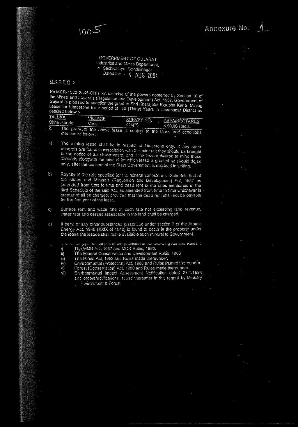
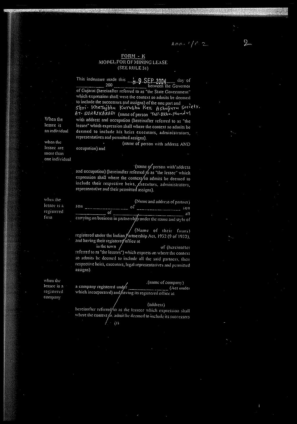
1 PRE-FEASIBILITY REPORT OF VASAI LIMESTONE MINE (APPLICANT: SHRI KHERAJBHA KARUBHA KER) 1. EXECUTIVE SUMMARY: The existing Mining lease for mineral Limestone over Hectares for a period of thirty year was granted to Shri Kherajbha Karubha Ker in survey No. 424(P) in village Vasai, Taluka Okhamandal, District Devbhumi Dwarka, State Gujarat vide letter No. MCR CHH, dated 9 th August 2004 by the Government of Gujarat (Annexure-1) for a period of 30 year. The lease was executed on 9 th September Therefore, the lease period for 30 year is effective from 9 th September 2004 to 8 th September The date of opening is The lease area (4.90 Hectare) comprises Govt. waste Land type. The Scheme of mining with PMCP was approved under rule 13(3) of MCDR 1988 for working mine from the office of Regional Controller of Mine, Indian Bureau of Mines; vide letter number 682(23)(320)/2004 MCCM (N) UDP dated Earlier Scheme of Mining was approved for five year period i.e to The current proposal document is submitted for the next five years period (i.e to ). The mining is proposed by hydraulic excavator and mines is of A- Category (Other than fully mechanized). Lessee is already registered with IBM under rule 45 of MCDR This Review of Mining Plan with Progressive Mine Closure Plan is therefore submitted under rule 17(1) of Minerals (Other than Atomic and Hydro Carbons Energy Minerals) Concession Rules 2016 and rule 23 of MCDR 2017, for competent approval. 2. INTRODUCTION TO THE PROJECT/BACKGROUND INFORMATION: (i) Identification of project and project proponent. In case of mining project, a copy of mining lease/letter of intent should be given. (a) Identification of project The project under reference is a Limestone Mining project having a lease area of 4.90 Ha. Mining is proposed to be done by mechanized open cast method. It 16
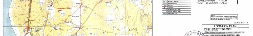
2 issituated near village Vasai intaluka-okhamandal, District Devbhumi Dwarka. It lies on GT Sheet No. 41F/03 and the latitudes and longitudes are given below- Boundary Latitude Longitude Boundary Latitude Longitude Pillar Pillar BP N E BP N E BP-1A N E BP N E BP-1B N E BP N E BP-1C N E BP N E BP N E BP N E BP-2A N E BP N E BP N E BP N E BP-3A N E BP N E BP N E BP N E BP N E BP N E BP N E BP N E BP N E BP N E BP N E (ii) (b) Identification of project proponent: The project proponent ShriKherajbhaKarubha Ker is the proprietor of the firm. (c) Registered Address: Shri Kherajbha Karubha Ker Ashapura Society, Post Surajkaradi, Taluka Okhamandal, District DevbhumiDwarka Contact No Brief description of nature of the project:- As stated above, the project is meant for extraction of Limestone by mechanized open cast method. (iii) Need for the project and its importance to the country and or region:- The limestone has been considered as usable limestone for manufacturing of cement. The limestone produced at the mine in focus for trading only. Both mineral are consumed by cement plan the nearby area. The entire mineral produced irrespective of size is utilized very smartly. This is all for conservation of valuable mineral. The limestone found in the lease area is of cement grade, which are the prime requirement for manufacturing cement. Thus the main buyers of ROM from the lease area are Cement producers in Porbandar area. The Cement grade Limestone is proposed in the use of mineral. Limestone produced at this mine will be sold to nearby industries for manufacturing Cement. The ROM limestone will be directly sold to the client thus no process is updated to suit the user's requirement. No 17
3 other beneficiation is applicable for our limestone as it is to be directly consumed in the same form and composition. The cement grade limestone will directly be fed to cement plants for cement manufacturing unit. Therefore, as such there is no beneficiation process is taking place inside the lease area. (iv) Employment Generation (Direct and Indirect) due to the project: (a) Direct Employment generation 1. Mines Manager 1 2. Geologist 1 3. Skilled Labors 8 4. Semi Skilled 3 5. Unskilled Labors 1 Total 14 (b). Indirect employment generation It is not possible to exactly quantify the in direct employment generation. But the following types of employment opportunity will be generated: i. Engagement of trucks /dumpers for transportation of minerals to the processing units. ii. Development of Hotels and Restaurants to cater to needs of visitors. 3. PROJECT DESCRIPTION: (i) Type of project including interlinked and interdependent projects, if any. There is no interlinked or interdependent project of this mine. (ii) Location (map showing general location, specific location, and project boundary & project site layout) with coordinates. The project site is located near village Vasai in Okhamandal Taluka of Devbhumi Dwarka District, Gujarat. It distance from district Head Quarter Devbhumi Dwarka is about 11Km (Location map is enclosed as plate-2). (iii) Details of alternate sites considered and the basis of selecting the proposed site, particularly the environmental considerations gone into should be highlighted:- Since, mining is a site specific project, it cannot be shifted at will. Its location is dependent on the availability of mineral. All possible measures have been proposed to protect the environment in and around the project. (iv) Size or magnitude of operation:- It is proposed to produce 45,000 Tonnes/ Annum Limestone per year at the mine. Almost all the operations will be mechanized. 18
4 (v) Project description with process details (a schematic diagram/flow chart showing the project layout, components of the project etc. should be given). Extraction of Limestone is proposed to be done by mechanized open cast method. Activities to be carried out in the course of mining are enumerated below:- 1. Reconnaissance survey 2. Removal of soil. 3. Formation of benches. 4. Mineral extraction. 5. Mineral sorting. 6. Loading into trucks and tippers. (vi) Raw material required along with estimated quantity, likely source, marketing area of final product/s, Mode of transport of raw Material and Finished Products. Since, it is a Limestone mining project no raw material will be required for its production. The Limestone produced at the mine will be transported to processing units by dumpers/trucks. HSD is required to be used at the mine for running various mining machineries. (vii) Resource optimization/recycling and reuse envisaged in the project, if any, should be briefly outlined. Not envisaged. Minerals are depleting assets, once mined the same cannot be replenished as in the case of agriculture, vegetation. Thus a scientific approach is necessary for optimal excavation of mineral with minimum wastage. (viii) Availability of water its source, Energy/power requirement and source should be given. Availability of water its source:- The rain fall in the area being about mm, and the nature of rock being permeable up to a certain extent, the ground water is sufficiently recharged with rain water. The area falls under safe category as far as availability of ground water is concerned. The drinking water is obtained through bore wells. Arrangements have been made for storing rain water in mining pits. The stored water will be used for various mining operations like, dust suppression, green belt etc. About 9.0 KLD of water will be required at the project. 19
5 (ix) Energy power:- About 1-2 KLD of HSD will be consumed at the mine daily in order to meet the desired production. The quantity of HSD required will depend upon the rate of production and development done. This may vary from time to time. The HSD is procured directly from the oil marketing companies. Quantity of wastes to be generated (liquid and solid) and scheme for their Management/disposal. (x) No OB/waste will be generated during the course of mining Schematic representations of the feasibility drawing which give information of EIA purpose. As per the MoEF notification dated 14, September 2006 the project falls in B Category. The EIA report is required to be prepared to get environmental clearance for the project from SEIAA, Gujarat. The baseline data has already been collected as mentioned in the schematic diagram. 20
6 Application in Form I-A Along with Feasibility Report & Proposed T.O.R. to SEIAA Monitoring and Baseline data collection Presentation for T.O.R. Baseline Study in core & buffer (1) Micro- Meteorological study (2) Ambient Air Quality (6) Water Quality Hydrology &Hydrogeologycal study (7) Social Economic (3) Noise Vibration Study (4) Land use, Soil & Geological (5) Biological Environment, Flora & (8) Traffic Density Environment (9) Occupational Safety & Health (10) Other Parameters Presentation of Draft EIA/EMP to Environmental Pollution Deptt.for fixation of date of public hearing Conducting Public Hearing Final EIA/EMP Report alongwith incorporating minutes of the meeting of public hearing to SEAC Final Presentation 21
7 4. SITE ANALYSIS: (i) Connectivity: a) By road The lease area is situated near village Vasai, Taluka- Okhamandal& District Devbhumi Dwarka, this mine is situated near state highway 6A at a distance of 4.70 Km. from Dwarka Mithapur Road. b) By Rail The nearest Railway Line is 4.6 Km. away from mine and nearest railway station Dwarka is 13 Km. from the area. (ii) Land Form, Land use and Land ownership. District & State Tehsil Village Type of land Area in Hect. Devbhumi Dwarka (Gujarat) Okhamandal Vasai Govt. Waste Land 4.90 (iii) Physiography: The area exhibits gently flat topography except a small mound of approximate 9 m height from the ground level exists in the South-Western direction of the lease area. The shape of the lease is irregular. The elevation of the area varies between mRL (near pillar BP-8) to 97mRL showing 9.55m difference in relief. The general slope of the area is toward North-West. The list of existing pits inside the lease area. (iv) Existing land use pattern (agriculture, non-agriculture, forest, water bodies (including area under CRZ)), shortest distances from the periphery of the project to periphery of the forests, national park, wild life sanctuary, eco sensitive areas, water bodies (distance from the HFL of the river), CRZ. In case of notified industrial area, a copy of the Gazette notification should be given. There are no Wild life Sanctuaries and National Park within Buffer zone. The area does not fall in CRZ, no eco sensitive zone exist in buffer zone. (v) Existing Infrastructure:-There is a mine office a store room, a rest shelter and a first aid room at the mine. Roads already exist up to the pit top. (vi) Soil classification: The soil available in the area is of Loamy type and it is Slightly Saline. (vii) Climatic data from secondary sources: The climate of the area is semi-arid to arid the climate in the lease area mainly having three seasonal variations as: I. Summer, from February to June, II. Monsoon season, from Jul to September, 22
8 III. Winter, from October to January, The period from March to May is one of continuous increase in temperatures. May is generally the hottest month with a mean daily maximum temperature of January is generally the coldest month with the mean daily maximum temperature of about Winds are generally light to moderate, increasing in strength in later part of summer. The average wind velocity is 11.0 km per hour. Rainfall: The average rain fall ranging 550 to 600 mm per annum between June to September months. (viii) Social Infrastructure available: There is no inhabitation within the lease hold. However, the following Infrastructure exists around the area Police Station : DevbhumiDwarka Post Office : Varvala Educational Facility : Vasai and Varvala Hospital : DevbhumiDwarka 5. PLANNING BRIEF: (i) Planning Concept (type of industries, facilities, transportation etc.) Town and Country Planning/Development authority Classification. Proposed mining method is opencast semi mechanized by forming suitable benches by making height 6m. and width 8m. of benches of as per mining plan. (iii) S.No. Land use planning (break up along with green belt etc.). Detail of land use Existing Land Area in Hectare Proposed Land Total land at the end of fifth year period 1. Area under mining Storage for top soil Waste dump sites Mineral storage Infrastructure - workshop, administrative building etc Roads Railways Tailing pond Effluent Treatment Plant Mineral Separation Plant Township area Green belt/afforestation Grand Total (iv) Assessment of Infrastructure Demand (Physical & Social): 23
9 In case of increase in production in future, widening and consolidation of the existing road will be required. The infrastructure structure like office building, first aid room, rest shelter, etc., already exist at the mine. For social upliftment, necessary facilities will be provided to the local school and religious places. Camps will be arranged in the nearby villages for regular health check up and providing medical help. Training programs will be arranged for making the local people self-dependent. (v) Amenities/Facilities All the amenities and facilities as required under the statutes will be provided at the mine. Since, the workers engaged at the mine come from local villages, they don t require housing facilities. 6. PROPOSED INFRASTRUCTURE: (i) Industrial Area (Processing area): There is no proposal of setting up any processing unit in and around the mining project. (ii) Residential Area (Non Processing Area): Since, the mine workers come from the nearby villages there will be no requirement of developing the residential area. (iii) Green Belt: Greenbelt will be developed over an area of ha within the lease hold on statutory boundary. A total of about 1672 trees will be planted within the greenbelt. (iv) Social Infrastructure: Necessary facilities will be proved to the local schools and religious places for enhancing the standards of education and religious facilities. Medical camps will be arranged periodically for the benefit of the local people. Similarly training facilities will be provided to the local people for making them self-dependent. Drinking water facilities will be provided to the needy villages. (v) Connectivity (Traffic and Transportation Road/Rail/Metro/Water ways etc). a) By road The lease area is situated near village Vasai, Taluka- Okhamandal & District Devbhumi Dwarka, this mine is situated near state highway 6A at a distance of 4.70 Km. from Dwarka Mithapur Road. b) By Rail The nearest Railway Line is 4.6 Km. away from mine and nearest railway station Dwarka is 13 Km. from the area. (vi) Drinking Water management (Source & Supply of water): Drinking water is obtained from a Tube Well. 24
10 (vii) Sewerage System. No sewerage system exists at the mine. (viii) Industrial Waste Management: No industrial waste is generated at the mine. (ix) Solid Waste Management: The solid waste obtained in the form of overburden as well as side burden will be managed by forming dumps over approved the lease hold. Proper retaining wall will be constructed along the toe of the waste dumps to prevent its spreading. Inactive dumps will be vegetated after laying a top soil layer over the waste dumps. (x) Power Requirement & Supply / source. HSD is used at the mine for running the mining machinery etc. About 1 to 2 KLD of HSD will be consumed at the mine daily in order to meet the desired production. The quantity of HSD required will depend upon the rate of production and development done. This may vary from time to time. The HSD is directly from the oil marketing companies. 7. REHABILITATION AND RESETTLEMENT (R & R PLAN): (i) Policy to be adopted (Central/State) in respect of the project affected persons including home oustees, land oustees and landless laborers (a brief outline to be given) No person will be deprived of their homes or land. Thus, there is no need of preparing their rehabilitation and resettlement plan. 8. PROJECT SCHEDULE & COST ESTIMATES: (i) (ii) Likely date of start of construction and likely date of completion (Time schedule for the project to be given). The mine was already in operation. It has been laying closed want of EC. Lease period to Estimated project cost along with analysis in terms of economic viability of the project. The estimated cost of the integrated project is about Rs Crore. 25
11 9. (i) ANALYSTS OF PROPOSAL (FTNAL RECOMMENDATTONS): Financial and social benefits with special emphasis on the benefit to the local people including tribal population, if any, in the area. The existing mining project provides employment opportunity to the residents of nearby villages. It has raised the standard of living of the local people, because their source of income has increased. In due course of time ihe standard of education in the area will improve considerably. Similarly the local people are getting various health facilities from the existing project. They are being dominated by the travel people, the area deriving maximum benefits from the projects. Drinking water facilities will be provided to a number of surrounding villages. Large scale plantation and formation of a large water reservoir in the area will greatly improve the environment of the area. Date: Place: Vasai, Gujarat For: Vasai Limestone Mine (Survey No. 424 Paiki) \ \\-.ec-t \.-- - v--\-! t- c-- \.*- (Shri Kherajbha Karubha Ker) (owner) 26
12

13

14

15
16

17

18
19

20
21

22

23

24
25

26

27
28
29
30
31

32
33

34

35

36

37

38

39

40

41


42
PRE FEASIBILITY REPORT. Quartz and Feldspar Sy No 119 & 126/3, Kambampadu Village A. Konduru Mandal, Krishna District, Andhra Pradesh
 PRE FEASIBILITY REPORT Of Quartz and Feldspar Sy No 119 & 126/3, Kambampadu Village A. Konduru Mandal, Krishna District, Andhra Pradesh Area of Mining Lease 2.720 Ha For 1, 09,055.08 MT/Annum OF Quartz
MCDR INSPECTION General. Date of Inspection Name of the Mine Bhatbhera Limestone Mine 2 Total Lease Area (Ha)
") ::1:: MCDR INSPECTION General SN Particulars Details Date of Inspection 23.8.2015 1 Name of the Mine Bhatbhera Limestone Mine 2 Total Lease Area (Ha) 4.808 Hect (Govt. Revenue Land), Non-forest land with
::1:: MCDR INSPECTION General SN Particulars Details Date of Inspection 23.8.2015 1 Name of the Mine Bhatbhera Limestone Mine 2 Total Lease Area (Ha) 4.808 Hect (Govt. Revenue Land), Non-forest land with
Kurnool vide Proceedings No. 712/Q1/2012 dated Ulindakonda Village, Kallur Mandal, Kurnool District,
 1.0 EXECUTIVE SUMMARY 1.1 Introduction The proposed mining area of 1.157Ha. in survey No. 291 of Ulindakonda Village, Kallur Mandal, Kurnool District has been leased to M/s.Sri Lakshmi Sreenivasa Stone
MCDR INSPECTION REPORT
 MCDR INSPECTION REPORT General S. N. Particulars Details 1 Name of the Mine Matia Limestone Mine 2 Total Lease Area (Ha) with breakup of Non-forest and forest 12.137 Ha. land 3 Mine code 38CHG14086 4 IBM
MCDR INSPECTION REPORT
 MCDR INSPECTION REPORT 1.0 GENERAL SN Particulars Details 1 Name of the inspecting officer J.S. Hada, AMG 2 Date of Inspection 9.9.2017 3 Accompanying mine official Lessee and Mining Engineer Shri K.L.
MCDR INSPECTION REPORT. S. N. Particulars Details 1 Name of the Mine, Inspecting officer with Designation, Date of Inspection
 MCDR INSPECTION REPORT General S. N. Particulars Details 1 Name of the Mine, Inspecting officer with Designation, Date of Inspection Bharuadih Limestone Mine,Rajesh Kumar Das,Sr.ACOM,18.08.2017 2 Total
MCDR INSPECTION REPORT
 MCDR INSPECTION REPORT General S. N. Particulars Details 1 Name of the Mine Matia Limestone Mine 2 Total Lease Area (Ha) with breakup of Non-forest and forest 8.144 ha.,non forest land land 3 Mine code
Table 1.1 Salient Features of the Mine Site & Surrounding Details
 1.0 EXECUTIVE SUMMARY This is a new mining lease allotted by Auction. LOI of Sand Stone Plot. No.- 31, located near Village- Deriya & Pabunagar, Tehsil-Balesar District Jodhpur (Rajasthan) over an area
PRE-FEASIBILITY REPORT
 PRE-FEASIBILITY REPORT (Under the Guidelines of Ministry of Environment and Forest in terms of the provisions of EIA notification 2006 and specifically in circular No J-11013/41/2006-IA.II (I) dated 30
INDIAN BUREAU OF MINES MINERALS DEVELOPMEMT AND REGULATION DIVISION MCDR INSPECTION REPORT. Chennai regional office
 1. Mine file No : (i) Name of the Inspecting : Officer and ID No. INDIAN BUREAU OF MINES MINERALS DEVELOPMEMT AND REGULATION DIVISION TN/TCR/LST-1, MDS (ii) Designation : (iii) Accompaning mine : Official
S.No. Particulars Details 1. Plot. No Name of Mineral Sand Stone 3. Khasra Nos. Details of village wise Khasra details are as: Name of Village
 1.0 EXECUTIVE SUMMARY This is a new mining lease allotted by Auction. LOI of Sand Stone Plot. No.- 65, located near Village Deriya & Pabunagar Tehsil-Balesar, District Jodhpur (Rajasthan) over an area
FOR Sand Stone Quarry Village : Chhirraleva Tehsil : Basna District : Mahasamund
 Project Report FOR Sand Stone Quarry at Village : Chhirraleva Tehsil : Basna District : Mahasamund Contents 1. About the Firm... 1 2. Location of the Project... 1 3. Environmental Setting of Project...
PRE- FEASIBILITY REPORT
 PRE- FEASIBILITY REPORT 16 1.1 EXECUTIVE SUMMARY: The present report pertains to the proposal of Legal Heirs of Late Sh. Ranjeet lal Nalwaya, C/o. M/s. Nalwaya Minerals Industries Pvt. Ltd. for renewal
Geological Report on Limestone Exploration Of Bhatvadiya B Block Of EXECUTIVE SUMMARY
 Geological Report on Limestone Exploration Of Bhatvadiya B Block Of Kalyanpur Taluka, Devbhumi Dwarka District, Gujarat EXECUTIVE SUMMARY Prepared for: Gujarat Mineral Research & Development Society Government
INDIAN BUREAU OF MINES MINERALS DEVELOPMEMT AND REGULATION DIVISION MCDR inspection REPORT Jabalpur regional office
 INDIAN BUREAU OF MINES MINERALS DEVELOPMEMT AND REGULATION DIVISION MCDR inspection REPORT Jabalpur regional office Mine file No : MP/KTN/LST-96 (i) Name of the Inspecting : Officer and ID No. (ii) Designation
PRE FEASIBILITY REPORT OF QUARTZ & FELDSPAR MINING PROJECT (ML No- 80/03) FOR TERMS OF REFERENCE
 FOR TERMS OF REFERENCE") PRE FEASIBILITY REPORT OF QUARTZ & FELDSPAR MINING PROJECT (ML No- 80/03) FOR TERMS OF REFERENCE Village Ashapura Tehsil Nasirabad District Ajmer State Rajasthan Capacity 35945 TPA ROM (Max) Lease Area
PRE FEASIBILITY REPORT OF QUARTZ & FELDSPAR MINING PROJECT (ML No- 80/03) FOR TERMS OF REFERENCE Village Ashapura Tehsil Nasirabad District Ajmer State Rajasthan Capacity 35945 TPA ROM (Max) Lease Area
FORM -1 MINING PLAN & PRE-FEASIBILITY REPORT
 FORM -1 MINING PLAN & PRE-FEASIBILITY REPORT TO OBTAIN ENVIRONMENTAL CLEARANCE FOR QUARRYING OF ROUGH STONE (Extent 1.91.5Ha)-B2 Project IN S.F.No 1257/1 Village Nagamangalam Taluk Denkanikottai District
ANNEXURE I Site Location map of M/s. Stone Plus quarry lease A-1
 ANNEXURE I Site Location map of M/s. quarry lease A-1 Quarry Lease boundary map of M/s. A-2 a. Introduction M/s. proposes to conduct semi mechanized open cast method quarrying for Colour granite extraction
Of Sri. Mohammad Akram. At Karigala Village, H.D. KoteTaluk, Mysore District, Karnataka Latitude & Longitude Piller Latitude Longitude Coordinates
 1.0 EXECUTIVE SUMMARY 1.1 Introduction The proposed mining lease area applied for quarrying of Steatite Stone (soap stone) by Sri. Mohammad Akramis situated in survey no. No. 402of 1-30 Acres of Karigala
Brief Summary. Production = 4,00,000 TPA
 S. NO. ITEMS DETAILS 1 Name of the Project: Dhrang Lime Stone Mine (Survey No 196, 197, 413P) 2 Serial no. in schedule As per EIA Notification dated 14.09.2006 and O.M. dated 24.12.2013, the project activity
Mineral ~ Granite Mining project ~ Category B2 Lease Area ~ 3.00 Ha. Near Village ~ Jotaya Tehsil ~ Sarwar District ~ Ajmer State ~ Rajasthan
 PREFEASIBILITY REPORT Mineral ~ Granite Mining project ~ Category B2 Lease Area ~ 3.00 Ha. Near Village ~ Jotaya Tehsil ~ Sarwar District ~ Ajmer State ~ Rajasthan PROJECT PROPONENT Sh. Vijay Kumar Soni
FOR QUARRYING OF KAGANAM ROUGH STONE AND GRAVEL QUARRY
 PROPOSAL TO OBTAIN ENVIRONMENTAL CLEARANCE FROM District Level Environment Impact Assessment Authority (DEIAA), Tiruvannamalai District, Tamilnadu FOR QUARRYING OF KAGANAM ROUGH STONE AND GRAVEL QUARRY
FORM -1 MINING PLAN & PRE-FEASIBILITY REPORT FOR QUARRYING OF BLACK GRANITE
 FORM -1 MINING PLAN & PRE-FEASIBILITY REPORT TO OBTAIN ENVIRONMENTAL CLEARANCE FOR QUARRYING OF BLACK GRANITE (Extent 2.3.0Ha)-B2 Project IN S.F.Nos 248/2 (P), 248/1A (P), 248/1B(P) and 248/1C (P) Village
Report for Area Drainage Studies for 1320 MW (2x660 MW) THERMAL POWER PROJECT AT MIRZAPUR, U.P.
 THERMAL POWER PROJECT AT MIRZAPUR, U.P.") Report for Area Drainage Studies for 1320 MW (2x660 MW) THERMAL POWER PROJECT AT MIRZAPUR, U.P. 1. Introduction M/s Welspun Energy Uttar Pradesh Ltd. (WEUPL) is putting up 1320 MW (2 x 660 MW) coal fired
Report for Area Drainage Studies for 1320 MW (2x660 MW) THERMAL POWER PROJECT AT MIRZAPUR, U.P. 1. Introduction M/s Welspun Energy Uttar Pradesh Ltd. (WEUPL) is putting up 1320 MW (2 x 660 MW) coal fired
EMP. In respect of. Cluster of Two Mines (Cluster area Ha)
") M/s. NSC Consortium, Road Metal Mine 12.146 Ha. EMP In respect of Cluster of Two Mines (Cluster area 22.146 Ha) AT Sy. No. 734/P, Yadavalli Village, Dornala Mandal, Prakasam district, Andhra Pradesh Cluster
M/s. NSC Consortium, Road Metal Mine 12.146 Ha. EMP In respect of Cluster of Two Mines (Cluster area 22.146 Ha) AT Sy. No. 734/P, Yadavalli Village, Dornala Mandal, Prakasam district, Andhra Pradesh Cluster
Granite Building Stone Quarry of Sri. Sajan Mani.
 1. EXECUTIVE SUMMARY: Sri. Sajan Mani had made an application for Granite building stone quarrying located in Sy. No. 2398, Peechi Village, Thrissur Taluk, Thrissur District, Kerala State. Over an extent
Social Studies Grade 2 - Building a Society
 Social Studies Grade 2 - Building a Society Description The second grade curriculum provides students with a broad view of the political units around them, specifically their town, state, and country.
Local Area Key Issues Paper No. 13: Southern Hinterland townships growth opportunities
 Draft Sunshine Coast Planning Scheme Review of Submissions Local Area Key Issues Paper No. 13: Southern Hinterland townships growth opportunities Key Issue: Growth opportunities for Southern Hinterland
Granite Building Stone Quarry of M/s Ulikkal Stone Crusher
 1. EXECUTIVE SUMMARY: M/s. Ulikkal Stone Crusher had made an application for Granite building stones quarrying located in Sy. No. 28/1A2 in Vayathur Village, Iritty taluk, Kannur District, Kerals State.
PRE FEASIBILITY REPORT
 PRE FEASIBILITY REPORT TABLE OF CONTENTS Sr. No. Content Page No. 1.0 Executive Summary 25 2.0 Introduction of Project / Background Information 26 3.0 Project Description 28 4.0 Site Analysis 33 5.0 Planning
APPLICANT: MD. SARFARAZ ANSARI & VIVEKA NAND RAY PRE FEASIBILITY REPORT PRE- FEASIBILITY REPORT
 PRE- FEASIBILITY REPORT 0 CONTENTS EXECUTIVE SUMMARY... 3 1.0 INTRODUCTION... 3 1.1 SALIENT FEATURES OF THE PROJECT... 4 1.2 PRESENT LAND USE PLAN... 5 1.3 PROPOSED PLANNING... 5 1.4 UTILIZATION... 5 2.
PRE FEASIBILITY REPORT
 PRE FEASIBILITY REPORT TABLE OF CONTENTS Sr. No. Content Page No. 1.0 Executive Summary 29 2.0 Introduction of Project / Background Information 30 3.0 Project Description 32 4.0 Site Analysis 39 5.0 Planning
MCDR INSPECTION REPORT hect. (All Non-forest) IBM/4816/2011
 IBM/4816/2011") MCDR INSPECTION REPORT 1.0 GENERAL SN Particulars Details 1 Name of the Mine, Name of Inspecting officer with designation and date of inspection 2 Total Lease Area (Ha) with breakup of Non-forest and forest
MCDR INSPECTION REPORT 1.0 GENERAL SN Particulars Details 1 Name of the Mine, Name of Inspecting officer with designation and date of inspection 2 Total Lease Area (Ha) with breakup of Non-forest and forest
TABLE OF CONTENTS. 1.0 Introduction. 2.0 Geology, Exploration and Reserves. 3.0 Mining. 4.0 Blasting. 5.0 Mine Drainage. 6.
 TABLE OF CONTENTS 1.0 Introduction 2.0 Geology, Exploration and Reserves 3.0 Mining 4.0 Blasting 5.0 Mine Drainage 6.0 Site Services 1.0 INTRODUCTION Pankaj Chandrakar a resident oftemri, P.O. Deopuri
2 INTRODUCTION OF THE PROJECT/BACKGROUND INFORMATION:
 1. EXECUTIVE SUMMARY The proposed mining project is located near Mauza & Mohal Lodhwan/Pail, Tehsil Nurpur, District Kangra, Himachal Pradesh. The proposed project is of sand, stone and bajri mining having
MINING PLAN FORMAT (A & B CATEGORY MINES) As per MCDR,1988
 As per MCDR,1988") MINING PLAN FORMAT (A & B CATEGORY MINES) As per MCDR,988 INTRODUCTORY NOTES. 'A' category mines : all mines excluding 'B' Category mines. B' category mines : all 'B' Category mines excluding very small
MINING PLAN FORMAT (A & B CATEGORY MINES) As per MCDR,988 INTRODUCTORY NOTES. 'A' category mines : all mines excluding 'B' Category mines. B' category mines : all 'B' Category mines excluding very small
Pre-Feasibility Report of Multi-Coloured Granite Quarry
 Pre-Feasibility Report of Multi-Coloured Granite Quarry (Under the Guidelines of Ministry of Environment and Forest in terms of the provisions of EIA notification 20051, 52 & 127 and specifically in circular
JAI MAA SHARDA STONE CRUSHING
 JAI MAA SHARDA STONE CRUSHING Prop. Hukum Singh (M. No. 9425585252) Near-Pahunadukan Kedarpur Ambikapur, (C.G.) To, The Member Secretary, SLEIAA(State Level Environment Impact Assessment Authority), Ministry
Geological Report on Limestone Exploration of Mudhvay Sub-block B, Lakhpat Taluka, Kachchh District, Gujarat. Executive Summary
 Geological Report on Limestone Exploration of Mudhvay Sub-block B, Lakhpat Taluka, Kachchh District, Gujarat Executive Summary Prepared for Commissioner of Geology & Mining Government of Gujarat Prepared
Oposura Scoping Study Nearing Completion
 20 AUGUST 2018 KEY POINTS: Oposura Scoping Study Nearing Completion Mining study with open pit optimisations and underground mine designs completed High grade massive sulphide mineralisation occurs near
Geological Report on Limestone Exploration of Mudhvay Sub-block A, Lakhpat Taluka, Kachchh District, Gujarat. Executive Summary
 Geological Report on Limestone Exploration of Mudhvay Sub-block A, Lakhpat Taluka, Kachchh District, Gujarat Executive Summary Prepared for Commissioner of Geology & Mining Government of Gujarat Prepared
FIELD MONITORING OF STABILITY OF DUMP A CASE STUDY
 FIELD MONITORING OF STABILITY OF DUMP A CASE STUDY Dr. Singam Jayanthu*, and Dr. Simantini Behera** Professor, Associate Professor Department of Mining Engineering National Institute of Technology Rourkela-769008
APPLICANT: M/s. Rock Sand & Minerals Pvt Ltd PRE-FEASIBILITY REPORT
 PRE- FEASIBILITY REPORT 1.1 Introduction EXECUTIVE SUMMARY The proposed mining lease of 19.80ha in survey no. 345 was granted to M/s. Rock Sand Minerals Pvt Ltd, for a period of 15 years by Asst. Director
ANNEXURE-I (AS PER FORMAT ISSUED BY BIHAR-SEIAA)
") ANNEXURE-I (AS PER FORMAT ISSUED BY BIHAR-SEIAA) ANNEXURE-II (AS PER FORMAT ISSUED BY BIHAR-SEIAA) ANNEXURE-III LETTER OF INTENT Scanned by CamScanner Scanned by CamScanner Scanned by CamScanner
ANNEXURE-I (AS PER FORMAT ISSUED BY BIHAR-SEIAA) ANNEXURE-II (AS PER FORMAT ISSUED BY BIHAR-SEIAA) ANNEXURE-III LETTER OF INTENT Scanned by CamScanner Scanned by CamScanner Scanned by CamScanner
PRE - FEASIBILITY REPORT Shri Santosh Kumar Dwivedi S/o Shri Goverdhan Dwivedi R/o Village Adampur Saibasi Majre
 1. EXECUTIVE SUMMARY PRE - FEASIBILITY REPORT Shri Santosh Kumar Dwivedi S/o Shri Goverdhan Dwivedi R/o Village Adampur Saibasi Majre Sarkandi, Tehsil and District - Fatehpur, Uttar Pradesh is the lessee
Bishkek City Development Agency. Urban Planning Bishkek
 Bishkek City Development Agency Urban Planning Bishkek Bishkek City Development Agency Official name City budget Population Area GRP Import value Export value External trade turnover Foreign direct investments
THE MINISTRY OF ENERGY AND ENERGY INDUSTRIES MINERALS DIVISION MINE DESIGN TEMPLATE OPERATOR NAME: OPERATOR ADDRESS: PHONE NUMBER: FACSIMILE:
 THE MINISTRY OF ENERGY AND ENERGY INDUSTRIES MINERALS DIVISION MINE DESIGN TEMPLATE 1.0 GENERAL INFORMATION OPERATOR NAME: OPERATOR ADDRESS: PHONE NUMBER: FACSIMILE: NAME OF CONTACT: CELLULAR PHONE: EMAIL
Georeferencing and Satellite Image Support: Lessons learned, Challenges and Opportunities
 Georeferencing and Satellite Image Support: Lessons learned, Challenges and Opportunities Shirish Ravan shirish.ravan@unoosa.org UN-SPIDER United Nations Office for Outer Space Affairs (UNOOSA) UN-SPIDER
Submitted to Central Coalfields Limited BHURKUNDA OCP, CCL
 Land Restoration / Reclamation Monitoring of Open Cast Coal Mines of Central Coalfields Limited producing less than 5 m cu m. (Coal+ OB) based on Satellite Data for the Year 2013 BHURKUNDA OCP, CCL Submitted
Submitted to: Central Coalfields Limited Ranchi, Jharkhand. Ashoka & Piparwar OCPs, CCL
 Land Restoration / Reclamation Monitoring of more than 5 million cu. m. (Coal + OB) Capacity Open Cast Coal Mines of Central Coalfields Limited Based on Satellite Data for the Year 2013 Ashoka & Piparwar
Data Collection. Lecture Notes in Transportation Systems Engineering. Prof. Tom V. Mathew. 1 Overview 1
 Data Collection Lecture Notes in Transportation Systems Engineering Prof. Tom V. Mathew Contents 1 Overview 1 2 Survey design 2 2.1 Information needed................................. 2 2.2 Study area.....................................
Typical information required from the data collection can be grouped into four categories, enumerated as below.
 Chapter 6 Data Collection 6.1 Overview The four-stage modeling, an important tool for forecasting future demand and performance of a transportation system, was developed for evaluating large-scale infrastructure
Location of the Quarry
 Pre-Feasibility Report of Black Granite (Dolerite) quarry (Under the Guidelines of Ministry of Environment and Forest in terms of the provisions of EIA notification 20051, 52 & 127 and specifically in
Meghalaya. Mining their own business. Arwat Challam
 Meghalaya Mining their own business Arwat Challam Introduction Area of 22,429 sq. km. Divided into 7 Districts Meghalaya Three Main tribes- Khasi, Pnar and Garo Indo-Malayan Biodiversity Hotspot. Major
Foreword. Vision and Strategy
 GREATER MANCHESTER SPATIAL FRAMEWORK Friends of Walkden Station Consultation Response January 2017 Foreword Friends of Walkden Station are a group of dedicated volunteers seeking to raise the status and
WHAT IS MINERAL EXPLORATION?
 INDABA PRESENTATION CAPE TOWN FEBRUARY 2017 AIM:SAV WHAT IS MINERAL EXPLORATION? AIM:SAV What is mineral exploration? 2 Exploration is the term used to describe a wide range of activities aimed at searching
UNIVERSITY OF CAMBRIDGE INTERNATIONAL EXAMINATIONS International General Certificate of Secondary Education
 UNIVERSITY OF CAMBRIDGE INTERNATIONAL EXAMINATIONS International General Certificate of Secondary Education *9751541575* GEOGRAPHY 0460/23 Paper 2 October/November 2011 Candidates answer on the Question
M/s.Harshad Granites,
 FORM -1 M (I) Basic Information S.NO. Item Details (i) Name of the Mining Lease Site M/s.Harshad Granites, Irapuram Village, Kunnathundu Taluk, Ernakulam District (ii) Location/site Topo sheet : 58/B12
INDIAN BUREAU OF MINES MINERALS DEVELOPMEMT AND REGULATION DIVISION MCDR INSPECTION REPORT. Bangalore regional office
 1. Mine file No : (i) Name of the Inspecting : Officer and ID No. INDIAN BUREAU OF MINES MINERALS DEVELOPMEMT AND REGULATION DIVISION KNT/CTD/LST/19/BNG (ii) Designation : (iii) Accompaning mine : Official
Geological report on Limestone Exploration of Goyla Block, Abadasa Taluka, Kachchh District, Gujarat. Executive Summary
 Geological report on Limestone Exploration of Goyla Block, Abadasa Taluka, Kachchh District, Gujarat Executive Summary Prepared for Commissioner of Geology & Mining Government of Gujarat Prepared by Geovale
Most people used to live like this
 Urbanization Most people used to live like this Increasingly people live like this. For the first time in history, there are now more urban residents than rural residents. Land Cover & Land Use Land cover
UNIVERSITY OF CAMBRIDGE INTERNATIONAL EXAMINATIONS International General Certificate of Secondary Education
 UNIVERSITY OF CAMBRIDGE INTERNATIONAL EXAMINATIONS International General Certificate of Secondary Education * 6 2 6909951 3 * GEOGRAPHY 0460/22 Paper 2 May/June 2010 Candidates answer on the Question Paper.
Chapter 10 Human Settlement Geography Book 1 Class 12
 CHAPTER 10 HUMAN SETTLEMENTS 1. RURAL, SUB URBAN AND URBAN SETTLEMENTS: This classification is common worldwide but the criteria differ from country to country. 5. Criteria for classification differs from
PRE FEASIBILITY REPORT. Kuppilli, Koyyam, Dharmavaram, Village Bonthalakoduru villages Mandal Etcherla District Srikakulam State Andhra Pradesh
 1) Executive Summary Project Name of Company / Mine Owner Location PRE FEASIBILITY REPORT Kuppli- Koyyam Mineral Sands Deposit-I, Pre-concentration Plant (PCP). M/s. Andhra Pradesh Mineral Development
PRE-FEASIBILITY REPORT
 PRE-FEASIBILITY REPORT FOR Stone/Sand/Bajri Mine (With ML Area of 1.9507 Ha) Kh. No. 5822/5771/1, 632/1, 922/1, 923/1, Chullah, Patwar Circle Chullah, Ladhbarol, Mandi Himachal Pradesh M/s Beas Valley
Social Science Holidays Homework Class 8 th
 Social Science Holidays Homework Class 8 th Projects For summer Vacations;- 1. Make a project on the topic Tribals, Dikus and the vision of a Golden age using the following guide points:- (a) Tribal occupation
CONTENTS. and 62 of MCDR Flow Diagram for Notice of opening of mine under Rule 20, 2.1 Rule - 18 Beneficiation studies to be carried out 11
 Part NO. CONTENTS CHAPTER I Flow Diagram for Rule 20, 21, 28, 30, 35, 45, 49, 50, 51 and 62 of MCDR 2017 1.1 Flow Diagram for Notice of opening of mine under Rule 20, PAGE NO. 1 MCDR 2017 1.2 Flow diagram
CERTIFIED RESOLUTION. introduction: and dated May 29, 2017, as attached, as appropriate
 15322 Buena Vista Avenue, White Rock BC, Canada V4B 1Y6 www.whiterockcity.ca City of White Rock P: 604.541.22121 F: 604.541.9348 /2tC% City Clerk s Office IT E ROC K June 13,2017 Stephanie Lam, Deputy
GOVERNMENT OF MADHYA PRADESH WATER RESOURCES DEPARTMENT HANOTA MAJOR PROJECT PRE FEASIBILITY REPORT. ESTIMATED COST : Rs
 GOVERNMENT OF MADHYA PRADESH WATER RESOURCES DEPARTMENT HANOTA MAJOR PROJECT PRE FEASIBILITY REPORT ESTIMATED COST : Rs. 1392.42 Crores DESIGNED IRRIGATION : 40000 Ha. COST PER HACT. : Rs. 3.48 Lakhs ''EVERY
Legal problems of environmental management. Spatial planning and space management. M. Gajewski 2014 / 2015
 Legal problems of environmental management Spatial planning and space management M. Gajewski 2014 / 2015 Course contents (in brief) Constitutional basis of the environment protection system. General principles
Minnesota K-12 Academic Standards in Social Studies. Grade 4: Geography of North America
 Minnesota K-12 Academic s in Social Studies Grade 4: Geography of North America 4 Describe how people take 1. Democratic government action to influence a depends on informed and decision on a specific
Economic Geography of the Long Island Region
 Geography of Data Economic Geography of the Long Island Region Copyright 2011 AFG 1 The geography of economic activity requires: - the gathering of spatial data - the location of data geographically -
1.0 EXECUTIVE SUMMARY
 1.0 EXECUTIVE SUMMARY The proposed Granite Mine (Minor Mineral) of Lessee Sh. Devendra Singh S/o Sh. Kailash Singh is situated near village Mungeriya, Tehsil - Shiv, District - Barmer, Rajasthan over an
SITE SELECTION CRITERIA FOR A SOLAR PV PLANT. Under The Guidence of SOHEL PATEL
 SITE SELECTION CRITERIA FOR A SOLAR PV PLANT Under The Guidence of SOHEL PATEL CONTENTS Introduction Selection of land 1.area longitude & latitude 2.quality of soil 3.soil test report 4.Terrain & contours
PW 001 SNOW REMOVAL AND SANDING FOR ROADWAYS AND SIDEWALKS October 6, 2014 (#223-14) Original October 19, 2015; October 15, 2018 Public Works
 Original October 19, 2015; October 15, 2018 Public Works") Policy Statement: The Village of Kitscoty will provide snow and ice control on municipal streets and sidewalks according to determined priorities. Purpose: To provide direction and information to employees
Policy Statement: The Village of Kitscoty will provide snow and ice control on municipal streets and sidewalks according to determined priorities. Purpose: To provide direction and information to employees
The National Spatial Strategy
 Purpose of this Consultation Paper This paper seeks the views of a wide range of bodies, interests and members of the public on the issues which the National Spatial Strategy should address. These views
MAP STUDY: INTERPRETATION OF SURVEY MAPS
 MAP STUDY: INTERPRETATION OF SURVEY MAPS Types and Elements of Maps Maps are drawn to represent the Earth on a piece of paper. Maps are used widely to represent the Earth. Maps use signs and symbols in
about GCC
 about GCC Bldg 234, Flat 11, Al Barakat Street, Hail Al Janaubiyah P.O Box: 94, Postal Code: 123, Al Khaudh, Sultante of Oman Fax : +968 24543188 Mobile :+968 96666445 info@gcc-oman.com www.gcc-oman.com
COMMUNITY SERVICE AREA
 INSTITUTE FOR TRIBAL ENVIRONMENTAL PROFESSIONALS Tribal Waste and Response Assistance Program (TWRAP) Developing and Implementing a Tribal Integrated Solid Waste Management Plan April 12-14, 2016 Palm
Flood Scenario Worksheet
 Flood Scenario Worksheet Scenario adapted from: http://www.epa.gov/watersecurity/tools/trainingcd/simple/source/scenario-8/ssc8-0.pdf Simple Tabletop Exercise, Interdependency Natural Disaster Scenario,
The AIR Bushfire Model for Australia
 The AIR Bushfire Model for Australia In February 2009, amid tripledigit temperatures and drought conditions, fires broke out just north of Melbourne, Australia. Propelled by high winds, as many as 400
Study of Hydrometeorology in a Hard Rock Terrain, Kadirischist Belt Area, Anantapur District, Andhra Pradesh
 Open Journal of Geology, 2012, 2, 294-300 http://dx.doi.org/10.4236/ojg.2012.24028 Published Online October 2012 (http://www.scirp.org/journal/ojg) Study of Hydrometeorology in a Hard Rock Terrain, Kadirischist
CLAREMONT MASTER PLAN 2017: LAND USE COMMUNITY INPUT
 Planning and Development Department 14 North Street Claremont, New Hampshire 03743 Ph: (603) 542-7008 Fax: (603) 542-7033 Email: cityplanner@claremontnh.com www.claremontnh.com CLAREMONT MASTER PLAN 2017:
GIS Geographical Information Systems. GIS Management
 GIS Geographical Information Systems GIS Management Difficulties on establishing a GIS Funding GIS Determining Project Standards Data Gathering Map Development Recruiting GIS Professionals Educating Staff
PRE FEASIBILITY REPORT
 PRE FEASIBILITY REPORT 1. INTRODUCTION Thiru S. Baskar Babu, S/o. Late Sri S. Selvaraj, No.2, First cross street, Anna Nagar, Nellithope S.O., Pondicherry has a mining lease area for the production of
Geography Class XI Fundamentals of Physical Geography Section A Total Periods : 140 Total Marks : 70. Periods Topic Subject Matter Geographical Skills
 Geography Class XI Fundamentals of Physical Geography Section A Total Periods : 140 Total Marks : 70 Sr. No. 01 Periods Topic Subject Matter Geographical Skills Nature and Scope Definition, nature, i)
An Introduction to Field Explorations for Foundations
 An Introduction to Field Explorations for Foundations J. Paul Guyer, P.E., R.A. Paul Guyer is a registered mechanical engineer, civil engineer, fire protection engineer and architect with over 35 years
Pre-feasibility Report of Multi - Colour Granite Quarry
 Pre-feasibility Report of Multi - Colour Granite Quarry (Under the Guidelines of Ministry of Environment and Forest in terms of the provisions of EIA notification 20051, 52 & 127 and specifically in circular
Guidelines for preparation of Mining Plans for Coal/Lignite Blocks
 Guidelines for preparation of Mining Plans for Coal/Lignite Blocks Annexure The following guidelines are issued for preparation of mining plans for coal/lignite block development by the block holders.
Roadway Traffic Noise Feasibility Assessment. 315 Chapel Street. Ottawa, Ontario
 Roadway Traffic Noise Feasibility Assessment 315 Chapel Street Ottawa, Ontario REPORT: GWE17-002 - Traffic Noise Prepared For: Leanne Moussa Allsaints 10 Blackburn Avenue K1N 6P8 Ottawa, Ontario Prepared
Request for Empanelment
 Request for Empanelment (Empanelment is method/procedure/way to seek technical & financial or financial quotation from eligible firm/organization/academic institute to short list eligible contender for
KENTUCKY HAZARD MITIGATION PLAN RISK ASSESSMENT
 KENTUCKY HAZARD MITIGATION PLAN RISK ASSESSMENT Presentation Outline Development of the 2013 State Hazard Mitigation Plan Risk Assessment Determining risk assessment scale Census Data Aggregation Levels
Yaneev Golombek, GISP. Merrick/McLaughlin. ESRI International User. July 9, Engineering Architecture Design-Build Surveying GeoSpatial Solutions
 Yaneev Golombek, GISP GIS July Presentation 9, 2013 for Merrick/McLaughlin Conference Water ESRI International User July 9, 2013 Engineering Architecture Design-Build Surveying GeoSpatial Solutions Purpose
Electronic Submission Format Guide Anthracite Preparation Plant Permit Application
 Electronic Submission Format Guide Anthracite Preparation Plant Permit Application Module 1: Application Section A through Section J, the Application Checklist, and all narrative responses Act 67 / 68
Regional Snapshot Series: Transportation and Transit. Commuting and Places of Work in the Fraser Valley Regional District
 Regional Snapshot Series: Transportation and Transit Commuting and Places of Work in the Fraser Valley Regional District TABLE OF CONTENTS Complete Communities Daily Trips Live/Work Ratio Commuting Local
HAZUS-MH: Earthquake Event Report
 HAZUS-MH: Earthquake Event Report Region Name: El Paso County Earthquake Scenario: El Paso County Random EQ Print Date: February 08, 2006 Disclaimer: The estimates of social and economic impacts contained
Understanding China Census Data with GIS By Shuming Bao and Susan Haynie China Data Center, University of Michigan
 Understanding China Census Data with GIS By Shuming Bao and Susan Haynie China Data Center, University of Michigan The Census data for China provides comprehensive demographic and business information
(3) The consent letter/declaration/undertaking may have uniform signature of the lessee.
 The consent letter/declaration/undertaking may have uniform signature of the lessee.") Annexure SCRUTINY COMMENTS ON THE DRAFT REVIEW OF MINING PLAN AND PMCP OF RAJABERA IRON ORE MINE (41.697 HA.) OF SHRI PADAM KUMAR JAIN LOCATED IN SINGHBHUM (WEST) DISTRICT, JHARKHAND SUBMITTED UNDER RULE
Annexure SCRUTINY COMMENTS ON THE DRAFT REVIEW OF MINING PLAN AND PMCP OF RAJABERA IRON ORE MINE (41.697 HA.) OF SHRI PADAM KUMAR JAIN LOCATED IN SINGHBHUM (WEST) DISTRICT, JHARKHAND SUBMITTED UNDER RULE
A Review of Concept of Peri-urban Area & Its Identification
 A Review of Concept of Peri-urban Area & Its Identification Ar. Manita Saxena Research Scholar Department of Architecture and Planning M.A.N.I.T, Bhopal Dr. Supriya Vyas Assistant Professor, Department