ANNEXURE-I (AS PER FORMAT ISSUED BY BIHAR-SEIAA)
|
|
|
- Sara Paul
- 5 years ago
- Views:
Transcription
1 ANNEXURE-I (AS PER FORMAT ISSUED BY BIHAR-SEIAA)
2
3
4 ANNEXURE-II (AS PER FORMAT ISSUED BY BIHAR-SEIAA)
5
6
7
8
9 ANNEXURE-III LETTER OF INTENT

10 Scanned by CamScanner

11 Scanned by CamScanner

12 Scanned by CamScanner
13 ANNEXURE-IV CLIENT & CONSULTANT AFFIDAVIT
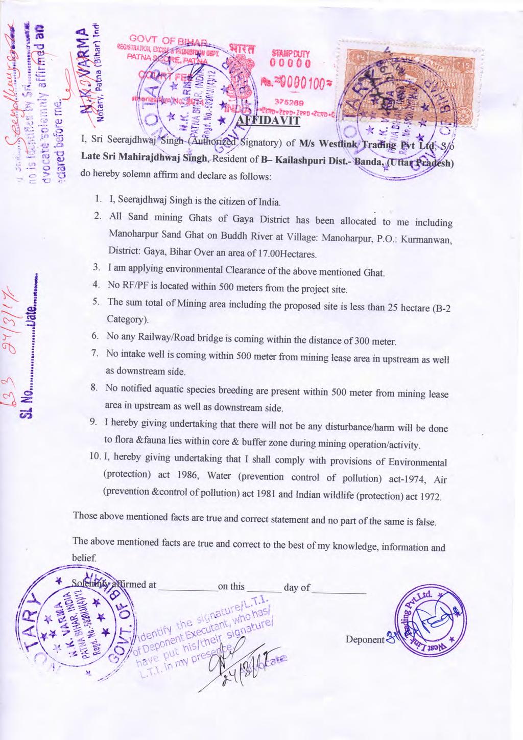
14

15
16 ANNEXURE-V 1 Km & 500 METER RADIUS GOOGLE MAP

17
18 ANNEXURE-VI NRSC MAP

19
20 ANNEXURE-VII COMPOSITE MAP


21
22 ANNEXURE-VIII HAUL ROAD MAP

23
24 ANNEXURE-IX SURFACE PLAN
25
26 ANNEXURE-X EMP PLAN
27
28 ANNEXURE-XI DEVELOPMENTAL PLAN
29
30 ANNEXURE-XII GEOLOGICAL PLAN
31
32 ANNEXURE-XIII MINE PLAN
 APPLICANT: M/S WESTLINK TRADING PVT. LTD. KAILASHPURI, BANDA (U.P) Prepared By: ER. PRAVIN KR SINHA RQP/JBP/129/2011/A Validity up to 10 TH May, 2021")
33 WITH PROGRESSIVE MINE CLOSURE PLAN OF GAYA SAND MINING PROJECT DISTRICT-GAYA (BIHAR) APPLIED AREA = HECTARES (Non Forest land = HECTARES) APPLICANT: M/S WESTLINK TRADING PVT. LTD. KAILASHPURI, BANDA (U.P) Prepared By: ER. PRAVIN KR SINHA RQP/JBP/129/2011/A Validity up to 10 TH May, 2021
34 AUTHORISATION LETTER BY THE SETTLEE M/s Westlink Trading Pvt. Ltd., Kailashpuri, Banda (U.P) hereby authorise to Er. Pravin Kr. Sinha RQP No. RQP/JBP/129/2011/A to prepare the Modified Mining Plan as per schedule- IV; Rule No 6 of the Bihar Minor Mineral Concession (Amendment) Rule 2014 in respect of Gaya sand Deposit in District Gaya, state Bihar. I request to the Director, Directorate of Mining & Geology, Bihar to make further correspondence regarding modification and to collect the approved copies of the aforesaid Mining Plan with the said recognized person on his following address: Name of RQP Er. Pravin Kr. Sinha Registration No : RPQ/JBP/129/2011/A Validity : Address of RQP 201, Mangal Market Raja Bazar, Patna, Bihar Phone No : & E mail : pravinsinha01@yahoo.com Place: Gaya Date: Your s Faithfully
35 CONTENT S.NO. PARTICULARS PAGE NO. 1. EXECUTIVE SUMMARY 1 2. INTRODUCTION 2 3. PROJECT DESCRIPTION 3 4. LOCATION, GENERAL AND ACCESSIBILITY 7 5. GEOLOGY & EXPLORATION MINING DRILLING AND BLASTING WATER DRAINAGE SYSTEM DISPOSAL OF WASTE MATERIAL USE OF MINERAL OTHER MINERAL BENEFICIATION ENVIRONMENT MANAGEMENT PLAN CONCLUSION PROGRESSIVE MINE CLOSURE PLAN 1-15
36 LIST OF ANNEXURES ANNEXURE NO. NAME OF ANNEXURE 1 COPY OF LETTER OF INTENT 2 COPY OF RQP CERTIFICATE 3 KHASRA MAP 4 SITE PHOTOGRAPHS 5 APPROVAL LETTER LIST OF PLATES PLATE NO. LIST OF PLATES 1 LOCATION PLAN 2 KEY PLAN 2A COMPOSITE PLAN 3 A to 153 A SURFACE GEOLOGICAL PLAN 3 B to 153 B GEOLOGICAL SECTION 3 C to 153 C YEARWISE DEVELOPMENT PLAN 3 D to 153 D CONCEPTUAL PLAN 3 E to 153 E PROGRESSIVE MINE CLOSURE PLAN
37 LIST OF TABLES S. No. DESCRIPTION TABLE NO. 1. Coordinates of all stretches of each blocks 1 2. Geological Reserves of each Stretches 2-A to 2-J 3. Mineable Reserves of each Stretches 4 4. Socioeconomic details of Gaya District 5
38
39 Gaya Sand Mining Project Modified Mine Plan Executive Summary: The proposed mining area is of = Ha (i.e Hectares as per approved mine plan & Hectares as per newly added sand ghats shown in plan). Mining lease area is located as block in all rivers/ Stretches of Gaya district. Mining plan has been earlier approved on Lease area is granted for five years in favour of M/s West Link Trading Pvt Ltd. The project is operated as open cast semi-mechanized method. Mining settlee is entitled to shall get a modification of Mining Plan as per schedule- IV; clause No. 6 of the Bihar Minor Mineral Concession (Amendment) Rule The need of Modification in mine plan are due to following reasons:- 1. The flow characteristics of the river i.e. velocity of water flow and gradient of the river bed both have deviated and altered due to natural changes in the river ecosystem. 2. The natural changes in the flow characteristics of flow pattern (as described above) have induced changes in the direction of water flow of the river causing decrease in sand reserves and shift in places of deposition of sand in natural ways. 3. There are some changes in co-ordinates which need to be modified for obtaining EC from competent authority. 4. For Sand Blocks Sr. no (2),(15),(28),(30),(46),(50),(54),(55)&(58) co ordinates require modification for which the Mine Plan was approved earlier. 5. Now a days and in recent years, infrastructure works are in its peak. Being main construction material in any type of construction work, sand is required. Hence its market demand has also gone up substantially. 6. Project locations have been selected as par necessary enquired distances from the dwelling units or villages. The direct impacts will be on transportation cost. It can be minimized by keeping such sand Ghats nearer to populated area. The access to sand ghat and it transportation cost up to time of mineral to market can be thus reduced for its availability nearly populated sites. 7. Some of the sand ghats have been identified having sand deposits which were distant apart previously due to various reasons. 8. Therefore, owing to above cited natural reasons the present Modifications in the Mine Plan have been made and presented for approval freshly under the Bihar Minor Mineral Concession (Amendment) Rules, vide Gazette notification no 4/ wi.mu / /M dated 3 September 2014 in the light of Schedule IV sr. no 6 (ia) to (ib) and sr. no (iii) page 19 of the aforesaid notification. 1 Prepared by: Pravin Kr. Sinha, Regd. No. RQP/JBP/129/2011/A
40 Gaya Sand Mining Project Modified Mine Plan PART A CHAPTER 1 1. INTRODUCTION 1.1 Applicant Name & Full address M/s Westlink Trading Pvt. Ltd. Kailashpuri, Banda (U.P) Phone. No. ID 1.2 Applicant's post/social status Private 1.3 Mineral or Minerals which the applicant intends to mine & westlink@rediffmail.com Sand 1.4 Applied area for mining lease Gaya (Sand Deposits having an area of 1.5 Name & address of RQP & Regd. No. Mobile No. ID = Ha. State Govt. has given its consent to grant mining lease vide letter no. 399/Khanan, Gaya, dated 28/3/15 Copy of letter is enclosed as Annexure No.1. Er. Pravin Kr Sinha 201,Mangal Market Raja Bazar, Patna RQP : RQP/JBP/129/2011/A & pravinsinha01@yahoo.com 1.6 RQP Certificate RQP certificate copy attached as Annexure 2, which is valid up to Prepared by: Pravin Kr. Sinha, Regd. No. RQP/JBP/129/2011/A
41 Gaya Sand Mining Project Modified Mine Plan CHAPTER 2 2. PROJECT DESCRIPTION 2.1 JUSTIFICATION OF PROJECT Sand is a ubiquitous material; available everywhere and is being used from the time immemorial for wide applications in our daily life; infrastructures, building construction, highways, roads, townships, multiplexes, foundations of buildings and industrial units etc. and is an integral part of development. Life without sand is unthinkable. Over the millennia, the weathering effect, the flow of water at high velocities in rivers and the pressure of water from the high mountainous reservoirs converted and pushed the hard ground underneath into sand, etc. which travelled as sediments with the flow. This sand got deposited along the river course wherever conditions were favorable. In the deep past this settled sand was not extracted in a quantity in which it deposited; since due to less population the requirements was not enough. As a result of continuous deposit of sand, the rivers went on changing their course, widening by itself, eroding the fields and expanding, resulting in flooding, inundation and breaking their banks, causing devastation of property and loss of life. There has been a severe impact on every aspect of the environment. The rivers thus, needed channelization and therefore, extraction of sand through mining was expedient. The haphazard mining of sand being practiced now for long, through unregulated, uncontrolled and illegal way added almost an irreversible damage to the environment, which became a cause of serious concern to everyone. Though sand is a very important mineral source for development, its mining through scientific methods has also become equally imperative. It is for this purpose that mining plan is being drawn so that all its aspects are taken care of justifiably, according to law, protecting the environment, removing all adverse impacts and creating a direct and indirect employment opportunities, improving socioeconomic conditions of the local inhabitants and all-around status of life, achieving thereby a sustainable development. Besides the above, the process of mining of minor minerals (Sand) is a constant source of revenue generation to the State Government through Royalty. 3 Prepared by: Pravin Kr. Sinha, Regd. No. RQP/JBP/129/2011/A
42 Gaya Sand Mining Project Modified Mine Plan 2.2 BACKGROUND OF THE PROJECT The Department of Mines & Geology, Bihar required under Bihar Minor Mineral Concession (Amendment) Rules, The conditions which are related to the mining plan are reproduced here below: The settlement of this sand ghat has been adjudged weigh of made in favor of settlee on his being bidder during the public auction and there by being issued in principal sanction order by the district magistrate Gaya vide his order dated. 28/3/15. The Settlee shall also deposit/pay an additional amount equal to 2.0 % of the due contract money along with installments towards the Mines and Minerals Development, Restoration and Rehabilitation Fund ; The mining settlee shall get a Mining Plan prepared along with the Mine Closure Plan (Progressive & Final) from the Recognized Qualified Person as per Schedule 4 of the Bihar Minor Mineral Concession (Amendment) Rules, 2014 for mining area granted on contract. The Settlee shall not commence mining operations in any area except in accordance with such Mining Plan duly approved by an officer authorized by the Director, Mines & Geology, in this behalf. Modifications in the Mine Plans have been made and presented for approval freshly under the Bihar Minor Mineral Concession (Amendment) Rules dated 11 August 2014, 2014 vide Gazette notification no 4/ wi.mu / /M dated 3 September 2014 in the light of Schedule IV sr. no 6 (ia) to (ib) and sr. no (iii) page 19 of the aforesaid notification. As per Schedule-4, Rule number-8 (8) Responsibility of the holder of mining lease/settlementi. The owner, agent or manager of a mining lease/ settlement shall have the responsibility to insure that the protective measures contained in the mine closure plan referred to in this rule including reclamation and rehabilitation work have been carried out in accordance with the approved mine closure plan or with such modifications as approved by the officer authorized by the State Government in this behalf under this rule. ii. The owner, agent or manager of a mining lease / settlement shall submit to the officer authorized by the state Government in this behalf, a yearly report before 4 Prepared by: Pravin Kr. Sinha, Regd. No. RQP/JBP/129/2011/A
43 Gaya Sand Mining Project Modified Mine Plan 31 st December of every year setting forth the extent of protective and rehabilitative works carried out as envisaged in the approved mine closure plan, and if there is any deviation, reasons thereof. The Mining Settlee shall not stock any mineral outside the concession area granted on mining contract, without obtaining a valid mineral dealer license as per provisions of the Bihar Minor Mineral Concession (Amendment) Rules, The Settlee shall not carry out any mining operations in any reserved/protected forest or any area prohibited by any law in force in India, or prohibited by any authority without obtaining prior permission in writing from such authority or officer authorized in this behalf. In case of refusal of permission by such authority or officer authorized in this behalf, Settlee(s) shall not be entitled to claim any relief in payment of contract money on this account. Following special conditions shall be applicable for excavation of minor mineral(s) from river beds in order to ensure safety of river-beds, structures and the adjoining areas: (2)- Restricted areas for sand quarrying i. The quarrying of sand shall be prohibited within 300 (three hundred) meters on both sides of any railway bridge or any bridge falling under any National Highway/State Highway and shall be prohibited within 100 (one hundred) meters of both sides of any other bridge. However the prohibited zone in respect of any particular bridge may be extended by the State Government through a notification in this regard, if so required for reasons of safety. ii. iii. iv. No quarrying shall be permitted within 50 (fifty) meters of any public place i.e. cremation ghat or any religious place etc. No quarrying shall be permitted within 5 (five) meters from both banks of the river. The quarrying of sand shall be prohibited within 100 (one hundred) meters upstream and downstream from any dam/weir or any other structure erected for irrigation purpose. v. No quarrying shall be permitted within 46 (forty six) meters distance from flood bank embankments. The quarrying shall be restricted up to a depth of 1.80 m within 46 5 Prepared by: Pravin Kr. Sinha, Regd. No. RQP/JBP/129/2011/A
44 Gaya Sand Mining Project Modified Mine Plan (forty six) meters to 61 (sixty one) meters to 91 (ninety one) meters distance from the above said embankments. vi. vii. viii. ix. The irrigation outlet shall be maintained at the same level as that of the river bed and in no case the river bed level shall be permitted to be below the irrigation outlet level. No quarrying shall be permitted around the infiltration well/intake well up to a distance of 5 meters. The extraction of sand shall be permitted only after obtaining a No Objection Certificate from the Water Resource Department in the case of rivers where from irrigation channels are out flowing. No quarrying of sand shall be permitted in any private land owned by a person other than a settlee unless the settlee obtains the consent of the concerned land owner/raiyat. No quarrying of sand shall be permitted in any area which the State Government notifies as restricted area. 6 Prepared by: Pravin Kr. Sinha, Regd. No. RQP/JBP/129/2011/A
45 Gaya Sand Mining Project Modified Mine Plan CHAPTER 3 3. LOCATION, GENERAL AND ACCESSIBILITY 3.1 LOCATION (a) Details of the area (i) Lease-hold area = Ha. Location The stretches fall in District-Gaya (Bihar). The location plan is enclosed (Plate No. 1) (ii) Mining Lease Map Khasra Map of each stretches is attached as Annexure no.3. (iii) District & State Gaya, Bihar (iv) Stretches Stretch No. River Part-A Area (ha) Part-B Area (ha) Gross total 1 Lilajan Falgu Mohana Morhar Buddh Dhadhar Paimar Sorhar Gulsakhari (v) Name of Ghats Total (Stretch No.- 1): Given as Table No-01 (Stretch No.-2 ): Given as Table No-01 (Stretch No.-3 ): Given as Table No-01 (Stretch No.-4 ): Given as Table No-01 (Stretch No.-5 ): Given as Table No-01 (Stretch No.-6 ): Given as Table No-01 7 Prepared by: Pravin Kr. Sinha, Regd. No. RQP/JBP/129/2011/A
46 Gaya Sand Mining Project Modified Mine Plan (Stretch No.-7 ): Given as Table No-01 (Stretch No.-8 ): Given as Table No-01 (Stretch No.-9 ): Given as Table No-01 (vi) Unit -wise details (Stretch No.- 1):255.2 ha (River bed) (Stretch No.- 2):407.9 ha (River bed) (Stretch No.- 3): ha (River bed) (Stretch No.- 4): ha (River` (Stretch No.- 5): ha (River bed) (Stretch No.- 6): ha (River bed) (Stretch No.- 7):32.5 ha (River bed) (Stretch No.- 8):60.70 ha (River bed) (Stretch No.- 9):20.6 ha (River bed) g(vii) Khasra numbers Attached as Annexure 3. (viii) Toposheet No. Stretch No. 1 (Toposheet No. 72D/14 & 72H/02) Stretch No. 2 (Toposheet No. 72H/01) Stretch No. 3 (Toposheet No. 72H/02 &72G/04) Stretch No.4 (Toposheet No. 72C/16 & 72D/13 & 72D/14) Stretch No.5 (Toposheet No. 72C/16 & 72D/13 & 72D/14) Stretch No.6 (Toposheet No. 72H/2 & 72H/5 & 72H/6) Stretch No. 7 (Toposheet No. 72H/01) Stretch No. 8 (Toposheet No. 72D/10) Stretch No. 9 (Toposheet No. 72H/02) (ix) Coordinates The stretch-1 to Stretch-9 comprises of 59+91=150 blocks. The area & geographical coordinates of each stretch in each block is given in Table No.1 8 Prepared by: Pravin Kr. Sinha, Regd. No. RQP/JBP/129/2011/A
47 ANNEXURE-XIV SITE PHOTOGRAPHS


48 SITE PICS
PRE FEASIBILITY REPORT. Quartz and Feldspar Sy No 119 & 126/3, Kambampadu Village A. Konduru Mandal, Krishna District, Andhra Pradesh
 PRE FEASIBILITY REPORT Of Quartz and Feldspar Sy No 119 & 126/3, Kambampadu Village A. Konduru Mandal, Krishna District, Andhra Pradesh Area of Mining Lease 2.720 Ha For 1, 09,055.08 MT/Annum OF Quartz
MCDR INSPECTION General. Date of Inspection Name of the Mine Bhatbhera Limestone Mine 2 Total Lease Area (Ha)
") ::1:: MCDR INSPECTION General SN Particulars Details Date of Inspection 23.8.2015 1 Name of the Mine Bhatbhera Limestone Mine 2 Total Lease Area (Ha) 4.808 Hect (Govt. Revenue Land), Non-forest land with
::1:: MCDR INSPECTION General SN Particulars Details Date of Inspection 23.8.2015 1 Name of the Mine Bhatbhera Limestone Mine 2 Total Lease Area (Ha) 4.808 Hect (Govt. Revenue Land), Non-forest land with
MCDR INSPECTION REPORT. S. N. Particulars Details 1 Name of the Mine, Inspecting officer with Designation, Date of Inspection
 MCDR INSPECTION REPORT General S. N. Particulars Details 1 Name of the Mine, Inspecting officer with Designation, Date of Inspection Bharuadih Limestone Mine,Rajesh Kumar Das,Sr.ACOM,18.08.2017 2 Total
CONTENTS. and 62 of MCDR Flow Diagram for Notice of opening of mine under Rule 20, 2.1 Rule - 18 Beneficiation studies to be carried out 11
 Part NO. CONTENTS CHAPTER I Flow Diagram for Rule 20, 21, 28, 30, 35, 45, 49, 50, 51 and 62 of MCDR 2017 1.1 Flow Diagram for Notice of opening of mine under Rule 20, PAGE NO. 1 MCDR 2017 1.2 Flow diagram
FORM -1 MINING PLAN & PRE-FEASIBILITY REPORT FOR QUARRYING OF BLACK GRANITE
 FORM -1 MINING PLAN & PRE-FEASIBILITY REPORT TO OBTAIN ENVIRONMENTAL CLEARANCE FOR QUARRYING OF BLACK GRANITE (Extent 2.3.0Ha)-B2 Project IN S.F.Nos 248/2 (P), 248/1A (P), 248/1B(P) and 248/1C (P) Village
GUIDELINES FOR FILMING IN TOMBALL, TEXAS
 GUIDELINES FOR FILMING IN TOMBALL, TEXAS I. PURPOSE The following guidelines are intended to protect the personal and property rights of our Tomball, Texas residents and businesses. The City Manager reserves
Guidelines for preparation of Mining Plans for Coal/Lignite Blocks
 Guidelines for preparation of Mining Plans for Coal/Lignite Blocks Annexure The following guidelines are issued for preparation of mining plans for coal/lignite block development by the block holders.
FORM -1 MINING PLAN & PRE-FEASIBILITY REPORT
 FORM -1 MINING PLAN & PRE-FEASIBILITY REPORT TO OBTAIN ENVIRONMENTAL CLEARANCE FOR QUARRYING OF ROUGH STONE (Extent 1.91.5Ha)-B2 Project IN S.F.No 1257/1 Village Nagamangalam Taluk Denkanikottai District
(3) The consent letter/declaration/undertaking may have uniform signature of the lessee.
 The consent letter/declaration/undertaking may have uniform signature of the lessee.") Annexure SCRUTINY COMMENTS ON THE DRAFT REVIEW OF MINING PLAN AND PMCP OF RAJABERA IRON ORE MINE (41.697 HA.) OF SHRI PADAM KUMAR JAIN LOCATED IN SINGHBHUM (WEST) DISTRICT, JHARKHAND SUBMITTED UNDER RULE
Annexure SCRUTINY COMMENTS ON THE DRAFT REVIEW OF MINING PLAN AND PMCP OF RAJABERA IRON ORE MINE (41.697 HA.) OF SHRI PADAM KUMAR JAIN LOCATED IN SINGHBHUM (WEST) DISTRICT, JHARKHAND SUBMITTED UNDER RULE
*** The following Notification shall be published in an extra-ordinary issue of the Andhra Pradesh Gazette dt
 GOVERNMENT OF ANDHRA PRADESH ABSTRACT Mines and Minerals Punitive Measures to control Illegal Mining and Transportation of Minor Minerals Amendments to A.P. Minor Mineral Concession Rules, 1966 - Orders
QUARRYING PLAN FOR. PARATAPUR SAND MINING BLOCK - 2 EXTENT Acres (4.93 Hectare)
") QUARRYING PLAN FOR PARATAPUR SAND MINING BLOCK - 2 EXTENT 12.20 Acres (4.93 Hectare) IN KRISHNA RIVER BED ADJACENT TO SY.NO 8/1, 8/2, 7/1 & 7/2 OF PARATAPUR - VILLAGE DEVADURGA - TALUK RAICHUR- DISTRICT
QUARRYING PLAN FOR PARATAPUR SAND MINING BLOCK - 2 EXTENT 12.20 Acres (4.93 Hectare) IN KRISHNA RIVER BED ADJACENT TO SY.NO 8/1, 8/2, 7/1 & 7/2 OF PARATAPUR - VILLAGE DEVADURGA - TALUK RAICHUR- DISTRICT
FOR QUARRYING OF KAGANAM ROUGH STONE AND GRAVEL QUARRY
 PROPOSAL TO OBTAIN ENVIRONMENTAL CLEARANCE FROM District Level Environment Impact Assessment Authority (DEIAA), Tiruvannamalai District, Tamilnadu FOR QUARRYING OF KAGANAM ROUGH STONE AND GRAVEL QUARRY
MINING PLAN FORMAT (A & B CATEGORY MINES) As per MCDR,1988
 As per MCDR,1988") MINING PLAN FORMAT (A & B CATEGORY MINES) As per MCDR,988 INTRODUCTORY NOTES. 'A' category mines : all mines excluding 'B' Category mines. B' category mines : all 'B' Category mines excluding very small
MINING PLAN FORMAT (A & B CATEGORY MINES) As per MCDR,988 INTRODUCTORY NOTES. 'A' category mines : all mines excluding 'B' Category mines. B' category mines : all 'B' Category mines excluding very small
Geological Report on Limestone Exploration Of Bhatvadiya B Block Of EXECUTIVE SUMMARY
 Geological Report on Limestone Exploration Of Bhatvadiya B Block Of Kalyanpur Taluka, Devbhumi Dwarka District, Gujarat EXECUTIVE SUMMARY Prepared for: Gujarat Mineral Research & Development Society Government
Request for Empanelment
 Request for Empanelment (Empanelment is method/procedure/way to seek technical & financial or financial quotation from eligible firm/organization/academic institute to short list eligible contender for
IBM MANUAL FOR APPRIASAL OF MINING PLAN
 IBM MANUAL FOR APPRIASAL OF MINING PLAN 0. INTRODUCTION 01. The recent amendments in Mines and Minerals (Development & Regulation) (MMD&R) Act 1957 and Mineral Concession Rules (MCR), 1960 have been brought
Contents. Ipswich City Council Ipswich Adopted Infrastructure Charges Resolution (No. 1) Page
 Page") Ipswich City Council Ipswich Adopted Infrastructure Charges Resolution (No. 1) 2014 Contents Page Part 1 Introduction 3 1. Short title 3 2. Commencement 3 3. Sustainable Planning Act 2009 3 4. Purpose
Ipswich City Council Ipswich Adopted Infrastructure Charges Resolution (No. 1) 2014 Contents Page Part 1 Introduction 3 1. Short title 3 2. Commencement 3 3. Sustainable Planning Act 2009 3 4. Purpose
WATER RESOURCES (CONTROLLED WATER AREAS) (NDIRANDE MUDI DAM CONTROLLED WATER AREA) ORDER
 (NDIRANDE MUDI DAM CONTROLLED WATER AREA) ORDER") WATER RESOURCES (CONTROLLED WATER AREAS) (NDIRANDE MUDI DAM CONTROLLED WATER AREA) ORDER under s. 22 G.N. 10/2008 1. Citation This Order may be cited as the Water Resources (Controlled Water Areas) (Ndirande-Mudi
WATER RESOURCES (CONTROLLED WATER AREAS) (NDIRANDE MUDI DAM CONTROLLED WATER AREA) ORDER under s. 22 G.N. 10/2008 1. Citation This Order may be cited as the Water Resources (Controlled Water Areas) (Ndirande-Mudi
MCDR INSPECTION REPORT
 MCDR INSPECTION REPORT General S. N. Particulars Details 1 Name of the Mine Matia Limestone Mine 2 Total Lease Area (Ha) with breakup of Non-forest and forest 8.144 ha.,non forest land land 3 Mine code
Report for Area Drainage Studies for 1320 MW (2x660 MW) THERMAL POWER PROJECT AT MIRZAPUR, U.P.
 THERMAL POWER PROJECT AT MIRZAPUR, U.P.") Report for Area Drainage Studies for 1320 MW (2x660 MW) THERMAL POWER PROJECT AT MIRZAPUR, U.P. 1. Introduction M/s Welspun Energy Uttar Pradesh Ltd. (WEUPL) is putting up 1320 MW (2 x 660 MW) coal fired
Report for Area Drainage Studies for 1320 MW (2x660 MW) THERMAL POWER PROJECT AT MIRZAPUR, U.P. 1. Introduction M/s Welspun Energy Uttar Pradesh Ltd. (WEUPL) is putting up 1320 MW (2 x 660 MW) coal fired
VILLAGE OF ORLAND PARK
 14700 Ravinia Avenue Orland Park, IL 60462 www.orland-park.il.us Ordinance No: File Number: 2013-0373 AN ORDINANCE ESTABLISHING SPECIAL SERVICE AREA NUMBER 3 STATE OF ILLINOIS, COUNTIES OF COOK AND WILL
HEADQUARTERS AGREEMENT BETWEEN THE GOVERNMENT OF THE FEDERAL REPUBLIC OF GERMANY AND THE EUROPEAN ORGANISATION
 HEADQUARTERS AGREEMENT BETWEEN THE GOVERNMENT OF THE FEDERAL REPUBLIC OF GERMANY AND THE EUROPEAN ORGANISATION FOR THE EXPLOITATION OF METEOROLOGICAL SATELLITES (EUMETSAT) originally established on 7 June
RESOLUTION NOW, THEREFORE, BE IT RESOLVED BY THE BOARD OF SUPERVISORS OF THE CORKSCREW FARMS COMMUNITY DEVELOPMENT DISTRICT:
 RESOLUTION 2017-08 A RESOLUTION OF THE BOARD OF SUPERVISORS OF THE CORKSCREW FARMS COMMUNITY DEVELOPMENT DISTRICT APPROVING PROPOSED BUDGET(S) FOR FISCAL YEAR 2017/2018 AND SETTING A PUBLIC HEARING THEREON
about GCC
 about GCC Bldg 234, Flat 11, Al Barakat Street, Hail Al Janaubiyah P.O Box: 94, Postal Code: 123, Al Khaudh, Sultante of Oman Fax : +968 24543188 Mobile :+968 96666445 info@gcc-oman.com www.gcc-oman.com
KRISHNA ENTERPRISES C-56, TDI City, Panipat Haryana
 KRISHNA ENTERPRISES C-56, TDI City, Panipat Haryana 113 Dated: 30 June 2018 To, The Director (IA Division, Non-Coal Mining), Ministry of Environment, Forest and Climate Change (MoEF&CC) Indira Paryavaran
MCDR INSPECTION REPORT
 MCDR INSPECTION REPORT General S. N. Particulars Details 1 Name of the Mine Matia Limestone Mine 2 Total Lease Area (Ha) with breakup of Non-forest and forest 12.137 Ha. land 3 Mine code 38CHG14086 4 IBM
GOAL 7 AREAS SUBJECT TO NATURAL DISASTERS AND HAZARDS. To protect life and property from natural disasters and hazards.
 GOAL 7 AREAS SUBJECT TO NATURAL DISASTERS AND HAZARDS A. GOALS: To protect life and property from natural disasters and hazards. B. POLICIES: 1. Floodplains shall be maintained as natural drainage-ways.
JAI MAA SHARDA STONE CRUSHING
 JAI MAA SHARDA STONE CRUSHING Prop. Hukum Singh (M. No. 9425585252) Near-Pahunadukan Kedarpur Ambikapur, (C.G.) To, The Member Secretary, SLEIAA(State Level Environment Impact Assessment Authority), Ministry
Digital Mapping License Agreement
 City of Des Moines, Iowa GIS Division, Information Technology Department Digital Mapping License Agreement PURPOSE AND NATURE OF THE AGREEMENT This Digital Mapping License Agreement ("Agreement") is executed
SRI E.DEVARAJULU, S/O.E.Ramachandra Naidu, D.No: 26-39, Palamaner Road,Kajur, Chittoor (District), Andhara Pradesh State. Contact No:
, Andhara Pradesh State. Contact No:") MINING SCHEME FOR BLACK GRANITE OVER AN EXTENT OF 1.800Hects. IN Sy.No. 1406 OF VAVILTHOTA(V), PUTHALAPATTU (M), CHITTOOR (Dist) A.P (Under Rule 18(2) of GCDR 1999) BLOCK PERIOD 2015-16 TO 2021-22 BALANCE
MINING SCHEME FOR BLACK GRANITE OVER AN EXTENT OF 1.800Hects. IN Sy.No. 1406 OF VAVILTHOTA(V), PUTHALAPATTU (M), CHITTOOR (Dist) A.P (Under Rule 18(2) of GCDR 1999) BLOCK PERIOD 2015-16 TO 2021-22 BALANCE
TABLE OF CONTENTS. 1.0 Introduction. 2.0 Geology, Exploration and Reserves. 3.0 Mining. 4.0 Blasting. 5.0 Mine Drainage. 6.
 TABLE OF CONTENTS 1.0 Introduction 2.0 Geology, Exploration and Reserves 3.0 Mining 4.0 Blasting 5.0 Mine Drainage 6.0 Site Services 1.0 INTRODUCTION Pankaj Chandrakar a resident oftemri, P.O. Deopuri
fgekpy izns k ljdkj m ksx fohkkx
 fgekpy izns k ljdkj m ksx fohkkx la[;k% b.m&aa ¼,Q½ 6&5@2006 rkjh[k&f keyk&2 29-05-2012 vf/klwpuk fgekpy izns k dh jkt;iky] [kku vksj [kfut ¼fodkl vksj fofu;e½ vf/kfu;e] 1957 dh /kkjk 15 dh mi/kkjk ¼1½
Required Documents. Title: Number: AEP Administration 2017 No. 1. Provincial Wetlands and Water Boundaries Section. Effective Date: September 1, 2017
 Title: Number: Program Name: Provincial Wetlands and Water Boundaries Section Effective Date: September 1, 2017 This document was updated on: August 25, 2017 The Provincial Wetlands and Water Boundaries
REQUEST FOR PROPOSALS
 West Q Avenue, Kalamazoo, MI P: () - F: () - www.texastownship.org REQUEST FOR PROPOSALS - Winter Snow Removal Services Proposals The Charter Township of Texas, Kalamazoo County Michigan, is requesting
Administration by the CER of the Carbon Revenue Levy
 Administration by the CER of the Carbon Revenue Levy DOCUMENT TYPE: REFERENCE: DATE PUBLISHED: QUERIES TO: Decision Paper CER/10/171 23 rd September 2010 Clive Bowers cbowers@cer.ie The Commission for
Electronic Submission Format Guide Large Noncoal (Industrial Minerals) Mine Permit Application (5600-PM-BMP0315)
 Mine Permit Application (5600-PM-BMP0315)") Electronic Submission Format Guide Large Noncoal (Industrial Minerals) Mine Permit Application (5600-PM-BMP0315) Module 1: Application Section A through Section I, the Application Checklist, and all narrative
Electronic Submission Format Guide Large Noncoal (Industrial Minerals) Mine Permit Application (5600-PM-BMP0315) Module 1: Application Section A through Section I, the Application Checklist, and all narrative
Preparatory Site Report (PSR)
") Preparatory Site Report (PSR) ACTIVITY 3.2 ILLEGAL QUARRYING CASE STUDY: LAKKA QUARRY CCaase Municipality of Kyrros, Prefecture of Pella, Region of Central Macedonia AUTHORS: Chatzipanagis Ioannis, Geologist,
Preparatory Site Report (PSR) ACTIVITY 3.2 ILLEGAL QUARRYING CASE STUDY: LAKKA QUARRY CCaase Municipality of Kyrros, Prefecture of Pella, Region of Central Macedonia AUTHORS: Chatzipanagis Ioannis, Geologist,
MIDDLESEX COUNTY Department of Planning and Community Development P.O. Box 427, Saluda, VA Phone: Fax:
 MIDDLESEX COUNTY Department of Planning and Community Development P.O. Box 427, Saluda, VA 23149 Phone: 804-758-3382 Fax: 804-758-0061 LAND DISTURBANCE PERMIT SUBMISSION REQUIREMENTS In order to expedite
Materials. Use materials meeting the following.
 208.01 Section 208. SOIL EROSION AND SEDIMENTATION CONTROL 208.01 Description. Install and maintain erosion and sedimentation controls to minimize soil erosion and to control sedimentation from affecting
24.0 Mineral Extraction
 Chapter 24 - Mineral Extraction 24.0 Mineral Extraction 24.1 Introduction Apart from gravel, sand, rock, limestone and salt extraction in relatively small quantities mineral extraction is not a strong
M/s.Harshad Granites,
 FORM -1 M (I) Basic Information S.NO. Item Details (i) Name of the Mining Lease Site M/s.Harshad Granites, Irapuram Village, Kunnathundu Taluk, Ernakulam District (ii) Location/site Topo sheet : 58/B12
Roadmap to Stability
 Landslide Policy Committee for Aizawl City February 2014 Technical Support by: Aizawl is in earthquake hazard zone V and highly prone to natural, man-made and earthquake induced landslides. In order to
DE PUBLIC SERVICE COMPANY OF NEW HAMPSHIRE
 DE 05-142 PUBLIC SERVICE COMPANY OF NEW HAMPSHIRE Petition for License to Construct and Maintain Electric Lines Over and Across the Public Waters of the Nashua River in the City of Nashua, New Hampshire
List of Legislative Regulations Dealing with Nuclear Energy and Ionizing Radiation and Related Documents
 List of Legislative Regulations Dealing with Nuclear Energy and Ionizing Radiation and Related Documents as on 18 June 2001 I. Atomic Act and Related Implementing Regulations a) Atomic Act 1. Act No. 18/1997
COUNTY OF SONOMA PERMIT AND RESOURCE MANAGEMENT DEPARTMENT 2550 Ventura Avenue, Santa Rosa, CA (707) FAX (707)
 FAX (707)") COUNTY OF SONOMA PERMIT AND RESOURCE MANAGEMENT DEPARTMENT 2550 Ventura Avenue, Santa Rosa, CA 95403 (707) 565-1900 FAX (707) 565-1103 DATE : TO: FROM: SUBJECT: July 21, 2009 at 2:30 p.m. Board of Supervisors
COUNTY OF SONOMA PERMIT AND RESOURCE MANAGEMENT DEPARTMENT 2550 Ventura Avenue, Santa Rosa, CA 95403 (707) 565-1900 FAX (707) 565-1103 DATE : TO: FROM: SUBJECT: July 21, 2009 at 2:30 p.m. Board of Supervisors
Electronic Submission Format Guide Anthracite Preparation Plant Permit Application
 Electronic Submission Format Guide Anthracite Preparation Plant Permit Application Module 1: Application Section A through Section J, the Application Checklist, and all narrative responses Act 67 / 68
Template for Sediment and Erosion Control Plan General Instructions. Section Instructions
 Template for Sediment and Erosion Control Plan General Instructions Introduction: Soil erosion and sediment deposition from farmlands can contribute to degraded surface water quality. Sediment delivery
INDIAN BUREAU OF MINES MINERALS DEVELOPMEMT AND REGULATION DIVISION MCDR INSPECTION REPORT. Chennai regional office
 1. Mine file No : (i) Name of the Inspecting : Officer and ID No. INDIAN BUREAU OF MINES MINERALS DEVELOPMEMT AND REGULATION DIVISION TN/TCR/LST-1, MDS (ii) Designation : (iii) Accompaning mine : Official
ADDENDA #1 CONTRACT # C May 3, 2013 Page 1 of 1
 State of California Natural Resources Agency Edmund G. Brown Jr., Governor DEPARTMENT OF PARKS AND RECREATION Major General Anthony L. Jackson, USMC (Ret), Director ADDENDA #1 CONTRACT # C1247040 May 3,
MCDR INSPECTION REPORT
 MCDR INSPECTION REPORT 1.0 GENERAL SN Particulars Details 1 Name of the inspecting officer J.S. Hada, AMG 2 Date of Inspection 9.9.2017 3 Accompanying mine official Lessee and Mining Engineer Shri K.L.
Electronic Submission Format Guide Bituminous Coal Surface Mine Permit Application (5600-PM-BMP0311)
") Electronic Submission Format Guide Bituminous Coal Surface Mine Permit Application (5600-PM-BMP0311) Module 1: Application Section A through Section J, the Application Checklist, and all narrative responses.
Electronic Submission Format Guide Bituminous Coal Surface Mine Permit Application (5600-PM-BMP0311) Module 1: Application Section A through Section J, the Application Checklist, and all narrative responses.
The Outer Space Treaty of 1967 Preamble
 0 0 The Outer Space Treaty of Preamble Treaty on principles governing the activities of states in the exploration and use of outer space, including the moon and other celestial bodies. Opened for signature
Managing Natural Resources Revenue Experience of Malaysia
 Managing Natural Resources Revenue Experience of Malaysia NURUL HUDA BIN ROMLI Principal Assistant Director Minerals Economic Section Minerals and Geoscience Department, Malaysia (MGD) FINANCING FOR THE
REQUEST FOR PROPOSALS
 REQUEST FOR PROPOSALS 10782 Wattsburg Road Erie, PA 16509 The WATTSBURG AREA SCHOOL DISTRICT invites qualified vendors to submit proposals for CONTRACTED SNOW REMOVAL MANDATORY PRE-SUBMISSION MEETING All
LOMR SUBMITTAL LOWER NEHALEM RIVER TILLAMOOK COUNTY, OREGON
 LOMR SUBMITTAL LOWER NEHALEM RIVER TILLAMOOK COUNTY, OREGON Prepared for: TILLAMOOK COUNTY DEPARTMENT OF COMMUNITY DEVELOPMENT 1510-B THIRD STREET TILLAMOOK, OR 97141 Prepared by: 10300 SW GREENBURG ROAD,
For personal use only
 15 October 2010 ASX/Media Release 17 July 2012 Paste Fill Approval and New Drilling Program at Dargues Reef Initial focus on high priority near-mine gold targets Approval received for use of paste-fill
For personal use only
 DIRECTORS Mr Martin Blakeman Executive Chairman Mr Winton Willesee Non-Executive Director Mr Eric de Mori Non-Executive Director COMPANY SECRETARY Mr Winton Willesee ASX Release 28 August 2012 Newera Commences
Resource Consent Application Form 14A
 Resource Consent Application Form 14A To extract gravel from the bed of a river This application is made under Section 88 of the Resource Management Act 1991 (as amended) Phone: 0800 474 082 Website: www.orc.govt.nz
SIXTH SCHEDULE REPUBLIC OF SOUTH SUDAN MINISTRY OF PETROLEUM, MINING THE MINING (MINERAL TITLE) REGULATIONS 2015
 REGULATIONS 2015") SIXTH SCHEDULE REPUBLIC OF SOUTH SUDAN MINISTRY OF PETROLEUM, MINING THE MINING ACT, 2012 THE MINING (MINERAL TITLE) REGULATIONS 2015 Guidelines should be prepared by the Directorate of Mineral Development
SIXTH SCHEDULE REPUBLIC OF SOUTH SUDAN MINISTRY OF PETROLEUM, MINING THE MINING ACT, 2012 THE MINING (MINERAL TITLE) REGULATIONS 2015 Guidelines should be prepared by the Directorate of Mineral Development
Required Materials Plummer, C., Physical geology. Columbus, OH: McGraw Hill Higher Education
 Butler Community College Science, Technology, Engineering, and Math Division Robert Carlson Revised Fall 2017 Implemented Spring 2018 Textbook Update Spring 2018 COURSE OUTLINE Physical Geology Course
Archaeological Monitoring of Land at Seacrest, Cliff Drive, Warden, Isle of Sheppey, Kent
 Archaeological Monitoring of Land at Seacrest, Cliff Drive, Warden, Isle of Sheppey, Kent Site Code SEA/WB/15 Report for Kevin & Lesley O Brian Date of report 14/10/2015 SWAT ARCHAEOLOGY Swale and Thames
PW 001 SNOW REMOVAL AND SANDING FOR ROADWAYS AND SIDEWALKS October 6, 2014 (#223-14) Original October 19, 2015; October 15, 2018 Public Works
 Original October 19, 2015; October 15, 2018 Public Works") Policy Statement: The Village of Kitscoty will provide snow and ice control on municipal streets and sidewalks according to determined priorities. Purpose: To provide direction and information to employees
Policy Statement: The Village of Kitscoty will provide snow and ice control on municipal streets and sidewalks according to determined priorities. Purpose: To provide direction and information to employees
Brief Summary. Production = 4,00,000 TPA
 S. NO. ITEMS DETAILS 1 Name of the Project: Dhrang Lime Stone Mine (Survey No 196, 197, 413P) 2 Serial no. in schedule As per EIA Notification dated 14.09.2006 and O.M. dated 24.12.2013, the project activity
Appendix A Flood Damages in 2013
 Appendix A Flood Damages in 2013 RPT2-2014-07-09-App_A_Highwood_River_Flood_Damage_In_2013.Docx Table of Contents page Sign-Off 1. Flood Damage in 2013... 1 1.1 Background... 1 1.2 Town of High River...
OTTER POINT ADVISORY PLANNING COMMISSION. Notice of Meeting on Tuesday, June 5, 2018 at 7 p.m.
 OTTER POINT ADVISORY PLANNING COMMISSION Notice of Meeting on Tuesday, June 5, 2018 at 7 p.m. Juan de Fuca Local Area Services Building, #3 7450 Butler Road, Otter Point, BC 1. Elections 2. Approval of
ZONING. 195 Attachment 1
 ZONING 195 Attachment 1 Use Regulation Schedule Town of Chelmsford [Amended 10-16-2000 ATM by Art. 20; 5-3-2001 ATM by Art. 17; 10-15-2001 ATM by Art. 22; 4-29-2002 ATM by Art. 22; 10-24-2002 ATM by Art.
PRE- FEASIBILITY REPORT
 PRE- FEASIBILITY REPORT 0 EXECUTIVE SUMMARY The proposed project of 622.50 Ha area is of river bed sand mining and falls under Category- A, as per EIA Notification 2006 & amendments thereof as area is
FOREST RESEARCH INSTITUTE, DEHRADUN
 PROJECT REPORT DRAINAGE AND REPLENISHMENT STUDY OF MINED AREA OF GANGA SHYAMPUR RIVER HARIDWAR Submitted to UTTARAKHAND FOREST DEVELOPMENT CORPORATION (UFDC) 73, Nehru Road, Deharadun Prepared&Submitted
Kurnool vide Proceedings No. 712/Q1/2012 dated Ulindakonda Village, Kallur Mandal, Kurnool District,
 1.0 EXECUTIVE SUMMARY 1.1 Introduction The proposed mining area of 1.157Ha. in survey No. 291 of Ulindakonda Village, Kallur Mandal, Kurnool District has been leased to M/s.Sri Lakshmi Sreenivasa Stone
Chapter 10 MOVING WITH CONTINUED ASSISTANCE AND PORTABILITY
 INTRODUCTION Chapter 10 MOVING WITH CONTINUED ASSISTANCE AND PORTABILITY Freedom of choice is a hallmark of the housing choice voucher (HCV) program. In general, therefore, HUD regulations impose few restrictions
Regulations concerning protection of Bjørnøya Nature Reserve in Svalbard
 Regulations concerning protection of Bjørnøya Nature Reserve in Svalbard Laid down by the Royal Decree of 16 August 2002 pursuant to sections 12 and 17 of the Act of 15 June 2001 No. 79 relating to the
6 MACRAES MINING PROJECT MINERAL ZONE
 6 MACRAES MINING PROJECT MINERAL ZONE 6.1 ZONE STATEMENT The Macraes Mining Zone applies to the area of land controlled by Macraes Mining Limited and included in Mining Permit 41-064 at the date of public
FOR Sand Stone Quarry Village : Chhirraleva Tehsil : Basna District : Mahasamund
 Project Report FOR Sand Stone Quarry at Village : Chhirraleva Tehsil : Basna District : Mahasamund Contents 1. About the Firm... 1 2. Location of the Project... 1 3. Environmental Setting of Project...
BEFORE THE OIL AND GAS CONSERVATION COMMISSION OF THE STATE OF COLORADO
 BEFORE THE OIL AND GAS CONSERVATION COMMISSION OF THE STATE OF COLORADO IN THE MATTER OF THE APPLICATION OF ) BLACK HILLS PLATEAU PRODUCTION, LLC ) CAUSE NO. 166 FOR AN ORDER ALLOWING TWO HORIZONTAL )
HISTORY OF CONSTRUCTION FOR EXISTING CCR SURFACE IMPOUNDMENT PLANT GASTON ASH POND 40 CFR (c)(1)(i) (xii)
(1)(i) (xii)") HISTORY OF CONSTRUCTION FOR EXISTING CCR SURFACE IMPOUNDMENT PLANT GASTON ASH POND 40 CFR 257.73(c)(1)(i) (xii) (i) Site Name and Ownership Information: Site Name: E.C. Gaston Steam Plant Site Location:
HISTORY OF CONSTRUCTION FOR EXISTING CCR SURFACE IMPOUNDMENT PLANT GASTON ASH POND 40 CFR 257.73(c)(1)(i) (xii) (i) Site Name and Ownership Information: Site Name: E.C. Gaston Steam Plant Site Location:
Lincoln County Board of Commissioner s Agenda Item Cover Sheet
 Lincoln County Board of Commissioner s Agenda Item Cover Sheet Board Meeting Date: Agenda Item Type: Consent Agenda: Public Hearing: Regular Agenda: Presentation Time (est): Submitting Person: Phone Number/Ext:
NLCIL RESERVES THE RIGHT TO CONDUCT REVERSE AUCTION ON ITEM WISE SITE COST BASIS AFTER PRICE BID OPENING SUBJECT TO
 NLC INDIA LIMITED (formerly Neyveli Lignite Corporation Limited) ('NAVARATNA'-Government of India Enterprise) MATERIALS MANAGEMENT COMPLEX Dr. Rajendra Prasad Road,Block-27,Neyveli-607807.Tamilnadu,India.
EAGLES NEST AND PIASA ISLANDS
 EAGLES NEST AND PIASA ISLANDS HABITAT REHABILITATION AND ENHANCEMENT PROJECT MADISON AND JERSEY COUNTIES, ILLINOIS ENVIRONMENTAL MANAGEMENT PROGRAM ST. LOUIS DISTRICT FACT SHEET I. LOCATION The proposed
CHAPTER 5 PLAN OUTLAYS
 Five Year Plan CHAPTER 5 PLAN OUTLAYS A&N Islands was given the status of a Union Territory on 1 st November, 1956. Till then it was a part D state and was borne on the Budget of the Union Home Ministry.
Agam Iron Sand Primary Report
 Agam Iron Sand Primary Report Introduction Agam Regency in Western Sumatra, Republic of Indonesia has high potential for Iron Sand, which was known from the Dutch colonization era. Geologically, the location
Woodford County Erosion Prevention Plan and Permit. Application #
 Woodford County Erosion Prevention Plan and Permit Application # Date Instructions: Applicant will complete Parts A and B, and attach a proposed site diagram. This diagram must be completed in accordance
Fish Pond. Old Secretariate. Shaheed Smarak
 Fish Pond Old Secretariate Shaheed Smarak HOW SATELLITE SCANS EARTH. Rajbhawan area viewed by IKONOS 1 meter sensor Very high resolution (40 cm) Orbi-Image data Higher the resolution better the geometric
CE415L Applied Fluid Mechanics Laboratory
 Applied Fluid Mechanics Laboratory Learning Objective Following completion of this experiment and the analysis of the data, you should be able to 1. generalize results of introducing changes to a natural
VILLAGE OF MANHATTAN REGULAR MEETING OF THE VILLAGE OF MANHATTAN OCTOBER 1, 2013
 VILLAGE OF MANHATTAN REGULAR MEETING OF THE VILLAGE OF MANHATTAN OCTOBER 1, 2013 A Regular Meeting of the Village of Manhattan President and Board of Trustees was held on Tuesday October 1, 2013. President
Acquisition agreement to move to 100% ownership of the Ashford Coking Coal Project
 Level 9, Waterfront Place, 1 Eagle St, Brisbane QLD 4000 GPO Box 1164, Brisbane QLD 4001 Telephone: 07 3108 3500 Fax: 07 3108 3501 Email: admin@lanewayresources.com.au www.lanewayresources.com.au ASX ANNOUNCEMENT
INDIAN BUREAU OF MINES MINERALS DEVELOPMEMT AND REGULATION DIVISION MCDR inspection REPORT Jabalpur regional office
 INDIAN BUREAU OF MINES MINERALS DEVELOPMEMT AND REGULATION DIVISION MCDR inspection REPORT Jabalpur regional office Mine file No : MP/KTN/LST-96 (i) Name of the Inspecting : Officer and ID No. (ii) Designation
GOVERNMENT OF MADHYA PRADESH WATER RESOURCES DEPARTMENT HANOTA MAJOR PROJECT PRE FEASIBILITY REPORT. ESTIMATED COST : Rs
 GOVERNMENT OF MADHYA PRADESH WATER RESOURCES DEPARTMENT HANOTA MAJOR PROJECT PRE FEASIBILITY REPORT ESTIMATED COST : Rs. 1392.42 Crores DESIGNED IRRIGATION : 40000 Ha. COST PER HACT. : Rs. 3.48 Lakhs ''EVERY
For personal use only
 31 Ord Street, West Perth WA 6005 PO Box 1941, West Perth WA 6872 +61 8 9322 1003 australianpotash.com.au ABN 58 149 390 394 5 September 2017 EXPLORATION UPDATE AHEAD OF GOLD DRILLING YAMARNA GOLD PROJECT
INITIAL DRILLING AT CAPACETE DELIVERS ENCOURAGING RESULTS. DRILL RIG MOBILISED TO TEST LARGE BLOCK 5 TARGET AT MATA DA CORDA PHOSPHATE PROJECT, BRAZIL
 ANNOUNCEMENT TO THE AUSTRALIAN SECURITIES EXCHANGE: 5 th NOVEMBER 2010 INITIAL DRILLING AT CAPACETE DELIVERS ENCOURAGING RESULTS. DRILL RIG MOBILISED TO TEST LARGE BLOCK 5 TARGET AT MATA DA CORDA PHOSPHATE
MAJOR EXPLORATION SUCCESS AT JACK HILLS IRON ORE PROJECT EXPLORATION TARGET OF ADDITIONAL MILLION TONNES
 ASX ANNOUNCEMENT ASX CODE: MMX 3 September 2009 MAJOR EXPLORATION SUCCESS AT JACK HILLS IRON ORE PROJECT EXPLORATION TARGET OF ADDITIONAL 400-1000 MILLION TONNES Murchison Metals Limited (Murchison) is
TATA CHEMICALS MAGADI LIMITED (Mining Section) TRONA CRUSHING PLANT AND PREWASH TANK FACILITY PROJECT
 TRONA CRUSHING PLANT AND PREWASH TANK FACILITY PROJECT") 1 TATA CHEMICALS MAGADI LIMITED (Mining Section) TRONA CRUSHING PLANT AND PREWASH TANK FACILITY PROJECT RFQ for Geotechnical Investigations and Foundation Recommendations TCML/MS/RFQ1/2017 October 2017
1 TATA CHEMICALS MAGADI LIMITED (Mining Section) TRONA CRUSHING PLANT AND PREWASH TANK FACILITY PROJECT RFQ for Geotechnical Investigations and Foundation Recommendations TCML/MS/RFQ1/2017 October 2017
THE IMPACT OF LANDSLIDE AREAS ON MUNICIPAL SPATIAL PLANNING
 THE IMPACT OF LANDSLIDE AREAS ON MUNICIPAL SPATIAL PLANNING Jarosław Bydłosz, PhD Faculty of Mining Surveying and Environmental Engineering AGH University of Science and Technology e-mail: bydlosz@agh.edu.pl
PENNSYLVANIA DEPARTMENT OF TRANSPORTATION ENGINEERING DISTRICT 3-0
 PENNSYLVANIA DEPARTMENT OF TRANSPORTATION ENGINEERING DISTRICT 3-0 LYCOMING COUNTY S.R.15, SECTION C41 FINAL HYDROLOGIC AND HYDRAULIC REPORT STEAM VALLEY RUN STREAM RELOCATION DATE: June, 2006 REVISED:
Submitted to: Central Coalfields Limited Ranchi, Jharkhand. Ashoka & Piparwar OCPs, CCL
 Land Restoration / Reclamation Monitoring of more than 5 million cu. m. (Coal + OB) Capacity Open Cast Coal Mines of Central Coalfields Limited Based on Satellite Data for the Year 2013 Ashoka & Piparwar
Malachite Resources Limited ABN
 Malachite Resources Limited ABN 86 075 63 268 ASX Announcement ASX Code: MAR 27 October 20 NEW DRILLING RESULTS AT LORENA SUPPORT COMMENCEMENT OF MINING FEASIBILITY STUDY Malachite Resources Limited (
1.0 INSPECTION ANNUAL INSPECTION, JUNE 29, 2011 CARMACKS COPPER PROJECT, CARMACKS, YUKON. Dear Mr. West-Sells,
 Doc. No. 162 Rev. 0 Mr. Paul West-Sells President & Chief Operating Officer Western Copper Corporation 2060-1111 West Georgia Street Vancouver, BC V6E 4M3 ANNUAL INSPECTION, JUNE 29, 2011 CARMACKS COPPER
For personal use only
 The letter below is the Third Supplementary Target s Statement issued by Marathon Resources Ltd (Marathon). It supplements Marathon s Target s Statement dated 6 November 2013 relating to the on-market
PRE-FEASIBILITY REPORT VASAI LIMESTONE MINE (APPLICANT: SHRI KHERAJBHA KARUBHA KER)
") PRE-FEASIBILITY REPORT OF VASAI LIMESTONE MINE (APPLICANT: SHRI KHERAJBHA KARUBHA KER) 1. EXECUTIVE SUMMARY: The existing Mining lease for mineral Limestone over 4.9000 Hectares for a period of thirty
PRE-FEASIBILITY REPORT OF VASAI LIMESTONE MINE (APPLICANT: SHRI KHERAJBHA KARUBHA KER) 1. EXECUTIVE SUMMARY: The existing Mining lease for mineral Limestone over 4.9000 Hectares for a period of thirty
SRI E.DEVARAJULU, S/O.E.Ramachandra Naidu, D.No: 26-39, Palamaner Road,Kajur, Chittoor (District), Andhara Pradesh State. Contact No:
, Andhara Pradesh State. Contact No:") MINING SCHEME FOR BLACK GRANITE OVER AN EXTENT OF 1.500Hects. IN Sy.No. 1406 OF VAVILTHOTA(V), PUTHALAPATTU (M), CHITTOOR (Dist) A.P (Under Rule 18(2) of GCDR 1999) 1st SCHEME PERIOD 2017-18 TO 2021-22
MINING SCHEME FOR BLACK GRANITE OVER AN EXTENT OF 1.500Hects. IN Sy.No. 1406 OF VAVILTHOTA(V), PUTHALAPATTU (M), CHITTOOR (Dist) A.P (Under Rule 18(2) of GCDR 1999) 1st SCHEME PERIOD 2017-18 TO 2021-22
Grant 0299-NEP: Water Resources Project Preparatory Facility
 Document Produced under Grant Project Number: 45206 May 2016 Grant 0299-NEP: Water Resources Project Preparatory Facility Final Report Volume 3 East Rapti (1 of 9) Prepared by Pvt. Ltd. For Ministry of