We are committed to providing accessible customer service. If you need accessible formats or communications supports, please contact us.
|
|
|
- Ruth Stone
- 5 years ago
- Views:
Transcription
1 We are committed to providing accessible customer service. If you need accessible formats or communications supports, please contact us. Nous tenons à améliorer l accessibilité des services à la clientèle. Si vous avez besoin de formats accessibles ou d aide à la communication, veuillez nous contacter. 1
2 Osisko Mining Inc. Assessment Report Unpatented Mining Claim Holloway Township Larder Lake Mining Division Mobile Metal Ions Process Geochemical Survey November, 2017 Brian Madill.
3 TABLE OF CONTENTS Page Introduction.. 1 Location and Access 2 Property Description... 2 Previous Work. 3 Regional Geology. 3 Property Geology. 4 Soil Sampling Procedure 5,6 Assay Method.. 6 MMI Theory.... 6,7 Results. 8,9 Conclusions and Recommendations 9 References Certificate of Qualification FIGURES Figure 1 Claim Map Figure 2 Location Map Figure 3 Regional Geology Figure 4 Property Geology Figure 5 Soil Sample Location Plan Figure 6 MMI Theory APPENDIX Soil Sample Index Assay Certificates SOIL SAMPLING PLANS Sample Location Plans (Ag Plan Map) (As Plan Map) (Au Plan Map) (Cu Plan Map) (K Plan Map) (Pb Plan Map) (Pd Plan Map) (Zn Plan Map).
. The claim is described as follows: Claim No. No. of Units No. of Hectares 1204299 2 32.")
4 Introduction: Between November 6th and 7th of 2017, Osisko Mining Inc. conducted a geochemical soil sampling survey program on the 100% owned Holloway North Property. The Holloway North property is located in Holloway Township (See Figure 1-Claim Map). The claim is described as follows: Claim No. No. of Units No. of Hectares Figure 1: Claim Map (After MNDM ClaimMaps) The purpose of the survey was to uncover any possible anomalous precious or base metal geochemical signatures that may be associated with ore deposits. A total of 62 samples were collected. The samples were sent to SGS Mineral Services in Burnaby, BC, for geochemical analysis.. Page 1

5 Location and Access: The Holloway Tailings Property is located approximately 70km to the northeast of the town of Kirkland Lake, and 66 km E of the town of Matheson in the Larder Lake Mining Division, District of Cochrane of northeastern Ontario. The property is easily accessible by a north trending bush road that passes within a 100m of the eastern boundary. (See Figure 2-Location Map) Figure 2: Location Map (After OGS and Google Earth) Property Description: The Holloway North property lies within the central Canadian Shield of the western Abitibi sub-province of which is primarily covered by boreal forest, swamps and lakes. The vegetation consists of balsam, poplar, and spruce with thick tag alder undergrowth. The climatic conditions are typical for this region of northeastern Ontario with short mild summers and cold winters lasting from late October to mid to late March. The average means temperatures range from -17 degrees in January to 18 degrees in July. The average precipitation is from 812mm to 876mm. Page 2

6 Previous Work: Previous work on the Holloway North property is described as follows: Year Company Name Type of Work MNDM File No Bruno Mining Corp. Geol., Prosp. KL Gervais-Robitaille Line cutting, Mag. and VLF KL O Bradovich, T. Geol., VLF. KL O Bradovich, T. IP KL O Bradovich, T. Diamond Drilling AFRI: 32D12SE Gervais, L.N. Diamond Drilling AFRI: Regional Geology: The Holloway North Property is located in the Abitibi greenstone belt, an 800 km long and 240 km wide suite of Archean volcanic rocks stretching from Chibougamau, Quebec to west of Timmins, Ontario along the Destor-Porcupine fault system. The property lies within the northern limb of an east-west trending Blake River synclinorium. Contained within the northern limb are 4 major volcanic events, the Larder Lake Group of komatitic lavas, the Kinojevis Group of theoleitic basalts, and the Blake River Group of calcalkalic rocks and the Temiskaming Group of alkalic volcanic rocks. Within these volcanic suites sedimentary assemblages of Temiskaming age were deposited, these sediments are comprised of shales, argillites and cherts. The youngest geological events are the numerous intrusive sills, dykes, and stocks of felsic and mafic composition found throughout the region. (See Figure 3) Figure 3: Regional Geology. Page 3
.")
7 Property Geology: On the Holloway North property, the geology consists of Intermediate to felsic metavolcanic rocks and intrusions (3) bisecting the north western portion of the claim. To the south and central part of the claim lies a band of mafic to intermediate band of metavolcanic rocks and intrusions (2). Laying immediately to the south is a band of ultramafic to mafic metavolcanic rocks and intrusions (1). Along the bottom and trending parallel lies a band of Timiskaming type clastic metasedimentary rocks (8) and to the south is an suite of ultamafic metavolcanic rocks and intrusions (2). (See Figure 4) Figure 4: Property Geology (After MNDM ClaimMaps). Page 4
 were outfitted with maps depicting the stations, and a Garmin GPS MAP 76 in order to locate the stations.")
8 Sample Procedure: A virtual line grid was planned using ArcGIS software having 7 lines spaced at 100m, and stations were allocated for every 50m intervals along each N-S line for a total of 2.8km. UTM coordinates were derived for each station and two personnel (Dave Eves and Lisa Lang) were outfitted with maps depicting the stations, and a Garmin GPS MAP 76 in order to locate the stations. Sixty two samples were taken using a steel garden spade, and placed into 6mil poly bags that were labelled with the corresponding station designation. These bags were then placed into a larger 6 mil poly bag in order to separate the samples by line, and to facilitate easy handling. Each sample was given a quick written description including: depth of sample, sample name, soil type, soil condition, and local dendrology. (See Figure 5) Figure 5: Soil Sample Location Plan (After MNDM. Page 5
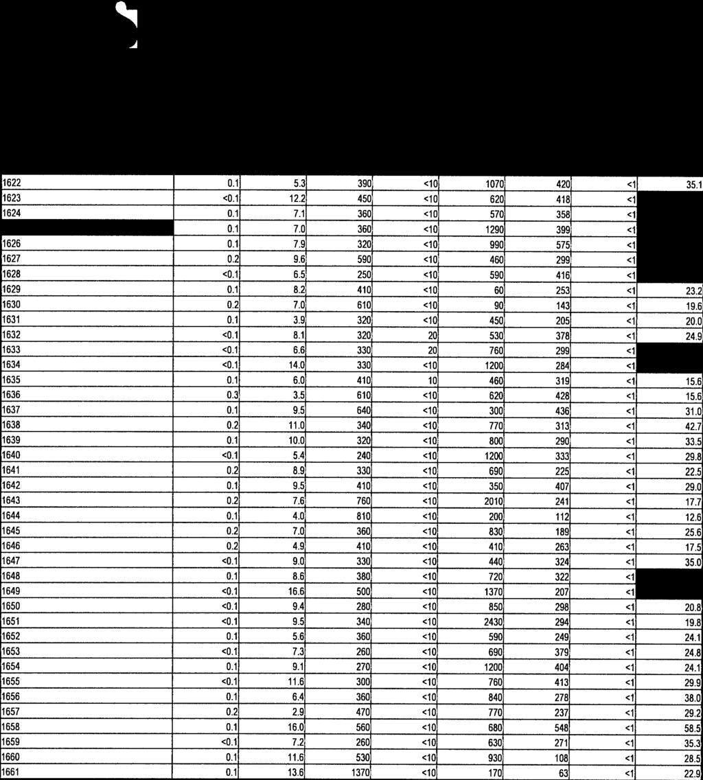
9 The following is an excerpt from the MMI Soil Sampling Guide, by SGS Labs, in regards to sampling in Boreal Climactic Zones: Scrape away any loose non-decomposed matter, debris, and any possible cultural contamination. Dig a small pit to penetrate the organic material that still has structure (i.e. decomposing leaves, bark, twigs and peat). Identify where the organics begin to decompose and you start to see soil formation. This is the true interface (organic / inorganic) at which to begin your measurements. Collect the sample between 10 and 25 cm below this interface. The sample should be a continuous composite taken from the 15 cm interval. Using a plastic scoop take a cross section of the material between the 10 to 25 cm depth and put into clean, properly labelled plastic bags. Collect approx. 250 to 350 grams of material. Samples were counted and logged by the author upon receipt, then placed into boxes for shipping to SGS Labs. Assay Method: Samples were sent to SGS Labs for Mobile Metal Ion detection assays using the MMI-M package to take advantage of the flexible multi-element assay (8) option with lower detection limits, at a reasonable cost. We will test for Gold(Au), Silver(Ag), Copper(Cu), Arsenic(As), Zinc(Zn), Lead(Pb), Platinum(Pd), and Potassium(K). MMI Theory: The theory given below was taken from the SGS Labs - Geochem Analysis 2012 Brochure: MMI Technology is an innovative analytical process that uses a unique approach to the analysis of metals in soils and weathered materials. Target elements are extracted using weak solutions of organic and inorganic compounds rather than conventional aggressive acid or cyanide- based digests. MMI solutions contain strong ligands, which detach and hold in solution the metal ions that were loosely bound to soil particles by weak atomic forces. The extraction does not dissolve the bound forms of the metal ions. Thus, the metal ions in the MMI solutions are the chemically active or mobile component of the sample. Because these mobile, loosely bound complexes are in very low concentrations,. Page 6

 Figure 6: MMI Theory.")
10 measurement is by conventional ICP-MS and the latest evolution of this technology, ICP-MS Dynamic Reaction Cell (DRC II ). (See Figure 6) Figure 6: MMI Theory. Page 7
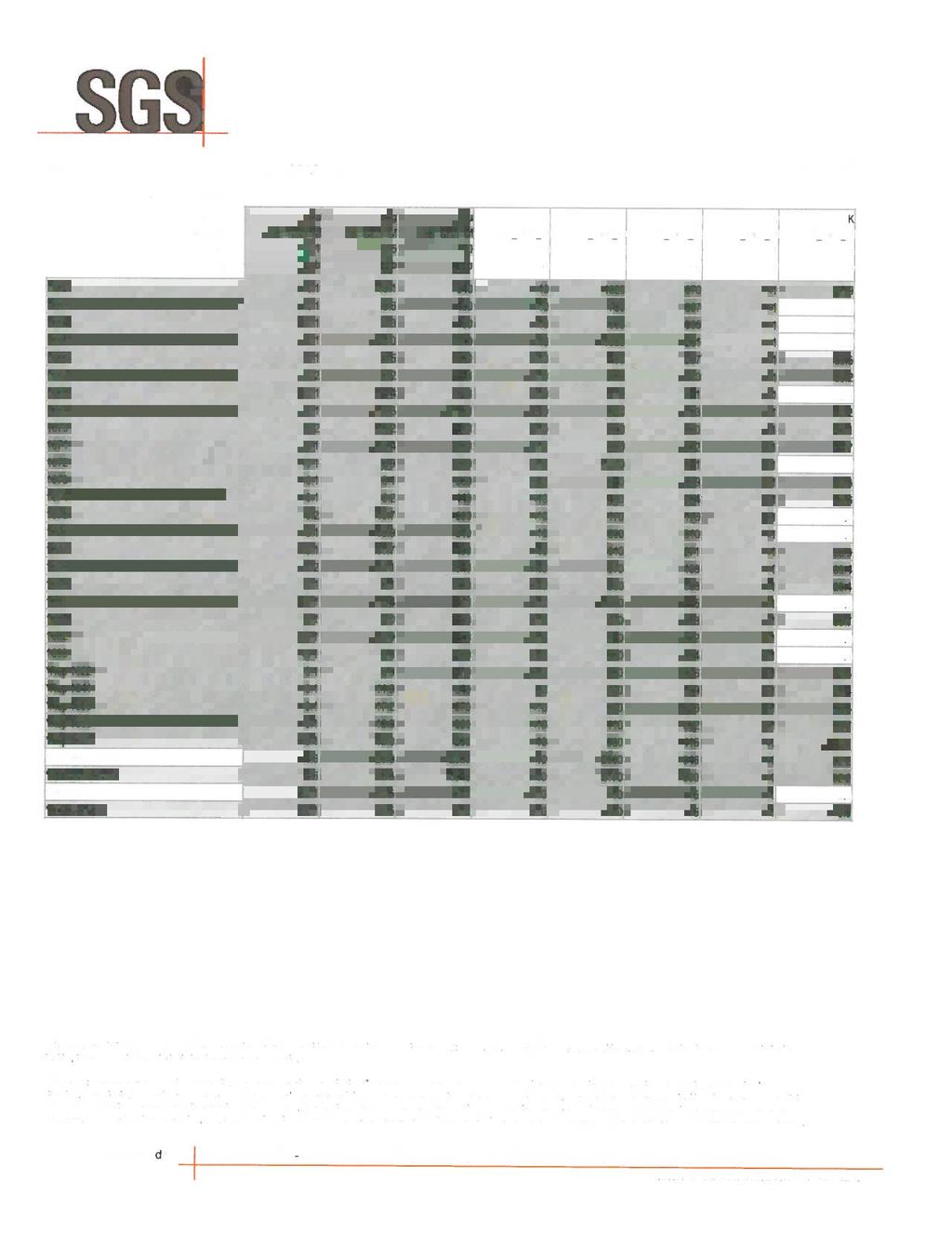
11 Results: Ag: All 62 samples reported well above the detection limit of 0.5ppb. The highest value of 21ppb is found at the south end of Line 2. The values above 15ppb are concentrated in the northeast quadrant of the claim block. (See Plan Map Ag.) As: All of the Arsenic values with the exception of 2 located at the north end of Line 5 are at or below the detection limit of 10ppb. The 2 values above the detection limit are 20 ppb. (See Plan Map As.) Au: Of the 62 samples collected and assayed for gold 37.8% are below the detection limit. The remaining values range from 0.1 to 0.2ppb. The highest assay of 0.3ppb is located along Line 5 at E/ N.(See Plan Map Au.) Cu: All 62 samples reported well above the detection limit of 10ppb. Elevated copper values are showing a correlation along strike that straddles the contact between the mafic and ultramafic units trending northeast-southwest through the central portion of the claim block. K: All 62 samples reported well above the detection limit of 0.5ppm. Elevated values in the 30 to 50ppm+ range seem concentrated in the northeast portion of the claim block. It is interesting to note that values in the 30 to 40ppm range show a correlation with the metasediment unit crossing through the south eastern part of the claim block. Pb: All 62 samples reported well above the detection limit of 5ppb. Of these 22.6% were above 400ppb and scattered across the entire claim showing no evident trends.. Page 8
12 Pb: All 62 samples were below the detection limit for palladium of 1ppb. Zn: All 62 samples reported well above the detection limit of 10ppb. Of the 62 samples 19.4% were above 1200ppb. These all appear to be confined to the mafic and ultramafic units crossing the claim. Conclusions and Recommendations: In conclusion the MMI Geochemical Survey has produced some interesting results. The effectiveness of the MMI Survey proved to be somewhat unclear. It would be prudent at this stage to augment the MMI Survey with some type of deep penetrating geophysical method as well as investigate further any known drill holes in the vicinity of the property.. Page 9
13 References: Satterly, J., Geology of Garrison Township, District of Cochrane, PR Ontario Department of Mine Satterly, J., O.G.S. Map No , Scale 1:20, Ayer, J.A., Berger, B.R. and Trowell, N.F., 1999, Geological compilation of the Lake Abitibi greenstone belt, O.G.S. Map P3398, Scale 1:100,000. Page 10
14 STATEMENT OF QUALIFICATIONS I, Brian Madill, of 142 Carter Ave. Kirkland Lake, Ontario, do hereby certify that: 1. I am a Prospector/Geological/Geophysical Technician and have been practicing my profession for the past 38 years. 2. I am a graduate of Cambrian College, Sudbury, Ontario having obtained a Geological Engineering Technician diploma in My knowledge of the property described herein was obtained by fieldwork and documentation. 4. I do not have or expect to receive any interest in the property that forms the basis of this report. 5. I am qualified to author this report. Respectfully, Brian H. Madill Brian H. Madill. Page 11
15 APPENDIX
16 Holloway North MMI Soil Sample Index Sheet Easting (Proposed) Northing (Proposed) Easting (Actual) Northing (Actual) Line # Sample Number Depth of Sample Sample (cm) Type of Soil Description of Soil Type Comments Clay Greyish brown to dark brown, fine grained, minor organics Clay Greyish brown to dark brown, fine grained, minor organics Clay Greyish brown to dark brown, fine grained, minor organics Clay Greyish brown to dark brown, fine grained, minor organics Clay Greyish brown to dark brown, fine grained, minor organics Clay Greyish brown to dark brown, fine grained, minor organics Clay Greyish brown to dark brown, fine grained, minor organics Clay Greyish brown to dark brown, fine grained, minor organics Clay Greyish brown to dark brown, fine grained, minor organics Easting (Proposed) Northing (Proposed) Easting (Actual) Northing (Actual) Line # Sample Number Depth of Sample Sample (cm) Type of Soil Description of Soil Type Comments Clay Greyish brown to dark brown, fine grained, minor organics Clay Greyish brown to dark brown, fine grained, minor organics Clay Greyish brown to dark brown, fine grained, minor organics Clay Greyish brown to dark brown, fine grained, minor organics Clay Greyish brown to dark brown, fine grained, minor organics Clay Greyish brown to dark brown, fine grained, minor organics Clay Greyish brown to dark brown, fine grained, minor organics Clay Greyish brown to dark brown, fine grained, minor organics Clay Greyish brown to dark brown, fine grained, minor organics
17 Holloway North MMI Soil Sample Index Sheet Easting (Proposed) Northing (Proposed) Easting (Actual) Northing (Actual) Line # Sample Number Depth of Sample Sample (cm) Type of Soil Description of Soil Type Comments Clay Greyish brown to dark brown, fine grained, minor organics Clay Greyish brown to dark brown, fine grained, minor organics Clay Greyish brown to dark brown, fine grained, minor organics Clay Greyish brown to dark brown, fine grained, minor organics Clay Greyish brown to dark brown, fine grained, minor organics Clay Greyish brown to dark brown, fine grained, minor organics Clay Greyish brown to dark brown, fine grained, minor organics Clay Greyish brown to dark brown, fine grained, minor organics Clay Greyish brown to dark brown, fine grained, minor organics Easting (Proposed) Northing (Proposed) Easting (Actual) Northing (Actual) Line # Sample Number Depth of Sample Sample (cm) Type of Soil Description of Soil Type Comments Clay Greyish brown to dark brown, fine grained, minor organics Clay Greyish brown to dark brown, fine grained, minor organics Clay Greyish brown to dark brown, fine grained, minor organics NO SAMPLE BEAVER POND Clay Greyish brown to dark brown, fine grained, minor organics Clay Greyish brown to dark brown, fine grained, minor organics Clay Greyish brown to dark brown, fine grained, minor organics Clay Greyish brown to dark brown, fine grained, minor organics Clay Greyish brown to dark brown, fine grained, minor organics
18 Holloway North MMI Soil Sample Index Sheet Easting (Proposed) Northing (Proposed) Easting (Actual) Northing (Actual) Line # Sample Number Depth of Sample Sample (cm) Type of Soil Description of Soil Type Comments Clay Greyish brown to dark brown, fine grained, minor organics Clay Greyish brown to dark brown, fine grained, minor organics Clay Greyish brown to dark brown, fine grained, minor organics Clay Greyish brown to dark brown, fine grained, minor organics Clay Greyish brown to dark brown, fine grained, minor organics ON BANK OF CREEK Clay Greyish brown to dark brown, fine grained, minor organics Clay Greyish brown to dark brown, fine grained, minor organics Clay Greyish brown to dark brown, fine grained, minor organics Clay Greyish brown to dark brown, fine grained, minor organics Easting (Proposed) Northing (Proposed) Easting (Actual) Northing (Actual) Line # Sample Number Depth of Sample Sample (cm) Type of Soil Description of Soil Type Comments Clay Greyish brown to dark brown, fine grained, minor organics Clay Greyish brown to dark brown, fine grained, minor organics Clay Greyish brown to dark brown, fine grained, minor organics Clay Greyish brown to dark brown, fine grained, minor organics ON BANK OF CREEK Clay Greyish brown to dark brown, fine grained, minor organics Clay Greyish brown to dark brown, fine grained, minor organics Clay Greyish brown to dark brown, fine grained, minor organics Clay Greyish brown to dark brown, fine grained, minor organics Clay Greyish brown to dark brown, fine grained, minor organics
19 Holloway North MMI Soil Sample Index Sheet Easting (Proposed) Northing (Proposed) Easting (Actual) Northing (Actual) Line # Sample Number Depth of Sample Sample (cm) Type of Soil Description of Soil Type Comments Clay Greyish brown to dark brown, fine grained, minor organics Clay Greyish brown to dark brown, fine grained, minor organics Clay Greyish brown to dark brown, fine grained, minor organics Clay Greyish brown to dark brown, fine grained, minor organics ADJACENT TO BEAVER DAM Clay Greyish brown to dark brown, fine grained, minor organics Clay Greyish brown to dark brown, fine grained, minor organics Clay Greyish brown to dark brown, fine grained, minor organics Clay Greyish brown to dark brown, fine grained, minor organics Clay Greyish brown to dark brown, fine grained, minor organics


20

21
22
23 SOIL SAMPLE PLAN MAPS
24
25
26
27
28
29
30
31
We are committed to providing accessible customer service. If you need accessible formats or communications supports, please contact us.
 We are committed to providing accessible customer service. If you need accessible formats or communications supports, please contact us. Nous tenons à améliorer l accessibilité des services à la clientèle.
SUMMARY REPORT. RE-ESTABLISH CLAIM BOUNDARY (Claim ) CARR TOWNSHIP (Larder Lake Mining Division) NTS (42 Al09) FOR
 CARR TOWNSHIP (Larder Lake Mining Division) NTS (42 Al09) FOR") 2.44330 " SUMMARY REPORT RE-ESTABLISH CLAIM BOUNDARY (Claim 3002288) CARR TOWNSHIP (Larder Lake Mining Division) NTS (42 Al09) FOR ST ANDREW GOLDFIELDS LTD. ""'1,.I Les 1. Kovacs, P. Geo For: St Andrew
2.44330 " SUMMARY REPORT RE-ESTABLISH CLAIM BOUNDARY (Claim 3002288) CARR TOWNSHIP (Larder Lake Mining Division) NTS (42 Al09) FOR ST ANDREW GOLDFIELDS LTD. ""'1,.I Les 1. Kovacs, P. Geo For: St Andrew
We are committed to providing accessible customer service. If you need accessible formats or communications supports, please contact us.
 We are committed to providing accessible customer service. If you need accessible formats or communications supports, please contact us. Nous tenons à améliorer l accessibilité des services à la clientèle.
REPORT ON DIAMOND DRILLING SUBSTITUTION EAST PROPERTY CLAIMS AND HEBERT TOWNSHIP ONTARIO, CANADA
 REPORT ON DIAMOND DRILLING SUBSTITUTION EAST PROPERTY CLAIMS 1248920 AND 1248921 HEBERT TOWNSHIP ONTARIO, CANADA Adroit Resources Inc. Suite #610-1111 Melville Street Vancouver, British Columbia, Canada
Total Magnetic Field and VLF Surveys on the Swayze Property. Claim Swayze Township. Porcupine Mining Division
 1 January, 016 NTS: 041 O 15 Total Magnetic Field and VLF Surveys on the Swayze Property Claim 475471 Swayze Township Porcupine Mining Division 380850E, 599450N UTM Z17N NAD83 Report Prepared for: 540
EXPLOR INTERSECTS MULTIPLE COPPER ZONES GRADES UP TO 3.65% CU OVER 5.35 METERS ON THE CHESTER COPPER PROPERTY
 15 Gamble East Street - Suite 204 - Rouyn-Noranda (Canada) J9X 3B6 Listing (TSX-V = EXS) (OTCQB = EXSFF) (FSE & BE = E1H1) EXPLOR INTERSECTS MULTIPLE COPPER ZONES GRADES UP TO 3.65% CU OVER 5.35 METERS
We are committed to providing accessible customer service. If you need accessible formats or communications supports, please contact us.
 We are committed to providing accessible customer service. If you need accessible formats or communications supports, please contact us. Nous tenons à améliorer l accessibilité des services à la clientèle.
We are committed to providing accessible customer service. If you need accessible formats or communications supports, please contact us.
 We are committed to providing accessible customer service f you need accessible formats or communications supports please contact us Nous tenons à améliorer l accessibilité des services à la clientèle
Report of Gridding and Magnetic Surveys. On the. Munro Property. Munro and Beatty Townships, Ontario. Larder Lake Mining Division
 Report of Gridding and Magnetic Surveys On the Munro Property Munro and Beatty Townships, Ontario Larder Lake Mining Division Claims: 39 4244 For Big Red Diamond Corporation October 3, 2 Timmins, Ontario
Detour West Gold Project Technical Overview. April, 2018
 Detour West Gold Project Technical Overview April, 2018 Detour West Project Overview Detour West is a 7,680 hectare property located at the northwest margin of the Abitibi Greenstone Belt, 20 km west of
We are committed to providing accessible customer service. If you need accessible formats or communications supports, please contact us.
 We are committed to providing accessible customer service. If you need accessible formats or communications supports, please contact us. Nous tenons à améliorer l accessibilité des services à la clientèle.
WORK REPORT. on the ALEXO PROPERTY DUNDONALD TOWNSHIP PORCUPINE MINING DIVISION. for LIBERTY MINES INC.
 GEOSCIE CE AS r::;ss lent OFFICE WORK REPORT on the ALEXO PROPERTY DUNDONALD TOWNSHIP PORCUPINE MINING DIVISION for LIBERTY MINES INC. 2. 340 51 Submitted by: Steve Anderson VISION EXPLORATION 2041663
TECHNICAL REPORT ON THE BLACK CREEK PROPERTY FOR CARRIE ARRAN RESOURCES BLACK TOWNSHIP LARDER LAKE MINING DIVISION ONTARIO
 TECHNICAL REPORT ON THE BLACK CREEK PROPERTY FOR CARRIE ARRAN RESOURCES BLACK TOWNSHIP LARDER LAKE MINING DIVISION ONTARIO B.J. McKay, 8 February 2011 Keewatin, Ontario TECHNICAL REPORT BJML 2011 Table
National Instrument Technical Report
 National Instrument 43-101Technical Report Pigeon River Property Hartington Township Ontario, Canada Thunder Bay Mining Division, NTS 42A4 Geology Updated Technical Report UTM: Zone 16, 277134m E, 5332229m
We are committed to providing accessible customer service. If you need accessible formats or communications supports, please contact us.
 We are committed to providing accessible customer service. If you need accessible formats or communications supports, please contact us. Nous tenons à améliorer l accessibilité des services à la clientèle.
ASSESSMENT REPORT ON THE PEAVINE PROJECT. DGW & Associates # Alberni Street, Vancouver, British Columbia, V6E 4V2
 ASSESSMENT REPORT ON THE PEAVINE PROJECT KAMLOOPS MINING DIVISION BRITISH COLUMBIA NTS 082M 12 Latitude 51 36' 19.0"North -- Longitude --119 47' 27.0"West UTM Zone 11, NAD 83 5720827N 306744E Prepared
July Exploring for Canadian Gold in the Rainy River District of Ontario
 July 2013 Exploring for Canadian Gold in the Rainy River District of Ontario 1 Forward Looking Statements Some of the statements in this document may be deemed to be "forward-looking statements". All statements
COMBINATION OF MMI AND ENZYME LEACH METHODS IN EXPLORATION FOR GOLD IN AN AREA OF THE CANADIAN SHIELD COVERED WITH GLACIAL SEDIMENTS: A CASE STUDY
 COMBINATION OF MMI AND ENZYME LEACH METHODS IN EXPLORATION FOR GOLD IN AN AREA OF THE CANADIAN SHIELD COVERED WITH GLACIAL SEDIMENTS: A CASE STUDY Nadia Yavorskaya 450 Bonner Ave., Winnipeg, MB, Canada
We are committed to providing accessible customer service. If you need accessible formats or communications supports, please contact us.
 We are committed to providing accessible customer service. If you need accessible formats or communications supports, please contact us. Nous tenons à améliorer l accessibilité des services à la clientèle.
TIGER GOLD EXPLORATION CORPORATION. Prospecting Over the HARKER HERITAGE PROPERTY AREA 10. Harker Township, Ontario
 PO Box 219, 14579 Government Road, Larder Lake, Ontario, P0K 1L0, Canada Phone (705) 643-2345 Fax (705) 643-2191 www.cxsltd.com TIGER GOLD EXPLORATION CORPORATION Prospecting Over the HARKER HERITAGE PROPERTY
Sherlock drilling returns best intercept to date of 0.63% Cu and 7.45 g/t Ag over m
 NEWS RELEASE For immediate distribution Sherlock drilling returns best intercept to date of 0.63% Cu and 7.45 g/t Ag over 34.25 m All the five drill holes successfully intersected the mineralized stratigraphy
We are committed to providing accessible customer service. If you need accessible formats or communications supports, please contact us.
 We are committed to providing accessible customer service. If you need accessible formats or communications supports, please contact us. Nous tenons à améliorer l accessibilité des services à la clientèle.
Toronto, Canada March 4, 2013
 NEWS RELEASE SAS REPORTS ADDITIONAL DRILLING RESULTS FOR THE HISLOP NORTH AND SMOKE DEEP ZONES AND SIGNIFICANT INITIAL RESULTS FROM THE HISLOP PIT COMPLEX AND NEW SEDIMENT ZONE AT THE HOLLOWAY MINE Hislop
April Exploring for Canadian Gold in the Rainy River District of Ontario
 April 2013 Exploring for Canadian Gold in the Rainy River District of Ontario 1 Forward Looking Statements This presentation may contain forward-looking statements including but not limited to comments
We are committed to providing accessible customer service. If you need accessible formats or communications supports, please contact us.
 We are committed to providing accessible customer service. If you need accessible formats or communications supports, please contact us. Nous tenons à améliorer l accessibilité des services à la clientèle.
Report on Prospecting on Claims & in the Federal Mine Property Teck Township Larder Lake Mining Division.
 1 Report on Prospecting on Claims 1227076 & 1222223 in the Federal Mine Property Teck Township Larder Lake Mining Division July 19, 2015 2 Table of Contents Introduction... 3 Summary... 3 Property Descriptions
We are committed to providing accessible customer service. If you need accessible formats or communications supports, please contact us.
 We are committed to providing accessible customer service. If you need accessible formats or communications supports, please contact us. Nous tenons à améliorer l accessibilité des services à la clientèle.
Project 81. Drill Ready Geophysical Targets & Trends. Timmins-Cochrane Northern Ontario Canada
 Project 81 Drill Ready Geophysical Targets & Trends Timmins-Cochrane Northern Ontario Canada FORWARD-LOOKING STATEMENT Certain statements contained in this presentation that are forwardlooking in nature
Mishi Lake Gold Property Mishibishu Lake Area, Wawa
 Mishi Lake Gold Property Mishibishu Lake Area, Wawa Location, Accessibility, Infrastructure and Local Resources The property is located 40 km west of Wawa, Ontario, in the Mishibishu Lake Area, Sault Ste.
NEWS RELEASE CANADIAN ZINC REPORTS REMAINING DRILL RESULTS AT LEMARCHANT DEPOSIT, SOUTH TALLY POND PROJECT, NEWFOUNDLAND
 NEWS RELEASE CZN-TSX CZICF-OTCQB FOR IMMEDIATE RELEASE March 5, 2018 CANADIAN ZINC REPORTS REMAINING DRILL RESULTS AT LEMARCHANT DEPOSIT, SOUTH TALLY POND PROJECT, NEWFOUNDLAND 2017 drill program successfully
ANTLER GOLD HIGHLIGHTS NEW GOLD-IN-SOIL ANOMALIES, CENTRAL NEWFOUNDLAND
 ANTLER GOLD HIGHLIGHTS NEW GOLD-IN-SOIL ANOMALIES, CENTRAL NEWFOUNDLAND HALIFAX, NOVA SCOTIA (CNW October 17, 2018) Antler Gold Inc. ( Antler ) (TSX- V:ANTL) is pleased to provide an update on its successful
Prospecting Report 'S Office i DB Property, B.C. -J Negro Creek Nelson Mining District NTS 82F.050. Operator: Kootenay Gold Inc.
 . '.' I"' i9 12 Prospecting Report 'S Office i DB Property, B.C. -J Negro Creek Nelson Mining District NTS 82F.050 Operator: Kootenay Gold Inc. Owner: Darlene Lavoie Work Performed Summer of 2007 Report
KIRKLAND LAKE GOLD INTERSECTS NEW MINERALIZATION AT TAYLOR MINE, CONTINUES TO EXTEND PORPHYRY DEPOSITS TO DEPTH
 KIRKLAND LAKE GOLD INTERSECTS NEW MINERALIZATION AT TAYLOR MINE, CONTINUES TO EXTEND PORPHYRY DEPOSITS TO DEPTH Drilling identifies gold-bearing quartz veins at multiple locations up to 1.8 km east of
DÉCOUVERTE Positioned for Discovery in James Bay, Quebec. Investor Presentation, January 2018 by Danae Voormeij, MSc, PGeo
 DÉCOUVERTE Positioned for Discovery in James Bay, Quebec Investor Presentation, January 2018 by Danae Voormeij, MSc, PGeo Location Maps and Infrastructure Location: Durango Resources 100% owned Découverte
Mineral Resource Estimate Comparison at 3 g/t Au cut-off
 HARTE GOLD CORP. 8 King Street East, Suite 1700 Toronto, Ontario, M5C 1B5 Tel: 416-368-0999 Fax: 416-368-5146 Harte Gold Announces 2018 Drilling Increases Indicated Mineral Resources by 55% Overall Resource
TIGER GOLD EXPLORATION CORPORATION. Prospecting Over the HARKER HERITAGE PROPERTY AREA 1. Clifford Township, Ontario
 PO Box 219, 14579 Government Road, Larder Lake, Ontario, P0K 1L0, Canada Phone (705) 643-2345 Fax (705) 643-2191 www.cxsltd.com TIGER GOLD EXPLORATION CORPORATION Prospecting Over the HARKER HERITAGE PROPERTY
NTS 93L/9W GEOCHEMICAL AND GEOPHYSICAL REPORT MONA CLAIM OMINICA MINING DIVISION. Lati tude 54036'N; Longitude 'W
 GEOCHEMICAL AND GEOPHYSICAL REPORT ON MONA CLAIM OMINICA MINING DIVISION Lati tude 54036'N; Longitude 126018'W NTS 93L/9W April 1981 Paul Plicka Consulting Geologist LOCATION MAP INTRODUCTION TABLE OF
DiaMine Exploration Inc. Pickle Lake Option Property
 DiaMine Exploration Inc. Pickle Lake Option Property Rock Sampling Program and Field Observations Claims 4249174, 4249175, 4249176 and 4249177, Kapkichi Lake Area (G-2081) And Claims 4249178, 4249179 and
KIRKLAND LAKE GOLD EXPANDS NEW HIGH-GRADE ZONE BELOW TAYLOR MINE, REPORTS MINERALIZED EXTENSIONS ALONG STRIKE AND AT DEPTH
 KIRKLAND LAKE GOLD EXPANDS NEW HIGH-GRADE ZONE BELOW TAYLOR MINE, REPORTS MINERALIZED EXTENSIONS ALONG STRIKE AND AT DEPTH New gold zone intersected 500 metres ( m ) below existing mining and mine infrastructure
INTRODUCTION REGIONAL GEOLOGY. N. St-Jean 1, L. Hunt 1 and R.L. Sherlock 1
 37. Preliminary Results from Mapping a New Exposure of the Basal Unconformity Between the Hearst and Larder Lake Assemblages, Skead Township, Northeastern Ontario N. St-Jean 1, L. Hunt 1 and R.L. Sherlock
RECEIVED. tn r-"t."' Magnetometer and VLF-EM Surveys Assessment Report. South Cobalt Silver Project South Lorrain Twp. Mhakari Gold Corp.
 RECEVED APR 1 5 111 OOSC!C! AESSMET tn r-"t. Magnetometer and VLF-EM Surveys Assessment Report South Cobalt Silver Project South Lorrain Twp. Mhakari Gold Corp. March 211 TS 31 M/3-4 Meegwich Consultants
ENCOURAGING GOLD-BASE METALS AT MAY DAY, MOLY- GOLD AT ATTUNGA
 ASX / MEDIA RELEASE 5 JULY 2010 ENCOURAGING GOLD-BASE METALS AT MAY DAY, MOLY- GOLD AT ATTUNGA Peel Exploration is pleased to announce that recent drilling at the Company s Attunga and May Day projects
Magnetic Field and VLF Surveys on the Shining Tree Property. Claims: , , , , , , , ,
 December 29, 2014 NTS: 041P11 Magnetic Field and VLF Surveys on the Shining Tree Property Claims: 1203361, 4251801, 4251803, 4251805, 4263067, 4263068, 4270940, 4270436, 4276740 Churchill and Asquith Townships
1 FILMED 1. FILE NO:!..rsrru -* -. GRAND TWO CLAIM
 FILE NO:!..rsrru -* -. GRAND TWO CLAIM REPORT ON 1993 ASSESSMENT WORK GRAND TWO CLAIM REC. NO. 301849 NELSON MINING DIVISION NTS MAP SHEET 82F6/W 49 25'51" NORTH 117 18'08" WEST 1 FILMED 1 AUTHOR: R. Jordan,
Serengeti Resources Inc GEOCHEMICAL REPORT ON THE SHADOW PROPERTY a.
 Serengeti Resources Inc. 2004 GEOCHEMICAL REPORT ON THE SHADOW PROPERTY a. Located in the Johanson Lake Area Omenica Mining Division NTS 94D/9 6 degrees and 32 minutes North Latitude 126 degrees and 2
Burchell Lake, A Copper, Gold and Molybdenum Property In Ontario. Corporate Presentation September, 2013
 Burchell Lake, A Copper, Gold and Molybdenum Property In Ontario Corporate Presentation September, 2013 Background Tanager Energy Inc. is a Canadian corporation whose shares are traded on the TSX Venture
Assessment Report on Diamond Drilling and. Application for Bulk Sampling. Mortimer Soapstone Project. Garnet Township NTS 41 OINE
 2. 9276 Assessment Report on Diamond Drilling and Application for Bulk Sampling Mortimer Soapstone Project Garnet Township NTS 41 OINE September 17, 2008 Todd Keast P.Geo. , INTRODUCTION In February 2007
The Cobalt Rainbow. Airborne geophysical maps show that a north trending aeromagnetic high suggests further undiscovered mineralisation.
 The Cobalt Rainbow The property is located on Greenstone Creek, approximately 4.8 kilometres south west of the creek mouth. The property is located about 24 km due west of Campbell River, in the east-central
2014 AEROQUEST AIRBORNE HELI-BORNE VTEM PLUS AND HORIZONTAL MAGNETIC GRADIOMETER SURVEY ASSESSMENT REPORT CAMERON GOLD PROJECT
 2014 AEROQUEST AIRBORNE HELI-BORNE VTEM PLUS AND HORIZONTAL MAGNETIC GRADIOMETER SURVEY ASSESSMENT REPORT CAMERON GOLD PROJECT PREPARED BY: Nick Walker. January 2015 SUMMARY This report presents the results
PIOTR LUTYNSKI VANCOUVER, BRITISH COLUMBIA
 AN ASSESSMENT REPORT ON GROUND MAGNETIC SURVEYING CHUCHI PROPERTY FORT ST. JAMES AREA, BRITISH COLUMBIA OMINECA M.D. 55 17 N, 124 31 W NTS 93N/ 7&8 Claims Surveyed: 597976, 597878-597880 Survey Dates:
Magmatic-Hydrothermal Gold Systems in the Archean of Northern Ontario, Canada: Examples of Syenite-Associated and Porphyry-Type Au-(Cu) Deposits
 Deposits") Magmatic-Hydrothermal Gold Systems in the Archean of Northern Ontario, Canada: Examples of Syenite-Associated and Porphyry-Type Au-(Cu) Deposits By Dr. Daniel J. Kontak Department of Earth Sciences Laurentian
Magmatic-Hydrothermal Gold Systems in the Archean of Northern Ontario, Canada: Examples of Syenite-Associated and Porphyry-Type Au-(Cu) Deposits By Dr. Daniel J. Kontak Department of Earth Sciences Laurentian
A B C PAD A HIGHLIGHTS
 Murchison Minerals Intercepts 12.30% Zinc, 0.70% Copper, 0.18% Lead and 42.03 g/t Silver 14.97% ZnEq over 6.37 Metres and Extends Known Limits of Brabant McKenzie VMS Deposit June 25, 2018 (Toronto, Ontario):
GEOLOGICAL BRANCH ASSESSMENT REPORT 12. FItE NO: ACTION: THE GOLDEN MINING DIVISION, GOLDEN, Including THE NTS MAP; M82K/15W
 ACTION: FItE NO: Including 1990 GEO-CHEM SURVEY RESULTS -- THE AVD CLAIMS - THE GOLDEN MINING DIVISION, GOLDEN, B.C. NTS MAP; M82K/15W Lat. 50 deg. 55 Min. Long 116 deg. 55 min. For GEOLOGICAL BRANCH ASSESSMENT
r ffj Ronald C. Wells, BSc. Lacana Mining Corporation LACANA CLAIMS GAUTMER TOWNSMP GEOPHYSICAL REPORT OCT LARDER LAKE MINING DIVISION
 a- 32D04NWei39 2.3507 GAUTHIER 010 GEOPHYSICAL REPORT LACANA CLAIMS GAUTMER TOWNSMP LARDER LAKE MINING DIVISION RECEIVED OCT171980 MINING UNDS SECTION Author: Ronald C. Wells, BSc. Lacana Mining Corporation
Mineral Exploration Report on the Work carried out on Claims Kuohunsuo 2-3 and Sipsanaho 1, Kiannanniemi Area, Suomussalmi
 1 (5) Distribution: Ministry of Trade and Industry 2 copies Polar Mining Oy, Outokumpu 1 copy Mineral Exploration Report on the Work carried out on Claims Kuohunsuo 2-3 and Sipsanaho 1, Kiannanniemi Area,
FOCUSED ON ACQUIRING, EXPLORING AND ADVANCING QUALITY MINING PROJECTS IN THE AMERICAS CORPORATE PRESENTATION 1
 FOCUSED ON ACQUIRING, EXPLORING AND ADVANCING QUALITY MINING PROJECTS IN THE AMERICAS JUNE 2018 CORPORATE PRESENTATION 1 Disclaimer Except for the statements of historical fact contained herein, certain
NEW COBAR-STYLE COPPER DISCOVERY IN NSW
 ASX / MEDIA RELEASE 2 AUGUST 2011 NEW COBAR-STYLE COPPER DISCOVERY IN NSW Broad zone of copper-polymetallic mineralisation intersected at 4-Mile prospect Highlights: Wide zone of copper-silver-gold-lead-zinc
1 CLAIMS GEOPHYSICAL REPORT ON BOYAL SITUATE NORTHEAST OF TILLICUM MOUNTAIN GOLD AREA BURTON - NAKUSP SIQCAEJ MINING DIVISION
 GEOPHYSICAL REPORT ON BOYAL 1 CLAIMS SITUATE NORTHEAST OF TILLICUM MOUNTAIN GOLD AREA BURTON - NAKUSP SIQCAEJ MINING DIVISION CONSULTING GEOLOGIST AUGUST 1983 VANCOUVER B *C INDEX INTRODUCTION ooa,.eoaaa.aaaoaaooaoa~ao~o
ASX Announcement. FLEM survey underway at Henrietta Cobalt Nickel Prospect, Tasmania ASX: AX8 HIGHLIGHTS. Market Data. Board and Management.
 FLEM survey underway at Henrietta Cobalt Nickel Prospect, Tasmania ASX Announcement Market Data ASX Code: AX8 Shares on Issue: 47,620,000 Board and Management Grant Mooney Non-Executive Chairman Andrew
Queenston intersects Contact Zone on the Pandora Property and new gold zones in Kirkland Lake
 1 Queenston intersects Contact Zone on the Pandora Property and new gold zones in Kirkland Lake TORONTO, Ontario, March 7, 2003. Queenston Mining Inc. (QMI-TSX) reports diamond drill results on its 100%
Special Situation - March 2006
 Goldletter I N T E R N A T I O N A L the international independent information and advice bulletin for gold and related investments Special Situation - March 2006 Moneta Porcupine Mines (Cdn$ 0.16) TSX
UNION MINIERE EXPLORATIONS AND MINING CORPORATION LIMITED ASSESSMENT REPORT ON FITINAT MINERAL CLAIM. Alberni Mining Division Record No.
 M F )( UNION MINIERE EXPLORATIONS AND MINING CORPORATION LIMITED Suite 200, 4299 Canada Way, Burnaby, B.C. V5G 1 H4 Telephone (604) 437-9491 ASSESSMENT REPORT ON GEOCHEMICAL SOIL SURVEYS AND ROCKSAMPLING
for the Greenwood Mining Division, B.C. NTS 82E/7W Latitude 49' 27' W, Longitude 118' 5 Prepared by a= D. Dylan Watt, B.Sc.
 t. b LOGnO: 37~ -08 m. ACTIO#: for the AMP AMP 2 AMP 3 t AMP 4 CLAIMS Greenwood Mining Division, B.C. NTS 82E/7W Latitude 49' 27' W, Longitude 8' 5 %E c,w zc *& a w Prepared by a= -4c. D. Dylan Watt, B.Sc.
State Metallic Minerals Lease Sale Minnesota s Vermilion Gold District
 State Metallic Minerals Lease Sale Minnesota s Vermilion Gold District State Metallic Minerals Lease Sale Notice of Intent Scale 1:100,000 State Metallic Minerals Lease Sale This portion of the lease sale
%+ '$# $) %, %*$ " $ $ ' %' !()'-!" %( %"%! " *'+ - % %$! $)! " $)!" !$ ' "! )( ! $ '%& ')- % % "!#( (( ((# $) ' ) ((* & *# ' % %"*# ( !!
 %, %*$ $ $ ' %' !()'-! %( %%! *'+ - % %$! $)! $)! !$ ' ! )( ! $ '%& ')- % % !#( (( ((# $) ' ) ((* & *# ' % %*# ( !!") 001L/14/0218 First Year Assessment Report of Prospecting, Rock and Stream Sediment Sampling On Licence 18880M, NTS 1L/14 Burin Peninsula Newfoundland and Labrador Submitted by: Keith Kelloway Work year:
001L/14/0218 First Year Assessment Report of Prospecting, Rock and Stream Sediment Sampling On Licence 18880M, NTS 1L/14 Burin Peninsula Newfoundland and Labrador Submitted by: Keith Kelloway Work year:
Introducti on. Land Survey. Geomagnetic Survey. Geomagnetic Results and Interpretati ons - Conclusions and Recommendations C
 m M 42A86SW8281 63.42 PRICE 010 C O H T E H l 42A86SW828I 63.42 PRICE 010C Introducti on Land Survey Geomagnetic Survey Geomagnetic Results and Interpretati ons - Conclusions and Recommendations - - -
McVicar Lake Gold Property Lang Lake Greenstone Belt Ontario. Argo Gold Inc. (ARQ)
") McVicar Lake Gold Property Lang Lake Greenstone Belt Ontario Argo Gold Inc. (ARQ) Forward Looking Statements This presentation may contain forward-looking statements that involve a number of risks and
McVicar Lake Gold Property Lang Lake Greenstone Belt Ontario Argo Gold Inc. (ARQ) Forward Looking Statements This presentation may contain forward-looking statements that involve a number of risks and
La Peltrie Gold Project Lower Detour Trend Abitibi, Quebec
 Sept. 2017 La Peltrie Gold Project Lower Detour Trend Abitibi, Quebec In partnership with NioBay Metals Inc. Ontario Quebec LA PELTRIE - LOCATION Detour Lake Mine Reserves 14.4 Moz Au Manthet Project Casault
Melkior retains Geologica to complete a NI report on its Launay property, Québec
 TSX.V: MKR / OTCPK: MKRIF / FSE: MEK September 4 th, 2014 Melkior retains Geologica to complete a NI 43-101 report on its Launay property, Québec Ottawa, Ontario. Melkior Resources Inc. ( Melkior or the
RECONNAISSANCE AND SOIL GEOCHEMICAL SAMPLING REPORT PORCUPINE MINING DIVISION ON CLAIM , LANGMUIR TOWNSHIP
 RECONNAISSANCE AND SOIL GEOCHEMICAL SAMPLING REPORT ON CLAIM 1224499, LANGMUIR TOWNSHIP PORCUPINE MINING DIVISION CLM 1224499 NTS: 42A/06 Author: William Randall, P.Geo 1 Table of Contents Work Performed
SEDEX MINING CORPORATION LTD.
 P.O. Box 219, 14579 Government Road, Larder Lake, Ontario, Canada, P0K 1L0 Telephone: +1 705.643.2345 Facsimile: +1 705.643.2191 Email: katrine@larder.ca www.explorationservices.ca SEDEX MINING CORPORATION
ASX / MEDIA RELEASE 6 MAY MILE SILVER-LEAD-ZINC DISCOVERY; HIGH GRADE SILVER-GOLD IN ROCK CHIPS AT RUBY SILVER
 ASX / MEDIA RELEASE 6 MAY 2011 4-MILE SILVER-LEAD-ZINC DISCOVERY; HIGH GRADE SILVER-GOLD IN ROCK CHIPS AT RUBY SILVER Highlights: Silver-lead-zinc discovery at 4-Mile; mineralisation intersected in all
We are committed to providing accessible customer service. If you need accessible formats or communications supports, please contact us.
 We are committed to providing accessible customer service. If you need accessible formats or communications supports, please contact us. Nous tenons à améliorer l accessibilité des services à la clientèle.
WORK REPORT on the ALEXO PROPERTY DUNDONALD TOWNSHIP PORCUPINE MINING DIVISION for LIBERTY MINERAL EXPLORATION
 WORK REPORT on the ALEXO PROPERTY DUNDONALD TOWNSHIP PORCUPINE MINING DIVISION for LIBERTY MINERAL EXPLORATION Submitted by: Steve Anderson VISION EXPLORATION 170 Second Ave Timmins, Ontario P4N-IGI Phone:
4. Geological maps published by the Ontario Department of Mines.
 52J08NWei45 S2J08NWa6B1 SMYE 010 AMALGAMATED RARE EARTH MINES LTD. *, SAVANT LAKE PROSPECT x ONTARIO INTRODUCTION t This Is a report on a group of 28 claims control led by Amalgamated Rare Earth Mines
BALFOUR MINING LTD. (N.P.L.) HAM GROUP 92-P-6, CLINTON M. D.8 B. C. Lat 51 17'N, GEOCHEMICAL REPORT. V. CUKOR, P. Eng.
 HAM GROUP 92-P-6, CLINTON M. D.8 B. C. Lat 51 17'N, GEOCHEMICAL REPORT. V. CUKOR, P. Eng.") 34q '7 BALFOUR MINING LTD. (N.P.L.) HAM GROUP 92-P-6, CLINTON M. D.8 B. C. Lat 51 17'N, Long 12lo14'W GEOCHEMICAL REPORT, V. CUKOR, P. Eng. January 31, 1972 TABLE OF CONTENTS 1. INTRODUCTION 2. PROPERTY,
34q '7 BALFOUR MINING LTD. (N.P.L.) HAM GROUP 92-P-6, CLINTON M. D.8 B. C. Lat 51 17'N, Long 12lo14'W GEOCHEMICAL REPORT, V. CUKOR, P. Eng. January 31, 1972 TABLE OF CONTENTS 1. INTRODUCTION 2. PROPERTY,
PROSPECTORS ASSISTANCE PROGRAM MINISTRY OF ENERGY AND MINES
 BRITISH COLUMBIA PROSPECTORS ASSISTANCE PROGRAM MINISTRY OF ENERGY AND MINES GEOLOGICAL SURVEY BRANCH PROGRAM YEAR: 1999/2000 REPORT #: PAP 99-l 6 NAME: KIM ANSCHETZ PROSPECTORS TlEPORT on the 99 LOUIS
CHAMPION BEAR RESOURCES
 CHAMPION BEAR RESOURCES EXPLORING ADVANCED STAGE PRECIOUS METAL PROPERTIES IN ONTARIO Exploration Update January 2011 Forward Looking Statements This exploration update contains forward looking statements
SUMMARY REPORT. ESSAR STEEL ALGOMA INC. 105 West Street, Sault Ste. Marie, Ontario, Canada P6A 7B4
 SUMMARY REPORT IRON LAKE PROPERTY Keating and Keating Additional Townships, Ontario, Canada ESSAR STEEL ALGOMA INC. 105 West Street, Sault Ste. Marie, Ontario, Canada P6A 7B4 Date: March 18, 2013 Prepared
IAMGOLD ANNOUNCES RESULTS FROM THE WESTWOOD-MOOSHLA EXPLORATION PROJECT
 No. 01/07 IAMGOLD ANNOUNCES RESULTS FROM THE WESTWOOD-MOOSHLA EXPLORATION PROJECT Toronto, Ontario, January 17, 2007 IAMGOLD Corporation ( IAMGOLD or the Company ) is pleased to announce results of 10
MONETA INTERCEPTS g/t GOLD INCLUDING g/t GOLD AND g/t GOLD INCLUDING g/t GOLD AT SOUTH WEST
 NEWS RELEASE 15/2018 Symbol: TSX: ME FOR IMMEDIATE RELEASE MONETA INTERCEPTS 5.30 m @ 7.63 g/t GOLD INCLUDING 0.80 m @ 22.40 g/t GOLD AND 7.13 m @ 5.06 g/t GOLD INCLUDING 1.98 m @ 12.47 g/t GOLD AT SOUTH
BALTO RESOURCES LTD. (Owner & Operator) GEOPHYSICAL ASSESSMENT REPORT. (Event Number ) on the SED MINERAL CLAIM.
 GEOPHYSICAL ASSESSMENT REPORT. (Event Number ) on the SED MINERAL CLAIM.") BALTO RESOURCES LTD. (Owner & Operator) GEOPHYSICAL ASSESSMENT REPORT (Event Number 5173274) on the SED MINERAL CLAIM (Tenure 392163) Kamloops Mining Division NTS 092I.047 Centre of Work 5589550N, 667600E
BALTO RESOURCES LTD. (Owner & Operator) GEOPHYSICAL ASSESSMENT REPORT (Event Number 5173274) on the SED MINERAL CLAIM (Tenure 392163) Kamloops Mining Division NTS 092I.047 Centre of Work 5589550N, 667600E
We are committed to providing accessible customer service. If you need accessible formats or communications supports, please contact us.
 We are committed to providing accessible customer service. If you need accessible formats or communications supports, please contact us. Nous tenons à améliorer l accessibilité des services à la clientèle.
Advancing High Grade Gold Assets in Red Lake, Ontario
 Advancing High Grade Gold Assets in Red Lake, Ontario Forward Looking Statement Except for historical information contained herein, this presentation may contain forward-looking statements including but
COMPASS GOLD: FIELDWORK CONTINUES ON OUASSADA & SANKARANI PERMITS TO AID BEDROCK DRILLING TARGETING
 COMPASS GOLD: FIELDWORK CONTINUES ON OUASSADA & SANKARANI PERMITS TO AID BEDROCK DRILLING TARGETING Toronto, Ontario, July 16, 2018 Compass Gold Corp. (TSX-V:CVB) (Compass or the Company) is pleased to
49" 3-4 I4 I \ Y 59 tj
 ASSESSMENT REPORT Mary 4 FORT STEELE M.D. NTS 82G/5W 49" 3-4 4 \ Y 59 tj Owner: St. Eugene Mining Corporation Limited Operator : St. Eugene Mining Corporation Limited Author: John R. Wilson Date Submitted:
Canadian Gold Miner Grab Sample Returns 29.5 Grams per tonne Gold from South Kirkland Project
 Canadian Gold Miner Grab Sample Returns 29.5 Grams per tonne Gold from South Kirkland Project Sudbury, July 27, 2017 Canadian Gold Miner Corp ( CGM, the Company) and Transition Metals Corp. (XTM TSX.V,
Summary of Rover Metals Geologic Mapping Program at the Up Town Gold Project, Northwest Territories
 October 13, 2017 Summary of Rover Metals Geologic Mapping Program at the Up Town Gold Project, Northwest Territories Vancouver, British Columbia, Canada - Rover Metals Corp., Rover, is pleased to provide
490 20' 30" North Latitude ' 30" West Longitude
 _._.. I CONSULTING GEOLOGISTS 605-602 WEST HASTINGS STREET, VANCOUVER, B.C. V6B 1P2 TELEPHONE: (604) 689-5533 6 I F: ASSESSMENT REPORT ON THE PATSY 1 MINERAL CLAIM ' '?%2% I WHISTLE CREEK, HEDLEY ARE L-l-
OSISKO INTERSECTS 36 g/t Au OVER 6.9 METRES AT LYNX
 OSISKO INTERSECTS 36 g/t Au OVER 6.9 METRES AT LYNX (Toronto, September 18, 2017) Osisko Mining Inc. (OSK:TSX. "Osisko" or the "Corporation") is pleased to provide new results from the ongoing drill program
42H88SW NEWMAN
 42H88SW0003 63.8199 NEWMAN 010 TRIPOINT MINES LIMITED, Suite 305-100 Adelaide St. West, Toronto l, Ontario. Gentlemen: Your Company recently conducted a combined magneticelectromagnetic survey over a ten