We are committed to providing accessible customer service. If you need accessible formats or communications supports, please contact us.
|
|
|
- Blanche Pope
- 5 years ago
- Views:
Transcription
1 We are committed to providing accessible customer service. If you need accessible formats or communications supports, please contact us. Nous tenons à améliorer l accessibilité des services à la clientèle. Si vous avez besoin de formats accessibles ou d aide à la communication, veuillez nous contacter. 1
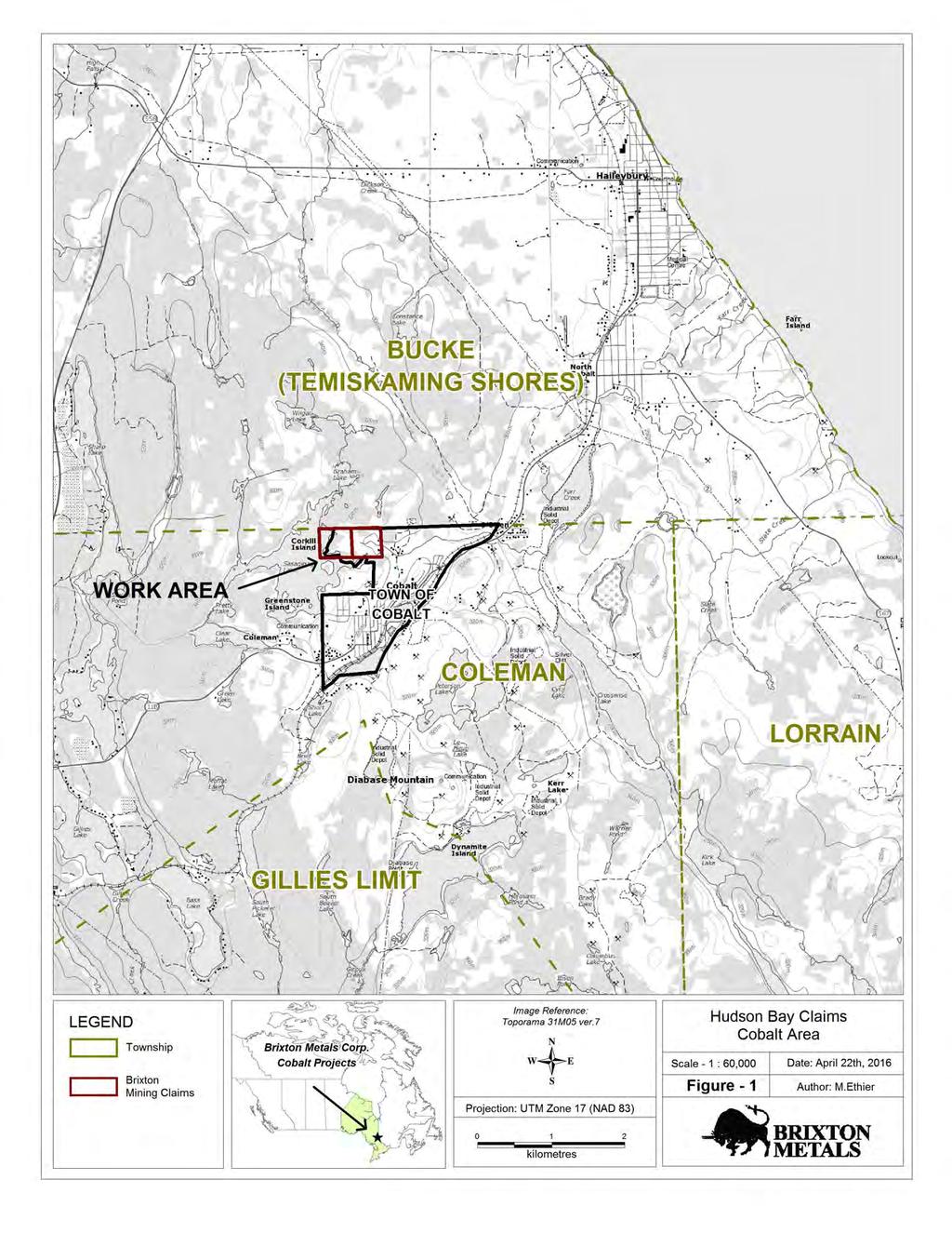
2 Assessment Report on Prospecting Conducted on the Hudson Property Canagco Mining Corporation Town of Cobalt Larder Lake Mining District UTM Zone 17 Nad 83 Projection Centred on N to N Work Conducted on Claims , Work Conducted From March 31 st, 2016 to April 25th, 2015 Prepared by: Martin Ethier, MSc. Hinterland Geoscience & Geomatics For: Brixton Metals Corporation 25 April 2016
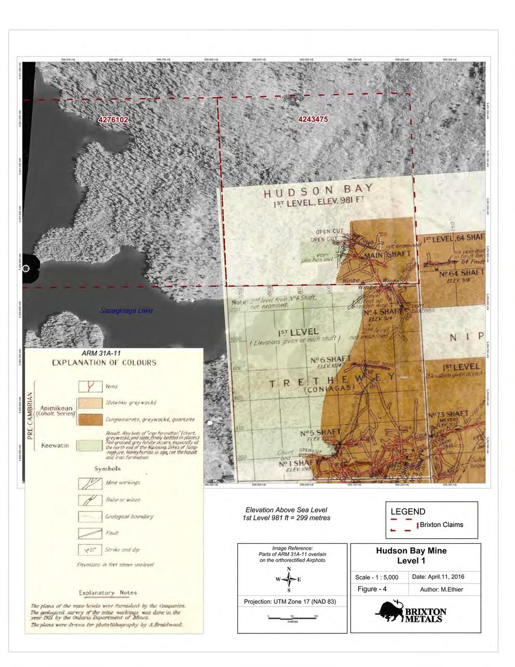
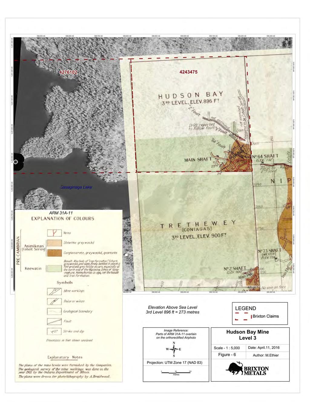
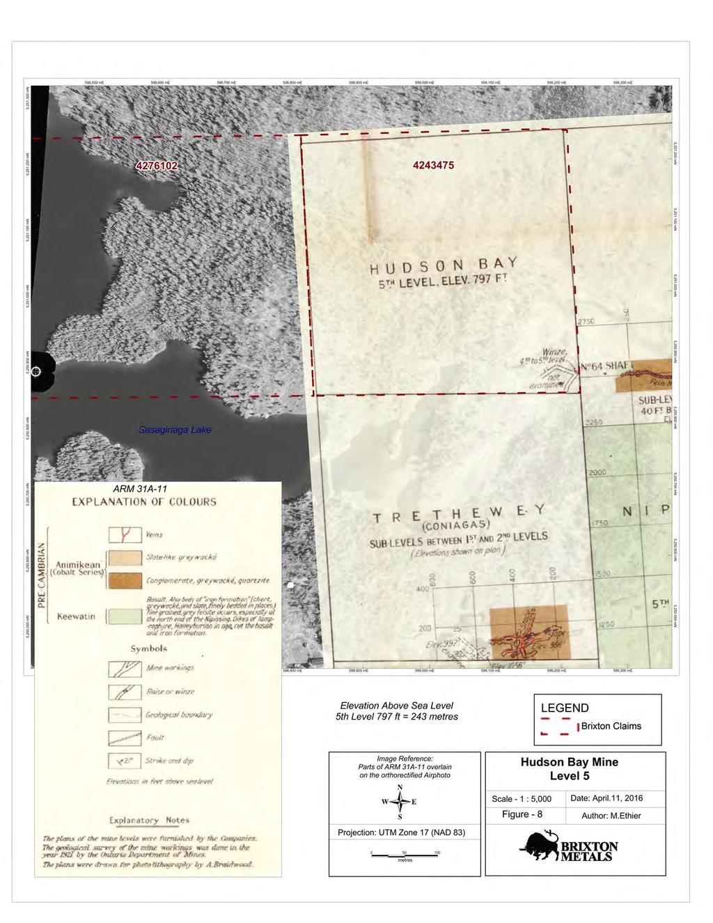
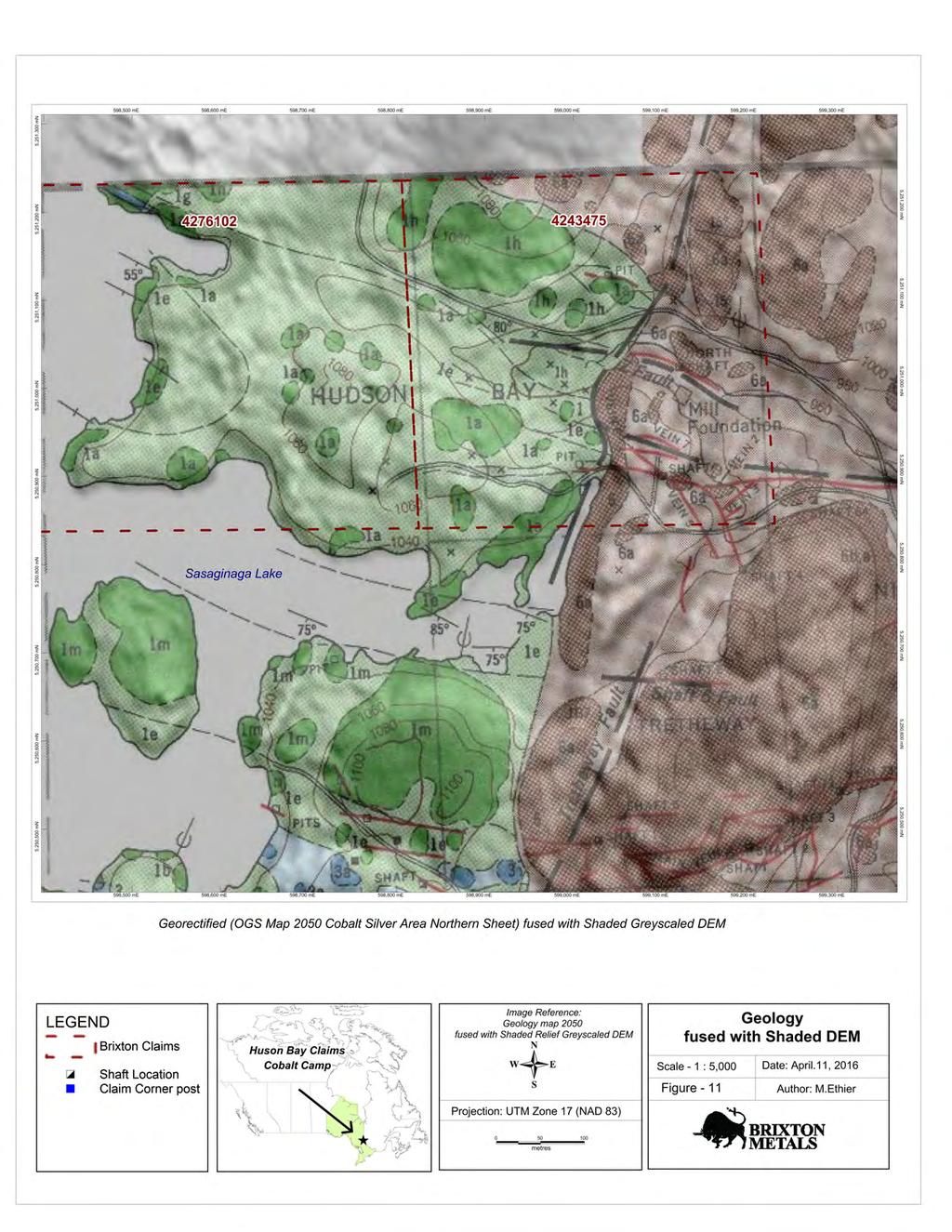
3 TABLE OF CONTENTS Summary...3 Property Description and Location...3 Property Geology and History...5 Prospecting...5 Data Capture and Integration...9 List of Personnel...10 LIST OF FIGURES Figure 1. Hudson Bay Claims, Cobalt Area...4 Figure 2. Shaft Locations, fenced mine workings & geology...6 Figure 3. Digital Elevation Model fuse with Airphoto...11 Figure 4. Hudson Bay Mine Level Figure 5. Hudson Bay Mine Level Figure 6. Hudson Bay Mine Level Figure 7. Hudson Bay Mine Level Figure 8. Hudson Bay Mine Level Figure 9. Hudson Bay Mine Below Level Figure 10. Magnetic Data Fused with Airphoto...18 Figure 11. Geology Fused with Shaded DEM...19
4 Summary Brixton Metals Corp. is exploring for minerals on several blocks of contiguous mining patents/mining claims covering parts of six townships (Bucke, Coleman, Gillies Limit, Lorrain, Harris and Casey) in the historic Cobalt Mining Camp. This report consists of ground-truthing as well as ground control positioning (airphoto orthorectification), production of a detailed elevation model (DEM) and the creation of multiple composite maps while integrating these data within a geographical information system (GIS). This data integration resulted in an additional understanding of the areas geological context, especially within the underground mine workings context. The costs of the labor described above, plus the direct costs of planning the work, writing and producing this report are filed herein as assessment work. This work will help devise all future exploration efforts especially with the requirements for carrying exploration plans and permits. No permits were needed to perform this work. Property Description and Location The Hudson Bay Mine claim is located at the extreme north-end of the Town of Cobalt within the limits of the municipality and is bounded to the north by Bucke twp boundary (City of Temiskaming Shores). Claims # & are easily accessed by gravel road into the property via streets within the Town of Cobalt. Claim is bounded by Sasaginaga Lake to the west. On April 01 st, 2006 the author collected simple GPS waypoint using a Garmin GPS MAP76 near shafts located in the study area and after the snow/ice melts on April 22th, 2006 a more precise differential GPS was used. All the shaft areas are fenced off, therefore difficult to get precise measurements. Estimation to the centre of the shaft was determined using compass and Differencial GPS point. It must be noted that the shaft location matched up satisfactorily over the orthorectified airphoto (Figure 2). All available maps showed the north shaft north m north of the fenced off area, but recently the wood capped shaft collapsed was rediscovered. 3
5 4
6 Property Geology & History The Hudson Bay Mine is a former mine operation that is located in the northern portion of Coleman Township inside the Town of Cobalt. Two unpatented mining claims cover the former Hudson Bay Mine site: Claim # and # The mine operated from 1905 to 1943 and again in 1953 which produced a total of 6,452,266 oz of Silver and 185,572 lbs of Cobalt. (Sergiades, 1968) The average grade mined from was 123 oz/ton Ag (Sergiades, 1968). Production came from primarily two veins systems: Vein #1 and Vein #2 both had a strike length of 400ft and extended 200ft vertically (Sergiades, 1968). There is an unknown, small amount of tailings left on the property. However, in a report summarizing mine and mill production in the Cobalt Mining Camp, the Hudson Bay Mill produced 129,278 tons ( ), (Anderson, 1993); and the Trethewey Mill produced 235,575 tons ( ), (Anderson, 1993). Both mills' tailings flow via the Hudson Bay tailings catchment area. There is also, an unknown amount of broken waste rock piles located on the Hudson Bay Property. All shafts and open cuts are fenced or capped. The Hudson Bay Mine property is positioned adjacent to three former mine producers: Trethewey Mine (Claim JB#7) and Coniagas Mine (Claim JB #6) both are located to the south, and the Ferland Chambers Property that is located to the east. All three former mines are currently held by Agnico-Eagle Mines Ltd. Open pit production from the Coniagas-Trethewwy property that operated sporadically from 1978 to Prospecting In order to effectively do more advance work on the property, precise locations of mine workings/ shafts, claim boundaries and possible geological contacts needed to be established. To start with, an exact corner pin from the Ontario Crown Lands Surveys was located. It determines the bounds of JB7 to the south, and RL400 to the east. The April 2016 MNDM CLAIMAP boundary is 20m northeast of actual boundary (fig 2). The other corner pins where not found, it is recommended to locate them in the future. 5
7 6
 All available maps showed the north shaft north 20-45 m north of the fenced off area and present location, but recently")

8 UTM Nad83, ellipsoid height (599, E, 5,250, N, ellheight: 274.5) All available maps showed the north shaft north m north of the fenced off area and present location, but recently the moss camouflaged wood capped shaft collapsed was able to be rediscovered. The surrounding area is extremely dangerous and only within 4 feet of the fenced off area. UTM Nad83, ellipsoid height-centre of shaft (2.2m east 70 of point below) (599, E, 5,251,016.26N, ellheight: 265.1) 7
 (599,273.")

9 In order to be certain of location, some workers refer to this other shaft as the main shaft, but unquestionably it is the shaft known as N 64. By locating the boundary pin, this shaft is not part of the Hudson Bay Claim. UTM Nad83, ellipsoid height-centre of shaft pipe (4m east 90 of point below) (599, E, 5,250, N, ellheight: 270.3) Another open shaft (fenced off) was located and was determined to be the N 04 shaft. The shaft was also determined to be approximately 35 m south of the claim boundary. UTM Nad83, ellipsoid height-centre of shaft opening (4.5m southeast 140 of point below) (599, E, 5,250, N, ellheight: 278.4) 8
10 Main Post X Y Ellheight The main 8 ft high chain link fence was mapped using the major fence post. Like the shafts, the data was captured using differential GPS. The entirety of the fenced area is underlain by conglomerate rocks and has a lower magnetics signature compared to the fine grained sediments, most likely volcanic ash sequence to the west (see fig 2). Data Capture and Integration Even though the Hudson Bay claim area has easy access, there are not many comprehensive information and maps that have been generated. The other objective of this report was too accurately position in UTM space the readily available data. In a previous assessment report, an othophoto was generated from multiple airphoto For this report, a detailed digital elevation model (DEM) was constructed (5m pixel) using this data. The elevation data was extracted from the stereo pair of images which are adjacent images of the same area taken from different viewpoints. This method was very useful in creating the detailed DEM/3D surface. After the image (map) layers were geo-corrected, processed and clipped to coincide with the study area the next step was to manipulate the data to maximise their interpretation and integrate them. GPS shaft locations were used as the ground control points, and an excellent georectified correlation was produced in all the images. In order to facilitate future work in the area, it is recommended that the area be investigated by detailed UAV (drone) survey (cm-dm accuracy) 9
11 A Series of comprehensive maps were created with the airphoto mosaic and the detailed DEM. Figure 3. Digital Elevation Model fused with Airphoto Figure 4. Hudson Bay Mine Level 1 Figure 5. Hudson Bay Mine Level 2 Figure 6. Hudson Bay Mine Level 3 Figure 7. Hudson Bay Mine Level 4 Figure 8. Hudson Bay Mine Level 5 Figure 9. Hudson Bay Mine Below Level 5 Figure 10. Magnetic Data Fused with Airphoto Figure 11. Geology Fused with Shaded DEM List of Personnel Martin Ethier, M.Sc. géo Hinterland Geosience & Geomatics P.O. Box 304 Haileybury ON, P0J 1K0 10
12 11
13 12
14 13
15 14
16 15
17 16
18 17
19 18
20 19
We are committed to providing accessible customer service. If you need accessible formats or communications supports, please contact us.
 We are committed to providing accessible customer service. If you need accessible formats or communications supports, please contact us. Nous tenons à améliorer l accessibilité des services à la clientèle.
We are committed to providing accessible customer service. If you need accessible formats or communications supports, please contact us.
 We are committed to providing accessible customer service f you need accessible formats or communications supports please contact us Nous tenons à améliorer l accessibilité des services à la clientèle
We are committed to providing accessible customer service. If you need accessible formats or communications supports, please contact us.
 We are committed to providing accessible customer service. If you need accessible formats or communications supports, please contact us. Nous tenons à améliorer l accessibilité des services à la clientèle.
We are committed to providing accessible customer service. If you need accessible formats or communications supports, please contact us.
 We are committed to providing accessible customer service. If you need accessible formats or communications supports, please contact us. Nous tenons à améliorer l accessibilité des services à la clientèle.
Report of Gridding and Magnetic Surveys. On the. Munro Property. Munro and Beatty Townships, Ontario. Larder Lake Mining Division
 Report of Gridding and Magnetic Surveys On the Munro Property Munro and Beatty Townships, Ontario Larder Lake Mining Division Claims: 39 4244 For Big Red Diamond Corporation October 3, 2 Timmins, Ontario
We are committed to providing accessible customer service. If you need accessible formats or communications supports, please contact us.
 We are committed to providing accessible customer service. If you need accessible formats or communications supports, please contact us. Nous tenons à améliorer l accessibilité des services à la clientèle.
PROSPECTING Survey Over the AULD PROPERTY Auld Township, Ontario
 PO Box 219, 14579 Government Road, Larder Lake, Ontario, P0K 1L0, Canada Phone (705) 643-2345 Fax (705) 643-2191 www.cxsltd.com PROSPECTING Survey Over the AULD PROPERTY C Jason Ploeger, B.Sc, P.Geo August
We are committed to providing accessible customer service. If you need accessible formats or communications supports, please contact us.
 We are committed to providing accessible customer service. If you need accessible formats or communications supports, please contact us. Nous tenons à améliorer l accessibilité des services à la clientèle.
DiaMine Exploration Inc. Pickle Lake Option Property
 DiaMine Exploration Inc. Pickle Lake Option Property Rock Sampling Program and Field Observations Claims 4249174, 4249175, 4249176 and 4249177, Kapkichi Lake Area (G-2081) And Claims 4249178, 4249179 and
We are committed to providing accessible customer service. If you need accessible formats or communications supports, please contact us.
 We are committed to providing accessible customer service. If you need accessible formats or communications supports, please contact us. Nous tenons à améliorer l accessibilité des services à la clientèle.
Report on Prospecting on Claims & in the Federal Mine Property Teck Township Larder Lake Mining Division.
 1 Report on Prospecting on Claims 1227076 & 1222223 in the Federal Mine Property Teck Township Larder Lake Mining Division July 19, 2015 2 Table of Contents Introduction... 3 Summary... 3 Property Descriptions
r ffj Ronald C. Wells, BSc. Lacana Mining Corporation LACANA CLAIMS GAUTMER TOWNSMP GEOPHYSICAL REPORT OCT LARDER LAKE MINING DIVISION
 a- 32D04NWei39 2.3507 GAUTHIER 010 GEOPHYSICAL REPORT LACANA CLAIMS GAUTMER TOWNSMP LARDER LAKE MINING DIVISION RECEIVED OCT171980 MINING UNDS SECTION Author: Ronald C. Wells, BSc. Lacana Mining Corporation
FOCUSED ON ACQUIRING, EXPLORING AND ADVANCING QUALITY MINING PROJECTS IN THE AMERICAS CORPORATE PRESENTATION 1
 FOCUSED ON ACQUIRING, EXPLORING AND ADVANCING QUALITY MINING PROJECTS IN THE AMERICAS JUNE 2018 CORPORATE PRESENTATION 1 Disclaimer Except for the statements of historical fact contained herein, certain
lin iibii i nm l i 31M05SE A.446 GILLIES 010
 ..-... lin iibii i nm l i 31M05SE0892 63A.446 GILLIES 010 t GEOLOGICAL REPORT ON HOUND CHUTE LAKE PROPERTY OF SILVER TOWER MINES LIMITED GILLIES LIMIT COBALT, ONTARIO (p Z A The property is located n Blocks
We are committed to providing accessible customer service. If you need accessible formats or communications supports, please contact us.
 We are committed to providing accessible customer service. If you need accessible formats or communications supports, please contact us. Nous tenons à améliorer l accessibilité des services à la clientèle.
Institutional Control Registry - Report
 Institutional Control Registry - Report IC REGISTRY ICR # ICR - 01 Date of Acceptance May 11, 2009 Contact Lake Mine Cameco Corporation Cameco Corporation La Ronge 73-P-07 UTM-North 6141199 UTM-East 507983
Introducti on. Land Survey. Geomagnetic Survey. Geomagnetic Results and Interpretati ons - Conclusions and Recommendations C
 m M 42A86SW8281 63.42 PRICE 010 C O H T E H l 42A86SW828I 63.42 PRICE 010C Introducti on Land Survey Geomagnetic Survey Geomagnetic Results and Interpretati ons - Conclusions and Recommendations - - -
We are committed to providing accessible customer service. If you need accessible formats or communications supports, please contact us.
 We are committed to providing accessible customer service. If you need accessible formats or communications supports, please contact us. Nous tenons à améliorer l accessibilité des services à la clientèle.
Queenston intersects Contact Zone on the Pandora Property and new gold zones in Kirkland Lake
 1 Queenston intersects Contact Zone on the Pandora Property and new gold zones in Kirkland Lake TORONTO, Ontario, March 7, 2003. Queenston Mining Inc. (QMI-TSX) reports diamond drill results on its 100%
WORK REPORT. on the ALEXO PROPERTY DUNDONALD TOWNSHIP PORCUPINE MINING DIVISION. for LIBERTY MINES INC.
 GEOSCIE CE AS r::;ss lent OFFICE WORK REPORT on the ALEXO PROPERTY DUNDONALD TOWNSHIP PORCUPINE MINING DIVISION for LIBERTY MINES INC. 2. 340 51 Submitted by: Steve Anderson VISION EXPLORATION 2041663
MRD 229-Revised METADATA
 GENERAL INFORMATION MRD 229-Revised METADATA Official Name of the Data Set or Information Holding: Till Compositional Database: Investigation of the Overburden Signature of the Caribou Lake Greenstone
We are committed to providing accessible customer service. If you need accessible formats or communications supports, please contact us.
 We are committed to providing accessible customer service. If you need accessible formats or communications supports, please contact us. Nous tenons à améliorer l accessibilité des services à la clientèle.
TECHNICAL REPORT ON THE BLACK CREEK PROPERTY FOR CARRIE ARRAN RESOURCES BLACK TOWNSHIP LARDER LAKE MINING DIVISION ONTARIO
 TECHNICAL REPORT ON THE BLACK CREEK PROPERTY FOR CARRIE ARRAN RESOURCES BLACK TOWNSHIP LARDER LAKE MINING DIVISION ONTARIO B.J. McKay, 8 February 2011 Keewatin, Ontario TECHNICAL REPORT BJML 2011 Table
MRD 228 METADATA. Official Name of the Data Set or Information Holding: Physiography of Southern Ontario
 MRD 228 METADATA GENERAL INFORMATION Official Name of the Data Set or Information Holding: Physiography of Southern Ontario Acronyms are Used to Identify the Data Set or Information Holding: MRD228 Describe
TIGER GOLD EXPLORATION CORPORATION. Prospecting Over the HARKER HERITAGE PROPERTY AREA 10. Harker Township, Ontario
 PO Box 219, 14579 Government Road, Larder Lake, Ontario, P0K 1L0, Canada Phone (705) 643-2345 Fax (705) 643-2191 www.cxsltd.com TIGER GOLD EXPLORATION CORPORATION Prospecting Over the HARKER HERITAGE PROPERTY
Assessment Report by the Canadian Nickel Co. Ltd. Magnetometer Survey. Larder Lake Mining Division Lebel Tovnship, Ontario
 32084Nwea67 2.331* LEBEL 010 Assessment Report by the Canadian Nickel Co. Ltd. Magnetometer Survey Larder Lake Mining Division Lebel Tovnship, Ontario Claims L-531657 L-531658 L-531111 Map No.: M-359,
We are committed to providing accessible customer service. If you need accessible formats or communications supports, please contact us.
 We are committed to providing accessible customer service. If you need accessible formats or communications supports, please contact us. Nous tenons à améliorer l accessibilité des services à la clientèle.
Prospect Resources Signs Mining Agreement over Bucks Reef Gold Mine.
 Prospect Resources Signs Mining Agreement over Bucks Reef Gold Mine. HIGHLIGHTS Prospect Resources has secured the mining rights to the Bucks Reef Gold Mine, which lies some 600m west of its Prestwood
LUCKY BEN MINE PROJECT SEPTEMBER 2018 UPDATE
 LUCKY BEN MINE PROJECT SEPTEMBER 2018 UPDATE During the first week of July 2018 work was completed by our Geologist, Richard Morris, and support personnel to stake the Lucky Ben vein structure at surface
NI TECHNICAL REPORT ON THE TELEDYNE COBALT PROJECT LARDER LAKE MINING DIVISION, NORTHEASTERN ONTARIO LICO ENERGY METALS INC. FOR.
 NI 43-101 TECHNICAL REPORT ON THE TELEDYNE COBALT PROJECT LARDER LAKE MINING DIVISION, NORTHEASTERN ONTARIO FOR LICO ENERGY METALS INC. Prepared by: Joerg Kleinboeck, P.Geo. JMK Exploration Consulting
Magnetic Field and VLF Surveys on the Shining Tree Property. Claims: , , , , , , , ,
 December 29, 2014 NTS: 041P11 Magnetic Field and VLF Surveys on the Shining Tree Property Claims: 1203361, 4251801, 4251803, 4251805, 4263067, 4263068, 4270940, 4270436, 4276740 Churchill and Asquith Townships
Amador Canyon Silver Mining Property Lander County, NV
 Amador Canyon Silver Mining Property Lander County, NV Over $1 million worth of exploration and evaluation work performed Favorable drill results including a return of 286 g/ton silver over 12.2 meters
National Instrument Technical Report
 National Instrument 43-101Technical Report Pigeon River Property Hartington Township Ontario, Canada Thunder Bay Mining Division, NTS 42A4 Geology Updated Technical Report UTM: Zone 16, 277134m E, 5332229m
RECEIVED. tn r-"t."' Magnetometer and VLF-EM Surveys Assessment Report. South Cobalt Silver Project South Lorrain Twp. Mhakari Gold Corp.
 RECEVED APR 1 5 111 OOSC!C! AESSMET tn r-"t. Magnetometer and VLF-EM Surveys Assessment Report South Cobalt Silver Project South Lorrain Twp. Mhakari Gold Corp. March 211 TS 31 M/3-4 Meegwich Consultants
July Exploring for Canadian Gold in the Rainy River District of Ontario
 July 2013 Exploring for Canadian Gold in the Rainy River District of Ontario 1 Forward Looking Statements Some of the statements in this document may be deemed to be "forward-looking statements". All statements
Scadding Property Sudbury District, Ontario
 FOR IMMEDIATE RELEASE Northern Sphere Mining Corp. optimizes mineral targets on its Sudbury Nickel Belt and Arizona Porphyry Copper properties Toronto, Ontario April 5, 2018 - Northern Sphere Mining Corp.
A New Direction. Copper-Gold Deposit at Thor TSX.V:COL. August 11, May 2013
 A New Direction Copper-Gold Deposit at Thor August 11, 2016 May 2013 TSX.V:COL FORWARD LOOKING STATEMENTS This presentation includes certain forward-looking information or forward-looking statements for
Public Land Survey System Knowledge Remains an Important Skill
 By Douglas S. Helmke, P.G., Water Rights / Source Water Specialist Public Land Survey System Knowledge Remains an Important Skill In our new world of global positioning system (GPS) navigation, with digital
The MAPLE BAY PROJECT Copper Silver - Gold
 The MAPLE BAY PROJECT Copper Silver - Gold Good grade and tonnage potential within close proximity to Tidewater The Maple Bay Copper Silver Gold Project covers highly favourable geological host rocks of
This material is part of the collection of the Philadelphia Water Department and was downloaded from the website Please contact the
 This material is part of the collection of the Philadelphia Water Department and was downloaded from the website www.phillyh2o.org Please contact the PhillyH2O webmaster for more information about this
Great Atlantic Rock Samples Return up to 5.8 oz. / ton Gold Golden Promise Property in Central Newfoundland
 Great Atlantic Rock Samples Return up to 5.8 oz. / ton Gold Golden Promise Property in Central Newfoundland FOCUSED ON EXPLORING ATLANTIC CANADA (TSXV : GR) (FRA: PH01) VANCOUVER, British Columbia August
Nortec Minerals announces Option to acquire 100% interest in the Cottonwood Vanadium-Uranium Project, Utah
 Nortec Minerals announces Option to acquire 100% interest in the Cottonwood Vanadium-Uranium Project, Utah Vancouver, BC / The Newswire / March 8, 2019 (the Company or Nortec ) (TSXV: NVT): Nortec announces
Summary of Rover Metals Geologic Mapping Program at the Up Town Gold Project, Northwest Territories
 October 13, 2017 Summary of Rover Metals Geologic Mapping Program at the Up Town Gold Project, Northwest Territories Vancouver, British Columbia, Canada - Rover Metals Corp., Rover, is pleased to provide
Montgomery Bedrock Geology 21d-Gowganda Formation: conglomerate, sandstone, siltstone, argillite
 Work Report 2014 Trenching Montgomery Township G-3303 Claim #4259384,4245818 Sault Ste. Marie Mining Division Michael & Yvon Gagne Montgomery Copper Property 1 P a g e 2 P a g e Montgomery Bedrock Geology
RECEIVED JUN REPORT ON GEOLOGICAL MAPPING on Claim BUCKE TOWNSHIP, ONTARIO for Cabo Mining Enterprises Corp.
 REPORT ON GEOLOGICAL MAPPING on Claim 1193781 BUCKE TOWNSHIP, ONTARIO for Cabo Mining Enterprises Corp. June, 2004 Seymour M. Sears, P.Geo. RECEIVED JUN 2 9 2004 GEOSCIENCE ASSESSMENT OFFICE 31M05NE2028
REPORT ON GEOPHYSICAL SURVEYS ON THE BAMAJI LAKE PROPERTY CROBIE PROJECT, NW ONTARIO OF UMEX INC.
 S20e3NWe«28 S20«3NWee37 FRY LAKE 0 1 0 REPORT ON GEOPHYSICAL SURVEYS ON THE BAMAJI LAKE PROPERTY CROBIE PROJECT, NW ONTARIO OF UMEX INC. Patricia Mining Division NTS 52 0/3 Latitude 51 10'N Longitude 91
EXPLORATION & DEVELOPMENT
 EXPLORATION & DEVELOPMENT ZINC LEAD SILVER GOLD COPPER PRAIRIE CREEK MINE PERMITTING COMPLETED PRAIRIE CREEK MINE, NORTHWEST TERRITORIES NEWFOUNDLAND PROJECTS www.canadianzinc.com invest@canadianzinc.com
COAU PROPERTY LEMHI COUNTY, IDAHO
 COAU PROPERTY LEMHI COUNTY, IDAHO Utah Mineral Resources 447 N 300 W, Suite 3 Kaysville, UT 84037 (801) 544-3421 ojgatten@nae-xploration.com Prepared by: North American Mine Services, LLC. March 21, 2017
NOA ASSESSMENT HARRIS QUARRY MENDOCINO COUNTY, CALIFORNIA TABLE OF CONTENTS
 NOA ASSESSMENT HARRIS QUARRY MENDOCINO COUNTY, CALIFORNIA TABLE OF CONTENTS Introduction... 1 Scope of Services... 1 Project Location and Description... 1 Geologic Setting... 1 Regional Geology... 1 Site
We are committed to providing accessible customer service. If you need accessible formats or communications supports, please contact us.
 We are committed to providing accessible customer service. If you need accessible formats or communications supports, please contact us. Nous tenons à améliorer l accessibilité des services à la clientèle.
SKEAD HOLDINGS LTD. Prospecting Over the. PUSEY LAKE PROPERTY Cardiff Township, Ontario
 PO Box 219, 14579 Government Road, Larder Lake, Ontario, P0K 1L0, Canada Phone (705) 643-2345 Fax (705) 643-2191 www.cxsltd.com SKEAD HOLDINGS LTD. Prospecting Over the PUSEY LAKE PROPERTY Cardiff Township,
NEWS RELEASE DRILLING AT GOLD CANYON S SPRINGPOLE GOLD PROJECT PRODUCES MORE LONG GOLD AND SILVER INTERCEPTS
 GOLD CANYON RESOURCES INC. GCU: TSX-V Suite 810-609 Granville Street, P.O. Box 1036 Pacific Centre, Vancouver, BC, Canada V7Y 1G Tel: (604) 682-3234 Toll free: 1 (888) 242-3234 Fax: (604) 682-037 www.goldcanyon.ca
SUPPLEMENT TO MAGNETOMETER 6 ELECTROMAGNETIC SURVEY REPORT. DATED NOVEMBER l, 1973 CIGLEN INVESTMENTS LIMITED CLAIMS GROUP BAD VERMILLION LAKE AREA
 ^ A R l ^ 1974 010 PROJECTS UNIT SUPPLEMENT TO MAGNETOMETER 6 ELECTROMAGNETIC SURVEY REPORT DATED NOVEMBER l, 1973 CIGLEN INVESTMENTS LIMITED CLAIMS GROUP BAD VERMILLION LAKE AREA DISTRICT OF RAINY RIVER
Prospect Resources completes rehabilitation and mine construction at the Prestwood Gold Mine - moving into production mode
 Prospect Resources completes rehabilitation and mine construction at the Prestwood Gold Mine - moving into production mode Summary The main shaft at the Prestwood mine has been fully rehabilitated to 4
MANN SILVER-COBALT MINE. PORE: TSXV PowerOre.com
 MANN SILVER-COBALT MINE PORE: TSXV PowerOre.com FORWARD LOOKING STATEMENTS We are in the mineral exploration and development business. It is inherently risky, and all potential investors should be keenly
GEOPHYSICAL DATA SET (GDS) 1084B METADATA
 1084B METADATA") GEOPHYSICAL DATA SET (GDS) 1084B METADATA GENERAL INFORMATION Official Name of the Data Set or Information Holding: Ontario Airborne Geophysical Surveys, Magnetic Gradiometer and Gamma-Ray Spectrometric
GEOPHYSICAL DATA SET (GDS) 1084B METADATA GENERAL INFORMATION Official Name of the Data Set or Information Holding: Ontario Airborne Geophysical Surveys, Magnetic Gradiometer and Gamma-Ray Spectrometric
Melkior Drills Shallow Holes on Zam Zam and Jowsey Gold Zones and Intersects 33.1 g/t over 1.18 Metres
 Melkior Drills Shallow Holes on Zam Zam and Jowsey Gold Zones and Intersects 33.1 g/t over 1.18 Metres July 26, 2016 Trading Symbol: MKR TSX Venture Exchange Ottawa, Ontario. Melkior Resources Inc. ( Melkior
We are committed to providing accessible customer service. If you need accessible formats or communications supports, please contact us.
 We are committed to providing accessible customer service. If you need accessible formats or communications supports, please contact us. Nous tenons à améliorer l accessibilité des services à la clientèle.
Town of Chino Valley. Survey Control Network Report. mgfneerhg mc N. Willow Creek Road Prescott AZ
 Town of Chino Valley Survey Control Network Report mgfneerhg mc. 2050 N. Willow Creek Road Prescott AZ 86301 928-771-2376 Page 1 of 70 Table of Contents Town of Chino Valley Survey Datum Outline A short
City of Six Project. Gold Mining Property in Downieville, CA. 60 Acres of Claims. Estimated Resource of over 8,800 ounces of Gold
 City of Six Project Gold Mining Property in Downieville, CA 60 Acres of Claims Estimated Resource of over 8,800 ounces of Gold Adjoining the famous Ruby Mine Property Located on a Rich Tertiary Channel
Pacific Empire Minerals Provides Copper King RC Drilling Results
 Pacific Empire Minerals Provides Copper King RC Drilling Results November 1, 2018 - Vancouver, BC, Canada - Pacific Empire Minerals Corp. (TSXV: PEMC) ( Pacific Empire, PEMC or the Company ), a hybrid
Total Magnetic Field and VLF Surveys on the Swayze Property. Claim Swayze Township. Porcupine Mining Division
 1 January, 016 NTS: 041 O 15 Total Magnetic Field and VLF Surveys on the Swayze Property Claim 475471 Swayze Township Porcupine Mining Division 380850E, 599450N UTM Z17N NAD83 Report Prepared for: 540
Timiskaming Health Stats
 Timiskaming Health Stats Geographic Description of the Timiskaming Health Unit Area Released August 2014 Introduction This report presents a geographic description for the Timiskaming Health unit catchment
7 MILES WEST OF PORT HARDY, B.C.
 GEOPHYSICAL REPORT VERTICAL INTENSITY MAGNETOMEER SURVEY ON LUK CLAIMS, 7 MILES WEST OF PORT HARDY, B.C. 50' 127O SE BY R. E. SHIELDS UNDER SUPERVISION OF J. R. BILLINGSLEY FOR SECOND0 MINING LTD. (N.
2014 AEROQUEST AIRBORNE HELI-BORNE VTEM PLUS AND HORIZONTAL MAGNETIC GRADIOMETER SURVEY ASSESSMENT REPORT CAMERON GOLD PROJECT
 2014 AEROQUEST AIRBORNE HELI-BORNE VTEM PLUS AND HORIZONTAL MAGNETIC GRADIOMETER SURVEY ASSESSMENT REPORT CAMERON GOLD PROJECT PREPARED BY: Nick Walker. January 2015 SUMMARY This report presents the results
PRESS RELEASE WESDOME PLANS AGGRESSIVE DRILLING AND DEVELOPMENT PROGRAM IN 2011
 PRESS RELEASE WESDOME PLANS AGGRESSIVE DRILLING AND DEVELOPMENT PROGRAM IN 2011 Toronto, Ontario March 30, 2011 Wesdome Gold Mines Ltd (WDO: TSX) has initiated an aggressive exploration, development and
CHAMPION BEAR RESOURCES
 CHAMPION BEAR RESOURCES EXPLORING ADVANCED STAGE PRECIOUS METAL PROPERTIES IN ONTARIO Exploration Update January 2011 Forward Looking Statements This exploration update contains forward looking statements
AGGREGATE RESOURCES OF ONTARIO (ARO) METADATA
 METADATA") AGGREGATE RESOURCES OF ONTARIO (ARO) METADATA GENERAL INFORMATION Official Name of the Data Set or Information Holding: Aggregate Resources of Ontario Acronyms are Used to Identify the Data Set or Information
AGGREGATE RESOURCES OF ONTARIO (ARO) METADATA GENERAL INFORMATION Official Name of the Data Set or Information Holding: Aggregate Resources of Ontario Acronyms are Used to Identify the Data Set or Information
PROSPECTING REPORT. Deneau Creek. EVENT # TENURE # Tenure Name: Deneau Creek. New Westminster Mining Division Map 092H
 2010-2011 PROSPECTING REPORT Deneau Creek EVENT # 4844921 TENURE # 578616 Tenure Name: Deneau Creek New Westminster Mining Division Map 092H Central Coordinate Reference 121 18 04.5 W Longitude 49 26 13.9
DUNNEDIN VENTURES INC.
 . PST Kimberlite First Diamond Results November 2015 1 FORWARD LOOKING STATEMENT Except for historical information contained herein, this presentation may contain forward-looking statements including but
Lab Topographic Maps. Name: Partner: Purpose. Background Information
 Lab Topographic Maps Name: Partner: Purpose The purpose of this lab is to familiarize you with graphic representations of the Earth s surface primarily maps. Simple line maps show the spatial relationship
Simplified exploration work report
 Simplified exploration work report Work Report of exploration and examination of outcrops of rock and boulders Report on stripping and excavating work of $ 5 000 or less.(section 81 of regulation) Report
MRD 207 METADATA DETAIL PAGE
 MRD 207 METADATA DETAIL PAGE The following represents the Basic description of an information holding. To obtain more information about this holding, see the section named Contacts. GENERAL INFORMATION
Northern Sphere Mining Corporation NSM FOCUSED DEVELOPMENT - SUSTAINABLE GROWTH
 Northern Sphere Mining Corporation NSM FOCUSED DEVELOPMENT - SUSTAINABLE GROWTH NORTHERN SPHERE MINING CORP. ( NORTHERN SPHERE OR NSM ) FORWARD LOOKING STATEMENT This presentation includes certain statements
MRD-160 METADATA DETAIL PAGE
 MRD-160 METADATA DETAIL PAGE The following represents the Basic description of an information holding. To obtain more information about this holding, see the section named Contacts. GENERAL INFORMATION
HY LAKE GOLD INTERSECTS 1.0 METRES OF GRAMS PER TONNE GOLD FROM ROWAN PROPERTY ROWAN MINE SYSTEM STRIKE LENGTH EXTENDED TO MINIMUM 800m
 NES ELEASE CNSX: YL FANKFT: YK Y LAKE GOLD INTESECTS. METES OF 4.5 GAMS PE TONNE GOLD FOM OAN POPETY OAN MINE SYSTEM STIKE LENGT EXTENDED TO MINIMM 8m FO IMMEDIATE ELEASE, February 6, Toronto, Ontario.
SUMMARY REPORT. ESSAR STEEL ALGOMA INC. 105 West Street, Sault Ste. Marie, Ontario, Canada P6A 7B4
 SUMMARY REPORT IRON LAKE PROPERTY Keating and Keating Additional Townships, Ontario, Canada ESSAR STEEL ALGOMA INC. 105 West Street, Sault Ste. Marie, Ontario, Canada P6A 7B4 Date: March 18, 2013 Prepared
REPORT OF PHYSICAL EXPLORATION AND DEVELOPMENT Section 15 - Mineral Tenure Act Regulation
 1. EVENT NUMBER(S) 1234567 4. RECORDED HOLDER Doe 123 Main Street REPORT OF PHYSICAL EXPLORATION AND DEVELOPMENT Section 15 - Mineral Tenure Act Regulation Mineral Titles and Policy Branch Ministry of
KIRKLAND LAKE GOLD INTERSECTS NEW MINERALIZATION AT TAYLOR MINE, CONTINUES TO EXTEND PORPHYRY DEPOSITS TO DEPTH
 KIRKLAND LAKE GOLD INTERSECTS NEW MINERALIZATION AT TAYLOR MINE, CONTINUES TO EXTEND PORPHYRY DEPOSITS TO DEPTH Drilling identifies gold-bearing quartz veins at multiple locations up to 1.8 km east of
TIGER GOLD EXPLORATION CORPORATION. Prospecting Over the HARKER HERITAGE PROPERTY AREA 1. Clifford Township, Ontario
 PO Box 219, 14579 Government Road, Larder Lake, Ontario, P0K 1L0, Canada Phone (705) 643-2345 Fax (705) 643-2191 www.cxsltd.com TIGER GOLD EXPLORATION CORPORATION Prospecting Over the HARKER HERITAGE PROPERTY
PROJECT DETAILS August 2014
 PROJECT DETAILS August 2014 Executive Summary InterGroup Mining Pty Ltd has a major gold exploration project located in North Queensland, Australia, in an underexplored high gold bearing district, west
A PRELIMINARY REPORT ON THE ZYMOST2 CLAIM GROtP, TERRACE, B.C.
 NATIVE EXPLORATIONS LTD. A PRELIMINARY REPORT ON THE ZYMOST2 CLAIM GROtP, TERRACE, B.C. INTRODUCTION': The Zymoetz claim group is, at present, held under option by Native Explorations Ltd.. On the 19th
TERAS FLAGSHIP CAHUILLA PROJECT
 TERAS FLAGSHIP CAHUILLA PROJECT Cahuilla Company s Main Asset is located in mining friendly Imperial County, California. Mine Development Associates completed a NI 43-101 resource report; reporting an
POTENTIAL OF THE DONGWE COPPER GOLD PROJECT
 POTENTIAL OF THE DONGWE COPPER GOLD PROJECT By Nathan Sabao, P.Geo. September 2015 1 TABLE OF CONTENTS Page 1.0 EXECUTIVE SUMMARY 1 2.0 LOCATION 2 3.0 ACCESS 2 4.0 GEOLOGY 3 5.0 PREVIOUS DRILLING 5 6.0
SOUTHWEST & NORTHWEST EXPLORATION PROJECTS BINGHAM CANYON MINING DISTRICT
 SOUTHWEST & NORTHWEST EXPLORATION PROJECTS BINGHAM CANYON MINING DISTRICT SALT LAKE AND TOOELE COUNTIES, UTAH SUMMARY FRIDAY, MARCH 20, 2009 1 Tooele County Salt Lake County GOOGLE EARTH September, 2006
Advanced Geologic Exploration, Inc.
 Advanced Geologic Exploration, Inc. Scientists of the Earth PO Box 1956, Chester, CA 96020 Voice: (530) 258-4228 Fax (530) 258-4339 www.advancedgeologic.com January 23, 2009 Job No. G-081201 Terri Barber,
1 FILMED 1. FILE NO:!..rsrru -* -. GRAND TWO CLAIM
 FILE NO:!..rsrru -* -. GRAND TWO CLAIM REPORT ON 1993 ASSESSMENT WORK GRAND TWO CLAIM REC. NO. 301849 NELSON MINING DIVISION NTS MAP SHEET 82F6/W 49 25'51" NORTH 117 18'08" WEST 1 FILMED 1 AUTHOR: R. Jordan,
Advancing High Grade Gold Assets in Red Lake, Ontario
 Advancing High Grade Gold Assets in Red Lake, Ontario Forward Looking Statement Except for historical information contained herein, this presentation may contain forward-looking statements including but