Use and implementation of standards Formatting and viewing geological logs. Sytze van Heteren and Helen Glaves
|
|
|
- Marilyn Johns
- 5 years ago
- Views:
Transcription

1 Use and implementation of standards Formatting and viewing geological logs Sytze van Heteren and Helen Glaves

2 Pieter Bruegel the Elder, ca The Little Tower of Babel Museum Boijmans Van Beuningen, Rotterdam Why the need for standards? Confusion of Tongues: many words for sand, clay,


3 Alexander Roslin, 1775 Carolus Linnaeus Nationalmuseum, Stockholm Linnaeus introduced the method still used to formulate the scientific name of every species: binomial nomenclature

4 Tidal flat Plouescat, Brittany, France Linnaeus was a botanist, physician and zoologist and Latin was the language of science so harena we know the lugworm / fjæremark / arénicole / wadpier / Wattwurm as Arenicola marina

5 and have well-developed online registers for organisms
6 Tidal flat Plouescat, Brittany, France harena had he been a geoscientist, we would have known clastic sediment in which less than 30 percent of particles are gravel (greater than 2 mm in diameter) and the sand-to-mud (> 63 µm vs. < 63 µm in diameter) ratio is at least 1, with more than half of the particles of epiclastic origin as Arenicola marina

7 Babylon Beach Marseille, France sable zand smėlis sand liiv sabbia areia arena άμμος rërë Sand today, English is the language of science, and in the international geoscientific arena, sand is the common term for smiltis пясък piasek gaineamh


8 North Sea Petten, the Netherlands in close collaboration with the Commission for the Management and Application of Geoscience Information, Geo-Seas contributes to e- Infrastructure development in the area of Standards (data management, metadata, formats, delivery)


9 challenge is not the translation of numerical fields in databases, thanks to an even older standard: the Hindu-Arabic numerals introduced in Europe more than 1000 years ago most laboratory analyses are provided in a common language


10 North Sea Petten, the Netherlands challenge lies in translating geoscientific terms or descriptions presented as text, from various languages into English and from many different classifications into a single one within countries or even institutes, terminology has not been applied consistently; therefore, automated one-on-one translation is not always possible
")


11 fine what is (fine) sand? Grondsoorten en Delfstoffen bij Naam M.J. van der Meulen et al.


12 definition of standards for geological data-exchange formats, considering practices in the international community and at individual Geo-Seas partners among the partners, we have INSPIRE-compliant relational databases as well as collections of hand-written sheets of paper

 is a")

13 World Ocean Atlas ODV4Guide to ensure consistency, the ODV format is used as the common transfer format Ocean Data View (ODV) is a software package for the interactive exploration, analysis and visualisation of oceanographic and other geo-referenced profile or sequence data


14 Persians and Medes on a relief from Persepolis not a static set of rules set in stone user feedback, Geo-Seas partner experience and input from outside Europe for further improvement a full set of `common vocabularies


15 two types of parameters: - estimated visually - measured in fitting these to the ODV format - a balance must be struck between completeness of the downloadable data and relevance to the majority of end users - adhere as much as possible to international standards for the classification of geological data


16 Core from the Port of Rotterdam lithological characteristics listed in core logs, focusing on the macroscopic description of sediment per depth interval essential elements: position and water depth, depth interval of the layer, main lithology also included: admixtures of secondary material, colour, median grain size, sorting and sedimentary structures


17 Udden-Wentworth and modified Folk classifications organic units are gyttja and peat for clastic units, the most commonly used classification system for main lithology is the Udden- Wentworth scale (Udden, 1914; Wentworth, 1922); the most commonly used system to describe admixtures is the Folk classification (Folk, 1954)

18 Shells in Zeeland specific issues: - non-clastic sediments such as peat and gyttja - differentiation between gravel-sized shells / shell fragments and siliciclastic gravel English North Sea coast


19 Munsell system colour provides: - information on depositional conditions - commonly assigned using subjective methods, and entered as text link to ISCC-NBS System of Color Designation, naming colours - objective method for assigning colour is the Munsell colour system, adopted by the USDA The Color Purple


20 Sorting additional parameters: - median grain size - sorting - sediment structures Netherlands coastal dunes


21 Pollen diagram analyses and measurements: - dating results - grain-size analyses - micropalaeontology - geochemistry - geotechnical characteristics numeric values easy to transfer metadata on methodology important Grain-size curves

22 GeoSciML definition of sand CGI/GeoSciML vocabs are listed on t.html SeaDataNet vocabs on ome.aspx/ in anticipation of a future shift to GeoSciML, it is wise to use and create transfer formats that share codes we populate many fields using URNs from the GeoSciML vocab


23 Blue binary code using the ODV4 format definition, a number of ODV4 example files have been prepared, one for a lithological log and one for a core with a combination of lithological log, geochemical analysis and grain-size analysis
24 an example: borehole description in database of the Geological Survey of the Netherlands in Dutch


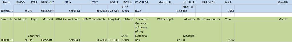

25 an example: translation of text necessary, including header info From Dutch to English
 text and of code fields")

26 an example: mapping of translated (English) text and of code fields to GeoSciML- and ODV-compliant text and code from pluriform to standardised


27 an example: using the mapping to fill the fields in the standardised ODV-format from standardised terms to a standardised database


28 North Sea wind farm summing up: - Geo-Seas helps define standards for geoscience data - Geo-Seas partners fill marine geoscience database that meets these standards - end users may query this database and - uniform database can be visualised with viewing tools BOREHOLE LOG VIEWING TOOL


29 geological boreholes, including shallow cores, provide important knowledge of the seabed subsurface viewing service that is: - quick - easy to use - reliable on everyday PCs - suitable for land and marine data - free of charge - under continuous development Vibrocorer


30 Geological Surveying and Investigation in 3D: methodology and associated software tool for 3D geologic modelling developed by Hans- Georg Sobisch: INSIGHT Geologische Softwaresysteme GSI3D Interface BGS has been acting as a test bed for the system; now lead in development

31 log viewer Porcupine developed within BGS: is able to visualise data provided in several formats through Mole, a tool that changes core data provided in these formats to code readable by log viewer Mole successfully modified to read ODV files
Dynamic preservation of the coastline
 Dynamic preservation of the coastline Content Introduction The Dutch coastal defence by dynamic processes Data collection Management of the sand resources Growing importance of marine sand and gravel resources
GLG Chapter 7 Sedimentary Environments & Rocks
 GLG 101 - Chapter 7 Sedimentary Environments & Rocks Name Note, Oct 11: I ll be writing this study sheet over the next few days. Each day I will add questions until the entire chapter is done, hopefully
Geophysical Site Surveys
 Geophysical Site Surveys Simon Oakley Geoscience Team Leader Fugro Survey Limited 16/04/2014 Contents Menu Introduction Section 1 - Geophysical Site Surveys - Seabed Bathymetry - Shallow Geology - Seabed
Sedimentary Rocks. All sedimentary rocks begin to form when existing rocks are broken down into sediments Sediments are mainly weathered debris
 Rocks! Objectives Describe the major processes involved in the formation of sedimentary rock Distinguish between clastic sedimentary rocks and chemical sedimentary rocks Identify the features that are
EMODnet data. Flanders Marine Institute. Simon Claus. A. Giorgetti, D. Schaap, A. Novellino, A. Pititto, H.Lilis, V. Henry, T.
 EMODnet data Simon Claus A. Giorgetti, D. Schaap, A. Novellino, A. Pititto, H.Lilis, V. Henry, T. Schmitt Flanders Marine Institute EMODnet data themes Types of Data Vocabularies Data Exchange Format Metadata
Tools for building and delivering 3D models Perspectives by the BGS
 Tools for building and delivering 3D models Perspectives by the BGS Holger Kessler (on behalf of the 3D community of BGS) Kingsley Dunham Centre Keyworth Nottingham NG12 5GG Tel 0115 936 3100 www.bgs.ac.uk/3dg
New EU efforts to assess the state of the marine environment: the EMODnet Chemistry pilot project
 New EU efforts to assess the state of the marine environment: the EMODnet Chemistry pilot project Matteo Vinci and Alessandra Giorgetti, OGS NODC group, OCE September 2013 - IMDIS 2013, Lucca Overview
Sedimentary Environments Chapter 8
 Sedimentary Environments Chapter 8 Does not contain complete lecture notes. To be used to help organize lecture notes and home/test studies. What is a sedimentary rock? Sedimentary rocks are products of
Igneous and Metamorphic Rock Forming Minerals. Department of Geology Mr. Victor Tibane SGM 210_2013
 Igneous and Metamorphic Rock Forming Minerals Department of Geology Mr. Victor Tibane 1 SGM 210_2013 Classification of sedimentary rocks Sedimentary rocks are products of weathered, fragmented or dissolved,
Sediment and Sedimentary rock
 Sediment and Sedimentary rock Sediment: An accumulation of loose mineral grains, such as boulders, pebbles, sand, silt or mud, which are not cemented together. Mechanical and chemical weathering produces
A Joint European GIS Under Construction: The 1:5 Million International Geological Map of Europe and Adjacent Areas (IGME 5000)
") Abstract 2001 Annual Conference of the International Association for Mathematical Geology Technical Program - Session I (Poster) Building National and Regional Geologic Map Databases A Joint European GIS
Abstract 2001 Annual Conference of the International Association for Mathematical Geology Technical Program - Session I (Poster) Building National and Regional Geologic Map Databases A Joint European GIS
Lecture Outline Wednesday - Friday February 14-16, 2018
 Lecture Outline Wednesday - Friday February 14-16, 2018 Quiz 2 scheduled for Friday Feb 23 (Interlude B, Chapters 6,7) Questions? Chapter 6 Pages of the Past: Sedimentary Rocks Key Points for today Be
Sediment and sedimentary rocks Sediment
 Sediment and sedimentary rocks Sediment From sediments to sedimentary rocks (transportation, deposition, preservation and lithification) Types of sedimentary rocks (clastic, chemical and organic) Sedimentary
EMODnet High Resolution Seabed Mapping - further developing a high resolution digital bathymetry for European seas
 EMODnet High Resolution Seabed Mapping - further developing a high resolution digital bathymetry for European seas IMDIS 2018 Conference, 7 November 2018, Barcelona - Spain Thierry Schmitt Dick M.A. Schaap
2. REGIS II: PARAMETERIZATION OF A LAYER-BASED HYDROGEOLOGICAL MODEL
 HYDRAULIC PARAMETERIZATION OF 3D SUBSURFACE MODELS: FROM MEASUREMENT-SCALE TO MODEL-SCALE Jan L. Gunnink, Jan Stafleu, Denise Maljers and Jan Hummelman TNO Geological Survey of the Netherlands, P.O. Box
Understanding Earth Fifth Edition
 Understanding Earth Fifth Edition Grotzinger Jordan Press Siever Chapter 5: SEDIMENTATION: Rocks Formed by Surface Processes Lecturer: H Mohammadzadeh Assistant professors, Department of Geology, FUM Copyright
EARTH SURFACE PROCESSES AND SEDIMENTATION!
 Sed and Strat EARTH SURFACE PROCESSES AND SEDIMENTATION! 2/27 Lecture 7- Exposure: Weathering and the Sediment Factory 3/04 Lecture 8 - Rivers and Landscapes 3/06 Lecture 9 - Waves (not Tides) 3/11 Lecture
GY 402: Sedimentary Petrology
 UNIVERSITY OF SOUTH ALABAMA GY 402: Sedimentary Petrology Lecture 12: Petrology of Immature Siliciclastic Sed. Rocks Instructor: Dr. Douglas W. Haywick Last Time 1. Factors promoting beach development
BalticBOOST Appendix 1, WP 3.3 Deliverable 1 Final report 14 February 2017
 Theme 1: Biodiversity This is a deliverable from the BalticBOOST project that was coordinated by HELCOM and co-financed by the European Union in 2015-2016 as part of the programme DG ENV/MSFD Action Plans/2016.
GY 402: Sedimentary Petrology
 UNIVERSITY OF SOUTH ALABAMA GY 402: Sedimentary Petrology Lecture 13: Immature Siliciclastic Sedimentary Environments Alluvial Fans, Braided Streams Instructor: Dr. Douglas W. Haywick Last Time Immature
Big data in the Geoscience: A portal to physical properties Andrew Kingdon, Mark Fellgett and Martin Nayembil
 Big data in the Geoscience: A portal to physical properties Andrew Kingdon, Mark Fellgett and Martin Nayembil British Geological Survey, Keyworth, Nottingham, NG12 5GG, aki@bgs.ac.uk Geosciences were early
A model of the Ipswich Urban area, geological mapping in 3D.
 A model of the Ipswich Urban area, geological mapping in 3D. Steve Mathers British Geological Survey, Keyworth, Nottingham E-mail sjma@bgs.ac.uk Background Over the last ten years the British Geological
TOWARD A GOAL OF A SUPER THREE-DIMENSIONAL GEOLOGICAL MAP
 TOWARD A GOAL OF A SUPER THREE-DIMENSIONAL GEOLOGICAL MAP Richard C. Berg 1 and David R. Soller 2 1 Illinois State Geological Survey, Champaign, IL, USA, berg@isgs.uiuc.edu 2 U.S. Geological Survey, Reston,
MESH_ElsVerfaillie_Dublin_150307_lowres.pdf English 24 (including this page)
") Title: Author(s): Document owner: Reviewed by: Workgroup: MESH action: 4 Towards high resolution habitat maps of the Southern North Sea E. Verfaillie (UGent), S. Degraer (UGent), D. Long (BGS), D. Maljers
Title: Author(s): Document owner: Reviewed by: Workgroup: MESH action: 4 Towards high resolution habitat maps of the Southern North Sea E. Verfaillie (UGent), S. Degraer (UGent), D. Long (BGS), D. Maljers
Sedimentary Rocks Chapter 6
 Sedimentary Rocks Chapter 6 I. What is a sedimentary rock? A. Sedimentary rock 1) Rock made of detrital sediments (such as sand) or inorganic/organic chemical precipitates (such as calcite) 2) Detrital
How to Identify and Properly Classify Drill Cuttings
 How to Identify and Properly Classify Drill Cuttings (Creating Useful Borehole Logs) Dave Larson Hydrogeology and Geophysics Section Accurate information about the borehole location and a careful description
Marine environment monitoring : The basic requirements to support Marine Renewable Energies
 Marine environment monitoring : The basic requirements to support Marine Renewable Energies SHOM in brief SHOM is the French Government agency in charge of Hydrography and Oceanography SHOM s vocation
UNIT 4 SEDIMENTARY ROCKS
 UNIT 4 SEDIMENTARY ROCKS WHAT ARE SEDIMENTS Sediments are loose Earth materials (unconsolidated materials) such as sand which are transported by the action of water, wind, glacial ice and gravity. These
BIM and INSPIRE, for a better integration of built infrastructures in their environment : the MINnD project
 BIM and INSPIRE, for a better integration of built infrastructures in their environment : the MINnD project François ROBIDA Christophe CASTAING Strasbourg, > 1 8 septembre 2017 ABOUT BIM Building Information
Evaluating Sustainability of the Georesources Observation System
 Evaluating Sustainability of the Georesources Observation System Michael Mente Federal Institute for Geosciences and Natural Resources Germany, Hannover GEOSS-CBC Meeting Athens April 27th 28th, 2009 GEOSS-CBC
13. Sedimentary Rocks I (p )
") 13. Sedimentary Rocks I (p. 194-208) Sediment Deposition Weathering results in rock being broken down into smaller fragments, called regolith. This regolith is then broken down to form soil. The regolith
13. Sedimentary Rocks I (p. 194-208) Sediment Deposition Weathering results in rock being broken down into smaller fragments, called regolith. This regolith is then broken down to form soil. The regolith
Geological information for Europe : Towards a pan-european Geological Data Infrastructure
 Geological information for Europe : Towards a pan-european Geological Data Infrastructure Integrating geoscientific information for EU competitiveness Co-funded by the European Union European societal
GNS Science, Lower Hutt, New Zealand NZSEE Conference
 A Ground Shaking Amplification Map for New Zealand U. Destegul, G. Dellow & D. Heron GNS Science, Lower Hutt, New Zealand. 2008 NZSEE Conference ABSTRACT: A ground shaking amplification map of New Zealand
Exercise 3 Texture of siliciclastic sediments
 Exercise 3 Texture of siliciclastic sediments Siliciclastic sediments are derived from the weathering and erosion of preexisting rocks. Once a sedimentary particle is loosened from its parent rock, it
EMODnet High Resolution Seabed Mapping - further developing and providing a high resolution digital bathymetry for European seas
 EMODnet High Resolution Seabed Mapping - further developing and providing a high resolution digital bathymetry for European seas EGU Fall 2017 meeting New Orleans USA, December 2017 Schaap Dick MARIS,
Outline Brief Overview MapPlace Website Data Delivery & Map Themes Digital Geology
 BRITISH COLUMBIA GEOLOGICAL SURVEY Kirk Hancock Pat Desjardins Nick Massey BRITISH COLUMBIA Ministry of Energy and Mines Ward Kilby acknowledged developer of MapPlace Outline Brief Overview MapPlace Website
SPINCAM Kathy Belpaeme, province West-Flanders. Ostend, 16 februari 2016
 SPINCAM Kathy Belpaeme, province West-Flanders Ostend, 16 februari 2016 The Belgian coast in a glace www.kustatlas.be The atlas in 2004 The website in 2005: The same look and feel Available in 4 languages
The Marine Environment
 The Marine Environment SECTION 16.1 Shoreline Features In your textbook, read about erosional landforms, beaches, estuaries, longshore currents, and rip currents. For each statement below, write true or
Geological 3D modelling of Quaternary sequences using GSI3D an example of the surroundings of Berne
 armasuisse Geological 3D modelling of Quaternary sequences using GSI3D an example of the surroundings of Berne 9 th Swiss Geoscience Meeting, Zurich 2011 Salomè Michael, Roland Baumberger, Nils Oesterling,
Package G2Sd. R topics documented: December 7, Type Package
 Type Package Package G2Sd December 7, 2015 Title Grain-Size Statistics and of Sediment Version 2.1.5 Date 2015-12-7 Depends R (>= 3.0.2) Imports shiny, xlsx, rjava, xlsxjars, reshape2, ggplot2, stats,
Chapter 6 Sedimentary and Metamorphic Rock
 Chapter 6 Sedimentary and Metamorphic Rock Weathering and Erosion Wherever rock is exposed at Earth s surface, it is continuously being broken down by weathering a set of physical and chemical processes
Digital Cartography in the Royal Library - the National Library of Sweden
 LIBER QUARTERLY, ISSN 1435-5205 LIBER 1999. All rights reserved K.G. Saur, Munich. Printed in Germany Digital Cartography in the Royal Library - the National Library of Sweden by GÖRAN BÄÄRNHIELM Digital
Sedimentary Rocks - are one of the three main rock types
 Today s Objective: What Makes Sedimentary Rocks Special? Sedimentary Rocks - are one of the three main rock types A sedimentary rock can form one of three ways: 1. by the deposition of the weathered remains
a national geological survey perspective François ROBIDA BRGM (French Geological Survey)
") a national geological survey perspective François ROBIDA BRGM (French Geological Survey) Pre-Conference Seminar on Socio-Economic Value of Geospatial for National and Regional Development 21 August 2017,
a national geological survey perspective François ROBIDA BRGM (French Geological Survey) Pre-Conference Seminar on Socio-Economic Value of Geospatial for National and Regional Development 21 August 2017,
Subsurface Geology of the Kennebec River
 Maine Geologic Facts and Localities July, 1998 Subsurface Geology of the Kennebec River 43 54 40.75 N, 69 48 29.01 W Text by Daniel B. Locke, Department of Agriculture, Conservation & Forestry 1 Map by
This document downloaded from vulcanhammer.net vulcanhammer.info Chet Aero Marine
 This document downloaded from vulcanhammer.net vulcanhammer.info Chet Aero Marine Don t forget to visit our companion site http://www.vulcanhammer.org Use subject to the terms and conditions of the respective
COASTAL QUATERNARY GEOLOGY MAPPING FOR NSW: EXAMPLES AND APPLICATIONS
 COASTAL QUATERNARY GEOLOGY MAPPING FOR NSW: EXAMPLES AND APPLICATIONS A Troedson Geological Survey of New South Wales Abstract Detailed geological mapping of the coastal plains of regional NSW was undertaken
The Marine Environment
 The Marine Environment SECTION 16.1 Shoreline Features In your textbook, read about erosional landforms, beaches, estuaries, longshore currents, and rip currents. For each statement below, write or. 1.
CLASSIFICATION. Classification concepts for clastic rocks have been often been. discussed by several authors. A classification is basically an attempt
 CHAPTER 11 CLASSIFICATION Classification concepts for clastic rocks have been often been discussed by several authors. A classification is basically an attempt to group the objects of concern into class
A Sedimentary Rock is..
 Sedimentary Rocks A Sedimentary Rock is.. rock formed from the lithification or crystallization of: 1. Minerals in solution 2. Organic remains 3. Materials produced by living things (biochemical) 4. Clastic
Laboratory#6 Sediment Particle Size Distribution and Turbidity Flows
 Laboratory#6 Sediment Particle Size Distribution and Turbidity Flows Although this laboratory will pertain to oceanic sediments similar processes can also be observed on land and other aquatic systems
NAME: GEL 109 Final Winter 2010
 GEL 109 Final Winter 2010 1. The following stratigraphic sections represents a single event followed by the slow accumulation of background sedimentation of shale. Describe the flows that produced the
Oil & Gas. From exploration to distribution. Week 1 V05 Origin of hydrocarbon resources part 1. Jean-Pierre Deflandre
 Oil & Gas From exploration to distribution Week 1 V05 Origin of hydrocarbon resources part 1 Jean-Pierre Deflandre W1V5 Origin of hydrocarbon resources1 p. 1 Introduction to hydrocarbon resources You will
Sedimentary Rocks. Rocks made of bits & pieces of other rocks.
 Sedimentary Rocks Rocks made of bits & pieces of other rocks. Sedimentary Rocks Igneous rocks are the most common rocks on Earth, but because most of them exist below the surface you might not have seen
NAG-City Expert Workshop Oslo 8-9. October 2012 SOSI standards and mapping for Europe (INSPIRE)
") NAG-City Expert Workshop Oslo 8-9. October 2012 SOSI standards and mapping for Europe (INSPIRE) Per Ryghaug, Geomatics The Norwegian national standard on geographic information - SOSI Started in 1984 NGU
NAG-City Expert Workshop Oslo 8-9. October 2012 SOSI standards and mapping for Europe (INSPIRE) Per Ryghaug, Geomatics The Norwegian national standard on geographic information - SOSI Started in 1984 NGU
GY 402: Sedimentary Petrology
 UNIVERSITY OF SOUTH ALABAMA GY 402: Sedimentary Petrology Lecture 2: Grain size and Descriptive Parameters Instructor: Dr. Douglas W. Haywick Lecture 2 Agenda A) Basic sediment grain size B) Ternary plots
ESC102. Sedimentary Rocks. Our keys to the past. Monday, February 11, 13
 ESC102 Sedimentary Rocks Our keys to the past Sedimentary Rocks Sedimentary rocks are rocks that form through the accumulation of sediment and the process of lithification. Lithification occurs after deposition
WEB MAP SERVICE (WMS) FOR GEOLOGICAL DATA GEORGE TUDOR
 FOR GEOLOGICAL DATA GEORGE TUDOR") WEB MAP SERVICE (WMS) FOR GEOLOGICAL DATA GEORGE TUDOR WEB MAP SERVICE (WMS) - GENERALITIES Projects with data from different sources Geological data are in different GIS software format Large amount of
WEB MAP SERVICE (WMS) FOR GEOLOGICAL DATA GEORGE TUDOR WEB MAP SERVICE (WMS) - GENERALITIES Projects with data from different sources Geological data are in different GIS software format Large amount of
A Sedimentary Rock is..
 Sedimentary Rocks A Sedimentary Rock is.. rock formed from the lithification or crystallization of: 1. Minerals in solution 2. Organic remains 3. Materials produced by living things (biochemical) 4. Clastic
DOMINANT SEDIMENTS TYPE IN ROCK Loose fragments of rocks or minerals broken off of bedrock Mineral crystals that precipitate directly out of water
 LAST NAME (ALL IN CAPS): FIRST NAME: 7. SEDIMENTARY PROCESSES, ROCKS, AND ENVIRONMENTS Instructions: Refer to Laboratory 6 in your Lab Book on pages 153-186 to answer the questions in this work sheet.
Sediment. Weathering: mechanical and chemical decomposition and disintegration of rock and minerals at the surface
 Sediment Some basic terminology Weathering: mechanical and chemical decomposition and disintegration of rock and minerals at the surface Erosion: removal of weathered rock and minerals from one place to
Sediments: a source of chemicals for the marine environment, in more than one way. Jos van Gils 1, Remi Laane 1, Kees van de Ven 2
 Sediments: a source of chemicals for the marine environment, in more than one way Jos van Gils 1, Remi Laane 1, Kees van de Ven 2 1 DELTARES, The Netherlands 2 RIJKSWATERSTAAT Water Service, The Netherlands
Sediments and Sedimentary Rocks
 Sediments and Sedimentary Rocks (Shaping Earth s Surface, Part 2) Science 330 Summer 2005 What is a sedimentary rock? Products of mechanical and chemical weathering Account for about 5 percent of Earth
Clastic Sedimentary Rocks
 Clastic Sedimentary Rocks Alessandro Grippo, Ph.D. Alternating sandstones and mudstones in Miocene turbidites Camaggiore di Firenzuola, Firenze, Italy Alessandro Grippo review Mechanical weathering creates
From the Venice Lagoon Atlas towards a collaborative federated system
 From the Venice Lagoon Atlas towards a collaborative federated system City of Venice Alessandro Mulazzani CORILA Consortium for Coordination of Research Activities Concerning the Venice Lagoon System ISMAR-CNR
General Geology Lab #4: Sedimentary Rocks and Environments
 Name General Geology Lab #4: Sedimentary Rocks and Environments Please identify the following group of sedimentary rocks. Please determine whether they clastic, biogenic or chemical. Also, answer the sample
4. The map below shows a meandering stream. Points A, B, C, and D represent locations along the stream bottom.
 1. Sediment is deposited as a river enters a lake because the A) velocity of the river decreases B) force of gravity decreases C) volume of water increases D) slope of the river increases 2. Which diagram
BUDGET. Investigation of natural sand transport on the Belgian continental shelf
 BUDGET Investigation of natural sand transport on the Belgian continental shelf Funded by Federal Office for Scientific, Technical and Cultural Affairs Program: Sustainable Management of the North Sea
GEOLOGICAL AGE OF ROCKS. Absolute geological age
 GEOLOGICAL AGE OF ROCKS Absolute geological age The pioneer of nuclear physics discovered at the turn of centuries that atoms of certain elements, the radioactive ones, spontaneously disintegrate to form
Sandstone Thin-Section Lab
 Overview In this week's lab, you will learn the basics of the description and interpretation of sandstones in thin section. For each of the ten samples listed below, you should describe the following:
EPS 50 Lab 4: Sedimentary Rocks
 Name: EPS 50 Lab 4: Sedimentary Rocks Grotzinger and Jordan, Chapter 5 Introduction In this lab we will classify sedimentary rocks and investigate the relationship between environmental conditions and
Objectives: Define Relative Age, Absolute Age
 S6E5. Students will investigate the scientific view of how the earth s surface is formed. c. Classify rocks by their process of formation. g. Describe how fossils show evidence of the changing surface
GEOL.3250 Geology for Engineers Sedimentary & Metamorphic Rocks
 GEOL.3250 Geology for Engineers Sedimentary & Metamorphic Rocks Name I. Introduction The bulk of the earth's crust is composed of relatively few minerals. These can be mixed together, however, to give
Grade 7 Science Revision Sheet for third term final exam
 Grade 7 Science Revision Sheet for third term final exam Material for the final exam : 1- Chapter 4 sections 1+2+3+4 [rock cycle + igneous rocks + sedimentary rocks + metamorphic rocks ] pages from the
Week 4/5: Limestone & Rock ages
 Week 4/5: Limestone & Rock ages Monday Warm Up: Write two things you still need to finish in order to be prepared for your presentation tomorrow. LT: I can make a presentation about my solution to a science
Geology of the Hawaiian Islands
 Geology of the Hawaiian Islands Class 12 19 February 2004 A B C D F 97 94 92 91 88 87 86 85 85 84 82 77 73 73 mean 66 64 60 69 60 57 51 29 Exam Scores Mean = 71 Median = 82/77 Any Questions? Sedimentary
Pre-Lab Reading Questions ES202
 ES202 The are designed to encourage students to read lab material prior to attending class during any given week. Reading the weekly lab prior to attending class will result in better grade performance
Correlation of gravel deposits from trenching project on Alder Creek fluvial terrace near Point Arena, California
 Correlation of gravel deposits from trenching project on Alder Creek fluvial terrace near Point Arena, California Aletha Lee Department of Geology and Geography, West Virginia University, White Hall, Morgantown,
ROCK CLASSIFICATION AND IDENTIFICATION
 Name: Miramar College Grade: GEOL 101 - Physical Geology Laboratory SEDIMENTARY ROCK CLASSIFICATION AND IDENTIFICATION PRELAB SECTION To be completed before labs starts: I. Introduction & Purpose: The
Instructor s Manual Chapter 3
 CHAPTER 3 Resource Integration Guide Chapter Outline Chapter Summary Lecture Suggestions Key Terms Web Links Virtual Field Trip Suggested Responses Chapter Outline 3.1 and the Rock Cycle 3.1a The Rock
Geotechnical Data for Transportation Infrastructure. Tim Spink, Mott MacDonald
 Geotechnical Data for Transportation Infrastructure Tim Spink, Mott MacDonald The transportation geotechnical asset Foundations Tunnels Road & track bed Earthworks Also supports: communication lines noise
European Commission STUDY ON INTERIM EVALUATION OF EUROPEAN MARINE OBSERVATION AND DATA NETWORK. Executive Summary
 European Commission STUDY ON INTERIM EVALUATION OF EUROPEAN MARINE OBSERVATION AND DATA NETWORK Executive Summary by NILOS Netherlands Institute for the Law of the Sea June 2011 Page ii Study on Interim
Mammoth Cave National Park, Kentucky
 Mammoth Cave National Park, Kentucky Objectives of Today s Lecture Refresher on Sedimentary Depositional Systems and Rock Classifications Transgressive and Regressive Marine Environments Carbonate Depositional
Assignment 2: Unit Plan 5 days
 GEOS898 UNL History on the Rocks Assignment 2: Unit Plan 5 days Mark Shearer Lincoln Southwest, Lincoln, NE 2008 1 Sedimentary Rocks Grade level: 9 th -10 th Purpose: This unit lesson will give students
PETROLEUM GEOSCIENCES GEOLOGY OR GEOPHYSICS MAJOR
 PETROLEUM GEOSCIENCES GEOLOGY OR GEOPHYSICS MAJOR APPLIED GRADUATE STUDIES Geology Geophysics GEO1 Introduction to the petroleum geosciences GEO2 Seismic methods GEO3 Multi-scale geological analysis GEO4
The Nature of Sedimentary Rocks
 The Nature of Sedimentary Rocks Sedimentary rocks are composed of: Fragments of other rocks Chemical precipitates Organic matter or biochemically produced materials The Nature of Sedimentary Rocks Sedimentary
Lecture 7: Sedimentary Rocks
 Lecture 7: Sedimentary Rocks 1. Read: Chapter 8 2. Homework #7 due Thursday 12pm 3. Midterm #1 Thursday, September 24 iclicker assignments pick yours up 001 Abreu 003 Agena 004 Albert 006 Araki 091 Atiburcio
As compaction and cementation of these sediments eventually occur, which area will become siltstone? A) A B) B C) C D) D
 A B) B C) C D) D") 1. A student obtains a cup of quartz sand from a beach. A saltwater solution is poured into the sand and allowed to evaporate. The mineral residue from the saltwater solution cements the sand grains together,
1. A student obtains a cup of quartz sand from a beach. A saltwater solution is poured into the sand and allowed to evaporate. The mineral residue from the saltwater solution cements the sand grains together,
SEDIMENT DESCRIPTION
 SEDIMENT DESCRIPTION Coring Coring at Blundell s Flat SEDIMENT DESCRIPTION Core Splitting Cores should be split into two halves using materials and procedures that will minimize disturbance and contamination,
Data and Information Management. UK All Energy 22 nd May Presented by Leo James
 Data and Information Management UK All Energy 22 nd May 2013 Presented by Leo James Strategic Development Plans Observations at the outset Data and information management and dissemination: company or
GEOLOGY MEDIA SUITE Chapter 5
 UNDERSTANDING EARTH, SIXTH EDITION GROTZINGER JORDAN GEOLOGY MEDIA SUITE Chapter 5 Sedimentation Rocks Formed by Surface Processes 2010 W.H. Freeman and Company Mineralogy of sandstones Key Figure 5.12
INSPIRE Basics. Vlado Cetl European Commission Joint Research Centre. https://ec.europa.eu/jrc/
 INSPIRE Basics Vlado Cetl European Commission Joint Research Centre https://ec.europa.eu/jrc/ Serving society Stimulating innovation Supporting legislation Outline SDI? Why European SDI? INSPIRE Policy
Collaborative Systems for the Creation of Marine Services
 Collaborative Systems for the Creation of Marine Services INSPIRE 2016 Nuno Almeida Nuno Catarino Barcelona, 28 th September 2016 Elecnor Deimos is a trademark which encompasses Elecnor Group companies
Sedimentary Rocks. Origin, Properties and Identification. Physical Geology GEOL 101 Lab Ray Rector - Instructor
 Sedimentary Rocks Origin, Properties and Identification Physical Geology GEOL 101 Lab Ray Rector - Instructor Sedimentary Rock Origin and Identification Lab Pre-Lab Internet Link Resources 1) http://www.rockhounds.com/rockshop/rockkey/index.html
What is a sedimentary rock?
 Sedimentary Rocks What is a sedimentary rock? Sedimentary rocks are products of mechanical and chemical weathering They account for only 5% of the top 10 miles of the outer crust, yet most of the earth
EMODnet-Geology. Geo-Seas International Conference Cork, Ireland 9-10 October Alan Stevenson (British Geological Survey) and the project team
 and the project team") EMODnet-Geology Geo-Seas International Conference Cork, Ireland 9-10 October 2012 Alan Stevenson (British Geological Survey) and the project team What is EMODnet? (European Marine Observation and Data
EMODnet-Geology Geo-Seas International Conference Cork, Ireland 9-10 October 2012 Alan Stevenson (British Geological Survey) and the project team What is EMODnet? (European Marine Observation and Data
FORENSIC GEOLOGY SAND SIZE-DISTRIBUTIONS AS INDICATORS OF CRIME SCENE LOCATIONS
 I. Introduction 89.215 FORENSIC GEOLOGY SAND SIZE-DISTRIBUTIONS AS INDICATORS OF CRIME SCENE LOCATIONS If you think about the world around you sand, and other sediments, occur in many environments. For
Advancing Geoscientific Capability. Geological Survey of Finland
 Advancing Geoscientific Capability Geological Survey of Finland GTK in brief The Geological Survey of Finland (GTK) is one of the largest European centres of excellence in assessment, research and the
Sediment Data for the Texas Coast
 Sediment Data for the Texas Coast Ray Newby, P.G. Coastal Geologist Coastal Resources Program Texas General Land Office George P. Bush, Land Commissioner Texas General Land Office (GLO) and the Texas Coast:
Chapter 5 Sedimentary Environments
 Chapter 3 Notes 1 Chapter 5 Sedimentary Environments A. The Tectonic Setting 1.Factors that determine the kind of sedimentary rock that will be formed in a particular area: a. the climate under which processes