Integrated Ecological Modeling and Decision Analysis within the Everglades Landscape
|
|
|
- Martina Thornton
- 5 years ago
- Views:
Transcription
1 Integrated Ecological Modeling and Decision Analysis within the Everglades Landscape GEER 2008 H. Carl Fitz Soil & Water Science Dept., Ft. Lauderdale Research & Education Center Greg Kiker Dept. of Agricultural & Biological Engineering
2 Presentation: 1. The ecological landscape models 2. Model applications 3. Decision analysis
3 Everglades Landscape Model (ELM) Goals: Develop a modeling tool for integrated ecological assessment of water management scenarios for Everglades restoration Integrate hydrology, biology, and nutrient cycling in spatially explicit, dynamic simulations Synthesize these interacting hydro-ecological processes at scales appropriate for regional assessments Understand and predict the relative responses of the landscape to different water and nutrient management scenarios Provide a conceptual and quantitative framework for collaborative field research and other modeling efforts

4 Integrated ecological landscape models at multiple scales cm NAVD83


5 Performance of ELM v2.8, 200m resolution app (being used to evaluate restoration scenarios) Median stage bias: -6 cm in marsh Median TP bias: 0 ppb TP in marsh


6 Regional ELM v2.8 application at 500 m grid resolution Stage: Median bias = 2 cm Median NS Efficiency = 0.60 Performance of the v m regional application exceeds that of ELM v2.5, for stage and water quality ELMreg500m v2.8.0

7 ELM v2.8, 500m app 1. Comparing/integrating w/ Everglades Depth Estimation Network (EDEN) 2. Available for supporting other ecological models (e.g., ATLSS) 3. Can use more accurate NAVD 1988 vertical datum: little effect on stages, but flows were different from equivalent sim using older datum Flow differences across marsh transect in central WCA-3A comparing simulations with land elevations in NGVD '29 vs NAVD '88 Flow (NGVD, 1000s acre-ft / month) 35 Higher NAVD flows Higher NGVD flows % -10% 0% 10% 20% Percent difference in flow (NGVD - NAVD) / NGVD
8 Peer Reviewed Six-month review of ELM v2.5 (1 km) application Expert Panel W. Mitsch (chair): wetland hydro-ecology, ecological modeling L. Band: hydrologic and ecological modeling C. Cerco: hydrologic and water quality modeling Panel s Report posted Jan 2007 Model is ready for application Model is...robust and will produce a unique contribution, with an integrated ecosystem paradigm, to understand and predict potential outcomes of Everglades restoration projects... Open Source code and data Extensive documentation - see web site (below)

9 ELM Design: Integrating ecological interactions 1. Boxes change in response to each other 2. Arrows denote simple model mechanisms of WHY things change 3. Using simple WHYs, model is not restricted to statistical fits of past behavior 4. Thus, apply understanding to predict relative performance of future restoration scenarios General Ecosystem Model

10 Currently not considering horizontal carbon transport & sedimentation/ resuspension
11 Presentation: 1. The ecological landscape models 2. Model applications 3. Decision analysis
12 Application: Process-Pattern interactions at century time scales 1. Apply current algorithms & parameters 2. Utilize available data on habitats, topography a) Central WCA-3A Ridge & Slough classified habitats (Rutchey et al.) b) Generate synthetic topography from USGS HAED survey points 3. Nominal conditions over 108 year simulation 4. Evaluate process - pattern interaction at century-scales a) An exploratory research application b) to stimulate discussions and collaborations


13 Generating the subregional landscape 8 Question: Can we simulate how the landscape pattern is maintained?
 accretion rates evolved over long time scales, tending towards equilibrium under these synthetic conditions 0.60 0.50 0.40 0.30 0.20 0.10 0.00-0.5 0 0.5 1 1.5 2 2.")
14 Model Experiment Results Elevation change: Strong differential peat accretion between sloughs and ridges/tree islands Frequency Distributions of Accretion Rates 107 yr simulation of Ridge & Slough mosaic Bimodal (ridge vs. slough) accretion rates evolved over long time scales, tending towards equilibrium under these synthetic conditions Accretion rate (mm/yr) 1st_10yr 1st_50yr 2nd_50yr last_10yr 100yr
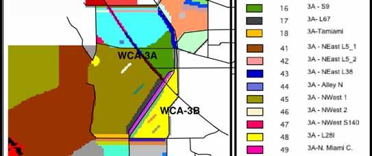
15 Application: Decompartmentalization 1. CERP Project to restore sheet flow, ecology a) Phase I focused on Miami Canal within Water Conservation Area 3-A b) Backfill entire canal, plugs along canal, or some intermediate method 2. Apply ELM v2.8 at 500 m resolution (> 40x finer than SFWMM) a) Sensitivity of hydro-ecological patterns to different canal configs b) Investigate novel Performance Measure variables 3. Use Multi-Criteria Decision Analysis tools for relative comparisons a) 3 scenarios, multiple spatial gradients, 5 Performance Measures b) Organize a complex decision c) Stimulate stakeholder discussion
 Operationally remove Miami Canal, and put 3 plugs at existing structure locations Miami Canal reaches Plug Plug Plug 3) Backfill entire Miami Canal within WCA-3A (reaches 41, 42, 43) For")
16 Scenarios (36 yr) 1) Base run = LORS07, w/ all structure flows from SFWMM v5.5 output 2) Operationally remove Miami Canal, and put 3 plugs at existing structure locations Miami Canal reaches Plug Plug Plug 3) Backfill entire Miami Canal within WCA-3A (reaches 41, 42, 43) For Scenarios 2) and 3): Divert Miami Canal inflows to new distribution canal (# 117) along northern edge No other operational changes from Base run (i.e., not restoration analysis)
17 Scenario Comparisons: 36-yr Mean Ponded Surface Water Depths some redistribution within WCA-3A (< ~6 ) Yellow/Red = Backfill is greater Plug Miami Canal Backfill minus Plug Backfill Miami Canal
18 Scenario Comparisons: 36-yr Mean TP Concentrations in Surface Water almost no difference Yellow/Red = Backfill is greater Plug Miami Canal Backfill minus Plug Backfill Miami Canal
19 Scenario Comparisons: 36-yr Mean Chloride Concentration in Surface Water redistributions within WCA-3A, some within 3B Yellow/Red = Backfill is greater Plug Miami Canal Backfill minus Plug Backfill Miami Canal
20 Scenario Comparisons: 36-yr Mean Surface Water Flow Velocities substantial redistribution within WCA-3A Yellow/Red = Backfill is greater Plug Miami Canal Backfill minus Plug Backfill Miami Canal
21 Surface water velocity - LORS07 Base Run QuickTime and a YUV420 codec decompressor are needed to see this picture.


22
23 Presentation: 1. The ecological landscape models 2. Model applications 3. Decision analysis
24 Challenges in Current Decision-Making Processes Decision-Maker(s) AD HOC Process Include/Exclude? Detailed/Vague? Certain/Uncertain? Consensus/Fragmented? Iterative? Rigid/unstructured? Quantitative? Qualitative? Tools Risk Analysis Modeling / Monitoring Cost or Benefits Stakeholders Opinion
25 Evolving Decision-Making Processes Decision-Maker(s) Decision Analytical Frameworks Agency-relevant/Stakeholder-selected Currently available software Variety of structuring techniques Iteration/reflection encouraged Identify areas for discussion/compromise Decision Integration Tool Integration Risk Analysis Modeling / Monitoring Cost Stakeholders Opinion Sharing Data,Concepts and Opinions
26 ELM-Decision Analysis Example Alternatives - Lake Okeechobee Regulation Schedule 2007 (Baseline) - Operationally remove the Miami Canal - Delete the Miami Canal from WCA-3A (Backfill) ELM-Simulated Decision Criteria - Surface Water Velocity - water flow velocity index (Velocity) - Dry Index - Mean daily duration of dry soil in upper horizon (days) - Mean daily surface water chloride concentration (CL, g/l) - Phosphorus accumulation (mg/m 2 /yr) - Extreme Dry Downs Maximum unsaturated zone depth (m) Mean unsaturated zone depths that exceeded a threshold (m) Four Spatial Zones: WC3A-Flow Transects 53 and 52, Miami Canal (Middle), Miami Canal (South)
27 Decomp DAMP Mgmt Choice Surface Water Velocity Fire Frequency Phosphorus accumulation Surface water chloride conc Extreme dry-downs Vel Zone 53 Vel Zone 52 Vel Miami Canal Middle Vel Miami Canal South Fire Miami Canal South Fire Miami Canal Middle Fire Zone 52 Fire Zone 53 P Miami Canal South P Miami Canal Middle P Zone 53 P Zone 52 CL Miami Canal Middle CL Miami Canal South CL Zone 53 CL Zone 52 XDry Zone 52 XDry Zone 53 XDry Miami Canal Middle XDry Miami Canal South MnDry Zone 52 MnDry Zone 53 MnDry Miami Canal Middle MnDry Miami Canal South LORS2007 (Baseline) Operational Removal Miami Canal Remove and Fill Miami Canal Hierarchy Rating Technique: Weights Alternatives Rating Technique: SMART with linear value functions

28 Example Decision Analysis Results Equal weights for objectives, equal weights for zones, linear value functions Contributions to Decomp Mgmt Choice from Level:Level Phosphorus accumulation Surface Water Velocity Extreme dry-downs Fire Frequency Surface water chloride conc
29 Example Decision Analysis Results Surface Water and Marsh Area emphasis on weights, linear value functions Contributions to Decomp Mgmt Choice from Level:Level Surface Water Velocity Phosphorus accumulation Extreme dry-downs Fire Frequency Surface water chloride conc
30 Discussion Modeling experiment to integrate different sets of ecosystem data: - Our decision was quite sensitive to criteria weighting and spatial zone choice. - ELM can provide useful information into structured decision analysis. - Cost was no object! (Proof of concept) Next steps: evaluate altered managed flows under different canal configurations
Water Management and Hydrology of Northeast Shark River Slough from 1940 to 2015
 Water Management and Hydrology of Northeast Shark River Slough from 1940 to 2015 Greater Everglades Ecosystem Restoration Conference April 2015 Kevin Kotun, Hydrologist Physical Resources Branch South
Ecological Patterns and Processes in Ghost Tree Islands of the Everglades
 Ecological Patterns and Processes in Ghost Tree Islands of the Everglades Sharon M. L. Ewe 1, Binhe Gu 2, Jennifer Vega 1 and Kristin Vaughan 1 1 Ecology and Environment Inc., 12300 South Shore Blvd, Wellington,
9 th INTECOL Orlando, Florida June 7, 2012
 Restoration of the Everglades Saline Wetlands and Florida Bay: Responses Driven from Land and Sea David Rudnick 1, Colin Saunders 2, Carlos Coronado 2, Fred Sklar 2 Erik Stabenau 1, Vic Engel 1, Rene Price
Flow impacts on P and OM Cycling in the Ridge and Slough:
 Flow impacts on P and OM Cycling in the Ridge and Slough: Lessons from landscape budgets in the Decomp Physical Model and Shark Slough, ENP Colin Saunders South Florida Water Management District Greater
Mosaic: Predictions from Alternative
 Flow and Pattern in the Ridge Slough Mosaic: Predictions from Alternative Mechanisms of Landform Development Matt Cohen, Danielle Watts, Todd Osborne University of Florida Jim Heffernan Florida International
Landscape-scale trends and. Islands in the Everglades. Sharon M. L. Ewe, Binhe Gu, Jennifer Vega, Kristin Vaughan, Sumanjit Aich
 Landscape-scale trends and patterns of Ghost Tree Islands in the Everglades Sharon M. L. Ewe, Binhe Gu, Jennifer Vega, Kristin Vaughan, Sumanjit Aich What is a Ghost island? Ghost island is a tree island
Enhancing and Combining Complex Numerical Models of Coastal Southern Florida
 Enhancing and Combining Complex Numerical Models of Coastal Southern Florida Eric Swain, Melinda Lohmann, and Jeremy Decker U.S. Geological Survey Florida Bay and Adjacent Marine Systems Science Conference,
Multi-scale Modeling of Ecological Systems: Systems Biology in Application to Natural Resource Management
 Multi-scale Modeling of Ecological Systems: Systems Biology in Application to Natural Resource Management Louis J. Gross The Institute for Environmental Modeling Departments of Ecology and Evolutionary
Application of an Enhanced, Fine-Scale SWAT Model to Target Land Management Practices for Maximizing Pollutant Reduction and Conservation Benefits
 Application of an Enhanced, Fine-Scale SWAT Model to Target Land Management Practices for Maximizing Pollutant Reduction and Conservation Benefits Amanda Flynn, Todd Redder, Joe DePinto, Derek Schlea Brian
Marl Prairie vegetation response to 20th century land use and its implications for management in the Everglades
 Marl Prairie vegetation response to 20th century land use and its implications for management in the Everglades C. Bernhardt, D. Willard, B. Landacre US Geological Survey Reston, VA USA U.S. Department
AUTOMATED ONLINE ECOLOGICAL MODELING AND EVALUATION FOR EVERGLADES MANAGEMENT AND RESTORATION
 AUTOMATED ONLINE ECOLOGICAL MODELING AND EVALUATION FOR EVERGLADES MANAGEMENT AND RESTORATION Leonard Pearlstine 1 Suresh Goldconda 2 Kevin Suir 3 Alicia LoGalbo 1 Craig Conzelmann 3 Janice Parsons 1 1
PRELIMINARY DRAFT FOR DISCUSSION PURPOSES
 Memorandum To: David Thompson From: John Haapala CC: Dan McDonald Bob Montgomery Date: February 24, 2003 File #: 1003551 Re: Lake Wenatchee Historic Water Levels, Operation Model, and Flood Operation This
Opportunities to Improve Ecological Functions of Floodplains and Reduce Flood Risk along Major Rivers in the Puget Sound Basin
 Opportunities to Improve Ecological Functions of Floodplains and Reduce Flood Risk along Major Rivers in the Puget Sound Basin Christopher Konrad, US Geological Survey Tim Beechie, NOAA Fisheries Managing
Distinct landscape features with important biologic, hydrologic, geomorphic, and biogeochemical functions.
 1 Distinct landscape features with important biologic, hydrologic, geomorphic, and biogeochemical functions. Have distinguishing characteristics that include low slopes, well drained soils, intermittent
Modeling Hydrodynamic Effects and Salinity Intrusion. Presented by Dr. Eric Swain, USGS Water Science Center, Fort Lauderdale Florida
 Modeling Hydrodynamic Effects and Salinity Intrusion Presented by Dr. Eric Swain, USGS Water Science Center, Fort Lauderdale Florida Requirements Because coastal South Florida has unique features such
DPM Science Team. S. Baisden S. Wilcox N. Garratt D. Crawford T. Kinsey D. George. F. Sklar C. Saunders S. Newman C. Coronado C. Zweig S.
 DPM Science Team F. Sklar C. Saunders S. Newman C. Coronado C. Zweig S. Hagerthey L. Larsen A. Hurst J. Harvey B. Rosen M. Dickman J. Choi J. Lewis E. Tate-Boldt M. Manna E. Cline C. Hansen M. Blaha F.
The Role of Wilderness in Climate Change Adaptation
 The Role of Wilderness in Climate Change Adaptation A Case Study of the Northern Rockies Greg Aplet, Bo Wilmer Goal: Sustaining Ecosystem Services Sustaining the full suite of benefits we receive from
PONDNET.WK1 - Flow and Phosphorus Routing in Pond Networks
 PONDNET.WK1 - Flow and Phosphorus Routing in Pond Networks Version 2.1 - March 1989 William W. Walker, Jr. Ph.D., Environmental Engineer 1127 Lowell Road, Concord, Massachusetts 01742 508-369-8061 PONDNET.WK1
Overview of Methods. Terrestrial areas that are most important for conservation Conservation
 Overview of Methods The goal of the Western Lake Erie Coastal Conservation Vision project (WLECCV) is to define where we should be working locally to optimally achieve regional conservation impact. The
Carbon Sequestration Potential from Coastal Wetlands Restoration Sites
 Carbon Sequestration Potential from Coastal Wetlands Restoration Sites Insert then choose Picture select your picture. Right click your picture and Send to back. Paul Krause, Alyssa Beach Emily Cooper,
Habitat Monitoring Update Hudson River CAG November 16, 2017
 Habitat Monitoring Update Hudson River CAG November 16, 2017 Habitat Reconstruction Overview: Habitats A habitat replacement program is being implemented in an Adaptive Management context to reconstruct
InSAR-based hydrology of the Everglades, South Florida
 InSAR-based hydrology of the Everglades, South Florida Shimon Wdowinski (1), Falk Amelung (1), Fernando Miralles-Wilhelm (2), Tim Dixon (1), and Richard Carande (3) (1) Division of Marine Geology and Geophysics,
Assessment and valuation of Ecosystem Services for decision-makers
 Assessment and valuation of Ecosystem Services for decision-makers An introduction to the ARIES approach Ferdinando Villa *, Ken Bagstad Gary Johnson, Marta Ceroni *Basque Center for Climate Change, Bilbao,
Data Collection and GIS Applications
 Data Collection and GIS Applications Governor s s Conference on the Management of the Illinois River System Jeff Jack of all Trades Boeckler, IDNR Introduction Collecting available GIS data sets Creating
Hydrologic Analysis for Ecosystem Restoration
 Hydrologic Analysis for Ecosystem Restoration Davis, California Objectives: To provide participants with: 1) an understanding of the issues in restoration studies; 2) an overview of Corps policies and
Connectivity Between the Mangrove Ecotone Region and Florida Bay: Current Understanding in Carbon and Nutrient Fluxes
 Connectivity Between the Mangrove Ecotone Region and Florida Bay: Current Understanding in Carbon and Nutrient Fluxes Victor H. Rivera-Monroy, Stephen E. Davis III, Robert R. Twilley, Daniel L. Childers,
A Physical Model of Flow Reconnection to Achieve Ecological Restoration in the Everglades
 A Physical Model of Flow Reconnection to Achieve Ecological Restoration in the Everglades Colin J. Saunders 1, Katherine Skalak 2, Vic Engel 3, Jud Harvey 2, David T. Ho 4, Laurel Larsen 2, Sue Newman
Estuarine Response in Northeastern Florida Bay to Major Hurricanes in 2005
 Estuarine Response in Northeastern Florida Bay to Major s in 25 By Jeff Woods and Mark Zucker s and tropical storms are critical components of the south Florida hydrologic cycle. These storms cause dramatic
Elkhorn Slough Marsh Stratigraphy
 Elkhorn Slough Marsh Stratigraphy Prehistoric marsh extent & recent sediment accretion Elizabeth Burke Watson, Ph.D. U.S. Environmental Protection Agency Narragansett, RI Paleoecology: Reconstruction of
3.0 TECHNICAL FEASIBILITY
 3.0 TECHNICAL FEASIBILITY 3.1 INTRODUCTION To enable seasonal storage and release of water from Lake Wenatchee, an impoundment structure would need to be constructed on the lake outlet channel. The structure
Everglades National Park
 National Park Service U.S. Department of the Interior Water Budget, Climate Variability, and Predicting Salinity for Eastern Florida Bay Erik Stabenau and Kevin Kotun National Park Service Erik_Stabenau@nps.gov
Climatic and Ecological Conditions in the Klamath Basin of Southern Oregon and Northern California: Projections for the Future
 Climatic and Ecological Conditions in the Klamath Basin of Southern Oregon and Northern California: Projections for the Future A Collaborative Effort by: CLIMATE LEADERSHIP INITIATIVE INSTITUTE FOR A SUSTAINABLE
Improvement of the National Hydrography Dataset for Parts of the Lower Colorado Region and Additional Areas of Importance to the DLCC
 Improvement of the National Hydrography Dataset for Parts of the Lower Colorado Region and Additional Areas of Importance to the DLCC Carlos Reyes-Andrade California State University, Northridge September
Restoration Goals TFG Meeting. Agenda
 San Joaquin River Restoration Program Restoration Goals TFG Meeting Reach 2B Update April 28, 2010 Agenda 1. Introductions 2. Program Restoration Goal Context 3. Program Update a) Interim Flows b) EIS/EIR
Dam Removal Analysis Guidelines for Sediment
 A review of: Dam Removal Analysis Guidelines for Sediment Joe Rathbun (Retired) rathbunj@sbcglobal.net Some Potential Sediment Issues Reservoir restoration Downstream water quality Downstream deposition
Visualizing Upper Trophic and Ecosystem Modeling Outputs with EverVIEW to Inform the Decision Process in Coastal Louisiana.
 Visualizing Upper Trophic and Ecosystem Modeling Outputs with EverVIEW to Inform the Decision Process in Coastal Louisiana 2012 Master Plan Craig Conzelmann Carol Parsons Richards Kevin Suir COMPREHENSIVE
The Role of the Mangrove Ecotone Region in Regulating Nutrient Cycling and Wetland Productivity in South Florida
 The Role of the Mangrove Ecotone Region in Regulating Nutrient Cycling and Wetland Productivity in South Florida Victor H. Rivera-Monroy, Stephen E. Davis III, Robert R. Twilley, Daniel L. Childers, Marc
Fig 1. Steps in the EcoValue Project
 Assessing the Social and Economic Value of Ecosystem Services in the Northern Forest Region: A Geographic Information System (GIS) Approach to Landscape Valuation Principal Investigator(s): Dr. Matthew
A Comprehensive Inventory of the Number of Modified Stream Channels in the State of Minnesota. Data, Information and Knowledge Management.
 A Comprehensive Inventory of the Number of Modified Stream Channels in the State of Minnesota Data, Information and Knowledge Management Glenn Skuta Environmental Analysis and Outcomes Division Minnesota
Statement of Impact and Objectives. Watershed Impacts. Watershed. Floodplain. Tumblin Creek Floodplain:
 Tumblin Creek Floodplain: Impacts Assessment and Conceptual Restoration Plan Casey A. Schmidt Statement of Impact and Objectives Urbanization has increased stormflow rate and volume and increased sediment,
Planning for the Future of Humboldt Bay: Sea Level Rise, Sediment Management, Sand Spits and Salt Marshes. Joel Gerwein
 Planning for the Future of Humboldt Bay: Sea Level Rise, Sediment Management, Sand Spits and Salt Marshes Joel Gerwein Introduction to Humboldt Bay Setting Economy, community, and environment Sediment
Sediment Dynamics in Restored Tidal Wetlands of San Francisco Bay
 Sediment Dynamics in Restored Tidal Wetlands of San Francisco Bay John Callaway & Jennifer Gagnon (USF) Lisa Schile (UC Berkeley) Evyan Borgnis & Tom Parker (SFSU) Donna Ball (HT Harvey & Assoc.) Gene
Module 3. Basic Ecological Principles
 Module 3. Basic Ecological Principles Ecosystem Components Abiotic Biotic Species & Habitat The Biomes of North America Communities Energy & Matter Cycles in Ecosystems Primary Productivity Simple Ecosystem
Wetland & Floodplain Functional Assessments and Mapping To Protect and Restore Riverine Systems in Vermont. Mike Kline and Laura Lapierre Vermont DEC
 Wetland & Floodplain Functional Assessments and Mapping To Protect and Restore Riverine Systems in Vermont Mike Kline and Laura Lapierre Vermont DEC NWI+ Hydro-Geomorphic Characterization of Wetlands and
Lake Tahoe Watershed Model. Lessons Learned through the Model Development Process
 Lake Tahoe Watershed Model Lessons Learned through the Model Development Process Presentation Outline Discussion of Project Objectives Model Configuration/Special Considerations Data and Research Integration
Sea Level Rise in Miami-Dade County Florida Implications for Management of Coastal Wetlands and the Everglades
 Sea Level Rise in Miami-Dade County Florida Implications for Management of Coastal Wetlands and the Everglades Peter W. Harlem Dr. John F. Meeder Florida International University Southeast Environmental
Detroit 516 Activities
 Detroit 516 Activities Dam Capacity Study Sediment Workshop in Traverse City START 2.0 Saginaw River Study Dam Capacity Study A progress report Outline Study Objective (Why are we doing this?) Reservoir
L-31N Seepage Management Field Test
 Miami-Dade Limestone Products Association 13292 N.W. 118 th Avenue Miami, FL 33178 L-31N Seepage Management Field Test The Performance of a Partially Penetrating Seepage Barrier along the L-31N Canal July
Ecosystems Chapter 4. What is an Ecosystem? Section 4-1
 Ecosystems Chapter 4 What is an Ecosystem? Section 4-1 Ecosystems Key Idea: An ecosystem includes a community of organisms and their physical environment. A community is a group of various species that
Design of Levee Breaches in Sheltered Water for Flood Risk Reduction & Marsh Restoration ASFMP; June 5, 2014 Presented By:
 Design of Levee Breaches in Sheltered Water for Flood Risk Reduction & Marsh Restoration ASFMP; June 5, 2014 Presented By: Rohin Saleh Alameda County Flood Control District Matt Powers, P.E. GEI Consultants
An evaluation of peat loss from an Everglades tree island, Florida, USA
 An evaluation of peat loss from an Everglades tree island, Florida, USA S. Aich 1, S.M.L. Ewe 2, B. Gu 3 and T.W. Dreschel 3 1 Photo Science Geospatial Solutions, St Petersburg, Florida, USA 2 Ecology
Folsom Dam Water Control Manual Update Joint Federal Project, Folsom Dam
 Folsom Dam Water Control Manual Update Joint Federal Project, Folsom Dam Public Workshop May 25, 2016 Sacramento Library Galleria 828 I Street, Sacramento, CA US Army Corps of Engineers BUILDING STRONG
Ecological Response Units Ecosystem Mapping System for the Southwest US
 Ecological Response Units Ecosystem Mapping System for the Southwest US J. C. Moreland, W. A. Robbie, F. J. Triepke, E. H. Muldavin, and J. R. Malusa Objectives What are Ecological Response Units? What
GIS-Based Sediment Quality Database for the St. Louis River Area of Concern (AOC): Overview Presentations and Demonstration
: Overview Presentations and Demonstration") GIS-Based Sediment Quality Database for the St. Louis River Area of Concern (AOC): Overview Presentations and Demonstration Judy L. Crane 1 and Dawn E. Smorong 2 1 Minnesota Pollution Control Agency, St.
GIS-Based Sediment Quality Database for the St. Louis River Area of Concern (AOC): Overview Presentations and Demonstration Judy L. Crane 1 and Dawn E. Smorong 2 1 Minnesota Pollution Control Agency, St.
UNSD SEEA-EEA revision 2020
 UNSD SEEA-EEA revision 2020 Area 1: Spatial units; introduction Sjoerd Schenau, Patrick Bogaart, Edwin Horlings London group meeting, October 2018 Overview Spatial units in SEEA EEA Main revision issues
Landscape Planning and Habitat Metrics
 Landscape Planning and Habitat Metrics Frank W. Davis National Center for Ecological Analysis and Synthesis UC Santa Barbara (Tools for Landscape Biodiversity Planning) Jimmy Kagan Institute for Natural
Biodiversity Blueprint Overview
 Biodiversity Blueprint Overview Climate Variability Climate projections for the Glenelg Hopkins Regions suggest that the weather will be hotter and drier in the coming years which will impact on land use,
APPENDIX D: WATER CONSERVATION AREA NO. 3, EVERGLADES NATIONAL PARK AND EVERGLADES NATIONAL PARK-SOUTH DADE CONVEYANCE SYSTEM OPERATIONAL GUIDANCE
 APPENDIX D: WATER CONSERVATION AREA NO. 3, EVERGLADES NATIONAL PARK AND EVERGLADES NATIONAL PARK-SOUTH DADE CONVEYANCE SYSTEM OPERATIONAL GUIDANCE DRAFT CSSS Operational Guidance for Water Conservation
Monitoring seasonal variability of the soil profile with paired deep and shallow Surface Elevation Tables (SET) in the southwest coastal Everglades.
 in the southwest coastal Everglades.") Monitoring seasonal variability of the soil profile with paired deep and shallow Surface Elevation Tables (SET) in the southwest coastal Everglades. Karen M. Balentine Advisor: Dr. Larry Rex Ellis University
Monitoring seasonal variability of the soil profile with paired deep and shallow Surface Elevation Tables (SET) in the southwest coastal Everglades. Karen M. Balentine Advisor: Dr. Larry Rex Ellis University
A Help Guide for Using gssurgo to Find Potential Wetland Soil Landscapes
 A Help Guide for Using gssurgo to Find Potential Wetland Soil Landscapes Wetland Mapping Consortium Webinar September 17, 2014 Dr. John M. Galbraith Crop & Soil Environmental Sciences Virginia Tech Wetland
Natural Resource Management. Northern Tasmania. Strategy. Appendix 2
 Natural Resource Management Strategy Northern Tasmania 2015 2020 Appendix 2 Appendix 2 Appendix 2. Carbon Planting Spatial Prioritisation In support of this Strategy s development and implementation, work
How to integrate wetland processes in river basin modeling? A West African case study
 How to integrate wetland processes in river basin modeling? A West African case study stefan.liersch@pik-potsdam.de fred.hattermann@pik-potsdam.de June 2011 Outline Why is an inundation module required?
ATLSS SESI MODEL: Long-Legged and Short-Legged Wading Birds: Foraging Indices
 ATLSS SESI MODEL: Long-Legged and Short-Legged Wading Birds: Foraging Indices Louis J. Gross, University of Tennessee ATLSS.org Provides a relative estimate of quality of pixels as sites for nesting colonies
Modeling Sea-Level Rise in Coastal Wetlands: Understanding Potential Impacts and Their Implications for Management on Cape Cod
 Modeling Sea-Level Rise in Coastal Wetlands: Understanding Potential Impacts and Their Implications for Management on Cape Cod C a p e C o a s t a l C o n f e r e n c e H y a n n i s R e s o r t a n d
Remote Sensing and Geospatial Application for Wetlands Mapping, Assessment, and Mitigation
 Remote Sensing and Geospatial Application for Wetlands Mapping, Assessment, and Mitigation Hydrology Soils MSU Seminar Series Remote Sensing and Geospatial Applications September 4, 2002 Vegetation NEPA
Upper Truckee River Restoration Lake Tahoe, California Presented by Brendan Belby Sacramento, California
 Upper Truckee River Restoration Lake Tahoe, California Presented by Brendan Belby Sacramento, California Mike Rudd (Project Manager), Charley Miller & Chad Krofta Declines in Tahoe s Water Clarity The
USGS efforts to model sea-level rise impact to tidal marshes along the California coast.
 USGS efforts to model sea-level rise impact to tidal marshes along the California coast. Karen Thorne 1 J.Y Takekawa 1, K. Buffington 1, K. Swanson 2, J. Drexler 2, D.Schoellhamer 2, M. Casazza 3, and
Mapping Predicted Tidal Exposure Durations Using a MLLW-Referenced LiDAR Terrain Model
 Mapping Predicted Tidal Exposure Durations Using a MLLW-Referenced LiDAR Terrain Model for Management of Spartina alterniflora in Willapa Bay, Washington Meeting the Challenge: Invasive Plants in PNW Ecosystems
Napa Valley Groundwater Sustainability: A Basin Analysis Report for the Napa Valley Subbasin
 Napa Valley Groundwater Sustainability: A Basin Analysis Report for the Napa Valley Subbasin A report prepared pursuant to California Water Code Section 10733.6(b)(3) EXECUTIVE SUMMARY (354.4(A)) 1 1.0
Directorate E: Sectoral and regional statistics Unit E-4: Regional statistics and geographical information LUCAS 2018.
 EUROPEAN COMMISSION EUROSTAT Directorate E: Sectoral and regional statistics Unit E-4: Regional statistics and geographical information Doc. WG/LCU 52 LUCAS 2018 Eurostat Unit E4 Working Group for Land
What is a watershed or landscape perspective?
 What is a watershed or landscape perspective? -remove sediment -add sediment -add wood, riparian manipulation -alter (engineer) channel/floodplain morphology -restore/abandon roads You are here What is
Climate also has a large influence on how local ecosystems have evolved and how we interact with them.
 The Mississippi River in a Changing Climate By Paul Lehman, P.Eng., General Manager Mississippi Valley Conservation (This article originally appeared in the Mississippi Lakes Association s 212 Mississippi
Restoring Sheetflow in a Ridge Slough Canal and Levee landscape A Synthesis of Tracers, Traps and Transport
 S O U T H F L O R I D A W A T E R M A N A G E M E N T D I S T R I C T Restoring Sheetflow in a Ridge Slough Canal and Levee landscape A Synthesis of Tracers, Traps and Transport Colin J. Saunders* Senior
Bathymetric and Sediment Survey of Atchison County Lake, Atchison County, Kansas
 Bathymetric and Sediment Survey of Atchison County Lake, Atchison County, Kansas Kansas Biological Survey Applied Science and Technology for Reservoir Assessment (ASTRA) Program Report 2010-04 (November
Bathymetric and Sediment Survey of Centralia City Lake, Nemaha County, Kansas
 Bathymetric and Sediment Survey of Centralia City Lake, Nemaha County, Kansas Kansas Biological Survey Applied Science and Technology for Reservoir Assessment (ASTRA) Program Report 2010-06 (December 2010)
Reducing Vulnerability to Extreme Heat: Science-Policy Interface
 Reducing Vulnerability to Extreme Heat: Science-Policy Interface Olga Wilhelmi, Mary Hayden, Jennifer Boehnert, Ursula Lauper and SIMMER research team October 23, 2013 Toronto SIMMER workshop Science-Policy
LOCATED IN INDIAN RIVER COUNTY PREPARED FOR S.J.R.W.M.D. AND F.W.C.D. DECEMBER, 2003 Updated 2007 Updated May 2014 PREPARED BY
 FELLSMERE WATER CONTROL DISTRICT EAST MASTER DRAINAGE PLAN AND STORMWATER HYDROLOGIC ANALYSIS OF THE GRAVITY DRAINAGE SYSTEM LOCATED BETWEEN THE EAST BOUNDARY, LATERAL U, THE MAIN CANAL, AND DITCH 24 LOCATED
Section 145 Climate Change and Sea Level Rise
 Section 145 Climate Change and Sea Level Rise A. Definitions Rhode Island Coastal Resources Management Program 1. Climate is the long-term weather average observed within a geographic region, and climate
Lower Tuolumne River Accretion (La Grange to Modesto) Estimated daily flows ( ) for the Operations Model Don Pedro Project Relicensing
 Estimated daily flows ( ) for the Operations Model Don Pedro Project Relicensing") Lower Tuolumne River Accretion (La Grange to Modesto) Estimated daily flows (1970-2010) for the Operations Model Don Pedro Project Relicensing 1.0 Objective Using available data, develop a daily time series
Lower Tuolumne River Accretion (La Grange to Modesto) Estimated daily flows (1970-2010) for the Operations Model Don Pedro Project Relicensing 1.0 Objective Using available data, develop a daily time series
COMMON CONCEPTUAL AND OPERATIONAL FRAMEWORKS FOR RESEARCH AND SUSTAINABLE MANAGEMENT OF NESTED SOCIO-ECOLOGICAL SYSTEMS ACROSS LARGE WATERSHEDS
 COMMON CONCEPTUAL AND OPERATIONAL FRAMEWORKS FOR RESEARCH AND SUSTAINABLE MANAGEMENT OF NESTED SOCIO-ECOLOGICAL SYSTEMS ACROSS LARGE WATERSHEDS Angheluta VADINEANU 1 & Nusret KARAKAYA 2 1 Department of
Multifunctional theory in agricultural land use planning case study
 Multifunctional theory in agricultural land use planning case study Introduction István Ferencsik (PhD) VÁTI Research Department, iferencsik@vati.hu By the end of 20 th century demands and expectations
Birch Creek Geomorphic Assessment and Action Plan
 Birch Creek Geomorphic Assessment and Action Plan Jim Webster Tim Hanrahan, PhD, CFM Jesse Schwartz, PhD Zach Hill January 22, 2015 White Eagle Grange This Project is a First Step in Strategy Planning
Landscape approaches for understanding and managing lakes. Dr. Kendra Spence Cheruvelil Scottish Freshwater Group 24 October 2013
 Landscape approaches for understanding and managing lakes Dr. Kendra Spence Cheruvelil Scottish Freshwater Group 24 October 2013 Making inferences from well studied ecosystems Variable Time Lake (data)
Application of GIS Technology in Watershed-based Management and Decision Making
 Application of GIS Technology in Watershed-based Management and Decision Making U. Sunday Tim Iowa State University Department of Agricultural and Biosystems Engineering 100 Davidson Hall Email:
Reading the landscape: temporal and spatial changes in a patterned peatland
 Wetlands Ecol Manage (211) 19:475 493 DOI 1.17/s11273-11-9229-z ORIGINAL PAPER Reading the landscape: temporal and spatial changes in a patterned peatland M. K. Nungesser Received: 29 June 29 / Accepted:
Coarse Sediment Augmentation on Regulated Rivers. Scott McBain McBain & Trush, Inc.
 Coarse Sediment Augmentation on Regulated Rivers Scott McBain McBain & Trush, Inc. scott@mcbaintrush.com Components Some geomorphic and ecological considerations Conceptual approach at understanding augmentation
Everglades National Park
 National Park Service U.S. Department of the Interior Climate Variability and the Coastal Physical Environment (Florida Bay) Presented by: Erik Stabenau - National Park Service Contributions from: Christina
Christopher L. Shope, Svenja Bartsch, Marianne Ruidisch, Sebastian Arnhold 6 August International SWAT Conference Ilsan, South Korea
 Tractors, Rice, and Mountains: Hydrogeochemistry in Monsoonal South Korea Christopher L. Shope, Svenja Bartsch, Marianne Ruidisch, Sebastian Arnhold 6 August 2010 2010 International SWAT Conference Ilsan,
The Refugia Concept: Using Watershed Analysis to Prioritize Salmonid Habitat for Conservation and Restoration
 The Refugia Concept: Using Watershed Analysis to Prioritize Salmonid Habitat for Conservation and Restoration Christopher May Battelle & UW Cumulative Impacts of Urbanization Landscape Alterations Loss
Ecological Valuation for Land Use Planning Decision Support in South Florida: The Ecosystem Portfolio Model
 Ecological Valuation for Land Use Planning Decision Support in South Florida: The Ecosystem Portfolio Model Bill Labiosa, Rich Bernknopf, Paul Hearn, Dianna Hogan, Dave Strong, Leonard Pearlstine, Amy
Application of SADA for 3D Subsurface Characterization and Suggested Approach for Volumetric Compliance with Decommissioning Dose Criteria
 Application of SADA for 3D Subsurface Characterization and Suggested Approach for Volumetric Compliance with Decommissioning Dose Criteria Robert Stewart, Ph.D. Oak Ridge National Laboratory University
Eco-hydromorphic Characterization of the Louisiana Coastal Region Using Multiple Remotely Sensed Data Sources and Analyses
 National Wetlands Research Center Eco-hydromorphic Characterization of the Louisiana Coastal Region Using Multiple Remotely Sensed Data Sources and Analyses 1Holly Beck, 2 Brady Couvillion, 1 Nadine Trahan
Nutrient and Sediment Cycling and Retention in Urban Floodplain Wetlands
 Nutrient and Sediment Cycling and Retention in Urban Floodplain Wetlands Greg Noe, Cliff Hupp, Nancy Rybicki, Ed Schenk, and Jackie Batson National Research Program, Reston VA U.S. Department of the Interior
Saganashkee Slough - McMahon Woods Section 506 Great Lakes Fishery & Ecosystem Restoration Study
 2015 Saganashkee Slough - McMahon Woods Section 506 Great Lakes Fishery & Ecosystem Restoration Study Appendix B Civil Design USACE Chicago District August 2015 TABLE OF CONTENTS INTRODUCTION... 3 General...
Ecological Site Descriptions ESDs : NRCS Site-based Approach to Land Classification and Evaluation. Nels Barrett, NRCS Ecologist SSSSNE 20
 Ecological Site Descriptions ESDs : NRCS Site-based Approach to Land Classification and Evaluation Nels Barrett, NRCS Ecologist SSSSNE 20 Overview Definition of Ecological Sites, ES Content of Ecological
NODE. Reconnaissance Inventory of Wetland and Sedimentation Basin Sites New and Alamo Rivers Volume lof2
 Reconnaissance Inventory of Wetland and Sedimentation Basin Sites New and Alamo Rivers Volume lof2 Prepared for The Citizen's Congressional Task Force on the New River May 2002 NODE '(YO N D ( N CI N (
Sea-level Rise on Cape Cod: How Vulnerable Are We? Rob Thieler U.S. Geological Survey Woods Hole, MA
 Sea-level Rise on Cape Cod: How Vulnerable Are We? Rob Thieler U.S. Geological Survey Woods Hole, MA Outline Sea-level and coastal processes Past sea-level change Predictions for the future Coastal responses
Mobrand to Jones and Stokes. Sustainable Fisheries Management Use of EDT
 Sustainable Fisheries Management Use of EDT Ecosystem Diagnosis and Treatment EDT EDT designed to provide a practical, science-based approach for developing and implementing watershed plans. Provides decision
The Arctic Landscape Conservation Cooperative Conservation Goals
 The Arctic Landscape Conservation Cooperative Conservation Goals Adopted by the Arctic LCC Steering Committee, 24 August 2010 Background : Landscape Conservation Cooperatives and Climate Science Centers
INTERNATIONAL RAINY LAKE BOARD OF CONTROL (IRLBC) INTERNATIONAL RAINY RIVER WATER POLLUTION BOARD (IRRWPB) NEWSLETTER.
 INTERNATIONAL RAINY RIVER WATER POLLUTION BOARD (IRRWPB) NEWSLETTER.") INTERNATIONAL RAINY LAKE BOARD OF CONTROL (IRLBC) INTERNATIONAL RAINY RIVER WATER POLLUTION BOARD (IRRWPB) NEWSLETTER 2nd Quarter 212 This newsletter provides a summary of the activities of the International
INTERNATIONAL RAINY LAKE BOARD OF CONTROL (IRLBC) INTERNATIONAL RAINY RIVER WATER POLLUTION BOARD (IRRWPB) NEWSLETTER 2nd Quarter 212 This newsletter provides a summary of the activities of the International