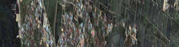
RING 2 RING 2. Banda Aceh. Quick Bird Natural Color Image 28 December Grand Mosque. 3.3km. Destroyed Shoreline/Town. Flooded. Areas.
|
|
|
- Reginald Bryan
- 6 years ago
- Views:
Transcription


1 Learning from Nanggroe Aceh Darussalam Some Notes on Post-Tsunami Rehabilitation in Calang, Aceh Jaya Dr. Widjaja Martokusumo School of Architecture, Planning and Policy Development Institut Teknologi Bandung (ITB) International Symposium on Restoration and Development of Tsunami Affected Areas in Indonesia at the University of Applied Sciences Erfurt, Germany, January 30-31, 31, 2007.
2


3
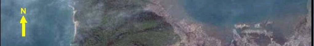
4 N Damage Assessment Approach (After pre-survey) Destroyed Shoreline/Town Banda Aceh RING 1 Flooded Areas RING 1 Flooded Areas Flooded Areas 3.3km Grand Mosque Flooded Extensive RING 2 RING 2 Areas Amounts Of Debris/Damage RING 3 Quick Bird Natural Color Image 28 December 2004 RING 3


5 Ulee Lhee Before After
6 Meulaboh
7 Earthquake-generated tsunami Nanggroe Aceh Darussalam (Aceh) was hit by earthquake generated tsunami in December 26, 2004 (2 years later the last earthquake e in Taiwan, a December 26, 2006 with 7,1 Ms at local time) Casualties more than people Physical damages and psychological l shock The long-drawn-out post-tsunami tsunami handling, ranging g from cleaning up the ruins, debris and corpses, providing water and food supply until temporary shelter, triggers increasing of diseases
 known for its fishery and marine tourism The total")

 Centre of economic activities of the")
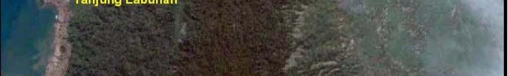
8 The Coastal Town Calang Calang, a coastal town at West Aceh, mostly a flat area (slope less than 15%) known for its fishery and marine tourism The total length of road area was 139 km Surrounded with m hills, but daily activities and routines take place along the coastal area close to the sea ( m), Figure 1: The coastal town Calang, Nanggroe Aceh Darussalam Source: (Darmoyono/Har/Octaviana, 2005) Centre of economic activities of the region Aceh Jaya


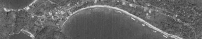

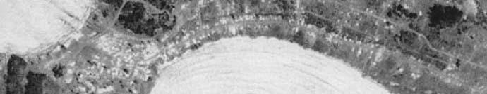
9 Calang, Aceh Jaya Before After
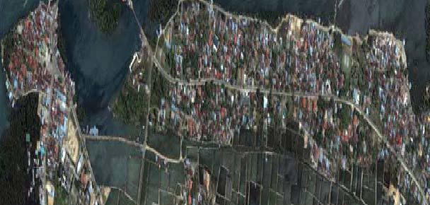
10 Calang, Aceh Jaya About 70-80% Aceh Jaya s coastal area with the height below 25 m suffers a total destruction. The horizontal inundation distance is measured up to 2-4 km from shore line. Five villages with their 3205 inhabitants were destroyed. d According to collected data (2004), the town of Calang a have 11,000-14,000 14,000 citizens, and 70% of them due to tsunami disaster have been reported died
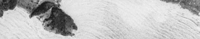
11 Calang, Aceh Jaya A small island near Calang, Aceh Jaya, which was used to be part of the main land, this picture was taken after the tsunami disaster
 Zones 2: (7-12 m altitude and 0-8% slope) Zones 3 (above 12")


12 Destruction zones Zones 1 (Shore area, 7 m altitude and 0-2% slope) Zones 2: (7-12 m altitude and 0-8% slope) Zones 3 (above 12 m altitude and 0-8% slope) All fishermen houses are completely dissapeared Flooded area Salty under-ground water Watery ground Unstable ground Structural damage Infrastructures & Public Buildings, not only destroyed, but also swept away by Tsunami Minor destruction area
 City Relocation Moderate proposing condition, with anticipative used-order area for Alt 2 disaster. Living zones are placed away from coastal-line.")
13 Settlement Relocation Alt 1 Existing condition (Easy washed-up by Tsunami because too close to coast) Extremed proposing condition by transfering city to deep village (note that the citizen must be voluntary relocate) City Relocation Moderate proposing condition, with anticipative used-order area for Alt 2 disaster. Living zones are placed away from coastal-line. Shore Zone Buffer Zone Civic Zone Commercial Zone Living Zone
 and")


14 Based on Calang Spatial Planning (RUTRK) by National Development Planning (BAPPENAS) and Public Works Departments, Calang is divided into 9 different zones to keep the city most activities at remote distance from the sea. The fishermen kampong located 1 km off-shore. The area of m from coast- line is planned for mangrove forest, and the next m is dedicated as a tourism area
15 Facts Those concepts are considered ideal, and surely they do not fit to the socio-cultural cultural context. Only a week after Tsunami some local fishermen have already rebuilt their houses next to the shore line without waiting for any formal master plan. Just like the nature of fishermen s tradition, their settlement can not be separated from the shore line/sea. The question is, how far should be the distance from the shore line?
16 Seven Principles of Design for Tsunami Resistant According to National Tsunami Hazard Mitigation Program (NTHMP, 2001), there are seven principles in designing built-up up environment for tsunami resistant: Understanding the risk of tsunami Avoid new development in tsunami run-up up areas to minimize future tsunami losses Locate and configure new development that occurs in tsunami run-up up areas to minimize future tsunami losses Design and construct new buildings to minimize tsunami damage Protect existing development from tsunami losses through redevelopment, retrofit, and land reuse plans and projects Take special precautions in locating and designing infrastructure and critical facilities to minimize tsunami damage Plan for evacuation
17 Four basic site planning techniques Avoiding inundation areas, using a raised structures above tsunami inundation levels or pier or hardened podiums Slowing water current, using green belt, ditches, slopes to strain the debris from the Steer water forces, implementing paved surfaces that create a low-friction path for water to follow Block water forces, using hardened structures, terraces, berms or parking structures or rigid structures
18 General Concept on Physical Rehabilitation ti the rehabilitation concept of Calang should be based on design considerations that t avoid and minimise the destruction of tsunami (Darmoyono/Har/Octaviana, 2005): Providing a maximum distance/space between buildings (building with large lot) Locating buildings above the tsunami flood maximum height (vertical evacuation) Locating dwelling areas behind green-belt areas or big and strong buildings Placing main access/circulations outside flood area and supported/secondary access/ circulations at 90 degree angle to coast-line.
19 Rehabilitation land use planning; ; the settlement should be located in a safe place, with accessible distance to the shore line, and supported by dwelling facilities, commercial (shops, markets), social facilities (bale, meunasah), and public (schools and clinic). circulation; ; this is a very important element for town development. Town with high accessibility can be well-developed with good orientation. Circulations are also made responding to Calang topography. green-belt; ; it will reduce the tsunami effect and prevent building development on the shore line. With the width range from 100 to 200 m and planted with mangroves along the shore the green-belt area could be functioned as a recreation park. circulation green early warning system; ; this is considered as the most important warning mechanism before disaster occurs. In general, citizens must be evacuated into safer place in relatively short time. Traditionally, the information is spread by bedug or kentongan in every house-block (5-10 houses), community centre (meunasah meunasah) ) or higher h ground (escape hills, escape buildings). The traditional communication instruments are used and effectively acceptable as warning system. Certainly, they have to be adjusted with government early-warning system which can fast-detect and warn every bedug/kentongan post.


, social")
 facilities")


20 Land Use Planning Locating temporary fishermen kampongs at radius 500 m from coastline supported by dwelling, commercial (shops, markets), social (bale, meunasah) & public (clinic, school) facilities Green Belt Calang circulation must have major evacuation lines straight to the escape-hill area. A linear-curve circulation pattern is made responding to Calang specific topography
21 mass evacuation system (horizontal and vertical evacuation); horizontal evacuation is transferring the inhabitants to safer places that is more far and/or higher (escape hill), while vertical evacuation is transferring the inhabitants to high- buildings (escape-buildings) participatory; ; it is obviously clear that without community participation, the field implementation can cause chaos, and without government and social department involved, reconstruction could not be effective. Gampong (Kampong) dwelling design; ; Gampong is Aceh s smallest community structure. It consists of about 125 housing units, meunasah, lampoh jeurat (graveyard), deyan (pesantren Islamic traditional school), krong pade (rice barn) and few bales.


22 Horizontal and vertical evacuation Escape-hill Analysis, Andi Siswanto Source : Kompas, March 3rd Horizontal evacuation transferring the citizens to safer places 2. Vertical evacuation transferring the citizens to escape hills and high-buildings (escape-buildings).
23 Shore Area Planning Sea-wall as tsunami wave barrier like most of coastal cities in Japan, but expensive Green-belt zone: coconut-trees/ coast pines or mangroves, can be utilized recreational zone as well
24 Concluding Remarks Post-disaster recovery requires a holistic approach, such as involving consultation with all relevant stakeholders, taking into account local culture, and environmental aspects including land issues. Preventing the effects by understanding the nature of tsunami.. For the case of Calang the implementation of green-belt area along the shore line with minimum width of 200 m. Decreasing land-use for permanent activities on coastal area.. To some extent, fishermen s s settlement on this area must be supported by proficient Early- Warning System (EWS).
25 Concluding Remarks Building housing that responds to earthquake and/or tsunami disaster, with spatial planning and building design, careful infrastructure and material and structure. The new re-arrangement of spatial pattern should maintain existing traditional structure and socio-cultural cultural pattern Accomplishing evacuation and early- warning system by using a combination of escape-hills (horizontal evacuation) and escape buildings (vertical evacuation).
26 Activating shore area/waterfront through attractive public activities in Shanghai.
Risk-based land use and spatial planning
 Risk-based land use and spatial planning Miho OHARA International Centre for Water Hazards and Risk Management (ICHARM) Public Works Research Institute PWRI), Japan Under the auspices of UNESCO Introduction
DATA BASE DEVELOPMENT OF ETA (ESTIMATED TIME OF ARRIVAL) FOR TSUNAMI DISASTER MITIGATION AT SOUTHWESTERN CITIES OF ACEH, INDONESIA
 FOR TSUNAMI DISASTER MITIGATION AT SOUTHWESTERN CITIES OF ACEH, INDONESIA") 6 th South China Sea Tsunami Workshop Nanyang Technology University, Singapore, 6-8 November 2013 DATA BASE DEVELOPMENT OF ETA (ESTIMATED TIME OF ARRIVAL) FOR TSUNAMI DISASTER MITIGATION AT SOUTHWESTERN
6 th South China Sea Tsunami Workshop Nanyang Technology University, Singapore, 6-8 November 2013 DATA BASE DEVELOPMENT OF ETA (ESTIMATED TIME OF ARRIVAL) FOR TSUNAMI DISASTER MITIGATION AT SOUTHWESTERN
Individual Self-help Housing Reconstruction with Relocation: Transformation of Built Environment after the Great East Japan Earthquake
 Individual Self-help Housing Reconstruction with Relocation: Transformation of Built Environment after the Great East Japan Earthquake Tamiyo Kondo, Kobe University tamiyok@people.kobe-u.ac.jp Yuka Karatani,
Predicting Tsunami Inundated Area and Evacuation Road Based On Local Condition Using GIS
 IOSR Journal of Environmental Science, Toxicology and Food Technology (IOSR-JESTFT) ISSN: 2319-2402, ISBN: 2319-2399. Volume 1, Issue 4 (Sep-Oct. 2012), PP 05-11 Predicting Tsunami Inundated Area and Evacuation
New Tsunami Disaster Mitigation System considering Local Conditions of Indian Ocean Rim Regions
 New Tsunami Disaster Mitigation System considering Local Conditions of Indian Ocean Rim Regions Kimiro Meguro Professor, Institute of Industrial Science, The University of Tokyo, Japan Shunichi Koshimura
BRIDGE DAMAGE SURVEY IN BANDA ACEH AND SURROUNDING AREAS AND EARTHQUAKE AND TSUNAMI QUESTIONNAIRES
 4th International Conference on Earthquake Engineering Taipei, Taiwan October 12-13, 2006 Paper No. 276 BRIDGE DAMAGE SURVEY IN BANDA ACEH AND SURROUNDING AREAS AND EARTHQUAKE AND TSUNAMI QUESTIONNAIRES
Remote Sensing the Urban Landscape
 Remote Sensing the Urban Landscape Urban landscape are composed of a diverse assemblage of materials (concrete, asphalt, metal, plastic, shingles, glass, water, grass, shrubbery, trees, and soil) arranged
Prevention Tsunami wall 10m high (breached by the tsunami due to land level falling by 3m)
") Plate margin Plates Causes Sendai, Japan Convergent plate margin Pacific and Eurasian Plates Convergent plate margin Sima (Pacific plate) moves towards the sial (Eurasian plate) Sima (Pacific plate) is
Plate margin Plates Causes Sendai, Japan Convergent plate margin Pacific and Eurasian Plates Convergent plate margin Sima (Pacific plate) moves towards the sial (Eurasian plate) Sima (Pacific plate) is
Disaster Prevention and Management in Asia: The Context of Human Security and Its Relevance to Infrastructure Planning and Management
 Disaster Prevention and Management in Asia: The Context of Human Security and Its Relevance to Infrastructure Planning and Management Rajib Shaw http://www.iedm.ges.kyoto-u.ac.jp/ Contents Background and
"The Big One" by sea and not by land
 "The Big One" by sea and not by land By Los Angeles Times, adapted by Newsela staff on 03.24.14 Word Count 629 Surfer Lee Johnson emerges from the water at San Onofre State Beach, Calif., with the twin
Developing fragility functions for tsunami damage estimation using the numerical model and satellite imagery
 Developing fragility functions for tsunami damage estimation using the numerical model and satellite imagery Shunichi KOSHIMURA 1 and Hideaki YANAGISAWA 2 1 Associate Professor, Disaster Control Research
(energy loss is greater with longer wavelengths)
") GEOL 0820 Ramsey Natural Disasters Spring, 2018 LECTURE #9: Tsunami Monitoring & Mitigation Date: 8 February 2018 I. Characteristics (con t): shoaling: o process of wave height increase and breaking as
GEOL 0820 Ramsey Natural Disasters Spring, 2018 LECTURE #9: Tsunami Monitoring & Mitigation Date: 8 February 2018 I. Characteristics (con t): shoaling: o process of wave height increase and breaking as
New Zealand s Next Top Model: integrating tsunami modelling into land use planning
 New Zealand s Next Top Model: integrating tsunami modelling into land use planning Wendy Saunders (MZNZPI), Gegar Prasetya, Graham Leonard GNS Science, Lower Hutt, w.saunders@gns.cri.nz In April 2011 a
What Are Disasters? The Rescue Kids Trio!
 The Rescue Kids Trio! What Are Disasters? This manual was made possible through funding by the Council of Local Authorities for International Relations. Disasters and emergency preparedness Emergency preparedness
Hurricanes. Cause: a low pressure storm system over warm ocean water. Effect: potential massive widespread destruction and flooding.
 Hurricanes Hurricanes Cause: a low pressure storm system over warm ocean water. Effect: potential massive widespread destruction and flooding. Hurricanes also known as: cyclone (Indian Ocean) or typhoon
The Restoration Process from the Great East Japan Earthquake, and Perspectives for the Sustainable Society by Creating Cultural Landscapes
 Session 3 Restoration from the Huge Natural Disasters, and Creating Cultural Landscapes for the Sustainable Society The Restoration Process from the Great East Japan Earthquake, and Perspectives for the
Wainui Beach Management Strategy (WBMS) Summary of Existing Documents. GNS Tsunami Reports
 Summary of Existing Documents. GNS Tsunami Reports") Wainui Beach Management Strategy (WBMS) Summary of Existing Documents GNS Tsunami Reports a) Review of Tsunami Hazard and Risk in New Zealand ( National Risk Report ) b) Review of New Zealand s Preparedness
Wainui Beach Management Strategy (WBMS) Summary of Existing Documents GNS Tsunami Reports a) Review of Tsunami Hazard and Risk in New Zealand ( National Risk Report ) b) Review of New Zealand s Preparedness
Controlling Processes That Change Land
 1 Name Date Controlling Processes That Change Land People try to control some of the processes that change land. To do this, people apply technology- the use of science to solve problems in everyday life.
Changes in the Level of Convenience of the Iwate Prefecture Temporary Housing Complexes Constructed after the 2011 Tohoku Earthquake
 Changes in the Level of Convenience of the Iwate Prefecture Temporary Housing Complexes Constructed after the 2011 Tohoku Earthquake Shin-ichi Konno, Risa Shibutani, and Noriaki Endo Abstract We evaluated
EXECUTIVE SUMMARY. The title of this dissertation is Quantitative Study on Natural Disasters Risk
 1 EXECUTIVE SUMMARY The title of this dissertation is Quantitative Study on Natural Disasters Risk Management Policy Applying Statistical Data Analysis and Mathematical Modeling Approach. This research
Use of Geospatial data for disaster managements
 Use of Geospatial data for disaster managements Source: http://alertsystemsgroup.com Instructor : Professor Dr. Yuji Murayama Teaching Assistant : Manjula Ranagalage What is GIS? A powerful set of tools
Building Disaster Resilience Community in Asia: Indonesian perspective
 Workshop C of the 7th Science Council of Asia (SCA) Conference Construction of Secure and Safe Society against Global Changes of Natural Disasters Okinawa, June 14 th, 2007 Building Disaster Resilience
Measuring Disaster Risk for Urban areas in Asia-Pacific
 Measuring Disaster Risk for Urban areas in Asia-Pacific Acknowledgement: Trevor Clifford, Intl Consultant 1 SDG 11 Make cities and human settlements inclusive, safe, resilient and sustainable 11.1: By
GENERAL. CHAPTER 1 BACKGROUND AND PURPOSE OF THE GUIDELINES Background of the Guidelines Purpose of the Guidelines...
 GENERAL CHAPTER 1 BACKGROUND AND PURPOSE OF THE GUIDELINES... 1 1.1 Background of the Guidelines... 1 1.2 Purpose of the Guidelines... 3 CHAPTER 2 APPLICATION OF THE GUIDELINES... 3 2.1 Potential Users
GIS and Health Information Provision in Post- Tsunami Nanggroe Aceh Darussalam
 GIS and Health Information Provision in Post- Tsunami Nanggroe Aceh Darussalam Paul Harris and Dylan Shaw Paul Harris a and Dylan Shaw b a NGIS Australia & UN Information Management Service, Banda Aceh,
Application #: TEXT
 TOWN OF FORT MYERS BEACH 2008 PROPOSED COMPREHENSIVE PLAN AMENDMENTS Application #: 2008-13-TEXT Description: Modify the Coastal Management and Future Land Use Elements to reflect the state s new definition
Geospatial application in Kiribati
 Geospatial application in Kiribati ICC-21 ST RESAP (9 TH TO 13 TH OCTOBER, 2017) BANGKOK, THAILAND Outline Kiribati Profile Natural disasters in Kiribati Achievements Challenges/Issues Ways forward 1 Kiribati
Impact of Cyclone Nargis
 Lessons Learnt from Nargis Recovery for the Next Disaster International Recovery Forum (2011) 12, JAN 2011, Kobe, Japan Home for over 100 national races. Profile of Myanmar The 2 nd largest country in
Pacific Catastrophe Risk Assessment And Financing Initiative
 Pacific Catastrophe Risk Assessment And Financing Initiative PALAU September is expected to incur, on average,.7 million USD per year in losses due to earthquakes and tropical cyclones. In the next 5 years,
DEVASTATING DAMAGE DUE TO THE 2004 INDIAN OCEAN TSUNAMI AND ITS LESSONS
 DEVASTATING DAMAGE DUE TO THE 2004 INDIAN OCEAN TSUNAMI AND ITS LESSONS Fumihiko Imamura 1 1 Professor, Tsunami Engineering, Disaster Control Research Center, Tohoku University, Japan Email: imamura@tsunami2.civil.tohoku.ac.jp
Coastal Vulnerability Assessment in Semarang City, Indonesia Based on Sea Level Rise and Land Subsidence Scenarios
 Coastal Vulnerability Assessment in Semarang City, Indonesia Based on Sea Level Rise and Land Subsidence Scenarios I. M. Radjawane, D. Hartadi and W. R. Lusano Oceanography Research Division Fac. of Earth
We have previously looked at artificial seismograms such as this one here.
 We have previously looked at artificial seismograms such as this one here. S P A realistic Seismic Record Each vertical line = 1 minute Each horizontal line = 15 minutes Seismic station PMM is in Parkfield,
KNOWLEDGE NOTE 5-1. Risk Assessment and Hazard Mapping. CLUSTER 5: Hazard and Risk Information and Decision Making. Public Disclosure Authorized
 Public Disclosure Authorized Public Disclosure Authorized Public Disclosure Authorized Public Disclosure Authorized KNOWLEDGE NOTE 5-1 CLUSTER 5: Hazard and Risk Information and Decision Making Risk Assessment
Copernicus Overview. Major Emergency Management Conference Athlone 2017
 Copernicus Overview Major Emergency Management Conference Athlone 2017 Copernicus is a European programme implemented by the European Commission. The services address six thematic areas: land, marine,
Living in the shadow of Italy's volcanoes
 Living in the shadow of Italy's volcanoes Throughout Etna s history, nearby towns and cities have been threatened by ash falls, lava flows and earthquakes. Figure 1 shows a house destroyed by a recent
Mechanism of tsunami generation,propagation and runup -sharing experiences with Japanese
 Mechanism of tsunami generation,propagation and runup -sharing experiences with Japanese Mechanism of tsunami generation Predicting the propagation, runup and inundation of tsunamis Near and far-field
Not all eruptions are the same. Sometimes, there is a huge explosion. The hot magma shoots
 Natural Disasters A natural disaster is an event that happens in nature. It is an event that can cause a lot of damage. Volcanoes, earthquakes, and tsunamis are all natural disasters. Volcanoes A volcano
Overview of Consequences of the Tsunami in Thailand and Roles and Activities of the Department of Mineral Resources after the 26 December 2004 Tsunami
 Overview of Consequences of the Tsunami in Thailand and Roles and Activities of the after the 26 December 2004 Tsunami By Mr.Worawoot Tantiwanit, Thailand 1 Earthquake in NW of North Sumatra Island 580
Paper Reference. Paper Reference(s) 1312/2F Edexcel GCSE Geography A Foundation Tier. Monday 11 June 2007 Afternoon Time: 1 hour 15 minutes
 1312/2F Edexcel GCSE Geography A Foundation Tier. Monday 11 June 2007 Afternoon Time: 1 hour 15 minutes") Centre No. Paper Reference Surname Initial(s) Candidate No. 1 3 1 2 2 F Signature Paper Reference(s) 1312/2F Edexcel GCSE Geography A Foundation Tier Paper 2F Monday 11 June 2007 Afternoon Time: 1 hour
Centre No. Paper Reference Surname Initial(s) Candidate No. 1 3 1 2 2 F Signature Paper Reference(s) 1312/2F Edexcel GCSE Geography A Foundation Tier Paper 2F Monday 11 June 2007 Afternoon Time: 1 hour
Managing Floods at Boscastle. Learning Objective: Examine the benefits of managing floods
 Managing Floods at Boscastle Learning Objective: Examine the benefits of managing floods Learning Outcomes: Describe how Boscastle has been affected by flooding Explain strategies to reduce the risk Evaluate
Abdul Muhari 1, Fumihiko Imamura 2, Taro Arikawa 3, and Bagus Afriyanto 1. Date; 15 October 2018
 Finding of the unexpected tsunami due to the strike-slip fault at central Sulawesi, Indonesia on 28 September 2018, from the preliminary field survey at Palu Abdul Muhari 1, Fumihiko Imamura 2, Taro Arikawa
The Integration of Land and Marine Spatial Data Set As Part of Indonesian Spatial Data Infrastructure Development
 UNITED NATIONS E/CONF.97/6/IP. 46 ECONOMIC AND SOCIAL COUNCIL Seventeenth United Nations Regional Cartographic Conference for Asia and the Pacific Bangkok, 18-22 September 2006 Item 7 of the provisional
Sentinel Asia Tsunami Working Group
 Sentinel Asia Tsunami Working Group Co-Chairman: Prof. Shunichi Koshimura Abdul Muhari, PhD 4 th Joint Project Team Meeting (JPTM 2017): Sentinel Asia STEP 3 Abdul MUHARI, PhD Ministry of Marine Affairs
National Disaster Management Centre (NDMC) Republic of Maldives. Location
 Republic of Maldives. Location") National Disaster Management Centre (NDMC) Republic of Maldives Location Country Profile 1,190 islands. 198 Inhabited Islands. Total land area 300 sq km Islands range b/w 0.2 5 sq km Population approx.
National Disaster Management Centre (NDMC) Republic of Maldives Location Country Profile 1,190 islands. 198 Inhabited Islands. Total land area 300 sq km Islands range b/w 0.2 5 sq km Population approx.
Sri Lanka has a coastline of km excluding the shoreline of bays and inlets.
 Defining and Demarcating Coastal zones in Sri Lanka Procedure, Challenges and What needs to be done? Dr. Anil Premaratne Director General Coast Conservation Coast Conservation Department Sri Lanka 1 Sri
Natural Processes. Were you prepared for the fast approaching storm? Were you able to take shelter? What about pets, livestock or plants?
 Have you ever been caught in a storm? You are outside on a summer night and all of a sudden here come the wind, lightning and heavy rain. It starts raining so hard that you can hardly see in front of you.
Cascadia Seismic Event Planning for the Maritime Community
 Cascadia Seismic Event Planning for the Maritime Community Jonathan Allan, Oregon Dept. of Geology and Mineral Industries Presentation to Annual Pacific Northwest Waterways Association Meeting (PNWA) October
SIMPLE GUIDELINES TO MINIMISE EXPOSURE TO EARTHQUAKE-TRIGGERED LANDSLIDES
 SIMPLE GUIDELINES TO MINIMISE EXPOSURE TO EARTHQUAKE-TRIGGERED LANDSLIDES David Milledge, Nick Rosser, Katie Oven, Amod Mani Dixit, Ranjan Dhungel, Gopi Krishna Basyal, Sujan Raj Adhikari and Alexander
"The Natural Disasters, like The Sumatra Tsunami had taught us before -BUT" U Than Myint President Myanmar Engineering Society
 "The Natural Disasters, like The Sumatra Tsunami had taught us before -BUT" U Than Myint President Myanmar Engineering Society Present Day Regional Tectonic Setting of South East Asia Tsunami-generated
What causes a tsunami?
 Listen: Have this page read to you [1] Have this page read to you [2] A tsunami is a series of waves in the sea caused by a movement on the sea floor. New Zealand is at risk from tsunami because it has
Table-Top Exercise for Emergency Preparedness Evaluation: Little Anse, Isle Madame
 Table-Top Exercise for Emergency Preparedness Evaluation: Little Anse, Isle Madame Alexander Chung, M.Sc. Candidate C-Change Student Research Associate May 2013 The Community of Little Anse Coastal community
EIT-Japan Symposium 2011 on Human Security Engineering
 EIT-Japan Symposium 2011 on Human Security Engineering 2011 Disastrous Landslides at Khao Panom, Krabi, Thailand Suttisak Soralump Geotechnical Engineering Research and Development Center (GERD) Faculty
Lorna V Inniss, Ph.D SAGE Workshop, New York City
 Lorna V Inniss, Ph.D SAGE Workshop, New York City 2014-05-21 Why me? The globally recognized success of the Barbados ICZM programme has generated requests for technical assistance and CD from many Governments
Natural Disasters Spring, LECTURE #8: Earthquake Disasters: Monitoring & Mitigation. Date: 1 Feb 2018 (lecturer: Dr.
 GEOL 0820 Ramsey Natural Disasters Spring, 2018 LECTURE #8: Earthquake Disasters: Monitoring & Mitigation Date: 1 Feb 2018 (lecturer: Dr. Shawn Wright) I. Exam I - Reminder Feb 6 th next class details:
Tsunami! Beyond the Book. FOCUS Book
 FOCUS Book Use the engineering design process to design a structure that will protect a coastal town from possible tsunami damage. Brainstorm design ideas for your structure with a group of classmates.
Evacuation Alarm Using the Improved Magnitude Method to Damage Caused by Typhoon 9918
 ICHE 2014, Hamburg - Lehfeldt & Kopmann (eds) - 2014 Bundesanstalt für Wasserbau ISBN 978-3-939230-32-8 Evacuation Alarm Using the Improved Magnitude Method to Damage Caused by Typhoon 9918 R. Hashimura
Ayubowan. Management (CBDRM) Community Based Disaster Risk. Towards Disaster Resilient Community Developed by Disaster Management Centre,
 Community Based Disaster Risk. Towards Disaster Resilient Community Developed by Disaster Management Centre,") Ayubowan Community Based Disaster Risk Management (CBDRM) Towards Disaster Resilient Community 5-20 Purpose of this activity To know the risks in community to prepare for future disasters To exchange knowledge
Ayubowan Community Based Disaster Risk Management (CBDRM) Towards Disaster Resilient Community 5-20 Purpose of this activity To know the risks in community to prepare for future disasters To exchange knowledge
Strategic approach towards Post Tsunami Mitigation and Conservation of the Sri Lankan coastline
 Strategic approach towards Post Tsunami Mitigation and Conservation of the Sri Lankan coastline Dr. S.S.L.Hettiarachchi Dr. S.P.Samarawickrama University of Moratuwa Illustrated via a Case Study for the
Coastal Resiliency: Planning for Natural Variability and Recovering from Extreme Events
 Coastal Resiliency: Planning for Natural Variability and Recovering from Extreme Events Stephanie Showalter, J.D., M.S.E.L. Director, National Sea Grant Law Center University of Mississippi Coastal Hazards
Tsunami Risk Mitigation Strategy for Thailand. Kjell Karlsrud Norwegian Geotechnical Institute (NGI)
") Tsunami Risk Mitigation Strategy for Thailand Kjell Karlsrud Norwegian Geotechnical Institute (NGI) The project was undertaken by NGI in cooperation with: NORSAR, UiB, UiO, NIBR, B.Heyerdahl, NTNU, Sintef
Tsunami Risk Mitigation Strategy for Thailand Kjell Karlsrud Norwegian Geotechnical Institute (NGI) The project was undertaken by NGI in cooperation with: NORSAR, UiB, UiO, NIBR, B.Heyerdahl, NTNU, Sintef
VULNERABILITY FUNCTIONS FOR BUILDINGS BASED ON DAMAGE SURVEY DATA IN SRI LANKA AFTER THE 2004 INDIAN OCEAN TSUNAMI. Murao, O. 1, Nakazato, H.
 371 VULNERABILITY FUNCTIONS FOR BUILDINGS BASED ON DAMAGE SURVEY DATA IN SRI LANKA AFTER THE 2004 INDIAN OCEAN TSUNAMI Murao, O. 1, Nakazato, H. 2 1 Graduate School of Systems and Information Engineering,
Outline of Guideline for Development and Utilization of Tsunami Disaster Management Map
 Outline of Guideline for Development and Utilization of Tsunami Disaster Management Map Port and Airport Research Institute, Japan The Overseas Coastal Area Development Institute of Japan Ports and Harbours
Lessons Learned from Past Tsunamis Warning and Emergency Response
 UNESCO IOC CTIC US NOAA ITIC Regional Training Workshop on Strengthening Tsunami Warning and Emergency Response Standard Operating Procedures and the Development of the ICG/CARIBE-EWS PTWC New Enhanced
Disaster Risk Assessment: Opportunities for GIS and data management with Open DRI
 Disaster Risk Assessment: Opportunities for GIS and data management with Open DRI Jacob Opadeyi Department of Geomatics Engineering and Land Management, The University of the West Indies, St. Augustine,
Geography Education Challenges Regarding Disaster Mitigation in Japan
 Geography Education Challenges Regarding Disaster Mitigation in Japan Koji OHNISHI 1 University of Toyama, Toyama, JAPAN Hiroshi MITSUHASHI 2 Ministry of Education, Culture, Sports, Science & Technology,
Trends of Natural Disasters in the Asia- Pacific Region and the Direction of Disaster Management
 2016 APEC SCCC, Arequipa, Peru Session 6 - Human Security: Food, Health, Natural Disasters and Environmental Issues Trends of Natural Disasters in the Asia- Pacific Region and the Direction of Disaster
Cascadia Preparedness. Tsunami Road Show 2012
 Cascadia Preparedness Tsunami Road Show 2012 Why we re here talking about earthquakes and tsunamis. Getting from here to there What we ll be talking about Cascadia Subduction Zone March 11 Japanese earthquake
ANALYSIS OF EVACUATION BEHAVIORS IN DIFFERENT AREAS BEFORE AND AFTER THE GREAT EAST JAPAN EARTHQUAKE
 Fifth International Conference on Geotechnique, Construction Materials and Environment, Osaka, Japan, Nov. 16-18, 2015, ISBN: 978-4-9905958-4-5 C3051 ANALYSIS OF EVACUATION BEHAVIORS IN DIFFERENT AREAS
GUIDELINES FOR CONSTRUCTION TECHNOLOGY TRANSFER DEVELOPMENT OF WARNING AND EVACUATION SYSTEM AGAINST SEDIMENT DISASTERS IN DEVELOPING COUNTRIES
 GUIDELINES FOR CONSTRUCTION TECHNOLOGY TRANSFER DEVELOPMENT OF WARNING AND EVACUATION SYSTEM AGAINST SEDIMENT DISASTERS IN DEVELOPING COUNTRIES MARCH 2004 Ministry of Land, Infrastructure and Transport
Predicting of Tsunami Inundation Area based on Propagation and Runup Numerical Model in Pacitan City
 Predicting of Tsunami Inundation Area based on Propagation and Runup Numerical Model in Pacitan City 1 Agus Suharyanto, 1 Alwafi Pujiraharjo, 2 Adipandang Yudono, 3 Keisuke Murakami, and 3 Chikashi Deguchi
Pacific Catastrophe Risk Assessment And Financing Initiative
 Pacific Catastrophe Risk Assessment And Financing Initiative VANUATU September 211 Country Risk Profile: VANUATU is expected to incur, on average, 48 million USD per year in losses due to earthquakes and
Disaster Risk Management in India. Kamal Kishore New Delhi, 27 October 2016
 Disaster Risk Management in India Kamal Kishore New Delhi, 27 October 2016 Hazard, Exposure and Vulnerability Disaster Prevention Mitigation Hurricane Matthew: Cuba & Haiti Emergency Response Coordination
SPICE & Disaster Risk Managment
 SPICE & Disaster Risk Managment Linking Integrated Coastal Zone Management (ICZM) with Tsunami Disaster Risk Management: Some Experiences from Capacity Building Measures in Indonesia International Symposium
Disclaimer. This report was compiled by an ADRC visiting researcher (VR) from ADRC member countries.
 from ADRC member countries.") Disclaimer This report was compiled by an ADRC visiting researcher (VR) from ADRC member countries. The views expressed in the report do not necessarily reflect the views of the ADRC. The boundaries and
Disclaimer This report was compiled by an ADRC visiting researcher (VR) from ADRC member countries. The views expressed in the report do not necessarily reflect the views of the ADRC. The boundaries and
Surviving the Big One: Understanding and Preparing for a Major Earthquake in Western Oregon
 Surviving the Big One: Understanding and Preparing for a Major Earthquake in Western Oregon May 21, 2013 City of Salem Salem Public Library Althea Rizzo, Geological Hazards Program Coordinator Oregon Emergency
Introduction to Environmental Geology, 5e Case History: Indonesian Tsunami Indonesian Tsunami (2) Introduction Historic Tsunamis
 Introduction Historic Tsunamis") 1 2 3 4 5 6 7 8 9 Introduction to Environmental Geology, 5e Chapter 7 Tsunami Case History: Indonesian Tsunami December 26, 2004, within a few hours, close to 250,000 people were killed With no warning
1 2 3 4 5 6 7 8 9 Introduction to Environmental Geology, 5e Chapter 7 Tsunami Case History: Indonesian Tsunami December 26, 2004, within a few hours, close to 250,000 people were killed With no warning
Earthquake Hazards. Tsunami
 Earthquake Hazards Tsunami Measuring Earthquakes Two measurements that describe the power or strength of an earthquake are: Intensity a measure of the degree of earthquake shaking at a given locale based
CERTIFIED RESOLUTION. introduction: and dated May 29, 2017, as attached, as appropriate
 15322 Buena Vista Avenue, White Rock BC, Canada V4B 1Y6 www.whiterockcity.ca City of White Rock P: 604.541.22121 F: 604.541.9348 /2tC% City Clerk s Office IT E ROC K June 13,2017 Stephanie Lam, Deputy
Earthquake Hazards. Tsunami
 Earthquake Hazards Tsunami Review: What is an earthquake? Earthquake is the vibration (shaking) and/or displacement of the ground produced by the sudden release of energy. The point inside the Earth where
GEOLOGICAL HAZARD MITIGATION STRATEGY IN INDONESIA
 GEOLOGICAL HAZARD MITIGATION STRATEGY IN INDONESIA Surono Head of Geological Agency presented in: The 2nd Global Summit of Research Institutes for Disaster Risk Reduction Kihada Hall, Uji Campus, Kyoto
SOCIO-ECONOMIC IMPACTS OF FLOODING IN DIRE DAWA, ETHIOPIA
 SOCIO-ECONOMIC IMPACTS OF FLOODING IN DIRE DAWA, ETHIOPIA Alemu Yonas Tadesse * Supervisor: Prof. A.W. Jayawardena ** MEE08182 ABSTRACT Dire Dawa, the second largest city of Ethiopia, has been suffering
Numerical simulations for Investigation of the Coastline Erosion due to the 2004 Indian Ocean Tsunami
 Numerical simulations for Investigation of the Coastline Erosion due to the 2004 Indian Ocean Tsunami Syamsidik, Musa Al ala, Mirza Fahmi, and Tursina Tsunami Computation and Visualization Laboratory Tsunami
Local Area Key Issues Paper No. 13: Southern Hinterland townships growth opportunities
 Draft Sunshine Coast Planning Scheme Review of Submissions Local Area Key Issues Paper No. 13: Southern Hinterland townships growth opportunities Key Issue: Growth opportunities for Southern Hinterland
ILO Assessment Report: Community Based Emergency Employment Nabulini, Manu and Naibita Village.
 ILO Assessment Report: Community Based Emergency Employment Nabulini, Manu and Naibita Village. Back ground: The category 5 tropical cyclone Winston (TCW) which made landfall in Fiji on 20th February 2016
Paper Reference. Paper Reference(s) 1312/4H Edexcel GCSE Geography A Higher Tier. Monday 11 June 2007 Afternoon Time: 1 hour 15 minutes
 1312/4H Edexcel GCSE Geography A Higher Tier. Monday 11 June 2007 Afternoon Time: 1 hour 15 minutes") Centre No. Paper Reference Surname Initial(s) Candidate No. 1 3 1 2 4 H Signature Paper Reference(s) 1312/4H Edexcel GCSE Geography A Higher Tier Paper 4H Monday 11 June 2007 Afternoon Time: 1 hour 15
Centre No. Paper Reference Surname Initial(s) Candidate No. 1 3 1 2 4 H Signature Paper Reference(s) 1312/4H Edexcel GCSE Geography A Higher Tier Paper 4H Monday 11 June 2007 Afternoon Time: 1 hour 15
Phases of Disaster Response. John Yeaw, Gavin Vanstone, Haochen Wu, Jordan Tyler
 Phases of Disaster Response John Yeaw, Gavin Vanstone, Haochen Wu, Jordan Tyler BP Oil Spill One of the worst man made disasters in human history The BP oil spill occurred in April of 2010 when the Deepwater
Initiative. Country Risk Profile: papua new guinea. Better Risk Information for Smarter Investments PAPUA NEW GUINEA.
 Pacific Catastrophe Risk Assessment And Financing Initiative PAPUA NEW GUINEA September 211 Country Risk Profile: papua new is expected to incur, on average, 85 million USD per year in losses due to earthquakes
Risk sensitive landscape planning and design: case study of the Prince Islands, Istanbul
 Disaster Management and Human Health Risk IV 183 Risk sensitive landscape planning and design: case study of the Prince Islands, Istanbul F. A. Turer Baskaya Department of Landscape Architecture, Faculty
Lyme Regis. Environmental Improvements Phase 2. Securing the future of Lyme Regis
 Lyme Regis Environmental Improvements Phase 2 Securing the future of Lyme Regis Wave attack on Marine Parade The spectacular scenery around Lyme Regis is a result of erosion by the sea and landsliding
Proposed Scope of Work Village of Farmingdale Downtown Farmingdale BOA Step 2 BOA Nomination Study / Draft Generic Environmental Impact Statement
 Proposed Scope of Work Village of Farmingdale Downtown Farmingdale BOA Step 2 BOA Nomination Study / Draft Generic Environmental Impact Statement The scope of work that follows incorporates and covers
International Symposium on Natural Disaster Mitigation. Local vulnerability assessment of landslides and debris flows
 International Symposium on Natural Disaster Mitigation of landslides and debris flows Lessons learnt from Cam Pha town and Van Don district, Quang Ninh province, Vietnam Nguyen Quoc Phi Faculty of Environment
M14/3/GEOGR/SP2/ENG/TZ0/XX/Q GEOGRAPHY STANDARD LEVEL PAPER 2. Monday 19 May 2014 (morning) 1 hour 20 minutes INSTRUCTIONS TO CANDIDATES
 1 hour 20 minutes INSTRUCTIONS TO CANDIDATES") M14/3/GEOGR/SP2/ENG/TZ0/XX/Q 22145203 GEOGRAPHY STANDARD LEVEL PAPER 2 Monday 19 May 2014 (morning) 1 hour 20 minutes INSTRUCTIONS TO CANDIDATES Do not open this examination paper until instructed to do
M14/3/GEOGR/SP2/ENG/TZ0/XX/Q 22145203 GEOGRAPHY STANDARD LEVEL PAPER 2 Monday 19 May 2014 (morning) 1 hour 20 minutes INSTRUCTIONS TO CANDIDATES Do not open this examination paper until instructed to do
Jeopardy. Final Jeopardy $100 $100 $100 $100 $100 $200 $200 $200 $200 $200 $300 $300 $300 $300 $400 $400 $400 $500 $500 $500 $500 $500
 Jeopardy Earthquakes Volcanoes Tsunamis Wildfires Landslides/ Droughts $100 $100 $100 $100 $100 $200 $200 $200 $200 $200 $300 $300 $300 $300 $300 $400 $400 $400 $400 $400 $500 $500 $500 $500 $500 Final
Landslide Disaster Management in Sri Lanka and Nichola Oya as a Case study. Group 16 Gamini Jayathissa Udeni Nawagamuwa
 Landslide Disaster Management in Sri Lanka and Nichola Oya as a Case study Group 16 Gamini Jayathissa Udeni Nawagamuwa Taiwan Sri lanka >2582 mm, max >5000mm NE= Nov. to Feb 1750 2500 mm >2500 mm Central
Vietnam Coastal Erosion - Cause and Challenges -
 Administration of Sea and Islands Center for Oceanography University of Transport and Communications, Hanoi Vietnam Vietnam Coastal Erosion - Cause and Challenges - Presenters: Pham Hoang KIEN Le Van CONG
The Contested Cultural Landscape of a Lebanese Border Town: MARJA AYOUN
 The Contested Cultural Landscape of a Lebanese Border Town: MARJA AYOUN IBD 2013 FNAS MAY 2013 Dr. Christine Mady, City & Regional Planning NDU -FAAD In this Presentation A PLANNING PERSPECTIVE INTRODUCING
Publishable Summary. Summary Description of the project context and main objectives
 Publishable Summary Summary Description of the project context and main objectives Tsunamis are low frequency but high impact natural disasters. In 2004, the Boxing Day tsunami killed hundreds of thousands
Natural Disasters PASSAGE 5
 PASSAGE 5 Name Directions: Read Natural Disasters. Then answer questions 1 8. Natural Disasters Our planet can be a calm place, but weather conditions often change rapidly. Gentle breezes can blow into
Hurricanes 1. Thunderclouds. cool, dry air falls. warm, moist air rises
 Hurricanes 1 Hurricanes are gigantic tropical storms that can be hundreds of kilometres wide. They bring along very strong winds and a lot of rainfall. They often cause flooding near the coasts and sea
BUILDING STRUCTURES ON OR NEAR STEEP SLOPES
 BUILDING STRUCTURES ON OR NEAR STEEP SLOPES Benefits of Building Structures on or Near Steep Slopes Why would you ever do this? In some instances, it is the steep slope that people want to be near. Like